A Digital Twin of the terrestrial water cycle: a glimpse into the future through high-resolution Earth observations
Explainer
Front Sci, 05 March 2024
This explainer is part of an article hub, related to lead article https://doi.org/10.3389/fsci.2023.1190191
A virtual copy of the Earth’s water cycle
Google Earth allows anyone with access to a computer and the internet to explore our planet’s surface in incredible detail. What if we could also see temperature, rainfall, and other phenomena at the same level of detail? And watch how these change with time—or even "experiment" with their values to see what may happen in the future?
Digital twin Earths promise exactly this. These virtual models aim to accurately simulate natural processes and human impacts on the environment, so that we can monitor our planet’s health, explore possible future scenarios, and assess the risk of natural disasters like floods and droughts. Such information is vital for sustainable development and protecting vulnerable populations—especially as climate change and human activities are increasingly affecting ecosystems, biodiversity, and the frequency and intensity of extreme weather events.
Brocca et al. describe a tremendous step forward in delivering this promise: virtual replicas of the terrestrial water cycle at unprecedented resolution and accuracy. Their Frontiers in Science lead article—and this explainer—describes how the "Digital Twin Earth Hydrology Platform" was created as well as its practical applications. The authors also present a roadmap for expanding their demonstration models from four case studies in the Mediterranean Basin to a continental and global scale.
What is a digital twin Earth?
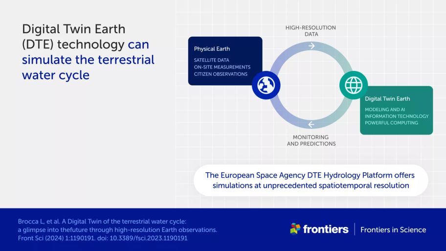
A digital twin Earth is a virtual replica of our physical planet that can accurately visualize and mimic natural processes and the impact of human activities. Its purpose is twofold: to improve our understanding of planetary processes, and to inform decision-making on a wide range of issues—from resource management and urban planning to disaster preparedness and climate change mitigation.
Digital twin Earths—also called Earth system digital twins—are built using:
detailed measurements of our planet, including temperature, precipitation, soil moisture, and vegetation cover
algorithms and advanced models that extract further information from the data and simulate complex physical processes
information technology tools that allow users to interact with the data and simulations.
What is the Digital Twin Earth (DTE) Hydrology Platform?
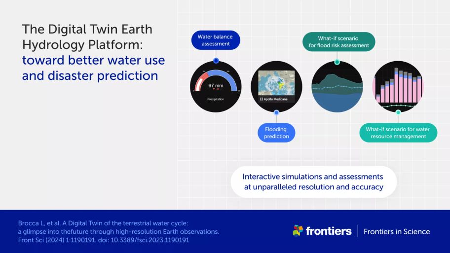
The DTE Hydrology Platform demonstrates four-dimensional simulations of five terrestrial water variables—soil moisture, precipitation, evaporation, snow depth, and river discharge—at the highest resolution and accuracy yet achieved. Some data and simulations are overlaid over satellite images, where users can zoom in and out to see more details. Other simulations provide forecasts as accompanying graphs.
The platform’s four case studies showcase practical applications, allowing users to easily visualize:
precipitation and other water anomalies in the Mediterranean Basin on different dates
the progression of two flooding events, one in Italy’s Po River valley and another in Sicily
flood risk in the Po River valley under different soil moisture and precipitation conditions
the impact of different conditions on water use in the Po River valley.
The project, which is funded by the European Space Agency (ESA), focuses on the Mediterranean Basin.
Where do the data in the DTE Hydrology Platform come from?
DTE Hydrology uses newly available high-resolution data from next-generation satellites—the first digital twin of the Earth models to do so. This "Earth observation" data has a spatial resolution of 1x1 km, 20-fold better than previously available, and a time resolution of 1 hour to 3 days. The dataset includes both direct measurements and modeled data for the five water variables mentioned above, over the period 2016 to 2022. These data are validated against "in situ" measurements from sensors and gauges on the ground, and integrated into advanced hydrological modeling systems to create the final platform. Measurements from citizen observations could also be incorporated in the future.
Why did the project start with the Mediterranean—and specifically the Po River valley?
The Mediterranean Basin experiences extreme weather events like flooding and droughts and is strongly affected by climate change. This made it a useful starting point to develop simulations for conditions of both too much and too little water.
The Po River valley in northern Italy was chosen to prototype case studies for two reasons. One is that the area includes varied features that make the water cycle challenging to simulate—from mountains with glaciers, to valleys with industry and irrigation. The second is that high-quality ground observations are available for this area, which the authors could use to validate satellite data.
What are the next steps for building a digital twin of the water cycle?
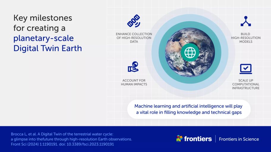
The authors list four areas of work for developing a robust digital twin Earth for hydrology that can reliably predict extreme events and aid decision-makers.
1. Enhancing the collection of accurate, high-resolution data. Future satellite missions will extend scientists’ ability to reproduce the terrestrial water cycle at high resolution. However, these new data—together with those already available in the DTE Hydrology Platform—need to be validated across different regions and climates. This is a challenge given a shortage of corresponding ground observations. Other issues include ensuring consistency between data from satellites and models and managing uncertainties and biases in both data sources.
2. Building high-resolution models. New models are needed for processes like groundwater dynamics and water runoff at local and small scales, as opposed to current models with a coarse resolution of 20 km.
3. Accounting for human impacts on the water cycle. Human activities like irrigation, reservoir management, flood protection, and diversion of river water must be integrated efficiently into modeling systems.
4. Developing powerful, user-friendly platforms. Digital twin Earths must allow all users—scientists, decision-makers, and the public—to easily interact with data and models. On top of this, the information and communications infrastructure behind the platform must have enough computational power to simulate the water cycle in high-resolution, at a continental and global scale, and in near real time. In addition, this infrastructure will ideally be a cloud-based web service that is openly available to all.
The authors highlight the vital role of artificial intelligence and machine learning in addressing these challenges. Applications include enhancing data analysis, collection, and processing speed; streamlining the assessment of data quality; and providing alternatives to data-heavy models which are slow to run and consume a lot of power.