- 1Xiamen Meteorological Service Center, Xiamen, China
- 2School of Computer and Information Engineering, Xiamen University of Technology, Xiamen, China
Utilizing hourly observational data from automatic weather stations across Fujian Province from 2008 to 2020, this study defined and classified concepts and thresholds for convective precipitation, short-duration convective precipitation, long-duration convective precipitation, localized heavy precipitation, and widespread heavy precipitation. We explored the fundamental diurnal climatic characteristics of convective precipitation during the flood season in Fujian Province’s complex terrain. The results indicate the following. 1) Convective precipitation during the flood season exhibits distinct diurnal variation, with a significant spatial distribution along mountainous and coastal terrains. 2) The frequency of precipitation during the pre-flood season is higher and its intensity is lower than in the post-flood season. Due to differing primary weather systems influencing each period, resulting in substantial differences in the spatial distribution of precipitation frequency and intensity. 3) Both short-duration and localized precipitation show pronounced afternoon peaks in their diurnal patterns, predominantly occurring on windward slopes, highlighting mechanisms of afternoon moist convection and orographic lifting, whereas long-duration and widespread precipitation lack diurnal variation, reflecting the influence of large-scale circulation. These results will help forecasters better understand the unique precipitation characteristics of Fujian Province.
1 Introduction
Fujian Province is nestled between mountains and the sea, with a terrain high in the northwest and low in the southeast. Approximately 90% of the province’s area consists of mountains and hills. The Wuyi Mountain Range traverses the northwest, while the central region features the Minzhong Mountain Belt, primarily composed of Jiu Feng, Daiyun, and Bopingling Mountains, stretching from northeast to southwest. These mountains often exceed altitudes of 1,000–1,200 m, with some peaks surpassing 1,800 m. The southeastern coastal areas are primarily plains with lower elevations (Figure 1; Xu et al., 2022).
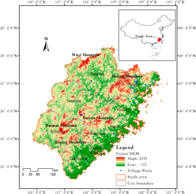
Figure 1. Topographic map of Fujian Province and the main mountain ranges [Reprinted from reference (Xu et al., 2022)].
Fujian experiences a subtropical maritime monsoon climate characterized by distinct three-dimensional climatic features and high temperatures with abundant rainfall in summer. Within this climatic framework, warm, moist sea winds from the southeast regulate the climate. At the same time, the mountainous regions in the northwest and central parts block cold air and uplift warm, moist air, creating unique precipitation patterns.
Interdecadal variations reveal alternating wet and dry periods in Fujian’s precipitation (Qin et al., 2009). Seasonally, rainfall is concentrated from March to September, with coastal and central areas displaying bimodal peaks in June and August due to the combined effects of the summer monsoon and tropical cyclones. Meanwhile, less influenced by tropical cyclones, the northwestern region exhibits a rainfall peak in June (Lin et al., 2013). Therefore, in forecasting, March to June is referred to as the pre-flood season, while July to September is the post-flood or typhoon season.
In addition to these temporal scales, the diurnal variation in precipitation is another critical topic in climate research. Due to its sensitivity to various thermal and dynamic factors (Trenberth, 1998; Trenberth et al., 2003; Yu et al., 2007a; Yu et al., 2009; Yu et al., 2014), revealing the spatial features of diurnal variations in precipitation is helpful not only for understanding the physical processes related to precipitation formation (Trenberth et al., 2003; Lin et al., 2000), but also for comprehending regional climate characteristics, which is valuable for forecasters. Research on diurnal precipitation variation also contributes to satellite data validation (Zhou et al., 2008; Xu and Zipser, 2011) and numerical model evaluation (Dai et al., 2011; Yuan et al., 2013; DeMott et al., 2007).
Summer precipitation in mainland China exhibits significant diurnal variations with distinct regional characteristics (Yu et al., 2007a). Numerous studies have investigated the diurnal patterns of precipitation across various regions (Yu et al., 2014; Shen and Zhang, 2011; Yu and Li, 2016; Dai et al., 2009; Liu et al., 2023), The eastern Tibetan Plateau and Sichuan Basin feature a midnight peak, while the middle reaches of the Yangtze River experience an early morning peak and Eastern China shows a dual-peak pattern in the early morning and afternoon. Diurnal variations in the amount, frequency, and intensity of rainfall over southern China exhibit substantially different amplitudes from southwestern to southeastern China (Jiang et al., 2016). Many studies have also utilized satellite precipitation data (Mao et al., 2012; Bai et al., 2008) and ERA reanalysis precipitation data (Chow and Chan, 2009). However, a gap exists between these data results and actual observational data. Several studies (Yu et al., 2009; Yu et al., 2007b; Yuan et al., 2010; Yin et al., 2011) have utilized long-term national-level station data with relatively low network density for provincial regions. With the increasing need for a detailed understanding of precipitation processes, it is essential to conduct higher spatial resolution diurnal variation analyses using denser observation networks to improve the understanding of regional weather and climate.
Conversely, Fujian Province’s complex terrain and diverse weather systems result in various types of precipitation, especially during the flood season. Therefore, it is necessary to conduct systematic research using data from dense observation networks. One study (Zhang et al., 2017) investigated the spatial features and diurnal variation of precipitation amount (PA), precipitation frequency (PF), and precipitation intensity (PI), and they found that notable regional differences in diurnal precipitation cycles over Fujian Province can be observed between coastal, valley, hilly, and mountainous areas. On this basis, we defined different types of convective precipitation in this study and, considering the intricate topography, we analyzed their respective diurnal variation characteristics in terms of frequency, intensity, and spatial distribution. In addition, the diurnal variations of related surface meteorological elements were examined, laying the foundation for categorizing and understanding the precipitation mechanisms during the Fujian Province flood season.
2 Materials and methods
2.1 Data and definitions
The data utilized in this study included hourly precipitation records from automated weather stations across Fujian Province from 2008 to 2020. The data underwent quality control, initially excluding stations with more than 5% missing measurements and subsequently omitting those with less than 2 years of precipitation data. As a result, the number of valid stations each year has been as follows: 357 stations in 2008, 776 stations in 2009, 1,053 stations in 2010, 1,130 stations in 2011, 1,196 stations in 2012, 1,521 stations in 2013, 1,673 stations in 2014, 1,691 stations in 2015, 1,699 stations in 2016, 2,078 stations in 2017, 2,114 stations in 2018, 2,084 stations in 2019, and 2021 stations in 2020.
The definitions are as follows.
(1) Precipitation is considered to have occurred when the actual rainfall is 0.1 mm or more.
(2) Convective precipitation is defined as single-station rainfall exceeding 10 mm/h.
(3) Convective precipitation frequency: The ratio of the number of convective precipitation occurrences at that time to the total number of such occurrences within the statistical period.
(4) Convective precipitation intensity: The ratio of cumulative precipitation to the number of convective precipitation instances during that time slot.
(5) Pre-flood and post-flood seasons: In this context, the pre-flood season in Fujian Province refers to March through June, and the post-flood season refers to July through September.
(6) Short-duration (long-duration) convective precipitation: Convective precipitation lasting less than or equal to 6 h (or more than 6 h) is classified as short-duration (or long-duration) convective precipitation.
(7) Regional localized heavy precipitation and widespread systemic precipitation: Based on the definition of convective precipitation, single-station precipitation exceeding 20 mm/h is classified as regional localized heavy precipitation. When 20% of stations experience convective precipitation at a given time, it is considered widespread systemic precipitation.
2.2 Computational analysis methods
Calculating single-station averages involves taking the arithmetic mean of hourly data over the relevant period for each station. The arithmetic mean of all regional stations at a specific time was used without any weighted average for regional averages. For instance, in 2008, the arithmetic mean of the hourly occurrence frequency (intensity) of convective precipitation across all stations was defined as the diurnal variation of the annual convective precipitation frequency (intensity).
Method for selecting different duration precipitation: First, we identified the long-duration convective precipitation for each station. After removing the long-duration convective precipitation from the total, the short-duration convective precipitation was obtained.
3 General characteristics of convective precipitation
Our analysis of the diurnal variation in convective precipitation frequency and intensity from 2008 to 2020, annually and averaged over 13 years (Figure 2), revealed a consistent yearly trend. The frequency of convective precipitation shows two peaks: a strong peak occurring from afternoon to evening between 15:00 and 20:00, with the highest frequency at 17:00, and a weaker peak at approximately 08:00 in the morning (Figure 2A). The precipitation intensity shows a single peak between 16:00 and 18:00 (Figure 2B). This analysis indicates that convective precipitation in Fujian Province predominantly occurs from afternoon to evening, during which the intensity is also at its maximum for the day.

Figure 2. Diurnal variation in annual average convective precipitation in Fujian Province from 2008 to 2020: (A) precipitation frequency (%); (B) precipitation intensity (mm/h).
Regarding the spatial distribution of convective precipitation frequency and intensity (Figure 3A), areas with high precipitation frequency are primarily located near the windward slopes east of the Wuyi Mountains and the central mountain ranges of Fujian. This suggests that the southeast monsoon and typhoons during summer and autumn significantly affect the precipitation patterns, with moisture from the southeastern seas being uplifted by the terrain, resulting in more convective rainfall on the eastern sides of these mountain ranges. The center of precipitation intensity is situated at the junction of the coastal plains and mountainous regions in eastern Fujian (Figure 3B). Besides the orographic lifting mechanism, typhoon precipitation likely makes an important contribution to the overall precipitation patterns.
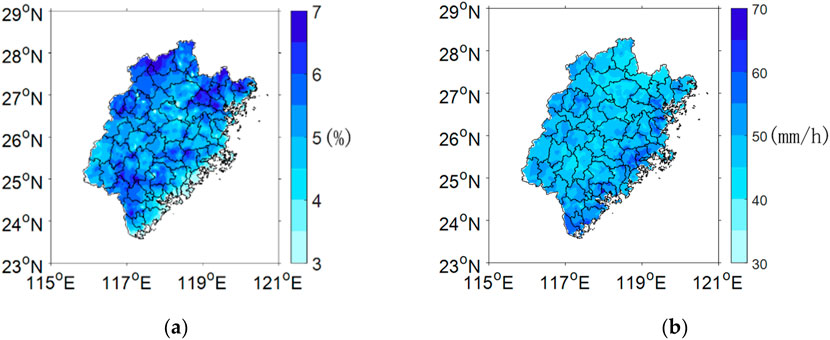
Figure 3. Spatial distribution of the 13-year average convective precipitation in Fujian Province: (A) precipitation frequency (%); (B) precipitation intensity (mm/h).
Building on the general characteristics of the spatial distribution of precipitation, we further explored the spatial features of precipitation frequency and intensity across different periods (as shown in Supplementary Figures A1, A2). Regarding precipitation frequency, from 00:00 to 12:00, convective precipitation was minimal, with larger centers concentrated on the eastern sides of the northwestern and northeastern mountains of Fujian. Starting at 14:00, there was a significant increase in precipitation frequency, with high-value areas aligning with the orientation of several major mountain ranges. By 16:00, the frequency of convective precipitation increased further throughout Fujian. From 20:00, the frequency began to decline, with high-value areas gradually concentrating along the mountainous northern regions of Fujian. Regarding precipitation intensity, from 00:00 to 12:00, sporadic high-value areas were distributed across Fujian. By 14:00, high-intensity centers became more prominent along the southeastern coast. At 18:00, these centers further intensified and increased in the coastal plains and foothills in the east. By 20:00, the intensity diminished and became more dispersed.
4 Characteristics of different types of convective precipitation
4.1 Analysis of convective precipitation characteristics of different durations
The duration of precipitation is a crucial factor in measuring the spatiotemporal variations of rainfall. Precipitation of varying durations may result from weather systems operating on different temporal scales. Studying the spatiotemporal characteristics and trends of precipitation for different durations helps us understand the influencing factors and formation mechanisms across various time scales (Jin et al., 2015). Yu et al. (2007a) categorized warm-season precipitation in eastern China into long-duration (>6 h) and short-duration events, and they discovered significant spatial distribution differences between these categories and hypothesized that distinct physical mechanisms might generate precipitation of varying durations.
In Fujian Province, as shown in Figure 4, there is a considerable difference in frequency and intensity between long-duration and short-duration convective precipitation. Long-duration convective precipitation exhibits an inconspicuous diurnal variation with gentle peaks (Figures 4A, C), showing a minor peak at approximately 08:00, with lower average precipitation frequency but higher average precipitation intensity. Conversely, short-duration convective precipitation displays pronounced diurnal variation, with peaks in both frequency and intensity occurring at approximately 16:00–17:00, featuring a higher average precipitation frequency and relatively lower average precipitation intensity (Figures 4B, D).
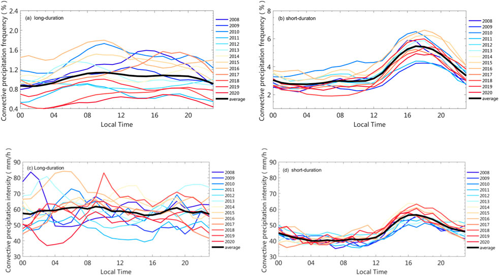
Figure 4. Diurnal variation in annual average convective precipitation in Fujian Province: (A) frequency of long-duration convective precipitation (%); (B) frequency of short-duration convective precipitation (%); (C) intensity of long-duration convective precipitation (mm/h); (D) intensity of short-duration convective precipitation (mm/h).
In terms of spatial distribution, the frequency of both long-duration and short-duration precipitation shows a similar pattern to the overall frequency of convective precipitation (Figure 3A), with high-value areas primarily located in the Wuyi Mountains and the eastern parts of the central Fujian mountains (Figures 5A, B). The high-value regions for long-duration precipitation intensity are mainly along the eastern coast, mirroring the spatial distribution of the overall intensity of convective precipitation (Figure 3B). By contrast, short-duration precipitation intensity is generally weaker.
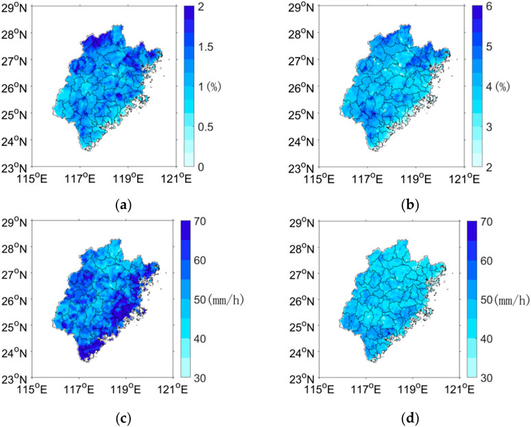
Figure 5. Spatial distribution of the 13-year average frequency of convective precipitation in Fujian Province: (A) frequency of long-duration convective precipitation (%); (B) frequency of short-duration convective precipitation (%); (C) intensity of long-duration convective precipitation (mm/h); (D) intensity of short-duration convective precipitation (mm/h).
Overall, only short-duration precipitation exhibits a pronounced diurnal variation, indicating that afternoon thermal convection is likely the primary trigger mechanism. The frequency of short-duration convective precipitation in Fujian Province is significantly higher, suggesting that the primary form of rainfall during the flood season is short-duration showers. This finding aligns with previous research, which noted that short-duration events constitute a larger proportion of heavy rainfall events in the summer across central and eastern China (Jin et al., 2015). Some studies on the spatial-temporal distribution characteristics of typhoon rainstorm in Fujian Province (He et al., 2019; Author Anonymous, 2008; Lu and Wang, 2013) show that typhoon precipitation in Fujian province occurs most in August, the multi-year average typhoon rainstorm days and daily typhoon rainstorm precipitation both gradually decreased from the eastern coastal region to the northwestern inland region of Fujian, the maximum typhoon precipitation occurs in the northeastern and the southern coast. However, in our research, the greater intensity of long-duration precipitation, with high-value areas also mainly along the eastern coast, so we think that typhoon may be make significant contributions to long-duration precipitation.
4.2 Analysis of convective precipitation characteristics across different spatial scales
The spatial scale of precipitation refers to the extent of the continuous rain area, which is closely linked to the mechanisms and physical processes of precipitation formation, representing an essential characteristic of rainfall. In this paper, regional heavy rainfall primarily signifies convective rain within a limited area, such as a single city or county. By contrast, large-scale systemic rainfall involves multiple cities or entire provinces, such as frontal rain or jet stream-induced rain.
In Fujian Province, regional heavy rainfall exhibits a distinct afternoon peak, indicative of diurnal variation (Figures 6A, B), suggesting that afternoon thermal convection is a principal triggering mechanism. This is consistent with previous studies showing that Southeastern China is dominated by afternoon rainfall caused by surface heating, likely aided by local topographical lifting (Jiang et al., 2016). The frequency maxima are prominently distributed along major mountain ranges (Figure 7A), highlighting the significant role of orographic uplift in regional heavy rainfall. The distribution characteristics of intensity (Figure 7B) are similar to the general distribution characteristics of convective precipitation (Figure 3B), with the center located at the junction of the coastal plain and mountainous areas in eastern Fujian. Large-scale systemic rainfall shows considerable interannual variability with no pronounced diurnal pattern and generally weaker peaks (Figures 8A, B).

Figure 6. Diurnal variation in annual average regional heavy rainfall in Fujian Province: (A) frequency of regional heavy rainfall (%); (B) intensity of regional heavy rainfall (mm/h).
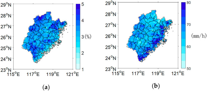
Figure 7. Spatial distribution of regional heavy rainfall in Fujian Province: (A) frequency of regional heavy rainfall (%); (B) intensity of regional heavy rainfall (mm/h).

Figure 8. Diurnal variation in annual average large-scale systematic precipitation in Fujian Province: (A) frequency of large-scale systematic precipitation (%); (B) intensity of large-scale systematic precipitation (mm/h).
Only localized heavy rainfall shows obvious diurnal variation, while large-scale rainfall shows minimal diurnal change, likely due to differing triggering mechanisms. Large-scale convective rainfall is typically associated with broad-scale circulations like fronts, typhoons, and southerly jets. By contrast, localized convective rainfall is primarily driven by solar radiation-induced afternoon moist convection, further influenced by orographic lifting, influencing the precipitation intensity.
4.3 Analysis of convective precipitation characteristics across different seasons
The pre-flood season in Fujian Province typically begins in April, peaks in May, and usually concludes in late June, with the average on 26 June, corresponding with the northward extension of the subtropical high pressure. During this period, the subtropical high pressure ridge line jump north to around 16°∼20°N, and frequent frontal trough appear from southern Jiangnan to southern China, the southerly low-level jet stream was established, they are all important weather systems that contribute to the precipitation during the pre flood season in Fujian Province. According to statistics from 1971 to 2,000, typhoons affecting Fujian are primarily concentrated between July and September (Lin et al., 2013; Lu and Wang, 2013). Thus, the post-flood season is also called the typhoon season (Lu and Wang, 2013). In addition to the impact of typhoons, the precipitation during the post flood season is mainly unstable precipitation caused by weak cold air infiltration along the coast under the control of subtropical high pressure.
The predominant weather systems influencing the early and late flood seasons differ, resulting in distinct precipitation characteristics. According to the statistical data of rainstorm days in Fujian Province (Lin et al., 2013), rainstorm occurs all from January to December in Fujian Province, but most of them are concentrated in March to September. The monthly distribution presents a bimodal pattern, in addition to the rainstorm peak in the rainy season, there is another rainstorm peak in August affected by tropical cyclones. Therefore, we analyzed the convective precipitation features for both periods. The findings reveal that rainfall is most frequent during the pre-flood flood season (Figure 9A), predominantly in inland areas, especially the northwestern mountainous regions (Figure 10A), without major intensity centers (Figure 10C). By contrast, during the post-flood season, the rainfall center shifts to the windward slopes east of the central mountains (Figure 10B), with a significantly higher intensity (Figure 9B), primarily concentrated along the eastern coast (Figure 10D), highlighting the contribution of typhoon-related precipitation.

Figure 9. Diurnal variations in annual average convective precipitation in Fujian Province (Blue: pre-flood season, Red: post-flood season): (A) frequency of convective precipitation; (B) intensity of convective precipitation.
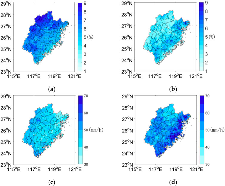
Figure 10. Spatial distribution of the 13-year average convective precipitation in Fujian Province: (A) frequency of convective precipitation during the pre-flood season (%); (B) frequency of convective precipitation during the post-flood season (%); (C) intensity of convective precipitation during the pre-flood season (mm/h); (D) intensity of convective precipitation during the post-flood season (mm/h).
As illustrated in Figure 11, the diurnal variation in wind direction during the flood seasons shows that nocturnal winds are mainly northerly and northeasterly, while daytime winds, particularly in the afternoon, are primarily southeasterly, southerly, and southwesterly (Figures 11A, B). This indicates the unique land–sea breeze in coastal areas, the sea breeze has also been proven to cause low-level convergence,which partially results the maximum precipitation in the afternoon over land (Tang et al., 2019). Therefore, we believe that the land–sea breezes has a significant impact on diurnal variation of wind direction in Fujian Province, and the diurnal variation of precipitation. On the other hand, many studies have shown that complex terrain also has influence on the formation and development of cloud and precipitation (Li et al., 2024; Houze, 2012; Li et al., 2022). Turbulent orographic form drag related to complex terrain has been investigated to affect precipitation through dynamical and microphysical processes, it can enhance low-level convergence and high-level divergence, thereby strengthening updraft and precipitation processes (Li et al., 2024; Houze, 2012). Moreover, this effect is more apparent during the daytime (Houze, 2012). Besides, deep convective events can produce extreme local rainfall and flooding when they occur near mountain ranges, and mountains affect diurnal cycles of convective precipitation via the upslope/downslope wind reversal associated with the daily cycle of heating and cooling (Li et al., 2022). Based on these research findings, we believe that the higher relative humidity in the pre-flood season (shown in Supplementary Figure A3) makes saturation more likely, with a higher frequency of easterly and southerly winds (Figure 11A), at the same time, with the cooperation of mountain uplift, convective precipitation is more frequent, consistent with our earlier conclusion. Temperature-wise, the late flood season experiences noticeably higher temperatures (shown in Supplementary Figures A4A, B), which likely favor stronger convection, thus affecting the intensity of convective precipitation. According to climate research in Fujian Province (Lin et al., 2013; Lu and Wang, 2013), the average total precipitation in the eastern coastal areas is around 600–700 mm during the post flood season, with typhoon precipitation contributing the most, reaching 350–500 mm. Typhoon precipitation in various coastal cities accounts for about 60% of the post-flood season precipitation. Hence, the greater precipitation intensity during the post-flood season could be partially attributed to typhoon contributions and elevated temperatures.
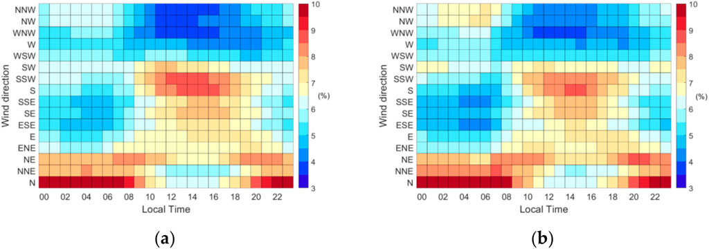
Figure 11. Diurnal variation in the frequency of the 10-min wind direction: (A) pre-flood season in Fujian Province; (B) post-flood season in Fujian Province.
4.3.1 Spatiotemporal characteristics of convective precipitation with different durations under various seasonal conditions
Building on the analysis of convective precipitation characteristics during the pre- and post-flood seasons, we further examined the spatiotemporal distribution features of short-duration and long-duration rainfall under different seasonal conditions.
Similar to the overall flood season precipitation characteristics, both the pre-flood and post-flood periods are dominated by short-duration rainfall, with long-duration rainfall exhibiting greater intensity. Notably, besides the strong typhoon-induced precipitation along the eastern coast during the post-flood season (Figure 12B), significant centers of long-duration rainfall intensity are also observed in the western mountainous regions and along the southern coast during the pre-flood season (Figure 12A), likely associated with frontal precipitation. This suggests that, in addition to the need for vigilance against typhoon-related long-duration heavy rainfall during the post-flood season, it is equally important to be alert to prolonged intense rainfall events in the western mountains and southern coastal areas during the pre-flood season.
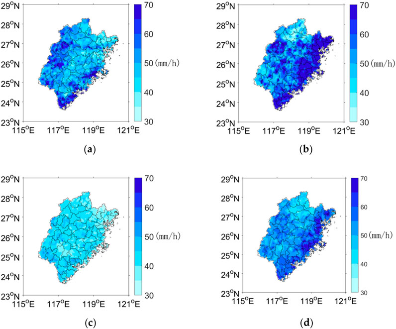
Figure 12. Spatial distribution of convective precipitation in Fujian Province (mm/h): (A) intensity of long-duration rainfall during the pre-flood season; (B) intensity of long-duration rainfall during the post-flood season; (C) intensity of short-duration rainfall during the pre-flood season; (D) intensity of short-duration rainfall during the post-flood season.
However, the intensity of short-duration rainfall is significantly stronger during the post-flood season compared with that during the pre-flood season (Figures 12C, D), highlighting the more pronounced and intense afternoon convective activity in Fujian Province during the post-flood period.
4.3.2 Spatial and temporal characteristics and possible causes of convective precipitation across different spatial scales under various seasonal conditions
Our comparison of diurnal variation characteristics under different seasonal conditions revealed that the peak frequency of regional heavy rainfall occurs at 18:00 during the pre-flood season and at 17:00 during the post-flood season, advancing by 1 h (Figure 13A). Moreover, air temperature and surface temperature are significantly higher in the post-flood season by more than 4°C (Supplementary Figures A4A, B), with elevated temperatures more likely to trigger convective activity earlier. To verify the speculation, we have further analyzed the convective available potential energy (CAPE) data from 2008 to 2020, which based on hourly data from ERA5 reanalysis data, and the results showed that the average CAPE of Fujian Province region during the post flood season was significantly about three times higher than that during the pre flood season (Supplementary Figure A5). Thus, we suggest that the higher temperatures and higher unstable energy in the post-flood season may contribute to the earlier occurrence of regional heavy rainfall.

Figure 13. Diurnal variation in the frequency of convective precipitation (blue: pre-flood season; red: post-flood season): (A) regional heavy rainfall; (B) large-scale systematic precipitation.
The diurnal variation characteristic of widespread convective rainfall is relatively weak during the post-flood seasons, but with an afternoon peak in the pre-flood season (Figure 13B). This indicates that systematic precipitation accounts for a larger proportion of widespread convective rainfall, particularly in the post-flood season.
5 Conclusion and discussion
This study comprehensively examined the diurnal variations in convective precipitation during the flood season in Fujian Province under complex terrain conditions, Further refined and improved the research on convective precipitation in Fujian Province, which will help forecasters better understand and master precipitation characteristics. Convective precipitation predominantly occurring from afternoon to evening, with peak intensity between 17:00 and 18:00. We believe that intricate topography significantly influences the spatial distribution of convective precipitation. High-frequency rainfall centers are located near the windward slopes east of the Wuyi Mountains and Minzhong Mountain range, where the terrain uplifts maritime moisture. The intensity center is at the convergence of coastal plains and mountains in eastern Fujian, suggesting that typhoon-induced precipitation also plays a crucial role in this region.
We defined and distinguished different types of convective precipitation, there are notable differences in frequency and intensity between long-duration and short-duration convective precipitation, localized heavy rain and large-scale precipitation. Short-duration rainfall has a higher frequency than long-duration, and shows noticeable diurnal characteristics, indicating that brief, convective showers driven by afternoon thermal convection dominate the flood season. Long-duration precipitation is more intense and predominantly occurs in eastern coastal areas, likely influenced by typhoons. On the otherhand, localized intense rainfall displays a clear afternoon peak in its diurnal cycle, with high-frequency centers distributed along major mountain ranges, also indicating that afternoon thermal convection and orographic uplift are pivotal mechanisms for regional heavy rainfall formation. By contrast, large-scale precipitation events exhibit significant interannual variability but weak diurnal variation, suggesting they are primarily associated with synoptic-scale circulations, such as fronts, typhoons, and southerly jets.
We also explored the differences in convective precipitation in different seasons, pre-flood season convective precipitation is more frequent and concentrated inland, influenced by higher relative humidity, prevailing easterly and southeasterly winds, and orographic effects. Post-flood season precipitation is more intense, mainly over eastern coastal areas, facilitated by higher temperatures that enhance convection, alongside contributions from typhoon precipitation. Therefore, in forecasting operations, attention must be given to the prolonged intense precipitation caused by typhoons in the post-flood season and to sustained heavy rainfall events in the western mountainous regions and southern coastal areas during the pre-flood season. We found that localized intense rainfall peaks approximately 1 h earlier in the pre-flood season than in the post-flood season, with post-flood temperatures exceeding pre-flood levels by more than 4°C, triggering thermal convection earlier. Thus, elevated temperatures are likely a factor in the advanced diurnal peak of regional intense rainfall in the post-flood season. Large-scale convective precipitation shows weak diurnal variation in both pre- and post-flood seasons, further indicating a predominance of systematic precipitation, particularly in the post-flood season.
Based on a preliminary diagnostic analysis of observation data from ground-based meteorological stations, this study offers limited explanations regarding the spatiotemporal distribution characteristics of precipitation that rely on forecasting expertise for potential hypotheses regarding the causes. Further analysis and discussion incorporating historical case studies, circulation patterns, influencing systems, vertical dynamical structures, and topographical factors are needed to develop conceptual models.
Data availability statement
The raw data supporting the conclusions of this article will be made available by the authors, without undue reservation.
Author contributions
QW: Conceptualization, Data curation, Formal Analysis, Methodology, Supervision, Writing–original draft, Writing–review and editing. JT: Investigation, Project administration, Supervision, Writing–original draft, Writing–review and editing. YZ: Conceptualization, Data curation, Resources, Supervision, Visualization, Writing–original draft, Writing–review and editing. YL: Formal Analysis, Funding acquisition, Resources, Software, Validation, Visualization, Writing–original draft, Writing–review and editing.
Funding
The authors declare that financial support was received for the research, authorship, and/or publication of this article. This research was funded by Innovation and Development Special Project of China Meteorological Administration (CXFZ2024J069), the National Natural Science Foundation of China (NSFC) (41805028), the Green and Intelligent Ship in the Fujian region (CBG4N21-4-4), Research on Forecasting Technology for Adverse Weather Effects such as Low Visibility and Strong Winds (BW230315-016).
Conflict of interest
The authors declare that the research was conducted in the absence of any commercial or financial relationships that could be construed as a potential conflict of interest.
Publisher’s note
All claims expressed in this article are solely those of the authors and do not necessarily represent those of their affiliated organizations, or those of the publisher, the editors and the reviewers. Any product that may be evaluated in this article, or claim that may be made by its manufacturer, is not guaranteed or endorsed by the publisher.
Supplementary material
The Supplementary Material for this article can be found online at: https://www.frontiersin.org/articles/10.3389/feart.2024.1469871/full#supplementary-material
References
Author Anonymous (2008). Climatological variation features of typhoon precipitation influencing Fujian for the past 46 years. Trop. Meteorol. 14 (2), 161–164.
Bai, A. J., Liu, C. H., Liu, X. D., et al. (2008). Diurnal variation of summer rainfall over the Tibetan Plateau and its neighboring regions revealed by TRMM multi-satellite precipitation analysis. Chin. J. Geophys. 51 (3), 704–714. doi:10.3321/j.issn:0001-5733.2008.03.011
Chow, K. C., and Chan, J. C. L. (2009). Diurnal variations of circulation and precipitation in the vicinity of the Tibetan Plateau in early summer. Clim. Dyn. 32 (1), 55–73. doi:10.1007/s00382-008-0374-x
Dai, Z. J., Yu, R. C., and Chen, H. M. (2009). Characteristics of summer precipitation diurnal variations in Hunan. Plateau Meteor 28 (6), 1463–1470. doi:10.1016/S1003-6326(09)60084-4
Dai, Z. J., Yu, R. C., Li, J., et al. (2011). The characteristics of summer precipitation diurnal variations in three reanalysis datasets over China. Meteor Mon. 37 (1), 20–31. doi:10.1007/s00376-010-0052-x
DeMott, C. A., Randall, D. A., and Khairoutdinov, M. (2007). Convective precipitation variability as a tool for general circulation model analysis. J. Clim. 20, 91–112. doi:10.1175/jcli3991.1
He, Z., Zheng, Q., Xu, C., et al. (2019). Study on temporal and spatial characteristics of typhoon rainstorm in fujian province from 1960 to 2013. Renmin Zhujiang 40 (3), 1–8. doi:10.3969/j.issn.1001-9235.2019.03.001
Houze, R. A. (2012). Orographic effects on precipitating clouds. Rev. Geophys. 50 (1). doi:10.1029/2011rg000365
Jiang, Z., Zhang, D. L., Xia, R., and Qian, T. (2016). Diurnal variations of pre-summer rainfall over southern China. J. Clim. 30 (2), 755–773. doi:10.1175/jcli-d-15-0666.1
Jin, W., Li, W., Sun, C., et al. (2015). Spatiotemporal characteristics of summer precipitation with different durations in central east China. Clim. Environ. Res. 20 (4), 465–476. doi:10.3878/j.issn.1006-9585.2015.14268
Li, G. D. Z., Chen, H. M., Xu, M. Y., Zhao, C., Zhong, L., Li, R., et al. (2022). Impacts of topographic complexity on modeling moisture transport and precipitation over the Tibetan plateau in summer. Adv. Atmos. Sci. 39 (7), 1151–1166. doi:10.1007/s00376-022-1409-7
Li, J., Lu, C., Chen, J., Zhou, X., Yang, K., et al. (2024). The influence of complex terrain on cloud and precipitation on the foot and slope of the southeastern Tibetan Plateau. Clim. Dyn. 62, 3143–3163. doi:10.1007/s00382-023-07056-3
Lin, X., Liu, A., Lin, Y., et al. (2013). Technical manual of weather forecasting in Fujian Province. 2. Beijing, China: Publisher, 11–16.
Lin, X., Randall, D. A., and Fowler, L. D. (2000). Diurnal variability of the hydrologic cycle and radiative fluxes: comparisons between observations and a GCM. J. Clim. 3 (23), 4159–4179. doi:10.1175/1520-0442(2000)013<4159:dvothc>2.0.co;2
Liu, F., Zheng, Y., Luo, Q., et al. (2023). Comparison of characteristics of light precipitation and short-time heavy precipitation over Beijing, Tianjin, Hebei and neighbouring areas. J. Appl. Meteorol. Sci. 34 (5), 619–629. doi:10.11898/1001-7313.20230510
Lu, S., and Wang, Y. (2013). The climate of Fujian. 2nd ed. Beijing, China Meteorological Press: Publisher, 138–141.
Mao, J. Y., Wu, G. X., et al. (2012). Diurnal variations of summer precipitation over the Asian monsoon region as revealed by TRMM satellite data. Sci. China 55, 554–566. doi:10.1007/s11430-011-4315-x
Qin, L., Huang, H., and Zhang, L. (2009). “Study on precipitation climate characteristics in fujian province over the past 50 years,” in Proceedings of the 26th annual meeting of the Chinese meteorological society, 682–686.
Shen, P. F., and Zhang, Y. C. (2011). Numerical simulation of diurnal variation of summer precipitation in Sichuan Basin. Plateau Meteorol. 30 (4), 860–868. doi:10.3724/SP.J.1146.2006.01085
Tang, X., Cai, Q., Fang, J., and Tan, Z. M. (2019). Land–sea contrast in the diurnal variation of precipitation from landfalling tropical cyclones. J. Geophys. Res. Atmos. 124 (22), 12010–12021. doi:10.1029/2019jd031454
Trenberth, K. E. (1998). Atmospheric moisture residence times and cycling: implications for rainfall rates and climate change. Clim. Change 39 (4), 667–694. doi:10.1023/a:1005319109110
Trenberth, K. E., Dai, A. G., Rasmussen, R. M., and Parsons, D. B. (2003). The changing character of precipitation. Bull. Amer. Meteor. Soc. 84 (9), 1205–1218. doi:10.1175/bams-84-9-1205
Xu, W. X., and Zipser, E. J. (2011). Diurnal variations of precipitation, deep convection, and lightning over and east of the eastern Tibetan Plateau. J. Clim. 24 (2), 448–465. doi:10.1175/2010jcli3719.1
Xu, X., Genovese, P. V., Zhao, Y., Liu, Y., Woldesemayat, E. M., and Zoure, A. N. (2022). Geographical distribution characteristics of Ethnic-Minority villages in Fujian and their relationship with topographic factors. Sustainability 14 (13), 7727. doi:10.3390/su14137727
Yin, S., Li, W., Chen, D., Jeong, J. H., and Guo, W. (2011). Diurnal variations of summer precipitation in the Beijing area and the possible effect of topography and urbanization. Adv. Atmos. Sci. 28, 725–734. doi:10.1007/s00376-010-9240-y
Yu, R. C., Li, J., Chen, H. M., et al. (2014). Progress in studies of the precipitation diurnal variation over contiguous China. J. Meteorol. Res. 72 (5), 21. doi:10.11676/qxxb2014.047
Yu, R. C., Li, J., and Cheu, H. (2009). Diurnal variation of surface wind over central Eastern China. Clim. Dyn. 33 (7-8), 1089–1097. doi:10.1007/s00382-008-0478-3
Yu, R. C., and Li, J. (2016). Regional characteristics of diurnal peak phases of precipitation over contiguous China. Acta Meteorol. Sin. 74 (1), 18–30.
Yu, R. C., Xu, Y. P., Zhou, T. J., and Li, J. (2007a). Relation between rainfall duration and diurnal variation in the warm season precipitation over central Eastern China. Geophys. Res. Lett. 34 (13), L13703. doi:10.1029/2007gl030315
Yu, R. C., Zhou, T., Xiong, A., Zhu, Y., and Li, J. (2007b). Diurnal variations of summer precipitation over contiguous China. Geophys. Res. Let-ters 34 (1), 223–234. doi:10.1029/2006gl028129
Yuan, W. H., Yu, R. C., Chen, H., Li, J., and Zhang, M. (2010). Subseasonal characteristics of diurnal variation in summer monsoon rainfall over central eastern China. J. Clim. 23 (24), 6684–6695. doi:10.1175/2010jcli3805.1
Yuan, W. H., Yu, R. C., Zhang, M. H., Lin, W., and Fu, Y. (2013). Diurnal cycle of summer precipitation over subtropical East Asia in CAM5. J. Clim. 26 (10), 3159–3172. doi:10.1175/jcli-d-12-00119.1
Zhang, W., Huang, A., Zhou, Y., Yang, B., Fang, D., Zhang, L., et al. (2017). Diurnal cycle of precipitation over Fujian Province during the pre-summer rainy season in southern China. Theor. Appl. Climatol. 130, 993–1006. doi:10.1007/s00704-016-1927-2
Keywords: convective precipitation, complex terrain, diurnal variation, flood season, Fujian Province
Citation: Wang Q, Tang J, Zhang Y and Li Y (2024) Diurnal variation of convective precipitation during the flood season in Fujian Province, China. Front. Earth Sci. 12:1469871. doi: 10.3389/feart.2024.1469871
Received: 24 July 2024; Accepted: 13 September 2024;
Published: 26 September 2024.
Edited by:
Xiaodong Tang, Nanjing University, ChinaReviewed by:
Chunsong Lu, Nanjing University of Information Science and Technology, ChinaQianrong Ma, Yangzhou University, China
Copyright © 2024 Wang, Tang, Zhang and Li. This is an open-access article distributed under the terms of the Creative Commons Attribution License (CC BY). The use, distribution or reproduction in other forums is permitted, provided the original author(s) and the copyright owner(s) are credited and that the original publication in this journal is cited, in accordance with accepted academic practice. No use, distribution or reproduction is permitted which does not comply with these terms.
*Correspondence: Yuxuan Zhang, NTIzMzkwMTI0QHFxLmNvbQ==
 Qianyun Wang
 Junlin Tang1
 Yuxuan Zhang