- 1Northeast Institute of Geography and Agroecology, Chinese Academy of Sciences, Changchun, China
- 2School of Architecture, Tsinghua University, Beijing, China
- 3School of Architecture and Urban Planning, Jilin Jianzhu University, Changchun, China
- 4School of Geographical Sciences, Northeast Normal University, Changchun, China
- 5College of Resources and Environment, University of Chinese Academy of Sciences (UCAS), Beijing, China
In the context of rural depopulation, spatial reorganization of settlements is widely recognized as a critical strategy to alleviate the human-land contradiction and enhance land use efficiency in the black-soil region. Using Yushu County as a case study, this paper explores an approach to the spatial optimization of urban–rural settlements in the black soil region. Currently, the urban–rural settlement system exhibits a distorted structure characterized by an excess of small settlements and a scarcity of large and medium-sized settlements, while the rank-size curve illustrates the phenomenon of “raising head, craning neck and drooping tail.” Rural development potential displays a pronounced high-high and low-low aggregation pattern. In light of this, the consolidation of settlements should be implemented at two scales: administrative villages and towns. In areas with high potential for rural development, merging natural settlements into the central settlement within an administrative village is recommended. In areas with low potential for rural development, the relocation and consolidation of natural settlements should be guided by the ideal service radius of central settlements within a town. This approach could preserve the original social relations to the greatest extent, thus facilitating the effective implementation of rural restructuring strategies.
1 Introduction
The black soil region, as a major agglomeration of the world’s high-quality cropland and a key base for the supply of commercial grains, plays a pivotal role in guaranteeing global grain security and safeguarding the life and health of human beings (Godfray et al., 2010). However, in recent years, with the advancement of urbanization, a large-scale rural population has migrated to central cities, and the black soil region has witnessed a widespread phenomenon of “demographic exodus and rural hollowing” (Zang et al., 2020; Wang et al., 2021), which undermines the urban–rural system and the human-land relations in the black-soil region, posing challenges to the protective utilization of black-soil land. Therefore, it is critical to explore the geographic specificity of the evolution of the urban–rural settlement system and its restructuring pattern. Such an exploration can promote the coordinated development of human-land relations and the efficient utilization of land resources in the black soil region.
Rural settlements serve as critical spatial carriers providing habitation for villagers, and enabling them to engage in agricultural production, and they act as the bond of interaction between villagers and land (Cloke, 2013; Yang et al., 2016). Restructuring rural settlement is naturally regarded as an efficient approach to reshaping the rural human-land relations (Sun et al., 2022). With the advancement of industrialization and urbanization in the 1970s, rural decline has become a common global challenge, such as rural depopulation in Europe, rural sparsification in Japan, and agricultural recession in Korea (Andrzej, 1992; Garcia and Ayuga, 2007; Lobley and Potter, 2004; Yukihiko, 2007). To address these challenges and promote the sustainable development of rural areas, countries began to rely on optimization of rural settlements to stimulate the endogenous development dynamics of rural areas, including Heisei Mergence in Japan, the New Village Movement in Korea (Hong et al., 2022), the Agricultural and Rural Development Act in Canada (Lapping and Fuller, 1985) and the Rural Development Program in Britain (Dwyer and Powell, 2016). In these counties, the spatial optimization of settlement systems roughly complies with three principles derived from Central Place Theory (Christaller, 1966), i.e., market, transportation and administration under the background of special geographic functions. As the practice has proved, rural settlement restructuring is a positive response to rural decline, and it is capable to block the processes of rural socio-economic recession in rural areas by reshaping the spatial structure of the countryside and production-habitation relations (Li et al., 2018; Long, 2014; Zhou et al., 2020).
Similar to developed counties, China also undergoes large-sale outflows of rural population (Hu et al., 2023; Liu et al., 2024), which brings about disorderly village-town system (Sun et al., 2013; Li L. et al., 2020; Li Y. et al., 2020) and severe human-land separation in rural areas, such as homestead hollowing, cropland abandonment, and environmental deterioration (Li et al., 2021; Qu et al., 2021). To revive the countryside, the central government of China issued Rural Revitalization Strategy Planning (2018–2022) in 2017 (Kong et al., 2021), which explicitly proposed the goal of rural revitalization by classification. A prerequisite for the implementation of the plan is to correctly grasp the evolutionary characteristics, patterns and tendencies of rural settlements in the context of rural depopulation (Chen et al., 2022; Zou et al., 2024). Thereafter, scholars have conducted numerous theoretical and empirical studies on rural hollowing, including the life cycle of hollow villages, the spatiotemporal trajectory of hollow villages, identification of hollow villages, factors and mechanism influencing rural hollowing (Li et al., 2022; Gong et al., 2022; Ji et al., 2022; Li T. et al., 2015; Li H. et al., 2015; Wang et al., 2024). With the advancement of urban–rural integration and development, rural hollowing tends to go through five stages: emergence, growth, flourishing, stabilization and disappearance (Liu et al., 2010). The disappearance of rural hollowing is often attributed to external policy interventions, particularly those involving the restructuring rural settlements (Long, 2014; Tu and Long, 2017). Existing patterns in the spatial optimization of rural settlements include the dual-scale coupling relocation (Dong et al., 2022), reconstruction according to social connection (Kong et al., 2021; Ma et al., 2022; Rao et al., 2023; Tian et al., 2016), optimization from social-ecological system perspective (Yao and Xie, 2016; Yin et al., 2023), reorganization o based on mutualism (Tian et al., 2018), and mergence characterized by reclaiming small to fill large (Li et al., 2021). Overall, most existing studies have primarily focused on rural restructuring at the scale of individual settlements, namely their relocation and mergence. These studies often neglect the integrity of the settlement system within geographical or administrative units, as well as the hierarchical associations and coordination between villages and the cities. Theoretically, the rational composition and layout of settlements can effectively ensure the orderly exchange of materials and information between urban and rural areas, which promotes the coordinated development of production, habitation and ecological spaces in rural areas. Furthermore, existing studies have mainly explored the spatial reconfiguration of rural settlements in ecologically fragile areas, grain consumption areas and rapidly urbanizing areas (Gao and Cheng, 2020; Li T. et al., 2015; Li H. et al., 2015; Yao and Xie, 2016; Zhu et al., 2022; Zou et al., 2022), while paying less attention to black soil region. Due to the vastness of China, significant discrepancies in regional functions determine that existing approaches cannot be one-size-fits-all. Compared with other regions, the northeast black soil region serve as “stabilizer” and “ballast” for national grain security in the new era. Therefore, the purpose of rural restructuring is to achieve the efficient and sustainable utilization of the black-soil land through the spatial optimization of settlement systems where the interactions between urban and rural areas enable circular feedback involving technologies, services, and information. This is significantly different from other areas, which are characterized by improvements in ecological systems and increases in construction land quota.
The contributions of this study are twofold. First, we present an empirical case on the spatial optimization of settlements in the black soil region. Second, this study emphasizes the integrity and coordination of the urban–rural settlement system in the process of rural restructuring, which broadens the scope of previous studies that focused on a single scale, namely individual rural settlements. We argue that these approaches might also inform rural restructuring in non-black-soil regions.
The remainder of the paper organized as follows. Section 2 tries to establish a theoretical framework addressing the factors and rules influencing rural restructuring in the black soil region. Section 3 describes the study area, the process of data collection and preparation, as well as the methods of analysis. Section 4 presents the results of the analysis. Section 5 discusses the results and draws the main conclusions.
2 Theoretical framework
The evolution of rural settlements is the combined result of natural and socio-economic factors. In the early stages, the natural geographical environment projects a fundamental influence in restricting or facilitating the formation and expansions of rural settlements (Lin et al., 2020). For instance, topography, involving slope and altitudes, determines suitability for agricultural production and human habitation by influencing temperature, precipitation and light conditions, which further constrains the spatial distribution and expansions of rural settlements (Hill, 2003; Li T. et al., 2015; Li H. et al., 2015; Ma et al., 2018). After entering the era of rapid industrialization and urbanization, farmers’ income significantly increased which generates sustainable demand for public infrastructure and services (Tan and Li, 2013; Wang, 2010). Nevertheless, under the influence of urban-biased development, the disparity between urban and rural areas continues to widen, and rural settlements fail to adequately satisfy developmental aspirations of their inhabitants. Sustainable development of rural areas requires feedback from cities including technology, capital, information, public services (Phillips, 2010; Li L. et al., 2020; Li Y. et al., 2020; Siciliano, 2012; Tu et al., 2024). At this stage, the radiating effect of socio-economic factors in the city on rural settlements increasingly surpasses that of natural geographical factors (Liu et al., 2013). Accordingly, the accessibility of rural settlements to cities begins to project crucial influence on their growth or decline (Huang et al., 2020). Rural settlements with convenient transportation access gain significant developmental momentum in the process of urban–rural interaction, which also stimulates rural inhabitants to construct their dwellings along major roads (Tian et al., 2014).
In a specific geographical unit, settlements often exhibit a distinct rank-size structure. As demonstrated by Central Place Theory, with rapidly socioeconomic development and demographic migration, settlements evolve into various scales defined by functions and population (Christaller, 1966). Settlements with superior geographical and socioeconomic conditions gradually develop into central settlements, towns, even cities, whereas general settlements often evolve into grassroots settlements (Sonis and Grossman, 1984). High-ranked settlements, as economic centers of the area, provide goods and services for surrounding low-ranked settlements. The higher the rank of a settlement, the wider radius of its radiation. Hence, the number of settlements decreases with an increase in their hierarchies, namely grassroots settlements, central settlements, towns and cities, forming a pyramid-shaped structure. The relation between settlement size and rank generally follows a linear regression after they were logarithmically transformed (Giesen and Südekum, 2010). Spatially, the Central Place Theory posits that settlements are distributed according to several principles comprising market, transportation and administration. The market principle applies to spatial layout of settlement system driven by close supply–demand relationships arising from well-established market mechanisms in the area. The others are modifications of the market principle which are suitable for the distribution of settlement systems in densely populated areas and areas with heavily planned economy.
The black-soil region of China is located in the northeast plains suitable for agricultural production and long-term residence, which attracts large-scale in-migration and population settlement. Moreover, affected by the inertia of the planned economy in the old industrial base, the development of the settlement system in the black soil region still remains strongly self-sufficiency. Exchanges among settlements are dominated by public services such as healthcare, transportation, and management. Hence, the principles of transportation and administration might be appropriate for spatial optimization of settlements in the black soil region. Additionally, China’s rural society is inherently a society of acquaintance where individuals are ‘differentially associated’ with the inner circle of family members, the outer circle of extended family, and, further out, the ring of villagers (Fei, 1947). Rural settlements are not geographical nodes integrating agricultural production and people’s livelihoods but also fundamental organizational units sustaining dense social networks (Ye et al., 2020). Despite variations in the scale of rural settlement, inter-regional village connections are infrequent in the black soil region of China. Therefore, the spatial optimization of rural settlements should prioritize retaining the original villages as much as possible. Moderate maintaining the integrity of original villages should be regards as a crucial rule guiding rural restructuring in black soil region of China. This is because it can mitigate conflicts between farmers and the government, and ensure the successful implementation of rural restructuring strategies.
3 Materials and methods
3.1 Study area
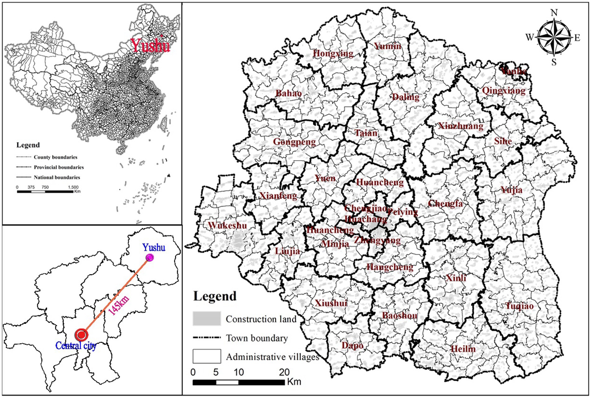
The focus area of this study is Yushu County (126°1′44″ E-127°5′9″ E-44°30′57″ N-45°15′2″ N) in northeastern Changchun city, a key grain-producing county in the Northeast black-soil region. Yushu County, known as “China’s First Grain Silo,” consists of 4 sub-districts, 25 towns and 363 administrative villages, covering an area of 4,722 km2 (Figure 1). In 2010, the Ministry of Agriculture designated Yushu County as one of the country’s 50 modern agricultural demonstration zones. Yushu County deviates from the central city of Changchun, resulting in an urban–rural settlement system shaped largely by endogenous socio-economic activities. In recent years, under the influence of agricultural mechanization and modernization, a large-scale exodus of rural population occurs in Yushu County, which triggers the emergency of rural hollowing and drastic transition in the settlement system. Dysfunctions in the countryside’s human-land relations, such as idle homesteads and wasted black-soil land, have become increasingly evident.
The data used in this article originate from three main source: First, the statistical data on population was collected from Sixth and seventh Census. Second, the points of interest (POI), including agricultural machinery services, medical facilities, and commercial establishments, were obtained from Tencent map platforms in June 2020. Third, the construction land and transportation routes were collected from very-fine-resolution color aerial photographs taken in June 2020. Referring to Yushu’s Comprehensive Plan, we make use of ArcGIS 10.7 to derive the national highways, provincial highways, county highways, township roads and rural construction land.
3.2 Methods
3.2.1 Rank-Size Rule
The Rank-Size Rule is primarily employed to examine the association between the size of settlements and their ordinal order within the entire system, reflecting the rationality of the settlement system in specific region. In essence, with the rapid advancement of urbanization and the implementation of the rural revitalization strategy, urban–rural integrated development has become the dominant trend shaping the future of urban–rural relations. Over time, the village system is expected to gradually integrate with the city-town system, forming a hierarchical settlement system characterized by interaction development among county-level cities, towns, central settlements, and natural settlements. Therefore, this article attempts to utilize the Rank-Size Rule to investigate the development level and evolution trend of urban–rural settlement system in the black-soil region.
The formula for the Rank-Size Rule improved by Zipf is as follows:
Where r represents the rank of the population size of settlements in descending order; Pr denotes the population size of the r-th settlement; P1 represents the population size of the first settlement in the system; q is the Zipf index estimated by a linear kernel model. For simplicity in calculation, a natural logarithmic transformation is typically applied to the equation:
3.2.2 Rural development potential index
According to the above theoretical framework and the availability of data, this article incorporates transportation accessibility, the density of agricultural and mechanical establishments, the density of medical facilities, and the density of commercial activities into Rural Development Potential. The weights of four indicators are 0.32, 0.30, 0.28 and 0.10, respectively, obtained from Analytic Hierarchy Process (AHP).
3.2.2.1 Traffic accessibility
Traffic accessibility is an effective indicator identifying village connectivity to external markets and internal space of village. The accessibility of villages to external markets facilitates their socio-economic development by enabling access to external support, such as market information and agricultural production exchange. The accessibility of internal village spaces reflects the ease with which villagers engage in agricultural production, influencing operational costs and farmers’ willingness to pursue agricultural activities. In ArcGIS software, travel speeds were assigned as follows: 70 km/h for national highways, 60 km/h for provincial highways, 40 km/h for county highways, and 30 km/h for township roads. Then, the OD cost matrix and travel time for each point in the county reaching all other points were calculated through the tool of Network Analysis. Finally, Kriging was applied to obtain a raster layer of county transportation accessibility, with travel time as the attribute.
3.2.2.2 Kernel density estimation
Kernel density estimation (KDE) is employed to analyze the spatial agglomeration of various service facilities (e.g., agricultural machinery services, medical facilities, and commercial establishments) across the county, and it lays the foundation for examining spatial heterogeneity of rural development potential in Yushu County. The density of agricultural machinery service establishments reflects the service capacity of settlements in the main grain-producing areas to support agricultural production; the density of medical facilities embodies the abilities of settlements to satisfy the basic health demands of residents, particularly under the background of an aging rural population; the density of commercial activities represents the capacity of the settlements to meet the daily necessities of inhabitants. KDE is expressed as follows:
3.2.3 Weighted Voronoi polygons
Voronoi polygons are a spatial analysis tool for seamless segmentation of planar space in light of a known set of points. The underlying principle is as follows: if the set of known points S = (p1, p2, p3,…pn) in space, and the Euclidean distance between any two points is d(p, pi), then the Voronoi polygon corresponding to each point V(pi) consists of all points in the planar space that are closest to the respective known point. This can be expressed as follows:
If each point in the plane is assigned a non-negative real weight, Voronoi polygons can seamlessly divide the space according to the weight, generating a weighted Voronoi polygons. Weighted Voronoi polygons are calculated as follows:
4 The evolution of urban–rural settlements in the black-soil region
4.1 Spatio-temporal changes in urban–rural population
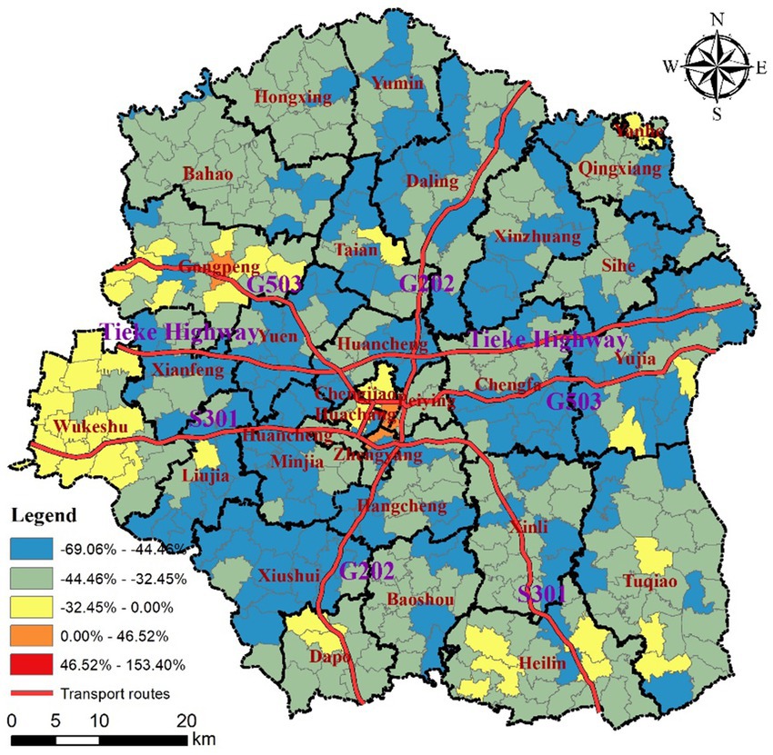
In 2010–2020, the urban population of Yushu County grew from 195,200 to 287,000, with an increase of 91,800, or an average annual growth rate of 3.83%. In contrast, the rural population declined from 950,200 to 549,100, with a decrease of 401,100, or an average annual decline of 5.34%. Over the past decade, the magnitude and rate of rural population loss in Yushu County have significantly exceeded those of urban population growth. This reflects the insufficient carrying capacity of county seat and towns to accommodate surplus rural laborers resulting from inadequate non-agricultural industries and public services. Consequently, the county’s rural population is compelled to seek employment elsewhere or even relocate entirely. It is worth noting that not all towns in the county have experienced growth, exhibiting a spatial pattern of “global shrinkage and sporadic growth.” As shown in Figure 2, during 2010–2020, the county seat of Yushu, Wukeshu Township and Gongpeng Township underwent the demographic growth, whereas the other townships suffered from population outflows. Specifically, the urban population in county seat increased from 142,600 to 239,300, with an increase of 68.08%. The non-agricultural population in Wukeshu Township rose from14,800, to 17,600, with an increase of 18.83%, while in Gongpeng Township, it increased from 7,800, to 8,500, with an increase of 8.20%. Theoretically, townships are hubs supplying public services in rural areas, and play an intermediary role in transmitting market information and agricultural technology between the county seat and surrounding countryside. The shrinkage of township in Yushu County has seriously undermined the countryside’s capacity to sustain existing population.
Large-scale population loss has occurred in rural areas of Yushu County, with depopulation rates varying across administrative villages. From 2010 to 2020, almost all administrative villages in Yushu County experienced population loss, with an average loss rate of 41.97%. As shown in Figure 2, the depopulated villages were mainly concentrated along S301, G202 and Tieke Highway, forming a belt-shaped zone of heavily depopulated villages in the southeast-northwest direction. In this zone, the village depopulation rates ranged from 44.46 to 69.06%.This zone is adjacent to the county’s growth poles, namely the county seat of Yushu and Wukeshu Township. Influenced by polarization, the rural population continually migrated towards the county seat of Yushu and Wukeshu Township. Villages with slight depopulation were scattered across Gongpeng Town, Tai’an Town, Liujia Town, Dapo Town, Hailin Town, Tuqiao Town, Yujia Town, and Yanhe Town. Wukeshu Township depends on product processing industries such as grain and oil, livestock and poultry, has sparked the process of rural industrialization which accommodated the local population of agricultural transfers. The urbanization exhibits the phenomenon of “leaving the land but not leaving the hometown,” which to some extent, mitigates the outflow of the rural population. The other villages are distant from the county seat, which restricts the diffusion of technological services from the center towards the countryside. Consequently, the agricultural production in these towns still heavily relies on the large-scale labor force, which delayed the emigration of rural population.
4.2 Changes in the size—hierarchy structure of urban–rural settlements
The size-hierarchy structure of urban–rural settlements in Yushu County demonstrates a tendency towards disorganization in Yushu County. As shown in Figure 3, in 2010, the size-hierarchy of urban–rural settlements exhibited a pyramid-like structure. The ratio of settlements with population sizes of over 6,000, 5,000-6,000, 4,000-5,000, 3,000-4,000, 2,000–3,000 and less than 2,000 was 1.54:1.29:3.08:7.22:45.76:31.11. As of 2020, the number of settlements with population of over 6,000, 5,000-6,000, 4,000-5,000, 3,000-4,000, 2,000–3,000 had decreased by 2, 4, 12, 66, 137, respectively. In contrast, the number of settlements with population of less than 2,000 increased by 221. Consequently, the composition of settlements deteriorated to 1.03:0.26:0.00:0.26:10.54:87.92. Evidently, the urban–rural settlement system in Yushu County formed a distorted structure featuring an excess of small settlements and a lack of large and medium-sized settlements. Large and medium-sized settlements are often critical nodes linking the county seat with the countryside, and play an intermediary role in the disseminating advanced production technologies and market information from the county seat. The underdevelopment of large and medium-sized settlements undermines the demonstration effect of the county seat on the socio-economic development of rural areas, which constrains synergistic development among the county seat, towns and settlements and hampers rural revitalization and retention of villagers in the countryside.
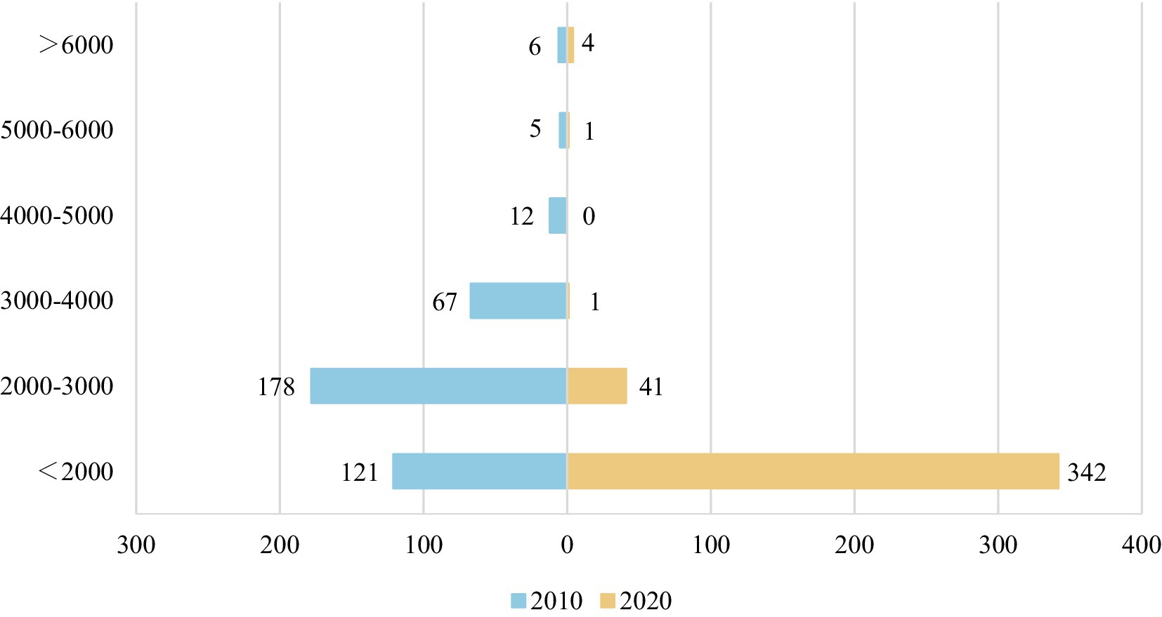
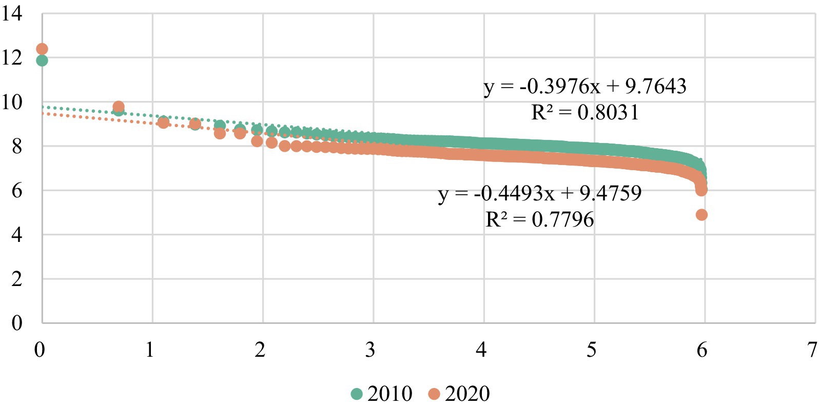
Figure 3. Evolution of size-hierarchy structure of urban–rural settlements in Yushu during 2010–2020.
The urban–rural settlement system of Yushu County approximately conforms to the Rank-Size Rule, however, signs of disorganization has begun to emerge. This is evidenced by the following observations. Firstly, in 2010–2020, the goodness of fit (R2) of rank-size curve for settlement system declined from 0.8031 to 0.7796. This suggests that the settlement system is increasingly diverging from the Rank-Size Rule. Secondly, the Zipf index (q) of the settlement system rose from 0.3976 to 0.4493 during 2010–2020, remaining below 1, which indicates the insufficient development of large settlements within the settlement system. Thirdly, from 2010 to 2020, the rank-size curve of settlement system displayed the morphology of “raising head, craning neck and drooping tail.” The population sizes of the first and second settlements, namely, county seat and Wukeshu Township, exceeded their theoretical values, and county seat’s population growth outperformed that of Wukeshu Township. During the study period, the population of county seat increased from 142,300 to 239,200, with an increase of 96,900, or 5.32% per annum. In comparison, the population of Wukesu Township increased from 14,800 to 17,600, with an increase of 2,800, or 1.75% per annum. Consequently, the “raising head” phenomenon in the rank-size curve is likely to exacerbate in the future. Additionally, medium-sized settlements remain underdeveloped, with less population than their theoretical value. The rank–size curve of the small settlements exhibited an obvious phenomena of “drooping tail,” deviating from the Rank-size Rule. This is because the polarization capacity of medium-sized settlements has decreased, impeding the population migration from small settlements to medium-sized ones (see Figure 4).
4.3 Spatial evolution of urban–rural settlements
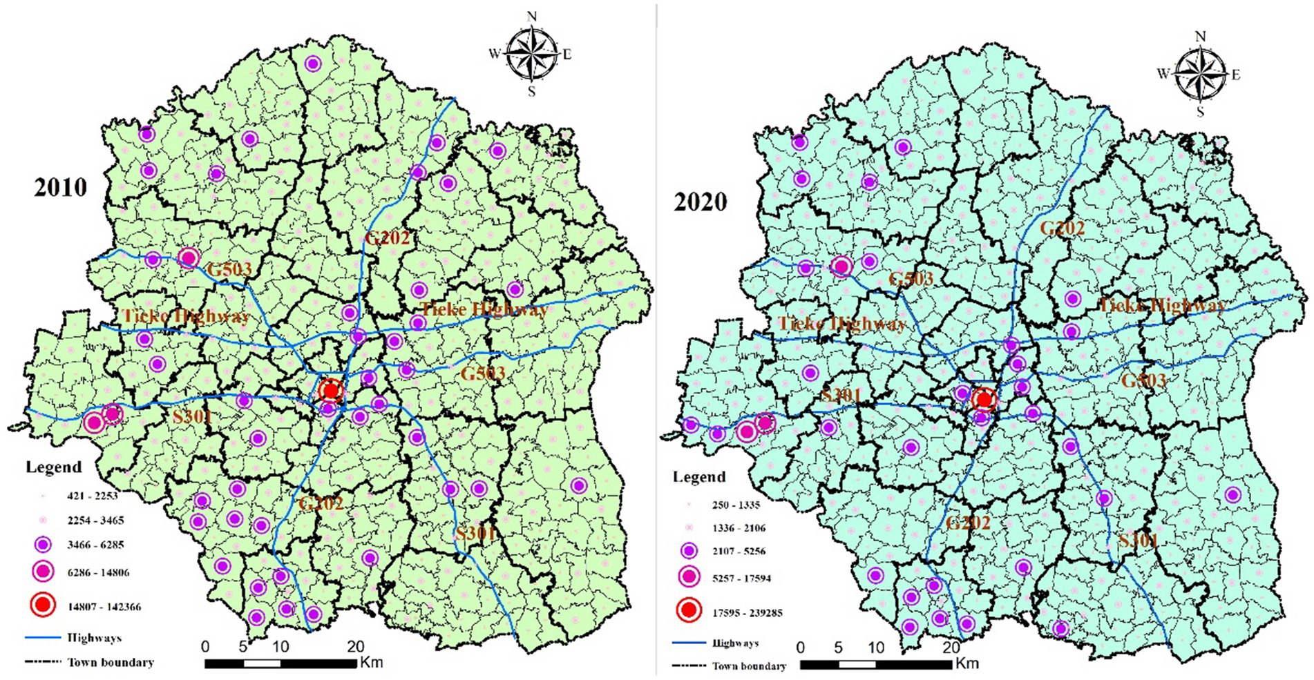
Spatial disequilibrium in the distribution of different rank-size settlements in Yushu County has further intensified. As shown in Figure 5, in 2010, Yushu County formed a spatial structure with “a center, triple poles and multiple axis.” “A center” refers to the county seat, located at the geometric center of the county which serves as hub for commercial services, agricultural product processing industries, and public services. The “triple poles” denote Wukeshu Township, Gongpeng Township, and Hefa Township which are situated in the western county. The “multiple axis” refer to a star-shaped axis network of medium-sized settlements along S301, G202, G503 and Tieke Highway, including Xiushui Township, Daling Township, and central settlements in Xinzhuang Town along G202, central settlements in Xinli Town along S301, central settlements in Xianfeng Town, Chengfa Township, and central settlements in Sihe Town along Daguang Highway. Overall, in 2010, large and medium-sized settlements were mainly concentrated in the western and southern parts of Yushu County. As of 2020, the spatial structure of “a center and three poles” remained in Yushu County, but the star-shaped network of axises had gradually disintegrated. The medium-sized settlements within the jurisdictions of Daling Town, Xiushui Town, Xinli Town and Sihe Town were downgraded to small-sized settlements. Currently, medium-sized settlements in Yushu County are mainly clustered on the southwest side of the line connecting Bahao Town and Heilin Town. The center of gravity for the spatial distribution of large and medium-sized settlements has started to shift towards the southwestern part of the county.
In the black-soil region of Northeast China, an administrative village usually consists of a central settlement and several natural settlements. To comprehensively reveal the spatial evolution of urban–rural settlements in the county, it is essential to analyze the spatial structure of the urban–rural settlement system from the perspective of urban–rural construction land. In Yushu County, the distribution of settlements is relatively fragmented, exhibiting a spatial mismatch with the spatial patterns of various rank-size settlements. As shown in Figure 6, in 2020, the settlements exhibited a spatial pattern characterized by a combination of a center and multiple cores. A center refers the high-density construction land area formed by the aggregation of the built-up area of Yushu and the settlements at the city’s periphery. “Multiple cores” refer to high density construction land areas formed by the aggregations of settlements within the jurisdictions of Wukeshu Town, Gongpeng Town, Bahao Town, Daling Town, Sihe Town, Yujia Town, Tuqiao Town, Xinli Town, Heilin Town, Baoshou Town, Xiushui Town, Minjia Town, and Liujia Town. From the perspective of administrative villages, Yushu County has developed a relatively complete urban–rural settlement system, encompassing large-, medium- and small-size settlements. However, considering the fragmented distribution of natural settlements, the population allocated to the settlements could be decreased, further undermining the integrity of the urban–rural settlement system. Noteworthy, in the northeast part of Yushu County, several high-density construction land areas emerged in Daling Town, Sihe Town, Yujia Town, Tuqiao Town, Hailin Town. But few medium-sized administrative villages existed in the area. The fragmented settlement pattern undermines effects of demographic agglomeration on the socio-economic development of the rural areas, which is not conductive to growth and upgrading of settlements.
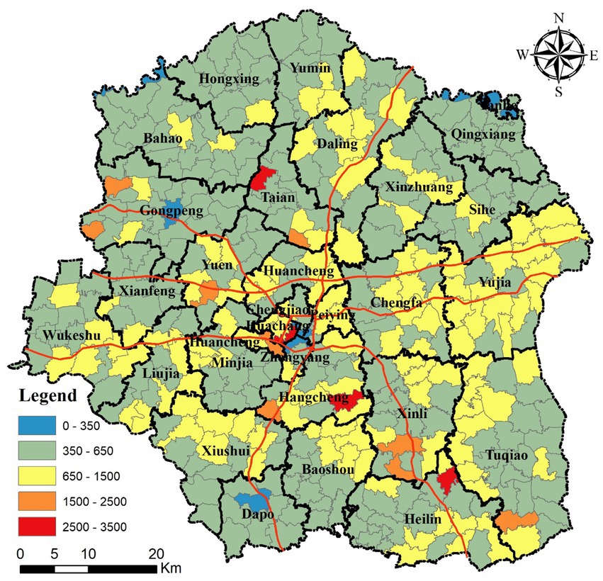
Homestead abandonment is another notable feature of the spatial evolution of settlements in Yushu County. From 2010 to 2020, construction land per capita increased from 380.74 m2/person to 658.97 m2/person, 4.39 times the standard upper limit of 150 m2 per capita for urban and rural construction land. More specifically, the proportion of administrative villages with construction land per capita of 0–350, 350–650, 650–1,500, 1,500–2,500 and 2,500–3,500 m2/person was 2.55, 62.24, 31.88, 2.30 and 0.76%, respectively. More than 90% of the administrative villages had per capita construction land ranging from 350 m2/person to 1,500 m2/person. As shown in Figure 7, administrative villages with construction land per capita exceeding 1,500 m2/person were sporadically distributed across Gongpeng Town, Tai’an Town, Tuqiao Town, Xinli Town, and Huancheng Town. Administrative villages with construction land per capita ranging from 650 m2/person to 1,500 m2/person were mainly concentrated in the towns of Yujia, Hailin, Daling, Xiushui, Tuqiao, Xinli, Liujia, Minjia, Huancheng and Enyu. There are three settlements with construction land per capita of less than 350 m2/person, namely, Township of Gongeng, Township of Dapo, and county seat of Yushu. Yushu County is a high-quality black-soil catchment area, and unused or abandoned homesteads in rural areas are a significant waste of black-soil land. Additionally, scattered and disintegrated inhabited settlements hinder the implementation of large-scale agricultural operations and the promotion of advanced production technologies. Therefore, reconfiguring urban–rural settlement system is an efficient strategy for achieving the protective utilization of black-soil land.
5 Strategies for reconstructing urban–rural settlement system
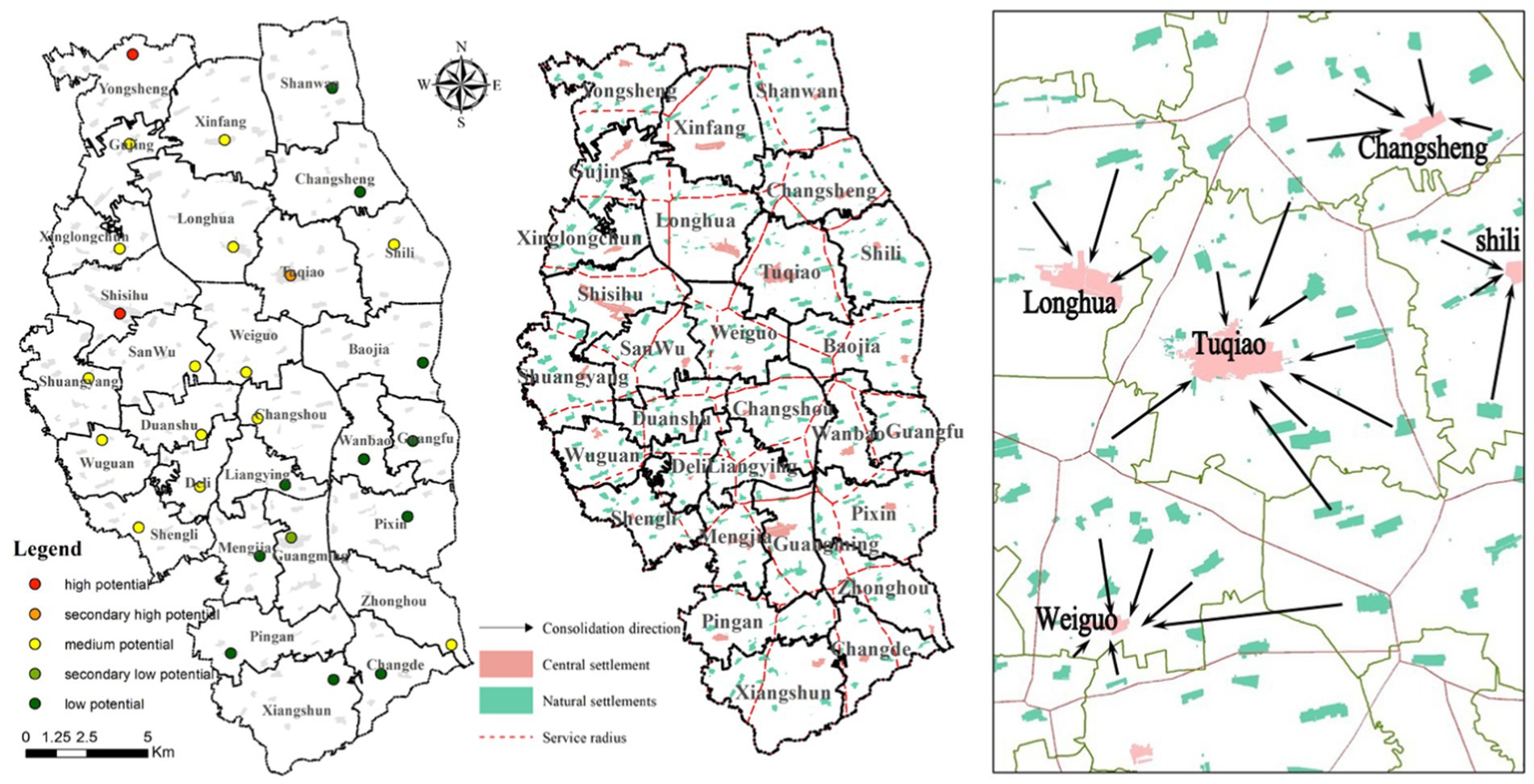
Considering the rank-size characteristics of the settlement system, we argue that the reconfiguration of the settlement system in the black soil region should prioritize increasing the number of large and medium-size settlements by consolidating the population and construction land of low-ranked settlements into relatively high-ranked settlements. More specifically, this process involves two scale: administrative village scale and town scale. In administrative villages with strong potential for socio-economic development, the merger of settlements should be implemented in the administrative village, without disassembling the administrative boundaries. The scattered natural settlements should be integrated into central settlements. With respect to administrative villages with weak socio-economic development potential, settlements should be integrated across administrative villages within the town. Initially, administrative divisions within the town should be reconstructed based on the ideal service radius of central settlements (see Figure 8). Correspondingly, natural settlements should be integrated into the central settlements within the boundaries of the newly defined administrative divisions.
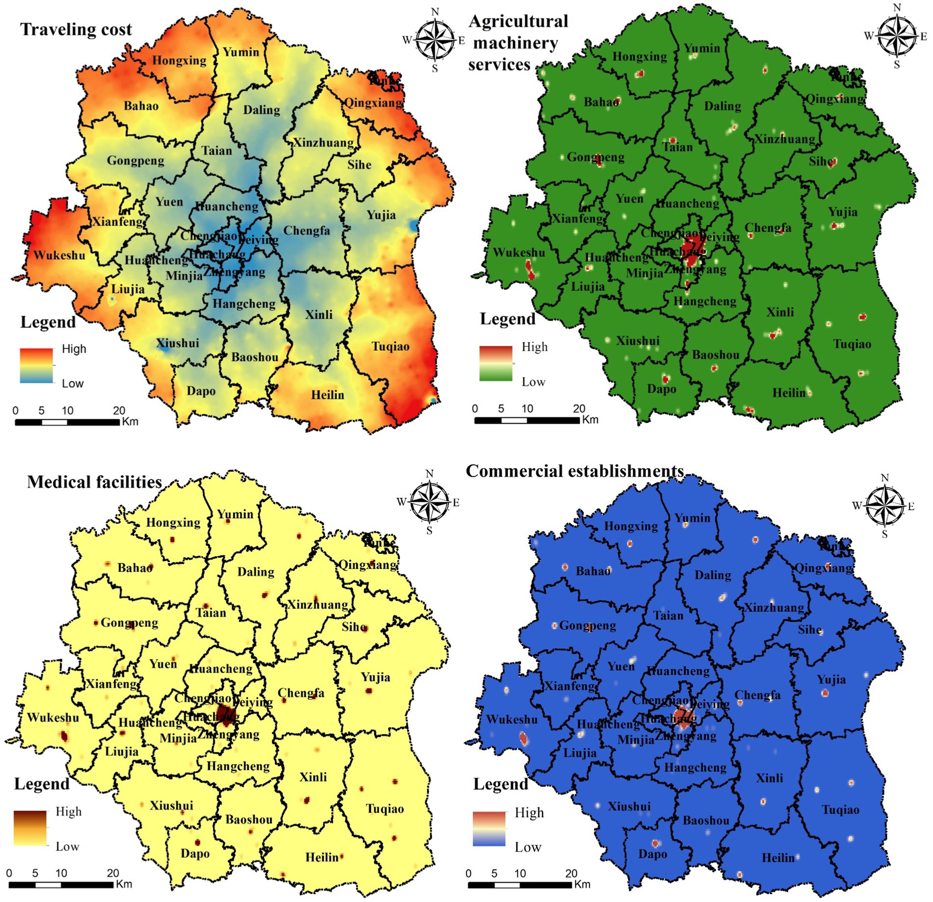
Figure 8. Spatial distribution of indicators for evaluating rural development potential in Yushu County.
5.1 Identification of rural development potential
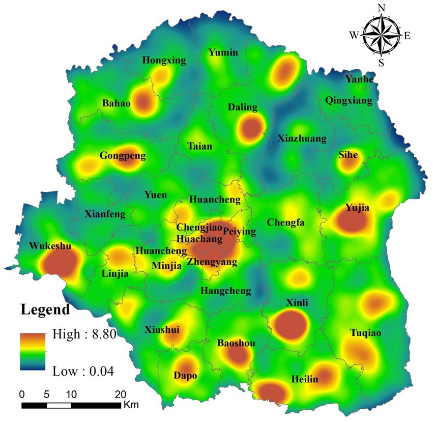
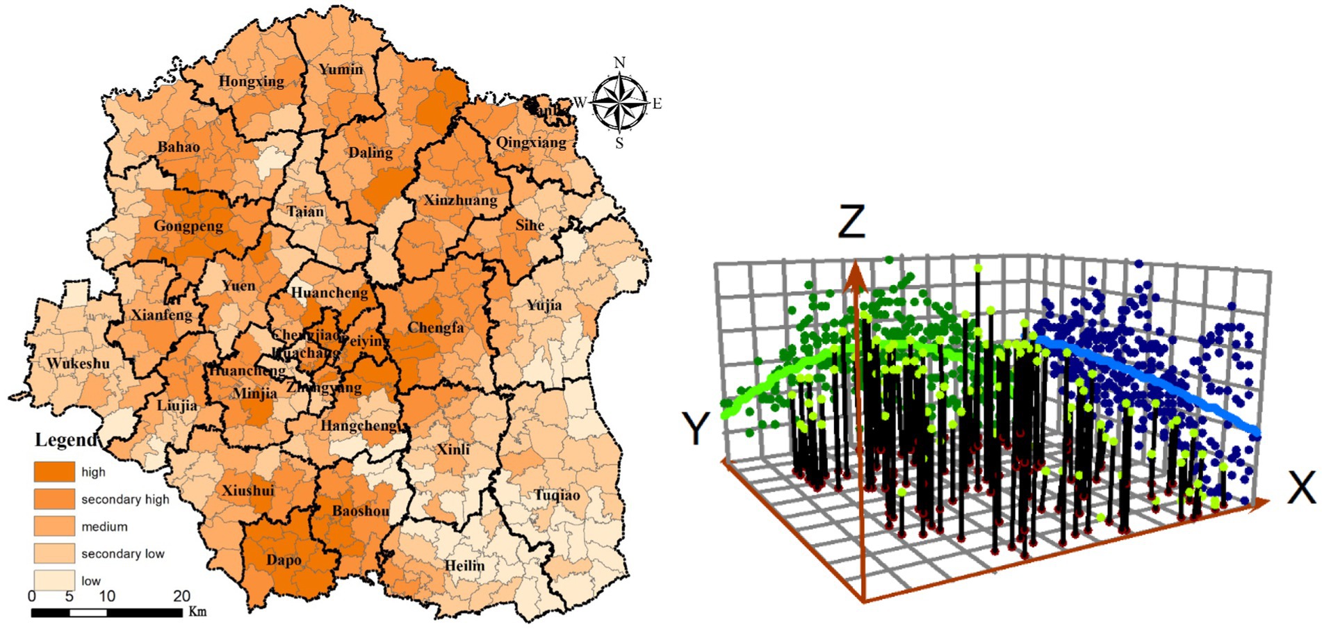
Overall, rural development potential in Yushu County was relatively weak, and most administrative villages demonstrated medium or low-level rural development potential. In 2020, administrative villages with high-level, secondary high-level, medium-level, secondary low-level, and low-level potential took up 11.20, 24.22, 26.56, 26.04 and 11.98%, respectively. A total of 64.58% of administrative villages displayed moderate or lower rural development potential. Spatially (Figure 9), the rural development potential gradually decreased from north to south. From west to east, the rural development potential initially increased and then decreased. As shown in Figure 9, in 2020, Yushu County formed five high-potential areas: Daling-Xinzhuang area, Gongpeng-Bahao area, the County seat of Yushu—Chengfa area, Minjia-Liujia areay, and the Dapo-Baoshou area. Meanwhile, three low-potential areas were identified, namely Heilin-Tuqiao area, Yujia area and Sihe area.
5.2 Strategies for reconfiguring high-potential administrative villages
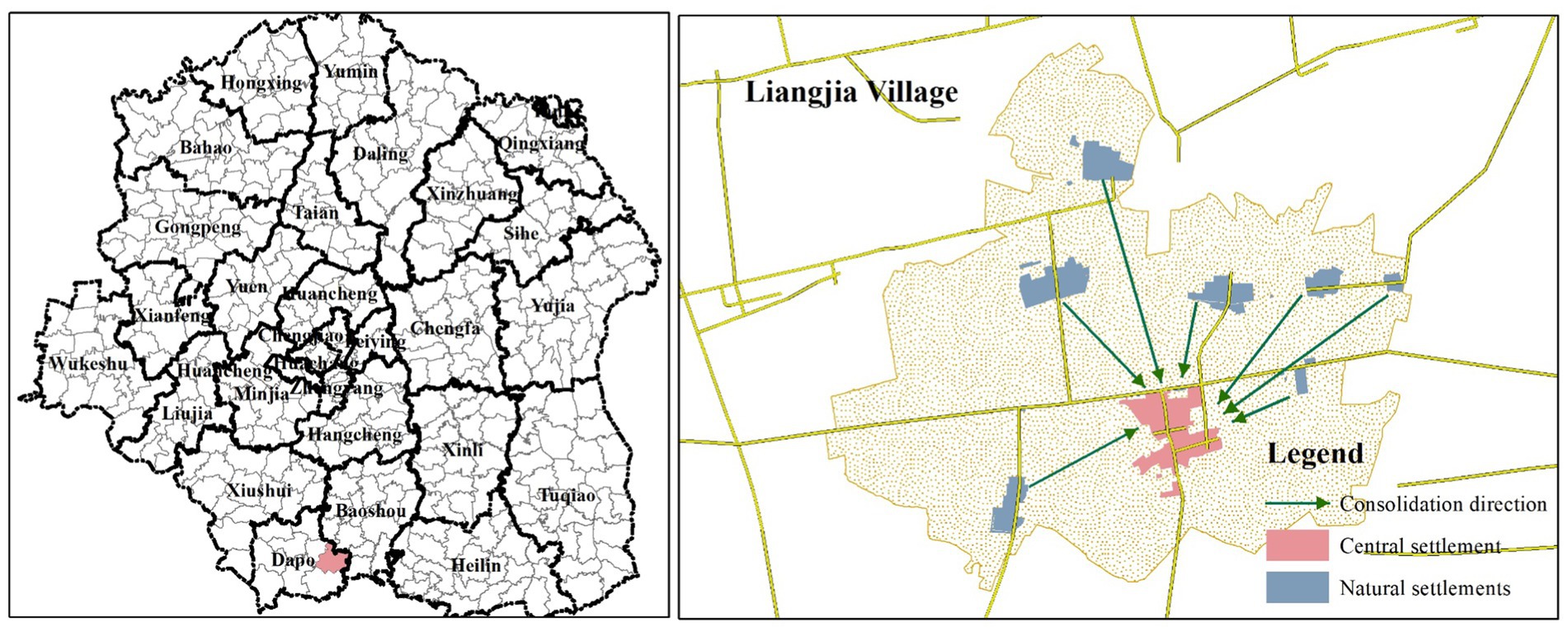
According to results of rural development potential analysis, we selected Liangjia villages in Dapo Town to visualize the reconfiguration model of high-potential administrative villages. As shown in Figure 10, the central settlement is located at the geometric center of the administrative village. It is both the center of the transportation network and the hubs of grass-roots management, as well as the settlement with the largest amount of construction land and the most population within the administrative village. The integration of natural settlements into the central settlement offers four key advantages. Firstly, settlement consolidation is conducted entirely within the administrative village, preserving administrative efficiency, local customs and culture, agricultural cultivation radius, and villagers’ living habits. Secondly, the central settlement, occupying large built-up area, serves as the seat of the grass-roots management organizations and it is relatively well equipped with public service facilities. In the process of settlement consolidation, idle homesteads in the central settlement can be reutilized in the form of replacement subsidies to resettle the residents from the natural settlements. Furthermore, existing public service facilities could be effectively utilized to satisfy residents’ basic demands, thereby reducing construction costs. Thirdly, it is a strategy to implement easily resulting from preserving the original land tenure and acquaintance network. Additionally, it enhances the rural neighborhood relations through the centralized rehabilitation of existing residents. Fourthly, it lays the foundation for consolidating scattered plots of land previously fragmented by dispersed settlements, facilitating land transfer, large-scale operations, and mechanized farming.
5.3 Strategies for reconfiguring low-potential administrative villages
In the light of rural development potential, Tuqiao Town was selected as a case study to illustrate the spatial restructuring pattern of low-potential administrative villages. The administrative villages within Tuqiao Town lacked endogenous development incentives, resulting in insufficient development of central settlements and a disorganized settlement system. Therefore, in Tuqiao Town, cultivating central settlements to increase their size and rank through settlement consolidation is critical. The implementation process involves the following steps. Firstly, the Weighted Voronoi method was employed to determine the ideal service radius of each central settlement according to respective rural development potential. As shown in Figure 11, the service radius of central settlements does not exactly align with the boundaries of the administrative village. For example, central settlements with high rural development potential, such as Tuqiao, Xietou and Longhua, have a spatial radius extending beyond their respective village boundaries, and vice versa. The spatial radius of a central settlement is influenced by the combined effects of its traffic accessibility, ability to provide agricultural and mechanical services, the levels of health care and commercial development, representing the actual served area of each central settlement. Secondly, the spatial radius of each central settlement is taken as the basic unit used for settlement consolidation, instead of administrative division of the village, and the natural settlements within the spatial radius are integrated into the corresponding central settlement. In this process, a central settlement with a large spatial radius may integrate natural settlements beyond its administrative boundary. For instance, the central settlement of Tuqiao would merge several natural settlements from the neighboring villages of Baojia, Weiguo and Changsheng. Finally, settlements with high rural development potential were allocated with more population and construction land, while settlements with low rural development potential experienced reductions in population and construction land to align with their service capacity. This strategy offers two main advantages. On the one hand, it does not alter the number of administrative villages and retains the original grass-roots administrative structure. Existing administrative bodies are familiar with of villages affairs, facilitating the coordination of stakeholders involved in settlement consolidation. On the other hand, although some natural settlements are not subordinate to the targeted administrative villages, they form more intimate association with central settlements in the targeted administrative villages for living and production activities compared to the central settlement in the affiliated administrative villages. In practice, these settlements have already established functional ties to central settlements in the targeted villages, which fosters emotional acceptance among indigenous residents during settlement consolidation. Hence, it facilitates the effective operation and implementation of settlement consolidation.
6 Discussion and conclusions
6.1 Discussion
The black soil regions are global agglomerations of high-quality arable land and critical commodity grain bases, and their sustainable utilization holds outstanding strategic importance for global grain security. Rural settlements serve as crucial nodes for human-land interactions in the black soil regions, and they provides habitation for farmers and enables farmers to engage in agriculture. Thus, the spatiotemporal trajectories of settlements present a panorama of the human-land relations in the black soil regions. Currently, in process of rapid migration from rural areas to urban, the black-soil region of China has faced serious human-land contradictions, including homestead abandonment, cropland underutilization, and environmental deterioration, which puts spatial optimization of rural settlements at the forefront of rural revitalization. Rural settlement restructuring has received attention from rural geographers, who have proposed innovative modes of spatial optimization of settlements (Lu et al., 2020; Li et al., 2014; Zou et al., 2021). Nonetheless, extant patterns have mainly focused on consolidation or reservation from the perspective of individual settlements, with limited attention to the integrity of the regional settlement system. Settlements are not isolated territorial containers, instead, they maintain interrelationships with towns and cities, requiring feedback that do not confine to the administrative villages. Singular adjustments to individual settlements cannot fully achieve the optimization of human-land relations at the regional scale.
Existing studies on rural restructuring in the black soil region has proposed a reconstruction pattern that consolidates scattered, small natural settlements into the central settlement within an administrative village (Li et al., 2021). However, this pattern overlooks the capacity of public services in the central settlement to accommodate the merged population. If public services in the central settlement fail to support the relocated villagers, they would face the risk of “secondary” relocation. Theoretically, in a given geographical unit, the number of settlements decreases as their population size increases (Christaller, 1966). Blindly consolidating natural settlements into the central settlements may lead to redundant development of large settlements, incurring vicious competition among them. Additionally, other modes mainly focus on rural areas with well-developed market mechanisms, emphasizing the importance of symbiotic relations among settlements in rural restructuring (Gao and Cheng, 2020; Rao et al., 2023; Ma et al., 2024). The direction of settlement consolidation is determined by the frequency of socio-economic connections among settlements (Kong et al., 2021; Ma et al., 2022; Tian et al., 2016). However, this approach does not apply to rural restructuring in the black soil region, which is characterized by a heavily planned economy. Rural settlements in the black soil region do not form intimate economic connections with each other, and villagers tend to seek living and production services in towns and cities. Traffic accessibility still exert a decisive influence on the spatial optimization of rural settlements (Yin et al., 2023). In view of this, rural restructuring in black soil region should consider both administrative village and town scales to determine the direction of settlement consolidation. Areas with high rural development potential could implement a strategy of merging natural settlements into central settlement within an administrative village. In the areas with low potential for rural development, the direction of settlement consolidation is determined according to the ideal transportation and health care service radius of central settlements in the town.
6.2 Conclusion
In the black soil region, population changes presented spatial heterogeneity characterized by “urban growth and rural shrinkage,” with the rate of rural shrinkage significantly exceeding that of urban growth. Consequently, the hierarchy-size structure of urban–rural settlements have gradually fallen into a state of disorder. During 2010–2020, the urban–rural settlement system deteriorated from a relatively balanced “pyramid” structure to a distorted one with an excess of small settlements and a deficiency of large and medium-sized settlements. Accordingly, the system started to deviate from the “rank-size” rule, and its rank-size curve demonstrated irrational morphology characterized by raising head, craning neck and drooping tail. The Ziff index of the urban–rural settlement system is less than 1, indicating a weak radiating effect of the county center on the development of settlements in its administrative boundaries.
More specifically, the population size of the first-ranked settlement surpassed its theoretical value simulated by the rank-size rule, whereas the middle-ranked settlements had population sizes below their theoretical values. The population size of low-ranked settlements deviated entirely from the rank-size rule. Noteworthy, in the black soil region, rural settlements are spatially fragmented, and a village consists of a central settlement and several natural settlements. Given the fragmented pattern of rural settlements, the goodness of fit for rank-size curve would be further decrease. Regarding to spatial distribution, the county exposed mismatch between rural residential land and population across various settlement sizes, incurring severe idling and abandonment of rural construction land. Correspondingly, the rural development potential displayed two aggregation patterns, namely high-high pattern and low-low pattern. In the light of the spatial pattern, it is appropriate to optimize the urban–rural settlement system at the scale of administrative villages and towns. In areas with high development potential, the settlement system should be reorganized by consolidation of natural settlements into central settlement within administrative villages. In areas with low development potential, the mergences of natural settlements are suitable for achievement within the town, and their relocation direction could be determined according to functional radius of each central settlement, thereby reshaping the jurisdictional boundaries of administrative villages.
Considering the natural and socio-economic context of the study area, the applicability of the proposed rural settlement restructuring mode is determined by three conditions. First, the rural area is located in a densely populated plains with dispersed settlements. Second, the area lacks a fully developed market economy, with rural settlements exhibiting significant self-sufficiency in both production and consumption. Traffic accessibility and the provision of public services play a decisive role in the distribution of rural settlements. Third, the rural area is geographically distant from regional central cities, with settlement evolution being less influenced by these central cities, thereby showing strong spontaneity and independence.
This paper examines the spatiotemporal characteristics, development trends, and reconstruction patterns of urban–rural settlement system in Yushu, a representative county in the black soil region. However, limited by the availability of data, this study merely employs density of POIs to represent the rural development potential. Weighted Voronoi polygons based on static rural development potential provide an approximate representation of the ideal service radius of central settlements. In the further, we will collect data on the “flow” between central and natural settlements through field research to refine the rural settlement restructuring mode. Moreover, in suburban areas, the central city exerts a profound radiating influence on rural settlements, differing from the study case settlements. Restructuring modes for rural areas adjacent to central cities deserve further exploration.
Data availability statement
The raw data supporting the conclusions of this article will be made available by the authors, without undue reservation.
Author contributions
ZM: Writing – original draft, Conceptualization, Data curation, Formal analysis, Funding acquisition, Investigation, Methodology, Project administration, Resources, Software, Supervision, Validation, Visualization, Writing – review & editing. YT: Methodology, Writing – original draft, Writing – review & editing. JL: Data curation, Writing – original draft, Writing – review & editing. GZ: Conceptualization, Software, Writing – original draft, Writing – review & editing. YL: Conceptualization, Supervision, Writing – review & editing, Project administration, Writing – original draft. XW: Formal analysis, Methodology, Writing – original draft, Writing – review & editing. PZ: Conceptualization, Supervision, Writing – review & editing, Writing – original draft.
Funding
The author(s) declare that financial support was received for the research, authorship, and/or publication of this article. This research study was supported by the Strategic Pilot Science and Technology Project of the Chinese Academy of Sciences (XDA28020403), National Natural Science Foundation of China (grant numbers 42401249, 42071162, 42171297, 42201211), Young Scientist Group Project of Northeast Institute of Geography and Agroecology, Chinese Academy of Sciences (2022QNXZ02), China Postdoctoral Science Foundation (2023M733483).
Conflict of interest
The authors declare that the research was conducted in the absence of any commercial or financial relationships that could be construed as a potential conflict of interest.
Generative AI statement
The authors declare that no Gen AI was used in the creation of this manuscript.
Publisher’s note
All claims expressed in this article are solely those of the authors and do not necessarily represent those of their affiliated organizations, or those of the publisher, the editors and the reviewers. Any product that may be evaluated in this article, or claim that may be made by its manufacturer, is not guaranteed or endorsed by the publisher.
References
Andrzej, S. (1992). Problem of depopulation of rural areas in Poland after 1950. Landsc. Urban Plan. 22, 161–175.
Chen, Z., Liu, Y., Feng, W., Li, Y., and Li, L. (2022). Study on spatial tropism distribution of rural settlements in the loess hilly and gully region based on natural factors and traffic accessibility. J. Rural. Stud. 93, 441–448. doi: 10.1016/j.jrurstud.2019.02.014
Dong, Y., Cheng, P., and Kong, X. (2022). Spatially explicit restructuring of rural settlements: a dual-scale coupling approach. J. Rural. Stud. 94, 239–249. doi: 10.1016/j.jrurstud.2022.06.011
Dwyer, J., and Powell, J. (2016). Rural development programmes and transaction effects: reflections on Maltese and English experience. J. Agric. Econ. 67, 545–565. doi: 10.1111/1477-9552.12166
Fei, X. (1947). From the soil: The foundations of Chinese society. Berkeley, CA: University of California Press.
Gao, C., and Cheng, L. (2020). Tourism-driven rural spatial restructuring in the metropolitan fringe: an empirical observation. Land Use Policy 95:104609. doi: 10.1016/j.landusepol.2020.104609
Garcia, A. I., and Ayuga, F. (2007). Reuse of abandoned buildings and the rural landscape: the situation in Spain. Trans. ASABE 50, 1383–1394. doi: 10.13031/2013.23627
Giesen, K., and Südekum, J. (2010). Zipf’s law for cities in the regions and the country. J. Econ. Geogr. 11, 667–686. doi: 10.1093/jeg/lbq019
Godfray, H. C., Beddington, J. R., Crute, I. R., Haddad, L., Lawrence, D., Muir, J. F., et al. (2010). Food security: the challenge of feeding 9 billion people. Science 327, 812–818. doi: 10.1126/science.1185383
Gong, J., Jian, Y., Chen, W., Liu, Y., and Hu, Y. (2022). Transitions in rural settlements and implications for rural revitalization in Guangdong Province. J. Rural. Stud. 93, 359–366. doi: 10.1016/j.jrurstud.2019.10.037
Hill, M. (2003). Rural settlement and the urban impact on the countryside. London: Hodder & Stoughton.
Hong, J., Park, S., and Yang, H. (2022). In strongman we trust: the political legacy of the New Village movement in South Korea. Am. J. Polit. Sci. 67, 545–565. doi: 10.1111/ajps.12716
Hu, Z., Li, Y., Long, H., and Kang, C. (2023). The evolution of China’s rural depopulation pattern and its influencing factors from 2000 to 2020. Appl. Geogr. 159:103089. doi: 10.1016/j.apgeog.2023.103089
Huang, Q., Song, W., and Song, C. (2020). Consolidating the layout of rural settlements using system dynamics and the multi-agent system. J. Clean Prod. 274:123150. doi: 10.1016/j.jclepro.2020.123150
Ji, Z., Xu, Y., Sun, M., Liu, C., Lu, L., Huang, A., et al. (2022). Spatiotemporal characteristics and dynamic mechanism of rural settlements based on typical transects: a case study of Zhangjiakou City, China. Habitat Int. 123:102545. doi: 10.1016/j.habitatint.2022.102545
Kong, X., Liu, D., Tian, Y., and Liu, Y. (2021). Multi-objective spatial reconstruction of rural settlements considering intervillage social connections. J. Rur. Sci. 84, 254–264.
Lapping, M. B., and Fuller, A. M. (1985). Rural development policy in Canada: an interpretation. Community Dev. J. 20, 114–119. doi: 10.1093/cdj/20.2.114
Li, L., Li, X., Hai, B., Wang, X., and Xu, J. (2020). Evolution of rural settlement in an inland nonmetropolitan region of China at a time of rapid urbanisation: the case of Gongyi. J. Rural. Stud. 79, 45–56. doi: 10.1016/j.jrurstud.2020.08.003
Li, Y., Liu, Y., Long, H., and Cui, W. (2014). Community-based rural residential land consolidation and allocation can help to revitalize hollowed villages in traditional agricultural areas of China: evidence from Dancheng County, Henan Province. Land Use Policy 39, 188–198. doi: 10.1016/j.landusepol.2014.02.016
Li, T., Long, H., Liu, Y. Q., and Tu, S. (2015). Multi-scale analysis of rural housing land transition under China’s rapid urbanization: the case of Bohai rim. Habitat Int. 48, 227–238. doi: 10.1016/j.habitatint.2015.04.002
Li, Y., Qiao, L., Wang, Q., and Dávid, K. (2020). Towards the evaluation of rural livability in China: theoretical framework and empirical case study. Habitat Int. 105:102241. doi: 10.1016/j.habitatint.2020.102241
Li, Y., Wu, W., and Liu, Y. (2018). Land consolidation for rural sustainability in China: practical reflections and policy implications. Land Use Policy 74, 137–141. doi: 10.1016/j.landusepol.2017.07.003
Li, X., Yang, H., Jia, J., Shen, Y., and Liu, J. (2021). Index system of sustainable rural development based on the concept of ecological livability. Environ. Impact Assess. Rev. 86:106478. doi: 10.1016/j.eiar.2020.106478
Li, H., Yuan, Y., Zhang, X., Li, Z., Wang, Y., and Hu, X. (2022). Evolution and transformation mechanism of the spatial structure of rural settlements from the perspective of long-term economic and social change: a case study of the Sunan region, China. J. Rural. Stud. 93, 234–243. doi: 10.1016/j.jrurstud.2019.03.005
Li, H., Zhang, X., Wu, Q., and Wang, Y. (2015). Characteristics and mechanism of rural settlements spatial reconstruction in developed areas — a case study of southern Jiangsu. J. Nat. Resour. 30, 591–603.
Lin, J., Lei, J., Wu, S., Yang, Z., and Li, J. (2020). Spatial pattern and influencing factors of oasis rural settlements in Xinjiang, China. Geogr. Res. 39, 1182–1199.
Liu, Y., Li, X., and Guo, Y. (2024). Exploring land system reform for demographic transition in rural China. Land Use Policy 147:107355. doi: 10.1016/j.landusepol.2024.107355
Liu, Y., Liu, Y., Chen, Y., and Long, H. (2010). The process and driving forces of rural hollowing in China under rapid urbanization. J. Geogr. Sci. 20, 876–888. doi: 10.1007/s11442-010-0817-2
Liu, Y., Lu, S., and Chen, Y. (2013). Spatio-temporal change of urban–rural equalized development patterns in China and its driving factors. J. Rural. Stud. 32, 320–330. doi: 10.1016/j.jrurstud.2013.08.004
Lobley, M., and Potter, C. (2004). Agricultural change and restructuring: recent evidence from a survey of agricultural households in England. J. Rural. Stud. 20, 499–510. doi: 10.1016/j.jrurstud.2004.07.001
Long, H. (2014). Land consolidation: an indispensable way of spatial restructuring in rural China. J. Geogr. Sci. 24, 211–225. doi: 10.1007/s11442-014-1083-5
Lu, M., Wei, L., Ge, D., Sun, D., Zhang, Z., and Lu, Y. (2020). Spatial optimization of rural settlements based on the perspective of appropriateness–domination: a case of Xinyi City. Habitat Int. 98:102148. doi: 10.1016/j.habitatint.2020.102148
Ma, L., Li, J., Wang, X., Zhang, W., Tao, T., and Zhong, Y. (2024). Evolution and simulation optimization of rural settlements in urban-rural integration areas from a multi-gradient perspective: a case study of the Lan-Bai urban agglomeration in China. Habitat Int. 153:103203. doi: 10.1016/j.habitatint.2024.103203
Ma, L., Liu, S., Tao, T., Gong, M., and Bai, J. (2022). Spatial reconstruction of rural settlements based on livability and population flow. Habitat Int. 126:102614. doi: 10.1016/j.habitatint.2022.102614
Ma, L., Tian, Y., Guo, X., Chen, M., and Wang, Y. (2018). Spatial-temporal change of rural settlements and its spatial coupling relationship with water and soil resources based on grid in the Hexi oasis. J. Nat. Resour. 33, 775–787.
Phillips, M. (2010). Counterurbanisation and rural gentrifcation: an exploration of the terms. Popul. Space Place 16, 539–558. doi: 10.1002/psp.570
Qu, Y., Zhan, L., Jiang, G., Ma, W., and Dong, X. (2021). How to address “population decline and land expansion (PDLE)” of rural residential areas in the process of urbanization: a comparative regional analysis of human-land interaction in Shandong Province. Habitat Int. 117:102441. doi: 10.1016/j.habitatint.2021.102441
Rao, Y., Zou, Y., Yi, C., Luo, F., Song, Y., and Wu, P. (2023). Optimization of rural settlements based on rural revitalization elements and rural residents’ social mobility: a case study of a township in western China. Habitat Int. 137:102851. doi: 10.1016/j.habitatint.2023.102851
Siciliano, G. (2012). Urbanization strategies, rural development and land use changes in China: a multiple-level integrated assessment. Land Use Policy 29, 165–178. doi: 10.1016/j.landusepol.2011.06.003
Sonis, M., and Grossman, D. (1984). Rank-size rule for rural settlements. Socio-Econ. Plan. Sci. 18, 373–380. doi: 10.1016/0038-0121(84)90046-6
Sun, J., Liu, Y., Ge, D., Lu, Y., and Niu, B. (2022). Coordinated mechanism between comprehensive land consolidation and rural transformation development in plain agricultural areas of China. Acta Geograph. Sin. 77, 1971–1986.
Sun, P., Song, W., Xiu, C., and Liang, Z. (2013). Non-coordination in China’s urbanization: assessment and affecting factors. Chin. Geogr. Sci. 23, 729–739. doi: 10.1007/s11769-013-0634-5
Tan, M., and Li, X. (2013). The changing settlements in rural areas under urban pressure in China: patterns, driving forces and policy implications. Landsc. Urban Plan. 120, 170–177. doi: 10.1016/j.landurbplan.2013.08.016
Tian, Y., Kong, X., Liu, Y., and Wang, H. (2016). Restructuring rural settlements based on an analysis of inter-village social connections: a case in Hubei Province, Central China. Habitat Int. 57, 121–131. doi: 10.1016/j.habitatint.2016.07.007
Tian, Y., Liu, Y., and Kong, X. (2018). Restructuring rural settlements based on mutualism at a patch scale: a case study of Huangpi District, Central China. Appl. Geogr. 92, 74–84. doi: 10.1016/j.apgeog.2018.01.015
Tian, G. J., Qiao, Z., and Gao, X. L. (2014). Rural settlement land dynamic modes and policy implications in Beijing metropolitan region, China. Habitat Int. 44, 237–246. doi: 10.1016/j.habitatint.2014.06.010
Tu, S., and Long, H. (2017). Rural restructuring in China: theory, approaches and research prospect. J. Geogr. Sci. 27, 1169–1184. doi: 10.1007/s11442-017-1429-x
Tu, L., Wang, Y., and Li, M. (2024). The emergence of counter-urbanisation in China: can it be a pathway for rural revitalisation? Habitat Int. 144:102998. doi: 10.1016/j.habitatint.2023.102998
Wang, X. (2010). The research on the evaluation index system of livable rural areas in China—by the case of rural areas in Henan Province. Agric. Agric. Sci. Procedia 1, 456–461. doi: 10.1016/j.aaspro.2010.09.057
Wang, Y., Chen, X., Sun, P., Liu, H., and He, J. (2021). Spatial-temporal evolution of the urban-rural coordination relationship in Northeast China in 1990–2018. Chin. Geogr. Sci. 31, 429–443. doi: 10.1007/s11769-021-1202-z
Wang, F., Li, S., Liu, L., Gao, F., Feng, Y., and Chen, Z. (2024). A novel index for assessing the rural population hollowing at fine spatial resolutions based on Tencent social media big data: a case study in Guangdong Province, China. Land Use Policy 137:107028. doi: 10.1016/j.landusepol.2023.107028
Yang, R., Xu, Q., and Long, H. (2016). Spatial distribution characteristics and optimized reconstruction analysis of China’s rural settlements during the process of rapid urbanization. J. Rural. Stud. 47, 413–424. doi: 10.1016/j.jrurstud.2016.05.013
Yao, G., and Xie, H. (2016). Rural spatial restructuring in ecologically fragile mountainous areas of southern China: a case study of Changgang town, Jiangxi Province. J. Rural. Stud. 47, 435–448. doi: 10.1016/j.jrurstud.2016.07.014
Ye, C., Ma, X., Gao, Y., and Johnson, L. (2020). The lost countryside: spatial production of rural culture in Tangwan village in shanghai. Habitat Int. 98:102137. doi: 10.1016/j.habitatint.2020.102137
Yin, J., Wang, D., and Li, H. (2023). Spatial optimization of rural settlements in ecologically fragile regions: insights from a social-ecological system. Habitat Int. 138:102854.
Yukihiko, S. (2007). Depopulation and rural special management: a case study in Shimoina County. J. Asian Archit. Build. Eng. 16, 259–266. doi: 10.3130/jaabe.6.259
Zang, Y., Liu, Y., Yang, Y., Woods, M., and Fois, F. (2020). Rural decline or restructuring? Implications for sustainability transitions in rural China. Land Use Policy 94:104531. doi: 10.1016/j.landusepol.2020.104531
Zhou, Y., Li, Y., and Xu, C. (2020). Land consolidation and rural revitalization in China: mechanisms and paths. Land Use Policy 91:104379. doi: 10.1016/j.landusepol.2019.104379
Zhu, B., Li, H., Hu, Z., Wen, Y., and Che, J. (2022). An evaluation and optimization of the spatial pattern of county rural settlements: a case study of Changshu city in the Yangtze river Delta, China. Land 11:1412. doi: 10.3390/land11091412
Zou, Y., Gu, X., Luo, Y., Wang, Q., and Jia, G. (2021). Spatial layout optimization of rural settlements based on the theory of safety resilience. Trans. Chin. Soc. Agric. Eng. 37, 271–279.
Zou, Y., Rao, Y., Luo, F., Yi, C., du, P., Liu, H., et al. (2024). Evolution of rural settlements and its influencing mechanism in the farming-pastoral ecotone of Inner Mongolia from a production-living-ecology perspective. Habitat Int. 151:103137. doi: 10.1016/j.habitatint.2024.103137
Keywords: urban–rural settlements, spatiotemporal trajectory, spatial reorganization, black-soil region, Yushu County
Citation: Ma Z, Tong Y, Liu J, Zhou G, Liu Y, Wen X and Zhang P (2025) An approach to addressing rural depopulation in the black soil region: insights from the county urban–rural settlement system. Front. Sustain. Food Syst. 8:1536231. doi: 10.3389/fsufs.2024.1536231
Edited by:
Fuyou Guo, Qufu Normal University, ChinaReviewed by:
Pingjun Sun, Southwest University, ChinaZhanhui Fu, Henan University, China
Xuelan Tan, Hunan Normal University, China
Copyright © 2025 Ma, Tong, Liu, Zhou, Liu, Wen and Zhang. This is an open-access article distributed under the terms of the Creative Commons Attribution License (CC BY). The use, distribution or reproduction in other forums is permitted, provided the original author(s) and the copyright owner(s) are credited and that the original publication in this journal is cited, in accordance with accepted academic practice. No use, distribution or reproduction is permitted which does not comply with these terms.
*Correspondence: Zuopeng Ma, bWF6dW9wZW5nQGlnYS5hYy5jbg==
 Zuopeng Ma
 Yao Tong
 Jibin Liu3
 Guolei Zhou
 Xin Wen