- 1Water Research Commission of South Africa, Lynwood Manor, Pretoria, South Africa
- 2Centre for Transformative Agricultural and Food Systems, School of Agricultural Earth and Environmental Sciences, University of KwaZulu-Natal, Scottsville, Pietermaritzburg, South Africa
- 3Geomatics Department, Tshwane University of Technology, Pretoria, South Africa
- 4Faculty of Science, Engineering and Agriculture, University of Venda, Thohoyandou, South Africa
- 5Department of Environmental, Water and Earth Sciences, Tshwane University of Technology, Pretoria, South Africa
- 6Centre on Climate Change and Planetary Health, London School of Hygiene and Tropical Medicine, London, United Kingdom
Most emerging economies rely on agriculture, yet over 90% of the sector remains rainfed, which is characterised by low productivity and is highly susceptible to climate change. The focus now is to increase the irrigated area to boost crop-water productivity under climate change. However, there is varied information on actually irrigated areas and no consensus on the factors that should be used to delineate areas suitable for irrigation. This study defined the factors required to delineate areas suitable for irrigation, including rainfall, landuse, closeness to waterbodies, soil characteristics, and groundwater depth. These physical factors were used to delineate irrigation suitability areas in Monze District, Zambia, applying an integrated geospatial technique and the Analytic Hierarchy Process (AHP), a multi-criteria decision method, in ArcGIS. Socio-economic factors were excluded in this instance as they are only ideal for indicating optimal areas to initiate irrigation projects under a set of given conditions, including crop-specific conditions. Accuracy was assessed by overlaying field points of currently irrigated lands obtained during fieldwork on geospatially delineated irrigation suitability areas created in this study. All the fieldwork points matched the modelled irrigation suitability areas, providing the best possible accuracy of 100%. However, there are vast lands that were also mapped as suitable but are not being irrigated, highlighting the underutilisation of the irrigation potential in the study area. The results are significant for policy decisions on irrigation expansion and development.
1 Introduction
Land is one of the resources that drive economies and its sustainable management promotes resource security, as well as socio-economic and ecological sustainability (Lambin and Meyfroidt, 2011). This is critical in that sustainable land management promotes holistic management of land resources to balance economic, social, and environmental aspects to meet the needs of present and future generations (Ruiz et al., 2020). Land quality is often defined by agricultural development and how it contributes to food and water security (Viana et al., 2022). This is why sustainable agricultural production is key in formulating food and water security and rural development policies (Nhamo et al., 2022; Pawlak and Kołodziejczak, 2020). However, land resources have been subjected to degradation and erosion due to overuse (Barbier and Hochard, 2018). As a key resource, land allocation and distribution are generally influenced by the need to meet socio-economic and food security needs (Nhamo et al., 2022). The increasing pressure on land resources for different land uses requires integrated, cross-sectoral, efficient, and sustainable land management practices (Calicioglu et al., 2019) to guarantee resource security for the present and future generations and avoid irreversible consequences (Lampert, 2019). Recognising the impact of land degradation amidst increasing population, climate change, and diminishing food and water resources, among other compounding challenges, resulted in the formulation of the 2030 Sustainable Development Goals (SDGs) in 2015 with the aim of saving the planet and people (UNGA, 2015).
Therefore, irrigation has been identified as key to increased crop-water productivity and is a catalyst for agricultural sustainability and economic development for most developing countries (Uhlenbrook et al., 2022). However, sustainable agriculture has been elusive, particularly in emerging economies where crop production remains rainfed and under traditional methods that are environmentally unsustainable (Ahsan et al., 2021; Nhemachena et al., 2020). In the Global South, in particular, where economies are generally dependent on agriculture, the call to increase the land under irrigation is even more pronounced (AU, 2014; Pawlak and Kołodziejczak, 2020), as irrigated agriculture is regarded as a climate change adaptation strategy (Magidi et al., 2021a; Mango et al., 2018). Where climate change adaptation strategies are lacking, there are noted reductions in the quantity and quality of crop yields, crop damage, and even loss of entire harvests and livestock (Raza et al., 2019; Serote et al., 2021). With the increasing demand for water and food resources, agro-food systems need to produce more with less water and, at the same time, meet the rising food demand of a growing population (Uhlenbrook et al., 2022). Thus, irrigated agriculture is being prioritised as a pathway for water use efficiency, increased crop productivity and enhanced resilience and sustainability of the agriculture sector (AU, 2014; NEPAD, 2003), thereby the need to provide empirical evidence that supports policies on irrigation development.
However, the transition from a rainfed to an irrigated agricultural system in developing countries where it is needed the most is stalled by the lack of (a) accurate spatial information on current irrigated areas (Cai et al., 2017; Magidi et al., 2021b), (b) appropriate tools and approaches that can be used to delineate irrigation suitability areas (Akpoti et al., 2022; Cai et al., 2017; Hagos et al., 2022; Mugiyo et al., 2021), and (c) consensus on the factors to consider when defining irrigation suitability areas (Magidi et al., 2021b; Mugiyo et al., 2021; Yohannes and Soromessa, 2018). Yet, this information is fundamental for informing strategic policy decisions on irrigation expansion and development (Magidi et al., 2021b). Previous studies have generally failed to distinguish the separate roles of physical and socio-economic factors when delineating irrigation suitability areas (Akpoti et al., 2022; Mandal et al., 2018; Mugiyo et al., 2021; Sebnie et al., 2020). Yet, there are huge differences between physical and socio-economic factors that need to be recognised when delineating irrigation suitability areas. The main argument is that an area cannot be classified as unsuitable for irrigation just because it is far from a road or a market yet meets all the physical conditions (FAO, 1976). Therefore, only physical factors should be used to delineate areas suitable for irrigation, regardless of socio-economic factors (Girma et al., 2020; Hagos et al., 2022; Mabhaudhi et al., 2022; Yohannes and Soromessa, 2018). Previous studies that consider only biophysical factors have a limitation in blending the factors and weighing them differently. Socio-economic factors are essential for identifying optimal areas to initiate new irrigated projects under a set of given economic conditions, including closeness to market or road (Kaini et al., 2020).
This study proposes the physical factors that should be considered in delineating irrigation suitability areas and clarifies the role of socio-economic factors in identifying optimal areas to initiate new irrigation projects. The defined physical factors were then applied in an integrated geospatial-based and multi-criteria decision method (MCDM) approach to map irrigated areas. The aim was to provide an assessment of the effectiveness of the selected physical factors in providing accurate spatial information on irrigated areas in place of socio-economic factors as most previous studies combined both physical and socio-economic factors. An area far away from a road or market could be suitable for irrigation, but it could be eliminated when initiating a new irrigation project where economic factors are considered. Knowledge of areas suitable for irrigation and their accurate spatial information, distribution and extent is critical for formulating coherent strategies and policy decisions on irrigation development, design, expansion, and implementation.
2 Materials and methods
2.1 The study area
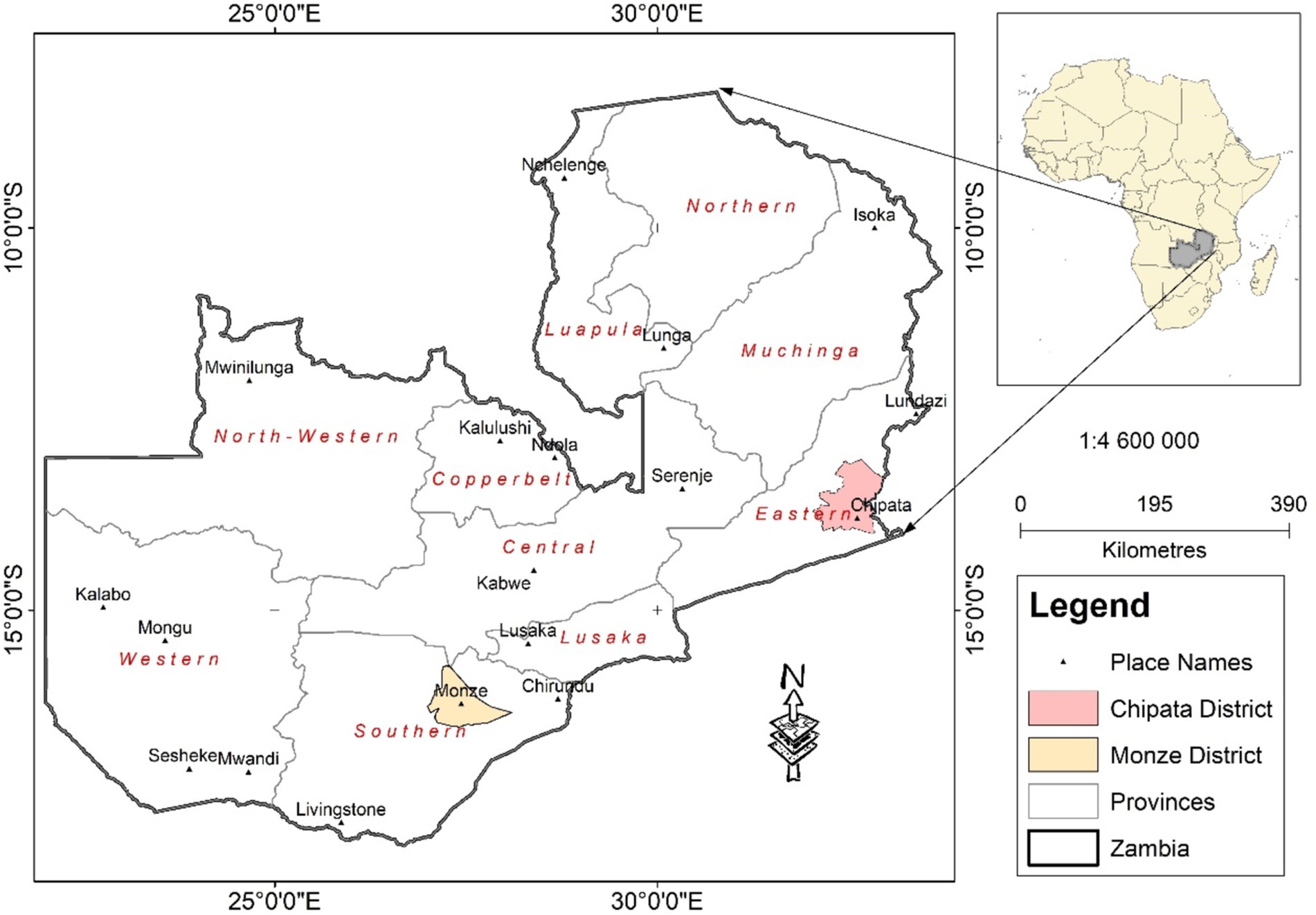
The geospatial irrigation suitability approach was demonstrated in Monze District (Figure 1), a semi-arid district in the Southern Province of Zambia. The district has a total land area of about 6,700 km2 and is predominantly savanna grassland. It is close to the Barotse wetland, the source of the Zambezi River and has abundant surface and groundwater resources, offering great irrigation development potential, which is yet to be tapped. It is often affected by extreme weather events such as prolonged drought periods, severe heatwaves, cyclones and floods, which often contribute to total crop failure (Mwale et al., 2016). These extreme weather events resulted in Zambia declaring a state of emergency due to widespread crop failure caused by the 2022–2023 El Niño induced drought, yet the country is endowed with abundant surface-and ground-water resources.
The semi-arid climate is characterised by low seasonal annual rainfall of about 800 mm, mostly during summer, and an annual mean temperature of about 22°C (Mwale et al., 2016). Potential evapotranspiration oscillates between 600 mm and 1,000 mm, exceeding the available water supply (Foster, 1992). The aridity index oscillates between 0.2 and 0.5, classifying the district as an arid area (Foster, 1992). The harsh climatic conditions compound the food and water insecurity challenges, making irrigation development a priority as the district has abundant freshwater resources. Irrigation development could play a significant role in building the resilience and adaptation to climate change of smallholder farmers.
2.2 Methodological framework
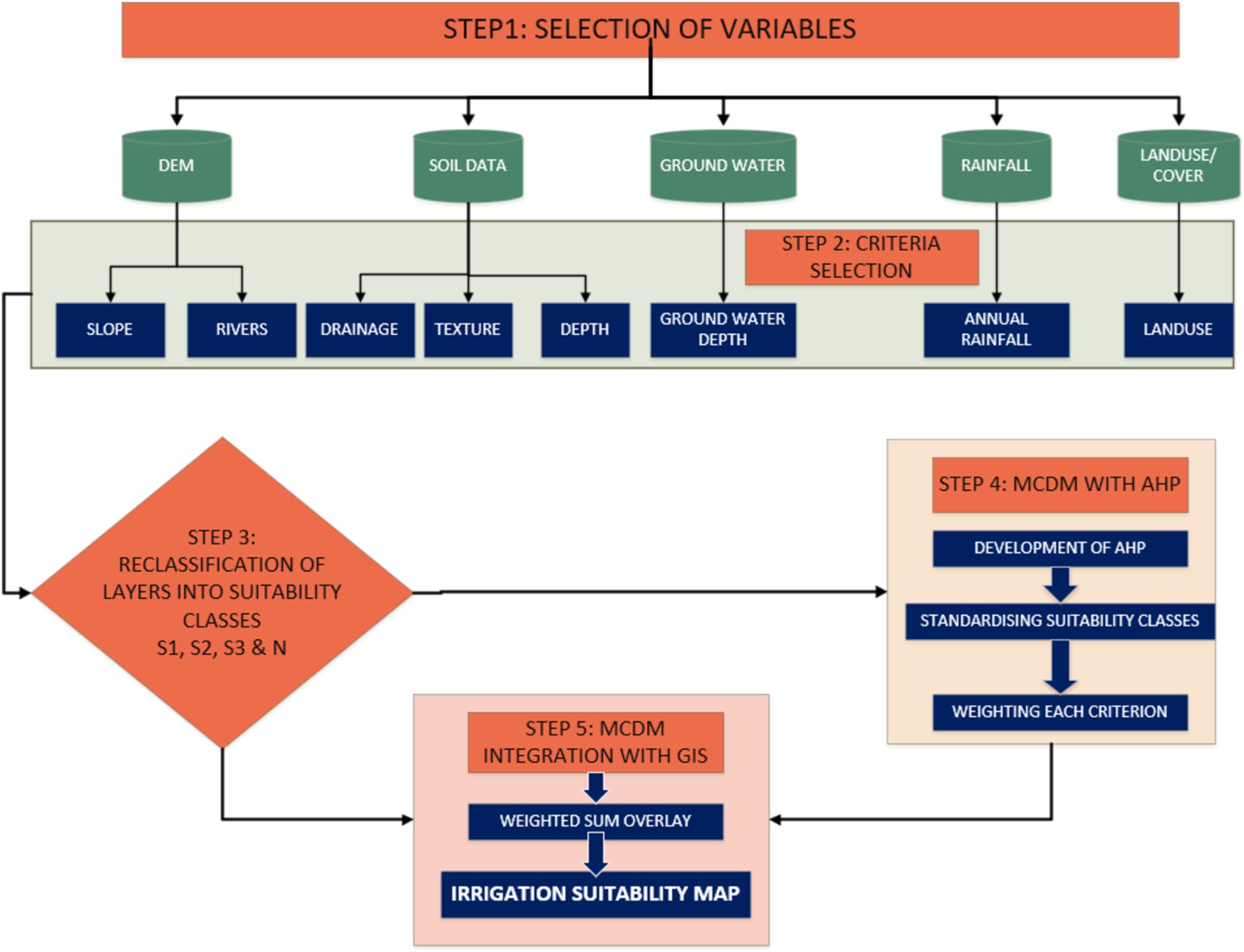
The overall modelling flowchart (Figure 2) is a stepwise process followed to delineate irrigation suitability areas, a replicable procedure at any spatial scale. The five steps of the framework include: (1) Selecting the variables needed to classify land into irrigation suitability areas and the preparation of input data layers, including the digital elevation model (DEM), soil data, surface water, and land-use/cover datasets. (2) Selecting the criteria from the variables, data cleaning, and pre-processing, including conversion of the input data layers into a uniform spatial resolution. (3) Reclassifying the criteria layers and assigning suitability classes according to the FAO classification criteria (S1, S2, S3, and N). (4) Applying the Analytic Hierarchy Process (AHP) as a multi-criteria decision method (MCDM), including the use of the pairwise comparison matrix (PCM) and the weighting of the criteria. The weighting of input layers is based on their unique influence on irrigation suitability. (5) Integrating the MCDM in a Geographic Information System (GIS) to produce an irrigation suitability map. These steps are further detailed in the proceeding sections.
2.3 Criteria/factors for irrigation suitability mapping
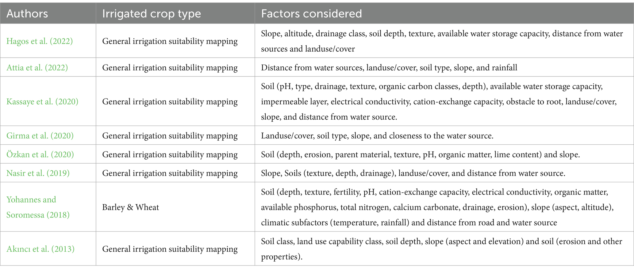
Seven biophysical factors were identified to delineate irrigation suitability areas: slope, rainfall, soil texture, soil drainage, soil depth, closeness to water source (both surface and groundwater), and land use/land cover (Hagos et al., 2022; USDIBR, 2005). The selection of the aptest biophysical factors was based on previous studies that also considered only physical factors, however, applying varying factors including those that should be considered to assess crop-specific irrigation suitability areas (Table 1). However, these previous studies considered only biophysical factors that were fundamental at the time of selecting the aptest factors for a general irrigation suitability mapping. For example, factors that include pH and organic matter content, among others, should be excluded in a general irrigation suitability mapping as the requirement of such factors by crops varies from crop to crop. Some crops require high organic matter content, yet others do well in low organic matter sandy soils, and vice versa. Therefore, if such factors are considered in a general irrigated suitability mapping, the output map will not be representative of all crops.
The selected factors (also known as criteria) are key in irrigation suitability mapping in any given landscape, regardless of economic factors which are considered to indicate optimal areas to initiate irrigation projects from those identified using the biophysical factors (García-Llorente et al., 2015; USDIBR, 2005). Socio-economic factors that include population density, closeness to markets, and proximity to roads, among others, are excluded at this initial stage as they are useful for indicating priority areas for implementing irrigation projects (Elliott et al., 2014; USDIBR, 2005). Economic factors are, therefore, applied to already identified irrigation suitability areas, and do not determine an area’s suitability for irrigation potential (Baker and Capel, 2011; Elliott et al., 2014; USDIBR, 2005). Thus, socio-economic factors are only essential during the second phase of irrigation development and expansion, which is informing policy and decision-makers on optimal areas for immediate irrigation development but do not determine an area’s suitability for irrigation (Elliott et al., 2014; Rossiter, 1996; USDIBR, 2005).
2.3.1 Edaphic factors
Edaphic characteristics required to delineate general irrigation suitability areas include texture, drainage, and depth (USDIBR, 2005). Soil depth anchors plant nutrients and promotes plant growth (Galindo-Castañeda et al., 2022), whereas soil texture, together with drainage determines the rate at which water infiltrates through and runs off causing erosion. Water moves more freely through sandy soils than it does through clayey soils (Bhattacharya et al., 2021; FAO, 1976; Sarwar et al., 2021). Soil texture is also critical for regulating the quantity of water available to the plant and the period it remains in the soil (Schoonover and Crim, 2015). Clay soils have greater water-holding capacity than sandy soils (Leenaars et al., 2018; Schoonover and Crim, 2015). On the other hand, drainage ensures that the soil is properly aerated, an important requirement for root growth and crop health (FAO, 1976).
Other factors related to soil properties such as pH and soil salinity, among others, are excluded in a general irrigation suitability mapping as some crops do well with high pH values whilst others favour low values (Neina, 2019). The same with salinity, some crops do well under saline conditions, while others do not survive at all (Egamberdieva et al., 2019). However, salinity will be considered in future studies. Specific soil properties are applicable when assessing optimal areas for the cultivation of particular crops, as crop growth conditions vary from crop to crop (Tesfahunegn and Gebru, 2020).
2.3.2 Topographic factors
Slope is a key factor in irrigation suitability mapping as it determines the irrigation method, soil erosion susceptibility, soil tillage, and management (USDIBR, 2005). The slope dataset was derived from the 30 m resolution Digital Elevation Model (DEM) from the Terra Advanced Spaceborne Thermal Emission and Reflection Radiometer (SRTM).1
2.3.3 Hydrologic factors
Closeness to water sources (surface and groundwater) is vital for irrigation development as it determines availability (Paul et al., 2020). The Euclidean distance tool of ArcGIS was used to provide the distances from surface water bodies. The accessibility of groundwater was assessed through a groundwater depth dataset (metres below ground level—mbgl) acquired from the British Geological Survey (BGS) (MacDonald et al., 2012). For example, groundwater has become an important source of water for irrigated agriculture in South Africa, particularly during the dry seasons (Nhamo et al., 2020; Siebert et al., 2015).
2.3.4 Landuse/cover
Landuse/cover is considered in irrigation suitability mapping as it eradicates unsuitable areas like built-up areas, waterbodies, and nature reserves, but also optimising the most suitable areas like cultivated lands. The landuse dataset was obtained from the ESRI Land use/cover map created at a spatial resolution of 10 m,2 which was used to map landuses that include cultivated areas, grassland, shrubland, forest land and built-up areas.
2.3.5 Climatic factors
Rainfall recharges waterbodies that are used as sources of water during the dry season. Rainfall is also critical harvested water that will be used later for irrigation purposes during intra-seasonal dry periods (Scanlon et al., 2012; Siebert et al., 2015). Nevertheless, rainfall is weighted the lowest as irrigation is only necessary when there is moisture deficiency during periods. Therefore, the source of water is the waterbodies and not necessarily from rainfall.
2.4 Data collection and sources
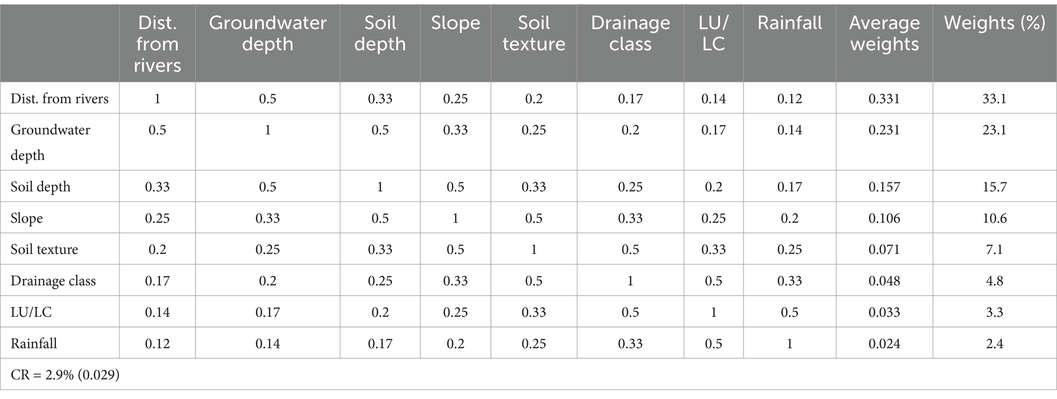
The acquired input datasets (Table 2) were resampled to a uniform spatial resolution, reclassified, and weighted in ArcGIS Pro using the Weighted Overlay tool. The soil dataset was acquired from the Soil and Terrain (SOTER) Digital Database, groundwater depth from BGS, slope and river networks from ASTER GDEM, landuse/cover from the Global Land Cover and rainfall from the Food and Agriculture Organization (FAO). The weights for each of the factors were determined through the pairwise comparison matrix PCM of the AHP (Hagos et al., 2022; Saaty, 1977; Worqlul et al., 2017).
2.5 Application and accuracy assessment
The selected biophysical factors were then applied in an integrated geospatial approach to delineate irrigation suitability areas in Monze District in Zambia, to assess the efficacy of the factors. Fieldwork was conducted in the study area to assess the accuracy of the identified irrigation suitability areas. The accuracy assessment was verified by comparing the generated dataset with six ground truth points obtained from fieldwork, as well as from the 15 m resolution Google Earth images. This was further improved by combining ground-truth points derived from Google Earth with observed field points that enhanced the accuracy assessment of the delineated points. The visual interpretation, coupled with the fieldwork points enhanced the accuracy assessment procedure.
2.6 Criteria/factor classification for irrigation suitability
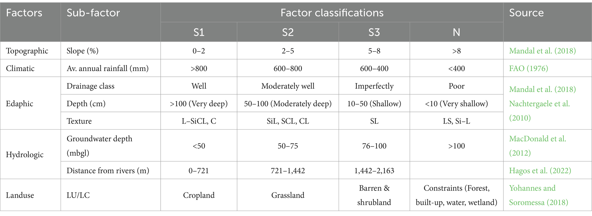
The land suitability classes proposed by the Food and Agricultural Organization (FAO) describe four levels of the suitability of a given type of land for specific use (FAO, 1976; Rossiter, 1996). The FAO classes are highly suitable (S1), moderately suitable (S2), marginally suitable (S3), and not suitable (N) (Table 3).
Criteria layers (maps) are then standardised according to the FAO classes (S1, S2, S3 and N), representing the degree of suitability. Each class is ranked according to its significance in relation to class S1 and its contribution to the final goal of identifying optimal irrigation suitability areas.
2.7 Categorising the irrigated area suitability mapping factors
The selected factors, subfactors and the suitability classes allocated to each of the sub-factors are given in Table 4, which also provides the weights assigned to each of the contributing factors, together with their classes (S1, S2, S3, and S4).
The weights derived from a PCM were assessed through the consistency ratio (CR), which is an indicator of the consistency of the matrix judgments (Saaty, 1977).
2.8 Factor weighting
As the sub-factor layers differ in importance, they are compared with each other through weights and then ranked according to those weights representing their importance to irrigation suitability mapping (Table 5). The calculated weights are then used as input data to the sub-factor layers.
The distance from surface water sources (surface and groundwater) is weighted the highest (Table 5) as closeness to and presence of water source is key to irrigation development. Adequate water supply and availability determine the success of an irrigation system (Levidow et al., 2014). Distance from rivers is ranked the highest as it has less abstraction costs as compared to groundwater. Groundwater depth is assigned the second ranking as it is a major irrigation water source, although it is more expensive to abstract as compared to open water sources (Cai et al., 2017; Magidi et al., 2021a). The third ranking was assigned to the soil depth factor as it gives root anchorage and accessibility to water and nutrients for the crop. The slope factor was given the fourth ranking as it is a determinant of the type of irrigation to be practiced in an irrigated area (Hagos et al., 2022; Worqlul et al., 2017). Soil texture and its drainage are ranked fifth and sixth, respectively, as they are key to plant growth, aeration and water-holding capacity. Landcover/use is ranked seventh as it is only critical for identifying and discarding unsuitable areas like nature and games reserves, waterbodies, and settlements, but also for optimising land areas that are suitable for irrigation such as cultivated lands. The rainfall factor is the least ranked as rainfall is applied only in the absence of rainfall or when there is insufficient crop moisture, However, rainfall is critical for recharging both surface and groundwater sources.
3 Results
3.1 Irrigation suitability area
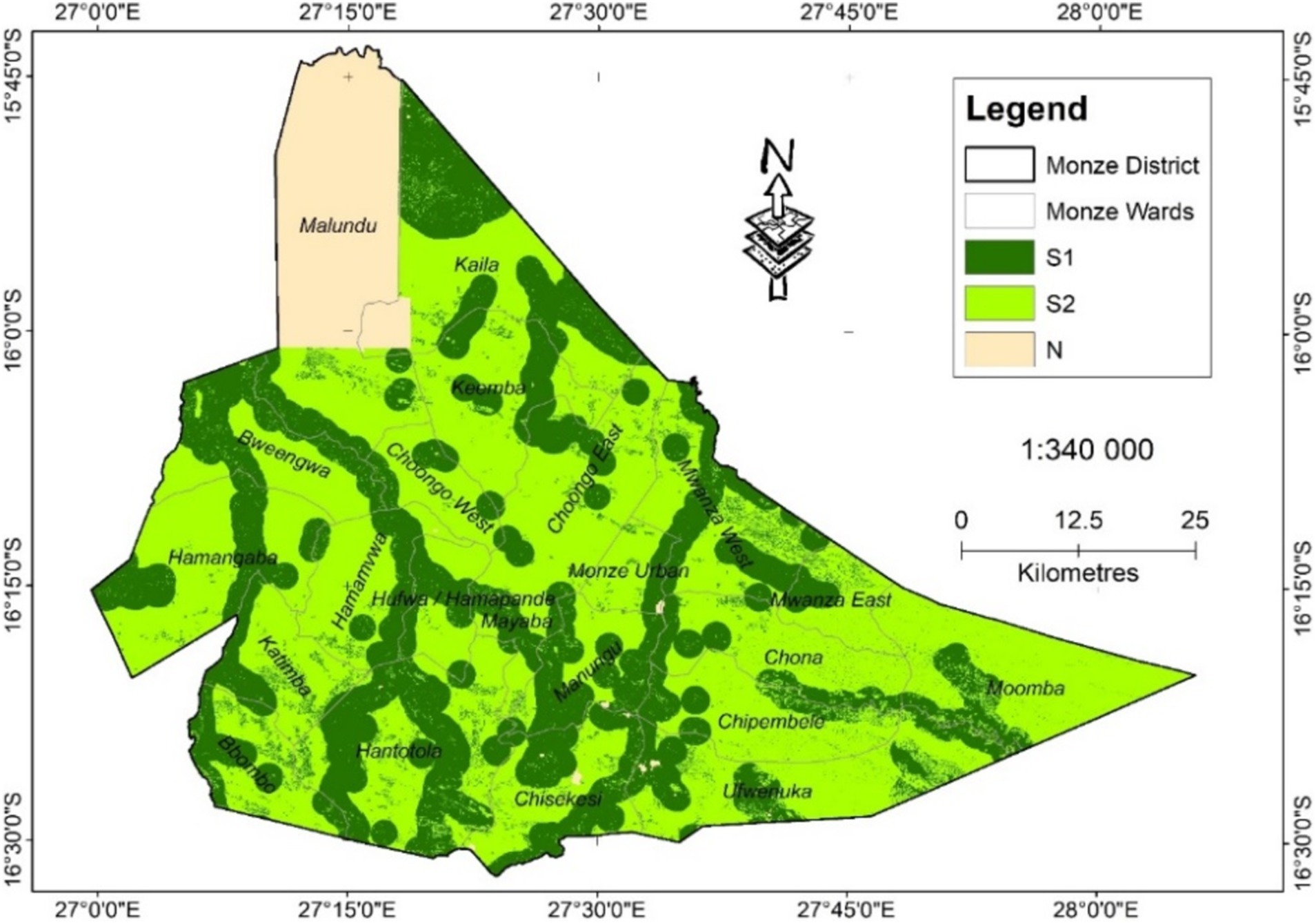
According to the developed map of Monze District (Figure 3) irrigation suitability areas are shaped by proximity to surface water and groundwater depth. Hydrologic factors have the greatest impact in delineating irrigation suitability areas as they are ranked the highest. The further an area is from waterbodies, the greater the possibility of becoming unsuitable for irrigation as the other factors were weighted less, as well as the influence of constraints depicted as not suitable (N) in input layers. As can be noticed in Figure 3, highly suitable areas (S1) are shaped by the river network. Where the shape does not follow the rivers, it indicates that the groundwater table is close to the surface. As areas along rivers are generally irrigated in practice today, this also indicates the accuracy of the mapped irrigated areas, also resulting from fieldwork.
Although the district has a huge nature reserve, it still offers 35.8% of the surface area classified as highly suitable (S1) (Table 6). Even though the district is dry, it has great irrigation potential as it is endowed with abundant surface and groundwater resources. Because of its endowments in surface and groundwater resources, Monze has no area classified as marginally suitable (S3) for irrigation as most of the land area is classified as either S1 or S2. The land that is not suitable (N) is only 8.5% of the total district area, and this is the land area covered by the nature reserve and is excluded from the classification. Thus, 91.5% of the land area is suitable for irrigation.
3.2 Accuracy assessment
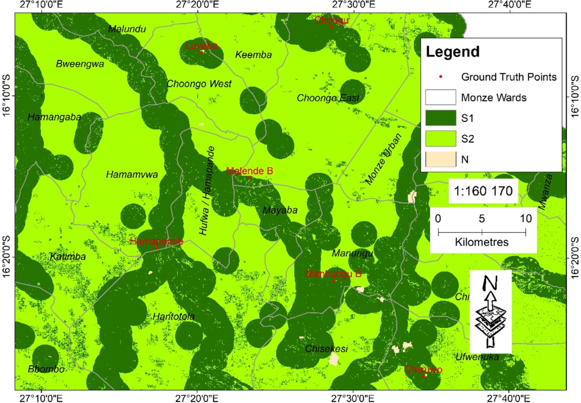
Accuracy was assessed by overlaying ground truthing points collected during fieldwork on the delineated irrigation suitability areas, and all the field points were in S1 class, providing the best possible accuracy of 100%. The ground-truthing points were found to be in the S1 classification category (Figure 4).
The accuracy assessment was enhanced by the use of high-resolution Google Earth images, where some of the mapped irrigatable areas were found to be already irrigated areas. However, there is some land mapped as suitable for irrigation but was not actually irrigated, indicating the irrigation potential of Monze District. The land mapped as irrigable, but not actually irrigated, is the land that can be developed for irrigation.
4 Discussion
Although the land classified as S3 is the least suitable for irrigation, it can be transformed to become important for irrigation by adopting novel land management practices and using correct irrigation types and technologies (Irmak et al., 2011; Reinders, 2011). Recent technological advances in irrigation have been used to transform areas formerly deemed unsuitable for irrigation into viable irrigation enterprises (Koech and Langat, 2018; Levidow et al., 2014). This has been enhanced by land restoration and reclamation, which have been beneficial in regions where land is extensively degraded or scarce to support agricultural development (Vera et al., 2021; Zinkernagel et al., 2020). This has been one of the goals of the geospatial irrigation suitability approach used in this study as it has facilitated an assessment of the long-term impacts of land suitability analysis on potential land productivity.
An irrigation suitability assessment is useful for strategic policy decisions on irrigation development and for guiding the efficient use and management of scarce water resources (Borsato et al., 2020). Although irrigated agriculture has important socio-economic and ecological benefits including increasing crop water productivity, ensuring food and water security, enhancing climate change adaptation and resilience, and improving rural livelihoods, it also has some known trade-offs. If not well planned and managed, irrigation could result in adverse human and environmental health consequences including disturbing the terrestrial water cycle and causing the spread of vector-borne diseases (Magidi et al., 2021b).
Knowledge of the distribution and extent of irrigation, together with irrigation water requirements, is critical for modelling and allocating irrigation water, and quantifying the impact of irrigation on regional climate, river discharge, and groundwater depletion (Borsato et al., 2020). Therefore, knowledge of irrigated areas provides the required information on irrigation development strategies and is a climate change adaptation strategy. However, the unavailability of input data for irrigation suitability mapping has been a major challenge.
Equally important in irrigation suitability mapping is the selection of the appropriate factors. It is essential to understand the role of each of both physical and socio-economic factors in irrigation suitability mapping. Physical factors qualify the suitability of an area for irrigation, whereas socio-economic factors form part of conditions set to indicate optimal areas to implement irrigation projects under a set of given economic conditions (FAO, 1976; USDIBR, 2005). This study identified irrigation suitability areas under a set of biophysical factors regardless of whether it is close or far from markets and roads, and economic factors that are considered for initiating irrigation projects (USDIBR, 2005).
The availability of good and high-resolution data is the biggest challenge when conducting such a study. However, the emergence of cloud-based big data platforms like the Google Earth Engine (GEE), coupled with machine learning algorithms like the XGBoost and the Random Forest are facilitating the application of such methods and the acquisition and processing of complex data.
Irrigation investment is identified as key to enhancing and maintaining sustainable food security as it improves agricultural production, which is the foundation for southern Africa’s economic growth, food security, and sustainable development. Sustainable irrigation development and policies should consider the following to achieve the desired outcomes:
• The actual implementation of irrigation projects needs to acknowledge the interlinkages between suitability constraints that include water quality, human and environmental health, and economic and social factors with sustainable development.
• Advances in GIS and remote sensing are facilitating systematic land suitability assessment over time, as well as the delineation of updated land use and irrigation land suitability for sustainable resource planning and management.
• Policy-makers should be aware that accurate spatial information on irrigation statistics is not only important for irrigation development, management, and planning but is also beneficial for economic growth and for informing future needs including meeting future land, water, and food demands.
5 Conclusion
Irrigation suitability classification is important for landuse planning in relation to agricultural potential and is required for conserving natural resources to meet the needs of future generations. Accurate delineation of irrigation suitability areas and other land suitability classifications is only possible through the understanding and selection of appropriate land characteristics of the suitability theme being reviewed. In the case of irrigation suitability mapping, only physical factors were used as input layers to delineate the most apt areas suitable for irrigation. The method used distinguished biophysical and socio-economic factors as the two sets of factors contribute differently to land suitability mapping. Physical factors are critical for identifying land parcels that are suitable for irrigation in space and time, however, socio-economic factors are important for pin-pointing optimal irrigable areas to start irrigation projects under a set of given socio-economic conditions. The results of this study and the selection of ideal physical factors for delineating irrigation suitability areas have improved the identification of areas that are suitable for irrigation. Distinguishing physical and socio-economic factors has facilitated the use of each of the set of factors in their real use in irrigation development and expansion. The procedure has improved irrigation suitability mapping as past studies combined both factors in a general irrigation suitability mapping. Most areas that are suitable for irrigation were eliminated or classified as unsuitable as a result. The current approach is applicable at any spatial scale. Accurate mapping of irrigation suitability mapping is essential for guiding strategic policy decisions on sustainable irrigation planning. The adopted approach and the results are essential for designing and initiating new irrigation projects by providing a reliable technique that informs future irrigation development. The approach used is replicable at any spatial scale and is adaptable to suit the data availability of any area.
Data availability statement
The original contributions presented in the study are included in the article/supplementary material, further inquiries can be directed to the corresponding author.
Author contributions
LN: Conceptualization, Formal analysis, Funding acquisition, Investigation, Methodology, Resources, Writing – original draft, Writing – review & editing. JM: Data curation, Formal analysis, Investigation, Methodology, Validation, Writing – review & editing. SM: Funding acquisition, Investigation, Resources, Supervision, Validation, Writing – review & editing. SL: Funding acquisition, Investigation, Methodology, Resources, Supervision, Writing – review & editing. TM: Conceptualization, Formal analysis, Investigation, Methodology, Resources, Validation, Writing – review & editing.
Funding
The author(s) declare that financial support was received for the research, authorship, and/or publication of this article. We declare that our work has been funded by the Water Research Commission of South Africa (WRC) under the Research, Development, and Innovation (RDI) Branch (RDI 2024).
Conflict of interest
The authors declare that the research was conducted in the absence of any commercial or financial relationships that could be construed as a potential conflict of interest.
The author(s) declared that they were an editorial board member of Frontiers, at the time of submission. This had no impact on the peer review process and the final decision.
Publisher’s note
All claims expressed in this article are solely those of the authors and do not necessarily represent those of their affiliated organizations, or those of the publisher, the editors and the reviewers. Any product that may be evaluated in this article, or claim that may be made by its manufacturer, is not guaranteed or endorsed by the publisher.
Footnotes
References
Ahsan, D., Brandt, U. S., and Faruque, H. (2021). Local agricultural practices to adapt with climate change. Is sustainability a priority? Curr. Res. Environ. Sustain. 3:100065. doi: 10.1016/j.crsust.2021.100065
Akıncı, H., Özalp, A. Y., and Turgut, B. (2013). Agricultural land use suitability analysis using GIS and AHP technique. Comput. Electron. Agric. 97, 71–82. doi: 10.1016/j.compag.2013.07.006
Akpoti, K., Higginbottom, T. P., Foster, T., Adhikari, R., and Zwart, S. J. (2022). Mapping land suitability for informal, small-scale irrigation development using spatial modelling and machine learning in the upper east region, Ghana. Sci. Total Environ. 803:149959. doi: 10.1016/j.scitotenv.2021.149959
Attia, A., Qureshi, A. S., Kane, A. M., Alikhanov, B., Kheir, A. M., Ullah, H., et al. (2022). Selection of potential sites for promoting small-scale irrigation across Mali using remote sensing and GIS. Sustain. For. 14:12040. doi: 10.3390/su141912040
AU (2014). Malabo declaration on accelerated agricultural growth and transformation for shared prosperity and improved livelihoods. Adis Ababa, Ethiopia: African Union (AU), 12.
Baker, N. T., and Capel, P. D. (2011). Environmental factors that influence the location of crop agriculture in the conterminous United States. Reston, VA, USA: US Department of the Interior, US Geological Survey.
Barbier, E. B., and Hochard, J. P. (2018). Land degradation and poverty. Nat. Sustain. 1, 623–631. doi: 10.1038/s41893-018-0155-4
Bhattacharya, S., Das, S., Das, S., Kalashetty, M., and Warghat, S. R. (2021). An integrated approach for mapping groundwater potential applying geospatial and MIF techniques in the semiarid region. Environ. Dev. Sustain. 23, 495–510. doi: 10.1007/s10668-020-00593-5
Borsato, E., Rosa, L., Marinello, F., Tarolli, P., and D'Odorico, P. (2020). Weak and strong sustainability of irrigation: a framework for irrigation practices under limited water availability. Front. Sustain. Food Syst. 4:17. doi: 10.3389/fsufs.2020.00017
Cai, X., Magidi, J., Nhamo, L., and van Koppen, B. (2017). Mapping irrigated areas in the Limpopo Province, South Africa. Colombo, Sri Lanka: International Water Management Institute (IWMI), 42.
Calicioglu, O., Flammini, A., Bracco, S., Bellù, L., and Sims, R. (2019). The future challenges of food and agriculture: an integrated analysis of trends and solutions. Sustain. For. 11:222. doi: 10.3390/su11010222
Egamberdieva, D., Wirth, S., Bellingrath-Kimura, S. D., Mishra, J., and Arora, N. K. (2019). Salt-tolerant plant growth promoting rhizobacteria for enhancing crop productivity of saline soils. Front. Microbiol. 10:2791. doi: 10.3389/fmicb.2019.02791
Elliott, J., Deryng, D., Müller, C., Frieler, K., Konzmann, M., Gerten, D., et al. (2014). Constraints and potentials of future irrigation water availability on agricultural production under climate change. Proc. Natl. Acad. Sci. 111, 3239–3244. doi: 10.1073/pnas.1222474110
FAO (1976). A framework for land evaluation. Rome, Italy: Food and Agriculture Organization of the United Nations (FAO).
Galindo-Castañeda, T., Lynch, J. P., Six, J., and Hartmann, M. (2022). Improving soil resource uptake by plants through capitalizing on synergies between root architecture and anatomy and root-associated microorganisms. Front. Plant Sci. 13:827369. doi: 10.3389/fpls.2022.827369
García-Llorente, M., Iniesta-Arandia, I., Willaarts, B. A., Harrison, P. A., Berry, P., del Mar Bayo, M., et al. (2015). Biophysical and sociocultural factors underlying spatial trade-offs of ecosystem services in semiarid watersheds. Ecol. Soc. 20:39. doi: 10.5751/ES-07785-200339
Girma, R., Gebre, E., and Tadesse, T. (2020). Land suitability evaluation for surface irrigation using spatial information technology in Omo-Gibe River Basin, Southern Ethiopia. Irrig. Drain. Syst. Eng. 9:1. doi: 10.37421/idse.2020.9.245
Hagos, Y. G., Mengie, M. A., Andualem, T. G., Yibeltal, M., Linh, N. T. T., Tenagashaw, D. Y., et al. (2022). Land suitability assessment for surface irrigation development at Ethiopian highlands using geospatial technology. Appl Water Sci 12, 1–11. doi: 10.1007/s13201-022-01618-2
Irmak, S., Odhiambo, L. O., Kranz, W. L., and Eisenhauer, D. E. (2011). Irrigation efficiency and uniformity, and crop water use efficiency. Lincoln, Nebraska: Biological Systems Engineering, University of Nebraska, 9.
Kaini, S., Gardner, T., and Sharma, A. K. (2020). Assessment of socio-economic factors impacting on the cropping intensity of an irrigation scheme in developing countries. Irrig. Drain. 69, 363–375. doi: 10.1002/ird.2427
Kassaye, K. T., Boulange, J., Saito, H., and Watanabe, H. (2020). Monitoring soil water content for decision supporting in agricultural water management based on critical threshold values adopted for andosol in the temperate monsoon climate. Agric. Water Manag. 229:105930. doi: 10.1016/j.agwat.2019.105930
Koech, R., and Langat, P. (2018). Improving irrigation water use efficiency: a review of advances, challenges and opportunities in the Australian context. Water 10:1771. doi: 10.3390/w10121771
Lambin, E. F., and Meyfroidt, P. (2011). Global land use change, economic globalization, and the looming land scarcity. Proc. Natl. Acad. Sci. 108, 3465–3472. doi: 10.1073/pnas.1100480108
Lampert, A. (2019). Over-exploitation of natural resources is followed by inevitable declines in economic growth and discount rate. Nat. Commun. 10, 1–10. doi: 10.1038/s41467-019-09246-2
Leenaars, J. G., Claessens, L., Heuvelink, G. B., Hengl, T., González, M. R., van Bussel, L. G., et al. (2018). Mapping rootable depth and root zone plant-available water holding capacity of the soil of sub-Saharan Africa. Geoderma 324, 18–36. doi: 10.1016/j.geoderma.2018.02.046
Levidow, L., Zaccaria, D., Maia, R., Vivas, E., Todorovic, M., and Scardigno, A. (2014). Improving water-efficient irrigation: prospects and difficulties of innovative practices. Agric. Water Manag. 146, 84–94. doi: 10.1016/j.agwat.2014.07.012
Mabhaudhi, T., Haileslassie, A., Magidi, J., and Nhamo, L. (2022). Irrigation suitability mapping examples from Zimbabwe, Zambia, Malawi and Kenya. Colombo, Sri Lanka: International Water Management Institute (IWMI), 52.
MacDonald, A. M., Bonsor, H. C., Dochartaigh, B. É. Ó., and Taylor, R. G. (2012). Quantitative maps of groundwater resources in Africa. Environ. Res. Lett. 7:024009. doi: 10.1088/1748-9326/7/2/024009
Magidi, J., Nhamo, L., Mpandeli, S., and Mabhaudhi, T. (2021a). Application of the random forest classifier to map irrigated areas using Google earth engine. Remote Sens. 13:876. doi: 10.3390/rs13050876
Magidi, J., van Koppen, B., Nhamo, L., Mpandeli, S., Slotow, R., and Mabhaudhi, T. (2021b). Informing equitable water and food policies through accurate spatial information on irrigated areas in smallholder farming systems. Water 13:3627. doi: 10.3390/w13243627
Mandal, B., Dolui, G., and Satpathy, S. (2018). Land suitability assessment for potential surface irrigation of river catchment for irrigation development in Kansai watershed, Purulia, West Bengal, India. Sustain. Water Resour. Manag. 4, 699–714. doi: 10.1007/s40899-017-0155-y
Mango, N., Makate, C., Tamene, L., Mponela, P., and Ndengu, G. (2018). Adoption of small-scale irrigation farming as a climate-smart agriculture practice and its influence on household income in the Chinyanja triangle, Southern Africa. Land 7:49. doi: 10.3390/land7020049
Mugiyo, H., Chimonyo, V. G., Sibanda, M., Kunz, R., Masemola, C. R., Modi, A. T., et al. (2021). Evaluation of land suitability methods with reference to neglected and underutilised crop species: a scoping review. Land 10:125. doi: 10.3390/land10020125
Mwale, J. T., Lichilo, I., and Muyangwa, M. (2016). The farmer response to conservation agriculture in Monze, Zambia. World J. Res. Rev. 3:262901. doi: 10.31871/WJRR.3.2.33
Nachtergaele, F., van Velthuizen, H., Verelst, L., Batjes, N., Dijkshoorn, K., van Engelen, V., et al. (2010). The harmonized world soil database. Proceedings of the 19th world congress of soil science, soil solutions for a changing world, Brisbane, Australia, pp. 34–37.
Nasir, G., Tamane, A., and Tolera, D. (2019). Irrigation potential assessment on Shaya river sub-basin in bale zone, Oromia region, Ethiopia. Irrig. Drain. Syst. Eng. 8:7. doi: 10.4172/2168-9768.1000225
Neina, D. (2019). The role of soil pH in plant nutrition and soil remediation. Appl. Environ. Soil Sci. 2019, 1–9. doi: 10.1155/2019/5794869
NEPAD (2003). Comprehensive Africa agriculture development programme (CAADP). Midrand, South Africa: New Partnership for Africa’s development (NEPAD), 116.
Nhamo, L., Ebrahim, G. Y., Mabhaudhi, T., Mpandeli, S., Magombeyi, M., Chitakira, M., et al. (2020). An assessment of groundwater use in irrigated agriculture using multi-spectral remote sensing. Phys. Chem. Earth Parts A/B/C 115:102810. doi: 10.1016/j.pce.2019.102810
Nhamo, L., Mpandeli, S., Liphadzi, S., and Mabhaudhi, T. (2022). Securing land and water for food production through sustainable land reform: a Nexus planning perspective. Land 11:974. doi: 10.3390/land11070974
Nhemachena, C., Nhamo, L., Matchaya, G., Nhemachena, C. R., Muchara, B., Karuaihe, S. T., et al. (2020). Climate change impacts on water and agriculture sectors in southern Africa: threats and opportunities for sustainable development. Water 12:2673. doi: 10.3390/w12102673
Özkan, B., Dengiz, O., and Turan, İ. D. (2020). Site suitability analysis for potential agricultural land with spatial fuzzy multi-criteria decision analysis in regional scale under semi-arid terrestrial ecosystem. Sci. Rep. 10:22074. doi: 10.1038/s41598-020-79105-4
Paul, M., Negahban-Azar, M., Shirmohammadi, A., and Montas, H. (2020). Assessment of agricultural land suitability for irrigation with reclaimed water using geospatial multi-criteria decision analysis. Agric. Water Manag. 231:105987. doi: 10.1016/j.agwat.2019.105987
Pawlak, K., and Kołodziejczak, M. (2020). The role of agriculture in ensuring food security in developing countries: considerations in the context of the problem of sustainable food production. Sustain. For. 12:5488. doi: 10.3390/su12135488
Raza, A., Razzaq, A., Mehmood, S. S., Zou, X., Zhang, X., Lv, Y., et al. (2019). Impact of climate change on crops adaptation and strategies to tackle its outcome: a review. Plan. Theory 8:34. doi: 10.3390/plants8020034
Reinders, F. B. (2011). Irrigation methods for efficient water application: 40 years of South African research excellence. Water SA 37, 765–770. doi: 10.4314/wsa.v37i5.13
Rossiter, D. G. (1996). A theoretical framework for land evaluation. Geoderma 72, 165–190. doi: 10.1016/0016-7061(96)00031-6
Ruiz, I., Almagro, M., de Jalón, S. G., del Mar Solà, M., and Sanz, M. J. (2020). Assessment of sustainable land management practices in Mediterranean rural regions. J. Environ. Manag. 276:111293. doi: 10.1016/j.jenvman.2020.111293
Saaty, T. L. (1977). A scaling method for priorities in hierarchical structures. J. Math. Psychol. 15, 234–281. doi: 10.1016/0022-2496(77)90033-5
Sarwar, A., Ahmad, S. R., Rehmani, M. I. A., Asif Javid, M., Gulzar, S., Shehzad, M. A., et al. (2021). Mapping groundwater potential for irrigation, by geographical information system and remote sensing techniques: a case study of district lower Dir, Pakistan. Atmosphere 12:669. doi: 10.3390/atmos12060669
Scanlon, B. R., Faunt, C. C., Longuevergne, L., Reedy, R. C., Alley, W. M., McGuire, V. L., et al. (2012). Groundwater depletion and sustainability of irrigation in the US High Plains and Central Valley. Proc. Natl. Acad. Sci. 109, 9320–9325. doi: 10.1073/pnas.1200311109
Schoonover, J. E., and Crim, J. F. (2015). An introduction to soil concepts and the role of soils in watershed management. J. Contemp. Water Res. Educ. 154, 21–47. doi: 10.1111/j.1936-704X.2015.03186.x
Sebnie, W., Adgo, E., and Kendie, H. (2020). Irrigation suitability evaluation of Zamra irrigation scheme, Abergele district of wag-himra zone, Amhara region Ethiopia. Environ. Syst. Res. 9, 1–9. doi: 10.1186/s40068-020-00200-6
Serote, B., Mokgehle, S., Du Plooy, C., Mpandeli, S., Nhamo, L., and Senyolo, G. (2021). Factors influencing the adoption of climate-smart irrigation technologies for sustainable crop productivity by smallholder farmers in arid areas of South Africa. Agriculture 11:1222. doi: 10.3390/agriculture11121222
Siebert, S., Kummu, M., Porkka, M., Döll, P., Ramankutty, N., and Scanlon, B. R. (2015). A global data set of the extent of irrigated land from 1900 to 2005. Hydrol. Earth Syst. Sci. 19, 1521–1545. doi: 10.5194/hess-19-1521-2015
Tesfahunegn, G. B., and Gebru, T. A. (2020). Variation in soil properties under different cropping and other land-use systems in dura catchment, Northern Ethiopia. PLoS One 15:e0222476. doi: 10.1371/journal.pone.0222476
Uhlenbrook, S., Yu, W., Schmitter, P., and Smith, D. M. (2022). Optimising the water we eat—rethinking policy to enhance productive and sustainable use of water in Agri-food systems across scales. Lancet Planet. Health 6, e59–e65. doi: 10.1016/S2542-5196(21)00264-3
UNGA (2015). Transforming our world: the 2030 agenda for sustainable development, resolution adopted by the General Assembly (UNGA). New York, USA: United Nations General Assembly, 35.
USDIBR (2005). Technical guidelines for irrigation suitability land classification united state development of the interior Bureau of Reclamation (USDIBR). Denver, Colorado, USA: Technical Service Center, Land Suitability and Water Quality Group, 236.
Vera, J., Conejero, W., Mira-García, A. B., Conesa, M. R., and Ruiz-Sánchez, M. C. (2021). Towards irrigation automation based on dielectric soil sensors. J. Hortic. Sci. Biotechnol. 96, 696–707. doi: 10.1080/14620316.2021.1906761
Viana, C. M., Freire, D., Abrantes, P., Rocha, J., and Pereira, P. (2022). Agricultural land systems importance for supporting food security and sustainable development goals: a systematic review. Sci. Total Environ. 806:150718. doi: 10.1016/j.scitotenv.2021.150718
Worqlul, A. W., Jeong, J., Dile, Y. T., Osorio, J., Schmitter, P., Gerik, T., et al. (2017). Assessing potential land suitable for surface irrigation using groundwater in Ethiopia. Appl. Geogr. 85, 1–13. doi: 10.1016/j.apgeog.2017.05.010
Yohannes, H., and Soromessa, T. (2018). Land suitability assessment for major crops by using GIS-based multi-criteria approach in Andit Tid watershed, Ethiopia. Cogent Food Agric. 4:1470481. doi: 10.1080/23311932.2018.1470481
Keywords: land suitability, irrigation potential, multi-criteria decision, crop productivity, drought risk reduction, adaptation, food and water security, sustainable agriculture
Citation: Nhamo L, Magidi J, Mpandeli S, Liphadzi S and Mabhaudhi T (2024) An integrated geospatial approach and the factors required to delineate irrigation suitability areas. Front. Sustain. Food Syst. 8:1469474. doi: 10.3389/fsufs.2024.1469474
Edited by:
Miguel Felipe Acevedo, University of North Texas, United StatesReviewed by:
Wang Xiukang, Yan’an University, ChinaYameng Wang, Qufu Normal University, China
Waed Alshoubaki, The University of Jordan, Jordan
Copyright © 2024 Nhamo, Magidi, Mpandeli, Liphadzi and Mabhaudhi. This is an open-access article distributed under the terms of the Creative Commons Attribution License (CC BY). The use, distribution or reproduction in other forums is permitted, provided the original author(s) and the copyright owner(s) are credited and that the original publication in this journal is cited, in accordance with accepted academic practice. No use, distribution or reproduction is permitted which does not comply with these terms.
*Correspondence: Luxon Nhamo, bHV4b25uQHdyYy5vcmcuemE=
 Luxon Nhamo
 James Magidi
 Sylvester Mpandeli1,4,5
 Tafadzwanashe Mabhaudhi