- 1College of Land and Resources, Hebei Agricultural University, Baoding, China
- 2Research Center of Local Culture and Rural Governance, Hebei Agricultural University, Baoding, China
- 3Key Laboratory for Farmland Eco-environment of Hebei Province, Hebei Agricultural University, Baoding, China
- 4College of Resources and Environmental Sciences, Hebei Agricultural University, Baoding, China
Introduction: The objective of this study is to investigate the impact of land use changes on the coupling coordination of the regional water-food-carbon system in Hebei Province. Moreover, the findings aim to offer insights for achieving comprehensive and coordinated development of regional resources.
Methods: By constructing an evaluation index system of the coupled coordinated development of the water-food-carbon system, using the coupled coordination model to study the coupled coordination of the water-food-carbon (WFC) system in Hebei Province from 2010 to 2020, and applying the Pearson correlation coefficient and ArcGIS to analyze the impacts of land-use changes on the degree of coupled coordination.
Results: The results show that: (1) The most notable characteristics of land type changes include a decrease in cropland and an increase in construction land, primarily driven by the conversion of cropland to construction sites. The total area converted amounts to 8207.20 km2. (2) The degree of coupled coordination of the water-food-carbon system in the study area as a whole shows an upward and then downward trend, and shows a spatial distribution pattern of “high in the north-east and low in the south-west”; (3) In Hebei Province, the degree of coupling coordination within the water-food-carbon system exhibits a stable positive correlation with forest land, grassland, and water area. Additionally, the transfer of forest land and grassland are significant factors influencing the delineation of cold and hot spots within the region.
Discussion: Therefore, in addressing the coordinated development of the water-food-carbon system, it is essential to consider the influence of land. Resources should be allocated judiciously based on regional advantages to promote sustainable development effectively.
1 Introduction
Water, food, carbon, and land are the key elements closely related to human activities in the Earth’s surface system. Among them, land, water, and food are the essential supply resources in production and life, which can provide important ecosystem service functions for human beings. As one of the key factors of regional economic society and production process, carbon is also closely connected to the development process of many resources. With the rapid increase of the global population, climate change, environmental pollution, and other problems emerge in an endless stream; human lifestyle has also changed and the global warming trend caused by massive greenhouse gas emissions is continuing, which has seriously threatened the balance of natural ecosystems and human health and survival. In this global context, with nearly 20% of the world’s annual greenhouse gasses currently coming from agriculture and land use (Chen et al., 2023). The global demand for water and food is constantly increasing; existing statistics show that in the past 50 years, the global per capita occupancy of water resources and cropland resources decreased by 20–40% (Endo et al., 2017), but in the next 20 years, human demand for them will increase by 30–50% (Kaddoura and El Khatib, 2017). Therefore, the study on the coupling of “water–food–carbon” is not only a timely response to these challenges but also an opportunity to help comprehensively assess the potential of regional human activities to cope with carbon emission reduction. It is also of great significance in promoting resource conservation and improving production efficiency, reducing the intensity of various types of resource depletion, and exploring the regional low-carbon and sustainable development model.
Resources such as food, energy, water, and land are essential to human life and advancement. However, the lack of resource availability and ecological damage has led scholars to recognize the inadequacy of single-resource and binary resource system management models and the need to incorporate more resource systems into joint management strategies in areas where resource availability is limited (Beekma et al., 2021). As a result, research on the water–energy–food triple linkage system has been carried out (Liu and Zhao, 2022; Zhang et al., 2022). Since 2011, when the triad of water, energy, and food security was first proposed as a nexus (Chen and Yan, 2020), the Food and Agriculture Organization of the United Nations (FAO), the International Renewable Energy Agency (IRENA), and other organizations have published reports on the water, energy, and food (WEF) system nexus. At present, domestic and international studies in this area focuses on the concept and content (Conway et al., 2015; Li et al., 2018; Zhan et al., 2014), quantitative assessment of the water–energy–food system (Bai and Zhang, 2018; Mahjabin et al., 2020; Sun and Yan, 2018) and simulation and prediction research (Momblanch et al., 2019; Peng et al., 2017; Wang et al., 2019). More diversified in terms of research methodology, such as the indicator system method (He and Yuan, 2021; Wang and Ye, 2022), coupled coordination degree model (Wang et al., 2024), correlation analysis (Deng et al., 2020), data envelopment analysis (Li et al., 2017), multisubject model analysis (Khan et al., 2017), system dynamics (Wicaksono and Kang, 2019), collaborative optimization model construction (Peng et al., 2017), etc. Spatial differentiation of resource coupling relationships is mostly studied with the help of the coupling cooperation index (Li and Zhang, 2020; Zhi et al., 2020), data envelopment analysis method (Han et al., 2020; Ibrahim et al., 2019; Sun et al., 2021), principal component analysis (Bai and Zhang, 2018) and other methods, which are used to compare the efficiency of water–energy–food resource coupling (Han et al., 2020; Ibrahim et al., 2019; Sun et al., 2021), the level of pressure on supply and demand (Deng et al., 2020), and the degree of security in different geographical regions (Gai and Zhai, 2021; Wang et al., 2018). At present, a large number of studies on water–energy–food systems have been carried out by scholars at home and abroad at different scales., and the existing research focuses on large-scale and mesoscale, such as national scales (Wang and Tian, 2022), watershed scales (Qin and Tong, 2021; Zhao et al., 2021), and specific regions (Bakhshianlamouki et al., 2020). Other scholars have found that the level of coordinated development and time–series evolution characteristics between water–energy–food systems at the urban scale (Dang et al., 2020; Ding et al., 2023; Wang et al., 2020; Wang et al., 2021; Wang and Ye, 2022). In addition, some scholars have also considered factors other than the water–energy–food system, such as studying WEF security in light of global climate change (Bach et al., 2016), incorporating land into the water–energy–food system, finding ways to develop more sustainably in the Beijing–Tianjin–Hebei urban agglomeration (Wang and Sun, 2022), and constructing a network of causal linkages of the water–energy–food system that includes social, economic and environmental subsystems (Li et al., 2016), and so on. In addition, carbon emission—as one of the important factors affecting ecosystem services—is also intimately related to WEF production processes. For example, by considering the “water–land–energy–carbon” linkage, we constructed an input–output measurement index of carbon emission efficiency in agriculture and industry. We concluded that the overuse of land resources is the primary factor influencing the efficiency of carbon emission in agriculture (Jiang et al., 2020). The relationship between food security and water, food, energy, and land was identified using system dynamics, and quantitatively calculated carbon dioxide emissions from various types of resources, and provided a reference for carbon emission reduction in rice cultivation in Japan (Lee et al., 2018). Summarizing the results of existing research shows that there are studies on “water–food” (Jin, 2019), “water–carbon” (Cao et al., 2020), and “food–carbon” (Li et al., 2022) coupling aspects, but lack of a systematic view of water, food, and carbon into a unified framework of research perspective.
Hebei Province, recognized as a primary grain-producing region in China, possesses abundant cropland resources. However, the province faces challenges due to its high total energy consumption and an energy structure predominantly reliant on coal, resulting in significant carbon emissions that rank among the highest in the country. As a chief food-producing area and a high-energy-consuming region, Hebei has historically supplied essential resources to Beijing and Tianjin. This intense resource flow can lead to imbalances within the regional resource system. Consequently, this study has chosen Hebei Province as the focus area for analysis. The main objectives of the study are (1) to investigate the features of land usage and how it has changed over time and space in Hebei Province for the periods 2010, 2015, and 2020; (2) to analyze the characteristics of the spatial and temporal evolution of the coupling coordination of the water-food-carbon system by constructing a system of indicators for evaluating the development of the coupled system; and (3) to explore the impacts of volume and spatial changes in land use on the coupling coherence of “water–food–carbon” system, and deeply reveal the correlation between land-use changes and the spatial and temporal changes in the coupling coordination of the system. The innovation of the study is to incorporate water–food–carbon into a unified framework to explore the impact of land-use change on the coupled coordination of the water-food-carbon system and to explore how to enhance the coordination of the overall resource allocation in the region through the rational use of land.
2 Materials and methods
2.1 Study area
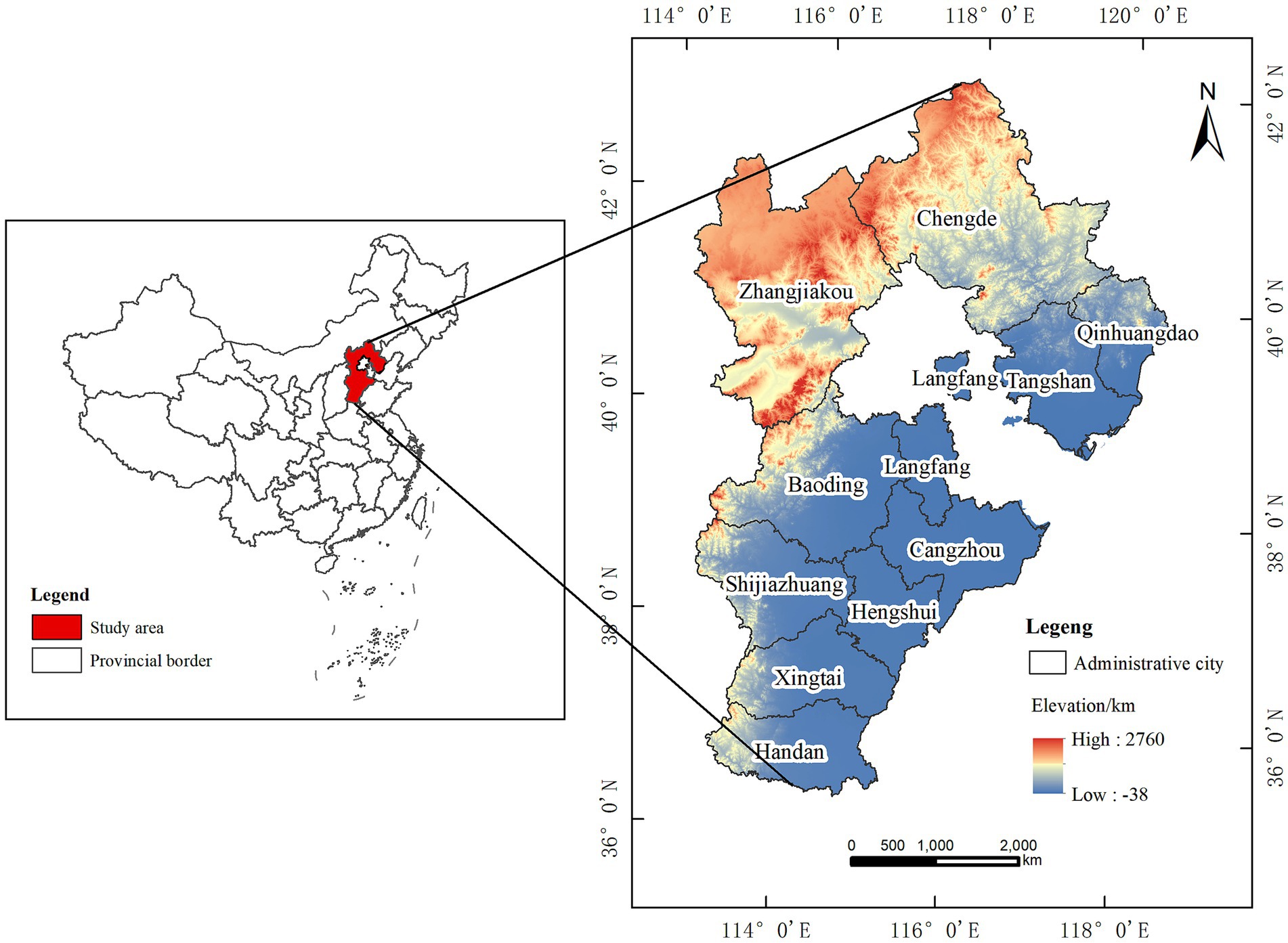
Hebei Province is located in North China, between latitude 36°05′ ~ 42°40′ north and longitude 113°27′ ~ 119°50′ east, with complex and diverse topography, and a complete range of landform types, such as plains, mountains, plateaus, hills, basins, and other landform types, and it is an important ecological barrier for the Beijing-Tianjin area. Hebei Province has a temperate continental monsoonal climate, with an average precipitation of between 300 and 800 mm per year, and an average temperature of between −2°C and 14°C per year. There are obvious geographical differences in land-use types, with cropland widely distributed, mainly focusing on the center and south of the study area, and woodland and grassland mainly in the north of the study area. In 2020, the total water consumption of Hebei Province will be 18.28 billion m3, and the total water resources will be 14.63 billion m3, accounting for 3.14 and 0.46% of the total amount of water used and total water resources of the country, respectively; as one of the main grain-producing provinces, Hebei Province has always ranked at the forefront of grain production in the country, with a total grain output of 38,651,000 ton in 2022, ranking seventh in the country; the total energy consumption of Hebei Province is large, and the energy structure is still dominated by coal, and carbon emissions are at a high level in the country. It is significant for Hebei Province to realize the carbon peak and carbon neutrality for the country as a whole (Figure 1).
2.2 Data sources
Acquisition of land-use data from the Resource and Environmental Sciences Data Center of the Chinese Academy of Sciences (CAS) for three periods, 2010, 2015, and 2020, for use in the study. According to the National 1:100,000 Land Use Classification System of the CAS Resource and Environment Data Center, land use is classified into six first-level land categories: cropland, woodland, grassland, water, building site, and unused land. Precipitation data are derived from the ERA5-Land data set published by the European Union (EU) and organizations such as the European Center for Medium-Range Weather Forecasts (ECMWF). The years of Defense Meteorological Program/Operational Line-Scan System (DMSP/OLS) nighttime lights are 1992–2013, and the years of National Polar-orbiting Partnership (NPP)/Visible Infrared Imaging Radiometer Suite (VIIRS) nighttime lights are 2012–2023. It is not possible to analyze the data of DMSP-OLS and SNPP-VIIRS in direct comparison because of the differences in resolution, product update cycle, and so on. Therefore, the nighttime light data for 2010, 2015, and 2020 are quoted from corrected year-by-year China-wide DMSP-OLS-like data for 1992–2023 obtained by Wu et al. (2021) by integrating DMSP-OLS and SNPP-VIIRS data at a resolution of 1 km in the coordinates WGS_1984_. Albers. Data from the Geographic Data Sharing Infrastructure, global resources data cloud.1 The county data of Hebei province are mainly from the Hebei Statistical Yearbook and Hebei Rural Statistical Yearbook, and the missing data are interpolated by linear interpolation method.
2.3 Analysis of the coupling mechanism of the water–food–carbon–land system
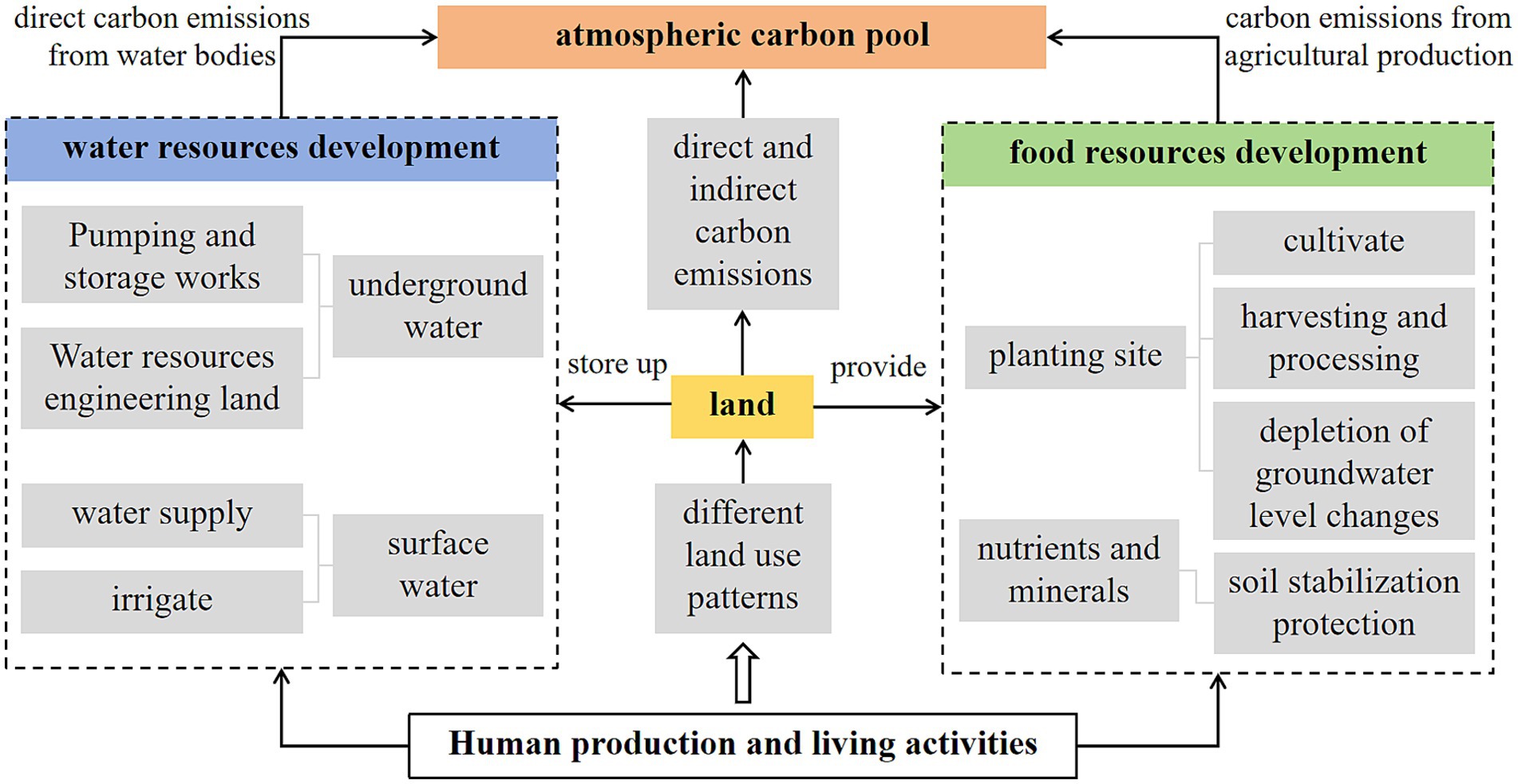
Land is an important basis for carrying water, food, and other resources and their activities smoothly, and it has an important impact on water and food that cannot be ignored; it is also an important carbon reservoir, with large differences in carbon storage and emissions between different land-use patterns. Land, water, food, and carbon interact, exchange and feedback of material and energy between each other, and its mechanism of action is shown in Figure 2. The four elements, water, food, carbon, and land, cover the raw materials, sites, drivers, and impacts of human activities in the region. “Land” is the basis and place for various human activities and the source of nutrients for plant growth; “water” is the substance and medium necessary for life activities and the raw material for most industrial production processes; “food” is the basic material for economic and social development, and the raw material of biomass for energy production; “carbon” is the material basis for major energy sources, as well as the emission and metabolism products of various activities of human beings. The land is the basis for all activities, including carrying resources such as water and food and realizing their use, the development and utilization of which are interlinked. Cultivation, irrigation, production, harvesting, and processing of food continuously consume water, energy, and soil fertility. In contrast, hazardous substances produced during food production lead to the contamination of groundwater resources, as well as chemical fertilizers, pesticides, mulch films, the use of agricultural machinery and equipment, and the use of irrigation equipment, directly and indirectly in agricultural production, generating carbon emissions. Water resources are one of the main bodies constituting the land system, and its transport and purification processes are accompanied by energy consumption. The different types and intensities of energy inputs in different parts of the utilization of land and water resources largely affect the carbon emission intensity of regional human activities. Because different natural and social territories have different WEF mix relationships and carbon footprints. Therefore, the combined configuration of various types of resources in the region needs to be considered comprehensively, especially land resources that play a basic carrier function in the system, and a reasonable land utilization approach can promote the effective configuration and coordinated development of various types of resources.
2.4 Research methodology
2.4.1 Construction of the indicator system
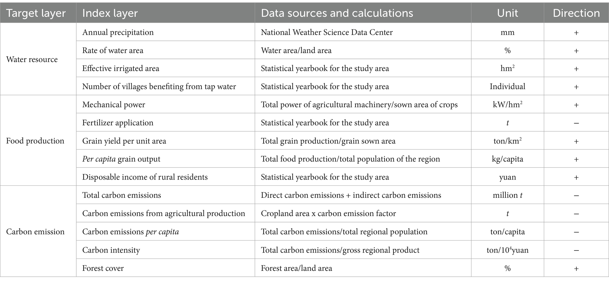
This study considers the dependency relation between the three resources, namely, water, food, and carbon, and combines the existing statistics on the statistical status of county scale data, following the principles of comprehensiveness, systematicness, scientificalness, representativeness, and data availability. Based on these, this study determines a comprehensive evaluation index system of water–food–carbon for the Hebei Province region (Table 1). Fertilizer application, total carbon emissions, carbon emissions from agricultural production, per capita carbon emissions, and carbon intensity are negative indicators, while the others are positive. The carbon emissions research discussed in this article mainly includes direct carbon emissions and indirect carbon emissions in the total amount. Direct carbon emissions from land-use change, including carbon emissions from cropland, forest land, grassland, water, and unused land, are obtained by using the carbon emission coefficient method (Li et al., 2023); In Hebei Province, due to the lack of energy statistics at the city and county scales, indirect carbon emission data within the study area were used to simulate carbon emissions from urban energy consumption by using DMSP/OLS nighttime lighting data and NPP/VIIRS nighttime lighting data (Wu et al., 2022).
2.4.2 Measurement of land-use change
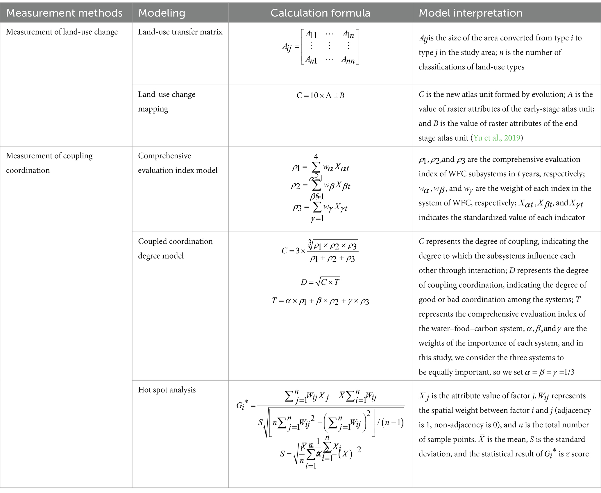
The measurement methods used in this section include land-use transfer matrices and land-use change mapping. Land-use transfer matrices are a classic means to explore the transfer direction and quantity change between land-use types, demonstrating the evolution of land-use type patterns. With the area tabulation function ArcGIS10.7, the cross-tabulated areas of the two-phase land-use raster image datasets can be calculated, and the results can be output. Land-use change mapping is mainly through the spatial superposition of land-use data in different periods to reflect the change of land-use patterns in a certain period. Drawing on the existing mapping fusion method, the mapping fusion is realized by superimposing the codes of the mapping units of the land-use types in the previous periods according to the map algebra to record the evolution process of the mapping units. The formulas and indicators are explained in Table 2.
2.4.3 Measurement of coupling coordination degree
In the constructed integrated evaluation index system of the water–food–carbon system, due to the large differences in the dimensions, orders of magnitude, and positive and negative orientations of each index, it is vital to standardize the original data collected to ensure the scientific validity and rigor of evaluation results. First, the entropy weight method is used to calculate the weights of evaluation indexes, and the comprehensive evaluation indexes of the three systems of water, food, and carbon are finally calculated. Then, this study quantitatively analyses the degree of interaction between the comprehensive evaluation indices of the WFC system in Hebei Province through the coupling degree model. Although the coupling degree model can quantify the degree of dependence between different systems and describe the degree of closeness between systems, the coupling degree alone cannot reflect the level of coordinated development between systems or elements. It is not easy to reflect the overall coordinated development effect of a region, especially in the case of comparative studies of multiple regions. Meanwhile, in multidimensional systems with complex relationships, coupling alone cannot effectively represent the interaction and interdependence between different dimensions. Therefore, the level of coordinated development between WFC systems in different regions is further evaluated by constructing the coupling coordination degree. To better analyze the degree and stage of development of coordination between systems, the degree of coupled coordination is classified into levels and types concerning existing research results (Zhang et al., 2020; Table 3). At last, the hotspot analysis can be used to explore whether spatial changes in the regional water–food–carbon coupling coherence are characterized by the phenomenon of high-value clustering (hotspots) and low-value clustering (coldspots), and to determine where spatial clustering occurs in high and low-value areas. If a range of water–food–carbon system coupling degree of coordination changes compared with the surrounding higher, it turns into a statistically significant hotspot, called the coupling degree of coordination of value-added hot spot, indicating that the coupling degree of coordination in the area of the increased is larger; if a range of water–food–carbon system coupling degree of coordination changes compared with the surrounding lower, then it turns into a statistically significant cold spot, called the coupling degree of coordination loss cold spot area, indicating that the coupling coherence in the area of a larger reduction. The formulas and indicators are explained in Table 3.
2.4.4 Measurement of the impact of land-use change on the degree of coupling coordination
This study contains two aspects: the effect of quantitative and spatial land-use changes on the degree of coordination of the system coupling. First, the Pearson coefficient method was used to reflect the correlation between land-use change and the coupling coordination degree of water–food–carbon system in Hebei Province during 2010–2015 and 2015–2020. Then, using the land-use change map and the hot spot map of the coupling coherence of the water–food–carbon system as the basic data, the influence of land-use change on the coupling coordination degree in spatial dimensions was explored through the superposition of the two.
3 Results
3.1 Analysis of land-use change
3.1.1 Quantitative characteristics of changes in land-use area
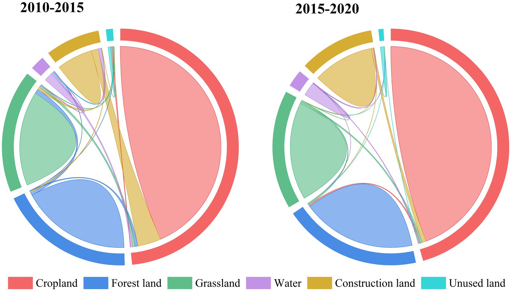
From Table 4, the overall expression of changes in the mutual transfer of the area of each land-use category is the largest transfer in the area of the construction site, the largest transfer out of arable land, and the smallest transfer in the area of unused land. In terms of the area of land transferred in, the amount of construction land transferred in from 2010 to 2020 is 9,711.72 km2, and its primary source is cropland; in terms of the area of land shifted out, the amount of cropland shifted to other land-use types from 2010 to 2020 is 11,387.24 km2. From Figure 3, it can be seen that 2010–2015 was a stronger period of land transfer in Hebei Province, with a total converted area of 40,824.78 km2, of which the cropland area turned out to be the largest, 9,833.49 km2. The largest area transferred to the type is construction land, amounting to 8,881.83 km2, which is mainly converted from grassland and cropland. The next largest area transferred from cropland is 4,353.70 km2, which is mainly converted from construction sites and grassland. The total area of land transformed from 2015 to 2020 is 12,244.56 km2. Among them, the largest area of cropland is transferred in, which is 1,791.71 km2, and the main source of cropland is construction land, but at the same time, the largest area of cropland is transferred out, which is 2,545.30 km2, and it is mainly used as construction land, and the second largest area is grassland, which is transferred out, which is 11,36.32 km2, and it is mainly transformed into cropland.
3.1.2 Characteristics of spatial differentiation in land-use change
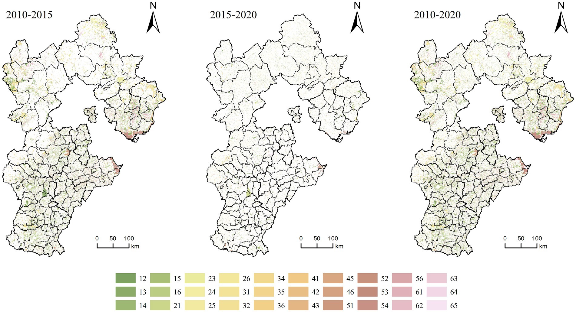
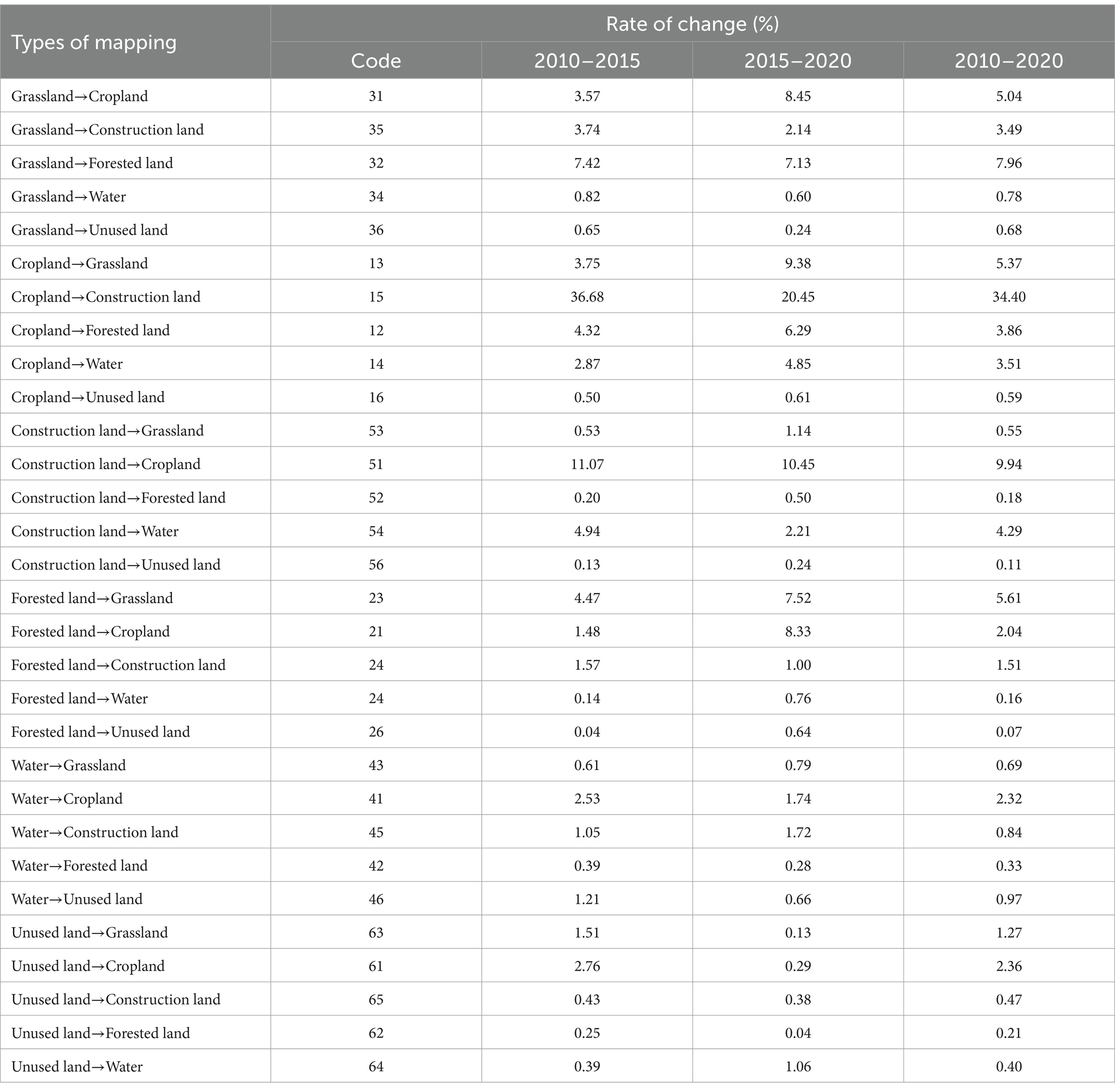
According to formula (2), the calculation results in obtaining the characteristics of the land-use change pattern map of Hebei Province in 2010–2015, 2015–2020, and 2010–2020. As can be seen from Figure 4 and Table 5, in general, the change of land-use categories from 2010 to 2020 is dominated by the conversion of cropland to construction land, building sites to cropland, and grassland to woodlands, with the conversion area of the three beings: 8,207.20, 2,370.39, and 1,898.88 km2, and the rate of change being 34.40, 9.94, and 7.96%, respectively.
In terms of phases, from 2010 to 2015, the mapping unit with the largest variation is the conversion of cropland to the construction site, with a change rate of 36.68% and a changing area of 7,493.97 km2, which is mainly located in Baoding, Xingtai and Shijiazhuang regions; the conversion of construction land to cropland is also stronger, with a change rate of 11.07% and a changing area of 2,262.38 km2, which mainly occurs in the Cangzhou, Baoding and Hengshui areas; next is the conversion of grassland to forest land, with a change rate of 7.42% and a changing area of 1,515.35 km2, mainly in Zhangjiakou, Chengde, and Qinhuangdao areas. From 2015 to 2020, the change rate of cropland converted to construction land was 20.45%, which was 16.23% lower than that of the previous period, indicating that the expansion of building sites in this period was significantly reduced, and the area converted was 1,252.24 km2; at the same time, the conversion of the building site to arable land was also stronger, with a change rate of 10.45% and an area of 640.03 km2, which was mainly concentrated in the Baoding, Handan, and Xingtai areas; the change rate of cropland to grassland was also larger, at 9.38%, with a changing area of 574.23 km2, concentrated in Zhangjiakou and Chengde areas.
3.2 Analysis of the coupled coherence of the WFC system
3.2.1 Analysis of the degree of subsystem coupling and coupling coordination
The coupling coordination of the WFC system and its subsystems in Hebei Province in 2010, 2015, and 2020 were calculated by coupling coordination degree mode.
From Figure 5A, the overall coupling degree of the system slightly swings in the range of 0.75 ~ 0.85, maintaining a high coupling status for a long time, reflecting a strong correlation among the systems. The degree of coupling coordination fluctuates greatly and demonstrates a rising and subsequently falling trend between 2010 and 2020, and the overall performance between water, food, and carbon in Hebei Province needs to be more coordinated development level. The two subsystems have also maintained high coupling for a long time, of which the water–food system has the highest and most stable coupling, which has a pulling effect on improving the overall level of coupling and coordination, and the food–carbon system has a relatively weak degree of coupling. Figure 5B shows that the water–food system has the highest level of coupled coordination, with relatively large changes, moving from moderate coordination to barely coordinated during the 2010–2020 period, which has a higher impact on the overall level of coupled coordination of the system. The water-carbon system fluctuates slightly in the range of 0.35–0.40 and shows an overall mild level of misalignment.
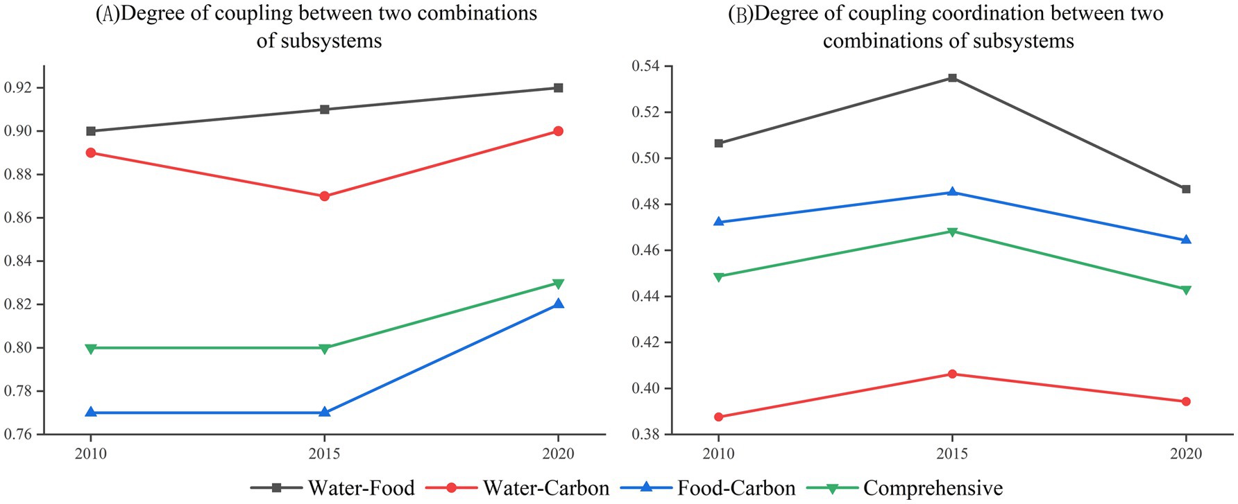
Figure 5. Degree of coupling and coupling coordination for two-by-two combinations of subsystems (A) Degree of coupling between two combinations of subsystems (B) Degree of coupling coordination between two combinations of subsystems.
3.2.2 Characteristics of the spatial distribution of the overall coupling coordination degree of the system
The coupling degree and coupling coordination degree of the WFC system in each county of the study area from 2010 to 2020 were calculated, and according to the change of coupling coordination type and its numerical evolution characteristics in each region, the spatial evolution map of coupling coordination of WFC system in study area at each time node was plotted.
From Figure 6, it can be seen that from 2010 to 2020, high-level coordination areas were dominated by the northeastern part of Hebei Province, showing a certain degree of spatial aggregation. From 2010 to 2020, the coupling coordination status has always maintained a medium level of coordination of a total of 26 areas, and is located in the northeastern part of Hebei Province, Chengde City, and eight districts are ranked among them, accounting for 31%, in addition to the northeastern part of the region, the development of the central and western regions is also relatively stable, the level of coupling coordination for an extended period to maintain a relatively high and spatial distribution of the concentration of the situation. The low-level coordination areas have long been laid out within the southwestern part of Hebei Province, showing a certain degree of low-value locking phenomenon. In terms of type change, the number of districts where the coupled coordination status always remains mild disorder from 2010 to 2020 is 11, and the five districts that always remain mildly dysfunctional among all districts and counties in the study area belong to Xingtai City, which are Ren, Nanhe, Julu, Pingxiang, and Guangzong counties, respectively. As a whole, the coupling degree of the WFC system in the study area during 2010–2020 appears to have a spatial pattern of “high in the northeast and low in the southwest.” In general, this feature also has strong stability, but comparing 2010–2015 and 2015–2020, it reveals that although the coupling coordination of the northern region of Zhangjiakou and the western region of Xingtai has increased, the areas with mild dislocations in the central-eastern part of study area show a tendency of shrinking and then expanding.
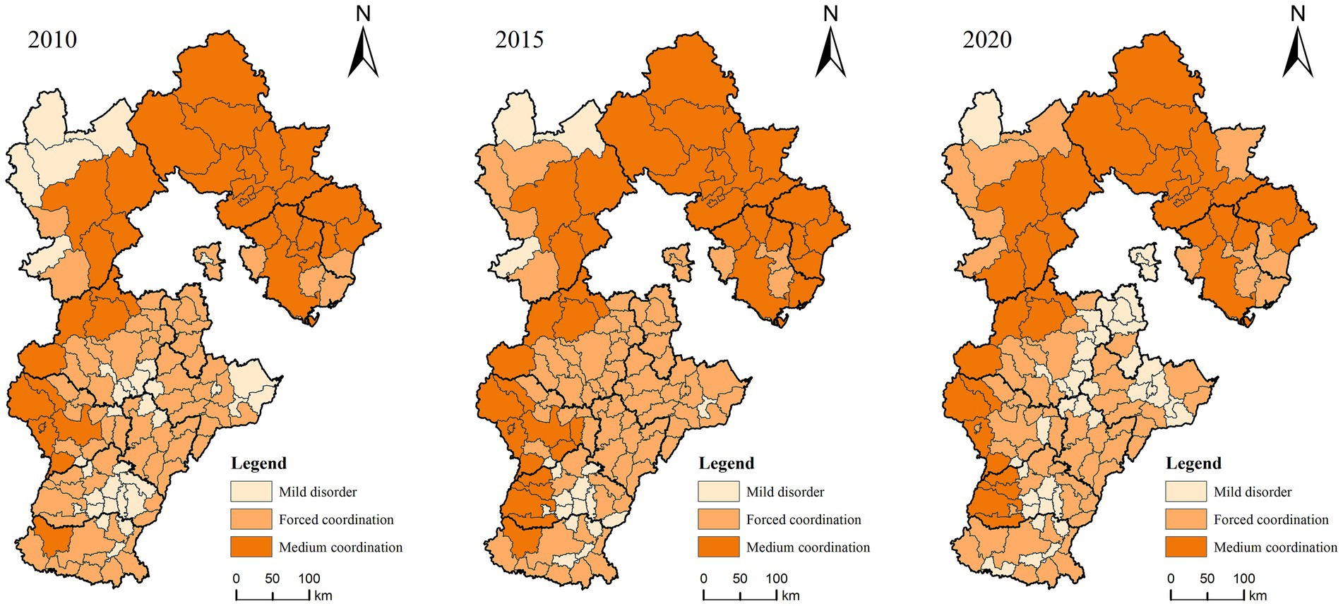
Figure 6. Spatial evolution of the type of coupled coordination degree of the water–food–carbon system in Hebei province.
3.2.3 Characteristics of the spatial evolution of the overall hot and cold spot pattern of the system
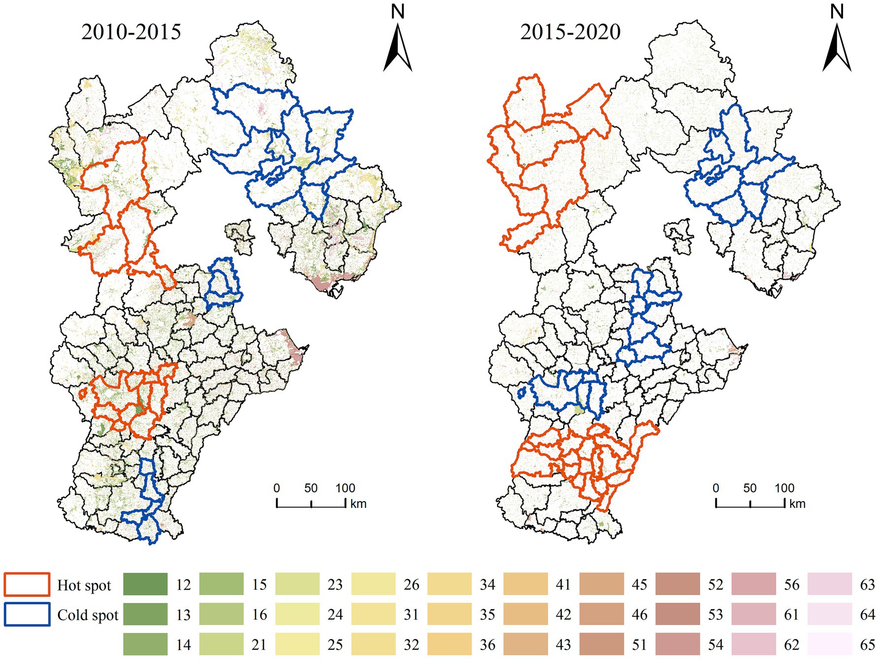
To analyze the spatial distribution of the variation in the coupled coordination degree of the WFC system in Hebei Province, this study employs county areas as the unit of analysis and utilizes hotspot analysis in ArcGIS as the methodological tool. The observed values are derived from the changes in the coupled coordination degree from 2010 to 2015 and from 2015 to 2020. Consequently, hotspot maps depicting the changes in the coupled coordination degree for Hebei Province during the periods of 2010–2015 and 2015–2020 are generated (Figure 7).

Figure 7. Distribution of cold hotspots for changes in the coordination degree of the coupled water–food–carbon system in Hebei Province, 2010–2020.
As illustrated in Figure 7, the cold and hot spots of the coupling coordination degree of the WFC system in Hebei Province were dispersed during the period from 2010 to 2015. Specifically, the hot spots of value-added were predominantly located in the south-central region of Zhangjiakou and the east-central area of Shijiazhuang. In contrast, the cold spots of loss were concentrated in Chengde, with additional scattered occurrences in Xingtai, Handan, Langfang, and Tangshan; From 2015 to 2020, the concentration range of cold and hot spots about the coupling coordination degree of the WFC system in Hebei Province increased. During this period, the value-added hot spots were primarily located in Zhangjiakou and Xingtai, while the cold spots of loss were mainly found in Langfang, Cangzhou, Shijiazhuang, and Chengde. A comparison of the periods 2010–2015 and 2015–2020 reveals an expanding trend in the range of cold and hot spots related to the coupling coordination degree of the WFC system in Hebei Province. Furthermore, there is a notable correlation in the spatial transformation of these cold hot spots. Specifically, areas including the eastern part of Shijiazhuang, Julu County in Xingtai, Pingxiang County, Quzhou County, and Guantao County in Handan transitioned from being cold spots of loss in 2010–2015 to becoming hot spots of value-added in 2015–2020. As a whole, the distribution range of value-added hotspots and loss cold spots in the water–food–carbon system coupling coordination degree in Hebei Province from 2010 to 2020 is large, and the distribution of hotspots has obvious spatial agglomeration, which is characteristic of the overall performance of the “large difference between the high and low values of east–west agglomeration, and distribution of hot spots in both north and south”.
3.3 Impact of land-use change on the coordination of coupled WFC systems
3.3.1 Impact of changes in land-use quantities on the degree of coupling coordination
To study the impact of land-use changes on the coupling coordination of the WFC system in Hebei Province, correlation analyses were carried out between the two based on the Pearson correlation coefficient (Figure 8).
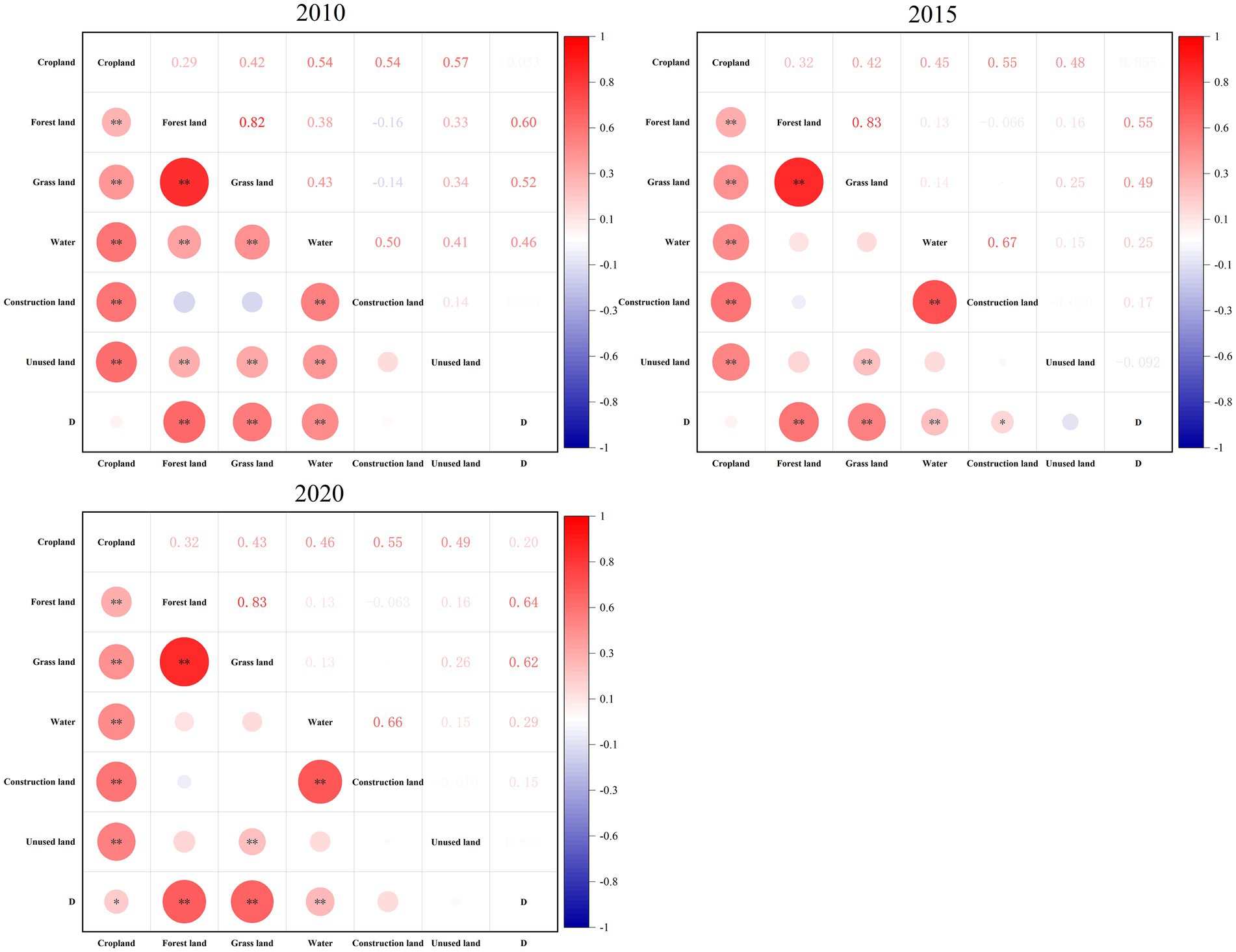
Figure 8. Correlation coefficients between land-use types and the degree of coordination of the coupled water–food–carbon system.
By stages, in 2010, the WFC system in the study area was significantly positively correlated with forest land, grassland, and waters, with correlation coefficients of 0.60, 0.52, and 0.46, respectively; in 2015, the WFC system in Hebei Province was significantly positively correlated with woodland, grassland, waters and construction site, with the correlation coefficient of construction land is relatively low, at 0.17; in 2020, the degree of coordination of the WFC system in Hebei Province is significantly positively correlated with cropland, woodland, grassland and water, of which the correlation with cultivated land has changed from irrelevant to relevant, with a correlation coefficient of 0.20. Overall, the WFC system in the study area during the study period had a stable positive correlation with forest land, grassland, and watersheds, but the correlation between the degree of coordination of the system coupling, and woodland and grassland, increased, and the correlation with water showed a decreasing trend. Therefore, the increase in the area of woodland and grassland can ensure regional water resources, food security, and green ecological development through water conservation, emission reduction and sink enhancement, and soil and water conservation, thus increasing the benign reciprocal feedback among the systems and facilitating the enhancement of the coupling coherence.
3.3.2 Impact of spatial land-use change on the degree of coupling coordination
The land-use change map was superimposed with the hot spot map of the change in the WFC system (hotspots and cold spots with statistical significance with a confidence level of 95% and above were selected) to analyze the land-use change in the cold hot spot regions in Hebei Province in the 2010–2015 and 2015–2020 periods.
Figure 9 shows that during the period 2010–2015, the value-added hotspot areas are distributed in the south-central region of Zhangjiakou and the east-central region of Shijiazhuang, and their increase is mainly attributed to the conversion of cropland to construction land, woodland, and grassland, in which the area of cropland converted to building site is the largest, with the converted area of 1,009.19 km2, followed by cropland converted to forest land and grassland, with the converted areas of 290.89 and 148.30 km2. The loss of cold spot area is mainly concentrated in Chengde, Langfang, and Handan areas, and its decrease mainly comes from the conversion of cropland to building land, with a conversion area of 733.34 km2; next, the biological space of grasslands and forests is converted to various types of land., with a conversion area of 542.74 and 330.47 km2; during the period 2015–2020, the value-added hotspot areas are mainly distributed in Zhangjiakou and Xingtai regions, and their increase mainly originates from the conversion of cropland, with a conversion area of 488.00 km2, of which the area of cropland converted to the building site is the largest, with a conversion area of 201.05 km2. The loss of cold spot areas is mainly concentrated in Shijiazhuang, Tangshan, and Chengde regions, and its reduction mainly originates from the conversion of woodland to arable land and woodland to grassland, with the conversion areas of 129.20 and 85.53 km2, respectively.
4 Discussion and recommendations
4.1 Changes in the coupling coordination degree of water–food–carbon system
The coupled coordination degree model indicates that the overall coupled coordination level of Hebei Province in 2010–2020 shows a barely coordinated development level, which is the same as the research results of Li and Zhang (2020). Hebei Province, China’s major energy consumption province, has huge carbon emissions, and there is a considerable conflict between economic development and resource and ecological protection, which seriously affects the stable and coordinated development of the WFC system. Among them, the fluctuation of the coupling coordination of the water–food system is more obvious; Hebei Province, as a main agricultural region, the contradiction between water resources and grain is more prominent, agriculture accounts for more than 60% of the total water consumption, the water-grain system is closely related (He and Yuan, 2021). Compared with provincial-scale resource studies (Wang and Tian, 2022), county-scale studies can more accurately identify the development level of the WFC system in each region. From the viewpoint of spatial distribution, the city of Chengde, which has a high coupling coherence, resides in the northeast region of the study area; however, for the period 2010–2020, the coupling coordination in the northern part of Zhangjiakou increased, and at the same time the hotspot value-added areas are also distributed more agglomerated in Zhangjiakou. Zhangjiakou has a larger area of agricultural land, more developed agriculture, better ecological advantages, slower urban expansion than other regions, and abundant water resources.
4.2 Impact of changes in land-use quantities on the degree of coupling coordination
While studying, the building site of Hebei Province has been expanding and ecological and agricultural land has been shrinking, which in turn affects the coupling coherence of the regional WFC system. Among them, cropland area and the level of regional WFC system coupling coordination are positively connected, and the conversion of cropland to the building site is the most dominant type of land-use change during the study period. Cropland has the ecological functions of producing organic matter, gas regulation, water containment, soil retention, environmental purification, and other ecological functions, it is an important ecological landscape and the most important production resource for human survival (Ren et al., 2016), however, the area of cropland in Hebei Province has been declining year by year, thus threatening the development of the coupling coherence of the WFC system; the area of woodland, grassland, and watershed is positively correlated with the degree of coordination of regional WFC system coupling, from the point of view of the hotspot value-added areas in Hebei Province, from 2010 to 2020, the main reason for the increase in the degree of coupling coordination due to land-use change is the conversion of other types of land to woodland or grassland., and the increase in the area of woodland and watershed not only eases the demand for water resources in Hebei Province’s agricultural production but also helps to Biodiversity restoration, which in turn inhibits the living space of agricultural pests, ensuring stable food production (Dainese et al., 2019); generally speaking, the increase of construction land will squeeze the space for food cultivation and contribute to higher pollutant emissions, which will have a negative impact on coordinated development. However, in this study, the building site is not relevant to it, which may be related to the relatively low level of economic development of the study area, which indicates that the increase of the building site is at a reasonable stage of the urbanization process in Hebei Province, and will not negatively affect the coupling coordination for the time being.
4.3 Impact of spatial land-use change on the degree of coupling coordination
Analyses from a spatial perspective can be targeted to spatially regulate land-use and improve the coupling coherence of regional WFC systems according to local conditions. In terms of phasing, the value-added hotspots in 2010–2015 were distributed in the south-central region of Zhangjiakou, and the east-central region of Shijiazhuang, with the south-central region of Zhangjiakou, mainly attributed to the transformation of other spaces into grassland ecological space, and the east-central region of Shijiazhuang due to the transformation of other spaces into forest land ecological space, and the loss of the cold spot area was more clustered in scope in this period, especially in the northeastern region of study area. This is primarily because of the transformation of forest land and grassland ecological space in this region. In 2015–2020, there is a tendency to expand the scope of loss cold spot zones, so for value-added hot spot zones, based on improving the level of intensive and economical use of land, it is necessary to guide the WFC system to a higher level, and in the case of loss of cold spots, the protection of ecological resources in parts of these counties should be strengthened, and to rationally plan the land resources of cropland, forest land and waters, to promote sustainable development of the resources.
Land has a special role in water resources, food resources, and carbon emissions, and promoting the rational use of land resources is an effective way to improve the WFC system in the region. The specific recommendations are as follows:
(1) Optimize the layout and structure and strictly abide by the red line of cropland. Hebei Province is one of the significant agricultural provinces in China. Nevertheless, due to the development of new urbanization, the area of cropland is decreasing, so we must adopt strict cultivated land protection policies, reasonably increase ecological land based on ensuring food production security, and coordinate the protection of forests, grasslands, and wetlands.
(2) Seize regional advantages and promote coordinated development. Improving and upgrading the intercoordination between the water–food–carbon systems in Hebei Province, taking advantage of Hebei’s geographical advantages, raising the proportion of clean energy used, developing green low-carbon industries, and grasping energy-saving and carbon-reducing renovation. Hebei is the Beijing–Tianjin–Hebei resilience shortboard, but it is also where the development potential lies, narrowing the gap between Hebei and Beijing–Tianjin will help to realize the Beijing–Tianjin–Hebei synergistic development.
(3) Developing differentiated policies to improve land-use efficiency. For areas with scarce land resources, the use of clean energy should be encouraged, technological innovation should be carried out in industries with high water and energy consumption, drought-tolerant and high-yield crops should be introduced, and the consumption of water, land, and other resources should be reduced. For regions with abundant land resources, the advantages of regional resources should be fully utilized, accelerate the upgrading of their industrial structure, introduce advanced technologies and enhance the overall competitiveness of their economic development.
Compared with most of the current studies on the water-energy-food system, this study incorporates land-use into the system, explores its impact on the degree of coordination of WFC coupling, and then looks for paths to promote the synergistic development of various types of resources. Nevertheless, there are some shortcomings, in the construction of the water–food–carbon system evaluation index system, this study to the county as a research unit, Hebei Province, due to the lack of municipal and county scale part of the index data because there are some limitations in the selection of indicators; this study to the 132 counties in Hebei Province as the object of the study, to explore spatial and temporal variations in the coupled coherence of the water–food–carbon system in 132 districts of the region, the future will be from a multiscale perspective.
5 Conclusion
In this study, by analyzing the changes in land-use types, constructing the evaluation index system for the coupling coordination development of the WFC system, calculating the degree of coupled coordination in Hebei Province from 2010 to 2020, and analyzing the impact of quantitative and spatial land-use changes on the WFC systems, the following conclusions were reached:
(1) From 2010 to 2020, the change of land-use type is characterized by the decrease of cropland and the expansion of building site, with the conversion of cropland to building site dominating in each mapping unit, with a conversion area of 8,207.20 km2, a change rate of 34.40%, and spatially concentrated in Baoding, Xingtai and Shijiazhuang; followed by the conversion of building site to arable land, with a conversion area of 2,370.39 km2 with a change rate of 9.94%, mainly in Cangzhou, Baoding and Hengshui regions.
(2) From a temporal perspective, the coupling degree of the WFC system in the study area from 2010 to 2020 is at a high level, with the system as a whole fluctuating slightly in the range of 0.75 to 0.85, but the coupling degree of coordination of the WFC system is at a low level, fluctuating slightly in the range of 0.35 to 0.40, and the overall performance is at the level of a mild dysfunctional disorder. From a spatial perspective, the water–food–carbon system coupling coordination degree has a significant spatial differentiation law, presenting a spatial distribution pattern of “high in the northeast and low in the southwest”; from 2010 to 2020, the distribution of hot and cold spots in the coupling coherence of the WCF system in study area shows the “east–west high and low values of the agglomeration difference is too large.”
(3) From the point of view of changes in land-use quantity, the coupling coherence of the WFC system in each county from 2010 to 2020 is positively correlated with cropland, forest land, grassland, watersheds, and building sites, and is not correlated with the unused land; regarding the spatial changes in land use, the conversion of urban and rural construction land, as well as agricultural production space, to forest ecological space in the region is primarily responsible for the hotspot value-added areas, while the conversion of forest and grassland ecological space to other land types is the primary cause of the loss of cold spot areas.
Data availability statement
The original contributions presented in the study are included in the article/supplementary material, further inquiries can be directed to the corresponding author/s.
Author contributions
LZhao: Supervision, Writing – review & editing. JY: Conceptualization, Data curation, Methodology, Visualization, Writing – original draft. XS: Writing – original draft. YN: Writing – original draft. JX: Writing – original draft. LZhan: Writing – original draft. XL: Writing – original draft.
Funding
The author(s) declare that financial support was received for the research, authorship, and/or publication of this article. This study was funded by Hebei Social Science Foundation Project (HB23GL014).
Acknowledgments
The authors would like to thank their reviewers for their constructive comments that improved this research.
Conflict of interest
The authors declare that the research was conducted in the absence of any commercial or financial relationships that could be construed as a potential conflict of interest.
Publisher’s note
All claims expressed in this article are solely those of the authors and do not necessarily represent those of their affiliated organizations, or those of the publisher, the editors and the reviewers. Any product that may be evaluated in this article, or claim that may be made by its manufacturer, is not guaranteed or endorsed by the publisher.
Footnotes
References
Bach, H., Jin, R. F., and Sun, Y. (2016). Cooperation on water, energy and food security in transboundary basins in the context of global climate change. Express Water Resour. Hydropower 37, 1–7. doi: 10.15974/j.cnki.slsdkb.2016.08.001
Bai, J. F., and Zhang, H. J. (2018). Spatio-temporal variation and driving force of water-energy-food pressure in China. Sci. Geogr. Sin. 38, 1653–1660. doi: 10.13249/j.cnki.sgs.2018.10.009
Bakhshianlamouki, E., Masia, S., Karimi, P., van der Zaag, P., and Sušnik, J. (2020). A system dynamics model to quantify the impacts of restoration measures on the water-energy-food nexus in the Urmia lake basin, Iran. Sci. Total Environ. 708:134874. doi: 10.1016/j.scitotenv.2019.134874
Beekma, J., Bird, J., Mersha, A. N., Reinhard, S., Prathapar, S. A., Rasul, G., et al. (2021). Enabling policy environment for water, food and energy security. Irrig. Drain. 70, 392–409. doi: 10.1002/ird.2560
Cao, X., Shu, R., Ren, J., Wu, M., Huang, X., and Guo, X. (2020). Variation and driving mechanism analysis of water footprint efficiency in crop cultivation in China. Sci. Total Environ. 725:138537. doi: 10.1016/j.scitotenv.2020.138537
Chen, J. F., and Yan, X. Y. (2020). Coordinated suitability of water-energy-food system and agricultural output on agricultural areas in China: an empirical research based on the threshold effect of human capital. Sci. Technol. Manag. Res. 40, 215–223.
Chen, H., Zhou, S. S., and Han, Z. Y. (2023). The spatial heterogeneity and the influencing factors of “water-soil-energy-grain-carbon” suitability. Ecol. Econ. 39, 115–122.
Conway, D., Van Garderen, E. A., Deryng, D., Dorling, S., Krueger, T., Landman, W., et al. (2015). Climate and southern Africa’s water-energy-food nexus. Nat. Clim. Chang. 5, 837–846. doi: 10.1038/nclimate2735
Dainese, M., Martin, E. A., Aizen, M. A., Albrecht, M., Bartomeus, I., Bommarco, R., et al. (2019). A global synthesis reveals biodiversity-mediated benefits for crop production. Sci. Adv. 5:eaax0121. doi: 10.1126/sciadv.aax0121
Dang, R., Zhang, J., Zhou, D. M., Liu, Y., Ma, J. J., Zhu, X. Y., et al. (2020). Characteristic of the coupling and coordination of water-energy-food of Gansu Province during 2000-2016. J. Water Resour. Water Eng. 31, 115–123.
Deng, C., Wang, H., Gong, S., Zhang, J., Yang, B., and Zhao, Z. (2020). Effects of urbanization on food-energy-water systems in mega-urban regions: a case study of the Bohai MUR, China. Environ. Res. Lett. 15:44014. doi: 10.1088/1748-9326/ab6fbb
Ding, T., Fang, L., Chen, J., Ji, J., and Fang, Z. (2023). Exploring the relationship between water-energy-food nexus sustainability and multiple ecosystem services at the urban agglomeration scale. Sustain. Prod. Consum. 35, 184–200. doi: 10.1016/j.spc.2022.10.028
Endo, A., Tsurita, I., Burnett, K., Orencio, P. M., et al. (2017). A review of the current state of research on the water, energy, and food nexus. J. Hydrol., 11: 20–30. doi: 10.1016/j.ejrh.2015.11.010
Gai, M., and Zhai, Y. X. (2021). Measurement and coordinated development of water resources, energy, food and support security in China. Acta Ecol. Sin. 41, 4746–4756. doi: 10.5846/stxb202001180147
Han, D., Yu, D., and Cao, Q. (2020). Assessment on the features of coupling interaction of the food-energy-water nexus in China. J. Clean. Prod. 249:119379. doi: 10.1016/j.jclepro.2019.119379
He, H. S., and Yuan, L. L. (2021). Analysis and prediction of water-energy-food coupling and coordinated development in the main grain-producing areas in China. Ecol. Econ. 37, 102–108.
Ibrahim, M. D., Fereira, D. C., Daneshvar, S., and Marques, R. C. (2019). Transnational resource generativity: eficiency analysis and target setting of water, energy, land, and food nexus for OECD countries. Sci. Total Environ. 697:134017. doi: 10.1016/j.scitotenv.2019.134017
Jiang, W. Y., Zeng, Z. X., and Zhang, Z. Y. (2020). China’s industrial and agricultural carbon emission efficiency and reduction potential considering the water-land-energy-carbon nexus. Chin. J. Environ. Manag. 12, 120–129. doi: 10.16868/j.cnki.1674-6252.2020.06.120
Jin, T. (2019). The adjustment of China’s grain cropping structure and its effect on the consumption of water and land resources. J. Nat. Resour. 34, 14–25. doi: 10.31497/zrzyxb.20190102
Kaddoura, S., and El Khatib, S. (2017). Review of water-energy-food Nexus tools to improve the Nexus modelling approach for integrated policy making. Environ Sci Policy 77, 114–121. doi: 10.1016/j.envsci.2017.07.007
Khan, H. F., Yang, Y. C., Xie, H., and Ringler, C. (2017). A coupled modeling framework for sustainable watershed management in transboundary river basins. Hydrol. Earth Syst. Sci. 21, 6275–6288. doi: 10.5194/hess-21-6275-2017
Lee, S. H., Taniguchi, M., Mohtar, R. H., Choi, J. Y., and Yoo, S. H. (2018). An analysis of the water-energy-food-land requirements and CO2 emissions for food security of rice in Japan. Sustain. For. 10:3354. doi: 10.3390/su10093354
Li, L., Bi, J., Zhou, Y. C., and Liu, M. M. (2018). Research progress of regional environmental risk management: from the perspectives of food-energy-water nexus. China Popul. Resour. Environ. 28, 85–92. doi: 10.12062/cpre.20180203
Li, G. J., Huang, D. H., and Li, Y. L. (2017). Evaluation on the efficiency of the input and output of water-energy-food in different regions of China. Comp. Econ. Soc. Syst. 3, 138–148.
Li, G. J., Li, Y. L., Jia, X. J., Du, L., and Huang, D. H. (2016). Establishment and simulation study of system dynamic model on sustainable development of water-energy-food nexus in Beijing. Manag. Rev. 28, 11–26. doi: 10.14120/j.cnki.cn11-5057/f.2016.10.002
Li, Y. L., Wang, J. L., and Yang, L. (2022). Study on temporal and characterisation of agricultural carbon emissions in Hunan Province at county scale. Chin. J. Agric. Resour. Reg. Plann. 43, 75–84. doi: 10.7621/cjarrp.1005-9121.20220409
Li, Y. Y., Wei, W., Zhou, J. J., Hao, R. J., and Chen, D. B. (2023). Changes in land use carbon emissions and coordinated zoning in China. Environ. Sci. 44, 1267–1276. doi: 10.13227/j.hjkx.202204009
Li, C. Y., and Zhang, S. Q. (2020). Chinese provincial water-energy-food coupling coordination degree and influencing factors research. China Popul. Resour. Environ. 30, 120–128.
Liu, S., and Zhao, L. (2022). Development and synergetic evolution of the water-energy-food nexus system in the Yellow River Basin. Environ. Sci. Pollut. Res. 29, 65549–65564. doi: 10.1007/s11356-022-20405-9
Mahjabin, T., Mejia, A., Blumsack, S., and Grady, C. (2020). Integrating embedded resources and network analysis to understand food-energy-water nexus in the US. Sci. Total Environ. 709:136153. doi: 10.1016/j.scitotenv.2019.136153
Momblanch, A., Papadimitriou, L., Jain, S. K., Kulkarni, A., Ojha, C. S., Adeloye, A. J., et al. (2019). Untangling the water-food-energy-environment nexus for global change adaptation in a complex Himalayan water resource system. Sci. Total Environ. 655, 35–47. doi: 10.1016/j.scitotenv.2018.11.045
Peng, S. M., Zheng, X. K., Wang, Y., and Jiang, G. Q. (2017). Study on water-energy-food collaborative optimization for Yellow River basin. Adv. Water Sci. 28, 681–690. doi: 10.14042/j.cnki.32.1309.2017.05.005
Qin, T., and Tong, J. P. (2021). Spatiotemporal change of water-energy- food coupling efficiency and influencing factors in the Yangtze River Economic Belt. Resour. Sci. 43, 2068–2080. doi: 10.18402/resci.2021.10.11
Ren, P., Hong, B. T., Ma, W. L., Yuan, Q. Z., and Zhou, J. M. (2016). Ecological value estimation of cultivated land based on the IBIS model: a case study of Chongzhou city. Geogr. Res. 35, 2395–2406. doi: 10.11821/dlyj201612017
Sun, C. Z., and Yan, X. D. (2018). Security evaluation and spatial correlation pattern analysis of water resources-energy-food nexus coupling system in China. Water Resour. Prot. 34, 1–8.
Sun, C., Yan, X., and Zhao, L. (2021). Coupling efficiency measurement and spatial correlation characteristic of water-energy-food nexus in China. Resour. Conserv. Recycl. 164:105151. doi: 10.1016/j.resconrec.2020.105151
Wang, H. M., Hong, J., and Liu, G. (2019). Simulation research on different policies of regional green development under the nexus of water-energy-food. China Popul. Resour. Environ. 29, 74–84. doi: 10.12062/cpre.20190125
Wang, L. C., Hou, B. D., Zhou, Y. Y., Chen, X. Q., Wang, X., and Huang, Y. (2021). Research on the coupling coordinative degree in urban water-energy-food system. Hydro Sci. Eng. 1, 9–17. doi: 10.12170/20200217001
Wang, L. Q., Jiang, S., Liu, H. W., Li, W., Cheng, J. H., and He, F. (2024). Evaluation of coupling and coordinated development characteristics of water-energy-food system security in Beijing-Tianjin-Hebei region. S. N. Water Sci. Technol. 22, 12–23. doi: 10.13476/j.cnki.nsbdqk.2024.0002
Wang, Q., Li, S., He, G., Li, R., and Wang, X. (2018). Evaluating sustainability of water-energy-food (WEF) nexus using an improved matter-element extension model: a case study of China. J. Clean. Prod. 202, 1097–1106. doi: 10.1016/j.jclepro.2018.08.213
Wang, K., Li, J. B., and Li, H. (2020). Spatial and temporal variation characteristics of the coupling and coordination of water-energy-food nexus in Shanxi Province. Journal of water resources and water. Engineering 31, 45–52+58. doi: 10.11705/j.issn.1672-643X.2020.03.07
Wang, Y., and Sun, R. X. (2022). Impact of land use change on coupling coordination degree of regional water-energy-food system: a case study of Beijing-Tianjin-Hebei urban agglomeration. J. Nat. Resour. 37, 582–599. doi: 10.31497/zrzyxb.20220303
Wang, Z. H., and Tian, Y. W. (2022). Water-energy-food nexus and its influencing factors in China. South-to-north water transfers and water resources. Sci. Technol. 20, 243–252. doi: 10.13476/j.cnki.nsbdqk.2022.0026
Wang, J., and Ye, N. J. (2022). Dynamic evolution and spatial characteristics analysis of water-energy-food system coupling and coordination: a case study of Hebei Province. China Rural Water Hydropower 12, 66–71. doi: 10.12396/znsd.220269
Wicaksono, A., and Kang, D. (2019). Nationwide simulation of water, energy, and food nexus: case study in South Korea and Indonesia. J. Hydro Environ. Res. 22, 70–87. doi: 10.1016/j.jher.2018.10.003
Wu, Y. Z., Shi, K. F., Chen, Z. Q., Liu, S. R., and Chang, Z. J. (2021). Developing improved time-series DMSP-OLS-like data (1992–2019) in China by integrating DMSP-OLS and SNPP-VIIRS. IEEE Trans. Geosci. Remote Sens. 60, 1–14. doi: 10.1109/TGRS.2021.3135333
Wu, A. B., Zhao, Y. X., Guo, X. P., and Fan, B. (2022). Spatio-temporal differentiation of carbon emissions in the Beijing-Tianjin-Hebei region based on land use and nighttime light data. Geogr. Geoinf. Sci. 38, 36–42. doi: 10.3969/j.issn.1672-0504.2022.06.006
Yu, C., Hu, D. Y., Cao, S. S., Zhang, Y., Zhang, Y. N., and Duan, X. (2019). The spatial characteristics and changes of ISP-LST of Beijing in recent 30 years. Geogr. Res. 38, 2346–2356.
Zhan, Y. C., Wu, L., and Wang, Y. X. (2014). Conflicts between China and the United States over water, energy and food. China Econ. Rep. 1, 109–111.
Zhang, H. P., He, R. W., Li, G. Q., and Wang, J. (2020). Spatiotemporal evolution of coupling coordination degree of urban-rural integration system in metropolitan area and its influencing factors: taking the capital region as an example. Econ. Geogr. 40, 56–67. doi: 10.15957/j.cnki.jjdl.2020.11.007
Zhang, N., Yang, X., and Chen, T. (2022). Spatial and temporal characteristics of coupled water-energy-food system coordination in western China. China Environ. Sci. 42, 4444–4456. doi: 10.19674/j.cnki.issn1000-6923.20220609.001
Zhao, L. S., Liu, S. J., and Sun, C. Z. (2021). Study on coupling and coordinated development of water-energy-food security system in the Yellow River Basin. Water Resour. Prot. 37, 69–78. doi: 10.3880/j.issn.1004-6933.2021.01.010
Keywords: land use change, water-food-carbon system, coupling coordination, hotspot analysis, correlation analysis
Citation: Zhao L, Yu J, Song X, Niu Y, Xie J, Zhang L and Li X (2024) Impact of land-use change on coupling coordination degree of regional water–food–carbon system. Front. Sustain. Food Syst. 8:1449041. doi: 10.3389/fsufs.2024.1449041
Edited by:
Xueru Zhang, Hebei University of Economics and Business, ChinaReviewed by:
Li Cuizhen, Zhejiang Gongshang University, ChinaJingxin Li, National Disaster Reduction Center of China, China
Copyright © 2024 Zhao, Yu, Song, Niu, Xie, Zhang and Li. This is an open-access article distributed under the terms of the Creative Commons Attribution License (CC BY). The use, distribution or reproduction in other forums is permitted, provided the original author(s) and the copyright owner(s) are credited and that the original publication in this journal is cited, in accordance with accepted academic practice. No use, distribution or reproduction is permitted which does not comply with these terms.
*Correspondence: Li Zhao, emhhb2xpQGhlYmF1LmVkdS5jbg==
 Li Zhao
 Jie Yu
 Xinming Song4
 Xiaoqing Li