- 1Water and Land Resource Centre, Addis Ababa, Ethiopia
- 2School of Earth Sciences, College of Natural and Computational Sciences, Addis Ababa University, Addis Ababa, Ethiopia
- 3College of Development Studies, Addis Ababa University, Addis Ababa, Ethiopia
- 4Debre Birhan University, Debre Birhan, Ethiopia
- 5Newcastle University, Newcastle upon Tyne, United Kingdom
During the last two decades, smallholder farmers in north-western Ethiopia have expanded eucalyptus fields into large areas of croplands until they recently started to reverse that trend. This study assessed the extent, drivers, and impacts of cropland to eucalyptus plantation changes during the 2000–2023 period and the recent land use reversal eucalyptus to cropland. It also analyzed the effect of the shift on land productivity and food security by comparing maize yields obtained from eucalyptus-cleared fields with those from permanent croplands. The assessment was conducted in the north-western highlands of Ethiopia and employed remote sensing techniques, yield difference comparisons, focus group discussions, and key informant interviews. Landsat-and Sentinel 2A-based multi-temporal image analyses were used to identify and map the coverage of eucalyptus plantation since 2000. Maize yield per plot was collected from 125 systematically selected paired 2mX2m plots, and yield differences were compared. One of the paired plots represented eucalyptus-cereal field changes, while the second represented cropland-maize plots. The multi-temporal image analysis result showed that eucalyptus plantation coverage was increased from 1000 ha in 2000 to 249,260 ha in 2023. Approximately 98% of that expansion was made onto crop fields. Latter, a large portion of that area was reconverted to cropland, mainly maize field due to substantial falls of market demand for eucalyptus logs. The oscillating land use changes imply that smallholders’ land use decisions are informed by intrinsic and extrinsic economic considerations, not by scientific-evidence-based landscape suitability and ecological analyses. Moreover, to check the effects of eucalyptus on subsequent productivity of croplands, we compared maize yield differences between cropland-maize and eucalyptus-maize field plots. The yield comparison result showed 35% average yield increment from eucalyptus-maize plots than yields from cropland-maize plots. This finding tends to defy the widely held perception that ‘growing eucalyptus tree plants on farmlands negatively affects the subsequent productivity of those plots’. However, this finding was based on a 1-year cross-sectional data. Further cross-sectional studies are important to arrive at conclusive results on the impacts of eucalyptus trees on productivity of those plots when converted to croplands.
1 Introduction
Unsustainable land use and cropping system is one of the direct drivers of land degradation. For example, in Ethiopia, ample scientific evidences shows that inappropriate land use practices aggravate natural resource degradation (Zeleke and Hurni, 2001). Among the various land use systems planting eucalyptus trees has continued being a controversial issue for decades (Daba, 2016; Jaleta et al., 2016). Since the introduction of eucalyptus trees, Ethiopia’s smallholder farmers have been planting eucalyptus previously on marginal landscapes (Alemayehu and Bewket, 2018) and in recent past on fertile croplands as well. The contribution of the tree in fulfilling firewood energy and construction demands of the population is tremendous (Dessie et al., 2019; Khanna, 1997; Kassa et al., 2022; Alebachew et al., 2015). In addition, its ecological importance in restoring degraded landscapes makes the plant an extraordinarily important species (Mulugeta, 2014; Pistorius et al., 2017; Tchichelle et al., 2017; Alemayehu et al., 2023; Michelsen et al., 1993; Jagger and Pender, 2003). In the highlands of Ethiopia, eucalyptus species (Eucalyptus camaldulensis and Eucalyptus globulus, hereafter referred to as Eucalyptus) are commonly integrated into the various farming systems, and their planting has resulted in high economic profitability compared with agricultural use of land for crop production (Lemenih et al., 2004). Partly as a result of this, over the past 2.5 decades, in some parts of the highlands of Ethiopia, a considerable increment in man-made forestry has been witnessed (Michelsen et al., 1993; Haregeweyn et al., 2012; Jagger and Pender, 2000; Jenbere et al., 2012; Melaku, 2021; Alemayehu and Melka, 2022). Particularly, in the northwest and central highlands of Ethiopia, an increasing trend in eucalyptus plantation has been reported (Alemayehu et al., 2023; Michelsen et al., 1993). That increase was achieved largely by converting croplands into eucalyptus woodlots (Alemayehu and Bewket, 2018).
Since the introduction of eucalyptus trees in the area, planting this exotic tree species around homesteads has been a common practice in West Gojam Zone (Alemayehu and Bewket, 2018; Melaku, 2021; Zerga et al., 2021; Mekonnen et al., 2007). Particularly, since 1985, when the government of Ethiopia was providing eucalyptus seedlings to farmers, the tree had been planted on non-cultivated and degraded landscapes for landscape restoration purposes (Kassa et al., 2022; Pistorius et al., 2017; Sang et al., 2023). The north-western part of Ethiopia, particularly part of the then West Gojam Zone, now North Gojam Zone, is renowned for growing eucalyptus trees for commercial purposes (Alemayehu and Bewket, 2018; Alemayehu et al., 2023). The communities in the study areas also plant eucalyptus along farm boundaries and the main road. They prefer eucalyptus because of its fast growth and high economic return though they are aware of the alleged myths that eucalyptus leads to the exhaustion of productive lands (Chanie et al., 2013). The nature and trajectories of land use systems related to eucalyptus plant have been so dynamic and unpredictable (Alemayehu and Bewket, 2018; Forrester et al., 2006; Asefa et al., 2020). The tree has become main source of hard currency (after 2005), and hence, during the last 2.5 decades, farmers have been aggressively planting eucalyptus on cereal fields, resulting in decline of grain yields (Jaleta et al., 2016; Alemayehu et al., 2023).
The uncontrolled expansion of eucalypts into productive farmlands has raised great concerns as eucalypts is blamed to have detrimental effects on soil fertility and land productivity (Daba, 2016; Jaleta et al., 2016; Forrester et al., 2006; Forrester et al., 2010). Most of the previous studies focused on space computation of the tree area coverage and its detrimental impacts on crop growth and yield (Jagger and Pender, 2003; Jagger and Pender, 2000; Matocha et al., 2003). Those studies are informed by the long-term deterioration of land fertility allegedly caused by eucalypts (Jaleta et al., 2016; Tesfaw et al., 2022) after the tree is planted in or close to farmlands, which some also argue that expansion of eucalyptus at the expense of croplands may cause crises in the food system, a condition triggered by upcoming competitive land use systems (Harvey and Pilgrim, 2011).
Nevertheless, there is no sufficient scientific evidence regarding those allegations against eucalyptus trees. While findings of some studies (Alebachew et al., 2015; Matocha et al., 2003; Yitaferu et al., 2013; Tadele and Teketay, 2014) did not say much about the adverse effects of eucalyptus, several other studies revealed the negative impacts of the tree on the environment. For example, Turner and Lambert (2000) reported soil nutrient exhaustion in plots planted with eucalyptus trees as compared to adjacent native forests in south-eastern Brazil. Similar researchers (Jagger and Pender, 2003; FAO, 2007; Chanie et al., 2013; Kidanu et al., 2004; Kidanu et al., 2005) documented negative effect of eucalyptus on neighboring crops. Tchienkoua and Zech (2004) reported proper rotation of crop lands with Eucalypts can improve soil productivity as the roots of the tree grow down to the very deep soil horizons and pull up or translocate leached down soil nutrients from the depth that otherwise is unreachable to most cereal crops (Chanie et al., 2013).
Considerable other studies reported the positive impact of eucalyptus tree species on soil health and grain yield. For example, according to Yitaferu et al. (2013), higher soil nutrients, grain yield, and organic carbon were obtained from crops grown in the clear-felling eucalyptus stands as compared to continuously cultivated crop lands (Yitaferu et al., 2013; Tchienkoua and Zech, 2004). The findings of several other studies argued that eucalyptus is a resilient tree that helps in effectively restoring degraded forests (Alemayehu and Bewket, 2018; Jagger and Pender, 2003; Lemenih et al., 2004; Jagger and Pender, 2000; Mekonnen et al., 2007) as it slows erosion and retains soil moisture. In Ethiopia, compared to many other tree species, eucalyptus has been reported as one of the best tree species to sink carbon proportional to its biomass (Tchienkoua and Zech, 2004; Ghaley et al., 2014).
Some literature also reported the economic benefits of the tree. For example, a study by Feyisa et al. (2018) found that income generated from eucalyptus was higher than income generated from cereal crops and contributed more than 50% of incomes to some households in the areas they studied (Jagger and Pender, 2000; Feyisa et al., 2018; Nasrallah et al., 2020). This economic consideration appears to be the main justification for the continued expansion of the tree and wide adoption by smallholder farmers who used to convert their fertile croplands to eucalyptus fields. A study by El-Khawas and Shehata (2005) strongly argued that implementing a rotation LUS between crop and eucalyptus is an efficient land management practice in terms of both economic and ecological values, but they also share the insight that the impacts of eucalyptus trees are governed by numerous and multifaceted factors that include time and space (location/site), species type, management (planning and tending operations) activities, etc. (El-Khawas and Shehata, 2005).
Recently, research revealed new insights about the root causes of the controversy abounding the ecological impacts of eucalyptus trees. The higher grain yield obtained from plots that were previously planted with eucalyptus than from plots which were continuously harvested with cereal crops is likely associated with soil niches that can be tapped up by the deep root system of the plant in the previous periods (Chanie et al., 2013; Alem et al., 2010). However, this has to be accepted with utmost caution as the revers could also be true depending on several factors. Thus, it requires further research to draw a valid conclusion.
On top of those contradictory findings about the effects of the plant, political instability in the neighboring Eritrea and Sudan and the intense internal civil war as of 2020 diminished the external market outlets and caused substantial falls in demand for and price of eucalyptus logs. Due to those drivers, since 2019/20, farmers in the North western part of Ethiopia farmers started converting eucalyptus plantations into cereal fields. By the time of data collection in 2023, farmers were aggressively clearing eucalyptus stands and converting those fields into croplands. Such changes in land use decisions are now commonly observed in the central and north-western parts of Ethiopia, mainly in North Gojam Zone, particularly the eucalyptus hotspot plantation area stretching from Bahir Dar City to some 100kms to the south west, the road crossing Durbete to Meshenti towns. Considering these land use dynamics, the authors conducted a research aiming to measure the rate, drivers, and outcomes of and the land use changes and assess their economic (measured in terms of yield) landscape/ecological implications.
Regarding research gaps, previous studies, which are pegged around the contested and contradictory findings about the tree, have the following major gaps: (i) they lack spatially explicit facts generated at a required scale (time and space); (ii) they made inaccurate estimates of the impacts as they did not draw data at required spatial scale; (iii) they lack emphasis on the dynamics of eucalyptus tree interaction with other land use systems; (iv) they lack comprehensive evaluation of trade-offs and complementarities of land use systems; and (v) they superficially implicate eucalyptus tree without accurate cause–effect assessments. Factual knowledge about the tree can only be generated through a comprehensive study that properly considers these multifaceted gaps relating to the ecological, economic, social, and political impacts of Eucalyptus. The present study took these research gaps as research questions and further examined the dynamics, state, pressure, drivers, and impacts of land use changes from crop fields to eucalyptus plantation and from eucalyptus plantation back to cropland.
The study specifically aimed to (1) identify and map the spatiotemporal dynamics of eucalyptus tree plantation and land use change since 2000; (2) examine the nature and drivers of the change and determine interactions of eucalyptus planation and other land use systems over the last two decades; (3) examine the impacts of land use changes; and Alemayehu and Bewket (2018) assess the gains and trade-offs of land use changes from eucalyptus plantation to maize production and the repercussions of the land use changes on the food systems, mainly food security at household level.
The present study has several scientific contributions among others, Zeleke and Hurni (2001) generates triangulated and credible evidence about the land use dynamics and impacts of eucalyptus trees; Daba (2016) makes important methodological contribution combining spatial and non-spatial methods; and Jaleta et al. (2016) clears confusions regarding the effects of eucalyptus plantations on water and soil are more of mythological than empirical.
2 Materials and methods
2.1 The study area
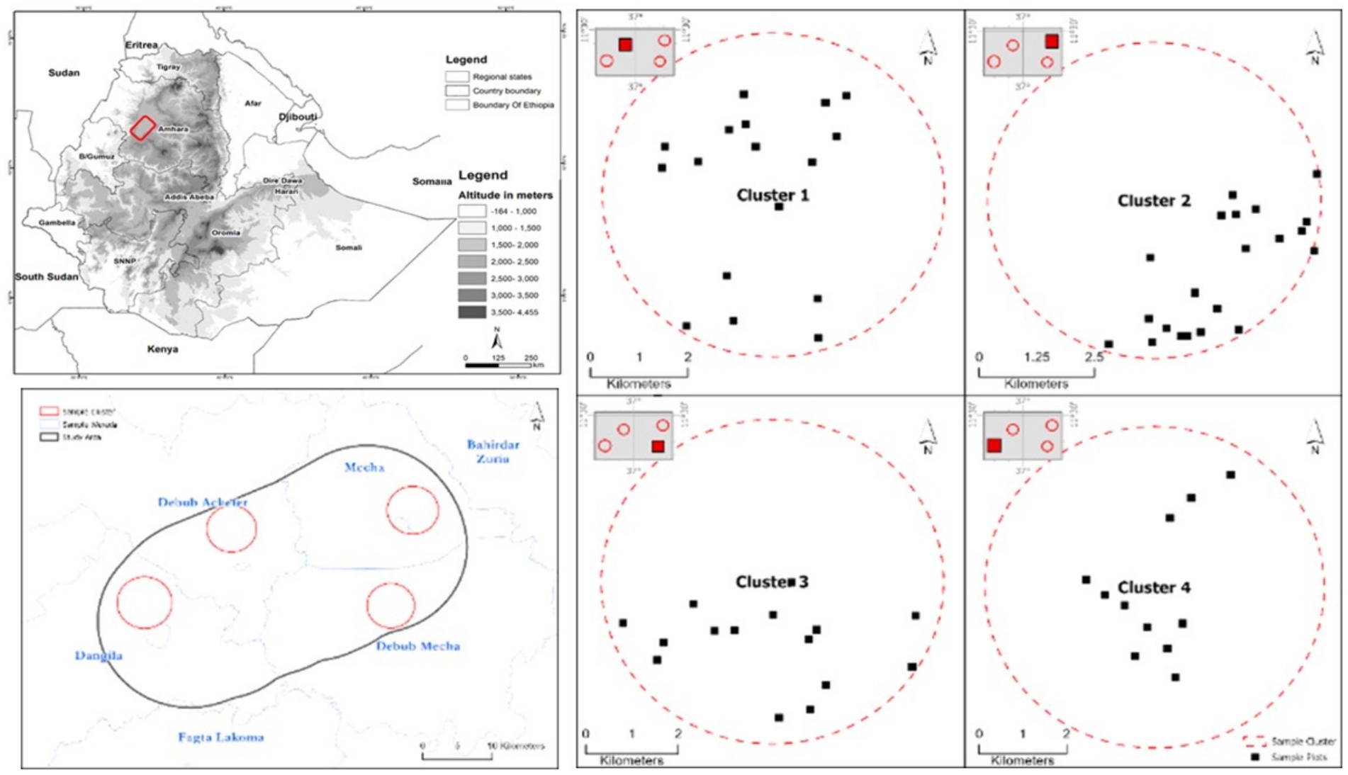
The study was conducted in smallholder-based mixed farming system in the highlands of Ethiopia. Specifically, among the eucalyptus conquered agricultural landscapes, the present study was conducted in North Gojam Zone of Amhara National Regional State, Ethiopia, considering 15 km buffer radius along the Dangila-Meshenti stretch, where dynamic conversion of crop fields to eucalyptus plantations and recently back to cereal fields (see Figures 1, 2).
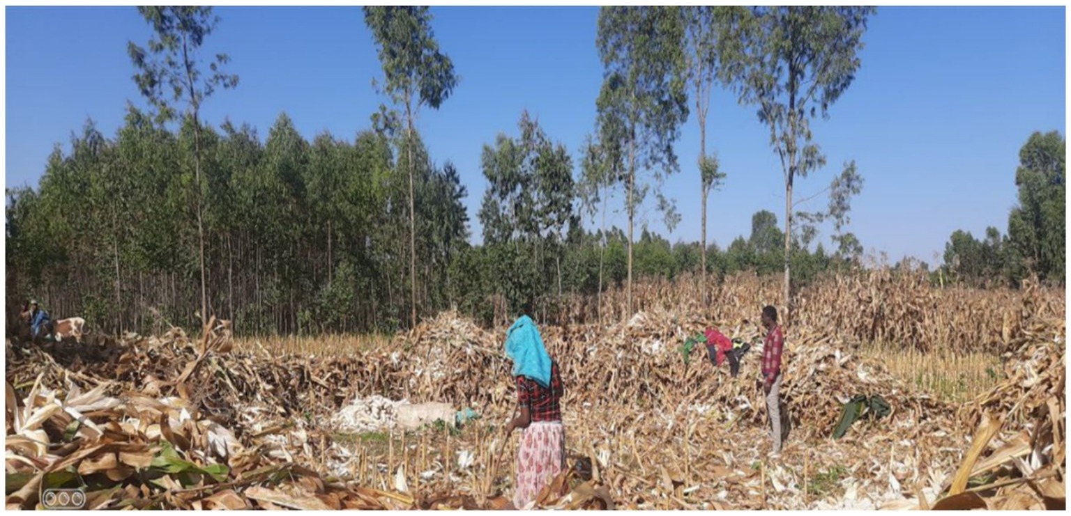
Figure 2. Peculiar mixed cropping system in a smallholder-based farming system. Farmers harvest dried maize crop grown in crop fields recently converted from eucalyptus plantation (center) and maize with pepper plots of a household (bottom left) and recently eucalyptus rotated cropping system. Photo credit: Alexander (2023).
Particularly, hotspot area where there is a recent and active conversion of eucalyptus lands back to cereal fields was vital. Furthermore, to understand the dilemma of eucalyptus and later linking the drivers, causes, and implications of a sudden land use conversion on the socio-ecological environment, hotspots were carefully selected for detailed analysis. Among the eucalyptus conquered agricultural landscapes, the north-western part of Ethiopia, particularly, the North Gojam Zone, was selected as a case study area for the present assessment. Very specifically, within the West Gojam Zone, authors took a 15 km buffer radius along the Dangila-Meshenti stretch (Figure 1). Geographically, the extent of the study area ranges between 1,235,069 m to 1,274,457 m North and 25,6234 m to 308,414 East (Figure 1).
The landscape is typically a floodplain characterized by a Nitisol. The main rainy season extends from mid-June to mid-September with maximum rainfall occurring between July and August. The mean annual rainfall is approximately 1,560 mm, and the mean annual temperature is approximately 20°C. Observation and reports from the zonal agriculture office show that the major land use system of the study area is annual crop production mainly cereal-based cropping system followed by pasture and woodlots (see photographs below). Within the 15 km stretch, four clusters of the study fall in four districts of the study zone, namely. South Mecha, South Achefer and Dangila.
The communities living in the study area are smallholders, who operate their fragmented and patched plots using the traditional method of farming with oxen-traction plows. As the landscape is largely flat, with deep red soils, it is suitable for various crops. However, since 2000, when timber service of eucalyptus trees became popular, planting eucalyptus trees around homesteads and cultivated landscapes became a common practice. Following massive plantation of the tree on previous croplands, eucalyptus woodlots become a big commodity in market outlets around and abroad. The major cross-border market outlets are Sudan and indirectly to Eritrea.
2.2 Study approach
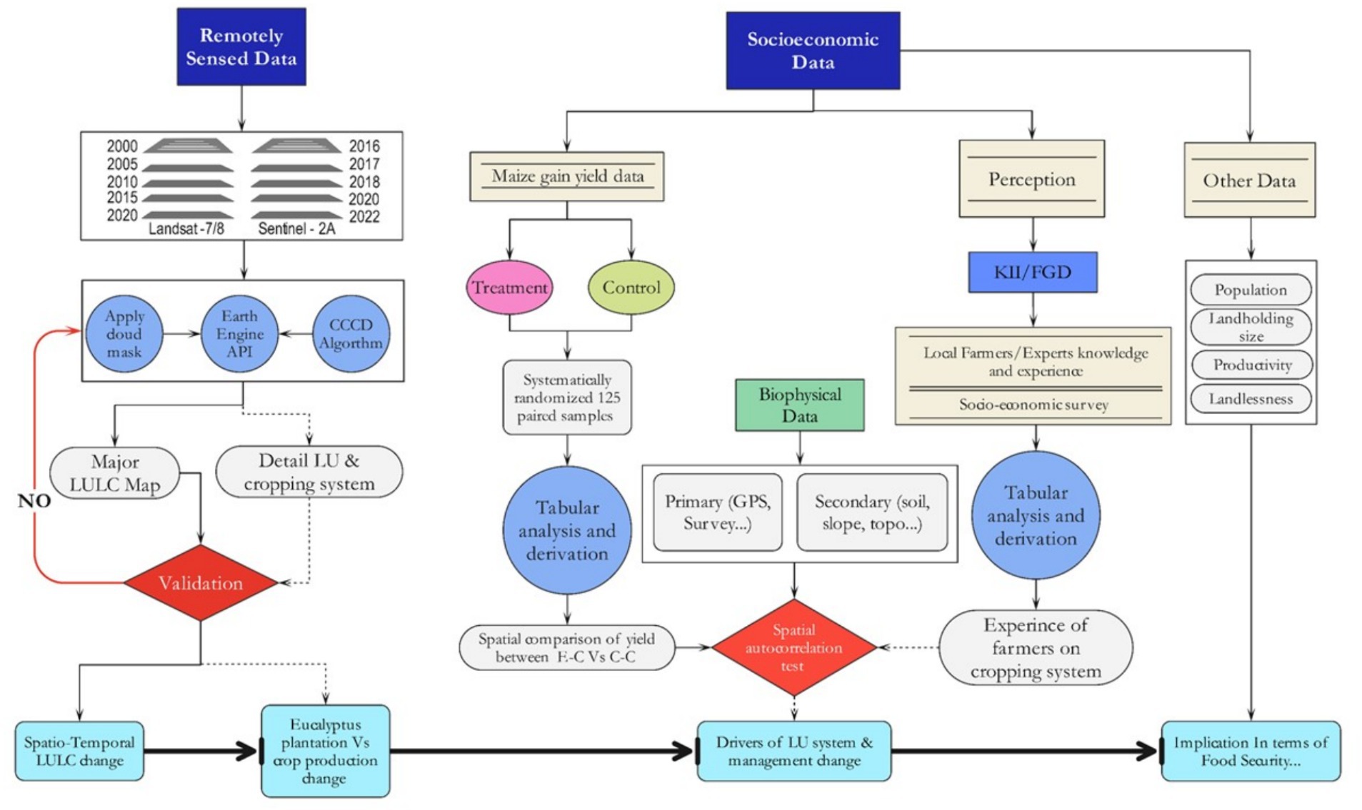
In smallholder-based mixed farming system, dynamic land use decisions happen at household and plot levels. The spatiotemporal dynamics of the varying land use and cropping systems change can be better understood when changes are properly linked with drivers and pressures using a well-designed research method and robust analysis framework. Therefore, for the present study, a widely used research framework, known as Drivers, Pressures, State, Impact, and Responses (DPSIR) model, was adopted from the European Environment Agency (EEA, 1999; Figure 3).
2.3 Data collection
The present study generated reliable facts from primary and secondary data sources by employing appropriate methods of data collection.
2.3.1 Biophysical data
As indicated in Figure 2, the present study used remotely sensed data for three purposes (i) to identify and map major LULC types; (ii) to detect changes and assess the spatiotemporal dynamics between different LULC; and (iii) to geo-locate changes and estimate rate of conversion of cropland into eucalyptus plantation and vice versa since 2000. For the latter case, Sentinel 2A imageries, downloaded from Copernicus open Data HUB, for the period 2016 to 2022 were used. For the former two cases, as Sentinel 2A data are unavailable for the years before 2015, authors used Landsat imageries, archived from USGS using Earth Explorer. Moreover, the present study used several geospatial data from WLRC-AAU available as EthioGIS database series. Authors also collected several biophysical data using ground survey checklists and Focused Group Discussion (FGD) and Key Informant Interviews (KII).
2.3.2 Socio-economic data
Sample size: Prior to fixing the location of samples and their number, a preliminary survey of the entire study area was made. Based on facts obtained from the preliminary survey, approximately 150 paired samples for the entire study were proposed. To determine the specific location and size of samples, spatial overlay analysis of major determinant factors that govern yield of cereal crops was performed. The criteria considered while geo-locating sample plots were (i) biological factors such as slope variation, soil type, and drainage condition, and (ii) socio-economic variations such as farm management, wealth, and land holding size. Afterward, their locality and specific location was analytically determined using systematic random sample generation tool available in ArcGIS.
Identifying and geo-locating sample fields: A pair of sample represent two plots that were considered as control and treatment. The control was all the time Crop-Crop (C-C) plots, and the treatment was Eucalyptus-Crop (E-C) plots in the 2022 production year. However, geo-locating the position of each of the 150 paired samples needed to get a farm field owned by one HH with two adjacent plots. In selecting the paired sample plots, authors considered the following criteria: (i) the control and treatment plots should be adjacent and owned by the same HH; (ii) eucalyptus clear-felled stands should have a maximum of 3 years and a minimum of 1 year since conversion; (iii) the age of the plantation should be <20 years and have the first and second coppice of tree that used to be managed with rotation in 5–6 years; and (iv) both eucalyptus clear-felled stands and the adjacent croplands need to have similar land use history prior to afforestation. However, as getting farm fields that fulfill all these conditions was very challenging, authors went to the field and physically relocated each pair of samples that fulfill these criteria.
Sample plot replication and plot dimension: While geo-locating 125 sample fields, the exact location of sample plots was defined considering factors that could determine yield variation. To avoid biased yield data collection, in each control and treatment plot, two replica sample plots (2 m by 2 m dimension) were identified (Figure 4).
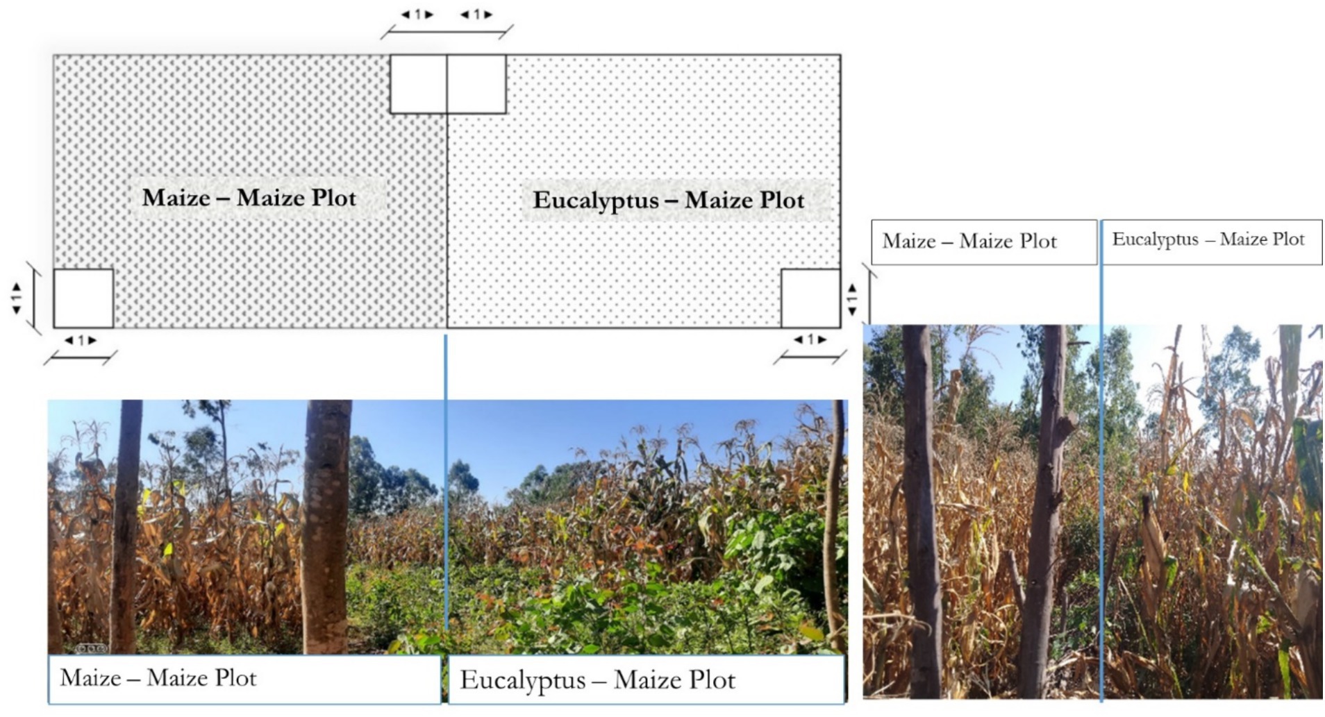
Figure 4. Chart depicting the sample plots designed to collect maize yield (top) and sample pictures of pair of sample farm fields (bottom and right).
Qualitative data: Approximately 35 household heads of smallholder farmers who were growing maize or other crops in their clear-felled stands were purposively sampled to participate in the FGDs and KIIs. Detailed information regarding the effect of reuse of areas previously planted with eucalyptus for crop production on soil fertility as well as growth and yields of crops was, then, explored through interviews using a semi-structured questionnaire.
2.4 Data analysis
Biophysical data analysis: To map LULC and LUS, two categories of mapping activities were implemented: (i) targeting detailed LULC and LUS mapping and (ii) focusing on specific LUS (eucalyptus stands). These two mapping and analysis activities were performed at two different spatial levels and time span. In the former category, the mapping and analysis of LULC and LUS was performed every 5 years from 2000 through 2020 using Landsat imageries covering the entire study area. The thematic details considered are approximately 10 detailed LULC types and are further grouped into four major LUS types (Table 1), namely, grain production, pasture production, timber and firewood production (forestry), and mixed/other use systems. In the latter category, focusing only on eucalyptus stands assessment, detailed mapping was done every year using Sentinel 2A and high-resolution Google earth imageries since 2016. This activity was performed only in four selected hotspots of clusters selected based on biophysical and agronomic factors such as types of crops, cropping calendar, and intensity of plowing.
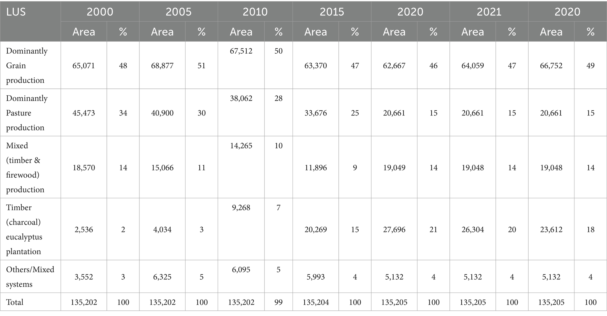
Table 1. Temporal dynamics of the area coverage of major LUS types existing in the study area (in hectare).
Socio-economic data analysis: To properly identify the real drivers/causes of the land use shift in the study area, authors divided the study period into five parts. In addition, on the basis of the dynamism recorded on spatiotemporal eucalyptus plantation, four major time spans were identified: 2000, 2000–2010, 2010–2020, and 2020 onwards. The collected socio-economic data were summarized, and descriptive results were generated using SPSS, STATA, Excel sheet, and OriginPro software. The results were interpreted by judiciously integrating the classified and summarized socio-economic data with the spatiotemporal LULC changes that were detected using remotely sensed imagery and by relating that further with the drivers and causes of the changes.
Within the convertor group, we also compared maize growth and yield differences between eucalyptus-cleared plots and non-eucalyptus adjacent plots. The number of Combs per stand and per area, and grain weight (wet and air-dried) were used as parameters for maize growth and yield comparison. To describe the economic implication of converting eucalyptus stand into cereal field and vice versa, two types of assessments were made, namely, (i) cost–benefit analysis and (ii) Opportunity loss analysis (calculating the difference between the optimum equivalent payoff (including services) from the production area and the actual payoff made from that area). These two assessments were performed considering three categories of ecosystem services or land use services from those plots, namely, timber production services (production forestry system), grain production services (crop production system), and pasture production services (livestock production system). The overall impacts of the LULC changes were drawn by integrating the socio-economic results from these three categories of assessments with the temporal LULC changes detected.
3 Findings
3.1 Land use system dynamics
The spatiotemporal dynamics assessment made on major LULC and LUS types during the two decades 2000–2022 shows a tremendous expansion of timber production at the expense of grain/croplands (Figure 5; Table 1).
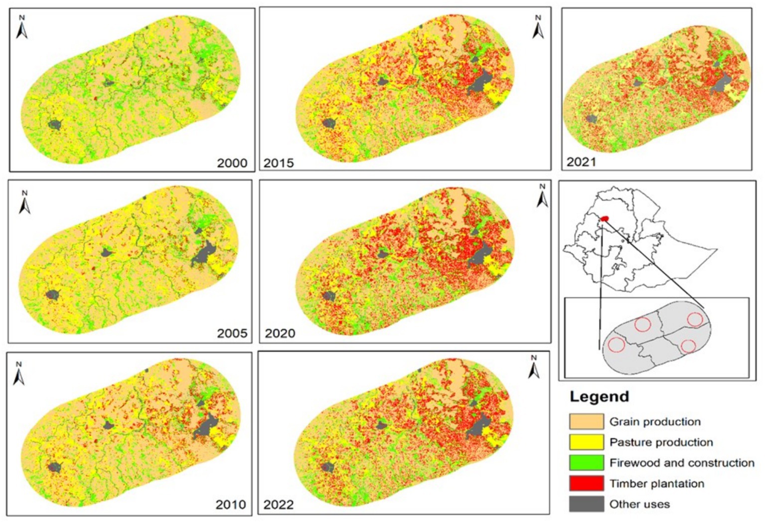
Figure 5. Spatiotemporal dynamics of major LUS identified in the study area (Source: Produced by Tibebu from Landsat 4, 5, 7, 8, and 9 Sensors).
According to our physical observation and the FGD results, crop production, mainly the production of cereals such as maize, finger millet, and wheat are the dominant crops covering 95% of the cultivated landscape in the study area. As depicted in Table 1 and Figure 5, cropland is the dominant land use system covering almost half of the study area.That is followed by eucalyptus plantation, pasture, natural woody vegetation, and other uses such as settlement and infrastructure covers the remaining 50% of the study area, ranked in their order of area coverage from higher to lower share. In fact, the distribution and coverage considerably vary in time and space. Looking at their percent cover change, cropland seems stable, but, if the spatiotemporal comparison is based on area (in ha), cropland is the most transformed land use. It covers approximately 48% of the landscape in 2000, but in 2005, its cover rise into 51% as a considerable grassland was converted into cropland due to land redistribution and consolidation happened in 2003/2004. However, in the period between 2005 and 2010, cropland lost approximately 1% and accounts again 50% share of the study area. According to the statistical facts, the period between 2005 and 2015 was the time when the coverage of eucalyptus plantation showed a substantial increment. As a result, cropland coverage reached 47% in the year 2015. In 2020, the LULC was almost stable, and after 2021, the area under crop field increased from 46% in the year 2020 to 47% in the following year and further up to 49% in 2022. Contrarily, except in the period between 2000 and 2005, pasture land has been continually declining since 2005. Other use systems (representing infrastructure and settlements) have considerably expanded between the year 2000 (3%) and 2010(5%), mainly at the expense of croplands. The natural landscape (a mixed natural vegetation) has continually suffered a massive degradation between 2000 and 2015.
3.1.1 Spatiotemporal dynamics of eucalyptus plantation, 2016–2022
The information generated from Landsat imageries can have 13–16% error as the accuracy of the maps ranges from 84 to 87%. The red pixels of the maps produced from Landsat imageries (Figure 6) represent eucalyptus plantation. Comparing the coverage of eucalyptus in 2015 (Figures 4, 5), the map produced from Sentinel image encompasses a larger coverage of eucalyptus plantation in the year 2016. Indeed, based on mapping results of Landsat imageries, a considerable eucalyptus area expansion happened in the period between 2005 and 2015. Because eucalyptus plantation can exist with a spatial extent lower than the pixel size of Landsat imageries, authors produced Sentinel-based eucalyptus maps for the period between 2015 and 2022, which implies that Landsat-based maps could underestimate eucalyptus plantation (13–16%). The present study made a focused assessment on eucalyptus plantation using Sentinel images (2016 till 2022).
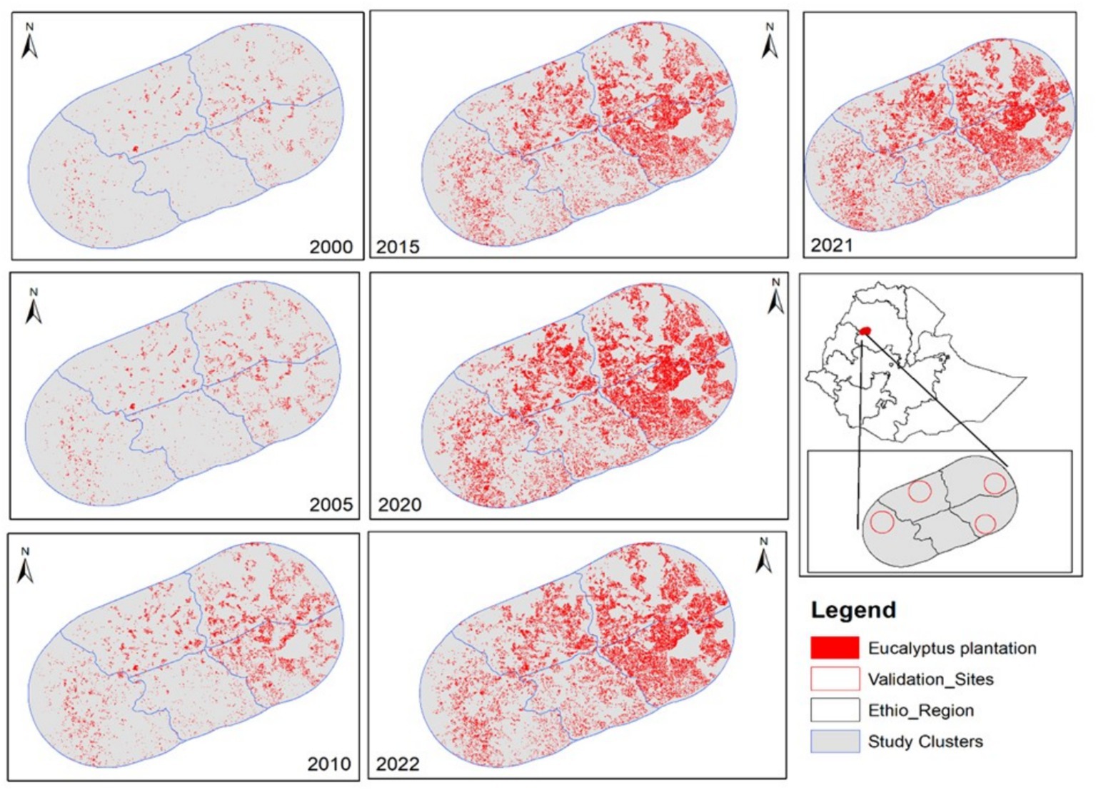
Figure 6. Spatiotemporal dynamics of eucalyptus stand (Sentinel-based mapping; Source: Produced by Tibebu from Landsat 4, 5, 7, 8, and 9 Sensors).
As depicted in Table 1, the year 2017/2018 was the time when expansion of eucalyptus plantation reached its climax. In the assessment base year, the coverage of eucalyptus trees was trivial (2%). A double increment was recorded in the period between 2000 and 2005, and a triple rate of increment was recorded in the period between 2000 and 2010 (from 2 to 7%). Indeed, its temporal expansion was exponential until 2015.
3.1.2 Eucalyptus plantation dynamics at selected cluster of hotspots (2000–2022)
Still, the maps produced using Sentinel 2A imageries have overestimated and underestimated eucalyptus plantation. To clearly capture such LUS changes that happen at a smaller extent, authors further conducted a detailed assessment. Figure 7 depicts high-resolution-imagery-based LUS mapping performed in four systematically selected case study sites/clusters. The accuracy of these maps is above 95%, implying that there is no overestimation or underestimation of eucalyptus plantation. In all the clusters, eucalyptus plantation revealed a continuous increment with a varying intensity. Comparatively, among the four clusters, Cluster 2 experienced a considerable change on the landscape. Such change had happened mainly at the expense of pasture and croplands.
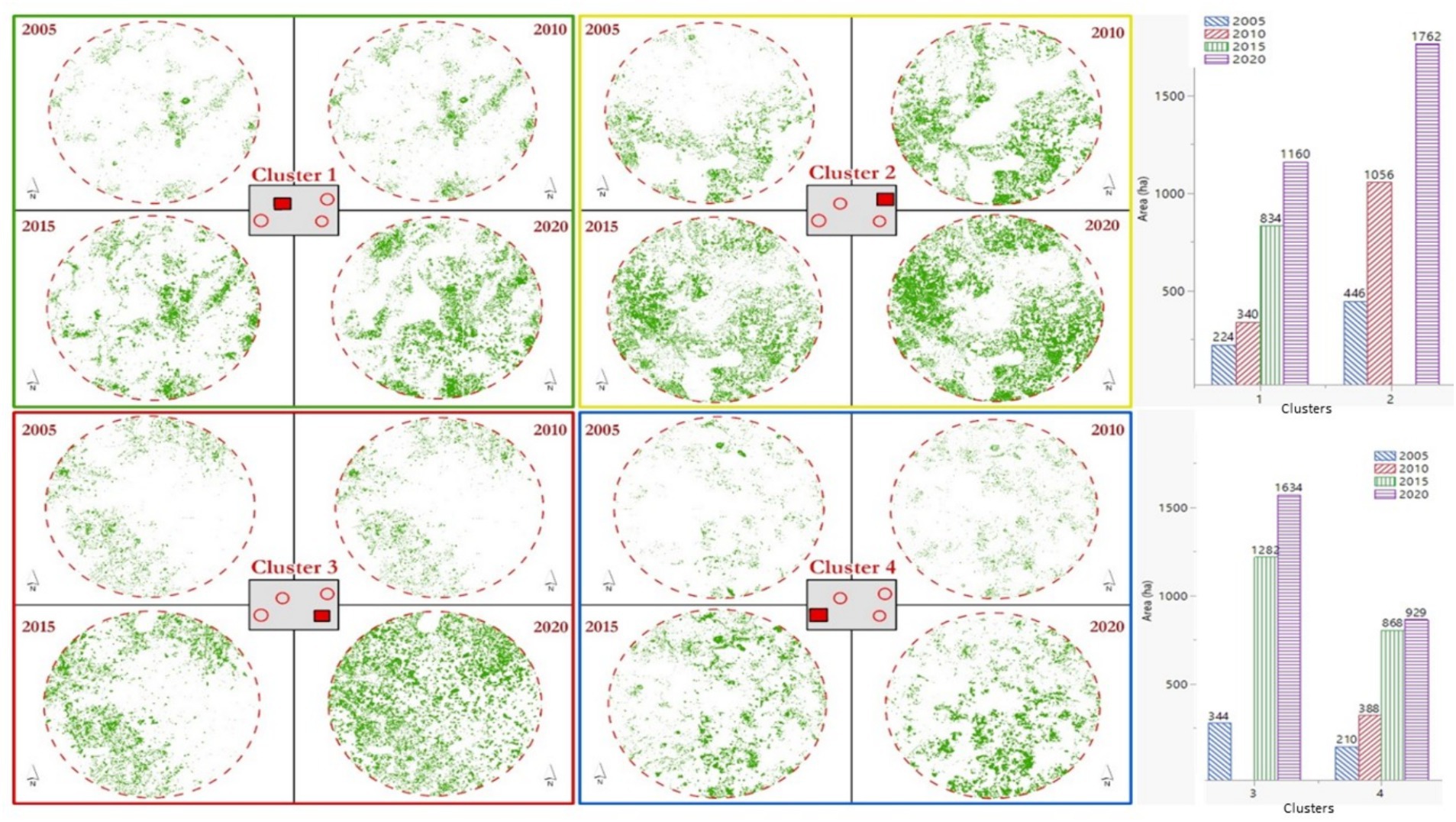
Figure 7. High-resolution-image-based eucalyptus stand dynamics mapping and change detection on selected hotspots and summary statistics. High-resolution (Google earth imageries with <1 m pixel size) 2005–2020 change analysis.
Approximately 30% of the landscape in Cluster 2 has been transformed from cereal and pasture producing landscape into eucalyptus plantation (Figure 7).
3.2 Intensity and direction of LUS transitions in the four clusters of hotspots
A recently emerging new land use practice, mainly, planting eucalyptus trees on productive croplands and pasture fields, brought a considerable transformation not only on the biophysical landscape but also on the socio-economic conditions However, given the practice of planting eucalyptus trees in a smallholder farmers’ landscape at a very smaller spatial extent, lesser than the pixel size of Landsat even Sentinel imageries, the produced maps may not show the reality that happened on the ground. This in turn hindered authors to determine on map crop to eucalyptus and eucalyptus to crop conversions. To clearly map and characterize such important transformations, the authors did a detailed mapping and change analysis. For that purpose, on few selected clusters, the authors made a detailed mapping that integrates high-resolution Google earth, Landsat, and Sentinel 2A imageries supported by a comprehensive field survey. The field survey data include GPS-based tracing of un-mappable eucalyptus stands, insensible transitions and conversions, and historical land use systems. Change dynamics with direction of change (transition and trajectories that show the gain and loss or what changed from and to what) is provided in Table 2.
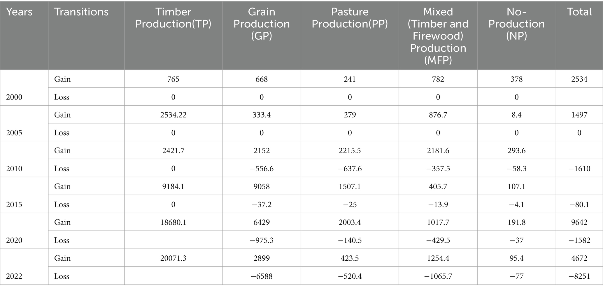
Table 2. Total gain and loss (area in ha) between eucalyptus plantation and other LUS (Supplementary data).
3.3 Areal gain and loss between eucalyptus plantation and other LUS in the four clusters of hotspots
As getting higher resolution imageries of the study area for every year was challenging, ‘from… to…’ change analysis was done taking four millstone periods of change that properly show the nature of changes. Table 2 presents the overall gains and loss between eucalyptus plantation and major LUSs, and Supplementary Figure 1 provides graphical representation of the trajectory of changes.
Based on higher resolution imagery-based change assessments made on specific hotspot areas, a decreasing trend in eucalyptus plantation was recorded in the period between 2020 and 2022, accounting for approximately 40% decline or area loss compared to the previous period (i.e., 2015 and 2020). Area wise, eucalyptus plantation was expanded to a total area of 1498 ha, 6842 ha, and 11,078 ha during the periods 2000–2005, 2005–2010, and 2010–201 but then reduced to 9642 ha during 2015–2020 and further down to 4672 ha during 2020–2022. Of these changes, higher areal gains for eucalyptus plantation were made at the expenses of natural vegetation and pasture, which, respectively, accounted for 59 and 19% of the expansion area during 2000–2005 and 22 and 40% during 2005–2010. In the periods after 2010, above 80% of the gains for eucalyptus expansion were from croplands.
As depicted in Supplementary Figure 1, the TP bar representing timber production service area (dominantly covered by eucalyptus Plantation) never lost to any LUS. In all the periods, the area coverage of TP (eucalyptus plantation) expanded continually and exponentially growing until 2020, but, in the year 2021 and 2022, the TP service area lost a considerable area to crop field, which is linked to substantial LUS transformation from plantation to cereal production.
3.4 Drivers and causes of conversion between eucalyptus trees and cereal crops
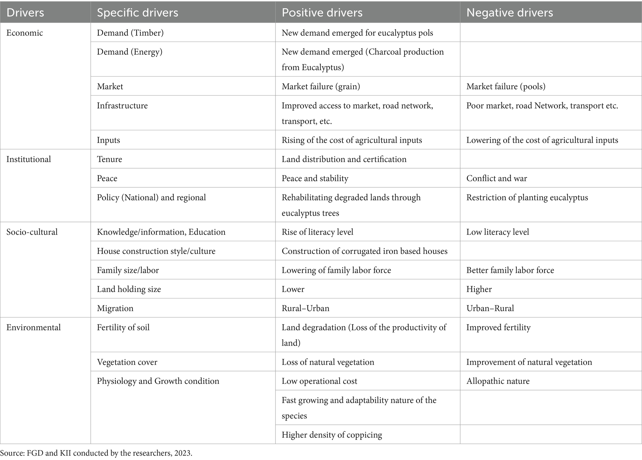
Based on the nature of change as well as the identified millstones of change, the present study identified pertinent drivers, classified them into four categories (socio-cultural, economical, institutional, and environmental), and further described their impact as positive or negative. Table 3 summarizes major drivers that contributed most to the expansion and those to the abrupt reduction of eucalyptus plantation in the study area.
As depicted in Table 3, the drivers and causes are listed according to their importance in a descending order. In our assessment, among the listed drivers, respondents/discussants ranked economic drivers first, followed by institutional and cultural factors. Environmental factors were ranked the least among the drivers. According to the results of the KII and FGD narratives, demand for fuelwood, and construction pols, market/price and accessibility (distance to road, market, and settlements) influence decisions of transforming from cereal to timber production landscapes or vice versa.
3.5 Implications of converting eucalyptus plots to cereal fields and vice versa
Impact and implication of LUS changes were assessed in three dimensions: (1) biophysical (physical landscape transformation), (2) socio-cultural (land use and/or management/practice change), and (3) economic indicators. The findings of the assessments are presented in the following sections.
3.5.1 Implications on biophysical landscape
In the study area, the expansion and removal of eucalyptus trees plantation lead to biophysical landscape transformation as an immediate and prominent impact (see Figures 8, 9; Supplementary Figure 1, for example). For instance, planting eucalyptus trees had been in cluster 2 covering only 7% during 2005. In the same area, over 15 years, eucalyptus covered almost 47% of the area, which transformed the physical landscape of the smallholders’ land use system (Figure 6). Such amount of physical landscape transformation does have various socio-cultural, economic, and ecological implications.
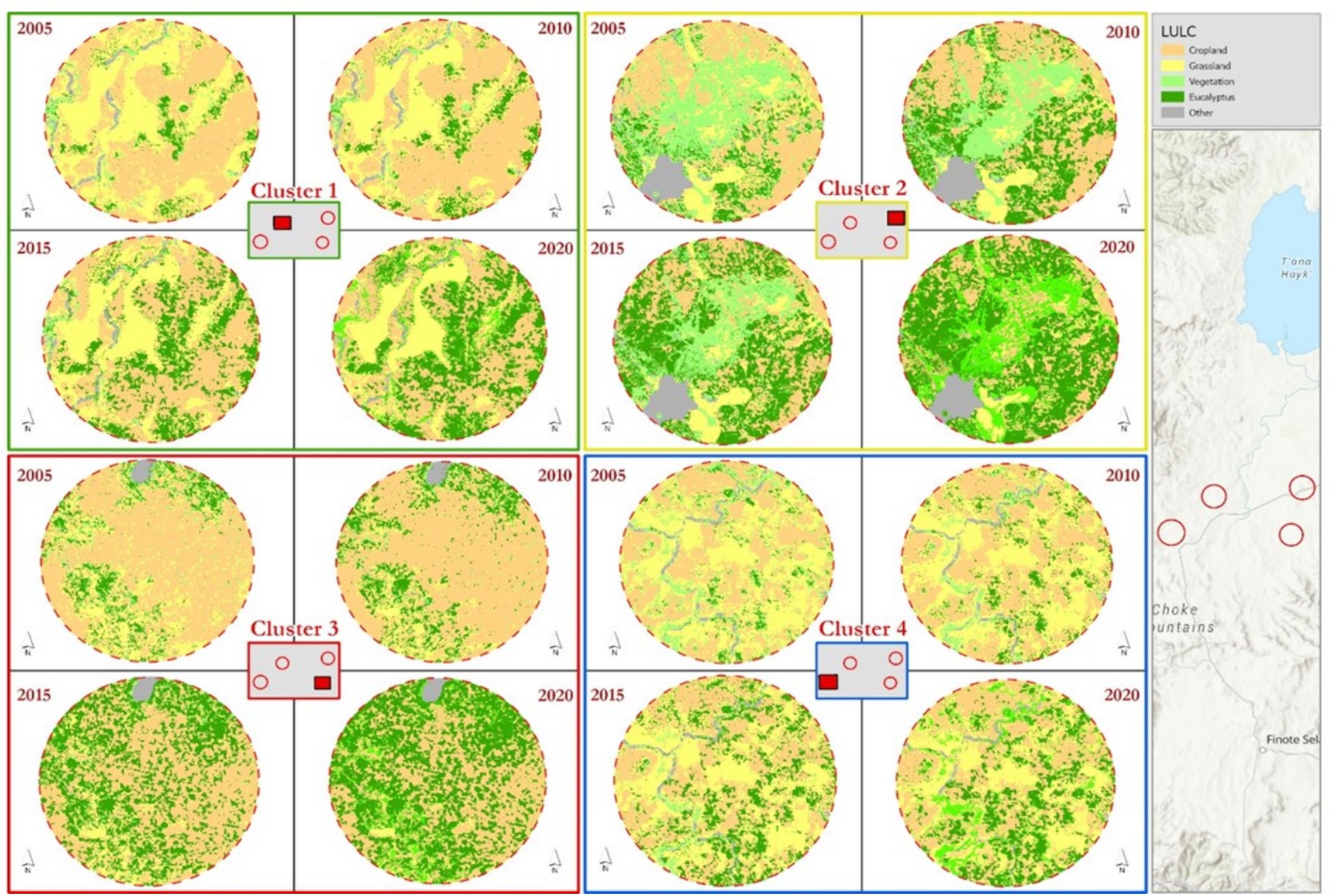
Figure 8. Spatiotemporal dynamics between major land use systems and eucalyptus planation in the study area, 2000–2020 (multi-source data outputs obtained from hybridized mapping and analysis approaches).
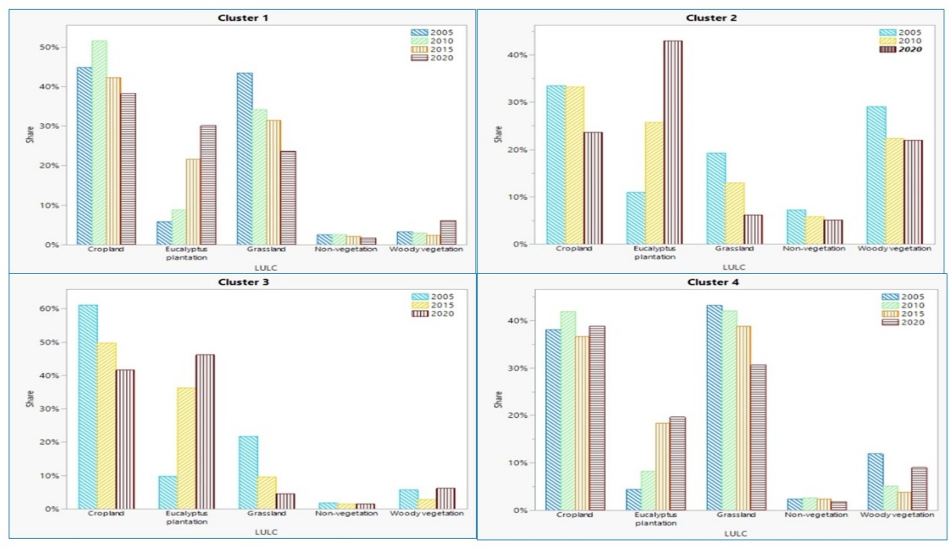
Figure 9. Statistical facts about temporal dynamics of major land use systems in the study areas, 2005–2020.
3.5.2 Socio-cultural implications
3.5.2.1 A new land use/management system/practice emerged
Quite many times, literature has been blaming the practice of growing eucalyptus trees alongside of cereals due to its allopathic effect. The present study findings show that, for smallholder farmers who have very limited land and fragmented plots, the benefit of growing eucalyptus trees outweighs its perceived negative impacts. According to FGD respondents, and verified by author’s field observation, against the alleged myths of the tree, the practice of the planting eucalyptus trees alongside cereal fields either as farm border or as striping between cereal fields is intensifying time to time. Pictures presented in Figure 10 show how smallholder farmers slowly reshaped their practice while domesticating eucalyptus trees species for agroforestry.
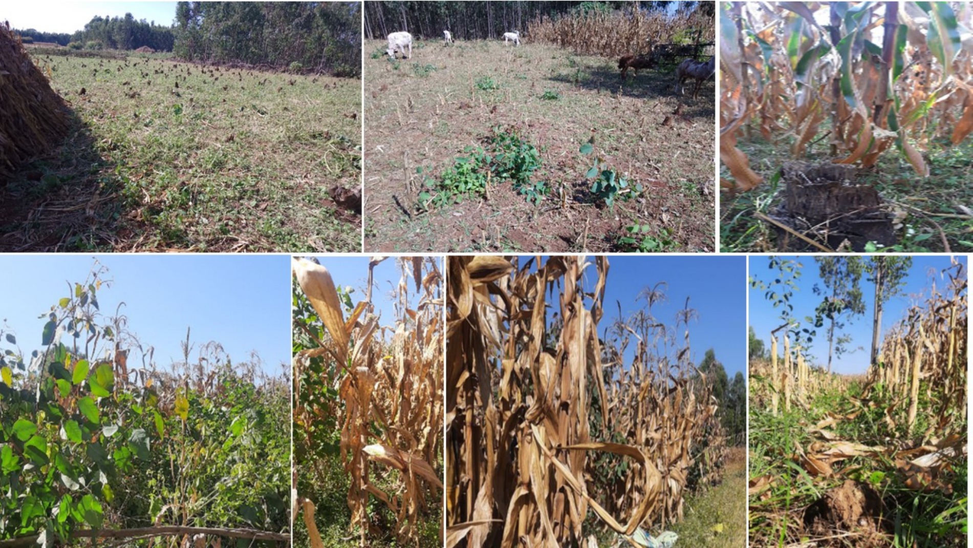
Figure 10. Top left, middle, and right pictures portray eucalyptus-maize field after harvest specific management where farmers do not allow the coppice to grow, (right), the farmer allows the coppice to grow, whereas the bottom left, middle, and right pictures portray another land management by farmers, where farmers allow eucalyptus to grow with maize crop. The later could indicate the process of acclimatization of eucalyptus trees in the cereal production landscapes of smallholder farming systems.
3.5.2.2 Implications of eucalyptus plantation to cereal conversion and vice versa on land tenure
Assessment findings revealed that converting cropland to eucalyptus plantation could have an indirect impact on tenure security and farmland holding size. Over the analysis period, approximately 23,000 ha of land, which could be cultivated, was converted into eucalyptus plantation. Equivalently, it would support the livelihood of above 30,000 HH to lead smallholder-based farming. In addition, dividing the total eucalyptus planation areas (Table 1; Supplementary Table 1) in the years 2000, 2005, 2010, 2015, and 2020 by the long-term average land holding size in study area (averagely 0.8 ha of land per a household), approximately 3,251, 5,172, 11,882, 25,986, and 35,508 households lost their chance to establish agrarian livelihood system or would become landless in each respective year. In other words, the conversion of the cropland to eucalyptus contributed to a decrease of the agricultural land holding size from 0.9 ha per household in the early 2000s to 0.5 ha in the early 2020s.
3.5.3 Ecological implications
The ecological implications of converting eucalyptus stand into cereal production were assessed taking three ecological impact indicators, namely, growth condition (# of stand per area), comb size and number (#/stand), and productivity (gross grain yield in terms of kg/area).
Effect on Maize stand and Maize comb: According to our physical observation and the information shared by the participants in the FGD and KII, an improved maize grown in sample plots where farmers cleared eucalyptus stand and planted maize showed higher growth performance than maize grown on plots that had been cereal fields in the previous year. According to the data collected from samples plots, approximately 7% of the sample plots in EC have 2/3 combs per stand, whereas only 3% of the CC samples have 2/3 combs per maize stand. A higher dry matter production were also recorded on maize plants established on clear-felled eucalypt stands.
Effect of clear-fell eucalyptus on cereal grain yield: Data on yield differences were collected from four representative clusters and 125 paired and adjacent sample plots. Alike the biomass (maize stand and Comb/stand), the yield difference assessment result showed a higher grain yield was recorded from plots with E-C plots than C-C plots. Detailed sample by sample yield differences is presented in Figure 11.
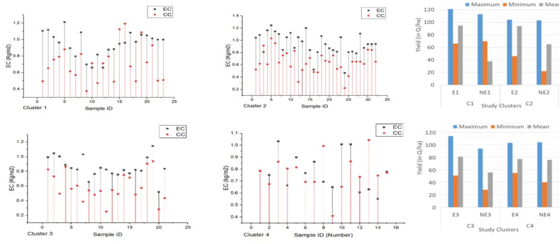
Figure 11. Yield differences recorded between E-C and C-C sample plots collected from four clusters of hotspots (the yield is an average value calculated from two samples each having 2*2 m, that is, but presented and expressed in terms of kg/m2). Parallel left side charts present yield gap comparisons between the four clusters and the national and the local reference experimental yield of maize. The Y-axis represents the yield in terms of kg/m2, and the X axis represents sample cods in each clusters. The circular red dots represent the grain yield of a sample taken from C-C plots, and a rectangular black dots represent the grain yield of a sample taken from E-C plots. The black line shows the yield differences recorded between the paired plots.
As depicted in Figure 11, in EC samples, the minimum and maximum wet weight ranged from 0.5 kg/m2 to 1.2 kg/m2. This is equivalent to 47–120q/ha, whereas in CC samples, wet weight ranged from 0.24 to 1.1, kg/m2, which is equivalent to 24 to 94q/ha. The yield difference in each sample within a cluster or across clusters is presented in Figure 11. In general, the average yield differences recorded on EC samples from CL1, CL2, and CL3 exceeded the yield collected from CC sample plots by 19, 30, and 20%, respectively. Exceptionally, the average yield difference in CC exceeded the EC sample plots by 1%. Based on yield data recorded on CL1, CL2, and Cl3, we can generalize that the practice of converting e eucalyptus to cereal-based crop production gives a higher yield, at least in the first production year. Contrarily, the average yield difference between E-C and C-C samples revealed that half of the samples showed a higher yield in CC than EC, and half of the samples show there is a higher yield in EC than in CC. Thus, the recorded differences on sample plots of cluster 4 make such generalization difficult.
3.5.4 Economic implications
3.5.4.1 Cost–benefit approach
This section presents the results of the trade-off between agricultural production and timber (forestry) land use systems, which compares grain production (taking Maze crop) in agriculture land use against timber (eucalyptus pole) and non-timber products (firewood and charcoal) in eucalyptus plantation. For the purpose, cost–benefit analysis and service area-based comparative analysis were employed. The cost–benefit analysis was performed by comparing input applied/production cost against outputs produced/benefits, across 2000 and 2020 production years (Supplementary Table 1). To obtain economic value of land use per hectare, the total revenue, cost, and profit of each land use option were divided by the total land area under cropping use versus eucalyptus plantation. Supplementary Table 1 presents the trade-off assessment results from the cost–benefit approach.
The study landscape that covers approximately 135, 400 ha of land, of which 50% used to produce grain, would generate above 117 million dollars per year. The cropped area dynamics estimated for five different periods revealed that approximately 67,071 ha, 68,877 ha, 68,415 ha, 63,370 ha, 62,667 ha, 64,059 ha, and 66,752 ha of land was converted from crop field to eucalyptus plantation. In monetary value, the net average equivalent monetary value is estimated to be 7, 17, 47, 88, and 116 million USD$ revenue in the respective periods. On the other hand, the monetary-based landscape productivity performance of the area is higher when used for cereal production than eucalyptus plantation. Contrarily, eucalyptus plantation-based land use shows a higher performance when evaluated from cost of production against total net benefits. In terms of total net economic benefit, cereal production surpasses eucalyptus plantation.
3.5.4.2 Service area-based trade-off assessment
Table 4 presents statistical facts about area-based opportunity lost or an equivalent opportunity that would contribute to ensure local level land supply to the grain production system, which in turn affect the tenure as well as the food security situation at large. By taking an alternative land use system, that is, maize crop instead of eucalyptus plantation, opportunity loss in terms of service area to be used for maize production was calculated. As indicated in Table 4, in the years 2000, 2005, 2010, 2015, and 2020, farmers in the community have planted eucalyptus on approximately 2,536, 4,034, 9,268, 20,269, and 27,696 ha of land, respectively, that implies an equal amount of land would have been used to produce grain in each year. Taking the average maize productivity of the area for each year (Table 4), approximately152,160, 229,938, 472,668, 972,912, and 1,606,368 quintal of maize grain would have been produced in each year. Taking 1.4 kg/day food as a food demand of a person per day, the total amount of food demand per year per person was calculated and accounts 5 quintal of food per year per person. Dividing the total maize grain that would have been produced in each year (Table 4), the total population that could be fed on the grain was estimated at 30,432, 45,988, 94,534, 194,582, and 321,274 in the years 2000, 2005, 2010, 2015, and 2020, respectively. Equivalently, the total maize grain produced in each year would contribute to sustain approximately 5,072, 7665, 18,907, 38,9176, and 80,318 households, in the years 2000, 2005, 2010, 2015, and 2020, respectively.
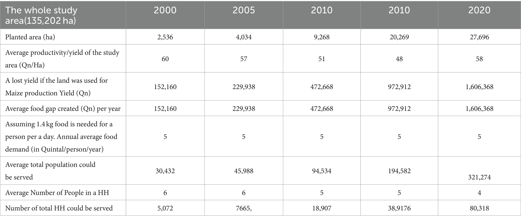
Table 4. Implication of eucalyptus stand conversion to cereals and vice versa on the coverage of grain producing landscape.
4 Discussion
The present study examined the type, extent, intensity, and impact of landscape transformation due to eucalyptus trees plantations in the North Western part of Ethiopia. As far as concerned to the extent of landscape transformation, among the five systems, grain producing landscape is the most transformed land use as it happens in the entire rainfed agricultural area of Ethiopia (Kassawmar et al., 2018b). Of the assessment periods, the period between 2000 and 2005 is a time of massive transformation (Figures 5–9). A considerable grassland was converted into cropland attributed to land redistribution and consolidation happened in 2003/2004 (Takada et al., 2022). On the other hand, the period between 2005 and 2015 was the time when the coverage of eucalyptus plantation showed a substantial increment. These findings are supported by other similar research studies (Alemayehu et al., 2023; Jenbere et al., 2012). In the period between 2015 and 2020, exceptional change had happened. While the coverage of eucalyptus trees reached its climax in the year 2017/18, the coverage of croplands slightly reduced. As depicted on Tables 1, 2, except in the period between 2000 and 2005, pasture land has been continually declining since 2005, which is mainly eucalyptus plantation and land redistribution effects. The findings of similar studies such as (Gedefaw et al., 2020; Belay, 2010) also support our results. As far as concerned to natural vegetation dynamics (a mixed natural vegetation) has continually suffered a massive degradation between 2000 and 2005. However, as several studies confirmed that the years between even before 2000 are critical times as a relatively higher vegetation cover loss was recorded (Kassawmar et al., 2018b). Since 2010 up until 2015, periods were recorded as time of stability for natural vegetation which is linked to vegetation restoration movement (Mulugeta, 2014).
Mapping and monitoring land use system change in smallholder-based mixed farming is tricky (Kassawmar et al., 2018a). As learned from the assessment results of the present study (Tables 1, 2; Figures 5, 6), the intensity, rate, and direction of changes happening between different land use systems are very complex, which needs contextually designed assessment methodologies (Kassawmar et al., 2019). Applying even the best available imageries and state-of-the-art technologies, it is challenging to precisely show the dynamics between land use systems with eucalyptus plantation because eucalyptus plantation can exist with a spatial extent lower than the pixel size of imageries used to map and study the dynamics. Even authors produced Sentinel-based eucalyptus maps for some period, some important changes never been detected and estimated properly. Nonetheless, the results of the annual eucalyptus plantation mapping showed a climax expansion, which happened in the year 2017/18. A study by Alemayehu et al. (2023) has detected also a similar phenomenon. Compared to the decadal and bi-decadal assessment, mapping eucalyptus stand every year allows to not only improve the accuracy of the maps and generate accurate evidence but also understand the plantation management practices, mainly planting, harvesting, and land use conversion. Moreover, an interesting and unperceivable changes were detected when authors employed high-resolution imagery-based mapping and change analysis on smallholder farming systems. According to the facts recorded from a high-resolution imageries and change analysis, a revers transition is recorded since 2020. The coverage of eucalyptus plantation started to decline since 2020. In total, within 2 years (between 2020 and 2022), smallholder farmers have converted approximately 5% of their eucalyptus plantation to grain fields (Figures 7–9; Table 2). From the hotspot-based results, authors realized that earlier times expansion of eucalyptus was largely on the expense of natural vegetation and grasslands, while recent expansions were on the expense of croplands.
Several research studies have been conducted to know the drivers and discern the reasons of eucalyptus expansion (Jaleta et al., 2016; Alemayehu and Bewket, 2018; Alemayehu et al., 2023; Jenbere et al., 2012; Chanie et al., 2013; Tesfaw et al., 2022), but drivers and reasons to removing eucalyptus and replacing with cereals are unknown as such a practice is a recent phenomenon. Previous research evidence depicted that the common causes and drivers responsible to most land use system changes fall into three categories: socio-economic, institutional, and environmental (Alemayehu and Bewket, 2018). Facts generated by the present study on the nature of change as well as the identified millstones of change, approximately 20 specific drivers, falling in to four general categories (socio-cultural, economical, institutional, and environmental) of drivers were identified. Based on the FGD-based ranking of drivers, respondents identified economic factors mainly market failures, as the main reason for farmers to abandoning eucalyptus trees and growing cereals. This agrees with what Alemayehu and Bewket (2018) reported about high income earned from eucalyptus pols selling as a leading of the major drivers for the farmers to plant eucalyptus (Alemayehu and Bewket, 2018; Alemayehu and Melka, 2022). Although the majority of the respondents of the FGD ranked economy as the most decisive factor for the measured changes, the suitability and productivity of the landscape made Mecha district a known eucalyptus plantation belt.
LUS in smallholder-based farming tends to be affected even by modest pressures. The present study made a simple impact assessment, taking three evaluation measures/indicators: (1) biophysical (physical landscape transformation); (2) socio-cultural (land use and/or management/practice change); and (3) economic indicators. Change in land use practices could have multifaceted implications. According to the hotspot-based landscape transformation assessment findings, over 15 years of time, eucalyptus has invaded and transformed approximately 30–47% of the grain dominating landscape (Table 2; Figures 7–9). However, a reversing physical landscape transformation recently happening in smallholders’ could be taken as an important supporting evidence that the main driver of planting eucalyptus plantation is economic and political factors (Table 2).
As smallholders are always questioning the performance, efficiency, and risks related to the newly emerged practices, the landscape is always in state of change driven by complex drivers and pressures (Jagger and Pender, 2003; Alemayehu and Melka, 2022; Sang et al., 2023). Since the time of commoditizing eucalyptus trees (as of 2000) in the area, the way smallholders used their fragmented and small farm plots has been continually transformed. Over the millennia, the dilemma of growing eucalyptus trees with crops remain a debatable issue due to its alleged allopathic effects (Jaleta et al., 2016; Feyisa et al., 2018). Against such alleged thoughts, smallholder farmers have been growing the tree alongside of cereal fields either as farm border or as striping between cereal fields (Alemayehu and Bewket, 2018; Jenbere et al., 2012). Ignoring about the risks and worrying more on land scarcity pressures, farmers continued growing the tree mainly for efficacy and profitability reasons (Alemayehu and Melka, 2022). When authors asked about their reasons of planting the tree regardless of the negative impacts, the majority of the respondents said that no other practices other than this magic tree helped us in fulfilling our immediate and critical demands (such as energy or fuelwood, construction/timber, and cash). Respondents underlined that it is not only the question of fulfilling their domestic fuel wood and timber demand but more about the income. As a result, growing eucalyptus trees is a dynamic agricultural practices evolving with different agricultural practices and has become a deep rooted agro-culture of the society to the level farmers are adapting the tree to make it an agroforestry tree (Kidanu et al., 2004; Kidanu et al., 2005; Ceccon, 2005; Sun et al., 2021; Rose and Adiku, 2001). Given landscape changes are driven by intricate and multifaceted drivers, they always accompanied by newly emerging land use systems evolved with unintentional land management practices. Interestingly, as detected by the recent satellite images and confirmed by FGDs, following a declining market demand for eucalyptus, the income from eucalyptus trees has declined (since 2020). As a result, farmers started to removing eucalyptus and planting cereals on the same field. Such dynamic land management systems confirm that smallholder farmers are risk-averters who can immediately apply an adaptive LUS in response to any unforeseen pressure or driver that negatively affect existing practices. Particularly, a new succession of land use system from eucalyptus fields to maize and vice versa is a transformative land use system, which could falsify the alleged myths about eucalyptus species in the agricultural sector (Daba, 2016; Jaleta et al., 2016). Although there is limited scientific evidence that shows planting eucalyptus trees is an agroforestry practice (Kidanu et al., 2004; Ceccon, 2005), authors got convinced that rotationally growing eucalyptus trees with cereals will be a likely agricultural practice. Such overlooked implications of land use shifts deserve to be studied. FGD and KII results show that converting croplands to eucalyptus plantation is considered as an important indirect and underlying cause for inheritance linked loss of land holding and use rights, which instigated household level conflicts, and often ended up without migration and landlessness. On the basis of our FGD, KII, and survey findings, expansion of eucalyptus plantation escalated land scarcity and land-related conflicts spanning from household to community and state.
Land use transformation in the study area has direct and meaningful socio-cultural impacts. Over the analysis period, estimates show that above 23,000 ha of productive cropland was converted into eucalyptus plantation. If it were used for crop production, that land would equivalently accommodate above 30,000 HH or 100,000 persons (Table 4). In other words, the conversion of approximately 23 thousand hectare of cropland into eucalyptus plantation mean that an equivalent of 30, 00 HHs lose their farmland to eucalyptus, a situation which aggravates the extent of cropland to population ratio by half and subsequently high rural out migration among the rural youth. Also, the volume of grain production and the entire food systems and the livelihood of the society are negatively impacted by shifting the land use system.
The ecological implications of converting eucalyptus stand into cereal production have been thoroughly studied by several researchers (Daba, 2016; Jaleta et al., 2016; Michelsen et al., 1993; Chanie et al., 2013; Yitaferu et al., 2013; Nasrallah et al., 2020). Growing eucalyptus species can capture nutrients, reduce nutrient leaching, and improve soil water holding capacity sustainably compared to cropland (Tully and Ryals, 2017a; Tully and Ryals, 2017b). Nutrient recycling is required to maintain soil productivity at the field scale and biogeochemical cycling at regional and global levels (Ghaley et al., 2014). This is the reuse of organic residues from agricultural biomass and soil vegetation. Some studies also suggested that growing a mixture of eucalyptus species and N-fixing acacia also helps to stimulate the cycle of soil organic matter (SOM), N, P, Ca, Mg, and K by breaking down leaf residues compared to monoculture (Forrester et al., 2006; Forrester et al., 2010; Tchienkoua and Zech, 2004; Nasrallah et al., 2020; Lemma et al., 2006; Voigtlaender et al., 2019). Mixing N-fixing plants with eucalyptus is a good alternative for maintaining soil fertility by improving soil nitrogen cycling in fast-growing plantations established on tropical soils. In addition, a higher nutrient cycling can promote a positive nutrient balance in mixed plantation ecosystems (Tchienkoua and Zech, 2004).
The present assessment findings revealed that land use dynamics has direct and meaningful socio-economic impacts. In this study, although experimental research studies and laboratory analysis were not done, assessment on the ecology was performed taking three ecological impact indicators, namely, growth condition (# of stand per area), comb size and number (#/stand), and productivity (gross grain yield in terms of kg/area). Based on the facts obtained from samples plots, approximately 10% of the sample plots in EC have multiple combs per stand, whereas only 5% percent of the CC samples have multiple combs per maize stand. This finding is in agreement with a study by Desalegn et al. (Tadele and Teketay, 2014), which states that maize crop grown on clear-felled eucalypt stands were taller and developed larger leaf areas than those grown on continuously cultivated farms. Not only on growth performance, dry matter production, and comb per stand, maize fields established on clear-felled eucalypt stands have showed better performance in grain yield per unit area. Indeed, this calls for further studies to be conducted considering a wider range of eucalyptus species, site conditions, management practices, soil properties, and cost of removing stumps. To attest this, yield variation assessment was performed from four representative clusters and 125 paired and adjacent sample plots. Alike the biomass (maize stand and comb/stand), the yield difference assessment result showed a higher grain yield was recorded from plots with E-C plots than C-C plots. Detailed sample by sample yield differences is presented in Figure 11.
Based on yield data recorded on sample plots of three cluster (less cluster 4), one can generalize that the practice of converting eucalyptus to cereal-based crop production gives a higher yield, at least in the first production year. However, a contradicting fact recorded from cluster 4 samples falsifies such generalization. Indeed, a recent study by Desalegn et al. (Tadele and Teketay, 2014) reported approximately 50–60q/ha yield EC fields compared to 30–40q/ha on CC fields. Regardless of the factors associated with it, such findings will enhance the predicament of the tree. We learned that yield differences between E-C and C-C considerably vary in spaces than perceived and need in-depth study. At least, evaluating the relationship that could exist between the dependent variable (yield) and the explanatory variables such as soil depth, soil types, slope, and soil quality factors like pH at required temporal and spatial scales is critical to come up with conclusive evidence applicable for all conditions. Authors confess that the facts presented by the present study will never end the long-standing alleged controversy with eucalyptus except long-term monitoring.
The monetary-based evaluation of trade-offs existing between grain production (taking Maze crop) in agriculture land use against timber (eucalyptus pole) and non-timber products (firewood and charcoal) when used for eucalyptus plantation revealed extraordinary differences. As per the cost–benefit analysis result, opportunity cost of converting crop fields into eucalyptus fields is approximately 600,000 Quintal of maize per 135,000 ha area of a landscape. In other words, this could feed approximately 120,000 people or 24,000 HH every year. Contrarily, the people residing in the study area should purchase or import an equivalent amount of grain demand to feed the society. While cereal production excels eucalyptus plantation from landscape productivity perspective, eucalyptus-based land use system better performs from input versus output (benefit) perspective. Due to this reasons, a majority of HH who have very small land holding size preferred to plant eucalyptus on their limited farmland and out-migrate seeking another livelihood options.
Children of a household that had more plots planted with eucalyptus are likely to be landless, and hence, most of them migrate out to towns as they lose interest to rent-in plots planted with perennial trees. An interviewee farmer recapitulated how planting eucalyptus on crop fields breeds landlessness and migration of the youth. Here are his accounts:
I have five plots of land, which altogether make 1ha of land. I intentionally planted eucalyptus on all of my plots, postulating that my children will lose interest to inherit any plot planted with Eucalyptus. I produce my household food on croplands, which I rented in from others. In the end, all of my children migrated and I retained tenure of all the plots.
This research showed that converting crop fields to eucalyptus plantation is an underlying cause for increasing landlessness and massive rural outmigration.
As a result, in smallholder-based mixed farming, regardless of the monetary benefits, eucalyptus plantation will continue as important land use system and livelihood option for smallholders who suffered by land scarcity. Although the presented evidence remains short to draw conclusions, it still reveals interesting ecological and economic implications between such a competitive land use systems (agricultural production and forestry).
5 Conclusion and recommendations
The present study demonstrates the dynamics of land use changes between croplands and eucalyptus tree expansion in the study area over the last two decades until 2023. Dynamic LULC changes were detected and mapped where much cropland and pasture land were converted into eucalyptus plantation fields for much of the period covered by the study, but a reversal trend is on the roll during the last 5 years in general, during the last 2 years in particular. It was also found that farmers’ land use decisions are informed largely by economic considerations, not by scientific land use planning and ecological contemplations. When market demand for eucalyptus logs and income from the sale of eucalyptus were high, farmers converted large areas of crop and pasture lands to tree plantations, but during the last 5 years, they cleared the eucalyptus from more and more plots and restored cereal crops following the fall of demand for eucalyptus tree products. Land use changes have important bearings on household and community level livelihoods, food security, and the whole continuum of the food systems. Shortage of farmland and landlessness are immediate consequences of those changing land use systems.
Another notable conclusion to be drawn based on the evidence generated by this study contests the widely held seemingly mythological misconception that ‘eucalyptus plantation negatively affects soil fertility and leaves plots dry and unproductive’. Contrary to that misconception, higher maize yields were obtained from eucalyptus-cleared fields compared to from non-converted crop fields. Cleared fields also required less supply of farm inputs such as fertilizers. This shows that landscapes which had been covered with eucalyptus plantation are rather more productive when reconverted into cropland for cereal crops production. In addition to the spatiotemporal dynamics, assessment results imply smallholders’ land use decisions are dictated more by temporal economic considerations than by the ecological impacts of eucalyptus trees.
The findings contest the alleged popular myths about eucalyptus trees as smallholder farmers in the case study area often make rational choices and land use decisions based on socio-economic imperatives instead of sticking to alleging eucalyptus based on its traits. In smallholder farming system, where land has become a scarce resource, focus shall be given to a multiple benefit (economic, social, and ecological) land use planning as their contribution to enhance land use efficiency is imperative and essential to ensure a sustainable land use system. On the other hand, in contexts where conversions into eucalyptus tend to have high economic opportunity loses, land policy issues, specifically tenure security, in turn will have far-reaching bearings on food production, availability, food security, and the entire food systems. Nonetheless, to arrive at a conclusive result, using time series data, further empirical studies need to be conducted at different geographic areas in the country (such as south, east, west, and central parts of Ethiopia).
Data availability statement
The raw data supporting the conclusions of this article will be made available by the authors, without undue reservation.
Ethics statement
Ethical review and approval were not required for the study on human participants in accordance with the local legislation and institutional requirements. Written informed consent from the patients/participants or patients/participants legal guardian/next of kin was not required to participate in this study in accordance with the national legislation and the institutional requirements.
Author contributions
GZ: Conceptualization, Data curation, Formal analysis, Funding acquisition, Investigation, Methodology, Project administration, Resources, Software, Supervision, Validation, Visualization, Writing – original draft, Writing – review & editing. TK: Conceptualization, Supervision, Validation, Visualization, Writing – original draft, Data curation, Investigation, Methodology, Software, Writing – review & editing. MT: Conceptualization, Data curation, Validation, Visualization, Writing – review & editing. ET: Writing – review & editing. AG: Data curation, Formal analysis, Software, Writing – review & editing. YA: Writing – review & editing. FG: Methodology, Project administration, Resources, Writing – review & editing. CW: Funding acquisition, Project administration, Resources, Supervision, Visualization, Writing – review & editing. GO'D: Data curation, Formal analysis, Project administration, Software, Writing – review & editing.
Funding
The author(s) declare that financial support was received for the research, authorship, and/or publication of this article. This research was supported by the Water Security and Sustainable Development Hub which is funded by the UK Research and Innovation’s Global Challenges Research Fund (GCRF), grant number: ES/S008179/1.
Acknowledgments
The authors express their sincere gratitude to the editors and reviewers for their insightful comments and constructive suggestions, which significantly enhanced the quality of the manuscript.
Conflict of interest
The authors declare that the research was conducted in the absence of any commercial or financial relationships that could be construed as a potential conflict of interest.
Publisher’s note
All claims expressed in this article are solely those of the authors and do not necessarily represent those of their affiliated organizations, or those of the publisher, the editors and the reviewers. Any product that may be evaluated in this article, or claim that may be made by its manufacturer, is not guaranteed or endorsed by the publisher.
Supplementary material
The Supplementary material for this article can be found online at: https://www.frontiersin.org/articles/10.3389/fsufs.2024.1393863/full#supplementary-material
References
Alebachew, M., Amare, T., and Wendie, M. (2015). Investigation of the Effects of Eucalyptus camaldulensis on Performance of Neighbouring Crop Productivity in Western Amhara, Ethiopia. OALib 2, 1–10. doi: 10.4236/oalib.1100992
Alem, S., Woldemariam, T., and Pavlis, J. (2010). Evaluation of soil nutrients under Eucalyptus grandis plantation and adjacent sub-montane rain forest. J. For. Res. 21, 457–460. doi: 10.1007/s11676-010-0097-9
Alemayehu, A., and Bewket, W. (2018). Trees and rural households’ adaptation to local environmental change in the central highlands of Ethiopia. J. Land Use Sci. 13, 130–145. doi: 10.1080/1747423X.2018.1465137
Alemayehu, A., and Melka, Y. (2022). Small scale eucalyptus cultivation and its socioeconomic impacts in Ethiopia: A review of practices and conditions. Trees, Forests and People. 8, 1–12.
Alemayehu, A., Melka, Y.+., and Eshete, A. (2023). Eucalyptus woodlot adoption and its determinants in the Mecha District, Northern Ethiopia. Front For Glob Chang.. 6. doi: 10.1016/j.tfp.2022.100269
Asefa, M., Cao, M., He, Y., Mekonnen, E., Song, X., and Yang, J. (2020). Ethiopian vegetation types, climate and topography. Plant Divers. 42, 302–311. doi: 10.1016/j.pld.2020.04.004
Belay, A. The Effects of Rural Land Certification in Securing Land Rights: A Case of Amhara Region, Ethiopia. Thesis. (2010).
Ceccon, E. (2005). Eucalyptus agroforestry system for small farms: 2-Year experiment with rice and beans in Minas Gerais, Brazil. New For. 29, 261–272. doi: 10.1007/s11056-005-5655-1
Chanie, T., Collick, A. S., Adgo, E., Lehmann, C. J., and Steenhuis, T. S. (2013). Eco-hydrological impacts of Eucalyptus in the semi humid Ethiopian Highlands: The Lake Tana Plain. J Hydrol Hydromechanics. 61, 261–272. doi: 10.1016/j.foreco.2004.02.055
Daba, M. (2016). The Eucalyptus Dilemma: The Pursuit for Socio-economic Benefit versus Environmental Impacts of Eucalyptus in Ethiopia. J. Nat. Sci. Res. 6, 127–137.
Dessie, A. B., Abtew, A. A., and Koye, A. D. (2019). “Analysis of Smallholder Farmers” in Cooperation in Eucalyptus Woodlot Production in Wegera District, (Northern Ethiopia: Small-scale For).vol. 18, 291–308.
El-Khawas, S. A., and Shehata, M. M. (2005). The allelopathic potentialities of acacia nilotica and eucalyptus rostrata on monocot (Zea mays L.) and dicot (Phaseolus vulgaris L.) plants. Biotechnology. 4, 23–34. doi: 10.3923/biotech.2005.23.34
FAO (2007). Land evaluation Towards a revised framework. Land and Water Discussion Paper. 3, 428–429.
Feyisa, D., Kissi, E., and Kebebew, Z. (2018). Rethinking eucalyptus globulus labill. Based land use systems in smallholder farmers livelihoods: A case of kolobo watershed, West Shewa, Ethiopia. Ekol Bratislava. 37, 57-68. doi 10.2478/eko-2018-0006
Forrester, D. I., Bauhus, J., Cowie, A. L., and Vanclay, J. K. (2006). Mixed-species plantations of Eucalyptus with nitrogen-fixing trees: A review. For. Ecol. Manag. 233, 211–230. doi: 10.1016/j.foreco.2006.05.012
Forrester, D. I., Collopy, J. J., and Morris, J. D. (2010). Transpiration along an age series of Eucalyptus globulus plantations in southeastern Australia. For Ecol. Manage 259, 1754–1760. doi: 10.1016/j.foreco.2009.04.023
Gedefaw, A. A., Atzberger, C., Seher, W., Agegnehu, S. K., and Mansberger, R. (2020). Effects of land certification for rural farm households in ethiopia: Evidence from Gozamin District, Ethiopia. Landscape. 9, 1–22. doi: 10.3390/land9110421
Ghaley, B. B., Porter, J. R., and Sandhu, H. S. (2014). Soil-based ecosystem services: A synthesis of nutrient cycling and carbon sequestration assessment methods. Int J Biodivers Sci Ecosyst Serv Manag. 10, 177–186. doi: 10.1080/21513732.2014.926990
Haregeweyn, N., Berhe, A., Tsunekawa, A., Tsubo, M., and Meshesha, D. T. (2012). Integrated watershed management as an effective approach to curb land degradation: A case study of the enabered watershed in northern Ethiopia. Environ. Manag. 50, 1219–1233. doi: 10.1007/s00267-012-9952-
Harvey, M., and Pilgrim, S. (2011). The new competition for land: Food, energy, and climate change. Food Policy. 36, 40–51. doi: 10.1016/j.foodpol.2010.11.009
Jagger, P., and Pender, J. (2000). the Role of Trees for Sustainable Management. Forest Policy Econ. 5, 83–95.
Jagger, P., and Pender, J. (2003). The role of trees for sustainable management of less-favored lands: The case of eucalyptus in Ethiopia. Forest Policy Econ. 5, 83–95. doi: 10.1016/S1389-9341(01)00078-8
Jaleta, D., Mbilinyi, B., Mahoo, H., and Lemenih, M. (2016). Eucalyptus Expansion as Relieving and Provocative Tree in Ethiopia. J Agric Ecol Res Int. 6, 1–12. doi: 10.9734/JAERI/2016/22841
Jenbere, D., Lemenih, M., and Kassa, H. (2012). Expansion of Eucalypt Farm Forestry and Its Determinants in Arsi Negelle District, South Central Ethiopia. Small-scale For. 11, 389–405. doi: 10.1007/s11842-011-9191-x
Kassa, H., Abiyu, A., Hagazi, N., Mokria, M., Kassawmar, T., and Gitz, V. (2022). Forest landscape restoration in Ethiopia: Progress and challenges. Front For Glob Chang. :5, 1–14. doi: 10.3389/ffgc.2022.796106
Kassawmar, T., Eckert, S., Hurni, K., Zeleke, G., and Hurni, H. (2018a). Reducing landscape heterogeneity for improved land use and land cover (LULC) classification across the large and complex Ethiopian highlands. Geocarto Int. 33, 53–69. doi: 10.1080/10106049.2016.1222637
Kassawmar, T., Murty, K. S. R., Abraha, L., and Bantider, A. (2019). Making more out of pixel-level change information: using a neighbourhood approach to improve land change characterization across large and heterogeneous areas. Geocarto Int. 34, 977–999. doi: 10.1080/10106049.2018.1458252
Kassawmar, T., Zeleke, G., Bantider, A., Gessesse, G. D., and Abraha, L. (2018b). A synoptic land change assessment of Ethiopia’s Rainfed Agricultural Area for evidence-based agricultural ecosystem management. Heliyon. 4, 1–44. doi: 10.1016/j.heliyon.2018.e00914
Khanna, P. K. (1997). Comparison of growth and nutrition of young monocultures and mixed stands of Eucalyptus globulus and Acacia mearnsii. For Ecol Manage 94, 105–113.
Kidanu, S., Mamo, T., and Stroosnijder, L. (2004). Eucalyptus-wheat interaction on Ethiopian Nitosols. Agric. Syst. 80, 151–170. doi: 10.1016/j.agsy.2003.07.001
Kidanu, S., Mamo, T., and Stroosnijder, L. (2005). Biomass production of Eucalyptus boundary plantations and their effect on crop productivity on Ethiopian highland Vertisols. Agrofor. Syst. 63, 281–290. doi: 10.1007/s10457-005-5169-z
Lemenih, M., Olsson, M., and Karltun, E. (2004). Comparison of soil attributes under Cupressus lusitanica and Eucalyptus saligna established on abandoned farmlands with continuously cropped farmlands and natural forest in Ethiopia. For. Ecol. Manag. 195, 57–67. doi: 10.1016/j.foreco.2004.02.055
Lemma, B., Kleja, D. B., Nilsson, I., and Olsson, M. (2006). Soil carbon sequestration under different exotic tree species in the southwestern highlands of Ethiopia. Geoderma. 136, 886–898. doi: 10.1016/j.geoderma.2006.06.008
Matocha, J., Schroth, G., Hills, T., Hole, D., Ahmed, P., Franzel, S., et al. (2003). Determinants of Farmers Decision Making for Plant Eucalyptus Trees in Market District, North Willow, Ethiopia. Forest Policy Econ. 11. 62–70. doi: 10.1155/2024/1460164
Mekonnen, Z., Kassa, H., Lemenh, M., and Campbell, B. (2007). The role and management of eucalyptus in lode hetosa district, central ethiopia. For. Trees Livelihoods 17, 309–323. doi: 10.1080/14728028.2007.9752606
Melaku, A. Tree Species Cultivation on Subsistence Agricultural Fields in Northwestern Ethiopia. Bull Transilv Univ Brasov, Ser II For Wood Ind Agric Food Eng. (2021) 11–24.
Michelsen, A., Lisanework, N., and Friis, I. (1993). Impacts of tree plantations in the Ethiopian highland on soil fertility, shoot and root growth, nutrient utilisation and mycorrhizal colonisation. For Ecol. Manage. 61, 299–324.
Mulugeta, G. (2014). Vegetation Dynamics of Area Enclosure Practices: A Case of Gonder Zuria District, Amhara Region, Ethiopia. J Nat Sci Res www. 4.2224-3186
Nasrallah, A., Belhouchette, H., Baghdadi, N., Mhawej, M., Darwish, T., Darwich, S., et al. (2020). Performance of wheat-based cropping systems and economic risk of low relative productivity assessment in a sub-dry Mediterranean environment. Eur. Jdoi. Agron. 113, 1–16. doi: 10.1016/j.eja.2019.125968
Pistorius, T., Carodenuto, S., and Wathum, G. (2017). Implementing forest landscape restoration in Ethiopia. Forests 8, 1–19. doi: 10.3390/f8030061
Rose, C. W., and Adiku, S. (2001). Conceptual methodologies in agro-environmental systems. Soil Tillage Res. 58, 3–4.doi: 10.1016/S0167-1987(00)00164-1
Sang, C. C., Olago, D. O., and Ongeri, Z. J. (2023). The factors driving land cover transitions and land degradation and the potential impacts of the proposed developments in the Isiolo dam watershed, LAPSSET corridor, Kenya. Discov. Sustain. 4, 1–20. doi: 10.1007/s43621-023-00126-w
Sun, T., Zhao, C., Feng, X., Yin, W., Gou, Z., Lal, R., et al. (2021). Maize-based intercropping systems achieve higher productivity and profitability with lesser environmental footprint in a water-scarce region of northwest China. Food Energy Secur. 10, 1–14. doi: 10.1002/fes3.260
Tadele, D., and Teketay, D. (2014). Growth and yield of two grain crops on sites former covered with eucalypt plantations in Koga Watershed, northwestern Ethiopia. J. For. Res. 25, 935–940. doi: 10.1007/s11676-014-0483-9
Takada, J., Workneh, W. A., and Matsushita, S. (2022). Statistical analysis on egalitarian land redistribution in Ethiopia: policy evaluation using repeated cross-sectional data. Discov. Sustain. 3, 1–13. doi: 10.1007/s43621-022-00075-w
Tchichelle, S. V., Mareschal, L., Koutika, L. S., and Epron, D. (2017). Biomass production, nitrogen accumulation and symbiotic nitrogen fixation in a mixed-species plantation of eucalypt and acacia on a nutrient-poor tropical soil. For. Ecol. Manag. 403, 103–111. doi: 10.1016/j.foreco.2017.07.041
Tchienkoua, M., and Zech, W. (2004). Organic carbon and plant nutrient dynamics under three land uses in the highlands of West Cameroon. Agric. Ecosyst. Environ. 104, 673–679. doi: 10.1016/j.agee.2003.10.007
Tesfaw, A., Alemu, D., Senbeta, F., and Teferi, E. (2022). Eucalyptus Succession on Croplands in the Highlands of Northwestern Ethiopia: Economic Impact Analysis Using Farm Household Model. Resources 11, 1–20. doi: 10.3390/resources11080071
Tully, K., and Ryals, R. (2017a). Nutrient cycling in agroecosystems: Balancing food and environmental objectives. Agroecol. Sustain. Food Syst. 41, 761–798. doi: 10.1080/21683565.2017.1336149
Tully, K., and Ryals, R. (2017b). Agroecology and Sustainable Food Systems Nutrient cycling in agroecosystems: Balancing food and environmental objectives. Agroecol. Sustain. Food Syst. 41.
Voigtlaender, M., Brandani, C. B., Caldeira, D. R. M., Tardy, F., Bouillet, J. P., Gonçalves, J. L. M., et al. (2019). Nitrogen cycling in monospecific and mixed-species plantations of Acacia mangium and Eucalyptus at 4 sites in Brazil. For. Ecol. Manag.. 436, 56–67. doi: 10.1016/j.foreco.2018.12.055
Yitaferu, B., Abewa, A., and Amare, T. (2013). Expansion of Eucalyptus Woodlots in the Fertile Soils of the Highlands of Ethiopia: Could It Be a Treat on Future Cropland Use? J. Agric. Sci. 5, 97–107. doi: 10.5539/jas.v5n8p97
Zeleke, G., and Hurni, H. (2001). Implications of land use and land cover dynamics for mountain resource degradation in the Northwestern Ethiopian highlands. Mt. Res. Dev. 21, 184–191. doi: 10.1659/0276-4741(2001)021[0184:IOLUAL]2.0.CO;2
Keywords: cropland, eucalyptus plantation, food security, land use change, maize yield, north-western Ethiopia, smallholder farmers’ perception, land use systems
Citation: Zeleke G, Kassawmar T, Tadesse M, Teferi E, Girma A, Anteneh Y, Gelaw F, Walsh CL and O’Donnell’s G (2024) Dynamics in smallholder-based land use systems: drivers and outcomes of cropland–eucalyptus field–cropland conversions in north-west Ethiopia. Front. Sustain. Food Syst. 8:1393863. doi: 10.3389/fsufs.2024.1393863
Edited by:
Ole Mertz, University of Copenhagen, DenmarkReviewed by:
Amsalu Woldie Yalew, Ca’ Foscari University of Venice, ItalyPablo Torres-Lima, Metropolitan Autonomous University, Mexico
Copyright © 2024 Zeleke, Kassawmar, Tadesse, Teferi, Girma, Anteneh, Gelaw, Walsh and O’Donnell’s. This is an open-access article distributed under the terms of the Creative Commons Attribution License (CC BY). The use, distribution or reproduction in other forums is permitted, provided the original author(s) and the copyright owner(s) are credited and that the original publication in this journal is cited, in accordance with accepted academic practice. No use, distribution or reproduction is permitted which does not comply with these terms.
*Correspondence: Tibebu Kassawmar, dGliZWJ1LmtAd2xyYy1ldGgub3Jn
 Gete Zeleke
 Tibebu Kassawmar
 Matebu Tadesse
 Ermias Teferi1,3
 Alexander Girma
 Claire L. Walsh