 Chengxiang Zi1
 Juanjuan Liu
- 1College of Landscape Architecture and Horticulture, Southwest Forestry University, Kunming, China
- 2College of Built Environments, University of Washington, Seattle, WA, United States
As a concept that emerged in Europe, a bio-district is an area where different actors work together for the innovative and integrated transformation of rural food systems and the sustainable management of local resources, based on the principles of organic farming and with farmers playing a central role. Traditional Chinese villages represent sustainable models for the management of rural food systems and natural resources, developed by indigenous peoples who have been in “dialogue” with the land over millennia and adapted to specific geographical and ecological environments. These models encompass well-established edible green infrastructure (EGI) ecological structures, rich in indigenous knowledge and understanding of the environment that support food supply and regional ecological sustainability. Our case study focuses on a well-preserved village of the Dong ethnic group in southwest China, which maintains traditional livelihoods and a local food system. We used field surveys, interviews, participatory mapping to propose an EGI model of the traditional Dong village, which comprises the following key elements: the “rice-fish-duck” cycle as a key factor of traditional livelihoods, the hierarchical ecological structure of “households-groups-village,” and corresponding management models. This study aims to comprehensively understand the knowledge of sustainable food systems and natural resource management derived from traditional China. It achieves this by theoretically analyzing the traditional village EGI that has evolved over China’s thousand-year agricultural civilization. The objective is to apply this understanding to the construction of bio-districts in rural China. EGI model in traditional villages worldwide have the potential to offer lessons from millennium-old indigenous agricultural systems, which may have relevance for current environmental and food crises faced by our industrialized world, the construction of bio-districts and organic regions, and the sustainable management of local resources.
1 Introduction
In recent years, many European countries have aspired to establish model regions of holistic sustainable development, in order “to combine nature protection with economic development” in rural areas (Köck et al., 2013; Hammer et al., 2016). In 2018, the Food and Agriculture Organization of the United Nations (FAO) introduced “20 Interconnected Actions” transforming food and agriculture to achieve the Sustainable Development Goals (SDGs) (FAO, 2018). In 2009, the Italian Association for Organic Agriculture (AIAB) launched the first bio-district in Italy (Basile, 2018). According to Basile, a bio-district is a non-administrative functional geographical area “where farmers, citizens, tourist operators, associations and public authorities enter into an agreement for the sustainable management of local resources” (Basile, 2014). Bio-districts “contribute to the improvement of environmental sustainability and climate resilience, triggering a virtuous cycle and aiming for the development of a healthy, sustainable and diversified food system” (OEP, 2019). The framework of bio-districts encompasses the concepts of organic farming and endogenous development (Stotten et al., 2018). According to the International Federation of Organic Agriculture Movements (IFOAM), organic agriculture is defined as “a production system that sustains the health of soils, ecosystems, and people” (Stotten and Froning, 2023). The practice “focuses on local resources…and provides ecosystem services” (IFOAM, 2008). Endogenous development is a locally rooted, bottom-up management model with farmers and their associations playing a central role (Stotten and Froning, 2023). Therefore, bio-districts focus on integrating organic farming, local resources and development management into rural territorial strategies (Schermer, 2005). In recent years, the bio-district movement has become considerably widespread in Italy, expanding across Europe and Africa (Dara Guccione and Sturla, 2021). These emerging bio-districts are an important solution to the challenges that have threatened the survival of rural villages (Dias et al., 2021).
We are facing an uncertain and challenging future marked by climate change, ecological degradation, and food insecurity. The rapid urbanization and industrialization in the last two centuries and the unsustainable exploitation and use of natural resources have led to the deterioration of the ecological environment and negatively affected human societies (Matricardi et al., 2020; Xie et al., 2020; Betts et al., 2022; Shi et al., 2022; Zhang et al., 2022). Effective ecological design models are desperately needed to address the massive challenges we now face. In 1995, the first publications featuring the term “green infrastructure” were recorded in the databases Scopus and Web of Science (Seiwert and Rößler, 2020). Green infrastructure originated from two important concepts: (1) connecting parks and other green spaces for the benefit of people, and (2) preserving and linking natural areas to benefit biodiversity, address habitat fragmentation and manage stormwater (Benedict and McMahon, 2012). The concept of green infrastructure has evolved into a multifunctional, integrated approach to biodiversity conservation and ecosystem services (Basnou et al., 2020), and this interconnected network of green spaces has the potential to become a natural life support system (Escobedo et al., 2019), furnishing ‘the ecological framework needed for environmental, social and economic sustainability’(Lennon and Scott, 2014). The number of scientific publications, books, and policy and planning documents dealing with green infrastructure has increased rapidly in recent decades (Shao et al., 2021), and its application occurs at multiple scales, including the national, regional, urban, and community levels. For example, green infrastructure has been promoted throughout the United States (Weber et al., 2006; Meerow and Newell, 2017; Newman et al., 2022) and the European Commission adopted its Green Infrastructure Strategy in 2013 (Chatzimentor et al., 2020). The research on green infrastructure currently includes a diverse range of topics, comprising spatial structure and elements of green infrastructure (Ferreira et al., 2021), ecosystem services (Du Toit et al., 2018), response to climate change (Matthews et al., 2015), stormwater management (Wild et al., 2017), reduction of the urban heat island effect (Herath et al., 2018), carbon sequestration and emissions (Kavehei et al., 2018), sustainable urban planning (Liu et al., 2012; Vallecillo et al., 2018), human health and well-being (Coutts and Hahn, 2015), food systems (Yacamán Ochoa et al., 2020), public participation (Eilola et al., 2019), green infrastructure governance and policy (Davies and Lafortezza, 2017), GI assessment (Ferreira et al., 2021), etc.
Currently, green infrastructure studies are beginning to acknowledge the roles that food systems and food supply play in human health and well-being. The global industrial food system has caused many issues related to food security and food supply (Hinrichs and Lyson, 2007). The COVID-19 pandemic has been a catastrophic event for the global food system on many levels, leading to complex food crises on a global scale (Clapp and Moseley, 2020). There is growing awareness of the need to increase food production while protecting biodiversity and the natural environment (Francis et al., 2003). A recent report by the High-Level Panel of Experts on Food Security and Nutrition within the Committee on World Food Security called for comprehensive policy reforms to build resilience in our food systems, including promoting agroecology and shortening agricultural supply chains (Crist et al., 2017). Some scholars in Europe and the United States have called for the promotion of urban agriculture and community agriculture to reconstruct “local food systems” (Hinrichs and Lyson, 2007; Liu et al., 2013) and have proposed the concept of edible green infrastructure (EGI) to encourage the integration of food production into the green infrastructure (Russo et al., 2017). The EGI system improves the resilience of food production systems (Galanakis, 2020; Russo and Cirella, 2020) and environmental resilience both in cities and villages, along with improving the life quality of urban populations. For example, EGI supports cultivation and gathering practices in urban green spaces and the development of artificial green spaces to increase food production and environmental health, which also provide fresh food for urban residents and opportunities to manage public natural resources and interact deeply with nature to increase social empowerment (McLain et al., 2012; Shimpo et al., 2019).
Previous studies focused on urban green infrastructure, but rural green infrastructure has historical roots (Agnoletti, 2014) and offers great potential to provide ecosystem services to both urban and rural environs (La Rosa and Privitera, 2013). The research on rural green infrastructure has been incorporated into the research fields of both rural and agricultural landscapes. Rural landscapes are culturally and biologically diverse, reflecting the diverse range of ways of managing, perceiving and understanding “natural resources” by the indigenous people (Alexandra and Riddington, 2007). This implies that rural landscapes need to be studied from a micro perspective. Some scholars have proposed that statistics about land use can give only general information about landscape macrostructure and cannot provide a perfect idea of the actual spatial composition of landscape elements. Landscape microstructure expressed in spatial arrangements, shape, size, quality and connectivity of patches, lines and small interactive elements plays the main role in landscape dynamics and it is the principal influence on landscape stability (Lipsky, 1995). The agricultural landscape is an important part of the rural landscape. In 1961, agricultural historian Emilio Sereni wrote: “The agricultural landscape is the form in which man, in the course of his agricultural production activities, deeply impacts the natural landscape” (Alexandra and Riddington, 2007). In the study of agricultural landscapes, the concept of multi-functionality has received increasing attention in the last decade (Gimona and van der Horst, 2007). Research in the Globally Important Agricultural Heritage Systems (GIAHS) has shown that over thousands of years, many farming communities have developed complex, diverse and locally adapted agricultural systems that ensure food security for the community while promoting the conservation of regional natural resources and biodiversity (Koohafkan and Altieri, 2011). Generations of indigenous people have created, shaped and maintained traditional agricultural systems, using management practices that respond and adapt to the local conditions and environments, and maintaining biodiversity (Jian et al., 2011). Through these practices, a wealth of indigenous knowledge embedded in practice-accumulated natural resource management methods was passed down from generation to generation (Wang et al., 2021). Traditional rice-fish farming systems, for example, are a multifunctional agricultural food landscape that is regarded as environmentally sound (Xie et al., 2011). Understanding the ecological heritage of traditional agricultural landscapes may help researchers develop unique and efficient approaches to natural resource management, and it will be of great benefit to the rural green infrastructure research.
According to Chinese ecological anthropologists Yang Tingshuo, Yin Shaoting and Luo Kanglong, traditional villages are sustainable “cultural-ecological communities” developed by the interaction between indigenous people and local ecosystems over the millennia (Yang and Yang, 2015; Zhai, 2017). They contain a large amount of indigenous knowledge, technologies and skills, which are crucial for local ecosystem maintenance, management, and corresponding social security (Yang and Lv, 2004; Yin, 2013). The traditional village is an important human habitat, developed over thousands of years of farming civilization, and adapted to the local ecosystem and geographical environment. Traditional villages were once the main models of human settlement worldwide. The ecological wisdom and ecological technology of traditional villages maintain regional environmental and food security while supporting the co-existence of humans and “nature” (Hu et al., 2014). Traditional livelihood refers to composite livelihood, including sedentary and nomadic farming, animal husbandry, gathering, hunting and other livelihood types that different ethnic communities have adapted to their specific ecosystems and passed on from generation to generation (Wang, 2019). Scholars in the field of ecological anthropology point out that traditional livelihood contains detailed observation and proper utilization and management of the ecosystem, which is directly related to ecological security (Luo, 2009; Ma, 2009). The traditional livelihoods of local ethnic groups represent a specific local form of a “cultural-ecological community” that is often not immediately obvious (Zhai, 2017). It is also the result of checks and balances of ecological and cultural factors developed over thousands of years of agricultural civilization, which maintain environmental stability while contributing to the local economy, especially in ecologically sensitive areas (Yang and Lv, 2004). The EGI of traditional villages is a kind of community-scale green infrastructure, whose main function is sustainable food production, and emphasis on a balance between the supply of living materials and environmental sustainability. It is a relatively mature life support system, tested for a long time and adapted to the specific environment and culture.
This study adopts the case study method, draws on the relevant theory and methods of EGI and ecological anthropology, and investigates the livelihood model of a traditional village in the Dong area of southwest China. Through the methods of field investigation, semi-structured interviews and participatory mapping, we attempted to construct an EGI model of a traditional village. This study aims to comprehensively understand the knowledge of sustainable food systems and natural resource management derived from traditional China. It achieves this by theoretically analyzing the traditional village EGI that has evolved over China’s thousand-year agricultural civilization. The objective is to apply this understanding to the construction of bio-districts in rural China. Through the methods, it reveals the ecological wisdom and technology of indigenous people in managing ecological resources across different geographical-ecological conditions worldwide and provides an important framework to address the severe environmental issues and food security challenges currently being faced by contemporary society. This finding may be relevant to the development of bio-districts and organic regions, as well as the sustainable management of local resources.
2 Materials and methods
2.1 The study area
This study focused on a region populated by the Chinese Dong minority, located at the junction of three provinces, Guizhou, Hunan and Guangxi, on the southeastern edge of the Yunnan-Guizhou plateau. According to historical records, the Dong people have settled in this area for at least 1,000 years (Zhang, 1985). The 2020 Chinese census data shows that the Dong population is 3,496,000, which makes it the 12th largest minority group in China (China, N.B.o.S.o, 2021).
The terrain is mainly hilly and mountainous, with abundant rainfall and is a typical subtropical humid monsoon climate. The vegetation type is mainly evergreen broad-leaved forest, deciduous broad-leaved forest and mixed coniferous and broad-leaved forest (Chen and Deng, 2014). The traditional livelihood of the Dong ethnicity includes the so-called “rice-fish-duck” agriculture model and cedar forestry. To support the traditional rice-fish-duck agriculture a “wetland system” comprising a large number of deep-water terraces has been created. It has a great capacity to collect and store water, which is very important for agriculture in these mountainous areas. The cedar forest protects the soil from erosion and helps maintain biodiversity (Yang and Luo, 2012; Cui, 2015). Yin and He pointed out in their research that the traditional livelihood of the Dong, based on this combination of the rice-duck-fish system, vegetables, and forest, has protected the local environment and maintained the water security of the upper reaches of the Pearl River (Pu and Long, 2012). In June 2011, the Dong rice-fish-duck integrated farming system in Congjiang County was listed as a GIAHS site by the FAO (Wu, 2014).
This study focuses on the Huanggang village, which still preserves the traditional livelihood to a large extent. Huanggang village dates back to the Song Dynasty, some 800 years ago. The altitude of Huanggang Dong Village is about 780 meters above sea level, the total area of the village is about 29.7 square kilometers, and the population is 1,629 people in 325 households. The average annual temperature is 16°C, and the annual precipitation is 1,100 mm ~ 1,300 mm. Surrounding the village, there are 103 hectares of rice paddy fields and 1910 hectares of forest. The forest coverage rate is 64.3% (Luo, 2011). After generations of ancestral management, Huanggang Dong Village has been transformed from a mountain valley with poor arable land resources into an agroforestry landscape with dense fish ponds, paddy fields and high forest cover, which guarantees sufficient food for the indigenous people and maintains the biodiversity and environmental sustainability of the local ecosystem (Figure 1). Glutinous rice is the staple food for the Dong people, and the villagers attach great importance to its cultivation. The rice paddy fields that are scattered around the village produce 20 different varieties of glutinous rice (Cui, 2007). Due to its remote location and poor road infrastructure, the Huanggang village has remained relatively isolated from the rest of the world (Cui, 2009) and preserved a relatively intact traditional livelihood. As a result, it was listed in the first batch of national-level traditional villages in China in 2012.
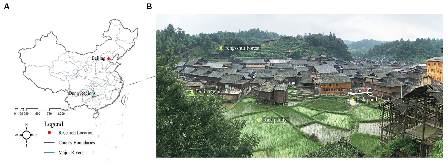
Figure 1. (A) The location and (B) the layout of Huanggang Dong Village, Liping County, Guizhou Province, China. The image was taken in July 2019.
2.2 Methods
The methods used in this study included site surveys, semi-structured interviews, participatory mapping, and prototype construction.
2.2.1 Site survey
After reviewing and analyzing the existing research literature and the writings of local scholars on the Huanggang village, we conducted two site surveys in Huanggang village in July 2019 and April 2020. During the site survey, the researchers collected information on the spatial distribution of forests, water systems, rice paddy fields, and buildings in Huanggang using 1:1,000 CAD topographic maps and drones, as well as manual labeling and mapping by the researchers.
2.2.2 Semi-structured interviews
The Dong people do not have their own writing, and they pass on their agricultural experiences and natural resource management methods through oral transmission. Semi-structured interviews have the flexibility to obtain information that the researchers may overlook. In this study, semi-structured interviews were conducted with 22 people, including the main managers, elders, and ordinary villagers, such as song masters, ghost masters, village secretary, the village head, farmers, workers, inn owners, and the former deputy director of the cultural and tourism bureau of the Liping County. The proportion of men and women was 63.7 and 36.3%, respectively; 50% of participants were aged 20–40, 36.4% were aged 40–60, and 13.6% were aged 60 and above. Since men aged 20 ~ 40 in Huanggang Dong Village often have the experience of going to other parts of China for work, they can generally speak the Chinese language. As a result of the absence of a language barrier, they accounted for a comparatively large proportion of interviewees. The interviews focused on the management of the rice-fish-duck system, and natural and ecological resource management and utilization. The interview questions were as follows.
1. How is the village forests managed?
2. How is the village water resources managed?
3. Have there been any natural disasters such as fires and floods in the village? How did you deal with it?
4. How is the village rice-fish-duck system managed?
5. How are the fish ponds, rice fields and vegetable plots in the village managed?
6. What poultry and livestock are there in the village and how are they managed?
7. How are the organic waste and garbage managed in the village?
8. What village rules have been established to protect the environment?
2.2.3 Participatory mapping
Participatory Geographic Information Systems (PGIS) emphasize community and public engagement. This approach involves local individuals in mapping places, converting cognitive spatial knowledge into cartographic and descriptive data. This enhances comprehension of the indigenous knowledge, practices, and beliefs within the community (Ramirez Gomez et al., 2013), thereby mitigating the limitations of expert-driven models (Van der Jagt et al., 2019). In our investigation, we scrutinized the PGIS methodologies proposed by Brown (2004), Ramirez Gomez et al. (2013), and Brown and Fagerholm (2015). We employed qualitative analysis for adapting to the specific context of the research site. After completing our fieldwork, we conducted participatory mapping in December 2021.
2.2.3.1 Participant selection and material preparation
In December 2021, we spent a month living with local villagers. During this time, we conducted random household surveys (Talen, 2000), engaged in interviews, and held project discussions with village officials and indigenous people, establishing close connections. Having developed a deep understanding of the village, we selected 40 participants with relatively comprehensive knowledge, spanning ages from 18 to 78. To conduct our mapping activities, we employed an intuitive paper map method, choosing satellite imagery with a spatial resolution of 0.5 meters obtained from Bigmap, covering various land use types such as village settlements and village forest areas. The maps were printed on A0-sized paper for mapping purposes.
2.2.3.2 Mapping process
We provided participants with basic training to ensure the accurate identification of maps, local landscape features, and familiarity with the mapping process (Damastuti and de Groot, 2019). We formulated guiding questions covering various forest boundaries, distribution and flow of water resources, distribution of paddy fields, vegetable plots, granaries, mother fish ponds, and fry fish ponds, as well as the locations of livestock breeding and firebreaks, and collection points for medicinal herbs, etc. Once the mapping activity started, participants were instructed to use red marker pens to mark single points or polygonal areas that met the criteria outlined in the guiding questions, numbering them sequentially (Figure 2). They then elaborated on how traditional livelihood practices and management were carried out in different geographical spaces. Finally, we summarized the data and constructed the EGI model for Huanggang Village.
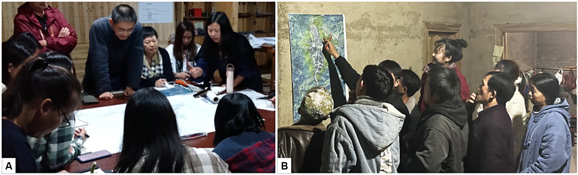
Figure 2. The mapping process with the participation of indigenous people: (A) Participation in the mapping process. (B) Process of semi-structured interview and participatory mapping.
3 Strategies of edible green infrastructure construction in traditional Chinese villages: the case of Huanggang Dong Village in mountainous southwest China
Based on theories related to EGI and eco-anthropological studies on traditional livelihood, this study proposes an EGI model of traditional Dong villages built on three aspects: core elements of traditional livelihoods, a hierarchical ecological structure and hierarchical management model. We hypothesize that this approach to EGI model construction may be universally applicable to traditional Chinese villages across different natural-geographical regions. The core element of traditional Dong livelihoods is the rice-fish-duck system, a well-established agricultural production model developed over thousands of years. The hierarchical EGI system includes EGI at the household-group-village level, which is the support and management system for local livelihoods and ecological security. The rice-fish-duck farming system and the hierarchical EGI system complement each other to support the survival and development of the village.
3.1 Strategy one: identifying the “rice-fish-duck” system as a key factor of traditional livelihoods adapted to local conditions
The traditional “rice-fish-duck” co-culture model is widespread in the Huanggang village. It is an important part of the artificial ecosystem of the village and a core element of its EGI system, as well as a major source of food for villagers (Figure 3). The following ecological knowledge is demonstrated by the model:
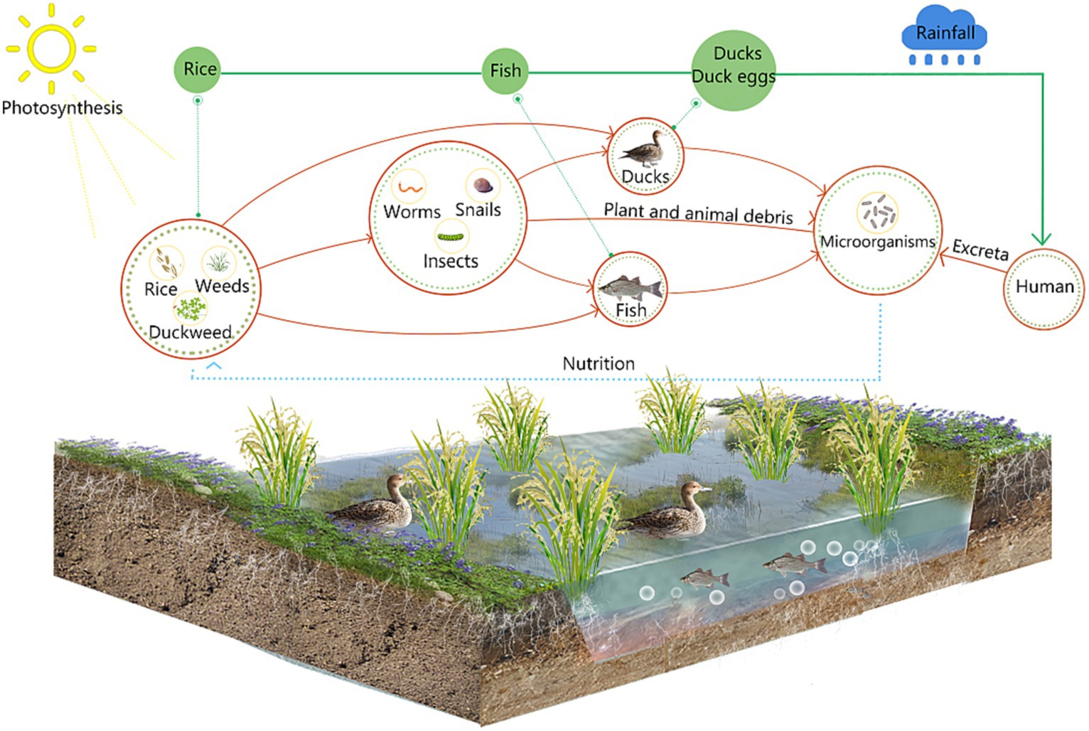
Figure 3. Illustration of the nutrient cycle of the rice-fish-duck system.
3.1.1 Nutrient cycling
The rice-fish-duck system creates a complete cycle of nutrients. The Dong people planted glutinous rice in paddy fields for sustenance and put in ducks and fish to be co-cultured with the glutinous rice. Ducks and fish promote water aeration by swimming in paddy fields and stimulate the tillering of the glutinous rice seedlings. The excrement of ducks and fish provides organic fertilizer for the paddy field, creating good conditions for the growth of glutinous rice. Falling grains and floating plants provide food for fish and ducks.
3.1.2 Pest and disease control in rice fields
In the rice-fish-duck rice paddy field system, the fish and ducks bump against the rice stalks during foraging, which may cause rice pests to fall into the water and become food for the fish and ducks. The ducks also consume some harmful invertebrates (e.g., shellfish and snails), effectively reducing pests and diseases in the rice field and ensuring the health of glutinous rice. Frequent disturbance by fish and ducks makes it difficult for weeds to set up, ensuring that glutinous rice has sufficient nutrients. The biological control effect of the rice-fish-duck system replaces the use of chemical fertilizers and pesticides (Lu and Li, 2006), preventing the pollution of soil and water resources, and allows a wide range of organisms to survive, providing a reliable zero-chemical fertilizer and zero-pesticide production model for contemporary agriculture.
3.1.3 Paddy management
According to the conditions of light, heat, water and soil of different paddy fields, the indigenous people have cultivated a variety of traditional tall straw glutinous rice cultivars adapted to specific habitats to ensure the yield of each paddy field. Glutinous rice with tall straw is more tolerant of waterlogging and can be adapted to deep-water rice fields where fish and ducks need to be kept, and enough space is reserved for ducks in the rice fields to move around. The simple fish shelters built with tree branches in the paddy fields provide fish with “shelter” from the hot sun and natural enemies. The ducks are native duck and sheldrake; the fish are carp and grass carp.
3.2 Strategy two: building a hierarchical ecological structure of households-groups-village
The EGI of three levels: household, group and village, is like the “leaf-branch-trunk” hierarchy of a tree, with each level being relatively independent and performing its own function, but closely related to ensure the efficient operation of the system. The household is the basic unit of the village, and its key functions are food production, nutrient circulation and pest control, just like the “leaf” of a tree, which gets sunlight, carbon dioxide and water from the outside world for photosynthesis and accumulation of nutrients. A group is made up of several families, which is an intermediate-level management unit bridging village and household. There are several ponds per group, the key function of which is rainwater collection and management and fire protection, just like the branches of a tree, which can form the tree skeleton and regulate the nutrition of the tree. The EGI at the village level includes a forest-water-field ecological structure, the key function of which is to ensure the organization of the water system and the reasonable distribution and management of the woods to give full play to their ecological efficacy, just like the “trunk” of a tree. The “trunk” of a tree is the basis for the growth of “branches” and “leaves,” and transports essential water and nutrients to the “branches” and “leaves” (Figure 4).
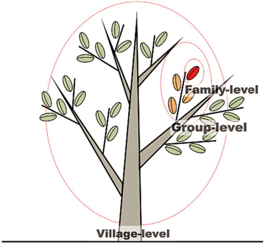
Figure 4. The “tree” structure of the EGI ecological network at the household-group-village level.
3.2.1 Ecological network at the household level
The EGI at the family level is built around the daily life of the Dong people. Family members need to master the whole set of eco-agroforestry management techniques necessary to operate the rice-duck-fish-vegetable-forest system. Food production, organic waste management and pest and disease control are the key issues to be solved in the management of EGI. The process of food production requires the application of large amounts of organic fertilizer, and households compost various kinds of domestic organic waste as much as possible, which is a necessary part of the operation of a stable artificial ecosystem, while the nutrient recycling system of the village forms a closed loop. The organic waste management in Huanggang village consists of two main forms: firstly, toilets are built on ponds used to rear the broodstock, to collect human feces and urine to form a fertile fish pond substrate; secondly, manure from livestock and poultry and plant materials are collected for composting and fermentation. Food production is a complex artificial ecosystem, rich in a variety of edible animal and plant materials, which guarantees a balanced diet, while taking advantage of the inter-biological constraints and controlling pests and diseases. This careful management of food production, organic waste and pests and diseases is a low-tech approach that effectively guarantees a sustainable supply of local living resources (Figure 5). Each family manages their own fish ponds, rice paddies, livestock and poultry, vegetable plots and woodlands, which provide them with subsistence resources such as food and timber (Figure 6).
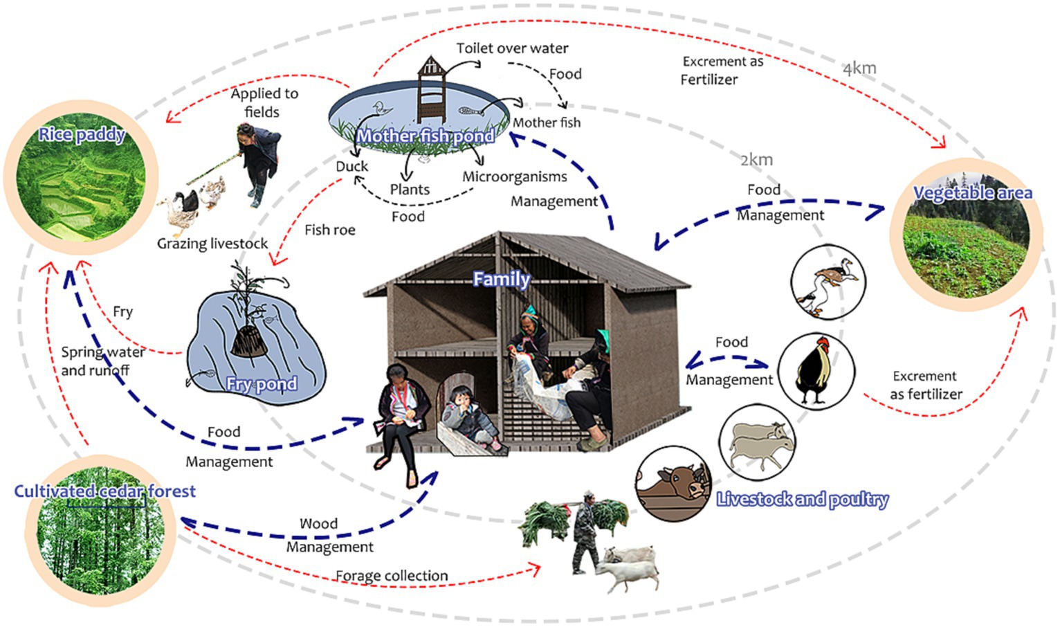
Figure 5. Schematic diagram of the EGI nutrient cycling and management at the household level.
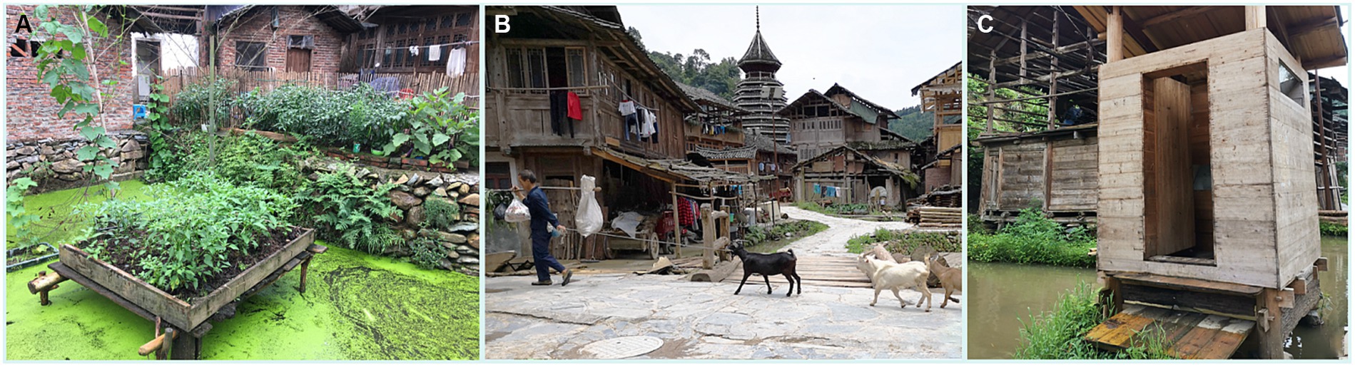
Figure 6. Examples of household EGI management: (A) Growing vegetables in the fish pond; (B) villagers grazing livestock; (C) a renovated “eco-toilet” in the mother fish pond.
3.2.1.1 Fish ponds
The fish ponds distributed in the village have the function of collecting rainwater and being used as fire barriers. There are two types of fish ponds: broodstock ponds and fish fry ponds. Broodstock ponds have four types of functions. (a) Breeding male and female fish for the production of fish roe. Female fish are only used for spawning, and villagers are explicitly prohibited from consuming fish from broodstock ponds. (b) As water toilets to directly collect villagers’ excrement to provide nutrition for fish and as organic fertilizer for vegetables and glutinous rice. (c) To grow vegetables and fruit for daily use of nearby residents using bamboo frames or planting troughs. (d) To cultivate plants such as Lemna minor Linn. and Trapa bispinosa Roxb. as livestock fodder. The fish fry ponds have two types of functions: to hatch fish fry and to grow vegetables. Fish pond management starts in April every year. In mid-April, the villagers place rattan strips in the mother fish pond, which adult fish use to attach the fertilized roe to; after the end of the spawning season, the rattan strips are lifted out of the water and placed into the fish fry pond with roe attached to them; thereby eventually populating the fish fry pond with roe.
3.2.1.2 Rice fields
Distributed on mountain slopes, hilltops, flatlands and next to forests, they are cultivation sites for glutinous rice and rice-fish-duck systems, and thus represent a staple food source for the villagers. The indigenous people have built rice fields in accordance with the topology, minimizing the ecological impact. They have selected and bred a variety of traditional glutinous rice varieties to adapt to different conditions of light, temperature, water and soil. The rice fields are planted in early May. Within a week after the rice seedlings are transplanted to the paddy field, the villagers relocate the newly hatched (<5 cm in total length) fry from the fish fry ponds into the paddy fields. A week later, the ducklings, which had not hatched more than 20 days earlier, are also placed in the paddy field. At this time, the glutinous rice has already established its roots, and the activities of the fish and ducks are not likely to cause damage to the growth of the glutinous rice, and the rice, fish and ducks can live together in the rice paddy.
3.2.1.3 Livestock and poultry
Livestock and poultry rearing pens are located downstream of village settlements or next to residential houses. They include chickens, ducks, pigs, cows and sheep, and provide a source of meat for villagers. The poultry and livestock rearing process disposes of a large amount of household food waste, makes efficient use of pasture and provides organic fertilizer for agricultural production, which in turn produces excess vegetables and fruits.
3.2.1.4 Vegetable patches
They are located in the hills and around the houses. The villagers plant different kinds of vegetables in different seasons according to the micro-environmental characteristics of each vegetable plot. For example, leeks are planted in the forest depressions where the environment is relatively moist; drought-tolerant varieties such as peanuts and peppers are planted on the dry slope tops where there is a lack of irrigation water; sweet potatoes, pumpkins and greens are planted on the hillside vegetable plots. Oilseed rape is planted in winter.
3.2.1.5 Woodlands
The cedar forests located on the outskirts of the village mainly provide wood for households, to use as building materials or for fuel. The indigenous people have planted cedar forests, which are carefully managed in a sustainable way.
3.2.2 Ecological network at the group level
Groups of households are centered around a fish pond. Each fish pond serves as a fire barrier, food production unit and rainwater storage. According to the geographical location and topographic features, the household groups comprising the Huanggang village can be divided into two categories: groups in residential areas and groups in the valley area at the edge of the village (Figure 7).
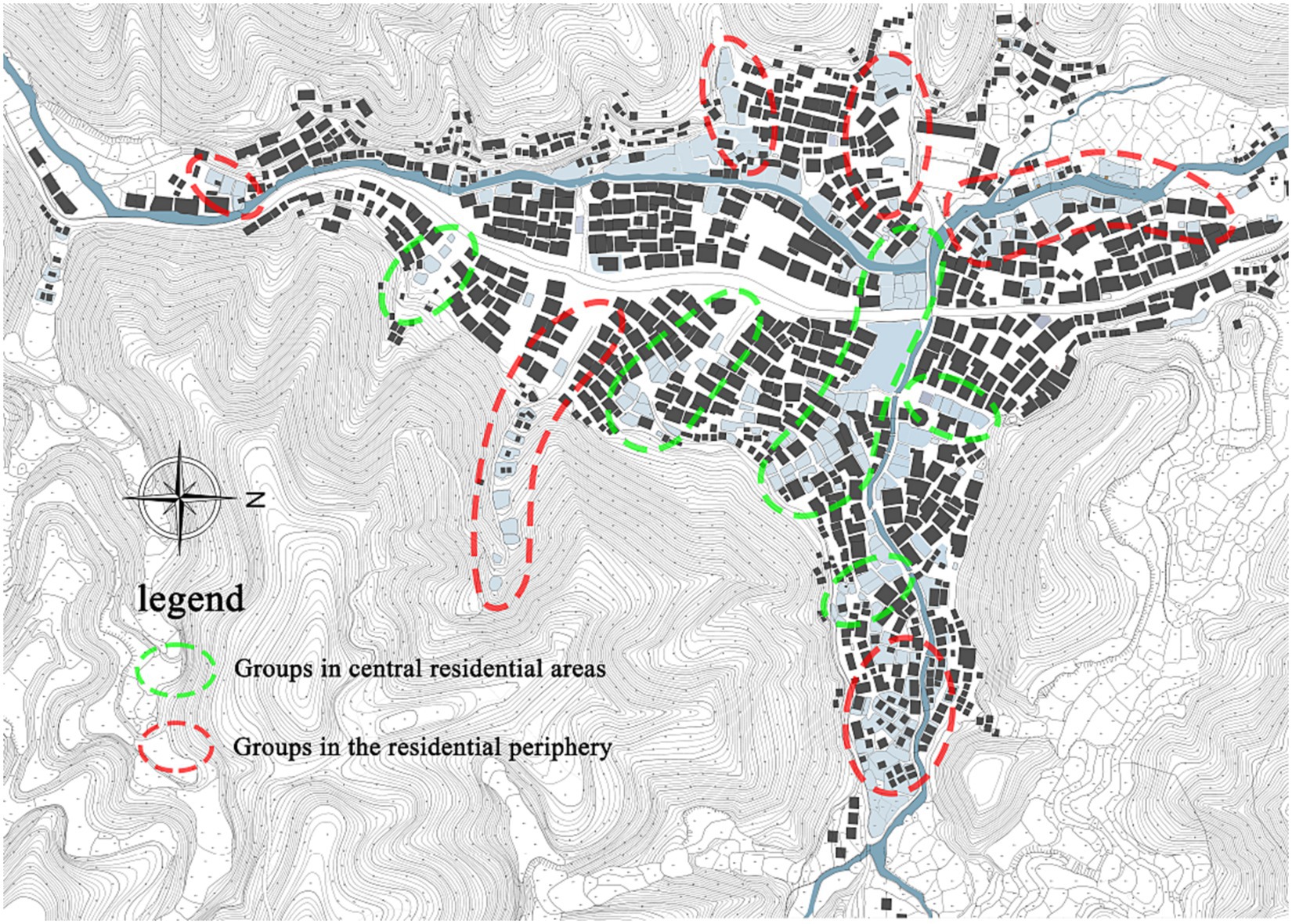
Figure 7. Spatial distribution of two types of EGI patterns at the group level.
3.2.2.1 Groups in central residential areas
Groups located in the central area of the village. Each group is a village unit linked by a fire protection belt about 20 m wide and shared by several families. The fire protection belt mainly consists of several fish ponds, and a fire protection pond, which is a square-shaped water storage pond built of stone masonry (Figure 8).
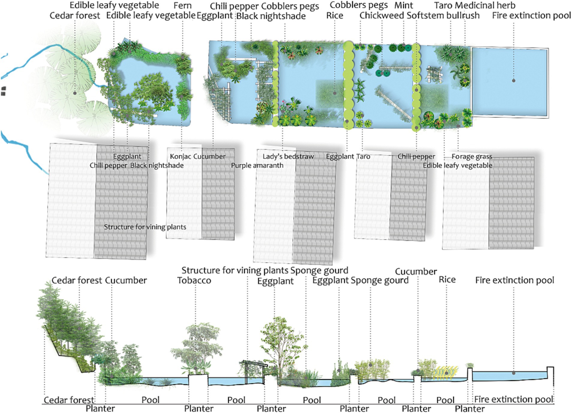
Figure 8. The spatial layout structure of EGI elements in residential areas.
The main function of these groups is fire isolation and rainwater storage, because all buildings in the village are constructed of wood. Once such houses are ignited, they can become a major safety issue for the whole village. The construction of a fire protection pond is thus a crucial safety element. A cooking stove is commonly built next to the fire protection pond for cooking and alcohol distillation. The fire protection pond also provides water for domestic use such as vegetable washing, etc. The fish ponds in the group are interconnected to form a group of small but biodiverse micro-wetlands. In addition to rearing fish and ducks, the fish ponds are also used to grow vegetables such as pepper, eggplant, taro, cucumber, konjac, loofah, and some wild herbs for daily use, such as Dicranopteris dichotoma (Thunb.) Bernh., Senecio scandens Buch. -Ham. ex D. Don., Solanum nigrum L., etc., and some wild plants such as ferns, fishy ferns, mint, reeds, etc., (Figure 9).
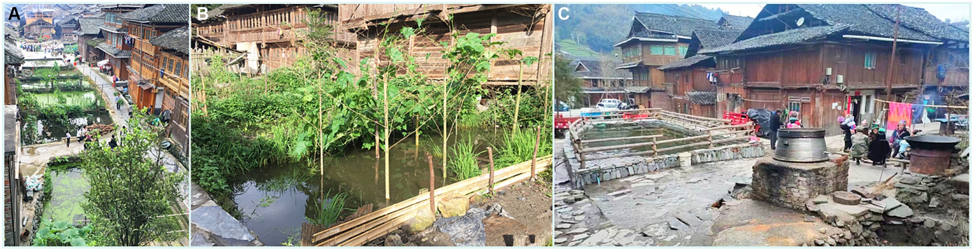
Figure 9. Examples of group EGI management: (A) Fish pond cluster; (B) plant diversity by the fish pond; (C) fire protection pond and cooking stove.
3.2.2.2 Groups in the residential periphery
Groups located at the edges of the village in the valley area or adjacent to forests. Each group comprises several fish ponds, often with altitude differences and interconnections (Figure 10).
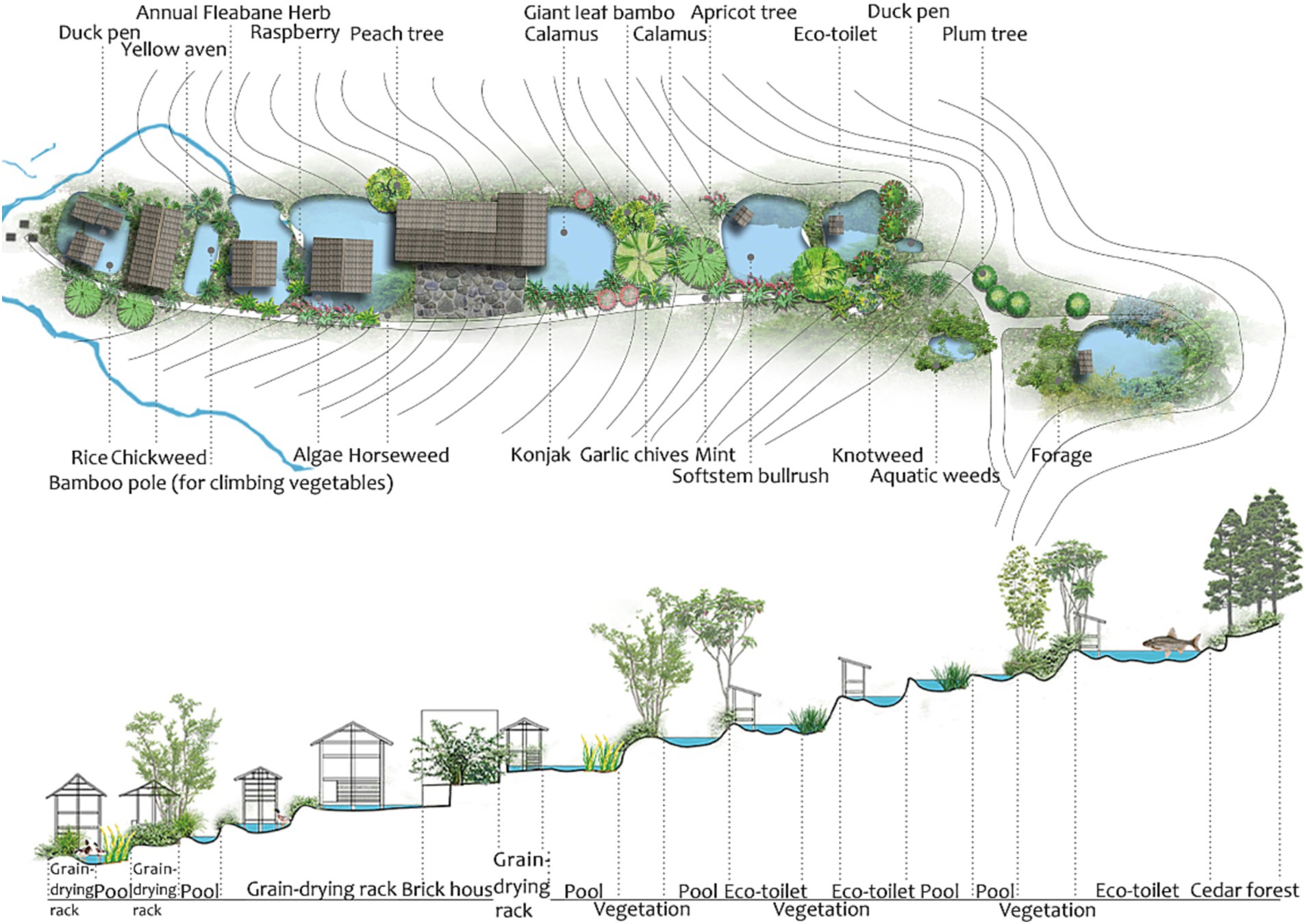
Figure 10. The spatial layout structure of EGI elements in the village edge group.
Due to their special geographical location and topographic conditions, these groups also assume the functions of rainwater retention and flash flood reduction. Rainwater runoff flows across the valley at the edge of the village, where it is detained and buffered by the fish ponds, reducing the risk of flooding in the village. Indigenous people have built grain-drying chambers on the fish ponds to avoid food loss due to the spread of fire and rodent infestation. Some vegetables and herbs are planted in the fish ponds, along the ridge of the ponds, and between the ponds. These include fishy grass, amaranth, loofah, pepper, wild coronary, rice, taro, Dicranopteris dichotoma (Thunb.) Bernh., etc. The residential houses and vegetable plots are scattered between these fish ponds (Figure 11).
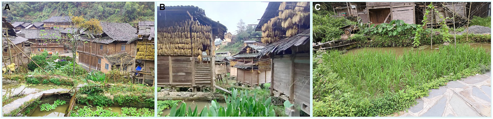
Figure 11. Examples of group EGI management: (A) Staggered fish pond clusters; (B) grain-drying chambers cluster on the periphery of the village; (C) plant diversity by the fish pond.
3.2.3 EGI at the village domain level
The traditional Dong livelihood model existing in the Huanggang village has built an EGI ecological network of “forest-water-field.” This system organically connects the forest and water system with food production to build the EGI framework of the village. As a sustainable food production system, it provides various livelihood resources (Figure 12).
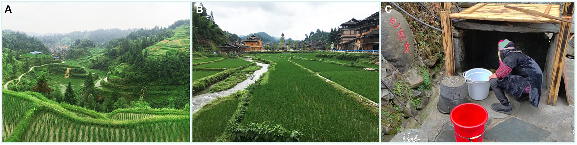
Figure 12. Village EGI landscapes: (A) “Forest-water-field” system in the village; (B) glutinous rice field; (C) ancient well in the village.
A wider forest-water-field system was constructed in the village area outside of the settlement managed by families and groups (Figure 13). The dense forest provides abundant water resources and reduces soil erosion. Streams, rice paddies, ponds and wells together form the water system of the village and create a richly structured wetland network. A large number of deep-water terraces built by villagers comprise a large interconnected water harvesting system, capable of storing large amounts of water. The entire forest-water-field ecological network system efficiently utilizes water resources (Figure 14), and maintains biodiversity and regional ecological stability. This system supports agricultural production in the Huanggang village and provides villagers with a large number of livelihood resources. These comprise food, such as fish, shrimp, celery, raspberries, and chestnuts; medicinal herbs include Artemisia argyi Levl. et Van., Paulownia fortunei (Seem.) Hemsl., Urtica fissa E. Pritz., Cornus officinalis Sieb. et Zucc., Aegilops sp. Linn., Cirsium japonicum Fisch. ex DC., etc.; the livestock fodder includes pastures; and finally there are herbal dyes such as indigo, etc.
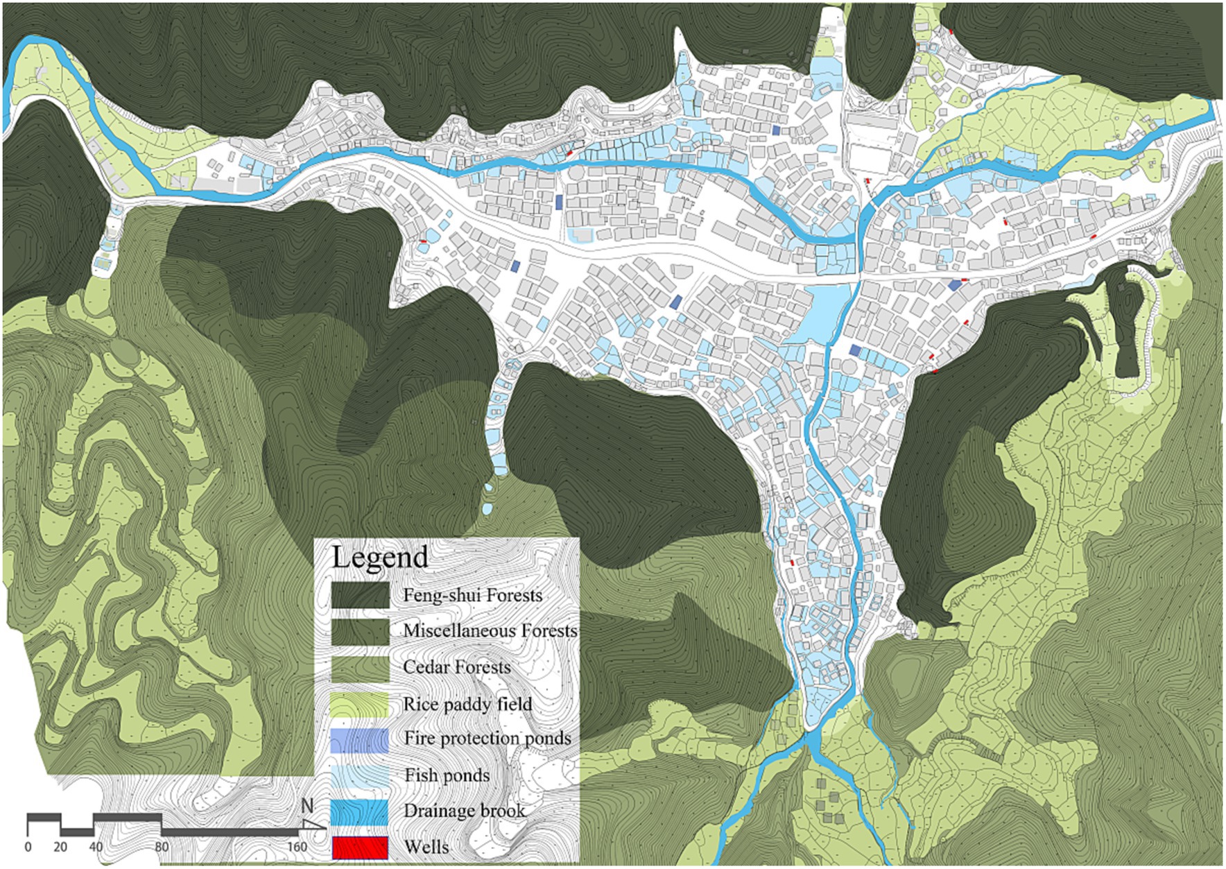
Figure 13. Spatial distribution of the forest-water-field ecological network in the village domain.
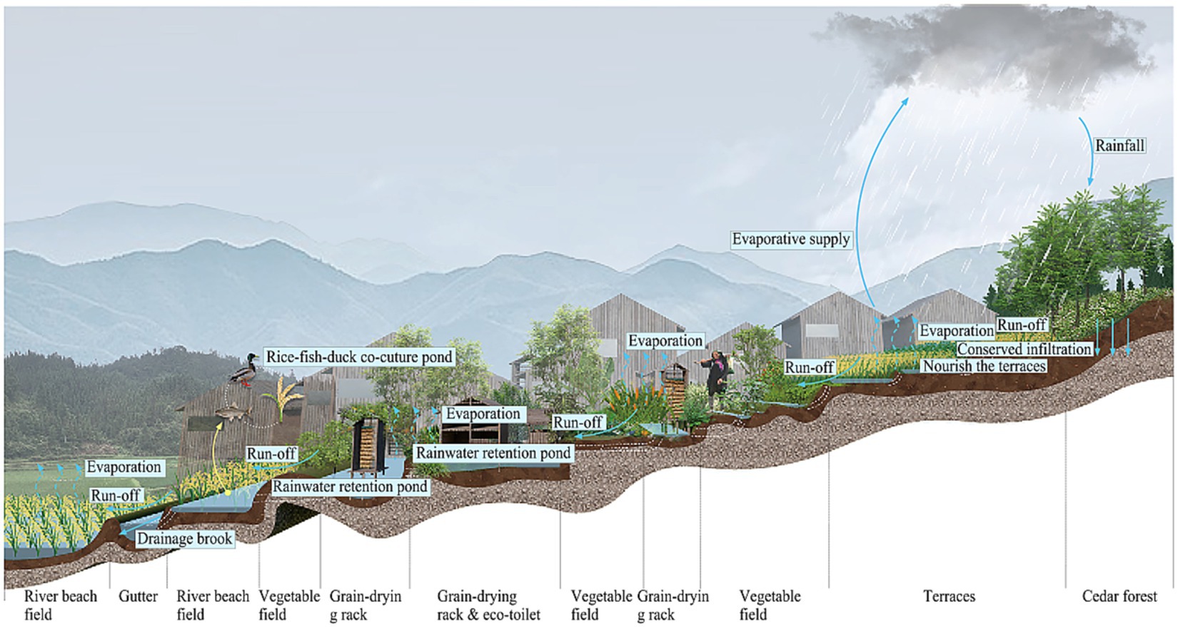
Figure 14. Spatial distribution and management of forest and water resources in the village.
3.2.3.1 Spatial distribution and management of forests
There are three types of forests in the Huanggang village: Fengshui Forest, miscellaneous woods, and cedar forest.
Fengshui Forest: Locally known as the Sacred Forest, is rooted in the traditional belief and practice system of Fengshui, originating in China. In this system, the flow of energy, referred to as ‘qi,’ is inextricably linked to flows of wind and water (Coggins et al., 2012). According to traditional Fengshui theory, ecologically sound conditions, such as fertile soil, fresh air, clean water, and vegetation, result from optimal spatial arrangement and connectivity aligned with Fengshui principles (Hong et al., 2007). Consequently, this theoretical approach is commonly employed in the geographical assessment of village site selection and orientation (Needham, 1974; Hong et al., 2007). Fengshui Forests serve various ecological functions, contributing to protecting biodiversity and conserving water sources. They are considered to have a significant impact on the physical and mental health, as well as prosperity of the local community (Guan, 2002). The Dong people revere forests, viewing them as the source of Fengshui. The local rules and regulations of Huanggang village stipulate that the woods within 500 meters distance from the village is Fengshui Forest that shelters the village and nobody is allowed to damage them. There are also “grave hills” belonging to each clan, which have existed for thousands of years and host a wealth of medicinal herbs. According to the census data of the Liping County Forestry Bureau in 2021, there are 79 surviving century-old trees in the Huanggang village. Villagers have the custom of worshipping certain trees as a “foster father” to bless the healthy growth of the child.
Miscellaneous woods: the secondary forests located on the periphery of the Fengshui Forest provide the village with a variety of resources needed for daily life. For example, bamboo has a wide range of applications in traditional households. Poplar, raspberry, and chestnut provide food sources. Medicinal herbs that grow in shaded spaces in the forest include Litsea pungens Hemsl., Dicranopteris dichotoma (Thunb.) Bernh., Blastus cochinchinensis Lour., Spatholobus suberectus Dunn., Deutzia scabra Thunb., Melastoma dodecandrum Lour., etc. Vegetables are grown next to the miscellaneous woods, as well as indigo, which is a common dye plant in the region.
Cedar forest: these are forests located at the periphery of miscellaneous woods, planted and managed by local villagers. The cedar forest produces construction material and fuelwood. When children are born, their parents plant cedar saplings in the cedar forest. After the children grow up, the adult cedar trees can be used to build new houses. The village has a tradition of “cutting one and planting ten,” which ensures the sustainable use of forest resources.
3.2.3.2 Spatial distribution and management of water resources
Streams, rice paddies, fish ponds and wells built in the villages provide water for food production, fire protection and villagers’ livelihoods; while creating a variety of biological habitats.
Streams: two streams, named Huanggang and Cenqiu, flow across the village from the east and south respectively, converge in the center of the village, and continue northward towards the Sizhai River. These streams are the main drainage channels of the village, and villagers sometimes enclose duck houses in the streams.
Rice fields: located on hillsides, hilltops, along flat streams and in forests, rice fields serve as water infrastructure for the rice-fish-duck system and as small reservoirs for collecting and storing rainwater, slowing down the runoff during the rainy season and storing water resources.
Fish ponds: mainly distributed on mountain slopes, in villages and by the streams. The core function of these fish ponds is to keep fish and for fire protection (fire barrier and a reservoir of water for fire protection). In addition, these interconnected ponds at different levels also assume the function of organizing the village water system and rainwater detention.
Wells: there are 11 wells in the Huanggang village, which provide the main source of water for drinking and cooking.
3.2.3.3 Spatial distribution and management of rice fields
Paddy fields are mainly located on slopes, hilltops, along streams, and in forests, and they are the main place where farming activities are carried out in the Huanggang village. The irrigation of paddy fields relies on rainwater and springs. The ponds or shallow grass strips in front of the paddy fields increase the temperature of the spring water entering the paddy fields.
3.3 Strategy three: building a corresponding hierarchical management model of households-groups-village centered on households
Village elders manage traditional Dong ethnic villages, with patrilineal kinship as the bond. Different clans are formed based on the degree of blood relationship, which establishes a stable social structure (Chen, 2012). The Dong people have a saying, “Old trees protect the village, and old people manage the village.” The villagers elect the most experienced and respected elders as “village elders” who are responsible for various village affairs and decision-making. However, this role is obligatory and does not entail privileges or social hierarchy (Luo, 2015). Village elders also participate in labor to obtain resources for their livelihood. Huanggang Dong Village consists of five “clans” that assist each other and jointly organize important production, construction, and ritual activities. Within families, members have relatively equal status, with the diminishing of paternal authority. The collaborative model of “men farming and women weaving, self-sufficiency” continues. Men primarily undertake strenuous physical labor such as farming, logging, and construction, while women mainly engage in household chores with lower labor intensity, including food preparation, weaving, managing vegetable plots, fish ponds, and raising poultry and livestock.
The EGI systems in traditional Dong villages are hierarchical ecological structures that take food production into account. At the household, group and village levels, EGI management is interlinked to ensure the efficient operation of the artificial EGI ecosystem. EGI at the household level is managed by members of a household, and includes the “rice-fish-duck” food production system, composting of human and animal waste, and management of cedar forests. EGI at the group level is jointly managed by households in the same group. Often, it is the different households within a clan, and mainly includes fire protection of wooden buildings, rainwater management, green space management and food production. EGI at the village level is collectively managed by all villagers, which construction, management and maintenance are organized by the leaders of the house clan, village elders, village chiefs, and includes the “forest-water-field” ecological structure.
Within the hierarchical EGI management model of traditional Dong villages, various actors are involved, resulting in a management system with reasonable division of labor and smooth coordination, ensuring the efficient operation of an EGI system that connects food production with ecological and environmental protection. Without such an intricate and effective hierarchical management model, the EGI system cannot perform its productive and ecological functions. Those in charge at all levels must have the knowledge and skills to manage this artificial ecosystem.
4 Implications of EGI construction strategies for rural bio-district construction
4.1 Lesson learned 1: identifying key agricultural species adapted to specific ecological and geographical conditions that can be organically integrated into EGI systems
Huanggang Dong Village has preserved to this day a relatively complete traditional livelihood model (“rice-fish-duck”). Relying on this model, the village has established EGI systems with key food production at their core. These systems have successfully addressed multiple challenges in the Dong region, such as limited arable land, landslides, and a humid climate with insufficient sunlight. The resource-constrained hilly topography has been transformed into a highly productive, water-rich ecosystem, ensuring a reliable supply of water and soil resources for the community. In different geo-ecological regions of the world, indigenous peoples have developed various traditional livelihood models adapted to local geo-climatic characteristics. An example is the Mulberry-Dike-Fish-Pond in southern China (Guo and Situ, 2010). These traditional livelihood models are good examples of sustainable natural resource management that center on key agricultural species and can be organically integrated into EGI systems.
4.2 Lesson learned 2: building a hierarchical ecological structure and hierarchical management model for sustainable agriculture
The EGI systems of traditional villages contain a households-groups-village hierarchy. An efficient hierarchical management model is formed in conjunction with rural grassroots organizations centered on households. The hierarchical ecological structure and hierarchical management model are the keys to EGI’s success, protecting natural resources, providing villagers with the food and other living resources they need, and mitigating the risk of disasters such as fire.
EGI management at the household level encompasses food production as a traditional livelihood, efficient management of organic waste and pest and disease control to detoxify the food system from harmful water fertilizer. EGI management at the group level includes public space management, rainwater collection and fire isolation to ensure order and safety in the village. EGI management at the village level includes the “forest-water-field” ecosystem, which provides a wide range of ecosystem services on a sound ecological basis. This hierarchical management model ensures grain yields and biodiversity. For example, fish ponds and open spaces around houses use a combination of farming practices for refined cultivation and increased yields. Well-adapted local breeds are developed with regard to the environmental features of each rice field and vegetable plot. At present, there are more than 20 varieties of glutinous rice preserved in Huanggang Dong Village. This well-adapted production method enhances the biodiversity of mountain agriculture to meet different environmental challenges and safeguard food production. Some varieties local to the region, such as “Daohua carp,” “Kam Sweet Rice” and “broadleaved leeks,” have the potential to contribute significantly to local farmers’ income. EGI systems in Huanggang Dong Village have created a multi-functional landscape, which plays an important role in protecting regional ecosystems, building sustainable food systems, and ensuring food security, thus confirming earlier research findings (Russo and Cirella, 2020).
4.3 Lesson learned 3: integrating environmental protection into agriculture and forestry management
The bio-district approach emphasizes practices that reduce the impact of agriculture on natural resources and the environment while building diverse landscapes. In their farming practices, without access to pesticides and chemical fertilizers, the indigenous people of Huanggang Dong Village demonstrate their commitment to environmental protection and fostering coexistence between humans and nature by adapting to local conditions. This is mainly achieved in the following ways: (1) The “rice-fish-duck” co-culture model provides biological control, which replaces the use of pesticides, ensures food safety and prevents water pollution. (2) The manure of poultry and livestock is collected to be used as organic fertilizer for rice fields and vegetable patches, which prevents environmental pollution and land degradation caused by chemical fertilizers. (3) The village has formulated regulations to protect forests. The commitment and tangible actions taken for environmental protection have ensured the sustainable development of agriculture and forestry in Huanggang Dong Village.
5 Conclusion
The emergence of bio-districts is perceived as an important opportunity for organic farming, especially in mountain areas with complex topographical and microclimatic features (Schermer, 2005). Bio-districts represent “an innovative approach for a sustainable, integrated and participatory territorial development” that builds around environmental, social and economic dimensions (Basile, 2018). Traditional villages across ecological and climatic regions of China have developed over millennia various EGI models that can protect the surrounding nature and biodiversity and foster balanced growth of agriculture and economy. These models contribute to environmental protection and have the potential for long-term endogenous development.
The value of this study is reflected in the following aspects:
1. This study introduces the concept of EGI and relevant theories of eco-anthropology. It proposes EGI construction strategies for traditional villages, encompassing the selection of key agricultural species, the establishment of multi-layered ecological networks, and corresponding management models. These strategies are presented within the framework of “ecological technology - spatial structure - management model.” Insights are drawn from the experience of mountainous rice farming in China to inform the creation of bio-districts. The EGI construction strategies can be applied to rural regions with a rich history of agricultural civilizations in various eco-climate regions, such as China, East Asia, Southeast Asia, South Asia, and even globally in southern regions. These strategies can assist researchers or decision-makers in systematically and conceptually understanding indigenous sustainable food systems and natural resource management wisdom rooted in local contexts, enabling their application to the development of rural bio-districts worldwide.
2. This study presents an innovative approach to local resource surveys for developing bio-districts. Semi-structured interviews and participatory mapping facilitate communication between experts and villagers, fostering a more comprehensive understanding of the traditional livelihoods and ecological wisdom rooted in villages over centuries. This benefits various stakeholders by protecting rural traditions and culture, preserves the emotional ties of villagers, and supporting policymakers at both the local and national levels in planning the development of bio-districts and formulating relevant policies in a more humane manner.
3. This study contributes to enhancing cultural diversity and attractiveness in traditional villages, bringing about development and economic benefits to the region.
The limitations and prospects of this study are as follows:
1. Conduct case studies on traditional villages in diverse eco-climate regions, such as those formed by dry agriculture on the Loess Plateau and traditional villages in the waterlogged rice cultivation regions of the middle and lower reaches of the Yangtze River. This expansion will provide a more comprehensive understanding of EGI construction strategies in traditional Chinese villages, offering more cases and multidimensional insights into sustainable local food systems and the development of bio-districts.
2. Based on research findings on EGI in traditional Chinese villages, drive the construction and development of bio-districts by promoting understanding and utilization of local resources.
Due to its geographical isolation, Huanggang Dong Village has not fully tapped its rural organic branding to raise the economic value of its products, putting the local industry at a disadvantage. Looking to the successes of European bio-districts, the village could work with various actors such as associations, and eco-tourism operators, and build its own brand in organic farming and marketing channels both within the region and outside of it, in order to revitalize the region’s economy. For traditional Chinese villages, it is critical to establish organic regions on the basis of existing traditional farming practices and valuable experiences in natural management (Knickel and Peter, 2004). This could create new jobs for vulnerable groups, protect the health of farmers and consumers, help to preserve cultural traditions, foster social cohesion, and boost local economic growth (Groier, 2008).
Data availability statement
The original contributions presented in the study are included in the article/supplementary material, further inquiries can be directed to the corresponding author.
Ethics statement
Written informed consent was obtained from the individual(s) for the publication of any potentially identifiable images or data included in this article.
Author contributions
CZ: Methodology, Software, Investigation, Data curation, Writing - original draft preparation. DW: Writing—review and editing. JL: Methodology, Investigation, Data curation, Writing—review and editing, Project Administration, Funding Acquisition. All authors contributed to the article and approved the submitted version.
Funding
The author(s) declare financial support was received for the research, authorship, and/or publication of this article. This research was supported by grants from the National Natural Science Foundation of China (No. 32001365).
Acknowledgments
The authors would like to thank Di Wu and Chunli Shen for their contributions to the photographs in Figure 2, Lu Yan for her contribution to Figure 3, Shiqi Yang for her contribution to Figure 4, and Yurui Feng for her contribution to Figure 5.
Conflict of interest
The authors declare that the research was conducted in the absence of any commercial or financial relationships that could be construed as a potential conflict of interest.
Publisher’s note
All claims expressed in this article are solely those of the authors and do not necessarily represent those of their affiliated organizations, or those of the publisher, the editors and the reviewers. Any product that may be evaluated in this article, or claim that may be made by its manufacturer, is not guaranteed or endorsed by the publisher.
References
Agnoletti, M. (2014). Rural landscape, nature conservation and culture: some notes on research trends and management approaches from a (southern) European perspective. Landsc. Urban Plan. 126, 66–73. doi: 10.1016/j.landurbplan.2014.02.012
Alexandra, J., and Riddington, C. (2007). Redreaming the rural landscape. Futures 39, 324–339. doi: 10.1016/j.futures.2006.04.002
Basnou, C., Baró, F., Langemeyer, J., Castell, C., Dalmases, C., and Pino, J. (2020). Advancing the green infrastructure approach in the province of Barcelona: integrating biodiversity, ecosystem functions and services into landscape planning. Urban For. Urban Green. 55:126797. doi: 10.1016/j.ufug.2020.126797
Benedict, M. A., and McMahon, E. T. (2012). Green Infrastructure: Linking Landscapes and Communities. Washington, DC, US: Island Press.
Betts, M. G., Yang, Z., Hadley, A. S., Smith, A. C., Rousseau, J. S., Northrup, J. M., et al. (2022). Forest degradation drives widespread avian habitat and population declines. Nat. Ecol. Evol. 6, 709–719. doi: 10.21203/rs.3.rs-686817/v1
Brown, G. (2004). Mapping spatial attributes in survey research for natural resource management: methods and applications. Soc. Nat. Resour. 18, 17–39. doi: 10.1080/08941920590881853
Brown, G., and Fagerholm, N. (2015). Empirical PPGIS/PGIS mapping of ecosystem services: a review and evaluation. Ecosyst. Serv. 13, 119–133. doi: 10.1016/j.ecoser.2014.10.007
Chatzimentor, A., Apostolopoulou, E., and Mazaris, A. D. (2020). A review of green infrastructure research in Europe: challenges and opportunities. Landsc. Urban Plan. 198:103775. doi: 10.1016/j.landurbplan.2020.103775
Chen, Y. (2012). Philosophical Dong Culture. Xicheng District, Beijing, China: China Forestry Publishing House.
Chen, X. L., and Deng, M. W. (2014). Study on the Ecological Culture of Dong People in China. Xicheng District, Beijing, China: China Forestry Publishing House.
China, N.B.o.S.o. (2021). China Statistical Yearbook. Xicheng District, Beijing, China: China Statistics Press.
Clapp, J., and Moseley, W. G. (2020). This food crisis is different: COVID-19 and the fragility of the neoliberal food security order. J. Peasant Stud. 47, 1393–1417. doi: 10.1080/03066150.2020.1823838
Coggins, C., Chevrier, J., Dwyer, M., Longway, L., Xu, M., Tiso, P., et al. (2012). Village fengshui forests of southern China–culture history and conservation status. ASIANetwork Exch. J. Asian Stud. Liberal Arts 19, 52–67. doi: 10.16995/ane.43
Coutts, C., and Hahn, M. (2015). Green infrastructure, ecosystem services, and human health. Int. J. Environ. Res. Public Health 12, 9768–9798. doi: 10.3390/ijerph120809768
Crist, E., Mora, C., and Engelman, R. (2017). The interaction of human population, food production, and biodiversity protection. Science 356, 260–264. doi: 10.1126/science.aal2011
Cui, H. Y. (2007). Reconceptualizing the ecological value of dong traditional livelihood practices: an example of glutinous Rice cultivation and water storage of the dong people in Huanggang. Think. China 33, 135–136. doi: 10.3969/j.issn.1001-778X.2007.06.029
Cui, H. Y. (2009). People and Rice Fields: A Study of Traditional Livelihoods of the Dong People in Huanggang, Liping, Guizhou. Kunming, Yunnan, China: Yunnan People’s Publishing House.
Cui, H. Y. (2015). Dong Traditional Farming Culture and Water Security in the Pearl River Basin. Haidian District, Beijing, China: Intellectual Property Publishing House.
Damastuti, E., and de Groot, R. (2019). Participatory ecosystem service mapping to enhance community-based mangrove rehabilitation and management in Demak, Indonesia. Reg. Environ. Chang. 19, 65–78. doi: 10.1007/s10113-018-1378-7
Dara Guccione, G., and Sturla, A. (2021). Approccio Agroecologico e Biodistretti, Analisi di due Casi Studio. Rome, Italy: SINAB (Sistema di Informazione Nazionale sull’Agricoltura Biologica).
Davies, C., and Lafortezza, R. (2017). Urban green infrastructure in Europe: is greenspace planning and policy compliant? Land Use Policy 69, 93–101. doi: 10.1016/j.landusepol.2017.08.018
Dias, R. S., Costa, D. V., Correia, H. E., and Costa, C. A. (2021). Building bio-districts or eco-regions: participative processes supported by focal groups. Agriculture 11:511. doi: 10.3390/agriculture11060511
Du Toit, M. J., Cilliers, S. S., Dallimer, M., Goddard, M., Guenat, S., and Cornelius, S. F. (2018). Urban green infrastructure and ecosystem services in sub-Saharan Africa. Landsc. Urban Plan. 180, 249–261. doi: 10.1016/j.landurbplan.2018.06.001
Eilola, S., Käyhkö, N., Ferdinands, A., and Fagerholm, N. (2019). A bird’s eye view of my village–developing participatory geospatial methodology for local level land use planning in the southern highlands of Tanzania. Landsc. Urban Plan. 190:103596. doi: 10.1016/j.landurbplan.2019.103596
Escobedo, F. J., Giannico, V., Jim, C. Y., Sanesi, G., and Lafortezza, R. (2019). Urban forests, ecosystem services, green infrastructure and nature-based solutions: Nexus or evolving metaphors? Urban For. Urban Green. 37, 3–12. doi: 10.1016/j.ufug.2018.02.011
FAO (2018). Transforming Food and Agriculture to Achieve the SDGs: 20 Interconnected Actions to Guide Decision-Makers. Rome, Italy: FAO.
Ferreira, J. C., Monteiro, R., and Silva, V. R. (2021). Planning a green infrastructure network from theory to practice: the case study of Setúbal, Portugal. Sustainability 13:8432. doi: 10.3390/su13158432
Francis, C., Lieblein, G., Gliessman, S., Breland, T. A., Creamer, N., Harwood, R., et al. (2003). Agroecology: the ecology of food systems. J. Sustain. Agric. 22, 99–118. doi: 10.1300/j064v22n03_10
Galanakis, C. M. (2020). The food systems in the era of the coronavirus (COVID-19) pandemic crisis. Foods 9:523. doi: 10.3390/foods9040523
Gimona, A., and van der Horst, D. (2007). Mapping hotspots of multiple landscape functions: a case study on farmland afforestation in Scotland. Landsc. Ecol. 22, 1255–1264. doi: 10.1007/s10980-007-9105-7
Groier, M. (2008). Auf dem Weg zur Bioregion: Ergebnisse, Erfahrungen und Reflexionen aus Einem Aktionsforschungsprojekt. Wien, Österreich: Bundesanst. für Bergbauernfragen.
Guan, C. (2002). Investigation on geomantic forest in ancient China. Agric. Archaeol. 3, 239–243. doi: 10.3969/j.issn.1006-2335.2002.03.032
Guo, S. H., and Situ, S. J. (2010). The value and utilization of mulberry-dike-fish-pond in the Pearl River Delta in perspective of the agricultural heritage. Trop. Geogr. 30, 452–458. doi: 10.3969/j.issn.1001-5221.2010.04.021
Hammer, T., Mose, I., Siegrist, D., and Weixlbaumer, N. (2016). Parks of the Future: Protected areas in Europe Challenging Regional and Global Change. Germany: Oekom Verlag.
Herath, H., Halwatura, R., and Jayasinghe, G. (2018). Evaluation of green infrastructure effects on tropical Sri Lankan urban context as an urban heat island adaptation strategy. Urban For. Urban Green. 29, 212–222. doi: 10.1016/J.UFUG.2017.11.013
Hinrichs, C. C., and Lyson, T. A. (2007). Remaking the North American Food System: Strategies for Sustainability. U of Nebraska Press.
Hong, S.-K., Song, I.-J., and Wu, J. (2007). Fengshui theory in urban landscape planning. Urban Ecosyst. 10, 221–237. doi: 10.1007/s11252-006-3263-2
Hu, Y., Chen, S., Cao, W., and Cao, C. Z. (2014). The concept and cultural connotation of traditional villages. Urban Dev. Stud. 21, 10–13. doi: 10.3969/j.issn.1006-3862.2014.01.021
Jian, X., Xue, W., Tang, J. J., Zhang, J. E., Luo, S. M., and Xin, C. (2011). Conservation of traditional rice varieties in a globally important agricultural heritage system (GIAHS): Rice-fish co-culture. Agric. Sci. China 10, 754–761. doi: 10.1016/S1671-2927(11)60059-X
Kavehei, E., Jenkins, G., Adame, M., and Lemckert, C. (2018). Carbon sequestration potential for mitigating the carbon footprint of green stormwater infrastructure. Renew. Sust. Energ. Rev. 94, 1179–1191. doi: 10.1016/j.rser.2018.07.002
Knickel, K., and Peter, S. (2004). Rural areas are shaping the future: some experiences with the regional action programme in Germany. Farming Rural Syst. Res. Ext., 595–604.
Köck, G., Umhack, M., and Diry, C. (2013). The Austrian biosphere reserves. A (connoisseur’s) world beyond the cookery book. Eco. Mont 5, 59–63. doi: 10.1553/ecomont-5-2s59
Koohafkan, P., and Altieri, M. A. (2011). Globally Important Agricultural Heritage Systems: A Legacy for the Future. Washington D.C, US: Food and Agriculture Organization of the United Nations Rome.
La Rosa, D., and Privitera, R. (2013). Characterization of non-urbanized areas for land-use planning of agricultural and green infrastructure in urban contexts. Landsc. Urban Plan. 109, 94–106. doi: 10.1016/j.landurbplan.2012.05.012
Lennon, M., and Scott, M. (2014). Delivering ecosystems services via spatial planning: reviewing the possibilities and implications of a green infrastructure approach. Town Plan. Rev. 5, 367–377. doi: 10.1080/14616680309714
Lipsky, Z. (1995). The changing face of the Czech rural landscape. Landsc. Urban Plan. 31, 39–45. doi: 10.1016/0169-2046(94)01034-6
Liu, J. J., Li, B. F., Ning, Y. F., and Born, B. (2013). A research on American food system planning. Urban Plan. Int. 28, 103–108.
Liu, J. J., Li, B. F., Rottle, N., and Ning, Y. F. (2012). Constructing life support system in urbanized area: a case study of urban green infrastructure in Seattle. Chin. Landsc. Arch. 3, 116–120. doi: 10.3969/j.issn.1000-6664.2012.03.024
Lu, J. B., and Li, X. (2006). Review of rice–fish-farming systems in China — one of the globally important ingenious agricultural heritage systems (GIAHS). Aquaculture 260, 106–113. doi: 10.1016/j.aquaculture.2006.05.059
Luo, K. L. (2009). A cultural interpretation of dong traditional livelihood practices and ecological security. Think. China 35, 11–16. doi: 10.3969/j.issn.1001-778X.2009.02.003
Luo, K. Z. (2011). The rice, fish and duck symbiosis model in the beautiful survival of the dong people – a case study of the Huanggang dong people in Liping, Guizhou. J. Hubei Minzu Univ. Philos. Soc. Sci. 29, 28–32. doi: 10.3969/j.issn.1004-941X.2011.01.005
Luo, K. Z. (2015). The constraints of spatiotemporal rules on the construction of harmonious communities: reflections from a social structure survey in Huanggang Dong Village. J. Qiannan Normal Coll. Nationalities 35:7. doi: 10.3969/j.issn.1674-2389.2015.02.003
Ma, G. J. (2009). Economic development and ecological adaptation——the changes of ethnic groups in Yun-Gui plateau during the three major historical periods as an example. Guizhou Ethnic Stud. 29, 127–132.
Matricardi, E. A. T., Skole, D. L., Costa, O. B., Pedlowski, M. A., Samek, J. H., and Miguel, E. P. (2020). Long-term forest degradation surpasses deforestation in the Brazilian Amazon. Science 369, 1378–1382. doi: 10.1126/science.abb3021
Matthews, T., Lo, A. Y., and Byrne, J. A. (2015). Reconceptualizing green infrastructure for climate change adaptation: barriers to adoption and drivers for uptake by spatial planners. Landsc. Urban Plan. 138, 155–163. doi: 10.1016/j.landurbplan.2015.02.010
McLain, R., Poe, M., Hurley, P. T., Lecompte-Mastenbrook, J., and Emery, M. R. (2012). Producing edible landscapes in Seattle’s urban forest. Urban For. Urban Green. 11, 187–194. doi: 10.1016/j.ufug.2011.12.002
Meerow, S., and Newell, J. P. (2017). Spatial planning for multifunctional green infrastructure: growing resilience in Detroit. Landsc. Urban Plan. 159, 62–75. doi: 10.1016/j.landurbplan.2016.10.005
Newman, G., Sansom, G. T., Yu, S., Kirsch, K. R., Li, D., Kim, Y., et al. (2022). A framework for evaluating the effects of green infrastructure in mitigating pollutant transferal and flood events in Sunnyside, Houston, TX. Sustainability 14:4247. doi: 10.3390/su14074247
OEP (2019). What are Local and Sustainable Food Systems (LSFSs). Osservatorio Europeo del Paesaggio.
Pu, K., and Long, Y. X. (2012). Dong women and the conservation of in situ transmission of Xianghe glutinous rice genetic resources: a field case study from Huanggang Dong Village, Liping, Guizhou. J. Southwest Minzu Univ. Hum. Soc. Sci. 33, 28–35.
Ramirez Gomez, S. O., Brown, G., and Fat, A. T. S. (2013). Participatory mapping with indigenous communities for conservation: challenges and lessons from Suriname. Electron. J. Inf. Syst. Dev. Count. 58, 1–22. doi: 10.1002/j.1681-4835.2013.tb00409.x
Russo, A., and Cirella, G. T. (2020). Edible green infrastructure for urban regeneration and food security: case studies from the Campania region. Agriculture 10:358. doi: 10.3390/agriculture10080358
Russo, A., Escobedo, F. J., Cirella, G. T., and Zerbe, S. (2017). Edible green infrastructure: an approach and review of provisioning ecosystem services and disservices in urban environments. Agric. Ecosyst. Environ. 242, 53–66. doi: 10.1016/j.agee.2017.03.026
Schermer, M. (2005). The impact of eco-regions in Austria on sustainable rural livelihoods. Int. J. Agric. Sustain. 3, 92–101. doi: 10.1080/14735903.2005.9684747
Seiwert, A., and Rößler, S. (2020). Understanding the term green infrastructure: origins, rationales, semantic content and purposes as well as its relevance for application in spatial planning. Land Use Policy 97:104785. doi: 10.1016/j.landusepol.2020.104785
Shao, H., Kim, G., Li, Q., and Newman, G. (2021). Web of science-based green infrastructure: a bibliometric analysis in citespace. Land 10:711. doi: 10.3390/land10070711
Shi, Y., Zhang, Y., Wu, B., Wang, B., Li, L., Shi, H., et al. (2022). Building social resilience in North Korea can mitigate the impacts of climate change on food security. Nat. Food 3, 499–511. doi: 10.1038/s43016-022-00551-6
Shimpo, N., Wesener, A., and McWilliam, W. (2019). How community gardens may contribute to community resilience following an earthquake. Urban For. Urban Green. 38, 124–132. doi: 10.1016/j.ufug.2018.12.002
Stotten, R., Bui, S., Pugliese, P., Schermer, M., and Lamine, C. (2018). Organic values-based supply chains as a tool for territorial development: a comparative analysis of three European organic regions. Int. J. Sociol. Agric. Food 24, 135–154. doi: 10.48416/IJSAF.V24I1.120
Stotten, R., and Froning, P. (2023). Territorial rural development strategies based on organic agriculture: the example of Valposchiavo, Switzerland. Front. Sustain. Food Syst. 7:1182993. doi: 10.3389/fsufs.2023.1182993
Talen, E. (2000). Bottom-up GIS: a new tool for individual and group expression in participatory planning. J. Am. Plan. Assoc. 66, 279–294. doi: 10.1080/01944360008976107
Vallecillo, S., Polce, C., Barbosa, A., Perpiña Castillo, C., Vandecasteele, I., Rusch, G. M., et al. (2018). Spatial alternatives for green infrastructure planning across the EU: an ecosystem service perspective. Landsc. Urban Plan. 174, 41–54. doi: 10.1016/j.landurbplan.2018.03.001
van der Jagt, A. P. N., Smith, M., Ambrose-Oji, B., Konijnendijk, C. C., Giannico, V., Haase, D., et al. (2019). Co-creating urban green infrastructure connecting people and nature: a guiding framework and approach. J. Environ. Manag. 233, 757–767. doi: 10.1016/j.jenvman.2018.09.083
Wang, J. (2019). Study on the development mechanism of traditional livelihoods in the southwest. Soc. Sci. Yunnan 1, 114–121.
Wang, N., Fang, M., Beauchamp, M., Jia, Z., and Zhou, Z. (2021). An indigenous knowledge-based sustainable landscape for mountain villages: the Jiabang rice terraces of Guizhou, China. Habitat Int. 111:102360. doi: 10.1016/j.habitatint.2021.102360
Weber, T., Sloan, A., and Wolf, J. (2006). Maryland’s green infrastructure assessment: development of a comprehensive approach to land conservation. Landsc. Urban Plan. 77, 94–110. doi: 10.1016/j.landurbplan.2005.02.002
Wild, T., Henneberry, J., and Gill, L. (2017). Comprehending the multiple ‘values’ of green infrastructure–valuing nature-based solutions for urban water management from multiple perspectives. Environ. Res. 158, 179–187. doi: 10.1016/j.envres.2017.05.043
Wu, P. (2014). Globally important agricultural cultural heritage: Rice, fish and duck complex system. J. Ethnic Culture 6:2.
Xie, J., Hu, L., Tang, J., Wu, X., Li, N., Yuan, Y., et al. (2011). Ecological mechanisms underlying the sustainability of the agricultural heritage rice–fish coculture system. Proc. Natl. Acad. Sci. 108, E1381–E1387. doi: 10.1073/pnas.1111043108
Xie, H., Zhang, Y., Wu, Z., and Lv, T. (2020). A bibliometric analysis on land degradation: current status, development, and future directions. Land 9:28. doi: 10.3390/land9010028
Yacamán Ochoa, C., Ferrer Jiménez, D., and Mata Olmo, R. (2020). Green infrastructure planning in metropolitan regions to improve the connectivity of agricultural landscapes and food security. Land 9:414. doi: 10.3390/land9110414
Yang, T. S., and Luo, K. L. (2012). Beautiful Survival - Guizhou. Guiyang, Guizhou, China: Guizhou People’s Press.
Yang, T. S., and Lv, Y. F. (2004). The Roots of Humanity: Soil and Water Resources in the Perspective of Ecological Anthropology. Kunming, Yunnan Province, China: Yunnan University Press.
Yang, T. S., and Yang, Z. H. (2015). Establishing a correct view of “cultural ecology” is the foundation of ecological civilization construction. Think. China 41, 100–115.
Yin, S. T. (2013). An anthropological view of ecological civilization. J. South Cent. Minzu Univ. Hum. Soc. Sci. 33, 44–49. doi: 10.3969/j.issn.1672-433X.2013.02.009
Zhai, H. M. (2017). The exploration of “culture-ecology” and its value in ecological civilization construction in the perspective of eco-anthropology. J. Minzu Univ. China Philos. Soc. Sci. Ed. 44, 78–84. doi: 10.15970/j.cnki.1005-8575.2017.01.010
Zhang, M. (1985). “Dong descended from Liao” – a challenge, and origin and migration of the dong. Guizhou Ethnic Stud. 4, 1–14.
Keywords: bio-district, traditional villages, traditional livelihoods, edible green infrastructure, green infrastructure (GI), indigenous knowledge
Citation: Zi C, Winterbottom D and Liu J (2024) Strategies for building edible green infrastructure in traditional villages and insights into bio-districts: a case study of Dong villages in Huanggang, China. Front. Sustain. Food Syst. 8:1305094. doi: 10.3389/fsufs.2024.1305094
Edited by:
Carola Strassner, Münster University of Applied Sciences, GermanyReviewed by:
Thomas Panagopoulos, University of Algarve, PortugalCesare Zanasi, University of Bologna, Italy
Copyright © 2024 Zi, Winterbottom and Liu. This is an open-access article distributed under the terms of the Creative Commons Attribution License (CC BY). The use, distribution or reproduction in other forums is permitted, provided the original author(s) and the copyright owner(s) are credited and that the original publication in this journal is cited, in accordance with accepted academic practice. No use, distribution or reproduction is permitted which does not comply with these terms.
*Correspondence: Juanjuan Liu, bGl1anVhbmp1YW5Ac3dmdS5lZHUuY24=