 Valentino Giorgio Rettore
 Daniele Codato
 Massimo De Marchi
- 1Advanced Master in GIScience and Unmanned Systems for the Integrated Management of the Territory and Natural Resources, University of Padua, Padua, Italy
- 2Department of Civil, Environmental and Architectural Engineering, University of Padua, Padua, Italy
Agrobiodiversity plays a critical role in fostering the stability, resilience, and sustainability of European farming systems. Nonetheless, there is currently a lack of comprehensive methods to describe its spatial distribution within farms, its connectivity with the surrounding landscape, and, most crucially, how the perceptions and actions of human communities affect it. The Main Agroecological Structure (MAS) has recently been proposed as an environmental index aiming to tackle such challenges by promoting a dialogue between landscape ecology and agroecology, encompassing criteria that focus on both landscape parameters and cultural variables. Geographic information systems (GIS) can play a key role in the measurement of the index by leveraging public geodata and engaging with the direct participation of communities to map the territories they inhabit and cultivate. Nevertheless, their use in this context has not yet been studied. We propose here a new GIS-based approach for estimating the Main Agroecological Structure: landscape criteria are assessed through the hybrid use of free and open-source GIS tools, field samplings, and participative mapping methods; cultural parameters are evaluated through semi-structured interviews. Contextually to the definition of such methodological foundations, the present study tests the relevance of the index to European agroecological contexts by applying the proposed workflow to three Italian farms characterized by different territorial and organizational forms. Along with a few modifications to the original proposal, we highlight the relevance of GIS in making agrobiodiversity visible at a landscape level within the context of the index. We also suggest some potential future applications related to local empowerment and agroecosystem mapping.
1. Introduction
1.1. Assessment of agroecological systems
The paradigm shift toward an increasingly sustainable food production system in Europe also demands the development of methodologies and tools to monitor, assess, and evaluate the complex aspects needed by the stakeholders to make better and more informed decisions at any level (Gascuel-Odoux et al., 2022).
Earlier approaches primarily monitored food production and economic performances. However, there has been an evolution in assessment techniques to address the multifaceted nature of sustainability concepts and agroecological frameworks (Sajadian et al., 2017; De Marchi et al., 2022; Gascuel-Odoux et al., 2022).
Nowadays, a varied suite of methodologies and tools has been tested in different case studies and contexts worldwide for ex-ante or ex-post evaluations and monitoring, focusing on one or more dimensions of sustainability (environmental, economic, social, and governance) and/or taking into account other related aspects such as climate change adaptation and mitigation, biodiversity, ecosystem services, resilience, and Sustainable Development Goals (SDGs), among others (Eichler Inwood et al., 2018; Córdoba et al., 2020; Berthet et al., 2022; Quintero et al., 2022a). These methodologies can vary in their qualitative and quantitative approaches, indicators used, the degree of stakeholder involvement, and their temporal and spatial application scale, spanning from farm to agro-landscape to the global food system, and in their degree of adaptability to different geographical contexts, technology, and time required (De Olde et al., 2016; Eichler Inwood et al., 2018; Chopin et al., 2021).
Well-documented tools to assess the agroecological sustainability of a system and their application in different global contexts include the Tool for Agroecology Performance Evaluation (TAPE) developed by FAO, which operationalizes the 10 elements of agroecology stated by the organization (Mottet et al., 2020; Bicksler et al., 2023), and MESMIS (from the Spanish acronym Marco para la Evaluación de Sistemas de Manejo de recursos naturales incorporando Indicadores de Sustentabilidad, Framework for the Evaluation of Natural Resource Management Systems incorporating Sustainability Indicators), initially developed in Mexico for the sustainability assessment of agro-socio-environmental systems using a participatory, interdisciplinary, and flexible framework (López-Ridaura et al., 2002). Recently, the Main Agroecological Structure (MAS) has been developed in Colombia and proposed as a socio-environmental index that aims to promote a dialogue between landscape ecology and agroecology, encompassing indicators that focus on both landscape parameters and in-farm agro-biodiversity and variables of sociocultural order (Quintero et al., 2022a).
1.2. Geographic (and participatory) information systems to support agroecological systems landscape assessment
Geographic information systems (GIS) sensu lato, i.e., comprising geo-technologies, geodata, geo-visualization, geographical participatory and critical approaches, and geodesign, can play a key role in supporting comprehensive assessments of agroecological systems (De Marchi and Diantini, 2022). It is worth highlighting that farms are not isolated entities but are intricately connected within even more complex landscapes; thus, they should not be considered separate from them (Quintero et al., 2022b). Investigating the multi-scalar aspects flows and relationships between the sociocultural and ecological systems within a landscape can be improved by leveraging spatial analysis and visualization, using public geodata, drones, and satellite images, and engaging with the direct participation of communities to map the territories they inhabit and cultivate. However, their use in these contexts has been relatively understudied and it is exposed to several challenges. As Eichler Inwood et al. (2018) highlighted, including landscape concepts adds complexity to the assessments and requires, among others, the definition of proper indicators, the involvement of expert and local knowledge, the collection and use of suitable data at different spatial and temporal scales, the use of mixed methods combining qualitative and quantitative approaches, and a presentation of results that is useful for decision-making.
1.3. Scope and structure of the Main Agroecological Structure environmental index
The origins of the Main Agroecological Structure environmental index lay in the reflection on the relationship between culture and ecosystem (León-Sicard, 2021). Specifically, the index aims to investigate how these dynamic relationships develop within agroecosystems, conceived as ecosystems that have been deliberately modified by humans to obtain products and services (Gliessman, 1990; Dalgaard et al., 2003). For this purpose, a dialogue between landscape ecology and agroecology is proposed. Agroecology is defined here as the science that explores the environmental dimension of agroecosystems while recognizing the interactions among biophysical, social, political, technological, and symbolic factors, aiming to investigate solutions to ecological and social problems through the interaction among traditional agricultural practices, scientific research, resource conservation, and promotion of farmers' autonomy (Altieri, 2002; Méndez and Gliessman, 2002). The elaboration of MAS is based on the observation that, in several global regions, ancient forest or grassland matrices have been replaced by new anthropic ones, in which residues of the former - patches and corridors - are studied by landscape ecology. The dichotomy between land sparing and land sharing is rejected, expanding the scope and linking the state of agroecosystems to biodiversity conservation. The way in which agriculture is carried out is considered to be more significant than the mere presence of agriculture itself when it comes to creating landscapes capable of fostering biodiversity conservation and ecosystem services (matrix quality approach) (Perfecto and Vandermeer, 2010; Perfecto et al., 2019). Agricultural intensification is thus deemed inadequate to solve ecological and social problems (McIntyre et al., 2009) that should instead be tackled by supporting local small-scale agroecological food systems. These are considered capable of creating agricultural matrices that can preserve biodiversity in the long term while simultaneously providing stable and accessible food. This leads the authors to link the dimension of ecological conservation with that of food sovereignty (Perfecto and Vandermeer, 2010; Perfecto et al., 2019). Building upon this theoretical basis, MAS tries to go beyond the sole consideration of landscape biophysical factors, taking into consideration the cultural, social, political, and economic factors transforming it. The single farm is identified as the base unit in which such elements play their action (Cleves-Leguízamo et al., 2017; León-Sicard et al., 2018). MAS is defined by the authors as the “internal and external configuration or spatial arrangement of the farm and the spatial connectivity among its different sectors, patches, and corridors of vegetation or productive systems, in relation to each other and to the surrounding landscape, as historically constructed and regulated by cultural variables” (León-Sicard, 2021).
1.4. Aims
In this study, we propose a new GIS-based approach for estimating the Main Agroecological Structure: landscape indicators are assessed through the hybrid use of free and open-source GIS tools, field samplings, and participative mapping methods; cultural parameters are evaluated through semi-structured interviews. Contextually to the definition of such methodological foundations, the present study examines the relevance of the index, originally designed to be applied in Colombian landscapes, to European agroecological farms by testing the proposed workflow on three Italian case studies characterized by different territorial contexts and organizational forms.
2. Materials and methods
2.1. Case study selection
Three farms located in North-Eastern Italy were chosen as case studies (Figure 1): Le Terre del Fiume (Veneto region), Ca' Battistini, and Arvaia (Emilia-Romagna region). Given the nature of the index, farms were selected based on their varying degrees of commitment to agroecological farming and their different specificities. Further factors guiding the choice were the variability in territorial contexts and organizational structure.
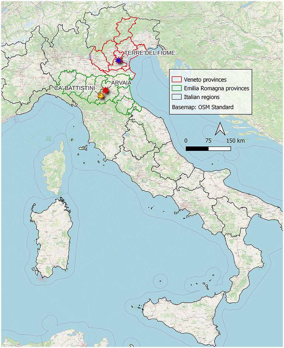
Figure 1. Location of the three farms under study in Italy.
Le Terre del Fiume was selected as an example of a neo-rural family-run farm located in a peri-urban zone, on the outskirts of the city of Padua. Its territorial context is characterized by the coexistence of residential areas, extensive crops, and infrastructure (among which is a small civil airport). Since its foundation, Le Terre del Fiume has moved toward ecological restoration of the territory, seen as one of the main tasks of agriculture. This also led the farm to actively participate in citizen networks opposing further urban development in the area and working toward the creation of an agricultural park in which social uses and agricultural production can coexist. Its production mainly consists of cereals, vegetable crops, and processed products directly sold to consumers on-site.
Ca' Battistini is a family-run peasant farm located in the Apennine Mountains, 40 km southwest of the city of Bologna. The surrounding area is dominated by grasslands, non-irrigated extensive crops, and oak forests. As confirmed by cadastral maps and old aerial photos, such woods result from the naturalization of abandoned wooded pastures, resulting in various other tree species (ash, alder, willow, pear, and cherry tree) interspersed among oaks. Ca' Battistini is one of the founding members of the Campi Aperti association, a 21-year-old network of farmers involved in food sovereignty struggles at the local, regional, and national levels. The association currently organizes several farmer markets in the city of Bologna on a weekly basis (Paltrinieri and Spillare, 2018; Angelis and Diesner, 2020; Diesner, 2020; Alberio and Moralli, 2021; Ferrando et al., 2021; Rossi, 2022). Vegetable and fruit crops coexist with the prevalent production of cereals, used as raw materials in the cooperative brewery hosted on the farm.
Arvaia was selected as an example of CSA (community-supported agriculture), thus differing in its organizational structure from the previous two case studies. It was founded in 2013 as a cooperative of citizens willing to be directly involved in the sustainable production of food. Its operations and political stance are based on the participation of its members in three yearly assemblies. Its budget is covered by raising shares through a solidarity-based system: the amount each member contributes is flexible, while the distribution of the products is equal and independent of the size of the share (Rossi, 2017; Paltrinieri and Spillare, 2018; Piccoli et al., 2021). This peri-urban farm is located on the outskirts of the city of Bologna, where a diverse mix of crops coexists alongside industrial and commercial areas. The farm's production is quite diverse, including cereals, small fruits, vegetables, fruit, and protein crops. Additionally, a small section of the land is occupied by a vineyard.
2.2. Input data sourcing and preliminary processing
The Main Agroecological Structure of the selected case studies was calculated following the methods proposed by León-Sicard (2021). It has to be noted that the index is still under development and that further modifications have been proposed in subsequent works (Quintero et al., 2022a). The original structure of the index was preserved here, thus calculating 10 criteria: four dealing with landscape features and six with cultural parameters. A detailed workflow dealing with the specific geoprocesses used for adapting such an index to the territorial context of the chosen case studies is available in Supplementary material. A quick overview of the workflow is also provided in Figure 2.
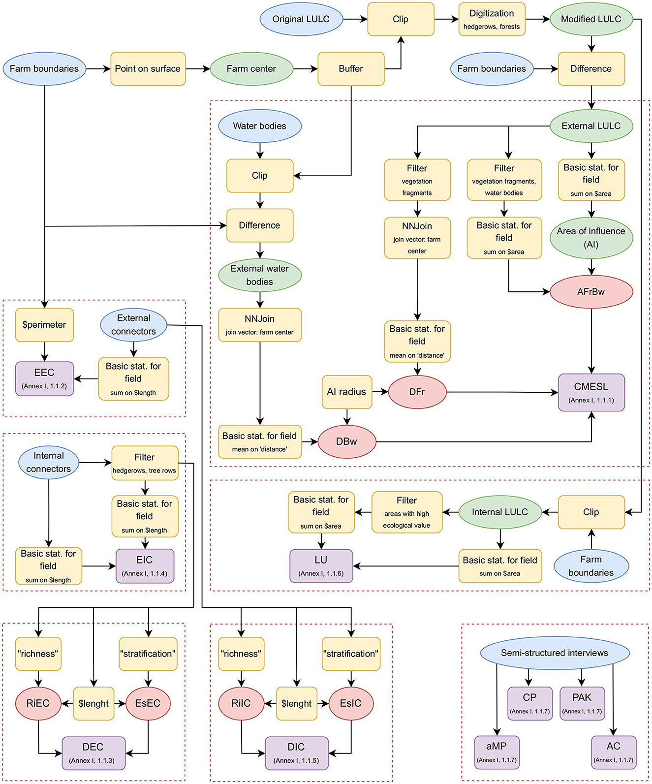
Figure 2. Overview of the proposed workflow. Input data are marked in blue, geoprocesses in yellow, intermediate data in green, indicators in red, and criteria in purple. Among brackets (in criteria frames) is the reference paragraph of Supplementary material detailing the workflow for each single criterion.
Unless otherwise stated, all the processing steps were carried out in QGIS 3.16.x.
The farm boundaries were determined using a combination of different methods: pre-existing digitization of Le Terre del Fiume and Ca' Battistini boundaries were modified according to cadastral units, while in the case of Arvaia, pre-existing maps were digitized using the QGIS Georeferencer tool. Field visits were then carried out, during which the QField app was used to ground-truth these boundaries with the participation of farmers.
The center of each farm was calculated by using the processing algorithm Point on the Surface. As suggested by León-Sicard (2021), a circular area of influence (AI) with a radius proportional to the longest side of the farm was identified. Such a radius was here defined as equal to the longest side (as opposed to the original proposal, where it was suggested to measure double the longest side) to avoid taking into consideration residential zones, a problem that could particularly affect the two peri-urban farms. The Buffer processing algorithm was then used for calculating AI. Since Ca' Battistini is composed of two different parts located a few kilometers away, a buffer was calculated around the center of each part.
Land use/land cover (LULC) vector maps were obtained from regional geoportals (Veneto and Emilia-Romagna regions) and clipped using AI buffers as overlays. The resulting maps were further modified by manually digitizing hedgerows and forest patches (1:1,000 scale). Regional ortho-photos (AGEA 2018 in the case of the Veneto region, CGR 2018 for Emilia-Romagna) were used as base maps. LULC maps of both the AI and the area inside farm boundaries were then obtained from the modified LULC map using Clip and Difference processing algorithms. The input dataset and its links are presented in Table 1.
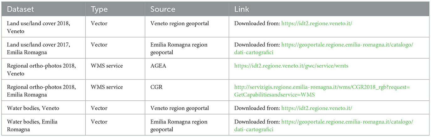
Table 1. Main input dataset used and their sources.
Vector layers representing water bodies were obtained from regional geoportals, clipped using the AI buffer as an overlay, and then divided (external or internal to the farm boundaries) using the Clip and Difference algorithms.
Two participatory mapping sessions were then carried out on each farm to incorporate farmers' knowledge into the final maps and verify the mapped data with their help (Figure 3). In the first session, paper maps (created with the QGIS Print layout tool) were used to identify elements of interest. Markers were used to create interpretative maps, highlighting features and covers that were not previously incorporated. In the second participatory mapping session, walking transects through the farm were carried out with farmers. The QField app was used to digitize new features and fill attribute table fields. Final maps representing LULC, internal and external connectors, and water bodies were obtained as an output of such participatory mapping sessions. These activities initiated discussions about the current conditions, past developments, and future prospects of the agroecosystems, elements that were later investigated through semi-structured interviews while evaluating qualitative criteria, as described in the following paragraphs.
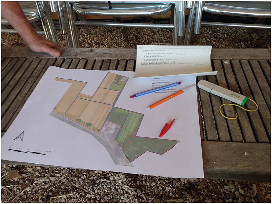
Figure 3. Participatory mapping: preliminary data being checked with farmers in the field.
2.3. Criteria structure and evaluation
2.3.1. Connection with the Main Ecological Structure of the Landscape (CMESL)
This parameter describes the spatial relationship of the agroecosystem with the elements composing the surrounding landscape, with a focus on vegetation fragments and water bodies. Such landscape features are conceived as elements preserving biodiversity, influencing the functional processes inside the agroecosystem. For this purpose, indicators DFr and DBw are calculated considering the average distance of vegetation fragments and water bodies from the center of the farm and the distance is weighed based on the radius of the calculated area of influence around the farm. A third indicator, AFrBw, represents the percentage of AI covered by such elements. The parameter was calculated using QGIS, according to the workflow detailed in paragraph 1.1.1 (Supplementary material).
2.3.2. Extension of External Connectors (EEC)
This parameter evaluates the linear extension of vegetation connectors (hedgerows and tree rows) located on the farm perimeter. The parameter was calculated using QGIS, according to the workflow detailed in paragraph 1.1.2 (Supplementary material).
2.3.3. Diversity of External Connectors (DEC)
The parameter DEC aims to estimate the degree of ecological function of vegetation connectors located on the farm perimeter. For this purpose, it is divided into two indicators dealing with species richness (RiEC) and vertical stratification (EsEC). Weighting factors proposed by the authors are applied to the sampled values of richness and stratification, dividing them into classes (León-Sicard, 2021). The parameter was calculated using QGIS, according to the workflow detailed in paragraph 1.1.3 (Supplementary material).
2.3.4. Extension of Internal Connectors (EIC)
The EIC parameter measures the extension of vegetation connectors inside the farm, calculated as the percentage of interior farm divisions composed of living structures (hedgerows, tree rows). The parameter was calculated using QGIS, according to the workflow detailed in paragraph 1.1.4 (Supplementary material).
2.3.5. Diversity of Internal Connectors (DIC)
This parameter is comparable in its aim and structure to DEC, composed of two indicators dealing with richness (RiIC) and stratification (EsIC). It differentiates from the former as its main focus is vegetation connectors located inside the farm. The parameter was calculated using QGIS, according to the workflow detailed in paragraph 1.1.5 (Supplementary material).
2.3.6. Land Use (LU)
This parameter focuses on measuring the percentage of the farm area occupied by vegetation that benefits agrobiodiversity. The parameter was calculated using QGIS, according to the workflow detailed in paragraph 1.1.6 (Supplementary material).
2.3.7. Agricultural Management Practices (aMP)
The aMP parameter aims to qualitatively investigate the approach of farmers toward agriculture, with a focus on their agricultural management practices.
Four indicators are taken into consideration:
• Seeds (S): origin, type, production, and conservation;
• Soil preparation (SP): type and intensity of tillage, use of complementary practices (green fertilization, cover crops, mulching, fallow, harvest residue management);
• Fertilization (F): fertilizer origin and type; use of rotation; use of complementary practices;
• Phytosanitary management (PM): use of complementary practices for weed management, tools, and approaches used for pest control
The single indicators were calculated through semi-structured interviews, as further detailed in paragraph 1.1.7 (Supplementary material).
2.3.8. Conservation Practices (CP)
This parameter aims to assess the degree of application of conservation practices on each farm.
It is composed of three indicators:
• Soil conservation practices (CsP): erosion control methods, fertility conservation;
• Water conservation practices (CwP): water body protection, water collection, use of hydric balance methods, water analysis, presence of contaminants;
• Biodiversity conservation practices (CbP): reforestation, natural area preservation, introduction of autochthonous species, introduction of beneficial plants, habitat protection or enrichment, germplasm banks.
Also in this case, the single indicators were calculated through semi-structured interviews, as further detailed in paragraph 1.1.7 (Supplementary material).
2.3.9. Perception, Awareness, and Knowledge (PAK)
This qualitative parameter aims to investigate the degree of environmental awareness, knowledge, and conceptual clarity on the role and importance of agrobiodiversity expressed by farmers. These factors are also assessed in their intersection with the perception of the territory and with the choice to act toward its preservation. Measuring this parameter required extensive interaction with farmers through semi-structured interviews as a starting point for in-depth discussion.
2.3.10. Action Capacity (AC)
This parameter aims to measure social, organizational, political, economic, and logistic external factors impacting the farmer's capacity to preserve or enrich agrobiodiversity.
Four indicators are considered:
• Economic and Financial Capacity (EfC): economic resources, access to credit, and access to institutional support programs;
• Logistic Capacity (LC): availability of labor, tools, plant resources, access to transportation means, and infrastructure;
• Management Capacity (MC): relationships with networks and associations, alliances with the community, relationships with institutions, access to information, and planning tools;
• Technological and Technical Capacity (TTC): access to agroecological technical assistance and access to institutional programs that support the preservation and management of agrobiodiversity.
The single indicators were calculated through semi-structured interviews, as further detailed in paragraph 1.1.7 (Supplementary material).
2.4. Calculation of MAS value
The values of the single criteria were normalized using the tables proposed by León-Sicard (2021). The final value of the index was obtained by averaging the values of the ten criteria, as in paragraph 1.2 (Supplementary material). An overview of the calculated values is available in Table 2 and Figure 4.
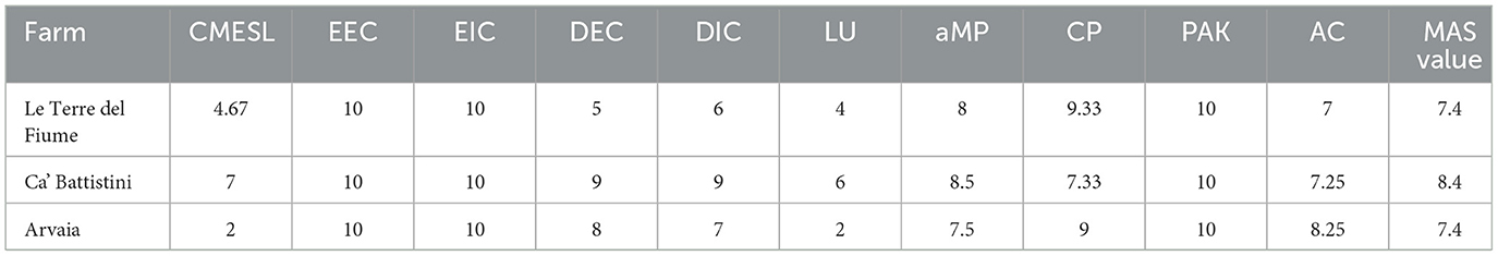
Table 2. Values of the ten calculated criteria and of the final MAS.
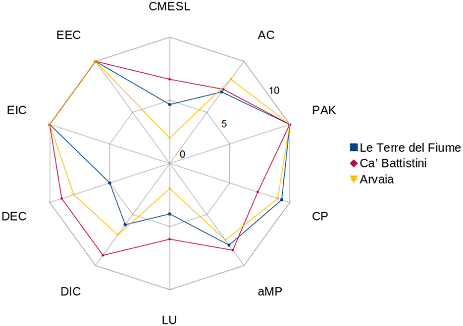
Figure 4. Values of the ten calculated criteria.
3. Results and discussion
The CMESL value has been observed to be deeply linked to the territorial context of each farm (Figure 5). The peri-urban area surrounding Le Terre del Fiume (4.67), in which agricultural areas are mixed with residential zones, justifies the value of AFrBw (3). Forest patches are highly fragmented (AFrBw = 3) and river bodies (Bacchiglione river and canals) are close to farm boundaries (DBw = 8). A similar territorial context characterizes Arvaia (2), located in an area where extensive crops and orchards coexist with industrial areas and an abandoned sand mine. Landscape structures considered in DFr (3) mainly consist of hedgerows, small forests, and grass patches in interstitial areas, only covering 13% of AI (AFrBw = 0). The bigger water bodies (Reno and Lavino rivers) are outside the AI buffer, which only includes smaller canals (DBw = 3). The situation dramatically changes in Ca' Battistini (7): over 75% of AI is constituted by forests and grasslands, with a positive influence on AFrBw (8) and DFr (6). The farm borders the Samoggia stream and is surrounded by several canals (DBw = 6).
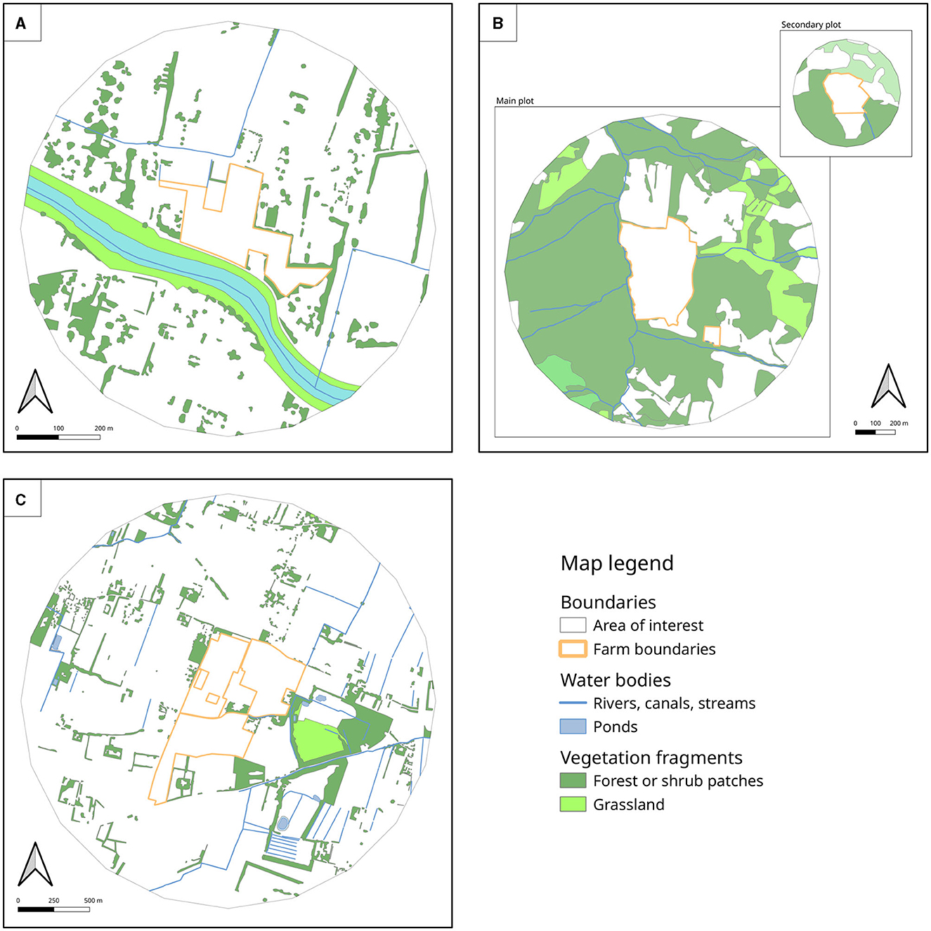
Figure 5. CMESL: vegetation fragments and water bodies inside the Area of Influence of the selected case studies. Le Terre del Fiume is represented in (A), Ca' Battistini in (B), and Arvaia in (C).
If CMESL values are highly impacted by external territorial factors, criteria dealing with internal and external connectors (EEC, EIC, DEC, DIC) start to show the role of farmers' agency in co-creating the landscape structure (Figure 6). Artificial fences are rare on all the studied farms, and green connectors are generally used. In Le Terre del Fiume, the conservation of pre-existent hedgerows and tree rows is complemented by new plantations of such connectors (EEC = 10; EIC = 10). In addition, DEC (5) and DIC (6) benefit from the presence of forest areas and connectors composed of purposefully chosen plant species planted to increase in-farm connectivity. Similarly, Arvaia has also carried out intentional plantings of new hedgerows and tree rows. Almost 90% of the boundaries result to be constituted by such connectors, that have been placed also among most parcels (EEC = 10; EIC = 10). The preservation and management of Vite maritata plantings (a traditional association of vine and maple, with the latter acting as a living trellising structure for the former) interspersed with other tree species also impact the values of DEC (8) and DIC (7). In Le Terre del Fiume and Arvaia, a stark contrast is present between newly planted connectors, showing higher stratification and richness values, and street-side tree rows managed by other actors. Forests and hedgerows cover almost 90% of Ca' Battistini boundaries, also connecting different parts of the farm (EEC = 10; EIC = 10); richness and stratification parameters benefit from the high diversity of species present in the local oak forests (DEC = 9; DIC = 9).
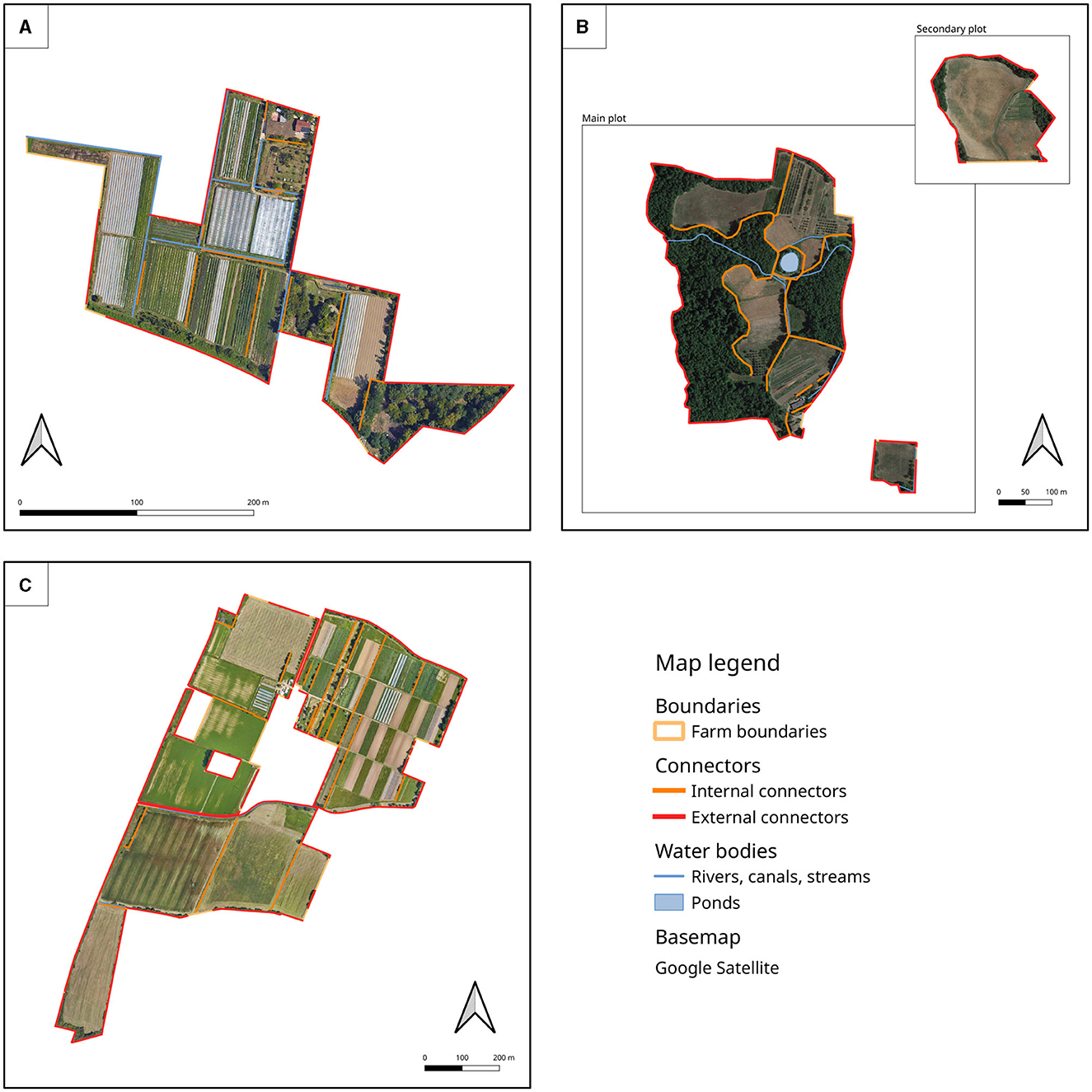
Figure 6. EIC and EEC: internal and external connectors in the selected case studies. Le Terre del Fiume is represented in (A), Ca' Battistini in (B), and Arvaia in (C).
Different degrees of intentional planting and preservation of vegetation covers with a high ecological value were observed in all the considered farms, impacting LU values (Figure 7). Such covers are present in over 40% of the area of Le Terre del Fiume (LU = 4) and over 50% of Ca' Battistini (LU = 6), while in Arvaia, this percentage is estimated at 23% (LU = 2). A gradient is present inside this farm, the biggest among the considered case studies: while the northern part presents a complex matrix of different crops and connectors, the southern one is characterized by larger parcels dominated by extensive crops.
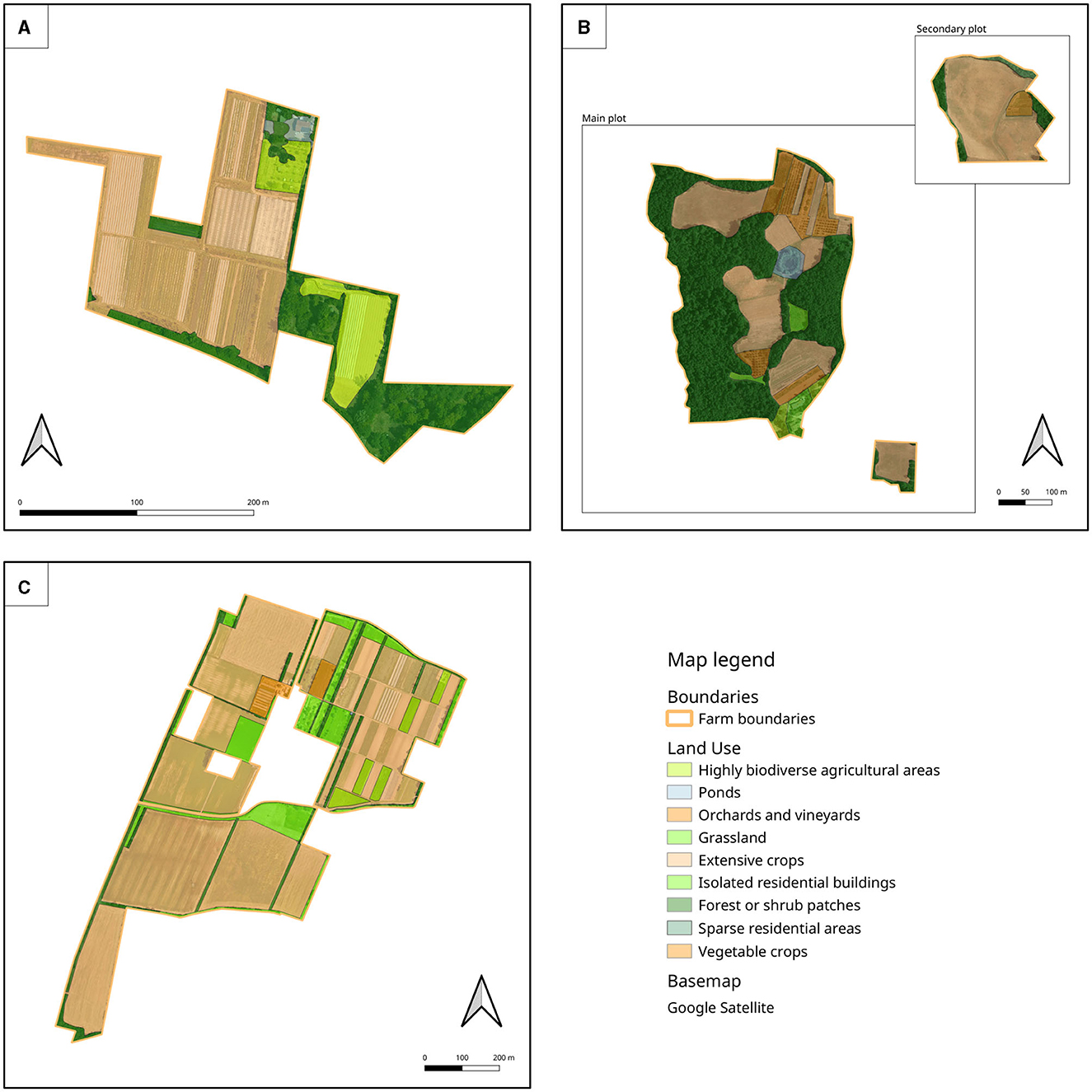
Figure 7. LU: land use in the selected case studies. Le Terre del Fiume is represented in (A), Ca' Battistini in (B), and Arvaia in (C).
In the context of aMP, all the studied farms source plant materials from both seed self-production and external nurseries. Le Terre del Fiume (aMP = 8) tries to support actors focusing on varieties adapted to organic farming, while both Ca' Battistini (aMP = 8.5) and Arvaia (aMP = 7.5) also grow evolutionary populations (Ceccarelli et al., 2022) as part of a multi-year effort aiming to select locally adapted populations. All the considered case studies widely use rotations and complementary practices. Weeds are controlled through mulching or mechanical intervention. As regards pest management, products allowed in organic farming are used in Le Terre del Fiume, while the other two farms tend to reduce their use in emergencies. Arvaia mainly focuses on preventive measures (repellents, physical barriers, removal of pests during the early stages of infestation), while Ca' Battistini benefits from a high degree of biological control due to the vast presence of ecological infrastructure in and around the farm. Experiments in the production of organic fertilizers and microbial preparations are carried out to a different degree in all the considered case studies, also in collaboration with university researchers. A high degree of interest in experimenting with novel practices was generally observed.
High CP values were observed in all the considered farms, characterized by the fundamental idea of “doing agriculture backed by an idea” (i.e., ecological restoration and small-scale food production) expressed by one of the interviewees. Erosion is kept under control by the maintenance of permanent grass covers, anticipating sowing, extensive mulching, and the creation of canals; water bodies are adequately protected. Different degrees of soil and water analysis frequencies were observed depending on the farm: water is not analyzed or rarely analyzed in Ca' Battistini (CP = 7.33), as most of the crops are not irrigated, and Arvaia (CP = 9), as it comes from the public supply network, while the presence of polluted canals leads to frequent analyses and measures to prevent contamination in Le Terre del Fiume (CP = 9.33). Both Le Terre del Fiume and Arvaia work toward the preservation of fallow land and the intentional creation of ecological infrastructures with the explicit goal of creating habitats for arthropods, reptiles, birds, and amphibians. On the other hand, the landscape surrounding Ca' Battistini strongly affects its conservation practices: being the zone mostly comprised of forests and wild areas, less time has to be devoted to the intentional creation of new habitats if compared to the two peri-urban farms, while effort is given to preserving existing ecological infrastructures. All the farms have some degree of access to germplasm banks. Le Terre del Fiume manages a small seed bank on site, stressing how food sovereignty starts locally through the interaction of communities and networks. Ca' Battistini farmers are actively involved in peasant networks working to create shared germplasm banks, which are considered necessary to reach food sovereignty. In Arvaia, access to germplasm banks is mainly related to using evolutionary populations and collaborations with the university.
In all the considered case studies, the evaluation of PAK was linked with the cultural background of farmers and their relationship with the ecosystem, stemming from their awareness regarding conservation, their reoccurring academic training in agricultural or natural sciences, their reflection and further investigation on ways to make their production processes more ecologically and socially sound. In Le Terre del Fiume (PAK = 10), the farmer once again highlighted how agriculture should be considered a way of practicing conservation ecology without idealizing traditional agriculture. The academic education in agricultural sciences (whose mindset and framework are partially criticized) is complemented by an ongoing collaboration with other farmers, university professors, and technicians in the context of horizontal experiential schooling. In Ca' Battistini (PAK = 10), farmers stressed how the preservation of biodiversity is fundamental on an ecological, social, and political level and has represented a key factor in their choice of doing agriculture. High value is conferred to their academic background (MSc and PhD levels in Agricultural Sciences and Forest Ecology) and experience in research institutes. It is noted how the first years after the farm's foundation have been devoted to making it economically viable and how further work on ecological aspects has only started once such bases were established. Arvaia (PAK = 10) interviewees also highlighted how the recovery of traditional rural landscape structures had represented a key point since the beginning: creating and maintaining ecological infrastructures are conceived as collective care for a common. Keeping the farm open to citizens willing to visit it for leisure or communal activities is also linked to this mindset. Academic backgrounds vary among members: some have university degrees in agricultural sciences, while others attended shorter educational classes. Regular visits to other farms are carried out to exchange knowledge. Additionally, a few members of the CSA hold teaching positions in the context of a Master of Philosophy at the University of Bologna.
Analyzing AC, different outlooks on the availability of funding are observed. Le Terre del Fiume (AC = 7) and Ca' Battistini (AC = 7.25) deem institutional support programs as almost non-existent, as the requisites for accessing the few available public programs are usually targeted to bigger farms, while Arvaia (AC = 8.25) manages to get further financing by participating in regional and university programs. Unlike the other two family-run farms in the study, Arvaia determines its budget according to the amount of funds collected during the yearly “auction,” in which each member finances a share of the cooperative through an open donation. In Ca' Battistini, it is emphasized how the earnings that support on-site research on agroecological practices come from the sale of transformed products on one side and voluntary work on the other. Limited financial resources also affect the ability to hire an adequate number of co-workers. A similar set of problems is also expressed by Arvaia interviewees. The availability of means of transportation, tools, and plant material is generally deemed sufficient; the possibility of creating a collectively managed plant nursery has been investigated by Ca' Battistini in the past but has been abandoned due to stringent regulatory requisites. A common trait among the studied farms is a negative evaluation of the relationship with institutions. Ca' Battistini emphasizes that there is almost no interlocution or access to programs for farms located outside protected areas, and the few existing initiatives are more focused on defining and protecting typical products than preserving biodiversity. Arvaia views such relationship as deeply ambiguous. On the one hand, the municipality benefits from the existence of the CSA in creating its public image. On the other hand, it does not offer any real support. The situation changes if the capacity to form alliances with local actors is considered. Le Terre del Fiume considers local communities to be necessary to put together diverse abilities and aptitudes, working in the direction of fostering small-scale agriculture as a tool to reconcile ecological conservation and the creation of local economies. Ca' Battistini farmers are among the founders of Campi Aperti (an association mainly dealing with food sovereignty) and are involved in provincial and regional networks working on such topics. Arvaia has also participated in such networks since its foundation. A huge impact of the social context is seen in the availability of agroecological technical assistance, seen as lacking in Le Terre del Fiume and sufficient in the other two case studies. A few decades devoted to community building in the area surrounding Bologna are hypothesized to impact such a difference.
Averaging the values of 10 considered indicators, the values of MAS were calculated to be 8.4 for Ca' Battistini and 7.4 for Le Terre del Fiume and Arvaia.
4. Conclusions
A few possible changes and integrations to the original index may be considered in view of further applications to European agroecosystems. A bottleneck was identified in the degree of data availability and quality describing the distribution and nature of green infrastructures in the area of influence. This was especially clear in peri-urban areas, where such elements often cover areas too small to be represented at the scale commonly used in LULC maps. At the same time, manual digitization, as carried out in this study, may be considered too burdensome in other contexts. Alternative mapping paths may be considered depending on future research goals.
On the one hand, a participatory approach could involve a broader engagement of local actors. On the other hand, a technical approach may map green infrastructures by means of remote sensing, following protocols already present in the literature (Tansey et al., 2009; Hellesen and Matikainen, 2013; Betbeder et al., 2014; O'Connell et al., 2015; Scholefield et al., 2016). The extreme fragmentation of forest patches (as considered in DFr) in peri-urban areas may suggest weighting their distances from the farm centroid on their area. Further modifications should also consider the latest developments in the structure of the index (Quintero et al., 2022a).
As MAS was originally conceived to be applied to Colombian farms, restructuring the index to make it more suitable for the European agricultural context represents another potential avenue of development that was only partially tackled in this study. This adaptation would also allow us to mitigate excessive influence of different contexts on farm comparison, preventing the farmer's agency from becoming obscured. It may be considered how the index could be of greater use in diachronically comparing the same farm to focus on its developments through time or in comparing farms located in similar contexts. The relevance of both the surrounding landscape and social factors is already evident in the present study, which explores both the geographical dimension (with farms located in peri-urban and rural areas) and the social dimension (with case studies in areas with different degrees of associative, grassroots, or institutional support). Further modifications may involve different scaling of species richness weighting factors (considering local floristic assemblages). Artificial divisors are used less in Europe than in Colombia, so their importance in criteria such as EEC and EIC may also be reconsidered. At the same time, considering its correlation with species richness, hedgerows area may be considered a further factor of interest in DEC and DIC (Sitzia et al., 2013).
As León-Sicard (2021) suggested, the area of influence may be better identified in pre-existing geographical features. Considering the analyzed case studies, these features may have been identified in the surrounding rural park (Le Terre del Fiume), in the area among the rivers Reno and Lavino and road infrastructures (already used in previous studies on Arvaia), and in the hydrographic basin (Ca' Battistini).
Water bodies reported to be highly polluted by farmers were filtered out of the analysis. An indicator dealing with the presence of elements of ecological risk may be useful in future studies to further emphasize their presence. At the same time, the presence of water bodies inside farms may be further valorized by a dedicated indicator: in all the case studies, canals, streams, ponds, and wetlands were also preserved for habitat creation.
All these potential changes could be easily integrated into the GIS workflow proposed in the present article.
Applying the index to three Italian farms allowed us to consider factors that are often neglected when analyzing rural areas. We were able to place these factors side by side—in their respective integration and interaction—with elements already taken into consideration by landscape ecology. Among those, the creation and conservation of ecological infrastructures, the choice of sustainable farming techniques and the symbolic, cultural and political milieus backing farmers' daily actions and influences on the territory. By focusing on the interaction of human factors with the ecosystem, the authors justify their decision to aggregate the selected metrics around the agricultural management unit (in our case, the farm or Community-Supported Agriculture project). This approach bridges landscape ecology with approaches and standpoints emerging from the debate on agroecology, which encompasses practice, a scientific framework, and a movement. The primary objective of this approach is to highlight the decision-making and mindset of farmers in their interaction with the landscape (Cleves-Leguízamo et al., 2017; León-Sicard et al., 2018; León-Sicard, 2021).
Focusing on the participative dimension, this index could be used as a tool for the activation of bottom-up territorial processes. The recognition of the existence and action of farming communities may thus finally make its entrance into territorial planning, also through the creation of cartographic outputs taking into consideration agricultural management units as active parts of the landscape. This may lead to the creation of agroecosystem maps on a regional or national level, as suggested by the authors and, to some extent, already tested in Colombia (León-Sicard et al., 2015). In such cases, being the scale smaller, aggregates of farms with similar characteristics may be identified and described collectively, with a possibility of sampling representative ones.
Previous studies carried out in South America (Vargas and León-Sicard, 2013; Cepeda-Valencia et al., 2014; Cleves-Leguízamo and Jarma-Orozco, 2014; Daza-Cruz, 2020) had the goal of investigating the correlation between MAS and a number of variables (pollination services, human appropriation of net primary production, climate change resilience, and biological pest control). The validation of the index for further variables may represent a possible line of research.
On a farm level, the index can provide an analytical framework, possibly allowing farmers to understand how to improve ecological infrastructure (León-Sicard, 2021). Diachronic analyses of the evolution of territories after agroecological farm settlements are also enabled (Pinzón Cortés, 2014).
The structure of the index itself requires strong interdisciplinary integration (agricultural and forest sciences, landscape ecology, and sociology are, at the very least, involved), and an active debate among these disciplines will be desirable and necessary in view of future studies.
Data availability statement
The raw data supporting the conclusions of this article will be made available by the authors, without undue reservation.
Author contributions
VR: Conceptualization, Data curation, Investigation, Methodology, Software, Writing—original draft. DC: Conceptualization, Supervision, Writing—original draft. MD: Conceptualization, Supervision, Writing—review and editing.
Funding
The author(s) declare that no financial support was received for the research, authorship, and/or publication of this article.
Conflict of interest
The authors declare that the research was conducted in the absence of any commercial or financial relationships that could be construed as a potential conflict of interest.
Publisher's note
All claims expressed in this article are solely those of the authors and do not necessarily represent those of their affiliated organizations, or those of the publisher, the editors and the reviewers. Any product that may be evaluated in this article, or claim that may be made by its manufacturer, is not guaranteed or endorsed by the publisher.
Supplementary material
The Supplementary Material for this article can be found online at: https://www.frontiersin.org/articles/10.3389/fsufs.2023.1259419/full#supplementary-material
References
Alberio, M., and Moralli, M. (2021). Social innovation in alternative food networks. The role of co-producers in Campi Aperti. J. Rural Stud., 82, 447–457. doi: 10.1016/j.jrurstud.2020.10.007
Altieri, M. A. (2002). Agroecology: the science of natural resource management for poor farmers in marginal environments. Agric. Ecosyst. Environ. 93, 1–24. doi: 10.1016/S0167-8809(02)00085-3
Angelis, M. D., and Diesner, D. (2020). “‘A revolution under our feet': Food sovereignty and the commons in the case of Campi Aperti,” in Commoning the City. London: Routledge. eds Özkan, D., and Güldem B. B.
Berthet, E. T., Bretagnolle, V., and Gaba, S. (2022). Place-based social-ecological research is crucial for designing collective management of ecosystem services. Ecosyst. Serv. 4, 101426. doi: 10.1016/j.ecoser.2022.101426
Betbeder, J., Nabucet, J., Pottier, E., Baudry, J., Corgne, S., and Hubert-Moy, L. (2014). Detection and characterization of hedgerows using TerraSAR-X imagery. Remote Sens. 6, 3752–3769. doi: 10.3390/rs6053752
Bicksler, A. J., Mottet, A., Lucantoni, D., Mouhamed, R. S., and Barrios, E. (2023). The 10 Elements of agroecology interconnected: Making them operational in FAO's work on agroecology. Elementa 11, 1–21. doi: 10.1525/elementa.2022.00041
Ceccarelli, S., Grando, S., Salimi, M., and Razavi, K. (2022). “Evolutionary populations for sustainable food security and food sovereignty,” in Seeds for Diversity and Inclusion: Agroecology and Endogenous Development, eds Nishikawa, Y., and Pimbert, M. (Cham: Springer International Publishing), 121-136.
Cepeda-Valencia, J., Gòmez, P D, and Nicholls, C. (2014). La estructura importa: Abejas visitantes del café y estructura agroecológica principal (EAP) en cafetales. Rev. Colomb. de Entomol. 40, 241–250.
Chopin, P., Mubaya, C. P., Descheemaeker, K., Öborn, I., and Bergkvist, G. (2021). Avenues for improving farming sustainability assessment with upgraded tools, sustainability framing and indicators. A review. Agron. Sustain. Develop. 41, 3. doi: 10.1007/s13593-021-00674-3
Cleves-Leguízamo, J. A., and Jarma-Orozco, A. (2014). Characterization and typification of citrus production systems in the department of Meta. Agron. Colomb. 32, 113–21. doi: 10.15446/agron.colomb.v32n1.42164
Cleves-Leguízamo, J. A., Toro-Calderón, J., Martínez-Bernal, L. F., and León-Sicard, T. (2017). La Estructura Agroecológica Principal (EAP): Novedosa herramienta para planeación del uso de la tierra en agroecosistemas. Rev. Colomb. de Ciencias Hortícol. 11, 441–449. doi: 10.17584/rcch.2017v11i2.7350
Córdoba, C., Triviño, C., and Calderón, J. T. (2020). Agroecosystem resilience. A conceptual and methodological framework for evaluation. PLoS ONE, 15, 1–20. doi: 10.1371/journal.pone.0220349
Dalgaard, T., Hutchings, N. J., and Porter, J. R. (2003). Agroecology, scaling and interdisciplinarity. Agric. Ecosyst. Environ. 100, 39–51. doi: 10.1016/S0167-8809(03)00152-X
Daza-Cruz, Y. X. (2020). Apropiación humana de la producción primaria neta en sistemas de agricultura ecológica y convencional. Bogotà: Instituto de Estudios Ambientales, Universidad Nacional de Colombia.
De Marchi, M., and Diantini, A. (2022). “Participatory geographic information science: disclosing the power of geographical tools and knowledge in agroecological transition,” in Drones and Geographical Information Technologies in Agroecology and Organic Farming Contributions to Technological Sovereignty, eds De Marchi, M., Diantini, A., and Pappalardo, S.E. (Boca Raton: CRC Press), 25–44. doi: 10.1201/9780429052842-3
De Marchi, M., Pappalardo, S.E., and Diantini, A. (2022). “Agroecology and sustainable food systems: inquiring technological approaches,” in Drones and Geographical Information Technologies in Agroecology and Organic Farming Contributions to Technological Sovereignty, eds De Marchi, M., Diantini, A., and Pappalardo, S.E. (Boca Raton: CRC Press), 1–24. doi: 10.1201/9780429052842-1
De Olde, E. M., Oudshoorn, F. W., Sørensen, C. A. G., Bokkers, E. A. M., and De Boer, I. J. M. (2016). Assessing sustainability at farm-level: Lessons learned from a comparison of tools in practice. Ecol. Indic. 66, 391–404. doi: 10.1016/j.ecolind.2016.01.047
Diesner, D. (2020). Self-governance food system before and during the Covid-crisis on the example of CampiAperti, Bologna, Italy. Interface 12, 266–273.
Eichler Inwood, S. E., López-Ridaura, S., Kline, K. L., Gérard, B., Monsalue, A. G., Govaerts, B., et al. (2018). Assessing sustainability in agricultural landscapes: a review of approaches. Environ. Rev. 26, 299–315. doi: 10.1139/er-2017-0058
Ferrando, T., Claeys, P., Diesner, D., Pol, J. L. V., and Woods, D. (2021). “Commons and commoning for a just agroecological transition: the importance of de-colonising and de-commodifying our food system,” in Resourcing an Agroecological Urbanism: Political, Transformational and Territorial Dimensions, eds Tornaghi, C., and Dehaene, M. (Routledge, London), 61–84. doi: 10.4324/9780429433566-4
Gascuel-Odoux, C., Lescourret, F., Dedieu, B., Detang-Dessendre, C., Faverdin, P., Hazard, L., et al. (2022). A research agenda for scaling up agroecology in European countries. Agron. Sustain. Dev., 42(3). doi: 10.1007/s13593-022-00786-4
Gliessman, S. R. (1990). “Agroecology: researching the ecological basis for sustainable agriculture,” in Agroecology: Researching the Ecological Basis for Sustainable Agriculture, ed S. R. Gliessman, S. R. (New York: Springer), 3–10. doi: 10.1007/978-1-4612-3252-0
Hellesen, T., and Matikainen, L. (2013). An object-based approach for mapping shrub and tree cover on grassland habitats by use of LiDAR and CIR orthoimages. Rem. Sens. 5, 558–583. doi: 10.3390/rs5020558
León-Sicard, T. (2021). La estructura agroecológica principal de los agroecosistemas: perspectivas teórico-prácticas. Bogotá: Universidad Nacional de Colombia.
León-Sicard, T., Ponce, N., Vargas, C., and Gomajoa, L. (2015) Lineamientos conceptuales y metodológicos para cartografiar agroecosistemas en el mapa nacional de ecosistemas de Colombia (escala 1: 100.000). V Congreso Latinoamericano de Agroecología—SOCLA (La Plata).
León-Sicard, T., Toro Calderón, J., Martínez-Bernal, L., and Cleves-Leguízamo, J. (2018). The Main Agroecological Structure (MAS) of the agroecosystems: concept, methodology and applications. Sustainability 10, 3131. doi: 10.3390/su10093131
López-Ridaura, S., Masera, O., and Astier, M. (2002). Evaluating the sustainability of complex socio-environmental systems. The MESMIS framework. Ecol. Ind. 2, 135–148. doi: 10.1016/S1470-160X(02)00043-2
McIntyre, B. D., Herren, H. R., Wakhungu, J., and Watson, R. T. (2009). International Assessment of Agricultural Knowledge, Science and Technology for Development (IAASTD). Synthesis report: a synthesis of the global and sub-global IAASTD reports. Washington DC: Island Press
Méndez, V. E., and Gliessman, S. R. (2002). Un enfoque interdisciplinario para la investigacion en agroecologia y desarrollo rural en el tròpico latinoamericano. Manejo Integrado de Plagas y Agroecol. 64, 5–16.
Mottet, A., Bicksler, A., Lucantoni, D., De Rosa, F., Scherf, B., Scopel, E., et al. (2020). Assessing transitions to sustainable agricultural and food systems: a tool for agroecology performance evaluation (TAPE). Front. Sustain. Food Sys. 4, 1–21. doi: 10.3389/fsufs.2020.579154
O'Connell, J., Bradter, U., and Benton, T. G. (2015). Wide-area mapping of small-scale features in agricultural landscapes using airborne remote sensing. ISPRS J. Photogram. Rem. Sens. 109, 165–177. doi: 10.1016/j.isprsjprs.2015.09.007
Paltrinieri, R., and Spillare, S. (2018). “Collaborative consumption and trust-building processes in the emerging new food economy,” in Contemporary Collaborative Consumption, eds Cruz, I., Ganga, R., and Wahlen, S. (Wiesbaden: Springer Fachmedien Wiesbaden), 131–152. doi: 10.1007/978-3-658-21346-6_7
Perfecto, I., and Vandermeer, J. (2010). The agroecological matrix as alternative to the land-sparing/agriculture intensification model. Proc. Nat. Acad. Sci. 107, 5786–5791. doi: 10.1073/pnas.0905455107
Perfecto, I., Vandermeer, J., and Wright, A. (2019). Nature's Matrix: Linking Agriculture, Biodiversity Conservation and Food Sovereignty. London: Routledge. doi: 10.4324/9780429028557
Piccoli, A., Rossi, A., and Genova, A. (2021). A socially-based redesign of sustainable food practices: community supported agriculture in Italy. Sustainability 13, 11986. doi: 10.3390/su132111986
Pinzón Cortés, M. (2014). Transformación de la Estructura Agroecológica Principal en comunidades intencionales rurales (Ecoaldeas). Bogotà: Instituto de Estudios Ambientales, Universidad Nacional de Colombia.
Quintero, I., Daza-Cruz, Y.X., and León-Sicard, T. (2022a). Main Agroecological Structure: an index for evaluating agro-biodiversity in agroecosystems. Sustainability 14, 13738. doi: 10.3390/su142113738
Quintero, I., Daza-Cruz, Y.X., and León-Sicard, T. (2022b). “Connecting farms and landscapes through agrobiodiversity: the use of drones in mapping the Main Agroecological Structure,” Drones and Geographical Information Technologies in Agroecology and Organic Farming Contributions to Technological Sovereignty, eds M. De Marchi, A. Diantini, and S. E. Pappalardo (Boca Raton: CRC Press), 249–277. doi: 10.1201/9780429052842-14
Rossi, A. (2017). Beyond food provisioning: the transformative potential of grassroots innovation around food. Agriculture 7, 6. doi: 10.3390/agriculture7010006
Rossi, G. (2022). Agroecology: An Assessment of Campi Aperti Transformative Potential. Department of Earth Sciences, Uppsala: Uppsala University.
Sajadian, M., Khoshbakht, K., Liaghati, H., Veisi, H., and Mahdavi Damghani, A. (2017). Developing and quantifying indicators of organic farming using analytic hierarchy process. Ecol. Indic. 83, 103–111. doi: 10.1016/j.ecolind.2017.07.047
Scholefield, P., Morton, D., Rowland, C., Henrys, P., Howard, D., and Norton, L. (2016). A model of the extent and distribution of woody linear features in rural Great Britain. Ecol. Evol. 6, 8893–8902. doi: 10.1002/ece3.2607
Sitzia, T., Trentanovi, G., Marini, L., Cattaneo, D., and Semenzato, P. (2013). Assessment of hedge stand types as determinants of woody species richness in rural field margins. IForest 6, 201–208. doi: 10.3832/ifor0749-006
Tansey, K., Chambers, I., Anstee, A., Denniss, A., and Lamb, A. (2009). Object-oriented classification of very high resolution airborne imagery for the extraction of hedgerows and field margin cover in agricultural areas. Appl. Geograp. 29, 145–157. doi: 10.1016/j.apgeog.2008.08.004
Keywords: agroecology, community participation, geographical information systems, GIS, agrobiodiversity, European agroecosystems, landscape, community supported agriculture
Citation: Rettore VG, Codato D and De Marchi M (2023) How can GIS support the evaluation and design of biodiverse agroecosystems and landscapes? Applying the Main Agroecological Structure to European agroecosystems. Front. Sustain. Food Syst. 7:1259419. doi: 10.3389/fsufs.2023.1259419
Received: 15 July 2023; Accepted: 13 September 2023;
Published: 11 October 2023.
Edited by:
Roberta Selvaggi, University of Catania, ItalyReviewed by:
Monica Parlato, University of Catania, ItalyAngelo Pulvirenti, University of Catania, Italy
Copyright © 2023 Rettore, Codato and De Marchi. This is an open-access article distributed under the terms of the Creative Commons Attribution License (CC BY). The use, distribution or reproduction in other forums is permitted, provided the original author(s) and the copyright owner(s) are credited and that the original publication in this journal is cited, in accordance with accepted academic practice. No use, distribution or reproduction is permitted which does not comply with these terms.
*Correspondence: Valentino Giorgio Rettore, dmFsZW50aW5vLnJldHRvcmVAaW52ZW50YXRpLm9yZw==