Abstract
Land degradation and desertification affect around one-third of the land used for agriculture, undermining productivity, and farmers' livelihoods, and resilience. People in rainfed and dryland areas are the most vulnerable to the environmental and social impacts of degradation, yet opportunities to expand agricultural areas in order to meet the needs of an ever-growing population are limited and/or not feasible. On the bright side, there are opportunities to avoid, reduce and reverse land degradation (LD), however, it will require identifying areas that are suited to implement sustainable land management (SLM) practices and create an enabling environment that encourages such initiatives. In Morocco, latest available data from 2015 showed that 19 percent of its land over the total land area is degraded. In order to assess the level of degradation in rainfed landscapes of Morocco and identify the appropriate technological solutions in response to the driving forces and pressures, and to come up with a territorial planning strategy, analyses were carried out at different levels to identify the land degradation “hot spots” as well as the SLM “bright spots.” This paper sheds light on the decision support framework, co-developed with partners and applied in Morocco, the findings from national and subnational assessments of LD, as well as the process of participatory planning in selected communities of the Souss-Massa region for evaluation and scaling up of SLM good practices. The process led to the development of a “Territorial Planning Pact” as a tool for land use planning and a 3-year action plan to help decision-makers implement and mainstream SLM in the selected communities and guide similar processes throughout the region. The “Territorial Planning Pact” forms a base for planning and implementing the development program in the region led by key stakeholders. The paper presents the actions taken and concludes by highlighting the importance of integrating both biophysical and socio-economic information in a multi-level participatory process to identify the actions and responsibilities of various stakeholders and ensure sustainable management of limited natural resources and improved livelihoods for all.
Introduction
Land degradation and desertification affect around one-third of the land used for agriculture, undermining farmers' productivity, livelihoods, and food security (UNCCD, 2013; FAO, 2022a). People in dryland areas, where land and water resources management is a challenge, are the most vulnerable in terms of the long-term ecosystem degradation. Competition between land uses, climate change, and urbanization along with demographic factors are main drivers for accelerating LD in the Near East and North Africa region (NENA) (FAO, 2022b). Ineffective policies and poor governance across sectors with often top-down approaches exacerbate the issue. Opportunities to expand agricultural area, in NENA, are limited and/or not feasible. Yet, as the population and the food demand is expected to rise in the region, the challenge is how to increase productivity while using sustainably the natural resources (FAO, 2022b). Interactions between land components (soil, water, vegetation/ biodiversity) and the effects of climate and human activities determine the productivity and sustainability of any land use system (FAO, 2019).
There are opportunities to avoid, reduce and reverse the negative trend in favor of sustainability and resilience. It will require identifying areas that are suited for applying sustainable land and water management practices and creating an enabling environment that assists land users to adopt these practices. Sustainable land management (SLM) involves a range of complementary measures for the protection, conservation and sustainable use of land resources (soil, water, biodiversity) and the restoration or rehabilitation of degraded natural resources and their ecosystem functions (Montanarella et al., 2018). Globally, it is estimated that over 2 billion hectares of land can be rehabilitated with the use of SLM good practices (WRI, 2014). In the NENA region, about 3.5 million square km irrigated, rainfed cropland and rangeland agro-ecosystems are potentially suitable to apply SLM practices (Ziadat et al., 2014).
The response to address the above-mentioned challenges that relate to LD and affect agricultural production, requires solutions at different fronts; from the development of an evidence-based decision support system, policies and plans at different levels following participatory approaches to data collection and use for the implementation, scaling out and mainstreaming of SLM practices at farm and landscape level. To design effective policies and planning strategies for combating LD and SLM, decision makers need to have the knowledge/ evidence and appropriate tools that will help them adopt sustainable solutions and remove key national, subnational and local barriers to scaling up SLM through improved SLM decision support by linking sound scientific assessments of LD and SLM best practices with the mainstreaming of SLM priorities in national sectoral policies and investment programs (Bastidas Fegan, 2019).
Informed decision making supporting cross-sectoral and participatory dialogues is challenging, however several decision support tools are available to assess land degradation at different scales and identify sustainable solutions (FAO, 2017, 2018). These include geographical information systems (GIS), standardized methodologies, remote sensing and computer-based simulation models among others (Willemen et al., 2018). Liniger et al. (2019) note that despite the variety of decision support tools, these do not enable stakeholders in the planning process. Each tool has its own outcome and spatial application scale, however the demand for more inclusive approaches is growing. The role of stakeholders has been highlighted as a catalyst in understanding the landscape and adopting viable solutions (Turner et al., 2015). Without engaging stakeholders and local communities in the planning process, there is a significant risk of jeopardizing efforts to use sustainably the natural resources. Community-based governance systems involves the use of knowledge of different stakeholders and the recognition of local knowledge (Van Haren et al., 2019); and provide local empowerment. Participatory processes have proven to strengthen the ownership of decisions over solutions in tackling LD (De Vente et al., 2016). However, the challenge remains on how to make use of the evidence to support decision-making processes for SLM mainstreaming and scaling-out and remove local, regional and national barriers.
The following questions guided this research: How to design a strategy and targeted action plan for integrating SLM into national policy, planning and financial decisions in Morocco; How to create an enabling environment for efficient cross-sectoral and participatory land resources planning; In which way stakeholders can be better involved and contribute to local planning? What are the main drivers of land degradation and the best SLM solutions?
In order to create an effective mechanism that will comprise both governance processes and different planning tools, the SLM Decision Support Framework (DSF) to support informed decision-making processes for mainstreaming and scaling best agricultural practices in regional policies (Harari et al., to be published; Liniger et al., 2019) in Morocco was used and adapted.
The framework was developed as part of the Decision Support for Mainstreaming and Scaling up Sustainable Land Management (DS-SLM) project, funded by the Global Environment Facility (GEF) and implemented by the Food and Agriculture Organization of the United Nations (FAO) and the World Overview of Conservation Approaches and Technologies (WOCAT). The DSF project established a decision-support framework based on seven Modules. Morocco was one of the 15 project-countries that have implemented and tested the DSF. The DSF framework has a modular structure and Module 1 (Operational Strategy and Action Plan for mainstreaming and scaling out SLM) was designed to contain three Phases: Phase A includes review of strategies and actions and the development of an action plan; Phase B focuses on establishing and strengthening partnerships with institutions, provision of capacity development in LD and SLM assessments, SLM territorial planning, as well as implementation and scaling out of SLM; and Phase C focuses on the scaling out of SLM through policies, territorial strategies, incentives and financing mechanisms (Bastidas Fegan, 2019; Liniger et al., 2019; Harari et al., 2022 to be published) (Figure 1).
Figure 1
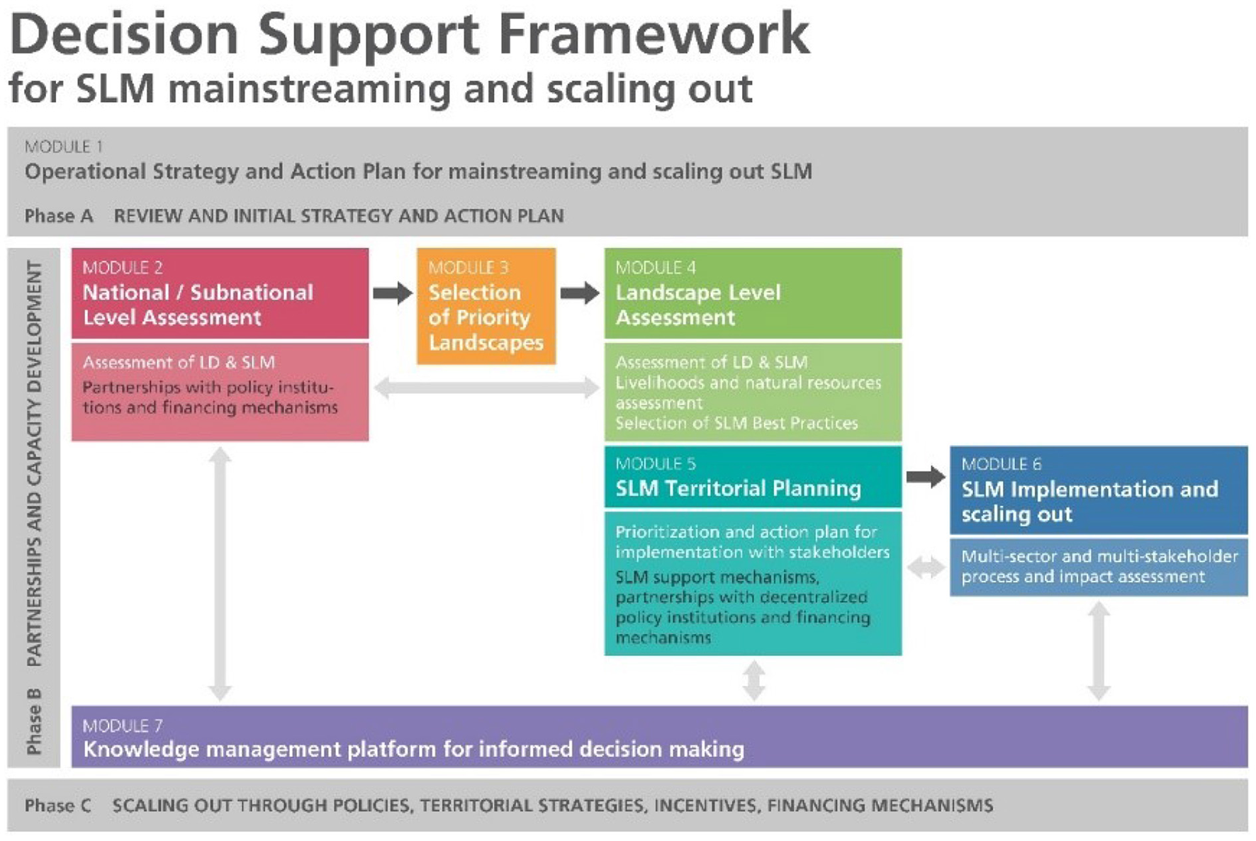
The modular structure of the Decision Support Framework (DSF) (source: Liniger et al., 2019; Harari et al., 2022 to be published).
In order to assess land potential successfully, land resources planning (LRP) should be put in place following the systematic assessment of land potential and alternative approaches to land use through a participatory and multi-stakeholder approach (FAO, 2017, 2018). Helping decision-makers to adopt appropriate options for land use and management while taking into consideration the local communities' needs, allows for a more efficient natural resources use and prevention of further degradation. Proper planning should help land users to select SLM good practices that support land and soil restoration in degraded areas.
Land degradation is a major impediment to achieving food security in Morocco. With more frequent droughts and water scarcity remaining important challenges for the agricultural sector. The latest available data from 2015 show that Morocco is among the countries with the highest percentage of degraded land over the total land area in the NENA region. This proportion reached 19 percent, approaching the world average of 20 percent (UNDESA, 2021). The impact of land degradation and desertification on the agricultural systems in Morocco was acknowledged through the development of the National Action Plan (NAP) to Combat Desertification back in 2001, with the following objectives: (i) adapt the NAP to the specificity of homogenous zones while taking into account the objectives of the UNCCD decennial strategy and synergies with other Rio Conventions such as UNFCCC and CDB in order to face the effects of climate change and loss of biodiversity; (ii) operationalize the NAP monitoring and evaluation system; and (iii) strengthen the NAP implementation within partnership frameworks. Since the adoption of the NAP, many efforts have been made through rural development programmes to revitalize the agricultural sector and support vulnerable rural communities. Of particular importance and relevance is the Plan Maroc Vert (PMV) or Green Morocco Plan launched in 2008 with an ambitious objective of making the agricultural sector a major driver of competitive and inclusive social and economic development through Solidarity Projects for small farmers (Pillar II) (MAPM, 2008) and High Value Projects (Pillar I). Within Pillar II, 989 projects were implemented for the benefit of 730 000 beneficiaries through fruit tree planting (438 455 ha), water development and management on 83 960 ha, 39 135 ha of rangeland improvements, construction of 545 km of rural access roads, labeling of 62 local products, and upgrading 720 farmer cooperatives (ADA, 2021; MAPMDREF, 2021). Sustainability impacts include improved incomes for small farmers through improved production and product value adding, better water use through drip irrigation (over 560 000 ha in 2018 vs. 128 000 ha in 2008), and converting cereal crops to more climate change resilient fruit trees (MAPMDREF, 2021).
Experience from past projects concerning land resources management in Morocco showed the importance of the participatory approach involving major stakeholders at different phases of the project cycle including local communities. The process includes: (i) resources assessment and diagnostics; (ii) capacity building; (iii) land resource planning; (iv) implementation; and (v) monitoring and evaluation. In order to assess the level of degradation and provide sustainable agricultural solutions in the Souss-Massa region, Morocco, land resources planning at subnational and local level was carried out following a community-based approach.
The paper sheds light on the methodology and findings from both subnational and local assessments of LD as well as it describes the participatory approaches that contributed to the development of a “Territorial Planning Pact” and a 3-year action plan in the Souss Massa region in Morocco. The paper has the following objectives: (i) to use and adapt the comprehensive DSF that can support multi-sectoral dialogue, provide LD and SLM assessment tools, promote sharing of best practices and support stakeholders' capacity development to the Souss Massa context; (ii) to provide and analyze the findings of the subnational and local level assessments; (iii) to recognize the role of stakeholders and local communities in the planning process; (iv) to formulate, with stakeholders participation, the Territorial Planning Pact and the 3-year action plan. This approach can be applied to other regions and countries based on the needs in managing natural resources in a participatory way.
Materials and methods
Study area
The Souss-Massa Region is one of the 12 Regions of Morocco (Figure 2). Its population reaches 2,671,933 inhabitants according to the 2014 census. The agricultural production in this region has an important contribution to national economy. The cultivated land is 453,445 ha and Souss-Massa is a major producer of vegetables, citrus and argan oil1 contributing to 9 percent of GDP2. However, the region is experiencing resource base depletion such as water and wind erosion, biodiversity loss and deforestation due to human pressures, unsustainable management practices and climate change.
Figure 2
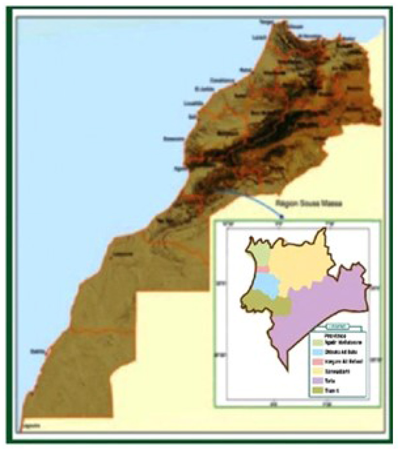
Map showing the Souss Massa region and its provinces.
The following physiographic zones can be distinguished within the Region from the North to the South:
-
A mountain area represented by the western part of the High Atlas Mountain within the Agadir Ida-Outanane and Taroudant provinces. This zone has a high biodiversity. The natural forest vegetation is dominated by Quercus rotundifolia, Tetraclinis articulata and Argania spinosa. Land use is dominated by forests grazed mostly by goats, with cultivated areas for subsistence agriculture;
-
The Souss plain, extending over the provinces of Agadir-Ida Outanane, Taroudant, Inezgane-Ait Melloul and Tiznit. The natural vegetation of this zone is dominated by Argania spinosa. The area is undergoing rapid changes in terms of land use, mainly through intensive agriculture and urbanization;
-
A second mountain zone represented by the Anti Atlas Mountain, extending over the provinces of Taroudant, Chtouka Ait Baha, Tiznit and Tata. Natural vegetation is dominated by sparse Argania spinosa on the north slopes and by Acacia raddiana on the southern slopes;
-
The Saharan zone south of the Anti Atlas Mountain corresponding to a Hamada (desert plateau) with sparse Acacia raddiana cover. This zone has a few oases but most of the land is used for grazing purposes.
For the local assessments, three pilot areas/communes in the Agadir-Ida Outanane province were selected based on their LD severity. The sites are Ameskroud, Tamri and Aziar identified within the framework of the National Action Plan to Combat Desertification (Figure 3).
Figure 3
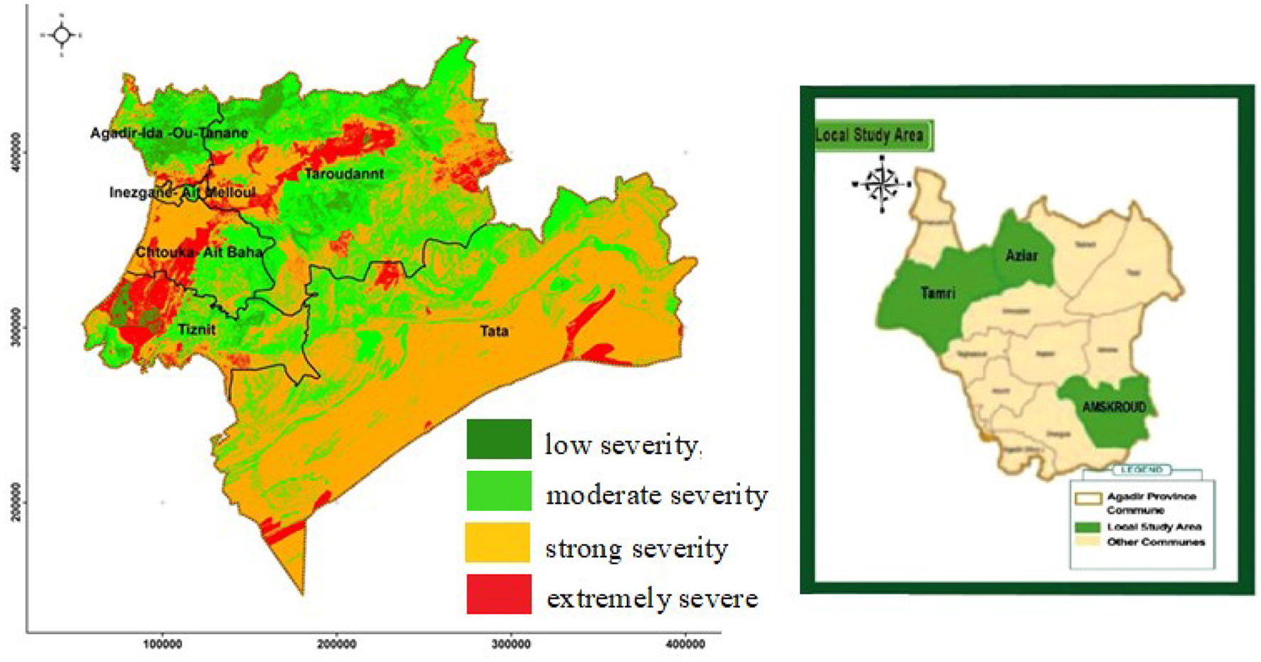
Map showing the three pilot areas/communes within the Agadir-Ida Outanane province for the participatory land resources planning process with the degree of severity of land degradation.
Method
Decision support framework
Several tools and methods are available, widely accepted and used in different projects and programmes to assess LD and SLM. In this study the DSF guides the process of evidence-based decision-making for mainstreaming and scaling-out of SLM in Morocco showcasing key and concrete activities applied at the landscape to the local level. The DSF follows seven modules with proposed tools and methods (Figure 1).
Guided by a national consultation process, the DSF was tailored to better reflect current advances in combating LD in Morocco and to respond to specific needs of stakeholders (Figure 4). The participatory approach aimed to foster stakeholder ownership of the process and encourage/reassure the sustainability of natural resources use and management.
Figure 4
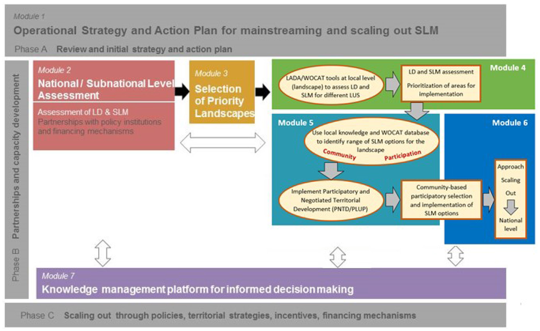
The DSF tailored to Morocco. LUS, land use system; PNTD, participatory negotiated territorial development; PLUP, Participatory Land Use Planning.
-
At landscape and local level (Module 4):
a. Identification of status, drivers, pressures, and impacts of LD and SLM and mapping of LD “hot spots” and SLM “bright spots.” Assess LD and SLM for different identified land use systems (LUS) (Schwilch et al., 2009, 2011; Liniger et al., 2013; Nachtergaele and Petri, 2013; Petri et al., 2019).
b. Local level assessment for analyzing biophysical conditions and livelihoods (socio-cultural and economic conditions) to understand in more details drivers and pressures in local areas (Bunning et al., 2016).
c. Identification and selection of priority areas for intervention at local level.
d. Identification and documentation of existing and promising SLM solutions (WOCAT, 2022), i.e., Technologies (WOCAT, 2019) and Approaches (WOCAT, 2016).
-
Territorial planning (Module 5): selecting and prioritizing potential and promising SLM practices and developing an action plan for the implementation and scaling-out of SLM (Module 6) through participatory negotiated territorial development (PNTD) (FAO, 2005) and Participatory Land Use Planning (PLUP) (Custović et al., 2020); The participation of communities is very important and is enforced by the law, requiring them to suggest activities for development;
This paper focuses on Module 5 of the DSF. As described above Module 5 uses the evidence generated under Module 4 related to LD and SLM assessment, in a multi-stakeholder process to consider LD challenges, and documented potential and promising SLM practices in land use and territorial planning.
Assessment of land degradation and sustainable land management
Regional maps of bioclimatic types, soil types, level of grazing pressure, land cover types and LUS were prepared (Rouchdi et al., 2018). To identify LUS, satellite images supported by field verification were used. The LUS map served as a base map and incorporates biophysical, management and socio-economic parameters (Nachtergaele and Petri, 2013). After having developed the LUS map, the LADA3-WOCAT4 questionnaire for mapping LD and SLM (Liniger et al., 2013; Petri et al., 2019) was used to assess drivers, pressures and impacts of LD and SLM as well as identify the so-called “hot spots” and “bright spots.” Regional maps for land cover types, main types of degradation, degradation index, direct and indirect causes of LD (specifically water erosion and biological degradation), severity of degradation and presence and spread of good practices were produced. The assessed “hot spots” were discussed with stakeholders at subnational level to identify priority landscapes. The “bright spots” provide SLM potential solutions for specific agro-ecological and socio-economic contexts.
The soil, water and vegetation components were assessed as follows (Nachtergaele and Petri, 2013):
-
Soil conditions and degradation: soil characterization, assessment of water and wind erosion, assessment of soil salinization;
-
Water resources: focus on quality and quantity;
-
Vegetation and rangelands quality: determination of plant cover, determination of density of woody plant species, assessment of vegetation quality, condition and trend.
For this study the LUS map of the Souss Massa region, in which the study area of Agadir-Ida Outanane province is located north-west, was established using the following data or layers: (i) the land cover map produced by NAPCCD in 2011; (ii) the forest inventory map; (iii) field observations; and (iv) Google Earth map.
The identified and selected priority areas for undergoing the territorial planning were the Amskroud, Aziar and Tamri communes. The work started with the selection of study sites within these study areas (see Figures 3, 5) by:
-
Establishing maps of the community territories (CT) which present the perceptions of land users;
-
Laying transect lines across different land use systems;
-
Identifying “hot spots” based on refined assessment of LD processes, their causes and impacts, at local level in collaboration with local stakeholders and communities and “bright spots.”
-
Assessing socio-economic conditions next to biophysical conditions provide more detailed findings and understanding from selected local assessment areas to feed into LD/SLM assessments and decision-making for scaling out.
Figure 5
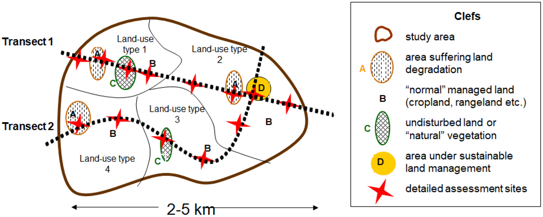
Detailed study sites along transect lines across land use types.
LUS were validated using the prepared LUS map in addition to site evaluations and field investigations. The LUS were determined and delineated using the following criteria and attributes:
-
LUS characteristics: vegetation type and major uses;
-
Socio-economic parameters: population density, livestock type;
-
Rangeland parameters: livestock pressure on natural ecosystems.
Verification of LUS as well as “bright and hot spots” and CT map development were done during participatory multi-stakeholder workshops where local authorities as well as local resource persons, and land users including forest managers were present.
Seven transect lines were selected on the maps of the three pilot areas/communes: two for Amskroud, three for Tamri, and two for Aziar. These transect lines were used to identify villages where socio-economic conditions were assessed through focus group discussions in the community territory; family surveys and the establishment of pentagons of capitals according to the LADA local assessment methodology (Bunning et al., 2016).
Documentation of sustainable land management good practices
The documentation of SLM good practices and their impact analysis is of paramount importance to keep policy makers informed and share knowledge among practitioners. To achieve this, the WOCAT standardized tools and methods for documentation, monitoring, evaluation and dissemination of SLM knowledge, covering all steps from data collection with several questionnaires, to the Global SLM Database and to using the information for decision support was used.
A SLM practice ideally consists of a SLM Technology, which refers to physical practices to control land degradation and/or improve productivity, and a SLM Approach, which focuses on methods and means to implement one or more SLM Technologies (including technical and material support, stakeholder engagement, etc.).
In Morocco, three Approaches and seven Technologies were documented (Sabir et al., 2017):
-
Approaches: rainwater collection, argan oil production, regeneration and rehabilitation of forests.
-
Technologies: temporary rest of argan tree stands from grazing (agdal), manure fertilization, pond of water (iferd), matfia (buried cement water tank to collect runoff water), deferred grazing, reforestation and terraces.
The Moroccan Approaches and Technologies documented in the framework of the DS-SLM project are accessible at the following link: WOCAT5.
Participatory territorial planning
Without addressing stakeholders' needs (including local communities) as part of integrated territorial planning, there is a significant risk of jeopardizing efforts to address local challenges and build resilience. In this context, and taking into account the importance of SLM on reducing the severity of LD and improving productivity and combating poverty and vulnerability particularly in the rural targeted communities, a dialogue was established with several stakeholders involved in this endeavor to negotiate and adopt the suitable SLM practices for each commune, which was endorsed by the local government. The entry points for the discussion were the results generated through the LADA local assessment exercises (Bunning et al., 2016) as well as experience from past projects in the region. The results of this diagnostics, including maps of land use systems, were used in a consultative workshop. This approach brought stakeholders together to agree and adopt a program of good land management practices and in identifying responsibilities for supporting community implementation of the recommended practices. Representatives from all three communes, prioritized areas for implementing suitable SLM practices as well as identified the main barriers for their adoption and implementation.
To ensure sustainability, a workshop brought farmers and other land users and managers together to negotiate and select the SLM practices based on the LD and SLM mapping as well as the LADA local assessment, which was supported by the local government. The participation of local representatives resulted in a very lively discussion of the real needs of communities in terms of sustainable land management. Procedures for selecting, creating the enabling environment and implementing SLM practices and the role of the stakeholders were discussed in detail.
The above activities assisted the preparation of the Concerted Territorial Planning Pact for the pilot project localities (Ameskroud, Tamri and Aziar) and its extension on a larger scale, with the following objectives: (i) strengthening delivery mechanisms for extension, awareness and training on SLM; (ii) implementation and spread of good SLM practices; (iii) regional capacity building for large scale implementation and scaling of SLM.
Representatives from the three communities identified potential areas for the implementation of SLM practices, being careful to distribute the activities equally among the different communes. Responsibilities for monitoring and support for the various activities were shared among those involved, including communities and institutions.
The territorial planning process was initiated after completion of the biophysical and socio-economic assessments. The following steps marked this process:
-
Presentation and validation of the methodology for designing the Territorial Planning Pact, with participation of the institutional parties, local authorities and local development associations and communities' representatives.
-
Evaluation of training needs for implementing SLM: The collection of baseline information for this evaluation was done through workshops with all stakeholders, in addition to a series of meetings and interviews with project stakeholders.
-
Organization of a “training of trainers” workshop on the management of land resources and communication tools for the extension of sustainable land management.
-
Organization of a regional consultation workshop to select good SLM practices and implementation areas covering a broad spectrum of land use systems and practices and to promote territorial approaches for implementation in the three rural communes.
The outputs of this process included:
-
A list of good practices for potential implementation, which were selected by mutual agreement and with the actual commitment (financial and technical) of stakeholders (State and NGO) and taking into account the priorities of each commune;
-
Identification of local demonstration areas for testing good practices in each of the communes;
-
A multi-stakeholder dialogue on relevant approaches and strategies for the implementation and scaling up of SLM.
-
Identification of simple and measurable indicators for monitoring the impacts of the selected good practices and the degree of adoption of these practices.
-
The Territorial Planning Pact: agreement of the Parties to implement participatory regional planning to improve SLM at local level. All parties have agreed to abide by the responsibilities entrusted to them to implement the agreement on a voluntary basis and work continuously to overcome obstacles and difficulties that may face implementation to achieve sustainable land management and neutralize the impact of land degradation.
-
A 3-year action plan was developed to integrate SLM at the provincial level and was based on the results and information from the previous steps, including those related to the implementation of good practices in the demonstration areas.
Results
Findings from subnational level assessment
Land use system map
The LUS map of the Souss-Massa region used the following LUS categories: forest, shrubs, plantations, irrigated crops, rainfed crops, sparse vegetation, rangelands, uncultivated areas, habitat areas and water bodies. Based on LADA LUS methodology (Nachtergaele and Petri, 2013), the land cover map, protected areas and level of grazing pressure layers were superimposed using GIS techniques. This resulted in 26 LUS classes (Figure 6).
Figure 6
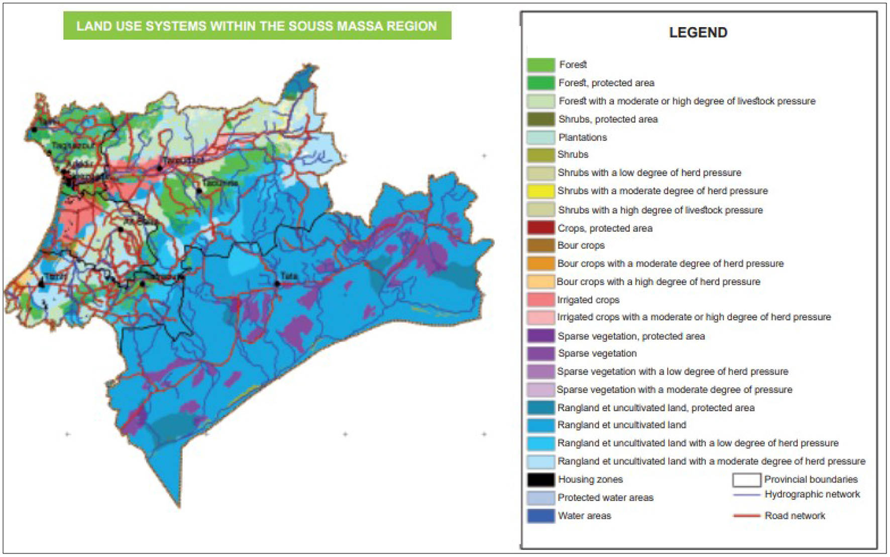
Map of LUS in the Souss-Massa region.
Main types of land degradation
In order to develop the map on the main types of degradation, the parameters such as extent, degree and rate of degradation were first determined. The classification into degradation types was based on the weight of these various parameters. Figure 7 presents the main types of degradation and index of the classification (extent × degree × rate). The degradation types, severity rank and the impacted provinces are presented in Table 1. In the case that more than one type of degradation is present in a LUS, the dominant type is taken into consideration.
Figure 7
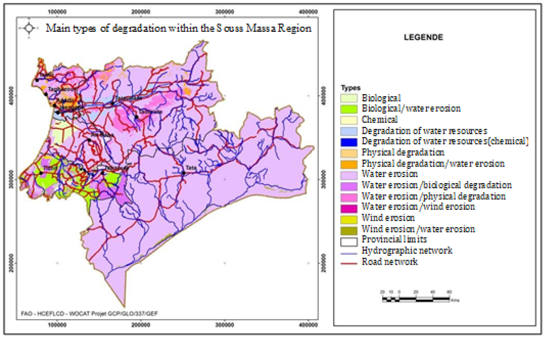
Main types of degradation within the Souss Massa region.
Table 1
| Type of degradation | Area in hectares | Degree of severity |
|---|---|---|
| Soil erosion by water | 4,749,341 | 0.83 |
| Biological degradation (e.g., reduction of vegetation cover, loss in biodiversity) | 282,804 | 0.5 |
| Degradation of water resources (reduced water availability, aridification) | 163,832 | 0.93 |
| Physical degradation (e.g., compaction) | 79,718 | 0.83 |
| Soil erosion by wind | 33,485 | 0.33 |
| Chemical (e.g., loss of fertility and/or organic matter) | 332 | 0.034 |
Area and degree of severity per type of degradation within Souss-Massa region.
Figure 7 and Table 1 show that: (i) soil erosion by water occurs in the region's largest area and shows the second highest severity; (ii) biological degradation occurs in the second largest area; (iii) the degradation of water resources ranked third in terms of area but has the highest degree of severity.
The map of total degradation index or severity obtained by normalizing the product area × degree × rate is shown in Figure 8.
Figure 8
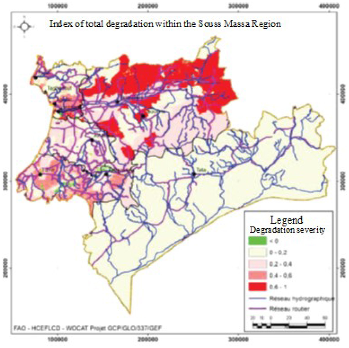
Map showing Index of total degradation or severity in the Souss-Massa region.
Sustainable land management good practices
The most widespread SLM technologies assessed using the LADA-WOCAT mapping methodology are shown in Figure 9.
Figure 9
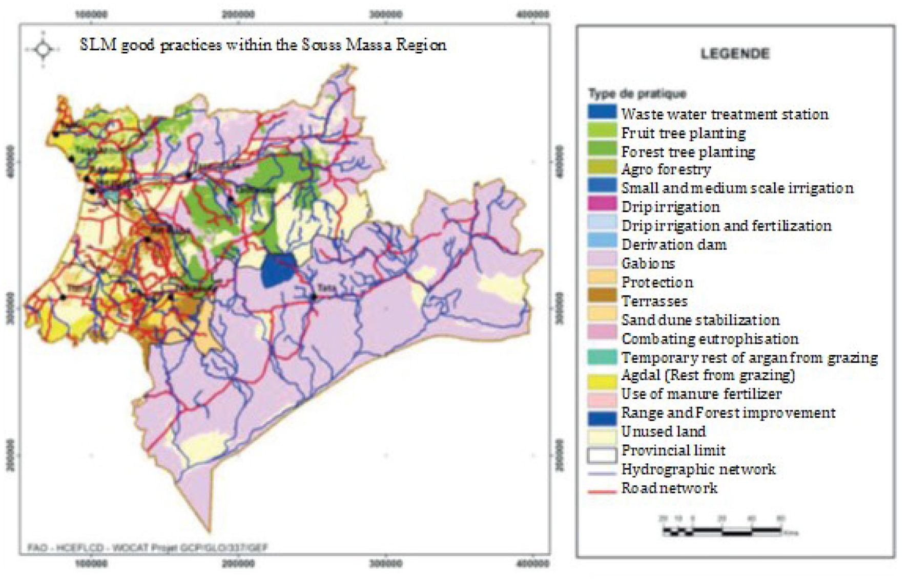
Map of SLM technologies in the Souss-Massa region.
Technologies and Approaches found in the Souss-Massa region and their presence in different provinces are presented in Table 2.
Table 2
| Technology groups | Provinces |
|---|---|
| Agdal (rest) | Agadir-Ida-Outanane and Tiznit |
| Agroforestry | Taroudant |
| Sylvopastoral management (ASP) | Tata |
| Derivation dam | Tata |
| Rest of argan from grazing (May to September) (agdal) | Inezgane-Ait Melloul |
| Sand dune stabilization | Chtouka- Ait Baha, Inezgane-Ait Melloul and Tiznit |
| Use of organic fertilizer | Taroudant |
| Gabions | Taroudant, Tata |
| Drip irrigation and fertilizer | Agadir-Ida-Outanane |
| Localized irrigation | Inezgane- Ait Melloul and Tiznit |
| Combating eutrophisation | Agadir-Ida-Outanane |
| Plantation | Agadir-Ida-Outanane |
| Small and medium sized irrigation areas (PMH) | Tiznit |
| Protection from grazing | Agadir-Ida-Outanane, Chtouka- Ait Baha, Inezgane- Ait Melloul and Tiznit |
| Forest plantation | Agadir-Ida-Outanane Chtouka- Ait Baha, Inezgane- Ait Melloul, Taroudant, Tata and Tiznit |
| Sewage water treatment station (STEP) | Inezgane- Ait Melloul |
| Terraces | Agadir-Ida-Outanane Chtouka- Ait Baha and Tiznit |
SLM technologies and approaches in the Souss-Massa region and the affected provinces.
Findings from landscape/local level assessment
In this paper, we present the main findings from the local level assessment in the commune of Amskroud. Similar analyses were also carried out for the other two communes.
Land use systems
Figures 10, 11 show the land use system map and the contribution of the different LUS categories in the Amskroud commune area.
Figure 10
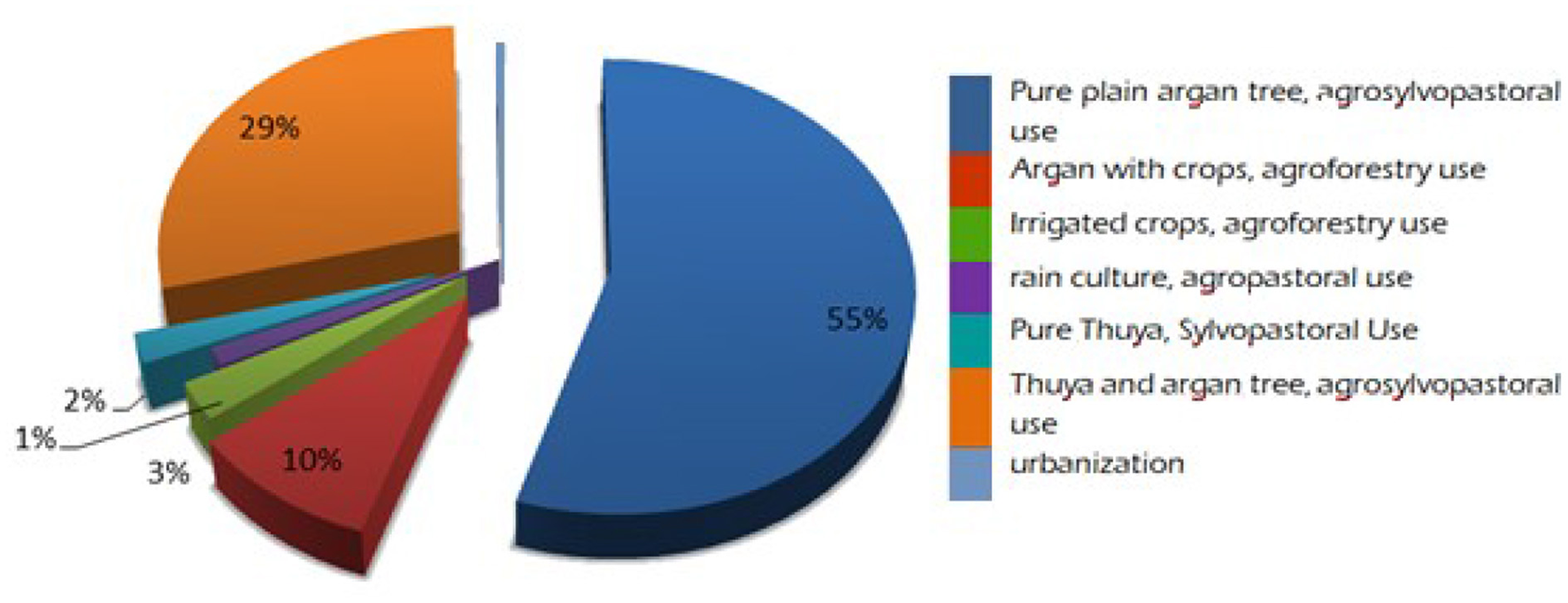
Contribution (percent) of different LUS in Amskroud commune area.
Figure 11
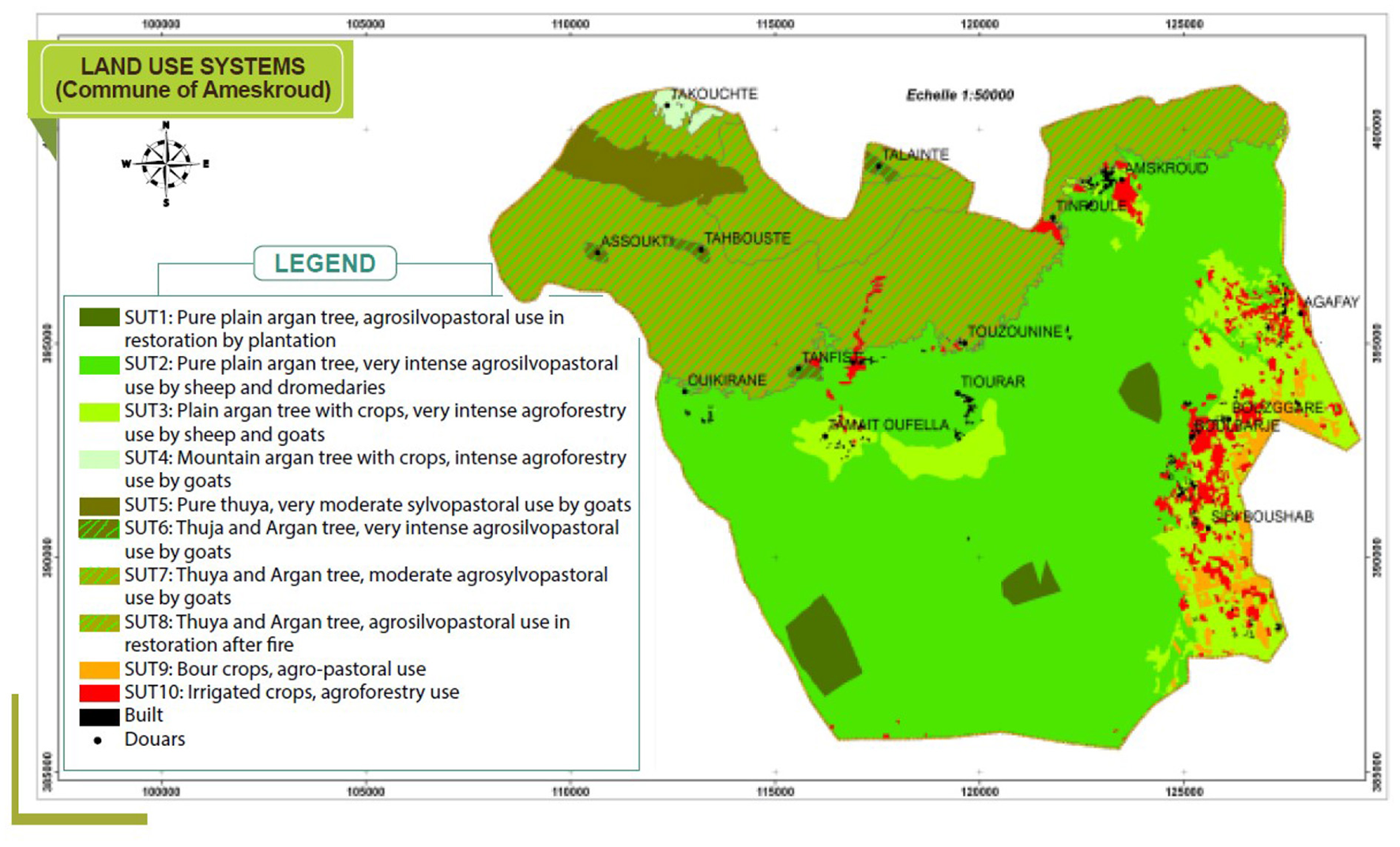
Land use system map of Amskroud.
Pure argan trees (Argania spinosa) located on the Souss plain cover 55 percent of the commune area (Figure 10). This area is intensively grazed by sheep and camels. Within this area, the cultivation of annual crops covers nine percent of the commune area (Figure 11). Thuya (Tetraclinis articulata) mixed with argan trees and used for agrosylvopastoralism is found in the mountain zone and covers 29 percent of the commune territory. This unit was put to rest after the 2013 forest fire. In the mountain zone, a moderate agrosylvopastoral system used by goats covers 24 percent of the commune area.
Socio-economic conditions
To construct the pentagon of capitals, information was gathered on the living conditions of the families participating in the project and a summary was made of the different contributors to livelihoods, such as herd size, farm size, income from farm and other activities, agricultural equipment, formal and informal social networks, and means of mobility. Taking into account the local conditions and dominant activities, a score was assigned to each family for each indicator within the range of 1 to 10 for each capital (financial, human, physical, social and natural). This served as a basis for identifying three social categories: poor, middle class and “comfortable” families.
Livelihoods range are generally dominated by the middle-class category to the poor category with a high vulnerability rate. The information shows deficits in human development, weaknesses in physical and financial assets and insufficient natural and social capitals (Figure 12).
Figure 12
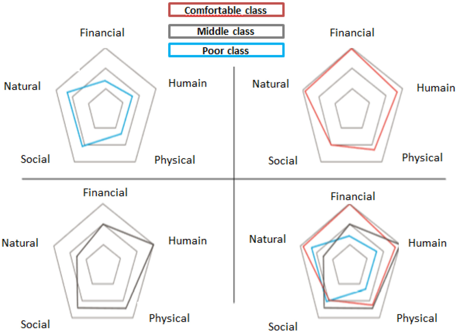
Pentagons of assets according to social groups in the Amskroud commune.
Mapping of SLM good practices
SLM potential solutions were organized into 3 classes:
-
Vegetation and rangelands management practices: agdal practice (rest of argan until fruit harvest), artificial regeneration through planting, regulation of thyme (Thymus satureoides) exploitation;
-
Water resources management practices: matfias (concrete underground water tanks) and iferd (open structure for rainwater harvesting);
-
Soil management practices: Mediterranean terraces, manure application.
For each class, the potential solutions were those that address the type of land degradation identified, with definition of efficiency, the degree of adoption and the constraints that oppose it. For example, the loss of fertility is regulated by the addition of manure. This has a positive effect and is adopted by 90% at the level of the commune. However, the small quantities of manure produced, the limited number of livestock, the poor feed and the lack of manure production capacity in the compound pits suggest that there are still constraints to the adoption of this good practice and its extension to larger areas and communities (Table 3).
Table 3
| Problems of LD | SLM practices | Efficiency (positive, neutral, negative) | Degree of adoption (%) | Constraints related to the adoption of SLM practices |
|---|---|---|---|---|
| Loss of soil fertility | Manure input | Positive | 90 | Low manure production Limited livestock Low livestock feed Lack of ability to manufacture manure (compost pit) |
| Water erosion (groundwater and stripping, gully) and wind (on the coast) | Terrace construction Wall construction Construction of dry stone cords Planting trees and shrubs |
Positive | 50 60 30 80 |
Lack of labor due to migration Land insecurity Poverty Lack of support for small farmers Lack of training (ability) |
| Degradation of vegetation cover | Practice of agdal Sharing and privatization of argan tree stands Conversion from goats to sheep |
Positive | 50 50 80 |
Difficulties to make the rights-holders adhere to the respect of the action Migration |
| Degradation of pastoral potential | Prohibition by the population of the collection of thymus from the mountains. Conversion of goats into sheep. | Positive | 30 80 |
Difficulties to make the rights-holders adhere to the respect of the action |
Adoption of SLM good practices addressing problems of degradation.
Mapping and georeferencing of good practices have also been done. The example below is for agdal within Amskroud commune (Figure 13) and shows areas with and without the agdal SLM practice.
Figure 13
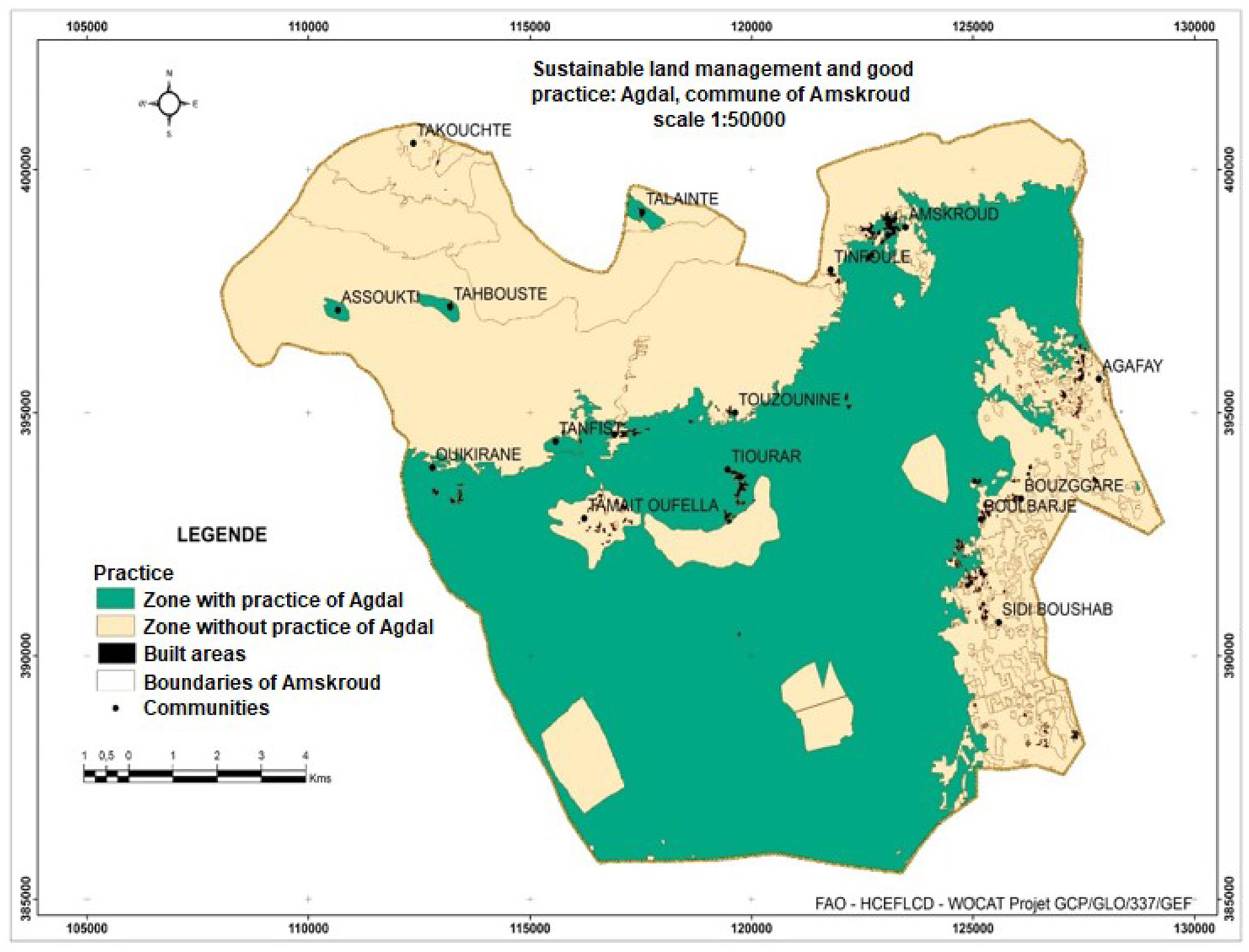
Areas with and without agdal practice within the Amskroud commune.
The Territorial Planning Pact to ensure sustainability of the planning process
Following the data collection process and the presentation of results from the land degradation assessments, a Territorial Planning Pact was developed based on a series of consultations with institutional parties, local authorities and development associations as well as representatives from the three communes (Berkat, 2019). For each commune, institutions were tasked with the implementation of specific agricultural practices. The consultations resulted in securing financial and technical commitment from stakeholders by taking into account the priorities of each commune. The agreed activities for SLM good practices in the Amskroud commune are presented in Table 4. All parties have agreed to abide by the responsibilities entrusted to them to implement the agreement on a voluntary basis and work continuously to overcome obstacles and difficulties during implementation to achieve sustainable land management and neutralize the impact of land degradation.
Table 4
| Good practices | Quantity | Responsible institution | Partners |
|---|---|---|---|
| Repair of stands | 50 ha | Agriculture | Civil society and private associations |
| Setting up new terraces | 50 ha | Agriculture | Civil society and private associations |
| Regeneration of argan trees with fencing | 300 ha | Water and forest | Civil society |
| Herding the pastures | 100 ha | Water and forest | Civil society |
| Establishing protective barriers | 30,000 m3 | Water and forest | Civil society and territorial communities |
| Untangle the isolation | Road opening of 18 km and maintenance of 4 km | Territorial Communities Water and forest | Civil society |
| Iferd | 3 Units | Water and forest-Souss-Massa Hydraulic Basin Agency (ABHSM) | Territorial communities and civil society |
| Local watering | 9 villages | Regional Office for Agricultural Investment (ORMVA) | Civil Society and the private sector |
Agreed activities under the Territorial Planning Pact in Amskroud commune.
The purpose of the pact is to identify the priority interventions and the responsibilities of various stakeholders, including government institutions and communities. This is to ensure proper implementation of the SLM practices and to avoid/minimize conflicts between communities and sectors. It also enhances governance of resources and sustainability of the land use planning efforts.
It is useful to mention that most of the actions agreed in the pact are the responsibility of the water and forest department. The implementation of these actions is satisfactory. Water and forest managers always think of consulting the pact to plan their actions by leading consultations with associations representing the beneficiary population. However, emergencies such as the COVID-19 pandemic, impacted the implementation of actions. On one hand, it impacted the ability to organize consultation meetings and workshops to review the implementation, and on the other hand, hampered actions in the field. Yet, the commitment of different stakeholders, through their agreement on the pact is a fruitful outcome. It is vital to maintain the momentum and continue the efforts to enhance the implementation of the agreed pact on a voluntary basis and work continuously to overcome obstacles and difficulties that may face implementation to achieve sustainable land management and neutralize the impact of land degradation.
The 3-year action plan
Based on the Territorial Planning Pact, a 3-year action plan was developed to integrate SLM at provincial level. The development of the action plan drew on results from the assessments and the several consultation processes.
The goal of the 3-year action plan is to fight land degradation by integrating soil, vegetation and water management practices in the communes of Agadir-Ida-Outanane. The strategy of action aims at:
-
Building capacity and promote awareness of stakeholders;
-
Mitigating the effects of water erosion;
-
Improving vegetation cover and management;
-
Promoting the sustainable management of water resources.
To achieve those outcomes, six major areas of actions were agreed:
-
Capacity building and communication for SLM integration in Territorial Planning Plans;
-
Promotion of sustainable land management good practices;
-
Promotion of good practices for sustainable management of vegetation cover;
-
Access to roads;
-
Promotion of sustainable water management practices;
-
Monitoring and evaluation.
The cost of the 3-year action plan is estimated at MAD 180 565 000 (1 MAD = 0.11 USD). The details on the selected good practices in the study areas are listed in Annex A.
Concluding remarks
The study aimed at assessing land degradation (LD) and sustainable land management (SLM) practices for optimal planning and use of natural resources in Souss-Massa region of Morocco. In order to support informed decision-making processes, the Decision Support Framework (DSF) for mainstreaming and scaling out of SLM was applied and tailored to suit specific conditions and needs in Morocco. The LADA–WOCAT methodology and tools were used to evaluate LD and SLM at subnational and landscape/local levels together with the documentation of SLM technologies and approaches. The results of the assessments clarified the pressures and impacts of land degradation, which were used to guide participatory SLM planning in three selected communes in the region. The process led to the development of a “Territorial Planning Pact,” designed to help authorities and decision-makers mainstream, scale out, and implement SLM in the communes and to guide similar processes throughout the region. It is worth underlining that when compared to previous land resources projects, the approach adopted in this study stands out with specific attributes and results. The lessons learned from the process include: (i) extending of the participatory approach (from the phase of resources assessment to concluding the Territorial Planning Pact agreed by stakeholders), which is key to ensure ownership, cross sectoral synergies and sustainability; (ii) exchanges of views and knowledge through meetings, workshops and field visits thus improving awareness of different stakeholders, particularly local communities, of LD issues, and to methods of assessment of this degradation, as well as opportunities to undertake SLM. Stakeholders, including community representatives, benefited from capacity strengthening adapted to their needs; (iii) both biophysical and socio-economic assessments (including community livelihood capitals and needs, good land management practices), in this case allowed through the use of the LADA-WOCAT methodology, are important prior to implementing the territorial negotiation process for the land resources planning, which support the decisions regarding the sustainable use and management of resources to enhance food security and sustainability.
The study highlighted the importance of integrating both biophysical and socio-economic information in a multi-level participatory process to identify the actions and responsibilities of various stakeholders in advancing the implementation of sustainable land and water management and enhance resources management. The study highlighted the importance of integrating the evaluation of good practices into the programs and to eliminate the obstacles at the different levels to enhance the implementation of the sustainable management of water and land, to combat land degradation and enhance food security and livelihoods of the target communities. Similar approach could be implemented in Morocco and worldwide to support the sustainable management of limited resources and enhance productivity and livelihoods of local communities.
Publisher's note
All claims expressed in this article are solely those of the authors and do not necessarily represent those of their affiliated organizations, or those of the publisher, the editors and the reviewers. Any product that may be evaluated in this article, or claim that may be made by its manufacturer, is not guaranteed or endorsed by the publisher.
Statements
Data availability statement
The original contributions presented in the study are included in the article/Supplementary material, further inquiries can be directed to the corresponding author.
Author contributions
FZ: lead the conception and design of the work, analysis and interpretation of data, and drafting the work and organizing the revision of the work for important intellectual content. OB: substantial contributions to the design of the work, acquisition and interpretation of data, and contribution to drafting the work and revising it critically for important intellectual content. RO: substantial contributions to the design and implementation of the work, the acquisition and analysis of data, and contribution to drafting the work. MT: contributions to the implementation of the field work. TF: substantial contributions to the conception and design of the work, contribution to drafting the work, and revising it critically for important intellectual content. NH: revising the work. RS: contribution to drafting the work and revising it critically for important intellectual content. SS: contributions to the conception and implementation of the work. All authors contributed to the article and approved the submitted version.
Acknowledgments
The authors would like to acknowledge the contribution of Mohamed Sabir, Late Mohamed Qarro, Mohamed Rouchdi, and Zoubir Chattou who established and conducted assessments of land degradation and good practices in sustainable land management, Monica Petri who piloted the subnational mapping of hot spots and bright spots, Hedi Hamrouni and Donia Jendoubi for introducing the local level assessment to the national stakeholders. The DS-SLM project is funded by the Global Environment Facility (GEF).
Conflict of interest
The authors declare that the research was conducted in the absence of any commercial or financial relationships that could be construed as a potential conflict of interest.
Supplementary material
The Supplementary Material for this article can be found online at: https://www.frontiersin.org/articles/10.3389/fsufs.2022.848043/full#supplementary-material
Footnotes
1.^ https://www.agriculture.gov.ma/fr/region/souss-massa
2.^ https://www.soussmassa.ma/en/agriculture
3.^ Land Degradation Assessment in Drylands (LADA), https://www.fao.org/land-water/land/land-assessment/assessment-and-monitoring-impacts/en/.
4.^ World Overview of Conservation Approaches and Technologies (WOCAT), https://www.wocat.net/en/.
5.^ https://qcat.wocat.net/en/wocat/list/?type=wocat&filter__qg_location__country=country_MAR&filter__qg_funding_project__funding_project=
References
1
ADA (2021). Main Achievements of the Green Morocco Plan. Available online at: https://www.ada.gov.ma/en/main-achievements-green-morocco-plan
2
Bastidas Fegan S. (2019). The DS-SLM Sustainable Land Management Mainstreaming Tool-Decision Support for Mainstreaming and Scaling up Sustainable Land Management. Rome: FAO, 44. Licence: CC BY-NC-SA 3.0 IGO. Available online at: https://www.wocat.net/library/media/170/
3
Berkat O. (2019). Elaboration d'un plan d'action pour l'intégration et la transposition de la GDT au niveau de la province d'Agadir- Ida-Outanane. FAO Projet GCP/GLO/337/GEF. ‘Aide à la décision pour l'intégration et la transposition à grande échelle de la gestion durable des terres'.
4
Bunning S. McDonagh J. Rioux J. (2016). Manual for Local Level Assessment of Land Degradation and Sustainable Land Management. Rome, Italy: FAO.
5
Custović H. Ljuša M. Schlingloff S. (2020). Sustainable land management–approaches and practices in Bosnia and Herzegovina. University of Sarajevo. Available online at: https://www.wocat.net/library/media/240/
6
De Vente J. Reed M. S. Stringer L. C. Valente S. Newig J. (2016). How does the context and design of participatory decision making processes affect their outcomes? evidence from sustainable land management in global drylands. Ecol. Soc. 21, 24. 10.5751/ES-08053-210224
7
FAO (2005). Participatory and negotiated territorial development (PNTD). Available online at: http://hubrural.org/IMG/pdf/fao_pe2_050402d1_en.pdf
8
FAO (2017). Land resource planning for sustainable land management. Rome, 68. Available online at: http://www.fao.org/3/a-i5937e.pdf
9
FAO (2018). “Land resources planning toolbox.” in: FAO Land and Water. Available online at: http://www.fao.org/land-water/land/land-governance/land-resources-planning-toolbox/en/
10
FAO (2019). Climate Smart Agriculture Sourcebook, Module 7. Available online at: http://www.fao.org/climate-smart-agriculture-sourcebook/production-resources/module-b7-soil/chapter-b7-1/en/
11
FAO (2022a). The State of the World's Land and Water Resources for Food and Agriculture – Systems at breaking point. SOLAW Main report. Rome.
12
FAO (2022b). The State of Land and Water Resources for Food and Agriculture (SOLAW) for the Near East and North African (NENA).
13
Harari N. Garcia C. Teich I. Caza P. Ljusa M. Custovic M. et al . (2022). Integrating Land Degradation mapping into Sustainable Land Management decision-making to reach Land Degradation Neutrality. To be published in LDandD special issue “Land Degradation and Desertification mapping and Land Degradation Neutrality (LDN) targets”.
14
Liniger H. Harari N. van Lynden G. Fleiner R. Leeuw de J. Zhanguo W. et al . (2019). Achieving land degradation neutrality: the role of SLM knowledge in evidence-based decision-making. Environ. Sci. Policy.94, 123–34. 10.1016/j.envsci.2019.01.001
15
Liniger H. van Lynden G. Nachtergaele F. Schwilch G. Biancalani R. (2013). Questionnaire for mapping land degradation and sustainable land management (QM) Version 2. Food and Agriculture Organization of the United Nations (FAO). Available online at: https://www.fao.org/3/i3240e/i3240e.pdf
16
MAPM (2008). Plan Maroc Vert. Présentation générale. Ministère de l'Agriculture et des Pêches Maritimes. Rabat, Morocco.
17
MAPMDREF (2021). Morocco Country Strategy and Programme Evaluation. Available online at: https://www.ifad.org/en/web/ioe/-/morocco-country-strategy-and-programme-evaluation-virtual-national-workshop
18
Montanarella L. Scholes R. Brainich A. (eds.) (2018). The IPBES assessment report on land degradation and restoration. Secretariat of the Intergovernmental Science-Policy Platform on Biodiversity and Ecosystem Services. Bonn, Germany, 591–648.
19
Nachtergaele F. Petri M. (2013). Mapping Land Use Systems at global and regional scales for Land Degradation Assessment Analysis Version 1.0. Rome, Italy: FAO.
20
Petri M. Biancalani R. Lindeque l. (2019). Guidelines for the national assessment and mapping of land degradation and conservation. FAO: Rome, 52. Licence: CC BY-NC-SA 3.0 IGO.
21
Rouchdi M. Sabir M. Qarro M. Chattou Z. (2018). Degradation assessments and good sustainable land management practices within and through their systems of use, “Souss-Massa region / permanent ecological monitoring and surveillance observatories”. Project Report, Rabat, Morocco.
22
Sabir M. Qarro M. Chattou Z. Rouchdi M. (2017). Evaluations de la dégradation et des bonnes pratiques de gestion durable des terres au sein et à travers leurs systèmes d'utilisation. Région Souss-Massa/observatoires permanents de suivi et de surveillance écologique. Rapport de synthèse. Volume I.
23
Schwilch G. Bachmann F. Liniger H. P. (2009). Appraising and selecting conservation measures to mitigate desertification and land degradation based on stakeholder participation and global best practices. Land Degrad. Dev.20, 308–326. 10.1002/ldr.920
24
Schwilch G. Bestelmeyer B. Bunning S. Critchley W. Herrick J. Kellner K. et al . (2011). Experiences in Monitoring and Assessment of Sustainable Land Management. Land Degrad. Develop. 22, 214–225. 10.1002/ldr.1040
25
Turner K. G. Anderson S. Gonzales-Chang M. Costanza R. Courvillef S. Dalgaard T. et al . (2015). A review of methods, data, and models to assess changes in the value of ecosystem services from land degradation and restoration. Ecol. Model. 319, 190–207. 10.1016/j.ecolmodel.2015.07.017
26
UNCCD (2013). Desertification, land degradation and drought (DLDD)–some global facts and figures. Bonn: United Nations Convention to Combat Desertification.
27
UNDESA (2021). Global SDG Indicators Database. UN Department of Economic and Social Affairs. Available online at: https://unstats.un.org/sdgs/indicators/database/
28
Van Haren N. Fleiner R. Liniger H. Harari N. (2019). Contribution of community-based initiatives to the sustainable development goal of Land Degradation Neutrality. Environ. Sci. Policy. 94, 211–219. 10.1016/j.envsci.2018.12.017
29
Willemen L. Nangendo G. Belnap J. Bolashvili N. Denboba M. A. Douterlungne D. et al . (2018). “Chapter 8: Decision support to address land degradation and support restoration of degraded land.” in The IPBES assessment report on land degradation and restoration (Bonn: Intergovernmental Science-Policy Platform on Biodiversity and Ecosystem Services).
30
WOCAT (2016). Questionnaire on SLM Approaches. Available online at: https://www.wocat.net/library/media/16/
31
WOCAT (2019). Questionnaire on SLM Technologies. Available online at: https://www.wocat.net/library/media/15/
32
WOCAT (2022). Global SLM Database. Available online at: https://www.wocat.net/en/global-slm-database/; https://qcat.wocat.net/en/wocat/
33
WRI (2014). “Atlas of forest and landscape restoration opportunities.” in: WRI Maps and Data (World Resource Institute). Available online at: https://www.wri.org/resources/maps/atlas-forest-and-landscape-restoration-opportunities
34
Ziadat F. Mazahreh S. Haddad M. Benabdelouahab T. Attaher S. Karrou M. et al . (2014). Similarity and Suitability Analysis to Assist the Out-Scaling of Sustainable Water and Land Management Practices in West Asia and North Africa. Research Report, 11, Beirut, ICARDA.
Summary
Keywords
land degradation, sustainable land management, participatory territorial planning, decision support framework, Territorial Planning Pact
Citation
Ziadat F, Berkat O, Ouchna R, Touami M, Fetsi T, Harari N, Studer RM and Schlingloff S (2022) Participatory land resources planning to promote sustainable landscape management in rainfed areas-Morocco. Front. Sustain. Food Syst. 6:848043. doi: 10.3389/fsufs.2022.848043
Received
03 January 2022
Accepted
19 July 2022
Published
18 August 2022
Volume
6 - 2022
Edited by
Olcay I. Unver, Arizona State University, United States
Reviewed by
Redouane Choukrallah, International Center for Biosaline Agriculture (ICBA), United Arab Emirates; Luuk Fleskens, Wageningen University and Research, Netherlands
Updates
Copyright
© 2022 Ziadat, Berkat, Ouchna, Touami, Fetsi, Harari, Studer and Schlingloff.
This is an open-access article distributed under the terms of the Creative Commons Attribution License (CC BY). The use, distribution or reproduction in other forums is permitted, provided the original author(s) and the copyright owner(s) are credited and that the original publication in this journal is cited, in accordance with accepted academic practice. No use, distribution or reproduction is permitted which does not comply with these terms.
*Correspondence: Feras Ziadat feras.ziadat@fao.org
This article was submitted to Water-Smart Food Production, a section of the journal Frontiers in Sustainable Food Systems
Disclaimer
All claims expressed in this article are solely those of the authors and do not necessarily represent those of their affiliated organizations, or those of the publisher, the editors and the reviewers. Any product that may be evaluated in this article or claim that may be made by its manufacturer is not guaranteed or endorsed by the publisher.