 Elias D. Kuusaana
 Isaac Ayurienga
 Joyce A. Eledi Kuusaana
 Joseph K. Kidido
 Ibrahim A. Abdulai
- 1Department of Land and Geoinformation Management, SD Dombo University of Business and Integrated Development Studies, Wa, Ghana
- 2Public and Vested Land Management Division, Lands Commission, Bolgatanga, Ghana
- 3Research Training Group on Critical Infrastructures (RTG-KRITIS), Technical University of Darmstadt, Darmstadt, Germany
- 4Department of Land Economy, Kwame Nkrumah University of Science and Technology, Kumasi, Ghana
- 5Department of Governance and Development Management, SD Dombo University of Business and Integrated Development Studies, Wa, Ghana
Increasingly, urban land use planning is getting more complex as limited urban spaces are continuously allocated among diverse land uses. From previous urban food system studies in Ghana, it has become apparent that large portions of urban land parcels are unsustainably converted to urban infrastructure. Hence, the sustainability of the food system is significantly threatened by inefficient spatial and infrastructure planning mechanisms that fail to protect urban agricultural zones. Of critical concern is the fact that agricultural land use allocations on planning schemes are easily converted to residential uses under demand driven expropriations. In that respect, this study was undertaken in the Bolgatanga Township to understand how urban dwellers sustain urban agricultural practices within the city. Using field surveys, key informant interviews and GIS mapping, the study found that, the total sizes of agricultural lands have decreased significantly since 1996 as urban Bolgatanga began sprawling from the inner city through to the urban fringes. In the process, agricultural lands have decreased in terms of both size and contiguity at the household level, compelling farmers to create multiple segregated farmlands within residential neighborhoods in the form of compound farms or fenced urban gardens. Hence, some urban farmers continue to rely on undeveloped residential plots and open public spaces in the inner city for production, but they easily lose these as developments in residential neighborhoods intensifies. From the physical development pattern of the city, we conclude that urbanization in agrarian cities will exacerbate the challenges of food production if relevant policy interventions are unavailable to provide for and protect agricultural lands. The study recommends that, food-inclusive planning schemes should be the basis of future physical plans to guide land uses in the peri-urban and rural zones. This will require both political will and community consensus building on the necessity to preserve urban agricultural space to sustain food supply.
Introduction
Urban agriculture occupies a special economic niche and offers food and livelihood opportunities for a section of urban population especially urban poor. Importantly, it is critical to ensuring urban food security and attainment of the sustainable development goals; zero hunger (SDG 2) and sustainable cities and communities (SDG 11). However, the sustainability of this enterprise faces serious threat from rapid urbanization, spatial and regulatory lapses in urban planning and development process. According to Rakodi (1997:1) “it is almost a truism that the planet's future is an urban one, and that, the largest and fastest growing cities are primarily in developing countries.” Already the effects of rapid urbanization in developing countries are manifesting in urban sprawl, socio-economic inequities, environmental degradation, and institutional challenges for urban residents and local authorities (Owusu and Lawrence, 2010; Anarfi et al., 2020). Even though governments have tried to tackle some of these emerging challenges through institutional and legislative reforms, very little has been achieved due to implementation bottlenecks. Coulibaly and Li (2020) and Aguilar and Ward (2003) indicated that rapid urban population growth has led not only to an increasing demand for urban land for residential purposes, but also for other urban uses.
In many parts of the world, there is spatial expansion, intensification and peripheralization of urban land (see Aberra and King, 2005; Kuusaana and Eledi, 2014, 2015a; Follmann et al., 2021). Urban areas in Africa have seen heterogeneous populations engaging in different land uses within its peri-urban enclaves (see Thuo, 2010). Urban areas have transformed greatly into non-agricultural uses due to urban population growth dynamics (see Chirisa, 2010; Coulibaly and Li, 2020). Food supply from the urban space faces potential collapse with attendant food security problems for urban households. For instance, Lyons et al. (2013), have noted that the growth in urban populations presents formidable challenges toward addressing potential food crisis that confront the world. They opined that in Australia for instance, there are growing concerns about sustainability of urban agricultural systems into the future and ability to continue to supply food to the growing population. They again noted that urban planners are strategically placed to contribute toward alleviating growing food security challenges through urban space creation for food production. Since there are concerns about environmental and socio-political limits to contemporary industrial food systems (Lyons et al., 2013), it is critical to project urban food production as a critical anchor to tackling global food security challenges.
Rapid urbanization has multiple impacts on urban land use as well as the livelihoods of peri-urban communities (Aberra and King, 2005; Mohammed et al., 2020). This is because it is inextricably intertwined with the rural fringes where urban growth encroaches on agricultural lands and the surrounding rural residents (Gantsho, 2008; Thuo, 2010; Coulibaly and Li, 2020; Mohammed et al., 2020). Thus, growth in urban population increases population densities within established urban and per-urban areas (Mandere et al., 2010). This means that urbanization transforms peri-urban settlements from simple patches of villages with rural lifestyles to a more complex, partly urban lifestyles (Edusah, 2008; Osumanu et al., 2018; Mohammed et al., 2020). A key challenge to the urbanization process is the rapid conversion of large amount of prime agricultural land in the urban periphery to urban housing, thereby creating a viable land market that escalates rural land prices (Owusu and Agyei, 2007; Gantsho, 2008; Osumanu et al., 2018; Akaateba, 2019; Czekajlo et al., 2021) and transforms them from hitherto gratuitous grants to highly commercialized transactions (see Kuusaana, 2016).
It is observed that the natural physical environment suffers greatly from peri-urban population growth (Chirisa, 2010; Mohammed et al., 2020). For instance, the extension of the urban corridors significantly reduces available productive land and encroaches upon important ecosystems (UNFPA, 2007). Peri-urbanization leads to farmland decline as rapid urban expansion consume peri-urban lands and creates productive land scarcity as non-farm activities increase land values (Abass et al., 2018). It breeds poverty among urban residents, triggers land fragmentation, creates unemployment and neighborhood conflicts, and disrupts traditional livelihoods (Abass et al., 2018; Abdulai et al., 2020). In the peri-urban area, the process of land use conversion from agricultural to residential, commercial, and industrial uses, goes hand in hand with transformations in the livelihoods of different groups—with the poorest often losing out (Tacoli, 2004). Whilst the wealthy can shed off rural attitudes in response to urban challenges, the poor in peri-urban areas are slow in doing so (CEDEP, 2005). It is worth noting that, urbanization does not only pose a constraint to urban poor living on urban fringes, but it may also create numerous opportunities as well. For instance, urbanization creates opportunities in wage employment, trade diversity, and provides them with improved access to urban services and infrastructure (Aberra and King, 2005; United Nations, 2019) if its dynamics are properly management. On the contrary, it can also result in unemployment, poor social amenities, escalation of crime, loss of social safety nets among others. As infrastructure and social amenities in urban areas improve, these areas are consequently transformed into complex monetised urban economies and integrated into the urban enclave (Aberra and King, 2005; Adu-Ampong et al., 2008). Consequently, urban land use changes from agricultural to non-agricultural uses can result in livelihood diversification across the different social classes.
In Ghana, Metropolitan, Municipal and District Assemblies (MMDAs) are tasked to spearhead urban development planning and to address urban challenges relating to urban and peri-urban livelihoods, governance, social service, infrastructure development, poverty alleviation, minimizing environmental degradation and urban security (see Annez et al., 2010; UN-Habitat, 2010). However, the lack of funding creates difficulties for the MMDAs in executing this mandate (Hackman et al., 2021). Though there have been numerous geographical studies on rural-urban linkages, particularly effects of urbanization on rural socio-economic and ecological systems (Aguilar and Ward, 2003; Tacoli, 2004; Aberra and King, 2005; Adu-Ampong et al., 2008; Kuusaana and Eledi, 2014, 2015a; Coulibaly and Li, 2020) few studies have examined the household level impacts of urbanization and how urban farmers sustain agricultural practices amid growing land scarcity. In addition, previous studies have laid emphases on uncontrolled urbanization and its livelihood implications (Aberra and King, 2005; Adu-Ampong et al., 2008; Appiah et al., 2014), its concerns for food systems (Kuusaana and Eledi, 2014) and food security (Bonye et al., 2021), determinants of peri-urbanization and land use change patterns in peri-urban Ghana (Appiah et al., 2014; Fuseini et al., 2017; Kleemann et al., 2017; Abdulai et al., 2021). However, few studies have explored the sustainability dynamics of urban agriculture in the wake of rapid urban expansions and population growth trajectories in the Bolgatanga area of the savannah ecological zone of Ghana. Even though Tacoli (2004) has emphasized that urbanization leads to the transformation of livelihoods among different groups, agricultural, residential, and commercial land uses continue to co-exist in many cities of developing countries. However, the dearth of holistic studies on how the peri-urban households cope with the growing land scarcity and underlining sustainability challenges impede sound appreciation of urban agriculture and food supply discourse, and the opportunities that urbanization presents.
As urbanization increases pressure on urban land, water, and labor supply systems (see Thebo et al., 2014; Zoomers et al., 2017), it is important to integrate urban and peri-urban agriculture into urban land use planning (Kleemann et al., 2017; Bonye et al., 2020; Nicholls et al., 2020). It is expected that to be able to keep urban and peri-urban agricultural lands consistently relevant, it is imperative to properly understand how to integrate them into urban land use planning (Bates et al., 2014; Cortinovis and Geneletti, 2018). This will prevent urban farmers from continuing to operate informally (Orsini et al., 2020) and on unauthorized public lands (see Kuusaana and Eledi, 2015a).
Agricultural activities in urban areas in Africa have been affected resulting in output reduction, reduction in farm size and farm output losses due to increasing land use changes emanating from city's outward expansion and the peripheralization of agriculture (see similar studies are Drechsel and Dongus, 2010 in Tanzania; Vermeiren et al., 2013 in Uganda). The Bolgatanga Municipality (in Ghana) is used as a case study because urban peasants have sustained urban agriculture within the Town notwithstanding the competition with non-agricultural land uses and the urban development complexities. Since such indigenous urban-poor peasants are recognized as a special category of vulnerable groups (Maxwell et al., 2000), it is imperative to empirically understand the urban characterization of Bolgatanga and how land use changes are affecting peri-urban peasants' access to land and identify sustainable options for urban agricultural activities. The study also addresses the question of how urban farmers respond to urban growth dynamics amidst existing spatial challenges (see Follmann et al., 2021). Hence, this study combines both the spatial dynamics and the multiple complexities and interlinkages of urban agriculture to understand the transformations and responses of urban and peri-urban farmers under urban growth. These discussions are relevant for both planning practice and policy formulation that are anchored on consultative approaches. Integrating urban agriculture into sustainable urban development framework is critical to the attainment of sustainable development goals especially considering the livelihood connections of the urban poor to urban agriculture economy (see Follmann et al., 2021).
The next section of the paper reviews literature on the nexus between urban farmer population dynamics and land use to establish the theoretical linkages of urbanization and its impacts on the urban population especially urban food systems, land use change and food production under customary land tenure settings. Section discusses the study area location, land tenure system and urban growth patterns. This is followed by the research methodology—materials and methods. Data presentation, analysis and discussions are contained in section five, while conclusion and recommendations constitute section six.
Multiple Impacts of Peri-Urbanization: Food Systems, Food Production and Land Use Change
For most of Africa, peri-urbanization is characterized as unprecedented informal urbanization of poverty (Kombe, 2005; Atu et al., 2013) through out-migration of urban inhabitants to escape from urban policies harassment (Lupala, 2002). Angel et al. (2005) indicates that peri-urbanization in Africa leads mainly to horizontal growth of towns and encroachment on farmlands and rural communities. While it is not accompanied by tangible economic growth and buoyant secondary activities as recorded in many African cities, peri-urbanization substitutes agricultural land uses (Spence et al., 2009). Global urban expansion revealed that cities in developing countries have three times the population density of cities in developed countries (see Angel et al., 2005; United Nations, 2019). Today, the largest and fastest-growing cities in the world are in southern countries i.e., Africa, Asia, Central and South America. Despite the general decline in population growth rates since the mid-1980s, Africa remains the world's fastest-growing region (Kaba, 2020) with expectation that its built-up area will triple, while the population doubles (see Angel et al., 2005; Kaba, 2020; Zimmer et al., 2020). Even in African cities with smaller densities, urban sprawl remains a major concern for urban residents and local governments (Otoo et al., 2006; Yankson, 2006) because of unique urban form, historical growth patterns and customary tenure systems of landholding (see Akaateba, 2019; Akaateba et al., 2021). For many smaller cities, migration remains a major source of population growth (Olima, 2003).
In Ghana, urban population growth rate of about 4.3% has outstripped the overall national population growth rate of about 2.1% (Ghana Statistical Service, 2002; 2021; UNFPA, 2007). This rapid rate of urbanization in Ghana represents a major redistribution of population, with significant implications for national development. The share of urban population is also higher in Ghana than in the West African region, where in 2010 about 42% of the West African population lived in urban areas (OECD, 2018).
Even though urban agriculture has not received significant policy attention in Ghana and in many developing countries, the practice flourishes in the developed countries where several conditions are favorable (Sroka and Pölling, 2015) as an employer and a source of food. De Bon et al. (2010) argue that urban agriculture could provide employment opportunities for the teaming unemployed youth in urban areas. Urban agriculture also has the potential to provide city markets with fresh fruits and vegetables, reduce the urban waste, as well as improve urban biodiversity (Orsini et al., 2020). Mariwah and Drangert (2011) have earlier argued that urban agriculture provides opportunity for the use of urban household waste such human excreta to improve crop yield and enhance food security among urban households and the larger city. The importance of urban agriculture therefore makes it imperative for planning authorities to consider it as a planning problem in urban planning schemes in Ghana and in similar contexts across the sub-region.
Peri-urban land is of capital importance in modern societies because it pivots all the dynamics of societal transformations (see Follmann et al., 2021). Urban expansion and the competition for land may also result in changes in land use, ownership, property rights regime, and land tenure (Wehrmann, 2008). Thus, peri-urban areas are the center of almost all formal and informal developments such as new urban expansion and decline of agricultural lands and rural employment opportunities (Payne, 1997; Allen, 2003; Lerise et al., 2004). Land use changes are foremost among changes occurring in the peripheral cities (Tacoli, 2004). Furthermore, Owusu (2008) observed that the process of peri-urbanization has successively changed the land use patterns in the peri-urban areas in Ghana. According to Appiah et al. (2014) the decision to convert land from agricultural uses to residential and commercial uses are driven by many [f]actors, including social and economic. Lambin et al. (2003) reported that land use changes are primarily influenced by changes in demography, policies, economic and political or at times a combination of these factors. Webster and Muller (2002) stresses on the economic rationality of peri-urban landowners as the key driver of peri-urbanization. Accordingly, higher economic gains from land conversion and transformation to other non-agricultural uses, motivate landowners to opt for the higher future returns on their land (Irwin and Geoghegan, 2001) and may speculate on the land (Satterthwaite et al., 2010). This incentive makes some customary landholders to alter the available land use plans to create non-existent “sellable” spaces for urban infrastructure (Adriana, 2003; Yeboah and Shaw, 2013). For instance, in the stool land areas in Ghana, the decision to convert agricultural land to non-agricultural uses in the peri-urban enclaves are influenced largely by economic incentives (see Kasanga et al., 1996; Kidido and Bugri, 2020; Kidido, 2021) and executed by chiefs and other traditional local actors. The changing land use patterns, to a large extent, have significant consequences on peri-urban land use decisions (Kombe, 2005; Dutta, 2012; Appiah et al., 2014), and deepens informal land tenure struggles (Haller, 2014; Cobbinah et al., 2015; Schmidt et al., 2015).
The need to produce adequate food to feed the rising regional populations makes the issue of food production within the urban space a crucial matter. Shields (2013: p. 6) cites two main forces which accompany the issue of urbanization: increase in the population on a concentrated space and the resultant decrease in the cultivable land available. This is inevitable to some extent, as civilisations have thrived in areas with high soil fertility as well as the availability of freshwater resources (Satterthwaite et al., 2010). The FAO (2011) believes that sustainable intensification is the best way to produce enough food to feed urban dwellers. For example, according to Robineau and Dugu (2018) farmers adapt farmland intensification practices to utilize diminished farmlands and to compensate for their losses. While the issue of boosting food production remains critical, there also appear to be some concerns about the environmental impact of agriculture resulting from intensification due to the usage of chemical fertilizers, pesticides as well as irrigation technologies (Shields, 2013: p. 6; Pinstrup-Andersen and Pandya-Lorch, 1994). However, the reverse is also problematic in which case urban industrial activities could pollute the soil and water, thus making urban agricultural produce unsafe for consumption. Also, urban flooding can pollute water sources and urban farmlands (McLees, 2011). The FAO (2011) advocates for a strong connection between rural and urban areas to ensure adequate food production by their combined agricultural practices (see also Bricas et al., 2003).
Study Area Description—Location, Land Tenure Systems and Urban Growth
Location and Land Tenure System
The study was undertaken in the Bolgatanga Township within the Bolgatanga Municipality of the Upper East Region of Ghana. The Upper East Region is in the north-eastern corner of Ghana with a total landmass of approximately 8,842 square kilometers representing 3.7% of the total land mass of the country. Bolgatanga is the capital city of the Upper East Region, and it is located within the Bolgatanga Municipality. The Municipality was created in 2004 under the Legislative Instrument (L.I.) 1797 and is located at the heart of the Region. The Bolgatanga Municipality has a total landmass of about 444 square kilometers. The Bolgatanga Township is a fast-urbanizing city with increasing urban share of the Upper East Region's population in 1984 which stood at 32,495, the year 2000 was at 49162, 2010 was at 65,549, and the estimated population in 2016 was at 77,768 and to 156,678 in 2018 as projected (Ghana Statistical Service, 2010; 2014a). The 2010 Population and Housing Census subsequently recorded a population of 131,550 people in the Bolgatanga Municipality with a total of 65,549 representing 49.8% of the population living in urban areas (Ghana Statistical Service, 2012). This places the Municipal urbanized share at 49.8% above the regional urbanized share of 21% but slightly below the national average of 50.9%. The Bolgatanga Municipality has a population density of 302 persons per km2, which is higher than the national average of 103 people/km2 (Ghana Statistical Service, 2014a). One of the reasons for the high population density is the high fertility rate of 4.7 and immigration from deprived districts across the region. Apart from these, the peaceful environment characterizing the Bolgatanga Municipality coupled with its relatively endowed natural resources, especially at its periphery, as well as its commerce-oriented economy has acted as a trigger for migrants from Bawku because of the chieftaincy and related conflicts (Ampofo et al., 2015). Figure 1 is used to indicate the geographical location of Bolgatanga as the study area and situated within the regional contextualization of the Upper East Region.
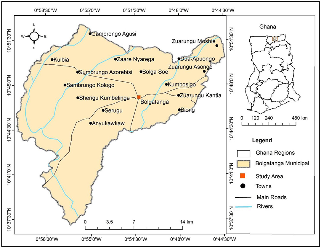
Figure 1. Map of Bolgatanga municipality of the Upper East region of Ghana.
Like in many parts of Africa, land is controlled under the customary system which is governed by well-intentioned social and cultural rules, laws, and obligations meant to grant equal access to families within groups with common interest in land (Kasanga, 1995; Yaro, 2010). In Ghana, approximately 80% of the lands are controlled by chiefs, family heads, earth priests and individuals, while the rest are held in trust by the state through compulsory acquisition (Gyapong, 2021). It is, however, crucial to point out that the Tendamba (loosely translated as Landowners) control lands in northern Ghana, while lands in the south are largely controlled by stools and chiefs (Kasanga, 1995). Land owning groups in Upper East Region includes the Tendamba, Chiefs, families, individuals, and government (ISSER, 2007). In the Bolgatanga Municipality, the Tendamba are the highest authority as far as land is concerned. The Tendaana functions as the administrator of the land and the allodial interests over the land reside in him (Kasanga and Kotey, 2001). Besides the Tendamba, other allodial rights over land are vested in various families within the Municipality. Members of these families therefore enjoy the right to use the land indefinitely.
Chiefs enjoy greater public recognition because of their social and political responsibilities to the community, however, they have limited authority over land in the Municipality (Rattray, 1929). Natives of the area are said to possess customary freehold or usufructuary rights to land (ISSER, 2007). Although this may just be the right to use the land, the period could in fact be indefinite since there are no conditions attached to the holding of such land. Non-indigenes who possess this title are also not allowed to sell any part of the land in their possession. It is believed the Tendamba were given the land by God. However, like in other parts of the country, rapid urbanization, land commoditisation and, competition between agriculture and residential uses are occasioning gradual changes in the customary land tenure arrangements and allocation dynamics. These emerging changes turn to promote haphazard developments in the peri-urban areas (Yaro, 2010) which undermine sound physical planning that delivers sustainability and resilience communities.
Urban Growth Pattern in Bolgatanga Description
Urban growth in Bolgatanga has been quite slow but predominantly along major road infrastructure networks. The city has three major roads, which define the axis of growth and development. These roads connect to divide the city into three main quarters—the old residential area, government residential area and central built-up area. These roads have significantly contributed to the morphological structure of the city (see Briggs and Mwamfupe, 2000). The old residential quarters exhibit higher densities and compactness in comparison to the government residential areas. The government residential areas typically have low densities and less compactness because of the low level of developments. The central built-up area exhibits a very compact development of single-story multi-tenanted compound houses. The reason is that these areas house the first settlers and indigenous people who have culturally lived together to protect themselves against slavery which was a common practice during the period of the slave trade. The buildings in this area are predominantly constructed along or adjacent to the city's main roads and they serve mixed-use residential and commercial functions while those farther from the roads are dominated by residential developments. In the immediate periphery of the city, however, stretching over a large expanse of the Municipality, are dispersedly distributed local family compound houses. In these inner-city areas, urban agriculture exists in the form of fenced-backyard gardens. Figure 2 is used to display the different compactness of residential developments from the Central Business District (CBD).
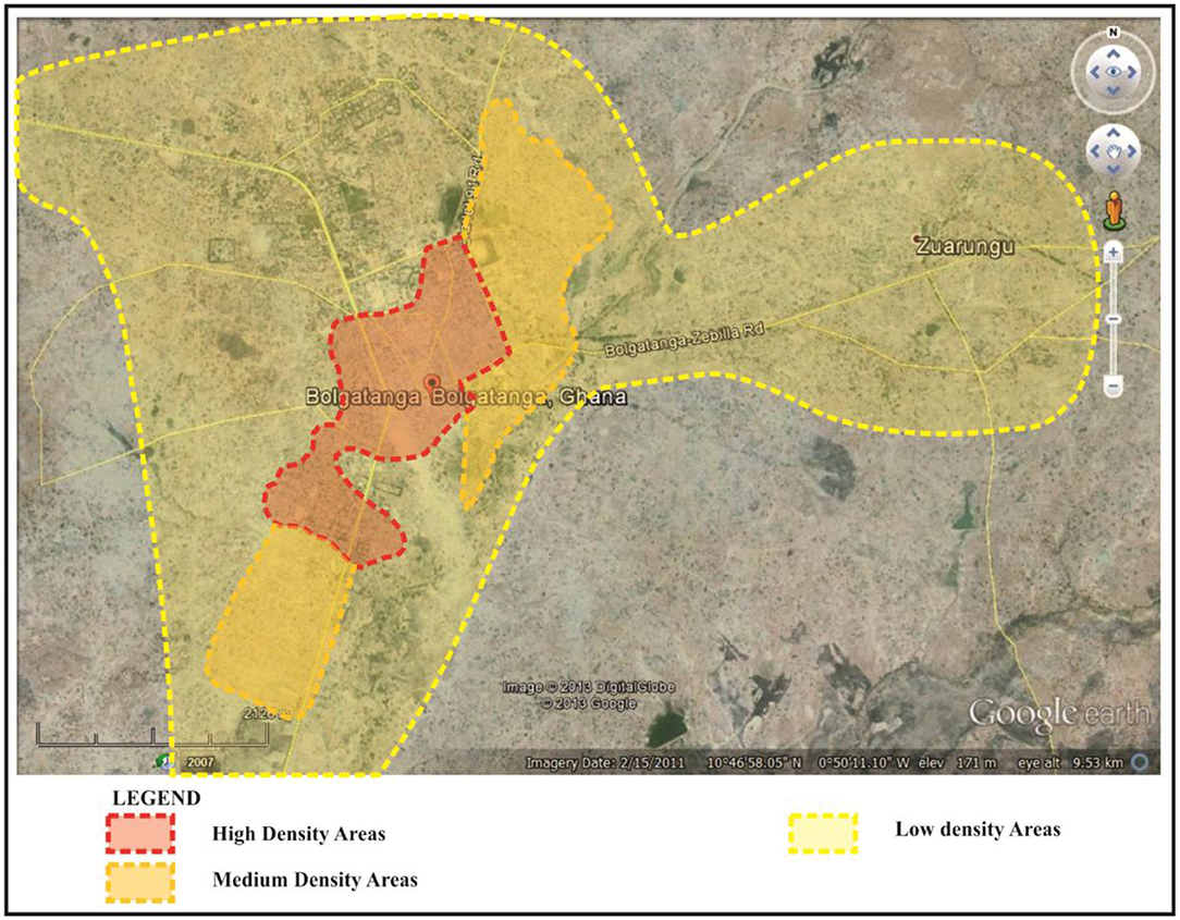
Figure 2. General distribution of densities within Bolgatanga. Source: Google Earth image with illustrations.
From the city center, running southward is the Bolgatanga-Tamale highway and eastward is the Bolgatanga-Bawku highway. These highways serve as growth poles which attract physical development activities of housing, social infrastructure, and commercial facilities. Growth of the city to the south and to the east of the city benefits from these highways as they are major entry points into the city. The Kumbosugu and Zuarungu communities have witnessed conspicuous infiltration of recent residential developments in a hitherto dispersed rural residential setting. Running from the city center northwest is the Bolgatanga-Navrongo-Paga highway, which connect beyond the national border to Ouagadougou (the capital city of Burkina-Faso). About 12 km along this road is the Sumbrungu community where the Bolgatanga Technical University is located. Even though the Bolgatanga Technical University is far from the city center, recent infrastructure developments in and around Sumbrungu has populated the area and has attracted several educational and recreational facilities in the area including the Akayet Hotel, the Millar Open University, and the Desert Pastures International School.
Bolgatanga has experienced new urban developments over the years, however, much of this development has been characterized by in-fill developments into the existing rural settlements. The growth trajectories of the city are markedly different from expansion patterns witnessed in other major towns in the northern Ghana like Tamale, Bawku, Wa and Yendi, where developments spread from the autochthonous inner cities toward the immediate hinterlands. It also appears that the city has not experienced as much influence from the pressure of non-natives coming into the area as compared to the other cities in northern Ghana. Unlike some other regional capitals located in the north of Ghana such as Tamale and Wa (see Kuusaana and Eledi, 2014, 2015a,b), where traditional settlements in the area appear to be compact and more distinct, typical villages in Bolgatanga have no distinct communal boundaries. They basically consist of scattered compounds widely interspersed over the vast landscape of the city. These growth patterns are depicted in Figure 3. Food production systems within the Bolgatanga growth pattern as elucidated above as well as the cropping seasons of the area are considered in the discussion section.
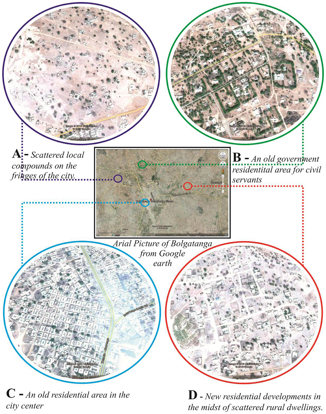
Figure 3. Aerial view of Bolgatanga showing different levels of compactness of the city. (A) Scattered local compounds o the fringes of the city. (B) An old government residential area for civil servants. (C) An old residential area in the city center. (D) New residential development as in the midst of scattered rural dwellings. Source: Authors.
Methodology—Materials and Methods
Qualitative Study Approach—Case Study, Interviews, and Descriptive Narratives
The study was conducted using the Bolgatanga Municipality (Upper East Region, Ghana) as a case study. Both explorative and descriptive narrative research approaches were used to address the research objectives. Qualitative data were collected through key stakeholder interviews at the Municipal level in two different periods. Initial fieldwork was undertaken from June 2013 to August 2013 and followed up with a second study from April 2017 to September 2017. Separate interviews were conducted with the Upper East regional and Bolgatanga Municipal planners, and the officers of the building inspectorate. The regional and municipal directors of the Ministry of Food and Agriculture (MoFA) were also interviewed. In addition, officials of the Public and Vested Land Management Division (PVMLD) and the Survey and Mapping Divisions (SMD) of the Lands Commission were interviewed. To understand how peri-urban peasant households continue to sustain agricultural land uses in residential areas, 40 household heads were surveyed. Some development plans (local plans) of the Bolgatanga Township were also studied as part of efforts to understand the spatial expansion dynamics using GIS mapping of the area. To vividly communicate some of the research findings, infographics were used. The summary of respondents for this study is put in Table 1.
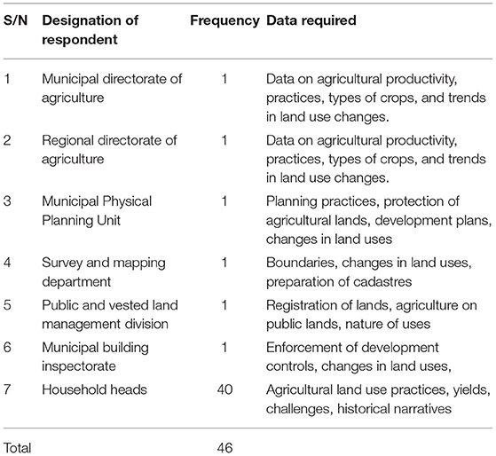
Table 1. List of respondents for the study.
Spatial Analyses Approach—Geographic Information Systems (GIS)
To understand the spatial dynamics and how agriculture has filtered through the spatial development trajectories, it was essential to carry out spatial temporal analysis. To obtain data for the GIS analyses, field data of the study areas were collected during various field visits to the study area. During these visits, a Garmin handheld GPS of accuracy between 0.3 and 3 m was used to record the GPS coordinates of the different Land Cover Land Use (LCLU) of the area. The dominant LCLU identified for the area are cultivated savannah, built area, closed trees, water, and bare land. Table 2 shows the description of the different LCLU identified in the area. With this familiarity of the study area, Google Earth was further used to generate more LCLU of the area. The timeline tool in Google Earth helped to display previous images taken between 1986 and 2017. In all, 110 points were obtained.

Table 2. Land cover classification.
Landsat satellite images covering the study area were downloaded from the USGS website Global Visualization Viewer (http://glovis.usgs.gov/). All the images selected were acquired during the dry season with no clouds or less than 10% of clouds cover. Dry season images were used because they had no or less cloud cover compared to wet season images. However, it must be mentioned that the use of dry season images may lead to a misclassification between bare lands and farmlands as their spectral reflectance may look similar. Farmland delineation was undertaken by relying on visible characteristics of farming as defined by farm boundaries, crop residues and plowing/weeding activities. The characteristics of the images selected are shown in the Table 2. The Landsat 8 image was pre-processed by converting the raw DN values into radiance and from radiance to top-of-atmosphere reflectance using the relations:
The bands were then stacked, mosaicked, and clipped to the boundary of the Nasia watershed to obtain a complete coverage of the study area. The Landsat 7 ETM image was pre-processed using the Landsat 7 reflectance tool in Erdas Imagine. This converted the DN values of the image into reflectance. Using the haze reduction tool in Erdas Imagine we did atmospheric correction of the TM images. The images were then clipped to the boundary of the study area. The images were then clipped to the boundary of urban Bolgatanga, the study area. The boundary of urban Bolgatanga was obtained from the Bolgatanga Municipal Physical Planning Unit. The image classification was done using supervised image classification approach. To perform the supervised classification, the selected ground points were superimposed on the specific image. An Area of Interest (AOI) of 3 × 3-image pixel was then extracted to represent the LCLU at that point. For each LCLU, a minimum of 10 3 × 3-image samples was selected. A signature file was then created in ESRI ArcGIS. The MLC was then used with a parallelepiped decision rule to classify the images. Urban was determined by the human settlement with the high population (estimated population of 156,678 in 2018) and corresponding infrastructure (increase in the built-up area). Though with a low density as compared to other region capitals of Ghana, the population density of the Bolgatanga Township keeps increasing over the years. The peri-urban area was estimated at 15 km radius from the city center and considered communities that had a mix of both rural and urban characteristics with a direct functional interlinkage with the Bolgatanga Township. These GIS images will be used to show the growth patterns and extend of urban Bolgatanga. The characteristics of the images selected are indicated in Table 3.
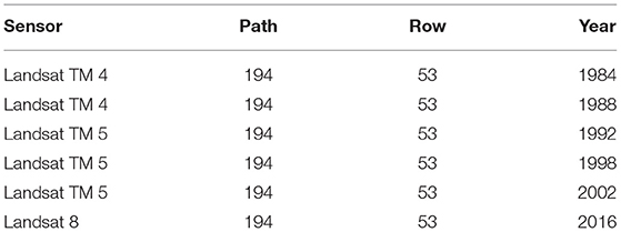
Table 3. The characteristics of the images selected.
Results and Discussions
This section has been structured into 5 subsections in line with the study's focus to understand the sustainability dynamics of urban agriculture in the wake of rapid urban expansions and population growth trajectories in the Bolgatanga Township. Section Situating the Local Level Land Tenure at the Intersection of Urban Development of the paper discusses the changing land tenure system from customary to private ownership under urban change within the context of Bolgatanga. Food production systems within the Bolgatanga growth pattern as elucidated in section Trends and Extent of Peri-Urbanization as well as the cropping seasons of the area are considered in section Characteristics of the food System in the Bolgatanga Township. Section Implications of Urbanization on Agricultural Households: Employment, Income, and Land Access of the paper focuses on the trends and extent of peri-urbanization in the Bolgatanga from the year 2000 to 2018, while Section Phases of Agricultural Land Use Change in Bolgatanga Township looks at the phases of agricultural land use change in Bolgatanga.
Situating the Local Level Land Tenure at the Intersection of Urban Development
The customary land tenure system in the Bolgatanga Township invariably impacts on the urban development dynamics of the city. For instance, the parceling of land for urban uses, particularly those lands which emanate from the patriarchal inheritance practices, provides the entry point for urban development of the area. At the community level, land is owned by families, and this is passed on across generations as contiguous parcels or splintered parcels for nuclear family or even individual uses. The splintering of land into smaller parcels leads to land fragmentation, as the small parcels ends up unsuitable for agriculture and local planning (parcel by parcel planning) (Tonah, 2005). In previous research findings, Agana (2012) revealed that, customarily, land could be accessed, acquired, and owned among the Frafra communities by first settlement and by gift or grant from the landowning family. Land could also, however, be battered for cattle or pledged for cattle used for marriage dowry on promise by the pledgor to replace the cattle and redeem the land in future. However, due to urbanization and high population growth there is an existing commercialized exchange system, characterized by both informal and formalized land transaction, and this has promoted sale of land. Sale of family lands are meant to enable impoverished landowning families or individuals to raise money for critical social needs including funerals, sickness, travel expenses, educational supports, traditional marriage requirements, festivals and to support other essential livelihoods. In addition, chiefs and families are gradually interpreting common land as private ownership, which facilitates the selling of land for housing.
In addition, the public investment in improving road infrastructure for example, has significantly influenced peri-urban land marketisation. For instance, a household head explained,
“improvement in accessibility through road construction has caused land values to appreciate making land a ‘black gold’ in the peri-urban communities” (Interview, male household head, Bolgatanga, 2017).
The Municipal Physical Planner also indicated that,
“the main factors causing land use change in peri-urban areas are high demand for land by the increasing population from the city center, and to dispose lands for monetary gains by landowners” (Interview with Municipal Physical Planner, Bolgatanga, 2017).
The Municipal agriculture officer also noted that,
“there has been a decrease in the average farm sizes between 2000 and 2010 from 3 to 0.36 ha under small-scale farming and 11 to 8 ha under large scale farming with residential land developments fast consuming agricultural lands, respectively” (Interview with Municipal Agriculture Officer, Bolgatanga, 2017).
These concerns represent the motivations, drivers and complications that may emanate from the operationalisation of urban plans and policies within cities in Ghana due to the dominance of customary tenure and multiple interests at both the community and family levels. Agricultural lands are mostly affected by rapid urban growth and its functional demands, such as land uses for residential, industrial, and commercial tend to dominate agricultural lands in the bid for space in the urban setup (Owusu and Lawrence, 2010). Naab et al. (2013) argue that a major problem of rapid urban growth is changing land-use patterns which affects agricultural land use, land sizes and crop yield. According to Appiah et al. (2014) the decision to convert land from agricultural uses to residential and commercial land uses are driven by both social and economic factors (see Kasanga et al., 1996; Kidido and Bugri, 2020; Kidido, 2021). Kuusaana and Eledi (2015a) opined that, efforts of governments to make cities self-sustaining in terms of producing their food locally will remain a mirage if there is no productive land available. Lyons et al. (2013) have also noted that, contemporary planning approaches are constrained by several factors including social, political, ecological, and economic boundaries that reduce options for growing food within the urban space. These factors appear to resonate in other jurisdictions as seen in our results in the Bolgatanga with the dissipation of urban agricultural land (see Akaateba, 2019; Akaateba et al., 2021).
Trends and Extent of Peri-Urbanization
This section of the paper focuses on the trends and extent of peri-urbanization in the Bolgatanga Township from the year 2000 to 2018. The population for Bolgatanga leapfrogged from 77,768 people in the year 2000 to 156,678 in 2018. This growth represents twice increase compared to the population figure recorded in 2000. The annual population growth rate was 5.64%. The implication of rapid population increase has a direct link to rapid expansion of residential land uses in these peri-urban settlements. The growing population of the Bolgatanga Township has spilt over surrounding areas, which constitute what can be called the peri-urban Bolgatanga. These areas, which include Tindomoligo, Yikene, Yarigabisi, and Tindonsobligo among others, offer cheaper land for housing development for the increasing urban population and for other complementary urban activity as well. The rapid urban growth is attributed to natural population growth and migration from rural areas due to poverty and land conflicts (Ampofo et al., 2015). The Bolgatanga Muncipality has experienced a rapid urban land expansion over the past 30 years; it increased by 6 times; from 499.49 hectares in 1984 to 1525.14 hectares in 2016 with an annual growth rate of 6.4%.
The field survey revealed that the pace of urban expansion in the Bolgatanga Muncipality between 1984 and 2002 was 2.8% per annum as against 8.6% per annum for the year 2002 to the year 2016. While the built up area in 1984 spanned to only 2 km from the city center, by 2016 the growth of the city had reached about 12 km. Clearly, the last two decades witnessed a drastic expansion of the Municipality. This is attributable to key developmental activities such as the redevelopment of the township and the upgrading of the city core after 2002. The expansion trajectory of the Bolgatanga Township is further explained by the establishment some critical social and commercial facilities which has served as growth poles and pull forces of development in the last two decades. For instance, there is a general concensus among the studied urban households that the establishment of Millar Institute for Transdisciplinary and Development Studies (now known as the Millar Open University, Bolgatanga Technical University, Bolgatanga and Zuarungu Nursing Training Colleges, Zuarungu Meat Factory, Bolgatanga Rice Mill and many of such establishments have triggered the expansion of the social, economic, and educational sector with intense effect on the spatial transformations of the town.
The analysis of the 1984–2016 data indicated that there is an inverse relationship between built up area and farmland. Whiles the share of urban farmlands was decreased from 1299.60 hectares to 115.07 hectares, built up area was on an increase from 455.07 hectares to 1,525 hectares. From Figure 4, the period between 2002 and 2016 recorded the highest spatial expansion with built up (proportion of urban share) of the study area increased from 682.92 (30%) to 1525.14 hectares (70%), almost triple, while the extent of farmland decreased drastically from 652.05 hectares (85%) to 115.07 hectares (15%). The spatial analysis implies that about 567.85 hectares of peri-urban land initially previously used for agriculture and related activities were built-up between 2002 and 2016. The spatial expansion between 2002 and 2016 was attributed to the infrastructural development that occurred within that same period. Also housing development was more of infilling, completion of abandoned and uncompleted projects as well as redevelopment of old structures (especially at the inner cities) among others largely influenced the growth and expansion of Bolgatanga. This result corroborates the view that most cities in developing countries are characterized by unconsolidated lateral physical expansion and sprawl (Webster and Muller, 2002; Kombe, 2005; Cobbinah and Amoako, 2012). This is plausibly because of the increased urban share of the population in Bolgatanga from 32,495 in 1984 to 65,549 in 2010 (Ghana Statistical Service, 2014b). The Municipality recorded the largest growth in urban population in the region as of 2014. The expansion of the urban frontprint also increases rural spatial demand to accommodate the growing population and economic activities.
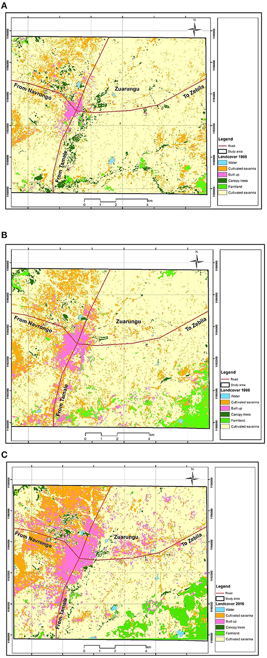
Figure 4. (A–C) GIS maps showing urban development dynamics and loss of vegetation in Bolgatanga township.
Further spatial analysis (as shown in Table 4) indicates that bare land which comprised of all vacant spaces, sands, rocky areas, cleared lands occupied 3,550.32 hectares in 1984. However, this subsequently decreased to 2,978.54 hectares in 2016 due to the supply of land for housing construction. Water bodies also increased from 32 hectares in 1984 to 52 hectares in 2016 comprising rivers and dams in the area. The increase is as a result of construction of new dams and expansion of existing dams such as the Vea dam and Gambibgo-Azuabisi dam expansion projects by the Government of Ghana. The rural water supply system consists of boreholes, hand-dug wells and other natural water sources such as rivers, dams, ponds and dugouts. The water supply system in the Municipality can be classified into rural and urban, based on the location of the facilities and the technology of delivery. The results also show that the farmland and canopy trees decreased over the years from 1,299.60 hectares to 115.07 hectares, 791.1 hectares to 259.65 hectares, respectively between 1984 and 2016 as a result of the increased conversion of farmland to housing and also due to the felling of trees for charcoal burning and farming.
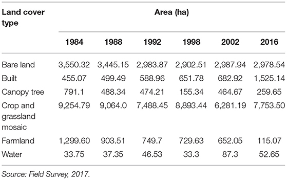
Table 4. Changes in the land size for the different uses in the study areas.
With urbanization expansions occasioned by population growth, naturally, agricultural land was severely impacted as depicted in Table 4. The reduction in farmland sizes also presents some unintended consequences and implications on households within these frontiers. According to Steinhübel and von Cramon-Taubadel (2021) the diminishing prospect of urban agriculture reallocates labor to non-agrarian urban economies. These implications are largely manifested in the form of food supply challenges, land access, income, and livelihoods of people. These are discussed in the next section.
Characteristics of the Food System in the Bolgatanga Township
Across the households studied, the major food crops, maize, rice, millet, sorghum, groundnuts, cassava, and cowpea make up the main staple foods of the people in Bolgatanga. Farmers in the rural and peri-urban areas mainly produce food for subsistence and income. After harvesting, farmers put aside some of the foodstuff for the family subsistence while the rest is sold in the market. Farmers may sell farm produce in bulk or bits as and when the need arises to meet pressing expenses at the family or individual level. Rural farm produce is, however, distributed differently through organized transport systems or through private means to market centers. Urban consumers purchase their food from the local markets. In the urban centers, different neighborhoods have different localized market centers, where they access food supply on daily or weekly bases. Such a market center exits in the Bolgatanga Township and runs every 3 days.
The cropping period is vastly dependent on the rainfall pattern and the crop under cultivation (see in Figure 5). Hence, the cropping calendar may vary slightly from year to year depending on when the rains commence. Land preparations usually commence after the first rains which is mostly around April. As such, when the rains delay, it tends to cause a delay in the preparation of the fields for planting and consequently, delays the entire cropping season. Farming in terms of crop production in the area like the rest of Ghana, is primarily seasonal rainfed. The earlier part of the dry season is used for processing and storage of the farm produce. Some farmers also engage in irrigation-based vegetable production in the dry season around their homes and in designated irrigated valleys across the city. In the Upper East Region irrigated tomatoes farming thrives during the dry season. In the rural areas, farmers farm around their compound where there is hardly a distinction between the compound and farms because farmlands extend from the very edge of the compound. However, urban, and peri-urban farmlands are dynamic with varying phases of the landscape as the seasons and the development priorities change. The settlements themselves, however, remain largely static. Some of these characteristics are displayed in Figures 6, 7.

Figure 5. Cropping calendar for major food crops in the wet season in the study area. Source: Author's illustration with information from Agricultural Extension Handbook (2006).

Figure 6. A typical compound farm in Yikene in Bolgatanga Source: Field Survey, 2013.
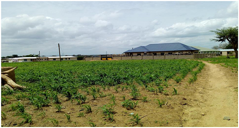
Figure 7. Land use change in peri-urban Yikene in Bolgatanga Source: Field Survey, 2017.
Implications of Urbanization on Agricultural Households: Employment, Income, and Land Access
Peri-urbanization is said to be double-edged sword because urban expansion is documented to present both limitations and opportunities to people living in the urban periphery (Aberra and King, 2005). In terms of opportunities urban areas provide many potentials for improving living conditions through economies of scale and proximity they provide for most forms of infrastructure and services (Satterthwaite et al., 2010). Improvement in urban-based employment and social amenities such as access to healthcare, improvement in access to quality education, and regular supply of potable water are also critical opportunities available to peri-urban households (see Mandere et al., 2010; Vermeiren et al., 2013). It was revealed through this study that the outward expansion of Bolgatanga has created multiple livelihood opportunities in the communities such as, construction work, welding, NGO's, electricians, craftsmanship and trading business because of their proximity to the city. Even though these new livelihood opportunities are peculiar to the urban populace, it creates agricultural labor shortages in the peri-urban fringes (see Hussain and Hanisch, 2014). The study further found that the proportion of men in these jobs were significantly higher than the females, especially in the construction industry (see Brook and Dávila, 2000; Tacoli and Satterthwaite, 2013).
It is argued that the process of peri-urbanization is characterized by changing local economic and employment structures, from agriculture to manufacturing (Bah et al., 2003; Narain and Nischal, 2007; Hudala et al., 2008; Mandere et al., 2010). Nevertheless, observation from the Bolgatanga Township reveals that the process of peri-urbanism is not characterized by growing industrialization. An elder in Yarigabisi commenting on the effects of peri-urbanization on their income noted as follows:
“My son I hardly find money these days due to loss of farmlands, and I lack employable skills and requisite qualifications for available jobs in my community. Since I lost my farmland, my financial situation has worsened than before. My income has decreased significantly, I cannot afford three square meals in a day less to talk of accessing health care. When we fall sick, we pray to God to heal us” (Interview, Elder, Yarigabis-Bolgatanga, 2017).
The cost of land acquisition is one of the main factors that determine the accessibility to land for agricultural purpose (Pavel et al., 2012). Peri-urbanization is accompanied by certain changes in agricultural practices as farm sizes reduce in the peri-urban areas. Farmers have adopted all forms of strategies to survive. During the field survey, respondents indicated that agricultural practices have undergone changes over the last decade in response to peri-urbanization. For instance, labor shortages have compelled urban farmers to choose less labor-intensive farming methods (see Nguyen and Kim, 2019) or concentrate on only high yielding or high value crops (see Hussain and Hanisch, 2014). Most farmers have shifted from the traditional extensive agriculture toward intensive agricultural practices where crops with shorter gestation period as well as high valued crops either as a survival strategy or accumulation strategy (Tacoli, 2004; Mandere et al., 2010; Thuo, 2010).
Peri-urbanization usually leads to declining landholdings at the household level, which possibly diminishes the economic significance of agriculture in the cities (Kuusaana and Eledi, 2015a; Haller, 2017; Pribadi et al., 2017). The negative effects of peri-urbanization are manifested in the greater loss of agricultural land and the growing integration into the urban monetised economy. Urban intrusion displaces traditional livelihoods in the urban and peri-urban areas (see Babo, 2010). This point is buttressed by Dávila (2002) that majority of the peri-urban poor who depend heavily on natural resources are worse affected by urban expansion. There is a gradual shift from full time farming to part farming or abandonment of farming (Lerner and Appendini, 2011; Mosha, 2015). Abandonment of farming is, however, widespread because of its informality, low level technological adaptation and its association with economically poor households (see Feola et al., 2020). How the overall urban expansion morphology mutates existing agrarian landholdings and agricultural structure of the local inhabitants is further elaborated in section 5.5.
Phases of Agricultural Land Use Change in Bolgatanga Township
Growing population and urban expansion goes with no concomitant growth in land supply because land is fixed in supply and does not in any way grow with increasing population growth (Ampofo et al., 2015). The pressure exerted by increasing population and rapid urban sprawl dispossess other sectors such as agriculture (Edusah, 2008). The analysis of the different levels of compactness in the urban built up area, in relation to the practice of urban agriculture (see Figure 8) reveals different phases of food production capacities in the Bolgatanga Municipal area. In the peri-urban interface, urban growth is driven by individual developments. Thus, the level of compactness in these areas increases gradually over several years, with most people developing their houses in piecemeal fashion (Adade et al., 2021). Farmers in these areas therefore lose their farms gradually, with infilling as individuals develop their separate parcels of land. The loss of production capacity therefore takes place gradually. Figure 8 illustrates these dynamics in the form of an infograph.
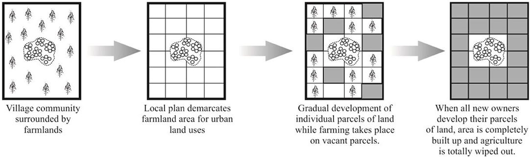
Figure 8. Changing phases of rural agricultural landscape into urban built-up land. Source: Authors Illustration, 2021.
The process of peri-urbanization poses serious threats to urban and peri-urban farmers because of the scarcity of agricultural land. The peri-urban interface in most cases is the agricultural hub of the urbanites and supplies its food requirements (Atu et al., 2013). At the plight of losing their farmlands to urbanization and urban growth, peri-urban and urban farmers have had to find adaptive measures to survive. Urban area growth does not wipe out the indigenous rural settlements that become urbanized. Hence, under the same circumstances, farmers lose their farms and not their homes through a slow land use conversion process. The scenario described supra is illustrated in Figure 9. Although farm sizes in the peri-urban interface are typically small as compared to rural farms in the hinterlands, they are generally bigger than the sizes of an average plots of land as defined in many local plans in Ghana. The situation therefore arises where a parcel of land which was previously cultivated by one farmer is subdivided into plots and allocated to several different residential developers. The decisions of these developers to develop their parcels piecemeal means that the farm sizes gradually decreases until the farmer is compelled to relocate to the periphery or abandon farming. In the end, however, relocation of the farmlands is a sure option for many urban farmers due to diminishing farm sizes and poor accessibility to water resource (see Foeken and Owuor, 2008; Taiwo, 2014). Hence, the sustainability of urban agriculture is constructed on the farmers' abilities to identify alternative farmlands either in the immediate residential neighborhoods or in distant peripheries.
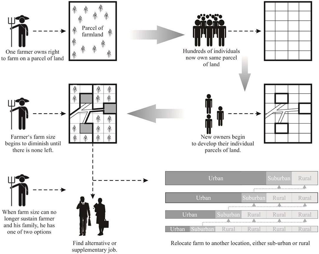
Figure 9. Gradual disappearance of rural farmlands in the peri-urban interface. Source: Authors Illustrations, 2021.
Conclusion and Recommendation
Urban food supply remains critical for the functioning of the urban populace. Understanding the characterization of urban areas and how they sustain urban food production is relevant. The conversion of urban agricultural land to residential uses has multiple impacts on the urban food system and the sustainability of urban agriculture. These land use changes have led to rapid transformations and [re]structuring of agricultural production, spatial dynamics, social-economic [f]actors, land ownership and land markets. Encroachment on urban and peri-urban agricultural lands leads to changes in the customary processes and procedures of land tenure as land becomes commoditized rather than a communal property. The changes manifest in the emergence of formal and informal land transaction activities that have emerged as the local economy shifts from a batter economy to a monetised one through socio-economic induced land transactions. This is because of the disconnection and low-level participation of the planning authorities on one hand, and the customary landowners on the hand. The development of Bolgatanga is anchored on the morphology of the major road network in the city center. However, there is variation in level of compactness: higher housing density in the older inner-city settlements, and lower density in the government residential and peri-urban areas due to regulations and piecemeal development of residential housing. Notwithstanding rapid urbanization, local peasant farmers are still able to secure small patches of farmlands within the city to engage informally in agriculture with insecure tenure. Of critical notice is the fact that the rapid urban expansion into the peri-urban communities has created multiple livelihood opportunities in the communities even though these are skewedly male dominated.
In Bolgatanga, food production capacities are being shifted from one locality to another in the face of increasing urban growth. There is a deepening agro-ecological impact of urban expansion on urban food production and the supply of ecosystem goods and services within the urban core and peripheries. This is set to exacerbate in the coming decades due to increasing urban population. Since securing safe and sufficient food for the urban population is critical to sustainable development, this study recommends that, food-inclusive planning schemes are fundamental in future physical plans to guide land uses. These planning schemes can be developed and sustained through multiple sectoral/stakeholder planning processes. Key stakeholders including the traditional authorities, farmers, planning authorities and youth groups should see these food-inclusive planning schemes as a shared responsibility in ensuring strict adherence and implementation. This process can then be supported by the respective planning authorities through regulation and monitoring.
Data Availability Statement
The datasets presented in this article are not readily available because data was used previously as MSc./M.Phil. thesis which the authors were involved. Requests to access the datasets should be directed to Elias D. Kuusaana, ZWt1dXNhYW5hQHlhaG9vLmNvbQ==.
Author Contributions
EK worked the lead author and contributed to the conception and writing of the manuscript. IA helped in data collection and used same for his M.Phil. Thesis in 2017. JE also collected data in Bolgatanga in 2013 and used it for her MSc. Thesis. IA and JK both contributed to the review of critical literature and defining the focus of this manuscript. All authors contributed to the article and approved the submitted version.
Funding
This research was fully funded and operationalized by the authors using their personal resources.
Conflict of Interest
The authors declare that the research was conducted in the absence of any commercial or financial relationships that could be construed as a potential conflict of interest.
Publisher's Note
All claims expressed in this article are solely those of the authors and do not necessarily represent those of their affiliated organizations, or those of the publisher, the editors and the reviewers. Any product that may be evaluated in this article, or claim that may be made by its manufacturer, is not guaranteed or endorsed by the publisher.
References
Abass, K., Adanu, S. K., and Agyemang, S. (2018). Peri-urbanisation and loss of arable land in Kumasi Metropolis in three decades: evidence from remote sensing image analysis. Land Policy 72, 470–479. doi: 10.1016/j.landusepol.2018.01.013
Abdulai, I. A., Derbile, E. K., and Fuseini, M. N. (2021). Livelihood diversification among indigenous peri-urban women in the Wa Municipality, Ghana. Ghana J. Dev. Stud. 18, 72–96. doi: 10.4314/gjds.v18i1.4
Abdulai, I. A., Enu-kwesi, F., and Agyenim, J. B. (2020). Peri-urbanisation: a blessing or scourge? J. Plann. Land Manag. 1, 12–22. doi: 10.36005/jplm.v1i2.23
Aberra, E., and King, R. (2005). Additional knowledge of livelihoods in the Kumasi peri- urban interface (KPUI), Ashanti Region, Ghana, Development Planning Unit, and University College London. Accra: Yamens Press Limited.
Adade, D., Kuusaana, E. D., de Vries, W. T., and Gavu, E. K. (2021). Housing finance strategies for low-Income households in secondary cities: contextualization under customary tenure in Ghana. Housing Policy Debate. doi: 10.1080/10511482.2021.1905026
Adriana, A. (2003). Environmental planning and management of the peri-urban interface: Perspective on an emerging field. Environ. Urban. 15, 135–147. doi: 10.1177/095624780301500103
Adu-Ampong, E., Cudjoe, F., Edusah, A. R., Hoogsteen, M., Oteng, L., Vlek, F., et al. (2008). Socio-economic transitions, changing livelihoods in the peri-urban interface: A case study of Ahenemah Kokoben and Tikrom in the peri-urban interface of Kumasi, TSPA-Project Report:7–12.
Agana, C. (2012). Women's Land rights and access to credit in a predonminatly patrilineal system of inheritance: Case study of the Frafra Traditional Area, Upper East Region. Retrieved from: http://ir.knust.edu.gh/bitstream/123456789/5036/1/Charles%20Agana.pdf
Aguilar, A., and Ward, P. (2003). Globalization, regional development and mega-city expansion in Latin America: analysing Mexico City's peri-urban hinterland. Cities 2:3–21. doi: 10.1016/S0264-2751(02)00092-6
Akaateba, M. A. (2019). The politics of customary land rights transformation in peri-urban Ghana: Powers of exclusion in the era of land commodification. Land Use Policy 88, 104197. doi: 10.1016/j.landusepol.2019.104197
Akaateba, M. A., Ahmed, A., and Inkoom, D. K. B. (2021). Chiefs, land professionals and hybrid planning in Tamale and Techiman, Ghana: Implications for sustainable urban development. Int. J. Urban Sustain. Dev. 1–18. doi: 10.1080/19463138.2021.1971990
Allen, A. (2003). Environmental planning and management of the peri-urban interface: Perspectives on an emerging filed. Environ. Urbanizati. 15, 135–148. Available online at: http://newruralism.pbworks.com/f/allen.pdf
Ampofo, S., Kumi, E., and Ampadu, B. (2015). Investigating solid waste management in the Bolgatanga Municipality of the Upper East Region, Ghana. Environ. Pollut. 4, 27–41. doi: 10.5539/ep.v4n3p27
Anarfi, K., Hill, R. A., and Shiel, C. (2020). Highlighting the sustainability implications of urbanisation: a comparative analysis of two urban areas in Ghana. Land 9, 300–324. doi: 10.3390/land9090300
Angel, S., Sheppard, S. C., and Civco, D. L. (2005). The Dynamics of Global Urban Expansion. Washington, DC: World Bank, Transport, Urban Development Department.
Annez, P., Buckley, R., and Kalarickal, J. (2010). African urbanization as flight? Some policy implications of geography. Urban Forum 21, 221–234. doi: 10.1007/s12132-010-9085-6
Appiah, D., Bugri, J., Forkuor, E., and Boateng, P. (2014). Determinants of peri-urbanization and land use change pattern in peri-urban Ghana. J. Sustain. Deve. 7, 95–108. doi: 10.5539/jsd.v7n6p95
Atu, J. E., Offiong, R. A., and Eja, I. (2013). Urban sprawl effects on biodiversity in peripheral agricultural lands in Calabar, Nigeria. J. Environ. Earth Sci. 3, 219–231. Available online at: https://www.iiste.org/Journals/index.php/JEES/article/view/6408
Babo, A. (2010). Sociopolitical crisis and the reconstruction of sustainable peri-urban agriculture in Abidjan, Cote d'Ivoire. Afr. Stud. Rev. 53, 101–120. doi: 10.1017/S0002020600005692
Bah, M., Cissé, S., Diyamett, B., Daillo, G., Lerise, F., Okali, D., et al. (2003). Changing rural-urban linkages in Mali, Nigeria and Tanzania. Environ. Urban 15, 13–24. doi: 10.1177/095624780301500104
Bates, A, Gibson, J, Hemming, C, Howarth, R, Orridge, S, Shaw, S, and Gardner, D. (2014). Garden and landscape-scale correlates of moths of differing conservation status: Significant effects of urbanisation and habitat diversity, PLoS One. 9, 1–11. doi: 10.1371/journal.pone.0086925
Bonye, S. Z., Yiridomoh, G. Y., and Bebelleh, F. D. (2020). Compliance with land use regulations in peri-urban areas in Ghana: a study of Bamahu and Danko residential areas in Wa municipality, Upper West Region. GeoJournal 86, 2845–59. doi: 10.1007/s10708-020-10229-w
Bonye, S. Z., Yiridomoh, G. Y., and Derbile, E. K. (2021). Urban expansion and agricultural land use change in Ghana: implications for peri-urban farmer household food security in Wa Municipality. Int. J. Urban Sustain. Dev. 13, 383–399. doi: 10.1080/19463138.2021.1915790
Bricas, N., Dury, S., Figuié, M., Maire, B., and Delpeuch, F. (2003). Sécurité Alimentaire et Urbanisation: Enjeux pour l'agriculture Intra et péri-urbaine. Comptes-rendus de l'Académie d'agriculture de France 89, Paris, France.
Briggs, J., and Mwamfupe, D. (2000). Peri-urban Development in an Era of Structural Adjustment in Africa: The City of Dar es Salaam, Tanzania. Urban Stud. 37, 797–809. doi: 10.1080/00420980050004026
Brook, R. M., and Dávila, J. D., (eds.). (2000). The Peri-Urban Interface: A Tale of Two Cities. London: School of Agricultural and Forest Sciences, University of Wales and Development Planning Unit, University College London, 170–195.
Centre for Development of People (CEDEP) (2005). Who Can Help the Peri-Urban Poor (R8090). Final Technical Report, Kumasi.
Chirisa, I. (2010). Peri-urban dynamics and regional planning in Africa: Implications for building healthy cities. J. Agric. Extens. Rural Dev. 2, 16–25. doi: 10.5897/JASD.9000027
Cobbinah, P. B., and Amoako, C. (2012). Urban sprawl and the loss of peri-urban land in Kumasi - Ghana. Int. J. Soc. Hum. Sci. 6:388e. doi: 10.5281/zenodo.1090862
Cobbinah, P. B., Gaisie, E., and Owusu-Amponsah, L. (2015). Peri-urban morphology and indigenous livelihoods in Ghana. Habitat Int. 50, 120–129. doi: 10.1016/j.habitatint.2015.08.002
Cortinovis, C., and Geneletti, D. (2018). Ecosystem services in urban plans: What is there, and what is still needed for better decisions. Land Use Policy 70, 298–312. doi: 10.1016/j.landusepol.2017.10.017
Coulibaly, B., and Li, S. (2020). Impact of agricultural land loss on rural livelihoods in peri-urban areas: Empirical evidence from Sebougou. Mali. Land 9, 470–490. doi: 10.3390/land9120470
Czekajlo, A., Coops, N. C., Wulder, M. A., Hermosilla, T., White, J. C., and van den Bosch, M. (2021). Mapping dynamic peri-urban land use transitions across Canada using Landsat time series: Spatial and temporal trends and associations with socio-demographic factors. Comput. Environ. Urban Syst. 88, 101653(1–13). doi: 10.1016/j.compenvurbsys.2021.101653
Dávila, J. D. (2002). Rural-Urban Linkages: Problems and Opportuities. Espaço and Geografia. Available online at: https://www.researchgate.net/publication/237393100_RURAL-URBAN_LINKAGES (accessed October 21, 2021).
De Bon, H., Parrot, L., and Moustier, P. (2010). Sustainable urban agriculture in developing countries. A review. Agron. Sustain. Dev. 30, 21–32. doi: 10.1051/agro:2008062
Drechsel, P., and Dongus, S. (2010). Dynamics and sustainability of urban agriculture: examples from sub-Saharan Africa. Sustain. Sci. 5, 69–78. doi: 10.1007/s11625-009-0097-x
Dutta, V. (2012). Land use dynamics and peri-urban growth characteristics reflections on master plan and urban suitability from a sprawling North Indian City. Environ. Urbaniz. ASIA 3, 277–301. doi: 10.1177/0975425312473226
Edusah, S. E. (2008). “Land use, land allocation and the environment in Kumasi and its peri-urban communities of Ghana,” in 12th EADI General Conference on Global Governance for Sustainable Development: The Need for Policy Coherence and New Partnerships (Geneva).
FAO (2011). Food, Agriculture and Cities. Challenges of Food and Nutrition Security, Agriculture and Ecosystem Management in an Urbanizing World. FAO Food for the Cities multi-disciplinary Initiative Position Paper.
Feola, G., Suzunaga, J., Soler, J., and Wilson, A. (2020). Peri-urban agriculture as quiet sustainability: Challenging the urban development discourse in Sogamoso, Colombia. J. Rural Stud. 80, 1–12. doi: 10.1016/j.jrurstud.2020.04.032
Foeken, D. W. J., and Owuor, S. O. (2008). Farming as a livelihood source for the urban poor of Nakuru, Kenya. Geoforum 39, 1978–1990. doi: 10.1016/j.geoforum.2008.07.011
Follmann, A., Willkomm, M., and Dannenberg, P. (2021). As the city grows, what do farmers do? A systematic review of urban and peri-urban agriculture under rapid urban growth across the Global South. Landscape Urban Plann. 215,104186. doi: 10.1016/j.landurbplan.2021.104186
Fuseini, I., Yaro, J. A., and Yiran, G. A. (2017). City profile: Tamale, Ghana. Cities 60, 64–74. doi: 10.1016/j.cities.2016.07.010
Gantsho, S. V. M. (2008). “Cities as growth poles: implications for rural development,” in A Paper Presented at Annual Meetings Seminar (Maputo).
Ghana Statistical Service (2010), 2010 Housing and Population Census, Bolgatanga Municipality, Ghana.
Ghana Statistical Service (2012). 2021 Population and Housing Census, Press Release on Provision Results. Accra: Ghana Statistical Service.
Ghana Statistical Service (2014a). 2010 Population and Housing Census. District analytical report. Bolgatanga Municipality, Ghana. Available online at: https://www2.statsghana.gov.gh/docfiles/2010_District_Report/Upper%20East/Bolga.pdf
Ghana Statistical Service (GSS) (2014b). 2010 Population and Housing Census. District Analytical Report-Accra Metropolitan. Ghana Statistical Service, Accra.
Ghana Statistical Service (GSS) (2002). 2000 Population and Housing Census. Special Report on Urban Localities. Ghana Statistical Service, Accra.
Ghana Statistical Service, (2021). 2021 Population and Housing Census: Press Release on Provisional Results. Ghana: Ghana Statistical service Accra.
Gyapong, A. Y. (2021). Commodification of family lands and the changing dynamics of access in Ghana. Third World Q. 42, 1–19. doi: 10.1080/01436597.2021.1880889
Hackman, J. K., Ayarkwa, J., Osei-Asibey, D., Acheampong, A., and Nkrumah, P. A. (2021). Bureaucratic factors impeding the delivery of infrastructure at the Metropolitan, Municipal and District Assemblies (MMDAs) in Ghana. World J. Eng. Technol. 9, 482–502. doi: 10.4236/wjet.2021.93032
Haller, A. (2014). The “sowing of concrete”: Peri-urban smallholder perceptions of rural-urban land change in the Central Peruvian Andes. Land Use Policy 38, 239–247. doi: 10.1016/j.landusepol.2013.11.010
Haller, A. (2017). Urbanites, smallholders, and the quest for empathy: prospects for collaborative planning in the periurban Shullcas Valley, Peru. Landsc. Urban Plan. 165, 220–230. doi: 10.1016/j.landurbplan.2016.04.015
Hudala, D., Winarso, H., and Woltjer, J. (2008). Peri-urbanisation in East Asia: a new challenge for planning. Int. Dev. Plann. Rev. 29:503–519. doi: 10.3828/idpr.29.4.4
Hussain, Z., and Hanisch, M. (2014). Dynamics of peri-urban agricultural development and farmers' _adaptive behaviour in the emerging megacity of Hyderabad, India. J. Environ. Plann. Manag. 57, 495–515. doi: 10.1080/09640568.2012.751018
Irwin, E. G., and Geoghegan, J. (2001). Theory, data, methods: developing spatially explicit economic models ofland use change. Agric. Ecosyst. Environ. 85, 7–23. doi: 10.1016/S0167-8809(01)00200-6
ISSER (2007). Synthesised Regional Report for Land Administration Project, Ministry of Lands, Forestry and Mines. Legon: University of Ghana.
Kaba, A. J. (2020). Explaining Africa's rapid population growth, 1950 to 2020: trends, factors, implications, and recommendations. Sociol. Mind 10, 226–268. doi: 10.4236/sm.2020.104015
Kasanga, R. K. (1995). Land tenure and regional investment prospects: the case of the tenurial systems of Northern Ghana. J. Property Manag. 13, 21–31. doi: 10.1108/02637479510083780
Kasanga, R. K., Cochrane, J, King, R., and Roth, M. (1996). Land Markets and Legal Contradictions in the Peri-Urban Area of Accra Ghana: Informant Interviews and Secondary Data Investigations, Land Tenure Centre Research Paper 127. Madison: University of Wisconsin. and Land Administration Research Centre, UST.
Kasanga, R. K., and Kotey, N. A. (2001). Land Management in Ghana: Building on Tradition and Modernity. London: International Institute for Environment and Development (IIED).
Kidido, J. K. (2021). Creation of Ahafo region and local land market dynamics; evidence from Goaso and Nkaseim stool land areas in Ghana. Survey Rev. doi: 10.1080/00396265.2021.1970917
Kidido, J. K., and Bugri, J. T. (2020). Youth Access to Agricultural Land from Peri-urban and Rural Perspective: a Study of Techiman Traditional Area in Ghana. J. Land Rural Stud. 8, 37–56. doi: 10.1177/2321024919883145
Kleemann, J., Inkoom, J., Thiel, M., Shankar, S., Lautenbach, S., and Fürst, C. (2017). Peri-urban land use pattern and its relation to land use planning in Ghana, West Africa. Landsc. Urban Plan. 165, 280–294. doi: 10.1016/j.landurbplan.2017.02.004
Kombe, W. J. (2005). Land use dynamics in peri-urban areas and their implications on the urban growth and form: case of dar es salaam, Tanzania. Habitat Int. 29, 113–135. doi: 10.1016/S0197-3975(03)00076-6
Kuusaana, E. D. (2016). Large-scale land acquisitions for agricultural investments in Ghana - implications for land markets and smallholder farmers. Dissertation, Rheinische Friedrich-Wilhelms-Universität Bonn, Bonn. Available online at: https://nbn-resolving.org/urn:nbn:de:hbz:5n-45092 (accessed September 15, 2021).
Kuusaana, E. D., and Eledi, J. A. (2014). Uncontrolled Urbanisation in Ghana: a concern for food systems in the wa municipality. J. Sustain. Dev. Stud. 6, 260–293. Available online at: https://infinitypress.info/index.php/jsds/article/view/708
Kuusaana, E. D., and Eledi, J. A. (2015a). As the city grows, where do the farmers go? Understanding Peri-urbanization and food systems in Ghana-evidence from the Tamale Metropolis. Urban Forum 26, 443–465. doi: 10.1007/s12132-015-9260-x
Kuusaana, E. D., and Eledi, J. A. (2015b). Customary land allocation, urbanisation and land use planning in Ghana: implications for food systems in the Wa Municipality. Land Use Policy 48, 454–466. doi: 10.1016/j.landusepol.2015.06.030
Lambin, E. F., Geist, H. J., and Lepers, E. (2003). Dynamics of land-use and land cover change in tropical regions. Ann. Rev. Environ. Resour. 28, 205–241. doi: 10.1146/annurev.energy.28.050302.105459
Lerise, F., Lupala, J., Meshack, M., and Kiunsi, R. (2004). Managing Urbanization and Risk Accumulation Processes: Cases From Dares Salaam. Tanzania: University College of Lands and Architectural Studies.
Lerner, A. M., and Appendini, K. (2011). Dimensions of peri-urban maize production in the Toluca-Atlacomulco valley. Mexico. J. Latin Am. Geogr. 10, 87–106. doi: 10.1353/lag.2011.0033
Lupala, J. M. (2002). Urban types in rapidly urbanizing cities. Analysis of formal and informal settlements in Dar Es Salaam, Tanzania (Ph.D. Thesis). Royal Institute of Technology (KTH).
Lyons, K., Richards, C., Desfours, L., and Amati, M. (2013). Food in the city: urban food movements and the (re)-imagining of urban spaces, Austr. Planner 50, 157–163, doi: 10.1080/07293682.2013.776983
Mandere, M. N., Ness, B., and Anderberg, S. (2010). Peri-urban development, livelihood change and household income: a case study of peri-urban Nyahururu, Kenya. J. Agric. Extens. Rural Dev. 2 73–79. Available online at: https://academicjournals.org/article/article1379759241_Mandere%20et%20al.pdf
Mariwah, S., and Drangert, J.-O. (2011). Community perceptions of human excreta as fertilizer in peri-urban agriculture in Ghana. Waste Manag. Res. 29, 815–822. doi: 10.1177/0734242X10390073
Maxwell, D., Levin, C., Armar-Klemesu, M., Ruel, M., Morris, S., and Ahiadeke, C. (2000). Urban Livelihoods and Food and Nutrition Security in Greater Accra. Ghana: IFPRI.
McLees, L. (2011). Access to land for urban farming in Dar es Salaam, Tanzania: histories, benefits and insecure tenure. J. Modern Afr. Stud. 49, 601–624. doi: 10.1017/S0022278X11000498
Mohammed, I., Kosa, A., and Juhar, N. (2020). Economic linkage between urban development and livelihood of peri-urban farming communities in Ethiopia (policies and practices). Agric. Food Econ. 8, 1–17. doi: 10.1186/s40100-020-00164-2
Mosha, A. C. (2015). Urban agriculture in Botswana. Commonwealth J. Local Govern. 18, 48–67. doi: 10.5130/cjlg.v0i18.4842
Naab, F. Z., Dinye, R. D., and Kasanga, K. R. (2013). Urbanisation and its impact on agricultural lands in growing cities in developing countries: a case study of Tamale in Ghana. Modern Soc. Sci. J. 2, 256–287. Available online at: https://d1wqtxts1xzle7.cloudfront.net/53611468/Urbanisation_and_Agricultural_Land_Deple-with-cover-page-v2.pdf?Expires=1642325550&Signature=fqTY4nBFnk~QS7Vxs5PjDBWucuPgLLM3MjGhfPU35eDZNbhp7jjjpr-P8KJEyrK5XlsC7QZTWQErmiH15-awIMDkK1TzVEzOB41FGtq
Narain, V., and Nischal, S. (2007). The peri-urban interface in Shahpur Khurd and Karnera, India. Environ. Dev. 19, 261–273. doi: 10.1177/0956247807076905
Nguyen, Q., and Kim, D. C. (2019). Farmers' landholding strategy in urban fringe areas: A case study of a transitional commune near Ho Chi Minh City, Vietnam. Land Use Policy 83, 95–104. doi: 10.1016/j.landusepol.2019.01.038
Nicholls, E., Ely, A., Birkin, L., Basu, P., and Goulson, D. (2020). The contribution of small-scale food production in urban areas to the sustainable development goals: a review and case study. Sustain. Sci. 15, 1585–1599. doi: 10.1007/s11625-020-00792-z
OECD (2018). Rethinking urban Sprawl: Moving Towards Sustainable Cities. Geneva: Organisation for Economic Co-operation Development.
Olima, W. H. A. (2003). Urbanization and Housing Challenges. Cities in Africa Conference. Rapporteur's report.
Orsini, F., Pennisi, G., Michelon, N., Minelli, A., Bazzocchi, G., Sanyé-Mengual, E., et al. (2020). Features and functions of multifunctional urban agriculture in the global north: a review. Front. Sustain. Food Syst. 4:228. doi: 10.3389/fsufs.2020.562513
Osumanu, I. K., Akongbangre, J. N., Tuu, G. N., and Owusu-Sekyere, E. (2018). From patches of villages to a Municipality: time, space, and expansion of Wa, Ghana. Urban Forum 30, 57–74. doi: 10.1007/s12132-018-9341-8
Otoo, E. A., Whyatt, D. J., and Ite, U. E (2006), Quantifying Urban Growth in Accra Metropolitan Area (AMA), Ghana Exploring Casual Mechanisms, 5th FIG Regional Conference on Promoting Land Administration Good Governance, Accra, Ghana.
Owusu, G. (2008). Indigenes and migrants' access to land in peri-urban areas of Accra, Ghana. Int. Dev. Plann. Rev. 30, 177–198. doi: 10.3828/idpr.30.2.5
Owusu, G., and Agyei, J. (2007). Changes in Land Access, Rights and Livelihoods in Peri- Urban Ghana: The Case of Accra, Kumasi and Tamale Metropolis. Accra: Institute Statistical, Social, Economic and Research 2007.
Owusu, G., and Lawrence, R. A.-K. (2010). Poor urban communities and municipal interface in Ghana: a case study of Accra and Sekondi-Takoradi Metropolis. Afr. Stud. Q. 12, 1–16. Available online at: https://sites.clas.ufl.edu/africanquarterly/files/Owusu-Kotey-V12Is1.pdf
Pavel, C., d'Artis, K., Jo, S., Kristine, V. H., and Liesbet, V. (2012). “Institutional factors affecting agricultural land markets,” in Working Paper. Centre for European Policy Studies (CEPS), 1 Place du Congrès, 1000 Brussels (Belgium).
Payne, G. (1997). Urban Land Tenure and Property Rights in Developing Countries: A Review. London: Intermediate Technology Publications.
Pinstrup-Andersen, P., and Pandya-Lorch, R. (1994). Poverty, agricultural intensification, and the environment. Pakistan Dev. Rev. 33, 463–496. doi: 10.30541/v33i4Ipp.463-496
Pribadi, D. O., Zasada, I., Muller, K., and Pauleit, S. (2017). Multifunctional adaption of farmers as response to urban growth in the Jabodetabek Metropolitan Area, Indonesia. J. Rural Stud. 55, 100–111. doi: 10.1016/j.jrurstud.2017.08.001
Rakodi, C. (1997). “Global forces, urban change and urban management in Africa,” in The Urban Challenge in Africa: Growth and Management of Its Large Cities (Tokyo: United Nations University Press), 17–73.
Robineau, O., and Dugu, P. (2018). A socio-geographical approach to the diversity of urban agriculture in a West African city. Landsc. Urban Plan. 170, 48–58. doi: 10.1016/j.landurbplan.2017.09.010
Satterthwaite, D., McGranahan, G., and Tacoli, C. (2010). Urbanisation and Its Implications for Food and Farming. London: International Institute for Environment and Development (IIED).
Schmidt, S., Magigi, W., and Godfrey, B. (2015). The organization of urban agriculture: Farmer associations and urbanization in Tanzania. Cities 42, 153–159. doi: 10.1016/j.cities.2014.05.013
Shields, L. (2013). “Feeding Hanoi's urban-isation: what policies to guide the transformation of the urban food system?” in Working Paper N°06/13 (Paris: IDDRI).
Spence, M., Annez, C. P., and Buckley, R. M. (2009). Urbanization and Growth. World Bank, Washington DC.
Sroka, W., and Pölling, B. (2015). The potential and significance of urban agriculture on the Basis of the Ruhr Metropolis and the Upper Silesian Metropolis. Problems World Agric. 15, 180–193. Available online at: http://sj.wne.sggw.pl/pdf/PRS_2015_T15(30)_n4_s180.pdf
Steinhübel, L, and von Cramon-Taubadel, S. (2021). Somewhere in between Towns, Markets and Jobs - Agricultural Intensification in the Rural-Urban Interface, J. Dev. Stud. 57, 669–694. doi: 10.1080/00220388.2020.1806244
Tacoli, C. (2004). Rural-Urban Linkages and Pro-Poor Agricultural Growth: An Overview. London: IIED.
Tacoli, C., and Satterthwaite, D. (2013). Gender and urban change. Environ. Urban. 25, 3–8. doi: 10.1177/0956247813479086
Taiwo, O. J. (2014). Determinants of peri-urban and urban agricultural locational choice behaviour in Lagos, Nigeria. Land Use Policy 39, 320–330. doi: 10.1016/j.landusepol.2014.02.003
Thebo, A. L., Drechsel, P., and Lambin, E. F. (2014). Global assessment of urban and peri-urban agriculture: Irrigated and rainfed croplands. Environ. Res. Lett. 9, 114002. doi: 10.1088/1748-9326/9/11/114002
Thuo, A. D. M. (2010). Community and social responses to land use transformations in the Nairobi rural-urban fringe, Kenya, Field Actions Science Reports, Special Issue 1- Urban Agriculture. Available online at: http://journals.openedition.org/factsreports/435
Tonah, S. (ed.). (2005). Fulani in Ghana- Migration History, Integration and Resistance. Accra: Ghana Universities Press.
UNFPA (2007). Unleashing the Potential of Urban Growth', State of World Population 2007. New York, NY: UNFPA.
UN-HABITAT (2010). The State of African Cities 2010: Governance, Inequality and Urban land markets, Nairobi, UN-Habitat.
United Nations Department of Economic and Social Affairs, Population Division. (2019). World Urbanization Prospects: The 2018 Revision (ST/ESA/SER.A/420). New York: United Nations.
Vermeiren, K., Adiyia, B., Loopmans, M., Tumwine, F. R., and Van Rompaey, A. (2013). Will urban farming survive the growth of African cities: a case-study in Kampala (Uganda)? Land Use Policy 35, 40–49. doi: 10.1016/j.landusepol.2013.04.012
Webster, D., and Muller, L. (2002). Challenges of Peri-urbanization in the Lower Yangtze Region: The Case of the Hangzhou-Ningbo Corridor. A Research Paper. Asia/Pacific Research Centre, Stanford University, Stanford, CA.
Wehrmann, B. (2008). The dynamics of peri-urban land markets in sub-Saharan Africa: adherence to the virtue of common property vs. quest for individual gain. Erdkunde 62, 75–88. doi: 10.3112/erdkunde.2008.01.06
Yankson, P. W. K. (2006). Urbanisation, Industrialisation and National Development: Challenges and Prospects of Economic Reform and Globalisation, Accra, Ghana Universities Press.
Yaro, J. A. (2010). Customary tenure systems under siege: contemporary access to land in Northern Ghana. GeoJournal 75, 199–214. doi: 10.1007/s10708-009-9301-x
Yeboah, E., and Shaw, D. P. (2013). Customary land tenure practices in Ghana: examining the relationship with land use planning delivery. Int. Dev. Plan. Rev. 3, 2013. doi: 10.3828/idpr.2013.3
Zimmer, A., Guido, Z., Tuholske, C., Pakalniskis, A., Lopus, S., Caylor, K., et al. (2020). Dynamics of population growth in secondary cities across southern Africa. Landsc. Ecol. 35, 2501–2516. doi: 10.1007/s10980-020-01086-6
Keywords: urban agriculture, urban space, land scarcity, food systems, urban food systems, Bolgatanga
Citation: Kuusaana ED, Ayurienga I, Eledi Kuusaana JA, Kidido JK and Abdulai IA (2022) Challenges and Sustainability Dynamics of Urban Agriculture in the Savannah Ecological Zone of Ghana: A Study of Bolgatanga Municipality. Front. Sustain. Food Syst. 6:797383. doi: 10.3389/fsufs.2022.797383
Received: 18 October 2021; Accepted: 05 January 2022;
Published: 11 February 2022.
Edited by:
Wayne Caldwell, University of Guelph, CanadaCopyright © 2022 Kuusaana, Ayurienga, Eledi Kuusaana, Kidido and Abdulai. This is an open-access article distributed under the terms of the Creative Commons Attribution License (CC BY). The use, distribution or reproduction in other forums is permitted, provided the original author(s) and the copyright owner(s) are credited and that the original publication in this journal is cited, in accordance with accepted academic practice. No use, distribution or reproduction is permitted which does not comply with these terms.
*Correspondence: Elias D. Kuusaana, ZWt1dXNhYW5hQHVkcy5lZHUuZ2g=; ZWt1dXNhYW5hQHViaWRzLmVkdS5naA==
†ORCID: Elias D. Kuusaana orcid.org/0000-0002-5364-7380
Isaac Ayurienga orcid.org/0000-0002-5484-6349
Joyce A. Eledi Kuusaana orcid.org/0000-0002-9977-8036
Joseph K. Kidido orcid.org/0000-0001-5500-4154