 Zhaogang Fu1
,2
Zhaogang Fu1
,2
 Qingyi Xue3
*
Qingyi Xue3
*
- 1Business School, Lingnan Normal University, Zhanjiang, China
- 2Guangdong Coastal Economic Belt Development Research Center, Lingnan Normal University, Zhanjiang, China
- 3College of Software, Jilin University, Changchun, Jilin, China
Introductions: As a key link in the development of modern agriculture, the transfer of arable land is regarded as a strategic measure to improve agricultural production efficiency and ensure national food security. Although the transfer of arable land has been widely implemented nationwide, its specific impact on agricultural production and farmers’ income varies in different regions. The analysis of regional differences in agricultural land transfer in existing literature is still insufficient.
Methods: This study is based on data from important agricultural areas along the coast of Guangdong Province in 2013, 2018, and 2023, and uses stepwise regression models and geodetectors to analyze the factors affecting spatial differentiation of agricultural land transfer.
Result: Cultivated land transfer in Zhanjiang, Maoming, and Yangjiang cities exhibits distinct spatial distribution characteristics, forming a gradient pattern that increases from east to west. In single-factor analysis, factors such as irrigation conditions, agricultural output value, urbanization level, electricity supply, and centralized water supply projects have a particularly prominent impact on farmland transfer. Multi-factor interaction analysis reveals that centralized water supply projects, agricultural film usage, urbanization rate, agricultural GDP, and irrigation area have a significant impact on farmland transfer.
Discussion: This study suggests that the spatial differentiation of agricultural land transfer is the result of the interaction between production characteristics, economic characteristics, population characteristics, and input characteristics. Next, it is necessary to further improve data collection, optimize research methods, and comprehensively consider more factors that may affect cultivated land transfer.
1 Introduction
The China Central Rural Work Conference for two consecutive years in 2023 and 2024 pointed out that “to continue deepening rural land reform, we must continue to grasp the main line of handling the relationship between farmers and land” and “improve the mechanism for distributing land appreciation benefits.” The No. 1 central document of the Central Government in 2023 also pointed out that it is necessary to “explore ways to gradually solve the problem of fragmentation in combination with farmland construction and land consolidation on the premise of farmers’ willingness” (Xu et al., 2024). The 2024 China No.1 Document continues to point out the need to carry out comprehensive land consolidation in a steady and orderly manner, with townships as the basic unit, and to integrate and revitalize scattered idle land in rural areas (Chen et al., 2023). As mentioned in several important meetings, the transfer of arable land plays an important role in optimizing land resource allocation, promoting the development of agricultural production towards scale, specialization, and modernization, improving land use efficiency and agricultural production benefits, and helping to achieve sustainable agricultural development. It plays a crucial role in ensuring national food security and promoting farmers’ income growth and prosperity (Ma et al., 2024).
At the micro level, in-depth research has been conducted on the behavioral characteristics, forms, scale, and diversification of land transfer entities, revealing the diversity and complexity of land transfer behavior and exploring its impact on rural economic and social development. Yin et al. (2020) explored the relationship between the social class of farmers and land transfer behavior, and found that the social class of farmers has a positive impact on land transfer behavior, and this impact has a certain lag. Yu et al. (2022) studied the behavioral characteristics and change paths of farmers’ participation in land transfer, revealing how farmers with different characteristics promote the intensive use of arable land resources, and deeply analyzing the internal logic of their spontaneous land transfer decisions. In terms of regional objects, scholars have conducted empirical research on land transfer in different regions. Through research on farmers in the Longnan region, it was found that households renting land tend to plant more corn. The more land a household rents, the more corn they plant, while the wheat planting area does not respond to renting farmland (Liu et al., 2018). Through research on Anhui Province, it has been found that the key to encouraging large-scale farmers to apply organic fertilizers is to improve the quality of land transfer, including achieving continuous land transfer and enhancing the stability of land management rights in transfer (Li and Shen, 2021). In terms of influencing factors, scholars analyzed the impact of farmer led land transfer and consolidation on land use efficiency through LF degree measurement indicators, and found that the number of plots, average size of plots, and average distance between plots all have varying degrees of influence (Zhang and Chen, 2021). Türkiye found in the Diz Basin that although the productivity of water and land use has increased steadily, the water supply index has declined. The fundamental reason for this reduction in water supply is the prolonged drought in the region, and the situation of land transfer may also have had an impact on this. (Mengü and Akkuzu, 2010). Fragmentation of ownership is one of the important factors affecting the transfer of arable land, especially in areas with low landscape fragmentation, which exacerbates the phenomenon of abandoned arable land. As a response strategy, the transfer of arable land can effectively regulate the impact of abandoned arable land and promote the rational utilization of arable land resources (Wang J. et al., 2022; Wang Z. et al., 2022). Scholars have mainly explored land transfer models, including three-stage DEA models to analyze land transaction efficiency (Song et al., 2024), and DEA Tobit models to analyze the input–output efficiency of land transfer (Amemiya, 1984; Battese and Coelli, 1995). In the analysis of complex scenarios involving multiple factors, classic methods such as logistic regression, three-stage DEA models, and their combination with Tobit models are often limited by their inability to properly handle the issues of self feedback (i.e., endogeneity) and interdependence (multicollinearity) between factors, which may lead to distorted research conclusions. In contrast, geographic detector technology provides a more advanced solution and successfully circumvents these obstacles (Morais and Camanho, 2011).
Zhanjiang, Maoming, and Yangjiang are important agricultural development areas along the coast of Guangdong Province, based on indicators such as the proportion of comprehensive agricultural output value, grain yield, and regional area. The cultivated land in the three cities accounts for nearly half of Guangdong Province and is the most suitable area for agricultural development in the coastal areas of Guangdong Province (Li et al., 2022). However, due to the large population, the per capita arable land resources are still lower than the national average level. The transfer of arable land will be a key link in solving the contradiction between people and land. Exploring the influence factors of arable land transfer in this region will help improve the modernization level of agriculture and rural areas in Guangdong Province. As the most basic government department, the town government has less decision-making power and more execution power, so the land policy in the county has a greater impact on the transfer of arable land. As a way of reallocating land resources, county-level cultivated land Transfer can more effectively integrate scattered small plots of farmland into larger agricultural management units (Nguyen et al., 1996; Lichtenberg and Ding, 2008; Fan and Chan-Kang, 2005), reducing the fragmentation of farmland and land desertification (Cook et al., 2010; Ahmad et al., 2020).
This study uses geographic detector methods to explore the influence factor of cultivated land Transfer in Zhanjiang, Maoming and Yangjiang. Compared with existing research, quantitative analysis of spatiotemporal differentiation is conducted to quantify the impact and spatial distribution characteristics of different factors on cultivated land Transfer, providing scientific solutions for cultivated land Transfer in important agricultural areas along the coast of Guangdong and promoting the increase of grain production along the coast of Guangdong.
2 Methods
Zhanjiang, Maoming, and Yangjiang are important coastal agricultural areas in Guangdong Province, China, with a total of 18 counties (districts, cities) under their jurisdiction, as shown in Figure 1. Zhanjiang City governs Chikan District, Xiashan District, Potou District, Mazhang District, Lianjiang City, Wuchuan City, Leizhou City, Suixi County, and Xuwen County. Maoming City governs Maonan District, Dianbai District, Gaozhou City, Huazhou City, and Xinyi City. Yangjiang City governs Jiangcheng District, Yangdong District, Yangchun City, and Yangxi County. As an important agricultural development zone along the coast of Guangdong, the three cities have obvious natural resource advantages and unique conditions for developing planting agriculture and marine fisheries. The terrain is mainly composed of mountains, hills, plateaus, and plains. The total area of the region is 32,600 square kilometers, accounting for 18.2% of the total area of Guangdong Province, of which the cultivated land area accounts for 46.8% of Guangdong Province. By the end of 2023, the registered population will be 13.6177 million, the total regional GDP will be 933.741 billion yuan, and the per capita GDP will be 64,434 yuan, which is lower than the national per capita GDP of 89,400 yuan, and far lower than the Guangdong provincial per capita GDP of 135,700 yuan.
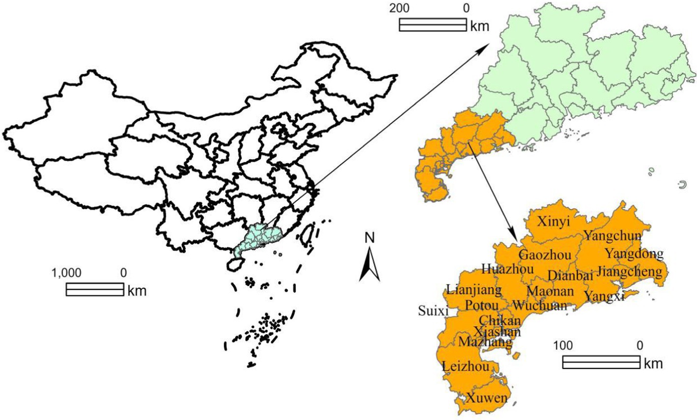
Figure 1. Location map of the study area.
2.1 Data source
The main statistical data comes from the China County Statistical Yearbook, Guangdong Statistical Yearbook, Guangdong Rural Statistical Yearbook, as well as the statistical yearbooks of cities in Guangdong coastal important agricultural areas. At the same time, the regional gross domestic product, agricultural gross domestic product, per capita regional gross domestic product, and per capita disposable income of rural residents will be converted into 2013 comparable prices to eliminate the impact of price fluctuations. The main vector data are from the Ministry of Natural Resources of the People’s Republic of China and the Resource and Environmental Science and Data Center of the Chinese Academy of Sciences. The sample number and regional division of all years are based on 2023 as the unified standard, and relevant data are processed.
2.2 Research methods
In this study, a stepwise regression model was used to analyze the quantitative relationship between cultivated land Transfer and various indicators in important agricultural areas along the coast of Guangdong. Through this model, we can gradually screen out the main factors that have a significant impact on the circulation of cultivated land in sample villages. However, it is worth noting that the stepwise regression model mainly focuses on the individual impact of a single factor on cultivated land Transfer, and cannot fully reveal the complex effects of multiple factors working together (Gonzalez et al., 2021). To compensate for this deficiency, an interaction detection model was further introduced in geographic detectors. This model can effectively analyze the impact of two or more factors on farmland circulation, and provide us with a more comprehensive and in-depth understanding (Guo et al., 2023). By using this model, we can more accurately reveal the interaction between different factors and their comprehensive impact on farmland circulation. In the specific operation, the natural breakpoint method is first used to divide the cultivated land Transfer and its influencing factors into five different categories for hierarchical analysis (Zhang et al., 2022). Through this method, it is possible to see more clearly the impact of different factors on cultivated land Transfer at different levels. Subsequently, geographic detectors were used to detect these factors to determine which ones were the key factors influence the differentiation of cultivated land circulation in the sample villages (Yu et al., 2021).
The geodetector is a statistical method used to detect spatial heterogeneity and reveal its driving factors by detecting spatial differentiation. Here, we focus on the detection of the factors influencing land transfer changes and their interactions using the geodetector (Liu et al., 2024; Anselin, 2010). The calculation formula is as follows:
In the formula 1, h = 1, 2, 3,…, L; L represents the stratification of variables and dependent variables; Representing the discrete variance of the overall space, representing the discrete variance of a certain layer of space; q represents the explanatory power of the influencing factor variable on the dependent variable of cultivated land Transfer, with a larger value indicating a stronger impact (Liu et al., 2023; Bian et al., 2024).
Interaction is a commonly used detection method, which enhances or weakens the effect of variables A and B on cultivated land Transfer Y. The evaluation method first calculates the q-values of variables A and B on the spatial differentiation of cultivated land transfer, denoted as and ; Next, calculate the q-value of the spatial differentiation of cultivated land transfer caused by the combined action of A and B, denoted as; The value range of q is [0–1], and finally compare the size relationship between , , and . The relationship, legend, and results of factor interaction are shown in Table 1.
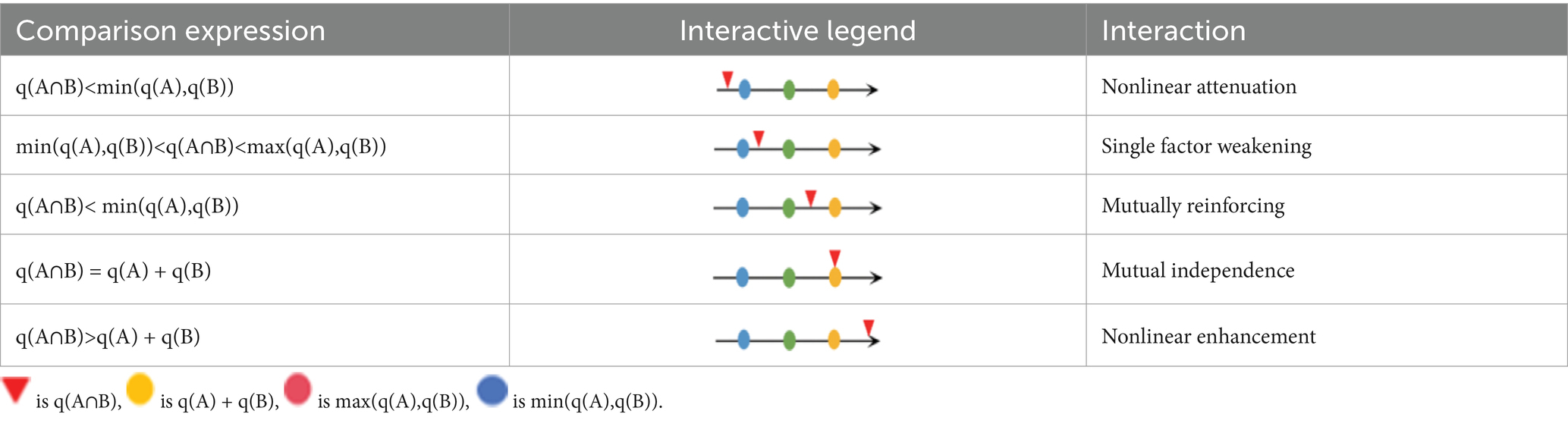
Table 1. Factor interaction relationship.
2.3 Variable selection
At present, there are many studies on land use and spatiotemporal differentiation, forming a relatively mature research system. Agricultural subsidies, cultivated land titling, the size of cultivated land, the use of large-scale machinery, pollution of cultivated land, and farm income all positively affect farming households’ participation in cultivated land transfer (Xu et al., 2023). The use of arable land is influenced by eight indicators, including natural resources, economic development level, natural conditions, production conditions, family livelihoods, adjustment of planting structure, stability of land property rights, and household arable land scale (Zhou et al., 2022). Considering the indicator system established by scholars and combined with the actual situation of important agricultural areas along the coast of Guangdong, the evaluation index system is composed of four primary indicators: production characteristics, economics characteristics, demographic characteristics, and input characteristics, and 14 secondary indicators including cultivated land area and irrigation area. See Table 2 for details.
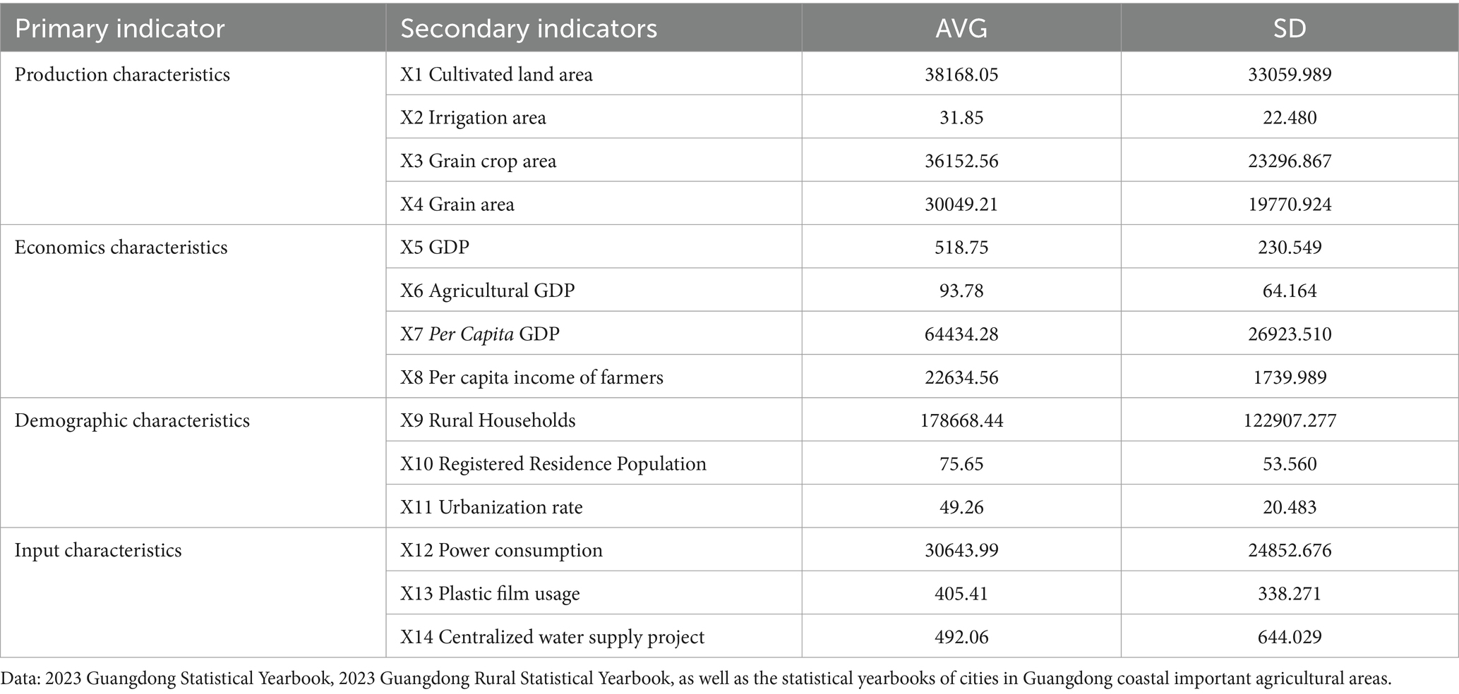
Table 2. Index system for cultivated land transfer.
3 Results and analysis
3.1 Overview of the transfer space of cultivated land along the Guangdong coastal important agricultural areas
In 2023, the coastal areas of Zhanjiang, Maoming, Yangjiang achieved 363452.01 hectares of arable land transfer, accounting for 52.91% of the province’s arable land area. However, due to the dense population in the region, the per capita arable land area is only 0.81 acres, which is higher than Guangdong Province’s 0.23 acres but lower than the national per capita 1.35 acres, highlighting the imbalance between human and land. The transfer of cultivated land in Guangdong coastal important agricultural areas shows significant regional differences, forming a spatial distribution with an increasing amount from east to west. The Zhanjiang, Maoming, Yangjiang area, as an important agricultural development zone along the coast of Guangdong, occupies a significant position in terms of the proportion of comprehensive agricultural output value, grain yield, and regional area. In this context, there are significant differences in the transfer area of cultivated land among different cities: Zhanjiang City leads with a transfer area of 239120.34 hectares, Maoming City follows closely with 88655.13 hectares, and Yangjiang City has a relatively small transfer area of 35676.54 hectares. Further observation at the county level highlights this imbalance even more. The transfer of arable land in western regions such as Suixi, Leizhou, and Lianjiang is relatively active, with Suixi County leading the way with a transfer area of 76597.99 hectares. In contrast, the areas of Jiangcheng, Maonan, Yangchun in the eastern region, as well as Chikan and Xiashan in Zhanjiang City, have relatively small transfer areas, with Chikan District ranking last with only 315.98 hectares of transfer area. The transfer of arable land in Zhanjiang, Maoming, Yangjiang exhibits significant regional imbalances, which not only reflect the socio-economic differences between different regions, but also reveal the complex challenges that the region urgently needs to address in terms of land use and agricultural development.
3.2 Geographical exploration of spatial differentiation in cultivated land transfer
According to the results of stepwise regression analysis (Table 3), we found that the four factors of X2 irrigation area, X5 GDP, X6 agricultural GDP, and X13 plastic film usage passed the test at a significance level of 10%. Meanwhile, X12 power consumption shows a significant impact on cultivated land Transfer at a significance level of 5%. The urbanization rate of X11 and the centralized water supply project of X14 have passed the inspection at the 1% level. Importantly, the VIF values of all 7 variables are less than 5, indicating that there is no serious multicollinearity issue between them, and therefore the regression results are reliable. Further analysis of the standardization coefficient leads us to the following conclusion: the standardization coefficient of X14 rural centralized water supply project reached 0.733, which is the factor with the greatest impact on cultivated land Transfer among these variables. Next are X12, X2, X13, and X11, which also have a significant positive impact on cultivated land Transfer. The X5 GDP and the X6 agricultural GDP have had a certain negative impact on the transfer of cultivated land.
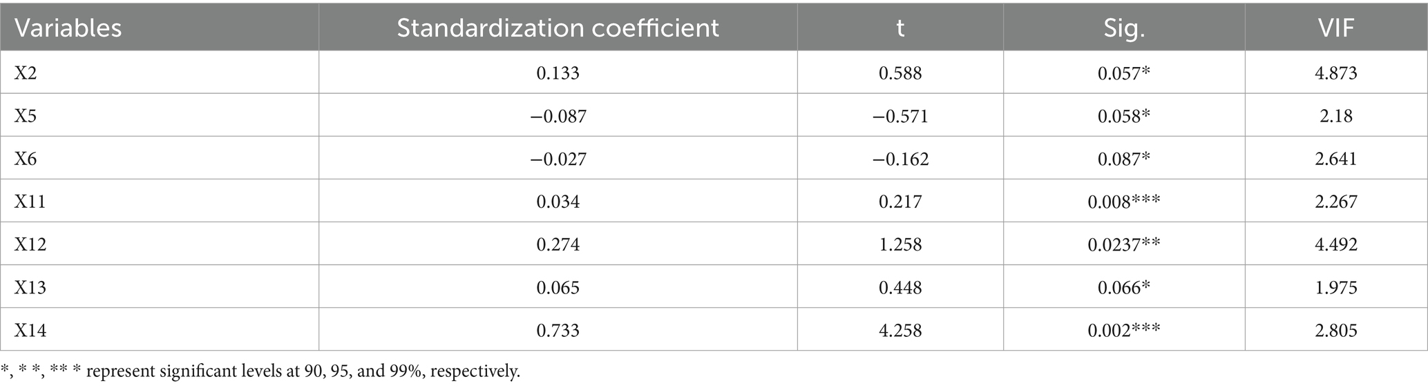
Table 3. Stepwise regression analysis results of influencing factors on cultivated land Transfer.
Figure 2 is a heat map of cultivated land transfer enrichment cycle, divided into 18 fan-shaped plots, representing 18 counties in important agricultural areas along the coast of Guangdong. The stacked bar chart in the outer circle can be interpreted as the distribution of various key indicators (X2 irrigation area, X5 GDP, X6 agricultural GDP, X11 urbanization rate, X12 power consumption, X13 Plastic film usage, X14 centralized water supply project) in different regions or time periods. The middle circle, analogous to log2FC values, can display the relative change multiples of various indicators in different regions or time periods. The inner circle, similar to a dendrogram, can indicate the similarities or differences between key indicators in different regions or time periods of cultivated land Transfer. In 2013, cultivated land Transfer had not yet occurred on a large scale, or the transferred land was mainly used for the increase of irrigation area, while the regional gross product and agricultural gross product were relatively low. By 2018, we can see an increase in both regional production total and agricultural gross product, which may mean that cultivated land Transfer has begun to promote the improvement of agricultural production efficiency, and the increase in mulch usage may reflect the modernization of agricultural production methods. By 2023, the irrigation area further increased, and both regional production total and agricultural gross product also increased. This indicates that the impact between cultivated land Transfer and agricultural production continues to improve, and the agricultural production model is undergoing transformation. Overall, the advancement of urbanization may prompt more farmers to transfer out their land, and effective management of energy and water resources is crucial for maintaining agricultural production.
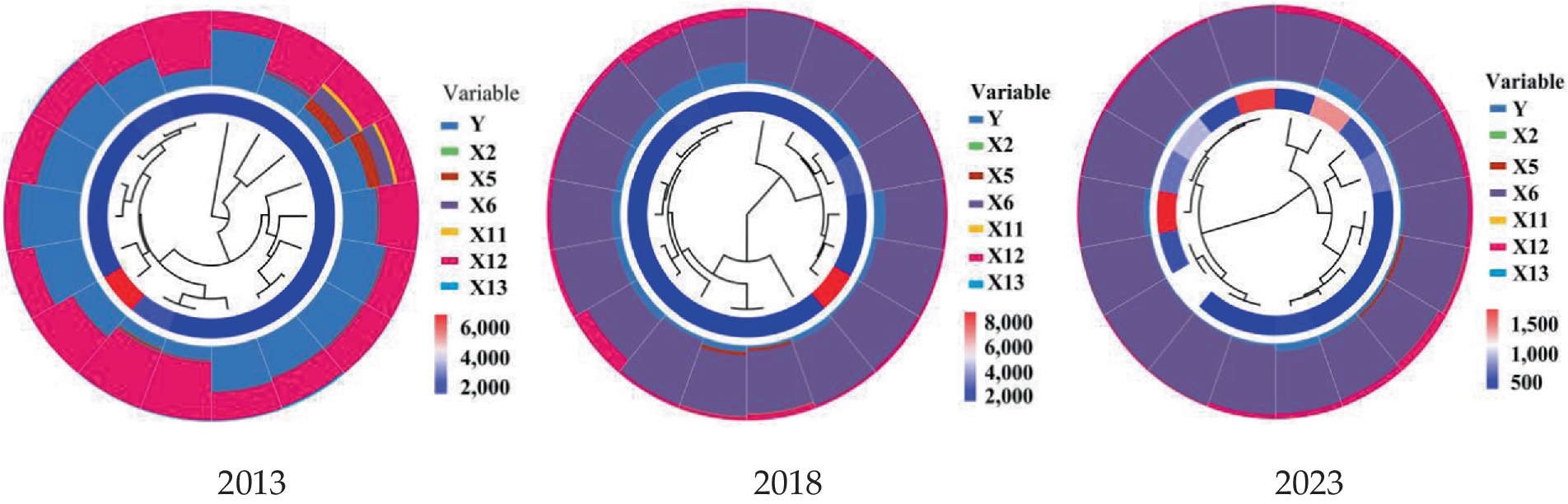
Figure 2. Cultivated land transfer enrichment circular heat map 2013–2023.
Using ArcGIS Pro to classify the influencing factors using the natural breakpoint method, the influencing factors are matched with administrative counties in Zhanjiang, Maoming, and Yangjiang to enrich the element values of each county (Marvin et al., 2023; Pei et al., 2024). By using geographic detectors to spatially detect and spatially extend feature values, the detection results of the influencing factors of cultivated land Transfer in important agricultural areas along the coast of Guangdong can be obtained. The geographical detector factor detection in Table 4 indicates that the independent variables affecting cultivated land Transfer are ranked in order of explanatory power (q value), namely centralized water supply projects, irrigation area, agricultural GDP, urbanization rate, power consumption, plastic film usage, and GDP. From the perspective of the types of influencing factors, the impact of production characteristics and input characteristics on the spatial differentiation of cultivated land Transfer is significantly stronger than that of demographic characteristics and economics characteristics.
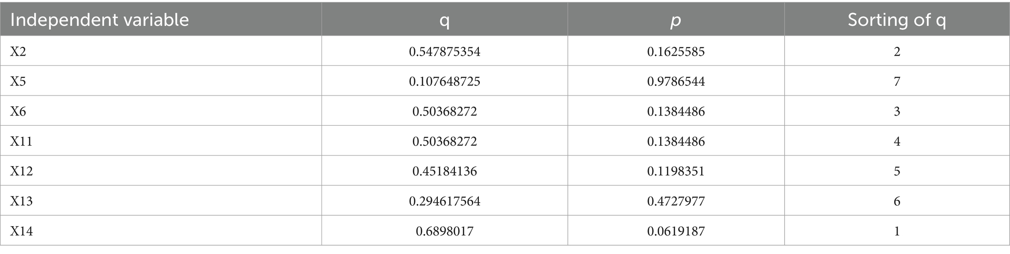
Table 4. Ranking of explanatory power (q) of influencing factors on spatial differentiation of cultivated land Transfer.
By using the factor detection function in the geographic detector, the impact of seven individual factors on the transfer of cultivated land in Zhanjiang, Maoming and Yangjiang was obtained. However, the transfer of cultivated land is the result of multiple factors working together. Further, the interactive detection function in the geographic detector is used to search for the degree of influence of the two factors on the joint effect of cultivated land transfer. The interactive detection results are shown in Figure 3. The interaction between the X5 GDP and X14 centralized water supply project, X2 irrigation area, and X13 plastic film usage is the most significant, and X14 has the most significant impact on other influencing factors. This is because economic development drives the demand for water resources, promotes the construction of water supply projects, and thus affects the transfer of arable land. The close relationship between irrigation area and the amount of plastic film used reflects the modernization of agricultural production methods. Effective irrigation improves farmland output, while the plastic film usage further promotes crop growth. Together, the two promote farmland circulation (Kousar and Abdulai, 2016). The centralized water supply project has a significant impact on other factors, demonstrating the core position of water resources in agricultural production.

Figure 3. Explanatory power under factor interaction.
Further determine the relationship between the interaction of two factors and the q value of a single factor, as shown in Table 5. It was found that the q-values of the dual factor interaction were all greater than those of the single factor interaction, and all showed a dual factor enhanced or non-linear enhanced interaction relationship (Gartaula et al., 2012). There was no independent, single factor weakened or non-linear weakened relationship, indicating that the interaction of factors can enhance the explanatory power of factors affecting cultivated land Transfer.
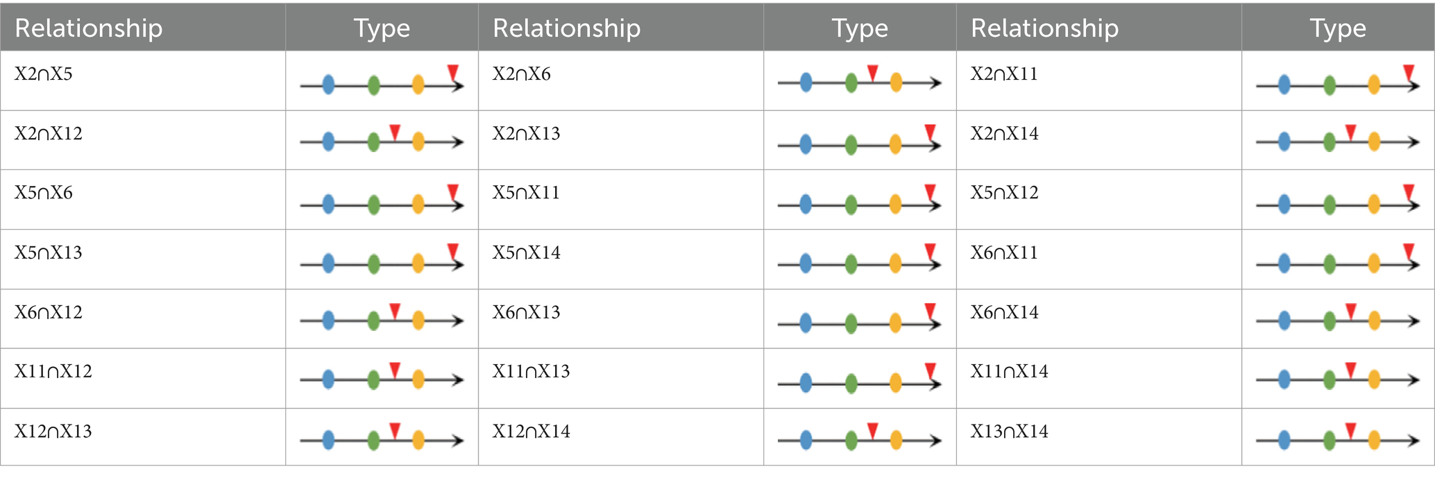
Table 5. Results of dual factor detection.
In order to analyze the results of the interaction between a single factor and other factors in more detail, the difference can be further plotted as a double factor enhanced curve based on the data in Table 5 (Kawagoe et al., 1988). Such as Figure 4, the blue curve with a circular endpoint represents q(X2∩Xn)-q(X2), and the meanings of the other curves are similar, as shown in Figure 3. The superposition effect of X5 and X13 as single factors with other influencing factors is significantly enhanced, while the explanatory power of X5 GDP is only 0.1076, and the explanatory power of X13 plastic film usage is only 0.2946. This indicates that the explanatory power of GDP and plastic film usage on cultivated land Transfer is relatively small, but the explanatory power is significantly enhanced under the combined effect of other factors, which enriches the previous research results of scholars on the relationship between cultivated land Transfer, agricultural investment, and economic development.

Figure 4. Enhanced effect of dual factor interaction.
4 Discussion
4.1 The influence factors of cultivated land transfer
The factors greater than 0.9 in the two factor interaction are X2∩X13, X5∩X14, X12∩X14, X6∩X14, X6∩X14, X11∩X13, X11∩X14. According to the frequency and value of occurrence, the centralized water supply project X14 and plastic film usage X13 in the agricultural investment dimension, the X11 urbanization rate in the demographic characteristics, the X6 agricultural GDP in the economics characteristics, and the X2 irrigation area in the production characteristics are the main influencing factors of cultivated land Transfer in important coastal agricultural areas of Guangdong. The explanatory power of their interaction is strong. In the single factor impact analysis, the explanatory power of X11 and X13 in the input characteristics is very weak, but after the interaction of two factors, the explanatory power of the input characteristics has significantly improved. The geographical detector revealed that the spatial differentiation of cultivated land Transfer in Zhanjiang, Maoming, Yangjiang is the result of the combined effects of production characteristics, economics characteristics, demographic characteristics, and input characteristics. Plotting the 7 indicators selected for explanatory power ranking in Table 4, it is found that the dual factor interaction of part labels b and e in Figure 5 have insufficient explanatory power. Therefore, only part labels a, c, d, f, and g in Figure 5 will be discussed.
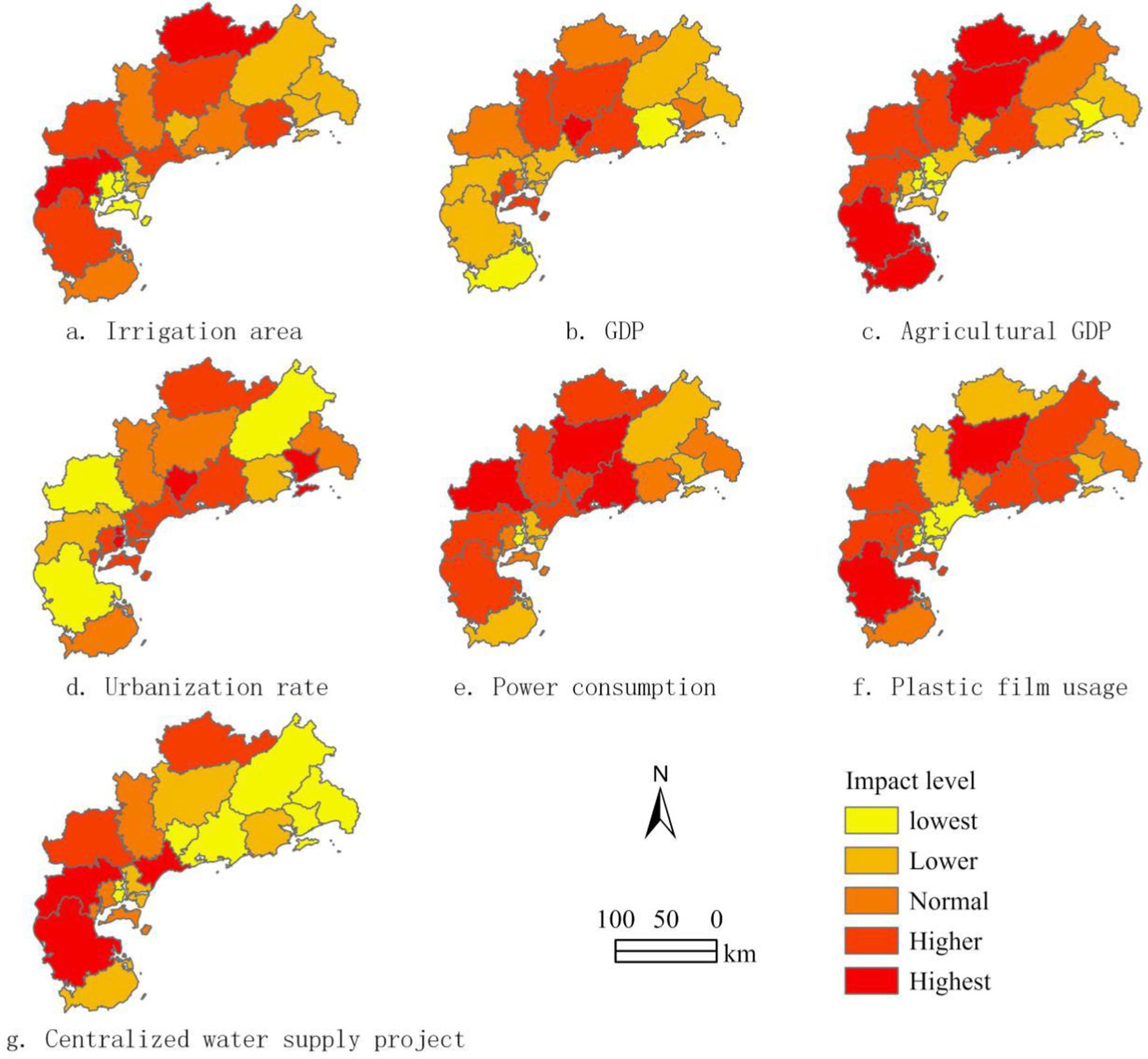
Figure 5. Classification chart of factors affecting cultivated land transfer.
4.1.1 X2 irrigation area
Figure 5a shows that the irrigation area is scattered, with the most concentrated areas being Suixi, Wuchuan in Zhanjiang City, and Xinyi in Maoming. The expansion of irrigation area means that the conditions for agricultural production are improved, which can stabilize and increase the yield and quality of agricultural products. This increases the economic value of land, making farmers more willing to transfer the land and thus obtain higher economic benefits. The expansion of irrigation area helps to promote large-scale agricultural management. Through land transfer, land can be concentrated in the hands of capable and skilled growers or agricultural enterprises, achieving intensive and efficient use of land and improving the overall efficiency of agriculture. The improvement of irrigation area also helps to promote the diversified development of rural economy. Through land transfer, farmers can break free from the constraints of traditional agriculture, participate in other industries, broaden their sources of income, and improve their living standards.
4.1.2 X6 agricultural GDP
Figure 5c shows the distribution trend of agricultural GDP, showing a trend of spreading outward from the center. The highest areas are concentrated in Xuwen and Leizhou in Zhanjiang City, as well as Gaozhou and Xinyi in Maoming City. The increase in agricultural GDP reflects the increase in agricultural production efficiency. With the advancement of agricultural production technology and the improvement of agricultural modernization level, the yield and quality of agricultural products have been significantly improved, thereby increasing the economic value of land. Farmers, seeing the high returns on land, are naturally more inclined to transfer the land and obtain higher economic benefits. The growth of agricultural GDP has also promoted the adjustment and optimization of agricultural industrial structure. This includes promoting the integrated development of the primary, secondary, and tertiary industries in rural areas, and forming a more efficient and diversified agricultural production system. In this context, land transfer has become an important means of promoting agricultural industry upgrading and rural economic transformation. Through land transfer, land can be more efficiently allocated to high-quality projects and advantageous industries, further enhancing agricultural gross domestic product. The increase in agricultural GDP has also brought about an increase in farmers’ income. The increase in farmers’ income makes them more capable of land transfer, thereby accelerating the process of agricultural land transfer. At the same time, with the diversification of farmers’ income, their dependence on land gradually decreases, which also creates more favorable conditions for the transfer of agricultural land.
4.1.3 X11 urbanization rate
Figure 5d shows the characteristic of high urbanization rate in the main urban area. With the increase of urbanization rate, the urban population continues to increase, and the demand for land also increases accordingly. This has promoted the transfer of rural land around cities to meet the demand for land resources due to urban expansion and population growth. This land transfer not only provides more construction land for cities, but also promotes the rational allocation and efficient utilization of rural land resources. The increase in urbanization rate has driven the development of rural economy. With the advancement of urbanization, the industrial structure, employment structure, and lifestyle in rural areas have undergone profound changes. More and more farmers are choosing to work or start businesses in cities, and their land management rights are also being transferred out. This land transfer provides farmers with more sources of income and promotes the diversified development of rural economy. The increase in urbanization rate has also promoted the process of agricultural modernization. With the deepening of urbanization, traditional agricultural production methods have become difficult to meet the needs of modern society. Through land transfer, large-scale management and modernization of land can be achieved, improving agricultural production efficiency and product quality. This helps to promote the development of agriculture to a higher level and achieve a positive interaction between agriculture and cities.
4.1.4 X13 plastic film usage
Figure 5f shows a trend of high usage of plastic film in agricultural counties in the southwest and central regions, concentrated in Leizhou, Xuwen, and Gaozhou in Maoming, Zhanjiang. As an important agricultural production material, plastic film is widely used to increase soil temperature, maintain soil moisture, improve soil quality, and increase crop yield. By covering with plastic film, crops can grow in a more favorable growth environment, improve yield and quality, and thus increase the economic value of the land. With the increase of plastic film usage, agricultural production efficiency also improves, and farmers’ expectations of land benefits also increase. This leads to more farmers being willing to transfer their land to obtain higher economic returns. At the same time, for large growers or agricultural enterprises who intend to expand their production scale, they are also more willing to obtain more land resources through land transfer to achieve large-scale operation and improve production efficiency. The increase in the use of plastic film has also driven innovation and upgrading of agricultural production technology. With the improvement of types and performance of plastic films, agricultural production methods are gradually moving towards efficiency, environmental protection, and sustainability (Ma et al., 2018). This technological innovation and upgrading have also promoted the activity of agricultural land transfer, enabling more rational allocation and utilization of land resources.
4.1.5 X14 centralized water supply project
The number of centralized water supply project in Figure 5g shows an increasing trend from northeast to southwest within the region, concentrated in Suixi, Xuwen, and Wuchuan in Zhanjiang. The increase in the number of centralized water supply projects directly enhances the water resource guarantee capacity of agricultural production. In the agricultural production areas along the coast of Guangdong, water is the lifeline of agricultural production, especially for crops such as rice and vegetables that require a lot of irrigation. The centralized water supply project can provide stable and reliable water sources, ensure sufficient irrigation of farmland, and thus improve the yield and quality of crops. This increase in productivity reduces the dependence of farmers on land and makes them more willing to transfer land to achieve optimal allocation of land resources. The construction of centralized water supply projects often accompanies the improvement of agricultural infrastructure. These projects not only provide water sources, but may also include supporting facilities such as water pipelines, pumping stations, and water storage facilities, significantly improving agricultural production conditions. This improvement reduces the risks and costs of agricultural production, increases the economic value of land, and attracts more social capital to invest in agricultural production, further promoting the process of cultivated land Transfer. The increase in the number of centralized water supply projects has also promoted the scale and intensive development of agricultural production (Smith et al., 2012). With guaranteed water resources, farmers or agricultural enterprises can more confidently expand their planting areas or introduce efficient water-saving irrigation technologies to achieve maximum scale and efficiency in agricultural production. This large-scale operation often requires more land resources, which also promotes the activity of cultivated land Transfer.
In summary, production characteristics, economics characteristics, demographic characteristics, and input characteristics are important factors driving the transfer of cultivated land in important coastal agricultural areas of Guangdong (Larcher et al., 2019; Ustaoglu and Collier, 2018). In particular, the centralized water supply project and the plastic film usage in the input characteristics show the strongest performance; The demographic characteristics represented by urbanization rate has a strong impact and belongs to second class intensity; The economics characteristics represented by agricultural GDP has a weak impact and belongs to third class intensity; The production characteristics represented by irrigation area has the weakest impact and belongs to the fourth class intensity.
4.2 The evolution trend of cultivated land transfer
Figure 6 shows the spatiotemporal changes in cultivated land Transfer in Zhanjiang, Maoming, and Yangjiang in 2013, 2018, and 2023. The overall transfer rate increased from 38.69% in 2013 to 46.72% in 2018, and then to 52.89% in 2023. The most concentrated type of area has not changed and is concentrated in Suixi County, Zhanjiang. Leizhou, Lianjiang, and Wuchuan, which are relatively concentrated in the second category of Zhanjiang City, have not changed, while Gaozhou and Dianbai in Maoming have withdrawn from these two categories of areas. Among the three general types of cultivated land transfer areas, Xinyi in Maoming City has been added; The four areas with weaker cultivated land Transfer have added Mazhang District in Zhanjiang City and Jiangcheng District in Yangjiang City. The scope of the five areas with the weakest circulation has greatly decreased, from 5 in 2013 to 3 in 2018, and then to 2 in 2023, leaving only Chikan District and Xiashan District in Zhanjiang City. Overall, In the Guangdong coastal important agricultural areas, the phenomenon of cultivated land transfer has gone through a process of first increasing and then slowing down. The western region is still the main concentration area for farmland transfer, but it is worth noting that the difference in transfer activity between the central and eastern regions is gradually converging, and the imbalance of transfer has been alleviated.
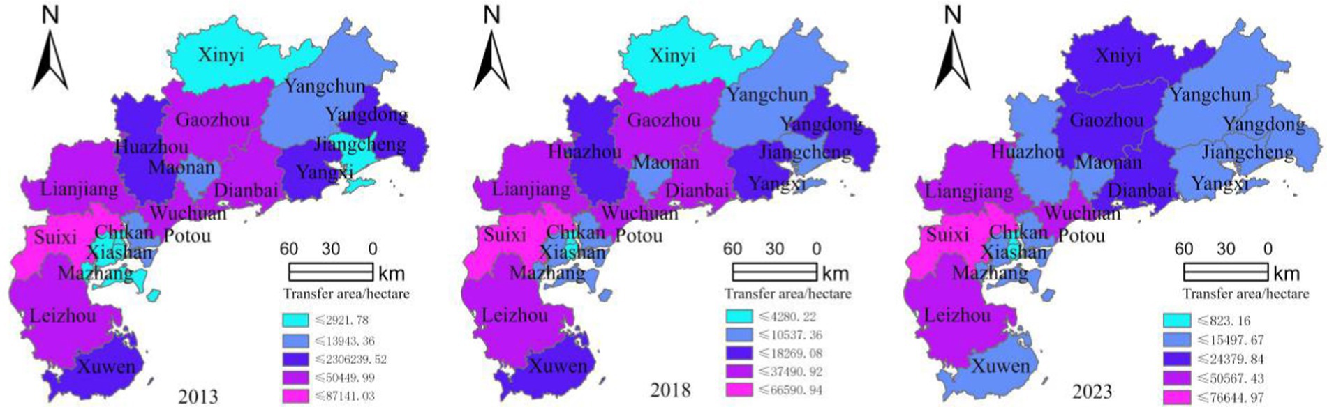
Figure 6. Classification chart of factors affecting cultivated land transfer.
4.3 Measures to promote the transfer of cultivated land in important coastal agricultural areas of Guangdong province
The transfer of cultivated land based on Zhanjiang, Maoming, and Yangjiang is the result of the combined effects of production characteristics, economics characteristics, demographic characteristics, and input characteristics. To promote the transfer of cultivated land in important coastal agricultural areas of Guangdong, the following measures are proposed.
4.3.1 Improve land transfer policies
Including land transfer subsidies and tax incentives, providing certain financial subsidies to reduce the cost of land transfer for farmers. At the same time, by reducing taxes related to land transfer, we encourage the liquidity of land. Clarify the transfer rights and protect the rights and interests of farmers: ensure that the rights and interests of farmers are not harmed during the land transfer process, clarify the rights and responsibilities in the transfer contract, and resolve potential disputes (Loureiro, 2009; Yang et al., 2022).
4.3.2 Improve agricultural production efficiency
Considering the significant impact of X2 irrigation area, it is necessary to improve agricultural production efficiency in order to increase farmers’ enthusiasm for land transfer. Through technical training and support, provide farmers with technical training and modern agricultural technology support, enabling them to more effectively manage land transfer and increase yields. Promote efficient agricultural practices and encourage farmers to adopt high-yield, efficient, and eco-friendly agricultural practices, such as precision agriculture and organic agriculture. Encourage farmers to engage in diversified agricultural production, including food, fruits, vegetables, etc., to reduce risks and increase income (McCartney and Lefsrud, 2018).
4.3.3 Develop rural economy
Given the significant increase in X6 agricultural GDP, it is necessary to develop rural economy in order to reduce the dependence of rural population on land. Including supporting the development of rural industries, supporting the development of rural enterprises and cooperatives, and improving the source of income for rural populations. Create employment opportunities and alleviate land pressure by attracting industrial investment and developing rural tourism.
4.3.4 Increase agricultural investment
Considering the significant input characteristic indicators such as X13 and X14, it is necessary to increase agricultural investment in order to improve land quality and strengthen sustainable land use. Invest in rural infrastructure, including centralized water supply projects and road construction, to improve rural living standards and reduce farmers’ dependence on land (Liu et al., 2021). Support land consolidation and improvement projects, improve land fertility and output, and increase the sustainability of land use.
4.3.5 Improve urbanization rate
Due to the significant urbanization rate of X11, the urbanization process of important coastal agricultural areas in Guangdong should be accelerated. A large number of rural laborers have transferred to cities, reducing direct dependence on rural land and promoting the circulation of idle or underutilized land (Cassman and Grassini, 2020). The increase in urbanization rate has also driven the development of the rural land transfer market, enhanced the standardization and activity of land transfer, provided favorable conditions for agricultural scale and modern operation, optimized land resource allocation, and promoted rural economic transformation and upgrading (Suweis et al., 2015).
4.3.6 Establish and develop a land transfer market
In order to improve the efficiency and transparency of land transfer, it is necessary to establish a land transfer market (Barnabas et al., 2008). Develop the land transfer market, ensure information transparency and fair competition, and reduce transaction costs of transfer. Establish a registration agency for agricultural land transfer, supervise the legality and enforceability of land transfer contracts, and safeguard the rights and interests of both parties to the contracts (Matthew et al., 2016).
5 Conclusion and limitations
5.1 Conclusion
This article uses stepwise regression model and geographic detector methods to analyze the Spatial differentiation characteristics of cultivated land transfer in important agricultural areas along the coast of Guangdong Province, and explores its influence factors. The research results are as follows:
In 2023, the coastal areas of Zhanjiang, Maoming, and Yangjiang achieved 363452.01 hectares of arable land transfer, accounting for 52.91% of the province’s arable land area. However, due to the dense population in the region, the per capita arable land area is only 0.81 acres, which is higher than Guangdong Province’s 0.23 acres but lower than the national per capita 1.35 acres, highlighting the imbalance between human and land. The transfer of cultivated land in Zhanjiang, Maoming, and Yangjiang shows significant regional differences, forming a spatial distribution pattern that increases from east to west. From the timeline of 2013–2023, the transfer of cultivated land in Zhanjiang, Maoming, and Yangjiang decreased first and then increased. The transfer of cultivated land is still in the western regions such as Zhanjiang, while the differences in transfer between Maoming and Yangjiang in the central and eastern regions tend to narrow, and the imbalance in Guangdong coast important agricultural areas is weakening.
In single factor analysis, the explanatory power of indicators such as irrigation area, agricultural GDP, urbanization rate, power consumption, and centralized water supply project is greater than 0.4, indicating that these indicators play an important role in cultivated land Transfer. The impact of production characteristics and economics characteristics on the spatial differentiation of cultivated land Transfer is stronger than that of demographic characteristics and input characteristics.
Under the dual factor interaction, centralized water supply projects, plastic film usage, urbanization rate, agricultural GDP and irrigation area are the main influencing factors of cultivated land Transfer in important coastal agricultural areas of Guangdong. The impact of these indicators is significantly improved compared to single factors under the dual factor interaction, and other indicators also show significant improvement. The dual factor interaction can better explore the relationship between the influencing factors of cultivated land Transfer and comprehensively confirm the influencing factors.
The transfer of cultivated land in important agricultural areas along the coast of Guangdong is the result of production characteristics, economics characteristics, demographic characteristics, and input characteristics. It is necessary to improve the efficiency of cultivated land transfer and alleviate the passive situation of insufficient per capita cultivated land.
5.2 Limitations
Despite the in-depth analysis of the spatial differentiation characteristics of cultivated land transfer in the important agricultural areas along the Guangdong coast and the exploration of its influencing factors using the stepwise regression model and geodetector method, this study still has certain limitations. Firstly, in terms of data collection, although this study integrates statistical data from various aspects as much as possible, difficulties in obtaining some data or limitations in timeliness may result in the analysis results not fully reflecting the latest actual situation. Secondly, in terms of research methods, although the stepwise regression model and geographical detector method have certain advantages in studying cultivated land transfer, they may still be limited by factors such as model assumptions and variable selection, thereby affecting the accuracy and universality of the results. Furthermore, this study mainly focuses on the impact of production characteristics, economics characteristics, demographic characteristics, and input characteristics on cultivated land transfer, but may have overlooked other potential important factors, such as the policy environment and social culture, which may also have a significant impact on cultivated land transfer. Therefore, future research needs to further improve data collection, optimize research methods, and comprehensively consider more factors that may affect cultivated land transfer to enhance the accuracy and comprehensiveness of the research.
Data availability statement
The original contributions presented in the study are included in the article/Supplementary material, further inquiries can be directed to the corresponding author.
Author contributions
ZF: Conceptualization, Formal analysis, Funding acquisition, Investigation, Methodology, Project administration, Writing – original draft, Writing – review & editing. QX: Data curation, Methodology, Resources, Software, Writing – original draft, Writing – review & editing.
Funding
The author(s) declare that financial support was received for the research, authorship, and/or publication of this article. The paper is supported by the Guangdong Province Soft Science Project (2024A1010010016), and the Guangdong Province Philosophy and Social Science Planning Project (GD24CYJ40), and the Guangdong Basic and Applied Basic Research Foundation under Grant (2023A1515011616).
Conflict of interest
The authors declare that the research was conducted in the absence of any commercial or financial relationships that could be construed as a potential conflict of interest.
Generative AI statement
The author(s) declare that no Gen AI was used in the creation of this manuscript.
Publisher’s note
All claims expressed in this article are solely those of the authors and do not necessarily represent those of their affiliated organizations, or those of the publisher, the editors and the reviewers. Any product that may be evaluated in this article, or claim that may be made by its manufacturer, is not guaranteed or endorsed by the publisher.
Supplementary material
The Supplementary material for this article can be found online at: https://www.frontiersin.org/articles/10.3389/fsufs.2025.1529750/full#supplementary-material
References
Ahmad, D., Afzal, M., and Rauf, A. (2020). Environmental risks among rice farmers and factors influencing their risk perceptions and attitudes in Punjab, Pakistan. Environ. Sci. Pollut. Res. 27, 21953–21964. doi: 10.1007/s11356-020-08771-8
Anselin, L. (2010). Local indicators of spatial association-LISA. Geogr. Ann. Ser. B, Hum. Geogr. 27, 93–115. doi: 10.1111/j.1538-4632.1995.tb00338.x
Barnabas, B., Jager, K., and Feher, A. (2008). The effect of drought and heat stress on reproductive processes in cereals. Plant Cell Environ. 31, 11–38. doi: 10.1111/j.1365-3040.2007.01727.x
Battese, G. E., and Coelli, T. (1995). A model for technical inefficiency effects in a stochastic frontier production function for panel data. Empir. Econ. 20, 325–332. doi: 10.1007/BF01205442
Bian, R., Zhao, A., Zou, L., Liu, X., Xu, R., and Li, Z. (2024). Simulation and prediction of land use change and carbon emission under multiple development scenarios at the City level: a case study of Xi’an, China. Land 13:1079. doi: 10.3390/land13071079
Cassman, K. G., and Grassini, P. (2020). A global perspective on sustainable intensification research. Nat. Sustain. 3, 262–268. doi: 10.1038/s41893-020-0507-8
Chen, Y., Qin, Y., and Zhu, Q. (2023). Study on the impact of social capital on agricultural land transfer decision: based on 1017 questionnaires in Hubei Province. Land 12:861. doi: 10.3390/land12040861
Cook, W., Liang, L., and Zhu, J. (2010). Measuring performance of two-stage network structures by DEA: a review and future perspective. Omega 38, 423–430. doi: 10.1016/j.omega.2009.12.001
Fan, S., and Chan-Kang, C. (2005). Is small beautiful? Farm size, productivity, and poverty in Asian agriculture. Agric. Econ. 32, 135–146. doi: 10.1111/j.0169-5150.2004.00019.x
Gartaula, H., Niehof, A., and Visser, L. (2012). Shifting perceptions of food security and land in the context of labour out-migration in rural Nepal. Food Secur. 4, 181–194. doi: 10.1007/s12571-012-0190-3
Gonzalez, E. B., Easdale, M. H., and Sacchero, D. M. (2021). Socio-technical networks modulate on-farm technological innovations in wool production of North Patagonia, Argentina. J. Rural. Stud. 83, 30–36. doi: 10.1016/j.jrurstud.2021.02.015
Guo, Q., Lai, X., Jia, Y., and Wei, F. (2023). Spatiotemporal pattern and driving factors of carbon emissions in Guangxi based on geographic detectors. Sustain. For. 15:15477. doi: 10.3390/su152115477
Kawagoe, T., Hayami, Y., and Ruttan, W. R. (1988). The intercountry agricultural production function and productivity differences among countries: reply. J. Dev. Econ. 28, 125–126. doi: 10.1016/0304-3878(88)90019-3
Kousar, R., and Abdulai, A. (2016). Off-farm work, land tenancy contracts and investment in soil conservation measures in rural Pakistan. Aust. J. Agr. Resour. Econ. 60, 307–325. doi: 10.1111/1467-8489.12125
Larcher, M., Engelhart, R., and Vogel, S. (2019). Agricultural professionalization of Austrian family farm households: the effects of vocational attitude, social capital and perception of farm situation. Ger. J. Agric. Econ. 68, 28–44. doi: 10.52825/gjae.v68i1.2123
Li, B., and Shen, Y. (2021). Effects of land transfer quality on the application of organic fertilizer by large-scale farmers in China. Land Use Policy 100:105124. doi: 10.1016/j.landusepol.2020.105124
Li, L., Zheng, S., Zhao, K., Shen, K., Yan, X., and Zhao, Y. (2022). The quantitative impact of the arable land protection policy on the landscape of farmland abandonment in Guangdong Province. Remote Sens. 14:4991. doi: 10.3390/rs14194991
Lichtenberg, E., and Ding, C. (2008). Assessing farmland protection policy in China. Land Use Policy 25, 59–68. doi: 10.1016/j.landusepol.2006.01.005
Liu, W., Chen, Y., He, X., Mao, P., and Tian, H. (2021). Is current research on how climate change impacts global food security really objective? Food Secur. 10:2342. doi: 10.3390/foods10102342
Liu, Y., Lin, Y., Liu, W., Zhou, J., and Wang, J. (2024). Remote sensing perspective in exploring the spatiotemporal variation characteristics and post-disaster recovery of ecological environment quality, a case study of the 2010 Ms7.1 Yushu earthquake. Geomat. Nat. Haz. Risk 15:578. doi: 10.1080/19475705.2024.2314578
Liu, Y., Lin, Y., Wang, F., Xu, N., and Zhou, J. (2023). Post-earthquake recovery and its driving forces of ecological environment quality using remote sensing and GIScience, a case study of 2015 Ms8.1 Nepal earthquake. Geomat. Nat. Haz. Risk 14:496. doi: 10.1080/19475705.2023.2279496
Liu, Y., Wang, C., Tang, Z., and Nan, Z. (2018). Will cultivated land transfer reduce grain acreage? Evidence from Gansu province, China. China Agric. Econ. Rev. 10, 277–292. doi: 10.1108/CAER-04-2017-0072
Loureiro, M. L. (2009). Farmers’ health and agricultural productivity. Agric. Econ. 40, 381–388. doi: 10.1111/j.1574-0862.2009.00385.x
Ma, D., Chen, L., Qu, H., Wang, Y., Misselbrook, T., and Jiang, R. (2018). Impacts of plastic film mulching on crop yields, soil water, nitrate, and organic carbon in northwestern China: a meta-analysis. Agric. Water Manag. 202, 166–173. doi: 10.1016/j.agwat.2018.02.001
Ma, L., Zong, Y., Wang, X., Shi, Z., and Zhang, W. (2024). Farmland use behavior and its influencing factors from the perspective of population migration. J. Geogr. Sci. 34, 439–458. doi: 10.1007/s11442-024-2212-4
Marvin, D., Sleeter, B., Cameron, D., Nelson, E., and Plantinga, A. (2023). Natural climate solutions provide robust carbon mitigation capacity under future climate change scenarios. Sci. Rep. 13:19008. doi: 10.1038/s41598-023-43118-6
Matthew, H., Hoshika, Y., and Killi, D. (2016). Has the impact of rising CO2 on plants been exaggerated by Meta-analysis of free air CO2 enrichment studies? Front. Plant Sci. 7, 1–4. doi: 10.3389/fpls.2016.01153
McCartney, L., and Lefsrud, M. G. (2018). Protected agriculture in extreme environments: a review of controlled environment agriculture in tropical, arid, polar, and urban locations. Appl. Eng. Agric. 34, 455–473. doi: 10.13031/aea.12590
Mengü, G. P., and Akkuzu, E. (2010). Impact of irrigation management transfer on land and water productivity and water supply in the Gediz Basin, Turkey. J. Irrig. Drain. Eng. 136, 300–308. doi: 10.1061/(ASCE)IR.1943-4774.0000191
Morais, P., and Camanho, A. (2011). Evaluation of performance of European cities with the aim to promote quality of life improvements. Omega 39, 398–409. doi: 10.1016/j.omega.2010.09.003
Nguyen, T., Chen, E., and Findlay, C. (1996). Land fragmentation and farm productivity in China in the I990s. China Econ. Rev. 7, 169–180. doi: 10.1016/S1043-951X(96)90007-3
Pei, X., Zheng, X., and Wu, C. (2024). How part-time farming affects cultivated land use sustainability: survey-based assessment in China. Land 13:1242. doi: 10.3390/land13081242
Smith, L., Inman, A., and Cherrington, R. (2012). The potential of land conservation agreements for protection of water resources. Environ. Sci. Pol. 24, 92–100. doi: 10.1016/j.envsci.2012.07.017
Song, H., Li, X., Xin, L., and Wang, X. (2024). Do cultivated land transfers mitigate farmland abandonment? ——a case study of China's mountainous areas. Habitat Int. 146:103023. doi: 10.1016/j.habitatint.2024.103023
Suweis, S., Carr, J. A., Maritan, A., Rinaldo, A., and D’Odorico, P. (2015). Resilience and reactivity of global food security. Proc. Natl. Acad. Sci. USA 112, 6902–6907. doi: 10.1073/pnas.1507366112
Ustaoglu, E., and Collier, M. J. (2018). Farmland abandonment in Europe: an overview of drivers, consequences, and assessment of the sustainability implications. Environ. Rev. 26, 396–416. doi: 10.1139/er-2018-0001
Wang, J., Cao, Y., Fang, X., Li, G., and Cao, Y. (2022). Does land tenure fragmentation aggravate farmland abandonment? Evidence from big survey data in rural China. J. Rural. Stud. 91, 126–135. doi: 10.1016/j.jrurstud.2022.03.013
Wang, Z., Li, X., Mao, Y., Li, L., Wang, X., and Lin, Q. (2022). Dynamic simulation of land use change and assessment of carbon storage based on climate change scenarios at the City level: a case study of Bortala, China. Ecol. Indic. 134:108499. doi: 10.1016/j.ecolind.2021.108499
Xu, M. J., Chen, C. L., and Ahmed, M. A. (2024). Market-oriented cultivated land transfer and outsourced machinery services: evidence from China. Econ. Anal. Policy 81, 1214–1226. doi: 10.1016/j.eap.2024.02.014
Xu, H., Fan, Z., Ahmad, F., and Zhang, D. (2023). Exploring the ecological protection impacts of cultivated land transfer: explanation based on fertilizers and pesticides. Ecol. Indic. 154:110681. doi: 10.1016/j.ecolind.2023.110681
Yang, L., Wu, P., and Yang, W. (2022). Characteristics, health risk assessment, and transfer model of heavy metals in the soil—food chain in cultivated land in karst. Food Secur. 11:2802. doi: 10.3390/foods11182802
Yin, K. X., Lan, Q. G., Kan, S. S., and Su, Y. D. (2020). Empirical research on the risk measurement of mortgage loans on rural land contract and management rights: a case study of Heilongjiang Province. J. Coast. Res. 103, 226–230. doi: 10.2112/SI103-049.1
Yu, G., Liu, T., Wang, Q., Li, T., Li, X., Song, G., et al. (2022). Impact of land use/land cover change on ecological quality during urbanization in the lower Yellow River Basin: a case study of Jinan City. Remote Sens. 14:6273. doi: 10.3390/rs14246273
Yu, M., Xu, Y., Li, J., Lu, X., Xing, H., and Ma, M. (2021). Geographic detector-based spatiotemporal variation and influence factors analysis of PM2.5 in Shandong, China. Pol. J. Environ. Stud. 30, 463–475. doi: 10.15244/pjoes/120522
Zhang, C., and Chen, D. (2021). Fragmentation reduction through farmer-led land transfer and consolidation? Experiences of Rice farmers in Wuhan metropolitan area China. Agriculture 11:631. doi: 10.3390/agriculture11070631
Zhang, T., Chen, L., Yu, Z., Zang, J., and Li, L. (2022). Spatiotemporal evolution characteristics of carbon emissions from industrial land in Anhui Province, China. Land 11:2084. doi: 10.3390/land11112084
Keywords: geodetector, guangdong coastal important agricultural areas, land transfer, stepwise regression model, spatial differentiation
Citation: Fu Z and Xue Q (2025) Analysis of the influence factors of cultivated land transfer in Guangdong coastal important agricultural areas based on geodetectors. Front. Sustain. Food Syst. 9:1529750. doi: 10.3389/fsufs.2025.1529750
Edited by:
Idowu Oladele, Global Center on Adaptation, NetherlandsReviewed by:
Yaohui Liu, Shandong Jianzhu University, ChinaOluwasogo Olorunfemi, University of Mpumalanga, South Africa
Copyright © 2025 Fu and Xue. This is an open-access article distributed under the terms of the Creative Commons Attribution License (CC BY). The use, distribution or reproduction in other forums is permitted, provided the original author(s) and the copyright owner(s) are credited and that the original publication in this journal is cited, in accordance with accepted academic practice. No use, distribution or reproduction is permitted which does not comply with these terms.
*Correspondence: Qingyi Xue, eHVlcXk1NTIzQG1haWxzLmpsdS5lZHUuY24=