 Carlos E. González-Orozco
 Raul Alejandro Diaz-Giraldo1
- 1Corporación Colombiana de Investigación Agropecuaria (Agrosavia). Centro de Investigación La Libertad, Villavicencio-Puerto López, Meta, Colombia
- 2Deutsche Gesellschaft für Internationale Zusammenarbeit (GIZ), GmbH., Bogotá, Cundinamarca, Colombia
The eastern high plains of the Orinoco region in Colombia are known as ‘Altillanura’. They are considered the future agricultural frontier of Colombia. Unfortunately, an agricultural expansion without taking in consideration areas of high biodiversity and conservation of fragile ecosystems that are ecologically irreplaceable will likely fail in providing a sustainable grow. An orderly management planning of the territory based on scientific evidence is currently lacking for this region. Specifically, studies that combine biodiversity data and agricultural information are a major research gap. This study analyses the spatial patterns of species richness and endemism of flora and fauna at the site and subregional levels. We compared the spatial changes of biodiversity patterns with aspects related to the expansion of the agricultural frontier and its possible impacts. We found a west-to-east pattern; sites closer to the Andes were more exposed to ecological degradation than those in the east. Santa Rosalía and Puerto Lopez are the municipalities with the most remarkable species diversity. Conversely, La Primavera municipality has the most significant number of endemic species. Our spatial changes results raise the alarm showing that hotspots of diversity closer to the municipalities of Puerto Lopez and Puerto Gaitan are under more pressure than underdeveloped municipalities (La Primavera and Puerto Carreño). Our results could serve as a baseline to identify spatial changes of agrobiodiversity and a guideline for land-use planning, regional policies and local decision-makers to improve regional development in Colombia’s eastern plains region.
Introduction
Colombia is a megadiverse country, home to 314 types of ecosystems and many areas of high biological diversity [Convention on Biological Diversity (CBD), 2022]. The Orinoco eastern high plains (OHP) region is a critical area for social and economic development due to its potential for agricultural expansion. While approximately 156 types of ecosystems are found across the 34,720,853 hectares of the Colombian Orinoco basin (Bustamante, 2019), many of these ecosystems are degraded due to land clearing, with devastating consequences for biodiversity. The OHP encompasses about 10 million hectares in Meta and Vichada. The OHP is part of the savanna biome, and biogeographical studies recognise it as an independent geographic unit for plant communities [Instituto Geográfico Agustín Codazzi (IGAC), 1997; Morrone, 2014; González-Orozco, 2021].
The OHP is characterised by landscapes of well-drained natural savannas, gallery forests, rivers and lagoons that harbour a rich assemblage of species, including 144 endangered and 75 endemic species (Deutsche Gesellschaft für Internationale Zusammenarbeit GmbH [GIZ]; Correa et al., 2006; Rosselli et al., 2022). However, the biodiversity of the OHP is under threat due to large-scale and rapid transformation of ecosystems by agriculture, primarily agroindustry (Andrade et al., 2013; Baptiste et al., 2017; Etter et al., 2020). With vast areas of agricultural frontier classified as a priority for water and forest conservation, understanding the extent of usable land for sustainable human use is challenging. Thus, knowledge of the spatial relationship between biodiversity and agricultural expansion is essential for effective agricultural and environmental policy planning in Colombia’s OHP.
The ecosystems of the OHP are characterised by vast grasslands, wetlands and savannas, which are suitable for livestock farming and agriculture. Cattle ranching is the most important agricultural activity in the region, with over 20 million head of cattle being raised for meat and dairy production. The region is also home to significant areas of oil palm and soybean plantations, which have been expanding rapidly in recent years. Other crops grown in the region include corn, rice, cassava and sorghum.
The OHP also known as the ‘Llanos Orientales’, are characterised by a unique flora and fauna that have adapted to the hot and dry climate of the region. One of the most iconic species of the Llanos is the capybara, the largest rodent in the world, which can be found living near the many rivers and lagoons that run through the region. Other common mammals include deer, jaguars and various species of monkeys. The area is also home to a variety of bird species, such as the scarlet ibis, the jabiru stork and the king vulture, making it a popular destination for birdwatchers. The vegetation of the OHP is mainly composed of grasslands, shrubs and trees that have adapted to the region’s harsh climate, including species such as the Moriche palm and the Yopo tree, which are important to the local indigenous communities for their medicinal and cultural uses. The spatial distribution of many of these flora biodiverse groups are poorly understood in the OHP of Colombia. Consequently, there are profound sampling gaps due to remoteness. Therefore, we need to generate flora and fauna datasets of the OHP and analyse its spatial patterns of species richness and endemism. Richness is important because we can find out where are the greatest number of species. Endemism otherwise refers to how much range restricted are the species.
The biodiversity of the OHP is scarcely studied and under threat due to the large-scale and rapid transformation of ecosystems by agriculture, principally agroindustry (Lavelle et al., 2014; Rosselli et al., 2022; Villegas et al., 2022). In the OHP, many areas are inaccessible and remote, which is one of the main challenges regarding biological surveys and biodiversity analysis. Even the most accessible bioregions of Colombia, such as the Andean biome, experience sampling biases (Vargas et al., 2022). While the Andean bioregions are well studied, due in part to their accessibility, understanding of the more remote, OHP region is lacking. Specifically, data on species distributions and its relationship to agricultural expansion is critically needed to improve understanding of the human impacts on agrobiodiversity. Such knowledge is essential for the effective planning of agricultural and environmental policy in Colombia’s eastern plains. Consequently, if this complex land-use change phenomena and the lack of biological records continue, it will likely lead to biodiversity loss and irreversible changes in the ecosystem’s integrity.
We argue that biodiversity in the OHP requires a better understanding of its spatial relationships to agricultural expansion. The OHP is considered Colombia’s future food basket due to its large, underutilised territories with the potential for cropping. However, a variety of classifications generate different areal estimates. According to GIZ, the agrarian land use area of underutilised crops suggests that around 16 million hectares are apt for 27 sustainable agricultural systems across the whole Orinoquía region [Deutsche Gesellschaft für Internationale Zusammenarbeit GmbH (GIZ), 2020a]. These areas are different to UPRA’s classification because they use other criteria such as ecological structure. For estimates of potential agricultural areas, here we rely mainly on UPRA’s classification. On the other hand, UPRA states that Meta has close to 5 million hectares and Vichada 4.7 m/h apt for developing the agricultural frontier [Unidad de Planificación Rural Agropecuaria (UPRA), 2021].
Thematic maps of crops were generated by Unidad de Planificación Rural Agropecuaria (UPRA) (2021) based on national, regional and local data census for all municipalities in the Orinoquia region. As a result, optimal, marginal and not suitable areas for agriculture were identified. They estimated that about 15.9% of all land in the Orinoquía region is suitable for livestock production and 10% (2.3 million hectares) for agroforestry and forestry systems. Of these, just 1.3 million hectares are suitable for agricultural expansion in Meta department. However, just 1.07 million hectares should be used for agricultural production. In the case of Vichada, 10 million hectares are projected for agriculture, including livestock. Of those, just 1.4 million hectares are recommended as apt for agricultural production.
The agricultural practices in the OHP of Meta and Vichada are heavily influenced by the region’s climate, which is characterised by a wet season and a dry season. During the wet season, which lasts from April to November, the grasslands and wetlands provide abundant grazing for livestock, while crops are planted and harvested during the dry season. Regarding specific farming activities, cattle raising is the primary source of income for the inhabitants, and the predominant food systems are pastures, agroforestry and livestock. The problem is that land use changes caused by agriculture in the OHP are happening fast across the whole eastern plain’s region degrading its native biodiversity and therefore compromising its conservation. Hence, studies investigating the spatial changes between biodiversity and the agricultural frontier are needed.
Besides agricultural expansion and biodiversity loss, the region faces several challenges, including soil erosion, deforestation and the need for improved irrigation and water management systems. Climate change is also a growing concern, as droughts and flooding events have become more frequent in recent years.
To address these challenges, the Colombian government and private sector have been working to promote sustainable agriculture practices, including the use of conservation agriculture techniques, improved water management and the expansion of agroforestry systems. These efforts aim to promote sustainable development and ensure the long-term viability of agriculture in the region. However, lack of science-based information is still a common issue in the region. Here we apply a framework that uses the distribution of existing species records of fauna and flora in the OHP areas where high levels of biodiversity (single hotspots or regions) are found, and agricultural expansion occurs. This approach aims to enable policymakers, civil society leaders and businesses to identify spatial changes of agrobiodiversity and mapped out priority areas of biodiversity to inform regional planning. Therefore, our paper will contribute to bridge the gap knowledge between biodiversity and agriculture in the OHP that could be used to improve environmental planning.
Materials and methods
Study region
The study region is part of Meta and Vichada. It covers the municipalities of Puerto Carreño, La Primavera, Santa Rosalía, Puerto Gaitán and Puerto López (Figure 1). The study region is rich in hydrological systems, which are essential to shaping biodiversity (Instituto Alexander von Humboldt, 2016). The elevational gradient ranges between 50 and 300 metres above sea level. A classification based on hydrological features identified four major zones and eight sub-zones in Puerto Carreño, La Primavera and Santa Rosalía [Instituto de Hidrología, Meteorología y Estudios Ambientales (IDEAM), 2013]. The catchments of the Meta, Orinoco, Bita and Tomo rivers form the hydrological zones. At the micro-catchment level, 31 sub-zones were identified for Puerto Carreño, La Primavera, Santa Rosalía, Puerto Gaitán and Puerto López.

Figure 1. Map of the study region showing the municipalities of Puerto López, Puerto Gaitán, Santa Rosalía, La Primavera and Puerto Carreño.
Rainfall across the region has a monomodal pattern. January to March is the dry season (0–100 mm per month), and the rest of the year, it rains most of the months with an average range between 150 and 500 mm/month. There is a wet-to-dry climate pattern from west to east; Puerto Carreño is the drier and hotter municipality. In contrast, Puerto López in the far west, closer to the Andean mountain range, is cooler and wetter.
Conceptual framework
Figure 2 summarises the variables and activities involved during the application of the proposed conceptual framework.
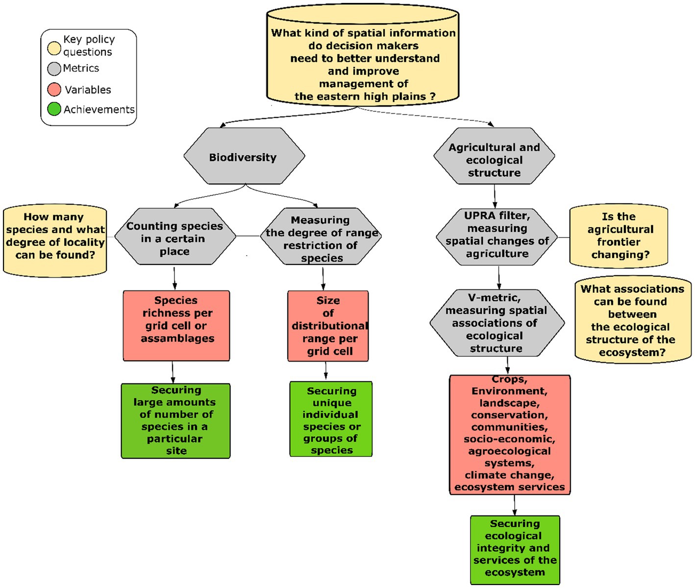
Figure 2. Summary of the conceptual model applied in our study.
Species occurrence data and distribution
Two spatial databases of species occurrences from independent sources were generated. Based on a previously published biodiversity database of Deutsche Gesellschaft für Internationale Zusammenarbeit GmbH (GIZ) (2020a), we built a species-level geographic database with 2,894 occurrences, comprising 2,574 different species records of the Animalia kingdom (insects, birds, mammals, reptiles, amphibious) and 320 different species records of the Plantae kingdom (Liliopsidae and Magnoliopsida; SI Database 1).
Puerto López contain 715 occurrences, Puerto Gaitán 599, Puerto Carreño 323, La Primavera 544 and Santa Rosalía 713. The biological records were extracted from the Global Biodiversity Information Facility (GBIF) and Species Link repositories, initially gathered in the field by the Instituto Alexander von Humboldt (2019). All the occurrences in Database 1 are registered and deposited in the National Biodiversity System (SIB, for its acronym in Spanish). During field survey campaigns, local communities and scientists collected secondary information about regional species distributions [Deutsche Gesellschaft für Internationale Zusammenarbeit GmbH (GIZ), 2020a].
The Deutsche Gesellschaft für Internationale Zusammenarbeit GmbH (GIZ) (2020a) database was developed under a regionally sustainable development strategy and participative community project known as Transformando la Orinoquía con la integración de los beneficios de la naturaleza en agendas sostenibles (Tonina). It can be considered more of a fauna database because 75% of the occurrences are for fauna. This regional classification was proposed by the National Bureau of Meteorology [IDEAM, for its acronym in Spanish, 2013, the physiography classification of the Orinoquía-Amazon (ORAM) developed by the Instituto Geográfico Agustín Codazzi (IGAC) (1999)].
Due to having more fauna records than any other biological group, the second dataset of plant distribution was developed using the Botanical Information and Ecology Network (BIEN) version 4.1 database. The RBIEN package (Maitner et al., 2018) extracted 8,406 occurrences comprising 3,358 species records from BIEN (SI Database 2). The BIEN database provides standardised plant observations from herbarium specimens. The total number of occurrences reported in both datasets was 11,301, comprising 6,254 species.
Sampling completeness
We calculated the sampling completeness indicator known as redundancy using the software BIODIVERSE version 3.1 (Laffan et al., 2010). Redundancy measures the occurrence data density calculated as 1-richness/occurrences (Garcillán et al., 2003). Redundancy ranges between 0 and 1. The closer to 1, the number of samples per grid cell is better represented, suggesting fewer sampling biases in the spatial datasets. The redundancy metric was applied to Deutsche Gesellschaft für Internationale Zusammenarbeit GmbH (GIZ) (2020a) and plant diversity datasets. The degree of sampling completeness is low for most of the study region but moderate to high in the main centres of diversity (Supplementary Figure 2).
Species richness and endemism
A grid-based meta-analysis (multiple biological groups) was performed on both databases across the study region. Species richness (SR) and corrected weighted endemism (CWE) were calculated using the BIODIVERSE software version 0.18 (Crisp et al., 2001) for each 5 × 5 km grid cell. SR is the number of species present in a single grid cell. CWE is a relative measure of endemism and is essentially a function of range restriction (Laffan et al., 2010). CWE can be interpreted as the degree to which species ranges are restricted to a particular location. Areas of high SR or CWE are referred here as centres of diversity. These areas are sites (single or group of grid cells) with high concentration of biodiversity.
Geographic regions
A Range Weighted Turnover (RWT) index was applied using the BIODIVERSE software version 0.18 (Laffan et al., 2016). RWT was applied to both the Deutsche Gesellschaft für Internationale Zusammenarbeit GmbH (GIZ) (2020a) and the BIEN databases independently. Calculating RWT, each species is weighted by the fraction of its geographic range across two locations. A dissimilarity matrix was then created in BIODIVERSE. An RWT score of zero means that the species composition of the two cell pairs is identical, whereas a score of 1 means that the cell pairs are most dissimilar. The endemism-weighted dissimilarity matrix was converted into clusters of distinct species proportional to their range. The range-weighted metric provides better discrimination of the distributional break than the non-range-weighted metrics. The results of the RWT metric are displayed in a coloured map and a dendrogram. The clusters in the dendrogram reflect regions of endemism separated according to geographic distances.
Linking biodiversity and agriculture
An integrated methodological framework that contains GIS layers of management strategies for conserving biodiversity, indicators of the benefits of nature and environmental use and management were used as the baseline information to feed our spatial changes analyses [Deutsche Gesellschaft für Internationale Zusammenarbeit GmbH (GIZ), 2020a]. This framework will map out and quantify the spatial changes of ecological structure based on their level of association across the region.
The inputs of the analyses were the layer of agricultural frontier generated by the Unidad de Planificación Rural Agropecuaria (UPRA) (2021) and the proposal for a Principal Ecological Structure [PES hereafter; Deutsche Gesellschaft für Internationale Zusammenarbeit GmbH (GIZ), 2020b]. Access to the UPRA1 and Humboldt Institute biological databases is granted.2 Note that each municipality has a different source in the previously mentioned sites. This framework considers Puerto Carreño, La Primavera and Santa Rosalia; Puerto Lopez and Puerto Gaitan were not included in this analysis because no PES layer was available.
The PES proposal is a database of cartographic information on ecological infrastructure and its ecosystem services that interconnect the environment, conservation, communities and socio-economic and agroecological systems. The components of the PES are hydrological units, landscape classification, identification of regional priorities and indicators of critical elements across ecosystems, land cover type, participative communal prioritisation of areas of importance, flooding and climate change risk analysis, liability assessment and finally ecosystem services of the three municipalities.
We applied the spatial statistics information-theoretical V-measure to quantify the degree of spatial changes and association between agriculture and biodiversity (Nowosad and Stepinski, 2018). This measure was calculated using ArcGIS Pro geoprocessing tools [Environmental Systems Research Institute (ESRI), 2021]. This index measures the degree of spatial association and changes between two categorical classifications. A high association is when a category is more spatially correlated with another category. The output of this measure is a spatial degree of changes and association between the variables of the categories. This measure generates a scale with values between 0 and 1. One means highly associated, and zero means a low degree of association. This analysis was applied separately for each municipality (Santa Rosalía, La Primavera and Puerto Carreño). However, a mosaic was built to facilitate the visual interpretation. The V-metric output was superposed to the layers of SR and CWE biodiversity hotspots. This way, we could compare the layers of hotspots’ spatial location and agricultural information generated by the V-measure. The areas with a low degree of association suggest less exposure to changes among the agrobiodiversity inputs. In contrast, high degree of association suggests areas potentially exposed to a greater level of changes among inputs causing more spatial overlap of factors that affect biodiversity.
Results
Species richness
We identified three fauna SR centres (1, 2 and 3 in Figure 3A). As ordered in Figure 3, they are (1) the Santa Rosalía Gap, (2) the Manacías, Yucao and Meta rivers and (3) the Guacavia, Guatiquía and upper Meta rivers. Centres 2 and 3 are geographically part of the eastern range foothills tributaries, whereas Centre 1 relates more to the Orinoco system. The highest scores of the main fauna SR centres range between 15 and 17 species, but a single grid cell found an SR maximum value of seven at a threshold of 5–95%. There are several scattered richness grid cells in Puerto Carreño. In the case of plant SR (Figure 3C), the Puerto Carreño region shows the highest values with a maximum of 72 species in a grid cell. There is another centre of plant SR in Puerto Lopez and a few single cells scattered in La Primavera and Santa Rosalía.
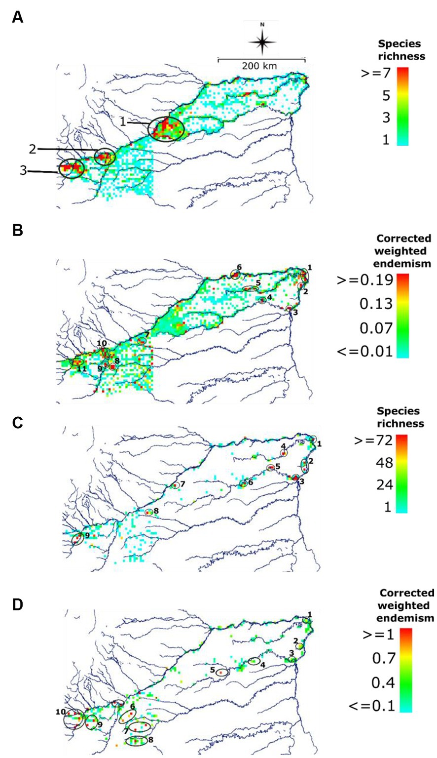
Figure 3. Spatial distribution of biodiversity for fauna (A,B) and plants (C,D) in the Orinoco high plains of Colombia. White areas have no data available. Colour at a threshold of 5–95%.
Endemism
We identified 11 centres of fauna endemism (Figure 3B). There are three centres of fauna endemism; the largest ones are on the east (1–6 in Figure 3B) and west (Puerto López and Puerto Gaitán; 7–11 in Figure 3B). We confirm that Puerto Carreño has the most endemic fauna locations closely related to the river systems, followed by Puerto López and Santa Rosalía. Some of the centres of fauna endemism are unevenly distributed across different regions in the high plains. The highest endemism score for fauna was 0.19 (red grid cells), meaning that these windows (individual or groups of grid cells) represent, on average, 19 per cent of the range of species they contain. The randomisation results show that all identified centres of endemism were significantly different from random at a threshold of α = 0.05 (Supplementary Figure 1).
The spatial distribution of SR and endemism for plants show different patterns and a higher degree of endemism than the fauna dataset. The main centres of plants SR (1–6 in Figure 3C) are Puerto Carreño. In contrast, the western regions of Puerto Lopez and Puerto Gaitán showed the most significant number of sites with high endemism (6–11 in Figure 3D). However, a few scattered areas of high endemism are present in Puerto Carreño.
Geographic regions
A strategy to improve the interpretation of endemism was to identify the turnover regions based on the degree of distributional range (Figure 4). This analysis helped to validate the spatial endemism patterns found at the individual grid cell level. Two major biogeographical fauna regions were identified in the OHP (Figure 4A). Region 1 in Figure 4A and the transition between the high plains and the systems of foothills on the eastern Andean mountain range (Region 2 in Figure 4A). Region 1 has widespread fauna. In contrast, Region 2 shows a greater degree of narrowly distributed fauna.
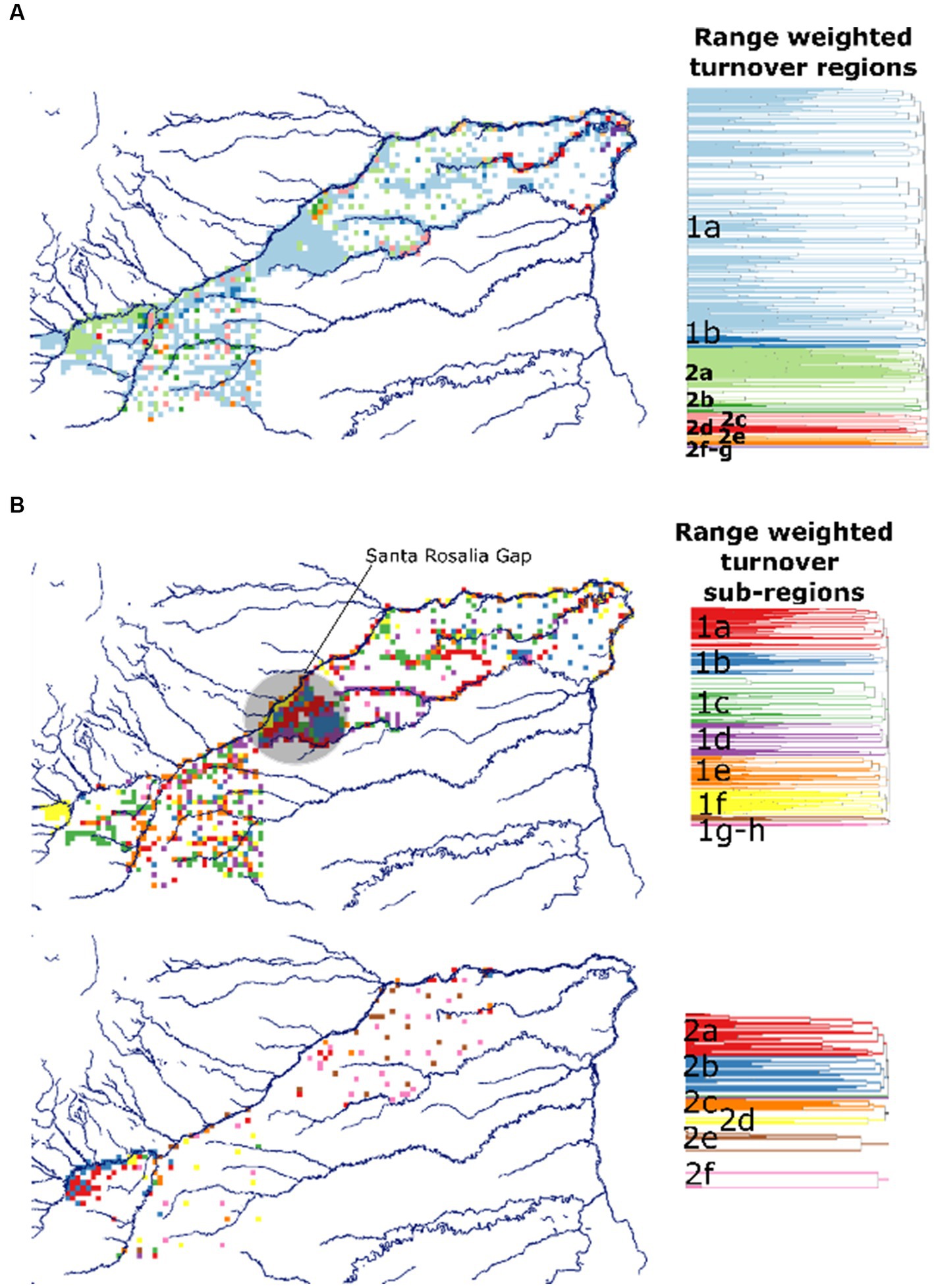
Figure 4. Biogeographic regions of fauna in OHP based on range-weighted turnover: (A) major regions; (B) sub-regions. Dendrograms of geographic distance showing clusters of endemic regions. White areas have no data available.
We propose the Santa Rosalía Gap as a strategic biodiversity region of the OHP (Figure 4B). To the northwest, it borders on the Meta River banks between the confluence of the Cusiana and Carare rivers, and to the southeast, on the lower ends of the Tomo and Elvita rivers. The Santa Rosalía Gap is a vital corridor between the eastern Orinoco savannas and the western Andean transitional savannas because it contains biodiversity elements from both ecoregions while acting as a hotspot of SR. Because of its strategic location, the Santa Rosalía Gap is a region of geographic overlap for multiple biodiversity elements that are dissimilar from each other and, at the same time, geographically restricted, likely due to the unique structure of the micro catchments comprising the Santa Rosalía region.
Linking agriculture and biodiversity
The V-metric shows that Puerto Carreño has the lowest spatial association between the agricultural frontier and the PES (Figure 5). Santa Rosalia shows the highest values of spatial association, whereas La Primavera has an intermediate value. Hotspots of fauna SR overlapped with areas of high spatial association in the Santa Rosalía’s Gap. CWE hotspots, on the other hand, overlap with areas of low to intermediate association in Puerto Carreño. Santa Rosalía shows high spatial association between agriculture and biodiversity likely due to be a highly developed region with complex hydrological networks that promote fauna SR. Areas of low association in Puerto Carreño and La Primavera are potential candidates for future sustainable agriculture and biodiversity expansion because they are exposed to less degree of human development, whereas Santa Rosalía is under greater threat than other regions.
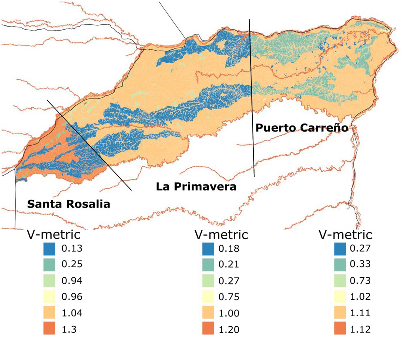
Figure 5. Map of the spatial changes and associations between the Agricultural Frontier [Unidad de Planificación Rural Agropecuaria (UPRA), 2021] and the Principal Ecological Structure [Deutsche Gesellschaft für Internationale Zusammenarbeit GmbH (GIZ), 2020a] for Santa Rosalía, La Primavera and Puerto Carreño in the Orinoco high plains of Colombia.
Discussion
Our results present new evidence that could be considered an early warning that hotspots of biodiversity in the OHP are under pressure due to agricultural expansion (Figure 5). A new action plan to map out the less vulnerable areas and more suitable lands for safe and sustainable future agrarian development in Puerto López, Puerto Gaitán, Santa Rosalía, La Primavera and Puerto Carreño will be required to address this challenge.
We suggest that each municipality plan its sustainability policy and agricultural development accordingly. The Santa Rosalía region, for example, has the highest exposure V-index, offering a high ecosystem risk (Figure 5). In a relatively small area, Santa Rosalía has more water resources, which suggests a great advantage for wildlife to thrive. Biologically, it is the main centre of fauna species richness with a high density of endemic bioregions. We tentatively argue that Santa Rosalía is a priority site which will require a careful treat under the future growth of agricultural development. Considering many of these factors, it will require a more hands-on sustainability plan to reduce the impacts of unplanned agriculture. Being the smallest of the five municipalities in the OHP provides a managerial advantage, so this region should become an exemplary case of friendly and effective agrobiodiversity development. Other external pressures, such as its proximity to Puerto Gaitán by road and fluvial connectivity with other agro-hubs, suggest this area should be prioritised for further intervention by the national government and local actors.
On the other hand, Puerto López and Puerto Gaitán are more developed in agricultural growth than other regions in the OHP of Colombia. Although the V-index was not calculated for these two municipalities, we assume the exposure value could be even higher than the one in Santa Rosalía. Some rules should be established to develop a friendly agricultural expansion towards the east of the OHP using lessons learned from these two large municipalities. In this region, the government should establish a land care centre where a multisector partnership units and proposes actions that mitigate adverse impacts on the ecosystem’s health. In terms of biodiversity, the confluence of the upper Meta River and other tributaries such as Guatiquía, Yucao and Manacacías in Puerto López and the western boundaries of Puerto Gaitán makes this region vital for the conservation of unique elements of biodiversity. For instance, these regions have many secondary centres of endemism for fauna and flora (Figures 4B,D) that should be protected to reduce the risk of losing range-restricted species. Regional planning programmes in Puerto López and Puerto Gaitán municipalities should focus on landscape recovery and agronomical remediation; for example, implementing conservation zones based on soil carbon information (Hyman et al., 2022).
As expected, our V-index proved that a lower degree of spatial changes and association is found further east in the OHP suggesting a lower risk of environmental degradation. However, the spatial patterns of biodiversity highlight that La Primavera and Puerto Carreño were of high biological importance in terms of endemism associated with river ecosystems and outcrops. Remoteness and lack of road access in these municipalities maintain biodiversity less exposed to human impacts. These regions should be highly protected, and agricultural development should be even more carefully planned than any other region in the OHP. A solid effort to implement systems designed under a conservation agriculture and biodiversity vision is fundamental in these two agricultural frontiers.
Agrosavias’ tools to help small farmers in the Orinoco eastern high plains
Some possible strategies to mitigate impacts on biodiversity and generate more sustainable development in agriculture for the OHP are summarised in the 12 technological offers (OTs; Table 1). The OTs were developed under a research scheme of the Corporación Colombiana de Investigación Agropecuaria (Agrosavia). OT’s technical packages have been designed for farmers (available).3 For instance, the case of Carimagua’s field station.
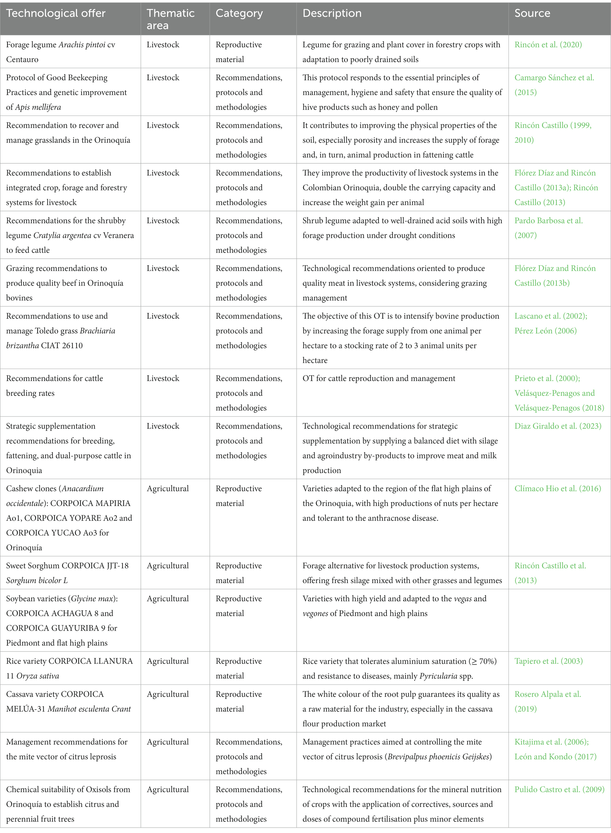
Table 1. Technological packages of agriculture or OTs for the OHP region in Colombia.
Within these OTs, there are several management recommendations that farmers could apply to different work areas and varieties, such as grasses and legumes that adapt to the climate and soil conditions of the OHP region (Examples 1 and 2 below). Example 1 is related to the management of pastures based on good practices of sustainable systems, which could be applied across the most impacted areas in the OHP to reduce exposure to landscape degradation.
1. This OT was designed to establish the integrated crop, forage and forestry systems for livestock. It provides recommendations to improve the productivity of livestock systems on farms in the Colombian Orinoquía region. Its application has the potential to double the carrying capacity and increase the weight gain per animal from 300 to 700 grams/animal per day, which could reflect an increase of 120 to 550 kg of meat/ha per year. The silage of transient crops such as soybeans and corn is a viable solution for feeding cattle in critical times of drought, and the establishment of trees in livestock systems contributes to animal welfare and the system’s biodiversity.
Example 2 is an ecologically important strategy that could be implemented in degraded pastures. This aspect will provide more resilience to the agricultural livestock systems that, for years, have been mismanaged. For instance, the proposed legume species could be planted in small areas under a rotational system for more sustainable cattle grazing.
2. The Arachis pintoi (cv. Centauro) OT is based on a legume species. It is used for forage that typically feeds cattle. Centauro peanuts adapt well to acid, poorly drained and low-fertility soils. It can improve the nutritional quality of pastures associated with native grasses used for cattle feeding. On the other hand, the large amount of crude protein content is a feature that helps the nutrition of livestock, mainly where milk production in dual-purpose cows grazing cv. Centauro + Urochloa humidicola occurs (before Brachiaria humidicola). This practice could increase productivity by 95% (Rincón Castillo, 2013; Rincón et al., 2020; Díaz-Giraldo et al., 2021; Rincón Castillo et al., 2022).
Lessons learned
A science-based strategy for the regional planning of biodiversity and agriculture is crucial for decision-making and land-use planning. Combining information from different sources (UPRA, SIB Col, EPP) adds value to the current knowledge of the high plains’ exposure to degradation, avoiding negative impacts, for example, through hotspot transformation and biodiversity loss. Mitigation of these impacts is possible by informing decision-makers and other key stakeholders about the hotspots of biodiversity and exposure to agriculture transformation. This information can be vital to implementing sustainable land-use planning and biodiversity conservation and choosing suitable OT for developing the territory.
Successful land-use planning and biodiversity conservation also requires other enabling conditions, including skilled people, building collective capacity, political will and information that local communities can use. The shortage of available information can be improved by using the map data viewer to make the results more accessible. However, work must be done to improve the enabling conditions for future OH management.
To contribute to better land planning of Meta and Vichada, we recognised the importance of zooming in on the critical areas and exploring in the future the Cumaribo region, which is a crucial area of Vichada. In addition, understanding the learned lessons such as previous studies developed in the Carimagua fieldstation could be another way to improve the OHP management.
Carimagua is one of Agrosavia’s research stations. It is the most isolated and covers an approximate area of 22.000 hectares in the heart of Meta. Some of the OTs listed in Table 1 are closely related to the development of new species of tropical pastures adapted to the regional conditions of the eastern plains (Álvarez and Rincón, 2010; Rincón Castillo et al., 2022). These technological advances are materialised in the scientific achievements conducted in Carimagua. Since the 1970s, researchers developed a new species of grasses (i.e. scientific name) that revolutionised pasture adaptation and cattle production systems in South America. Carimagua offers the ideal conditions for scientists and regional communities to test new ideas and applied research that can help to conserve the native ecosystems of the plains. We encourage the community to visit the fascinating empirical research achievements of Carimagua and create liaisons with Agrosavia’s community through Carimagua’s facilities.
Limitations
While the early warning approach is valuable in helping national and local stakeholders to develop a more sustainable vision for regional planning, there is an increasing realisation that barriers to effective communication with stakeholders are still common. To reduce such gaps, a map data viewer tool is a potential solution to engage the community with science-based solutions.
The OHP region is biologically poorly understood and sparsely documented. Therefore, data deficiencies regarding spatial coverage of species occurrences are an inevitable bias in this vast region. Small sample sizes over relatively large areas can cause spatial patterns of biodiversity to be distorted. We acknowledge this issue, but at the same we provided and used the best data available at least for some key groups of fauna and flora. Under the current circumstances, to reach a complete sample of species diversity in the whole OHP is unrealistic. Species distribution modelling could be applied to fill up the sampling gaps. For instance, the biodiversity programme in the Humboldt institute has indeed modelled the distribution of many species in the OHP region showing the potential application of such approaches in under sampled regions. Our results of spatial patterns of biodiversity should be interpreted with care and used as indicators rather than definitive answers.
Regarding the V-metric, we acknowledge that the spatial changes and its associations just represent a snapshot in time over the history of the OHP. Hence, they should not be interpreted as a unique trend. Despite this limitation, our results provided new information about impacts of human on the agrobiodiversity of the eastern high plains of Colombia also known as ¨Altillanura¨ and considered one of the future agricultural frontiers in the region.
Conclusion
A better scientific understanding of the effects of agricultural expansion on biodiversity is needed to shape policy and improve environmental management along this future agricultural frontier.
Data availability statement
The distributional data for fauna and plants presented in the study are included in the article/supplementary material, further inquiries can be directed to the corresponding author.
Author contributions
All authors contributed to the study conception and design. Material preparation was performed by RD-G. Data analysis was performed by CG-O. Data collection of the fauna and flora species distribution was performed by GIZ under the supervision of CR-C. The first draft of the manuscript was written by CG-O and all authors commented on previous versions of the manuscript. All authors contributed to the article and approved the submitted version.
Acknowledgments
The authors thank the Corporación Colombiana de Investigación Agropecuaria (Agrosavia) for providing funding. This article is part of the collaboration between GIZ and Agrosavia CI La Libertad. In addition, this article and the research behind it would not be possible without the information provided by the Tonina GIZ project, financed by the Federal Ministry for the Environment, Nature Conservation, Nuclear Safety and Consumer Protection. The Tonina GIZ project aimed to integrate the importance of nature’s benefits in the regional and agricultural development of the Colombian Orinoquía. This paper had some external consultancies for its preparation. We want to thank Román Tibavija and Paola Fernandez for their constructive comments on an earlier version of the article.
Conflict of interest
CR-C was employed by the company Deutsche Gesellschaft für Internationale Zusammenarbeit (GIZ), GmbH.
The remaining authors declare that the research was conducted in the absence of any commercial or financial relationships that could be construed as a potential conflict of interest.
Publisher’s note
All claims expressed in this article are solely those of the authors and do not necessarily represent those of their affiliated organizations, or those of the publisher, the editors and the reviewers. Any product that may be evaluated in this article, or claim that may be made by its manufacturer, is not guaranteed or endorsed by the publisher.
Supplementary material
The Supplementary material for this article can be found online at: https://www.frontiersin.org/articles/10.3389/fsufs.2023.1192054/full#supplementary-material
Footnotes
References
Álvarez, M., and Rincón, A. (2010). “Características agroecológicas de la Orinoquía colombiana” in Establecimiento, manejo y utilización de recursos forrajeros en sistemas ganaderos de suelos ácidos. eds. A. Rincón and C. A. Jaramillo (Colombia: Corporación Colombiana de Investigación Agropecuaria – Corpoica), 27–70.
Andrade, G., Romero, M., and Delgado, J. (2013). Diseño adaptativo de un paisaje agroindustrial. Una propuesta para la transformación agrícola de la altillanura colombiana. Ambiente y Desarrollo 17, 29–40.
Baptiste, B., Pinedo-Vasquez, M., Gutierrez-Velez, V. H., Andrade, G. I., Vieira, P., Estupiñán-Suárez, L. M., et al. (2017). Greening peace in Colombia. Nat Ecol Evol 1:0102. doi: 10.1038/s41559-017-0102
Bustamante, C. (2019). “Gran Libro de la Orinoquía colombiana” in Instituto de Investigación de Recursos Biológicos Alexander von Humboldt - Deutsche Gesellschaft für Internationale Zusammenarbeit (GIZ) (Colombia: GmbH).
Camargo Sánchez, E. R., Ortega Flórez, N. C., Maldonado Quintero, W. D., and Vásquez Romero, R. E. (2015). Implementación de buenas prácticas apícolas y mejoramiento genético para la producción de miel y polen. Corporación colombiana de investigación agropecuaria – AGROSAVIA. Available at: http://hdl.handle.net/20.500.12324/13301
Clímaco Hio, J., Guevara Agudelo, E. J., Navas Arboleda, A. A., and Arango Wiesner, L. V. (2016). Corpoica Mapiria Ao1, Corpoica Yopare Ao2, Corpoica Yucao Ao3: clones de marañón para la altillanura plana de la Orinoquía colombiana. Corporación colombiana de investigación agropecuaria – AGROSAVIA. Available at: http://hdl.handle.net/20.500.12324/11535
Convention on Biological Diversity (CBD). (2022). Colombia: biodiversity facts, status, and trends of biodiversity, including benefits and ecosystem services. Available at: https://www.cbd.int/countries/profile/?country=co#:~:text=Biodiversity%20Facts&text=Colombia%20is%20listed%20as%20one,butterflies%2C%20freshwater%20fishes%20and%20amphibians
Correa, H. D., Ruiz, S. L., and Arévalo, L. M. (2006). Plan de acción en biodiversidad de la cuenca del Orinoco – Colombia−/ 2005 - 2015 – Propuesta Técnica. Corporinoquia, Cormacarena, IAvH, Unitrópico, Fundación Omacha, Fundación Horizonte Verde, Universidad Javeriana, Unillanos, WWF – Colombia, GTZ, Colombia.
Crisp, M. D., Laffan, S., Linder, H. P., and Munro, A. (2001). Endemism in the Australian Flora. J. Biogeogr. 28, 183–198. doi: 10.1046/j.1365-2699.2001.00524.x
Deutsche Gesellschaft für Internationale Zusammenarbeit GmbH (GIZ). (2020a). Altillanura: su historia ambiental, gobernanza y gobernabilidad en el uso y manejo de la biodiversidad y los beneficios de la naturaleza. Proyecto Transformando la Orinoquia con la Integración de los beneficios de la Naturaleza en Agendas sostenibles (Tonina). Available at: https://www.giz.de/en/downloads/2020-09-08-Altillanura_Tonina.pdf
Deutsche Gesellschaft für Internationale Zusammenarbeit GmbH (GIZ) (2020b). Elaboración de la Estructura Ecológica Principal a escala 1:25:000 y sus insumos en los municipios de Puerto Carreño, La Primavera y Santa Rosalía, en el Departamento de Vichada. Proyecto Transformando la OriNoquia con la Integración de los beneficios de la Naturaleza en Agendas sostenibles (Tonina).
Díaz-Giraldo, R. A., Álvarez, M., and Pérez, O. (2021). Uso de sensores remotos en la determinación del forraje disponible de Urochloa humidicola cv. Llanero bajo pastoreo en la Altillanura colombiana. Tropical Grasslands 9, 376–382. doi: 10.17138/tgft(9)376-382
Diaz Giraldo, R. A., De Leon, M. A., Castillo, A. R., Lopez, O. P., Rocha, E. C., Asprilla, W. P., et al. (2023). Estimation of forage availability and parameters associated with the nutritional quality of Urochloa humidicola cv Llanero based on multispectral images. Trop. Grassl.-Forrajes Trop. 11, 61–74. doi: 10.17138/TGFT(11)61-74
Etter, A., Andrade, A., Nelson, C. R., Cortés, J., and Saavedra, K. (2020). Assessing restoration priorities for high-risk ecosystems: an application of the IUCN red list of ecosystems. Land Use Policy 99:104874. doi: 10.1016/j.landusepol.2020.104874
Flórez Díaz, H., and Rincón Castillo, Á. (2013a). Uso de cultivos como estrategia de alimentación de bovinos durante la época seca. Corporación colombiana de investigación agropecuaria – AGROSAVIA. Available at: http://hdl.handle.net/20.500.12324/19687
Flórez Díaz, H, and Rincón Castillo, Á. (2013b). Sistemas integrados: agrícola - ganadero - forestal, para el desarrollo de la Orinoquia colombiana. Corporación colombiana de investigación agropecuaria – AGROSAVIA. Available at: http://hdl.handle.net/20.500.12324/13567
Garcillán, P. P., Ezcurra, E., and Riemann, H. (2003). Distribution and species richness of Woody dryland legumes in Baja California, Mexico. J. Veg. Sci. 14, 475–486. doi: 10.1111/j.1654-1103.2003.tb02174.x
González-Orozco, C. E. (2021). Biogeographical regionalisation of Colombia: a revised area taxonomy. Phytotaxa 484, 247–260. doi: 10.11646/phytotaxa.484.3.1
Hyman, G., Castro, A., Da Silva, M., Arango, M., Bernal, J., Pérez, O., et al. (2022). Soil carbon storage potential of acid soils of Colombia’s eastern High Plains. Front. Sustain. Food Systems 6:954017. doi: 10.3389/fsufs.2022.954017
Instituto Alexander von Humboldt. (2016). Mapa de humedales de Colombia. Editorial Instituto de Investigación de Recursos Biológicos Alexander von Humboldt. Available at: http://repository.humboldt.org.co/handle/20.500.11761/9575.
Instituto Alexander von Humboldt. (2019). Informe Julio 2019. Acuerdo de Subvención 19-068_ Transformando la Orinoquía con la Integración de los beneficios de la Naturaleza en Agendas sostenibles (TONINA). Colombia: TEEB Orinoquia.
Instituto de Hidrología, Meteorología y Estudios Ambientales (IDEAM). (2013). Zonificación y Codificación de Cuencas Hidrográficas.
Instituto Geográfico Agustín Codazzi (IGAC). (1997). Regiones naturales de Colombia. Available at: http://www2.igac. iñosco/ninos/UserFiles/Image/Mapas/regiones%20naturales.pdf
Instituto Geográfico Agustín Codazzi (IGAC). (1999). Paisajes fisiográficos de Orinoquia-Amazonia (ORAM) Colombia. Colombia: Análisis Geográficos.
Kitajima, E. W., Freitas, J., and León, G. A. (2006). Diagnóstico y recomendaciones de manejo para la leprosis de los cítricos. Corporación colombiana de investigación agropecuaria – AGROSAVIA. Available at: http://hdl.handle.net/20.500.12324/2022
Laffan, S. W., Lubarsky, E., and Rosauer, D. F. (2010). Biodiverse, a tool for the spatial analysis of biological and related diversity. Ecography 33, 643–647. doi: 10.1111/j.1600-0587.2010.06237.x
Laffan, S. W., Rosauer, D. F., di Virgilio, G., Miller, J. T., González-Orozco, C. E., Knerr, N., et al. (2016). Range-weighted metrics of species and phylogenetic turnover can better resolve biogeographic breaks and boundaries. Methods Ecol. Evol. 7, 580–588. doi: 10.1111/2041-210X.12513
Lascano, C., Perez, R., Plazas, C., Medrano, J., Perez, O., and Argel, P. (2002). Pasto Toledo (Brachiaria brizantha CIAT 2610): gramínea de crecimiento vigoroso para intensificar la ganadería colombiana. Corporación colombiana de investigación agropecuaria – AGROSAVIA. Available at: http://hdl.handle.net/20.500.12324/36716
Lavelle, P., Rodríguez, N., Arguello, O., Bernal, J., Botero, C., Chaparro, P., et al. (2014). Soil ecosystem services and land use in the rapidly changing Orinoco River basin of Colombia. Agric. Ecosyst. Environ. 185, 106–117. doi: 10.1016/j.agee.2013.12.020
León, G., and Kondo, T. (2017). Insectos y ácaros de los cítricos: compendio ilustrado de especies dañinas y benéficas, con técnicas para el manejo integrado de plagas. Corporación colombiana de investigación agropecuaria – AGROSAVIA. Available at: http://hdl.handle.net/20.500.12324/13148
Maitner, B. S., Boyle, B., Casler, N., Condit, R., Donoghue, J. II, Durán, S. M., et al. (2018). The bien r package: a tool to access the botanical information and ecology network (BIEN) database. Methods Ecol. Evol. 9, 373–379. doi: 10.1111/2041-210X.12861
Morrone, J. J. (2014). Biogeographical regionalisation of the Neotropical region. Zootaxa 3782, 1–110. doi: 10.11646/zootaxa.3782.1.1
Nowosad, J., and Stepinski, T. F. (2018). Spatial association between regionalisations using the information-theoretical V-measure. Int. J. Geogr. Inf. Sci. 32, 2386–2401. doi: 10.1080/13658816.2018.1511794
Pardo Barbosa, O., Parra Arango, J. L., Cerinza, O. J., Pinzón, S. M., Correal, W. A., Rojas Barreto, A., et al. (2007). Establecimiento, manejo y uso de la leguminosa arbustiva forrajera Cratylia argentea cv Veranera en el Piedemonte Llanero. Corporación colombiana de investigación agropecuaria – AGROSAVIA. Available at: http://hdl.handle.net/20.500.12324/13318
Pérez León, O. (2006). Gramíneas forrajeras con potencial para sistemas de producción de ganadería bovina. Corporación colombiana de investigación agropecuaria – AGROSAVIA. Available at: http://hdl.handle.net/20.500.12324/17524
Prieto, M E., Espítia, P A., Alvarado, A L., and Cardozo, C J. (2000). El manejo estratégico del amamantamiento mejora el porcentaje de preñez en sistemas de producción bovina de doble propósito y cría libre. Corporación colombiana de investigación agropecuaria – AGROSAVIA. Available at: http://hdl.handle.net/20.500.12324/746
Pulido Castro, S. X., Alvarado Pérez, B., Polanco Artunduaga, N., Almansa Manrique, E. F., Gutiérrez Vanega, A. J., Salamanca Solis, C. R., et al. (2009). Evaluación de la citricultura del departamento del Casanare y recomendaciones para su mejoramiento productivo. Corporación colombiana de investigación agropecuaria – AGROSAVIA. Available at: http://hdl.handle.net/20.500.12324/12769
Rincón, Á., Bueno, G., Díaz, R., Burkart, S., and Enciso, K. (2020). Cultivar Centauro (Arachis pintoi 22160) Leguminosa forrajera para sistemas de ganadería sostenible. Corporación Colombiana de Investigación Agropecuaria (Agrosavia). Editorial Agrosavia. doi: 10.21930/agrosavia.brochure.7403909
Rincón Castillo, Á. (1999). Degradación y recuperación de praderas en los Llanos Orientales de Colombia. Corporación colombiana de investigación agropecuaria – AGROSAVIA. Available at: http://hdl.handle.net/20.500.12324/16350
Rincón Castillo, Á. (2010). Degradación de praderas y estrategias para su recuperación. Corporación colombiana de investigación agropecuaria – AGROSAVIA. Available at: http://hdl.handle.net/20.500.12324/1712
Rincón Castillo, Á. (2013). Sistemas integrados agrosilvopastoriles y sus efectos en las propiedades químicas y físicas de los suelos. Corporación colombiana de investigación agropecuaria – AGROSAVIA. Available at: http://hdl.handle.net/20.500.12324/19688
Rincón Castillo, Á., and Guevara, A. E. J., Hernández, S R. S., Mejía Kerguelén, S., and Bernal, R J H. (2013). Sorgo forrajero Corpoica JJT-18. Corporación Colombiana de Investigación Agropecuaria (Agrosavia). Available at: http://hdl.handle.net/20.500.12324/11539
Rincón Castillo, Á., Peters, M., Pérez López, O., Pardo Barbosa, O., Cerinza Murcia, Ó. J., Villalobos Bermúdez, M. A., et al. (2022). Pasto Agrosavia Caporal (Urochloa brizantha CIAT 26124): Gramínea forrajera de buena calidad nutritiva para los sistemas ganaderos de la Orinoquia Colombiana. Corporación Colombiana de Investigación Agropecuaria (Agrosavia). doi: 10.21930/agrosavia.nbook.7405187
Rosero Alpala, E. A., Ceballos, H., Calle, F., Salazar, S., Morante, N., Beltrán, F., et al. (2019). Agrosavia Melúa-31 Nueva variedad de yuca industrial para la Orinoquía colombiana. Corporación Colombiana de Investigación Agropecuaria (Agrosavia). doi: 10.21930/agrosavia.brochure.7403022
Rosselli, L., Rodriguez-Castañeda, C., Soto-Vargas, C., Diaz-Pulido, A., Campo-Soto, P., Moreno-Botero, C., et al. (2022). Sistema de monitoreo basado en una red de colaboración: Biodiversidad del Triángulo del Puma. Bogota: Deutsche Gesellschaft für Internationale Zusammenarbeit (GIZ) GmbH, Proyecto Transformando la OriNoquia con la Integración de los beneficios de la Naturaleza en Agendas sostenibles (Tonina).
Tapiero, O A. L., Caicedo, G S., Baquero, P. J. E., Ospina, Y., Guimaraes, E., and Chatel, M. (2003). Arroz Corpoica Llanura 11: variedad mejorada de alta precocidad para los sistemas productivos de la altillanura plana. Corporación Colombiana de Investigación Agropecuaria (Agrosavia). Available at: http://hdl.handle.net/20.500.12324/11506
Unidad de Planificación Rural Agropecuaria (UPRA). (2021). Identificación general de la frontera agrícola en Colombia, a escala 1: 100.000. Abril 2018 (Original source).
Vargas, C. A., Bottin, M., Sarkinen, T., Richardson, J. E., Raz, L., Garzon-Lopez, C. X., et al. (2022). Environmental and geographical biases in plant specimen data from the Colombian Andes. Bot. J. Linn. Soc. 200, 451–464. doi: 10.1093/botlinnean/boac035
Velásquez-Penagos, J., and Velásquez-Penagos, J. (2018). Suspensión transitoria de lactación a la cría en la producción y fertilidad del Cebú puro en condiciones del piedemonte llanero en Colombia. Ciencias Veterinarias 36:27. doi: 10.15359/rcv.36-3.23
Keywords: Altillanura, conservation, endemism, Orinoquía, richness, sustainable management
Citation: González-Orozco CE, Diaz-Giraldo RA and Rodriguez-Castañeda C (2023) An early warning for better planning of agricultural expansion and biodiversity conservation in the Orinoco high plains of Colombia. Front. Sustain. Food Syst. 7:1192054. doi: 10.3389/fsufs.2023.1192054
Edited by:
Diego Griffon, Central University of Venezuela, VenezuelaReviewed by:
Matthew C. LaFevor, University of Alabama, United StatesFrancisco Velasco, Central University of Venezuela, Venezuela
Copyright © 2023 González-Orozco, Diaz-Giraldo and Rodriguez-Castañeda. This is an open-access article distributed under the terms of the Creative Commons Attribution License (CC BY). The use, distribution or reproduction in other forums is permitted, provided the original author(s) and the copyright owner(s) are credited and that the original publication in this journal is cited, in accordance with accepted academic practice. No use, distribution or reproduction is permitted which does not comply with these terms.
*Correspondence: Carlos E. González-Orozco, Y2Vnb256YWxlekBhZ3Jvc2F2aWEuY28=