- 1International Crops Research Institute for the Semi-Arid Tropics, Dar es Salaam, Tanzania
- 2International Crops Research Institute for the Semi-Arid Tropics, Bamako, Mali
- 3Department of Geography, Faculty of History and the Geography, University of Social Sciences and Management of Bamako, Bamako, Mali
- 4GIS and Remote Sensing Laboratory, Institut d'Economie Rurale, Bamako, Mali
- 5International Water Management Institute, Accra, Ghana
- 6International Institute of Tropical Agriculture, Accra, Ghana
Introduction: In rainfed agricultural systems, sustainable and efficient water management practices are key to improved agricultural productivity and natural resource management. The agricultural system in sub-Saharan Africa (SSA) relies heavily on the availability of rainfall. With the erratic and unreliable rainfall pattern associated with poor and fragile soils, agricultural productivity has remained very low over the years. Much of the SSA agricultural land has been degraded with low fertility as a result of ongoing cultivation and wind and water erosion. This has resulted in an increased food shortage due to the ever-increasing population and land degradation. Better agricultural and nutritional security are further hampered by the lack of reliable access to the available water resources in the subsurface hydrological system.
Methods: This study used socio-economic data from 112 farm households and Boolean and Fuzzy methods to understand farmers' perceptions and identify suitable areas to implement Solar Based Irrigation Systems (SBISs) in the agro-ecologies of Bougouni and Koutiala districts of southern Mali.
Results and discussion: Results revealed that the usage of SBISs has been recent (4.5 years), majorly (77%) constructed by donor-funded projects mainly for domestic water use and livestock (88%). With regards to irrigation, vegetable production was the dominant water use (60%) enabling rural farm households to gain over 40% of extra household income during the dry season. Results further showed that 4,274 km2 (22%) of the total land area for the Bougouni district, and 1,722 km2 (18%) of the Koutiala district are suitable for solar-based irrigation. The affordability of solar panels in many places makes SBISs to be an emerging climate-smart technology for most rural Malian populations.
1. Introduction
In many sub-Saharan African (SSA) countries, much of the agricultural development is constrained by the gap in knowledge on improved agricultural practices (Attia et al., 2022). This has resulted in few options for smallholder rural farm households to improve their livelihoods. The problem is aggravated by the increased frequency of rainfall variability and depleted soil nutrients from many of the farm fields. As a result, crop and livestock productivity has remained low for many years in most SSA countries (Birhanu et al., 2019). Much of the agricultural land in Mali has been degraded and is less fertile because of rigorous cultivation over the years along with wind and water erosion. This has resulted in increased food shortages as the land has not been able to support the food demands of the ever-increasing population. Better agricultural and nutritional security options are further hampered by the lack of reliable access to available water resources in the subsurface hydrological system. Sustainable and efficient water management practices are key to improved smallholders' agricultural productivity and natural resource management in rainfed agricultural systems.
Farmers in rural Mali cultivate vegetable gardens during the dry season using traditional irrigation systems. The vegetable gardens, though limited in scope, allow diversification of food in the household, leading to an increased household income. Traditional irrigation is practiced using shallow wells that have depths ranging from 6.5 to 14.5 meters (Birhanu and Tabo, 2016). A recently conducted survey on water availability and access in rural Mali revealed that while 39% of rural Malians always lack water, periodic water shortages are experienced by the majority of communities (61%) (Sanogo et al., 2021) sometimes or the other. In the traditional system, water for irrigation is collected manually from shallow wells through a bucket connected to a rope.
In recent years, several attempts are being undertaken in rural areas of developing countries (for example in Ethiopia, Senegal, and Ivory Coast) for the installation of electric pumps fed by solar energy and modern irrigation systems to promote renewable energy and water use efficiency in agriculture (Noubondieu et al., 2018). In Mali, despite developing institutional and programmatic commitments in 2011 (Attia et al., 2022), the government's ambitious plan to advance its irrigation capacity in the past decade was hampered by the worsening socio-economic and political crises. Additionally, there exists a huge potential investment gap in the Malian agricultural sector (Partey et al., 2018).
While it was commonly understood that SBISs are considered emerging climate-smart technologies (Noubondieu et al., 2018; Schmitter et al., 2018; Mugisha et al., 2021), little is known about their potential role in improving agricultural productivity for smallholders in Mali. In some parts of the country, farmers were better organized and were able to get support from different donor-funded projects. For example, the Feed the Future Innovation Lab for Small-Scale Irrigation (ILSSI), the CGIAR Research Program on Water, Land and Ecosystems (WLE), and the Africa Research In Sustainable Intensification for the Next Generation (Africa RISING) benefitted farmers for domestic water supply and small-scale irrigation practices (IITA and ILRI, 2018; Gadeberg, 2020). In their study of georeferencing 484 shallow wells in southern Mali, Birhanu and Tabo (2016) highlighted that the issue of water scarcity in most rural Mali was attributed to accessibility due to the lack of appropriate water-lifting mechanisms. Other studies (DNH, 2016) also confirmed that extraction and use of groundwater resources for irrigation have been very low in most places of rural Mali.
Of solar-based irrigation is promising for cost-effective and transformative technology to expand smallholder agriculture production, increase household water security, and offer solutions for climate-smart agricultural development (Brunet et al., 2018; Lefore et al., 2021; Xie et al., 2021). However, the expansion of solar-based irrigation is currently a hurdle for appropriate adoption due to the lack of integrated and adaptive approaches to address the contextual specification with diverse technologies, and actors across the public and private sectors (Ockwell et al., 2018; Minh et al., 2020; Izzi et al., 2021). Expanding SBISs, particularly in rural community settings require smallholder farmers' commitment and their increased awareness of the potential benefit of the investment. Similarly, a technical understanding of the environmental variables using available spatial and temporal data is important to establish criterion and restriction factors in identifying suitable sites to implement SBISs.
Recent studies employed a multiple-criteria-decision-making method and determined features such as accessibility to water sources, soil, slope, and land use and land cover (LULC) as important factors for surface irrigation site-suitability selection (e.g., Girma et al., 2020; Hagos et al., 2022). Similar spatial thematic layers and additional high-resolution datasets were collected and used in a mathematical algorithm in a GIS environment to facilitate the identification and selection of potential sites for SBISs in rural Mali (e.g., Kamaraju et al., 1996; Murthy, 2000; IWMI, 2019). Additionally, population density and data on urban and rural settlements were integrated into the machine learning algorithm to determine site suitability at the district level. A well-defined restriction factor was set for each data set using the Boolean model (Noorollahi et al., 2016) to aggregate the multiple factors and determine and select alternatives. Therefore, this study aimed to (i) understand farmers' perceptions and awareness of utilizing SBISs on the existing agricultural productivity and socio-economic benefits; and (ii) use a multiple-criteria-decision-making tool in a GIS environment to identify and map suitable areas for the potential investment of SBISs.
2. Materials and methods
2.1. Study area
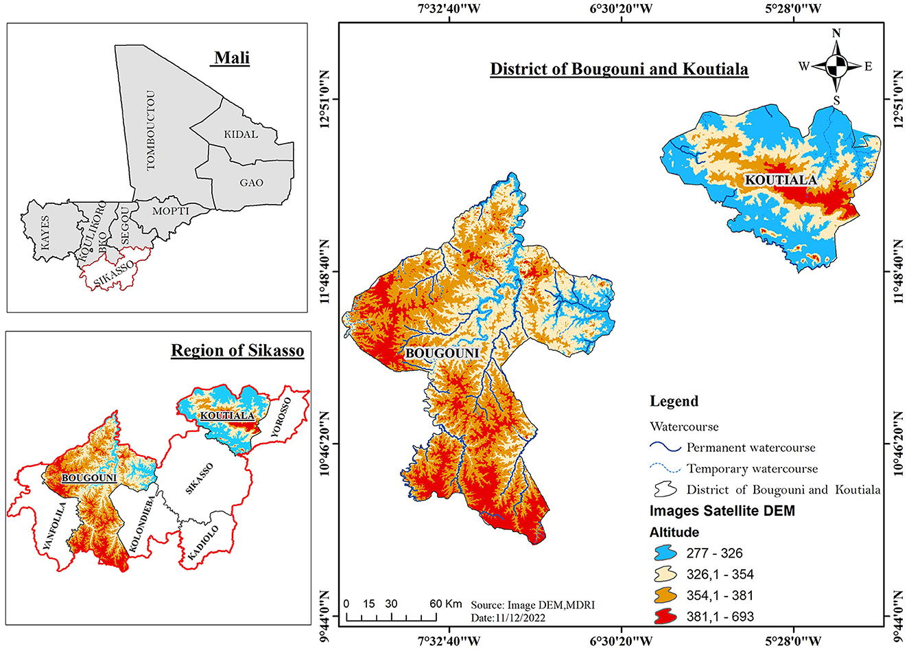
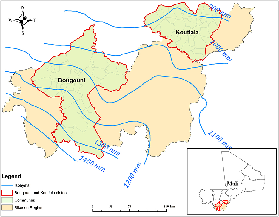
The study was carried out in the Bougouni and Koutiala districts which comprise 41% of Sikasso's region in southern Mali (Figure 1). With a total land mass of 70, 280 km2, rainfall in the region varies from 800 to 1,200 mm (Birhanu et al., 2022). Sikasso region, with a Sudanian savanna ecosystem (Cooper and West, 2017) inhabits a total population of 2.63 million (Institut National de la Statistique, 2009). The five other districts in the region include Kadiola, Kolendieba, Sikasso, Yanfolila, and Yorosso. The vegetation in the area is composed of wooded and shrub savannah which are well-preserved in the south but are severely degraded in the center and the north of the districts. All the alluvial plains are covered with a grassy savannah and gallery forest along the rivers. The soils in the region are characterized as having high erosion risk, low water storage capacity, and poor drainage conditions. The agricultural economy in the region is characterized by rainfed, small-scale crops, livestock, and integrated crop-livestock/agro-pastoral farming systems (IITA, 2016). The months of June to September contribute 80% of the total annual rainfall. The long-term (1970–2018) mean annual rainfall of the Bougouni district is 1,060 mm, and that of Koutiala is 862 mm. The long-term (1970–2018) average monthly maximum and minimum air temperatures in the two districts are 33 and 22°C in Bougouni and 34 and 23°C in Koutiala, respectively (Birhanu et al., 2022).
2.2. Data and data source
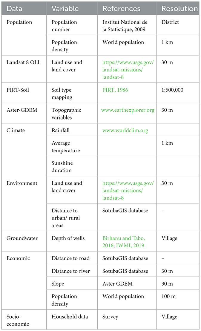
Data for the study was collected from multiple sources (Table 1). Population data was sourced from the national census record. In this case, two population datasets were used. The first dataset was derived from the national demographic database of 2009 (Institut National de la Statistique, 2009). This dataset was used to estimate the population in 2019 INSTAT (2011). The second data was sourced from the World Population database available at 1 km resolution (Table 1). Spatial data on land use land cover and topographic variables were obtained at 30 m resolution from satellite-derived information using GIS and Remote Sensing tools. The soil map (1:500,000) of Mali was derived from the national Terrestrial Land Resources Inventories known as “Project Inventaire des Resources Terrestre: PIRT” of 1984. The world climatological database was used to derive the climate information required for the study. Environmental factors (land use and land cover, distance to urban/ rural areas) and economic factors (distance to the road, slope, distance to river, population density) were sourced from the Malian national GIS database available at the Institute of Rulale Economy (IER). Groundwater level data was sourced from previously georeferenced databases of Birhanu and Tabo (2016) and the spatial records of IWMI (2019). The collected spatial data at different scales were brought together using GIS software and re-scaled to make the output at a district level.
2.3. Data analysis
2.3.1. Farmers perception
To understand farmers' perception and awareness of utilizing solar-based irrigation systems, gender-disaggregated socio-economic data were collected from a sample of 112 respondents (40 men and 72 women) in nine villages of the Bougouni and Koutiala districts. Descriptive statistics were applied to estimate the mean, maximum, minimum, and standard deviation of different variables such as respondents' age, level of education, farm size, period of using a solar-based irrigation system, and income of primary and secondary activities. Decision-making power at the household level to determine who decides the implementation of solar-based technologies and production income was assessed. The Chi-square test was used to determine the significant relationships among variables collected using SPSS software.
2.3.2. Soil
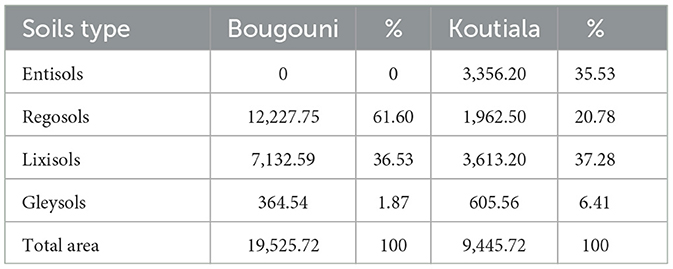
Soil type is an important input in identifying suitable areas for irrigation development in reference to its water-holding capacity and other associated physiochemical characteristics (Attia et al., 2022). The coarse-resolution PIRT composite soil map of 1:500,000 was downscaled into 1:200,000 using the Topographic Positioning Index (TPI) method developed by Jenness (2006). After downscaling, four soil types were identified in the Koutiala district with Lixisols as dominant (37.28%), while the dominant soil type in Bougouni was Regosols (61.60%) (Table 2).
2.3.3. Land use and land cover
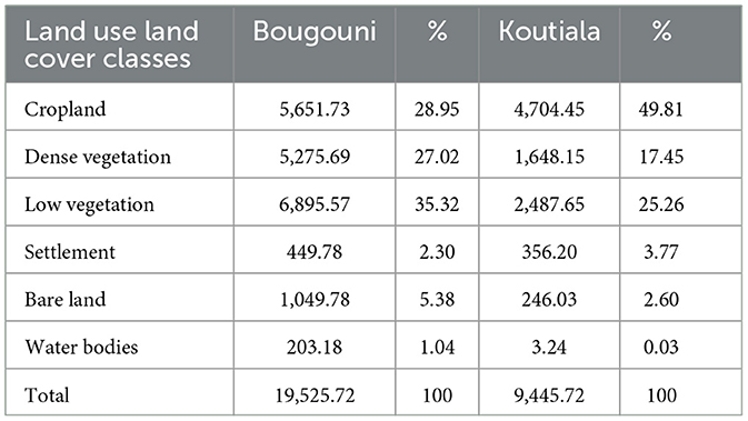
From the 2019 land use and land cover data sourced from satellite imagery, six LULC classes were identified and later mapped after inferring with the ground truth data obtained from local extension agents, authors' know-how of the studied districts, and GIS specialists at the Institut d'Economie Rurale (IER). The major LULC class in both districts are Low vegetation, Cropland, and Dense vegetation (Table 3). Cultivation area accounts for nearly 30 and 50% of the total area for Bougouni and Koutiala districts, respectively. Between the years 1998 to 2019 population density increased by over 100% (i.e., from 16 to 32 inhabitants per km2 for Bougouni, and 40–85 inhabitants per km2 for Koutiala district).
2.3.4. Rainfall
Figure 2 depicts the isohyet distribution of mean annual rainfall in the two districts for the 1983–2021 period. The rainfall amount decreases from south to north and highlights a contrast between the two districts.
2.3.5. Slope
The slope is another important factor in selecting the optimal location for solar-based irrigation technology investment as it directly influences the runoff-generating mechanism over catchments and recharging of aquifers (Carrillo et al., 2021). In addition, with increased land elevation, challenges related to accessibility arise and the potential for investment mainly in rural areas will be reduced (Zoghi et al., 2015). The higher slope of the surface leads to less recharging capacity in the below aquifers and leads to higher investment and operational costs. In the Boolean analysis, the lands with a slope of < 5% were considered suitable (Table 4).
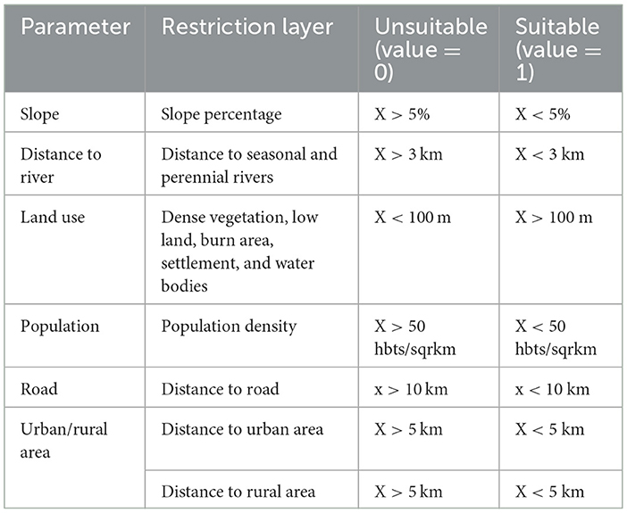
Table 4. Restriction factors for site selection using the Boolean model (based on literature and authors' understanding of the study area).
2.3.6. Urban/rural settlements
Building solar-based irrigation technologies closer to settlement areas affects future development and urban area expansion (Uyan, 2013). On the other hand, investment areas with long distances from residential areas are not economically feasible, the proximity to residential areas could be important (Zoghi et al., 2015). Therefore, areas with a distance >5 km were considered to be unsuitable for solar-based investments through the Boolean logic (Table 4).
2.3.7. Distance to roads
Proximity to roads has a better economic benefit for agricultural investments (Ma et al., 2005). Solar-based irrigation systems should not be built in areas with difficult access (Asakereh et al., 2014). Proximity to transport lines will reduce costs related to the operation, equipment loading, and personnel transport (Zoghi et al., 2015). The map layer related to this factor was created using a transport map of the study area. Land areas with a distance between 1 and 10 km from the roadside were considered to be suitable using the Boolean model (Table 4).
2.3.8. Distance to rivers
The distance to rivers is important because, in areas where rivers exist, recharging capacity and aquifer storage are high. Similarly, better access to surface water resources improves the economic feasibility of expanding the irrigation system (Paul et al., 2020). Attia et al. (2022) considered the Niger River as a base river in Mali in their mapping of land suitability at the national level. Other works, such as IWMI (2019) attempted to consider areas with < 14 km from the nearby streams as suitable for irrigation development. In the present study, the distance to rivers map was built by buffering 200 m to 3 km from the stream networks as suitable areas using the Boolean model. This approach is very similar and in agreement with a recent publication by Negasa and Wakjira (2021) that stated land areas within a 10 km distance from surface water sources are highly suitable for irrigation development in most SSA catchments.
2.3.9. Solar irradiation
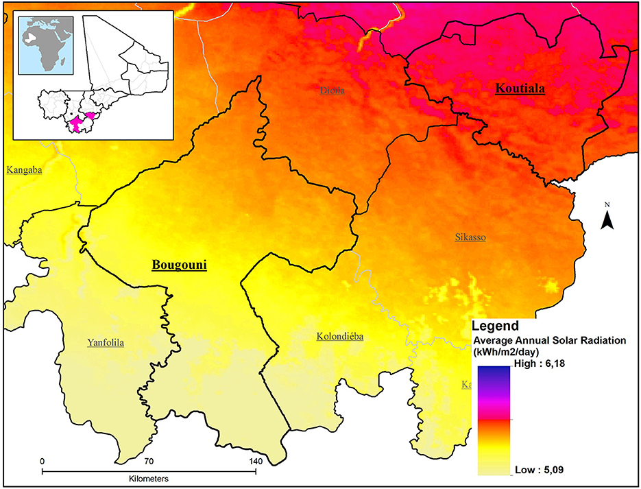
Solar energy-based installation sites must generate an adequate amount of energy to ensure their long-term viability for supporting the required demand. The amount of solar irradiation received on the earth's surface determines the amount of solar energy that can be converted to electricity. US National Renewable Energy Laboratory (NREL) classified values in kWh/m2/day into four categories: moderate (< 4), good (4–5), very good (5–6), and excellent (>6) (Phuangpornpitak and Tia, 2011). The solar irradiation map (Figure 3) retrieved from the World Climate database (Fick and Hijmans, 2017) showed that solar irradiation was between 5.08 and 6.18 kWh/m2/day throughout the area in the two districts. The mean monthly sunshine duration computed from historical long-term data records (2000–2019) in both districts shows the highest and lowest sunshine durations in November (8.81 h) and August (6.93 h) respectively.
2.3.10. Integration of multiple inputs
A multiple-criteria-decision-making tool in a GIS environment was used to analyze and establish criterion and restriction factors in identifying suitable agricultural areas to implement SBISs. As an important step of the site selection criterion, a Boolean decision-making method as illustrated by Noorollahi et al. (2016) and Flora et al. (2021) was used to restrict sites that are not suitable to implement the technology (Table 4). Boolean logic converts information from each input raster map into binary forms of 0 and 1 (True or False). The excluded areas (restricted areas) were assigned a value of 0 while other areas (suitable areas) are assigned a value of 1 (Barakat et al., 2017). In the Boolean model (Flora et al., 2021), a land use map was used as a restriction factor to avoid: Dense vegetation, Water bodies, and Settlement areas, with a buffer of 100 m (Table 4). The maximum likelihood algorithm based on samples collected in Google Earth imagery and expert-based knowledge was used to extract the area of each identified LULC class using individual subset areas. The resulting map is a binary map because each location is either satisfactory or not (Shahabi et al., 2014). In the end, to prepare the final Boolean suitability map, an operator in a GIS toolbox was used to combine all layers to render the final product (Mattikalli et al., 1995; Zaidi et al., 2015) (Figures 4, 5). Model outputs at the district level were compared with previously published outputs that exist at the national level (IWMI, 2019; Attia et al., 2022). Knowledge of the study area was used as another validation option to determine the reliability of model outputs (Pramanik, 2016).
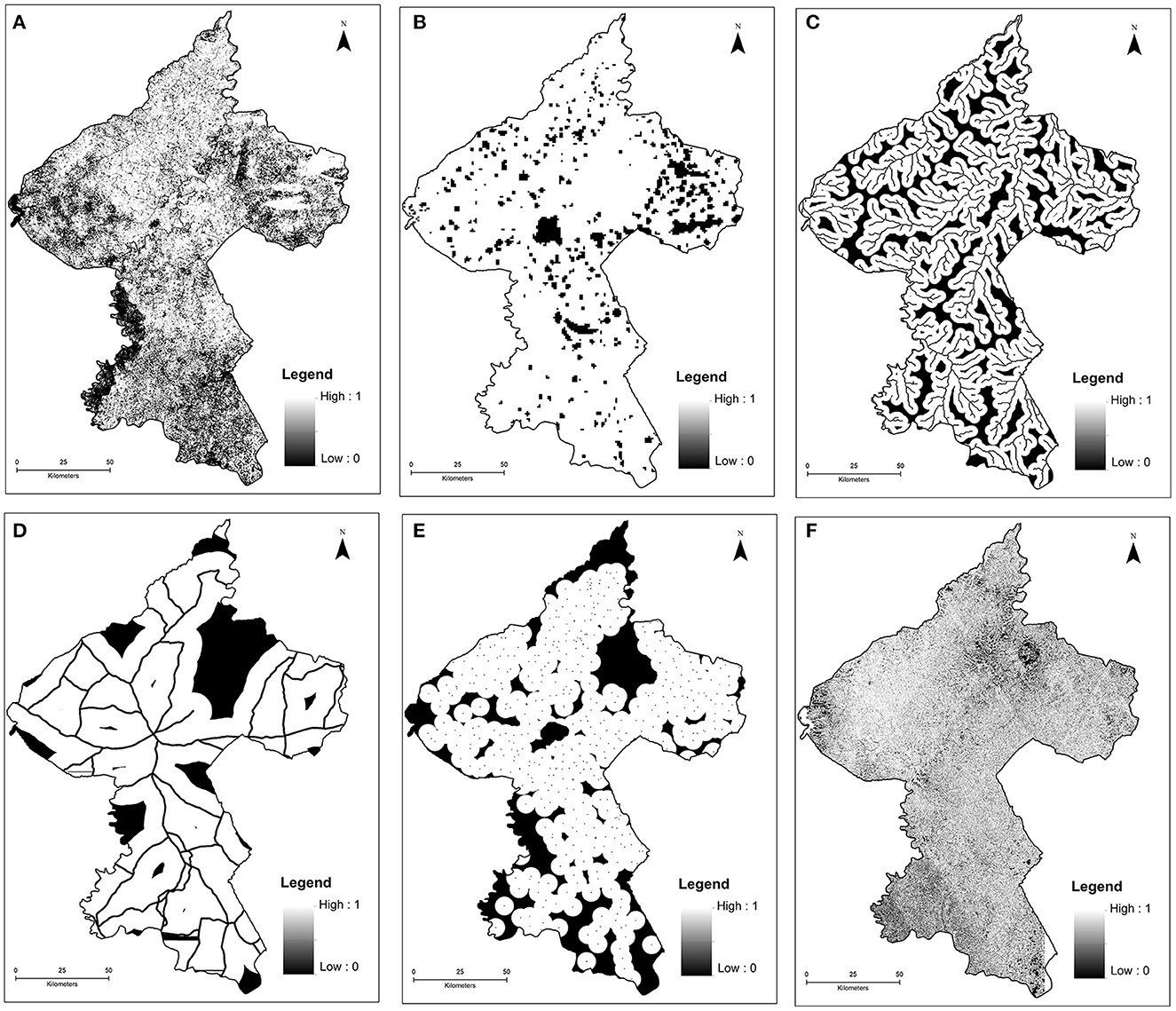
Figure 4. Restricted areas eliminated by Boolean Model (Bougouni district): (A) Land use land cover, (B) population density, (C) river network, (D) roads, (E) settlement, (F) slope.
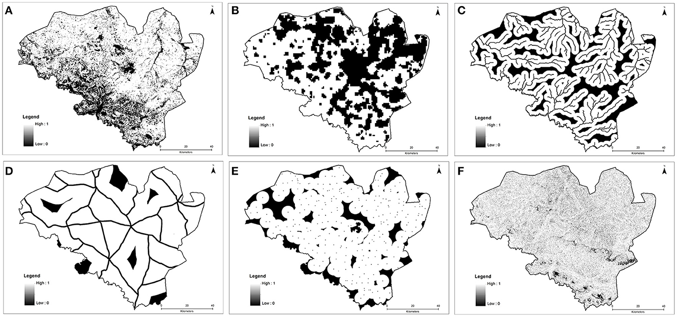
Figure 5. Restricted areas eliminated by Boolean Model (Bougouni district): (A) Landuse land cover, (B) population density, (C) river network, (D) roads, (E) settlement, (F) slope.
3. Results
3.1. Agricultural practices using solar-based irrigation systems
The use of SBISs in rural Mali was recent, with a few years (4.5), and was on a limited land area (0.15 ha). Water was always available for household domestic use (60%), livestock water (28%), and irrigation (15 %). Female farmers are better users (64%) of irrigation systems mainly for vegetable production. The two main crops that farmers practice SBISs are Onion (49%) and Tomato (27%). Over the studied water sources in 112 farm fields, the depth of wells to irrigate vegetable crops vary from an average shallow well-depth of 19 meters to a deep well of 94 meters. The mean irrigation interval practiced by the majority of farmers (90%) was 14 h.
Water productivity according to farmers' perception was low. Summary statistics on water use and yield for major vegetable crops are shown in Table 5. The actual water use during the growing period was compared with the minimum water requirement published by the FAO database (Brouwer and Heibloem, 1986). For all crops, the actual amount of water applied was < 50% of the required minimum amount. The majority of interviewed rural households (67%) however indicated they get sufficient water from wells for irrigation practices. Few farmers witnessed dryness of soil when the interval of irrigation exceeds 2 days, implying that irrigation practices were not following proper scheduling techniques. The yield obtained with farmers' irrigation technique was much less than the national average as well; 19.5 tons/ha for Onion, and 16.5 tons/ha for Tomato (FAOSTAT, 2020). While it was possible to get production data mainly yield (Table 5), data for stover yield of Onion, Pepper and Amaranth were not available, as the leaves of these crops were directly consumed by farmers at different times. The stover left from household consumption was used for livestock feed (73%) and the remaining manure was used to improve soil nutrients.

Table 5. Summary statistics on water productivity for main vegetable crops using solar energy in rural Mali.
3.2. Socio-economics of implemented solar-based irrigation systems
Results of the socio-economic analysis revealed that the head of the household makes the majority of decisions about land ownership and the use of SBISs. Under the rural Malian context, household farmland belongs to the head of the family, which in the majority of cases (95%) is an adult male. Areas not under agriculture belong to the chief of the village who makes decisions on land allocation for various purposes including the implementation of SBISs. From a total of 112 farm households, the majority (65%) responded that vegetable production from the irrigation systems was controlled by the producer. The head of the household is the next person to control production. More than 56% of respondents highlighted that the producer decides on types of vegetable production. While few farmers (21%) directly fund the construction of the irrigation system on their farmland, project-initiated implementation of SBISs (77%) was established on the communal property with a decision that came from the village chief. Regarding awareness, communities are well-informed about the usefulness of SBISs. The majority (63%) responded that information comes from multi-stakeholder discussion forums and farmer-to-farmer interactions.
Over 50% of vegetables produced under SBISs are for sale. Pepper, African Eggplant, Tomato, and Okra are for sale in the majority of cases. Household consumption is relatively higher for Lettuce (59%), Onion (53%), and Amaranth (51%). With the available SBISs, the production of vegetables increased household income. The average income of each vegetable grower household during the dry season was $56 (Tomato), $60 (Onion), and $69 (Pepper). The maximum sale value was $175 (Tomato), and $260 for the other two crops. Analyzed data further revealed that SBISs contributed over 40% of household income for 31% of the respondents. Eighteen percent indicated 30% of income from the sale of vegetable crops. Additionally, 14 and 15% of respondents indicated that solar irrigation system increased their income by 20 and 10%, respectively. For the other 22% of respondents, agricultural income increased by 5%.
The use of SBISs in rural Mali had challenges as well. Fifty-five percent of respondents noted that they lacked basic skills for maintenance work in case of faulty operations or breakage of part of the systems. It was also quite common to see conflicts arising mainly on the use of donor-funded installations on land provided by the village chief. Over 86% of respondents indicated that there are conflicts on the use of the SBISs. Conflicts arose mainly on the amount and timing of irrigation for different farms owned by different farmers. There are also disagreements on the service fee to be paid to a technician in case of systems component breakdown, and few users of the system were unwilling to make a monetary contribution toward replacing damaged parts. Respondents recommended the need to have appropriate training programs on the operation of the SBISs. In addition, guidelines related to water use and systems maintenance for long-term use were recommended to be developed at the village council level (see for example Umutoni and Ayantunde, 2018).
3.3. Land area suitable for solar-based irrigation systems
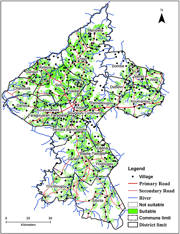
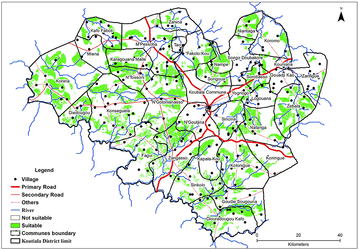
Quite a significant area of the landscape was found to be suitable for the implementation of SBISs in each district. Suitable land area was assessed using the Boolean method using various data sets. Land areas extracted from the combination of Boolean maps have been placed on the raster layers of fuzzy maps. Therefore, the unrestricted areas determined by Boolean overlay were evaluated by fuzzy functions. As shown in Table 6 and Figures 6, 7, nearly 22% of the land area in Bougouni is suitable to implement SBISs. The figure in Koutiala is 18%. In this study, the evaluation criteria were determined and categorized based on the authors' experience and reviews from the limited available information. In the context of Mali, communes are the lower administrative structure next to districts. Villages are clustered in each commune, as such the suitability maps of Figures 6, 7 show the location of villages, names, and boundary limits of each commune. As SBISs are implemented at the village level, each suitability map provides useful guidance to target villages. Villages located in the north, north-western and central parts of the Bougouni district and the eastern and southern parts of Koutiala are found to be suitable for the implementation of SBISs. These results confirmed the findings made at the national level by Attia et al. (2022) that for example in the Sikasso region suitable areas for irrigation development using solar energy are parts located in the northeastern and southern parts. With regards to land use management practices, areas identified as not suitable for SBISs can be reforested to prevent land degradation caused by soil erosion and hence enhance the ecosystem of the landscape by acting as aquifer recharging zones.
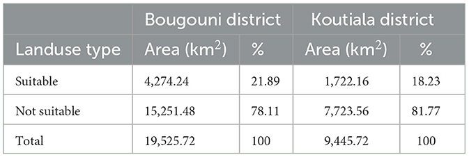
Table 6. Area and percentage of suitable land for solar-based irrigation technology in Bougouni and Koutiala districts.
4. Discussion
4.1. Prospects for SBISs development in Mali
The agricultural system in Mali heavily relies on rainfed agriculture which suffers from land degradation and a limited contribution from the small-scale irrigation system. Rising population growth and increased fragmentation of household farmland necessitate special and urgent attention to the use of CSA practices that include SBISs (IWMI, 2019; Attia et al., 2022). In communities with large household sizes (for example the average in southern Mali is 27), increasing agricultural practices with irrigation-based technologies would ensure better household food security. Most rural Malians practice traditional irrigation systems except for a few donor-funded projects. Due to the limited water lifting systems and scarce availability of water in most shallow wells, the SBISs are practiced once a year in the majority of farm fields (69%).
Irrigation practices using solar energy are still considered by rural farmers as complementary to rainfed agriculture. However, the result of our study highlighted that ~20% of the available land area in the two districts is suitable for solar-based irrigation investment. This potential, together with the untapped groundwater resource in Mali (Birhanu and Tabo, 2016), if properly managed and appropriate investments are in place, would be a game changer for the Malian agricultural system. Groundwater reserve in Mali is an untapped resource requiring due consideration along with other management practices in the changing climate condition.
Promotion and scaling of SBISs, however, are limited by the low rate of literacy level among most rural communities. The technology requires skills in implementation, maintenance, and use. However, 46% of the studied districts' rural communities do not have formal education (Sanogo et al., 2021). In situations when there are no industries or equivalent employers to provide local people with income-generating opportunities, the implementation of small-scale SBISs with the provision of required skills could be a useful option to enhance the livelihood of rural communities. This needs to include the introduction of low-cost soil water sensors that are useful to determine the minimum amount of water and frequency of irrigation (Adimassu et al., 2020; CSIRO, 2021).
The other limitation is the availability of suitable land. Land requirements, considered environmental factors, have been identified as one of the most critical factors for irrigation investments (Kahraman et al., 2009; Rabia et al., 2013). Despite being a major constraint in most developmental projects (Brewer et al., 2015), land use type is the foundation to plan and allocate land for diverse investment options (Tahri et al., 2015). For example, land with appropriate climate conditions for solar energy investments may have a lower value if the land use factor is taken into account (Carrión et al., 2008). Additionally, the dominant soil types in both districts, i.e., Regosols (in Bougouni), and Lixisols (in Koutiala) are characterized by low nutrient status and storage capacity and are susceptible to erosion. In this case, areas with Haplic Lixisols, Gleysols, and Ferric Luvisols were found to be suitable for solar-based irrigation development with the additional application of organic manure and mulches (Jalloh et al., 2011). In particular, Gleysols that are found in low-lying landscape positions with shallow groundwater reserves are better sites as they contain relatively higher organic matter and available nutrients (Jalloh et al., 2011).
Areas receiving annual rainfall >800 mm were found to be suitable as well. However, the spatial and temporal variability of rainfall as evidenced in southern Mali (Ebi et al., 2011; Akinseye et al., 2020; Sanogo et al., 2021) could be a limiting factor to recharge groundwater aquifers. This could also impact the sustainability of SBISs. As smallholder farmers cannot afford hydrocarbon-energized motor pumps or electrical pumps and the affordability of solar panels in many rural places as explained by Schmitter et al. (2018) makes SBISs to be an emerging climate-smart technology for most rural Malian populations. Hence, for a better result, the output of the study needs to be integrated with other intervention measures such as good agronomic practices (Traore et al., 2017) and landscape-based soil and water conservation practices (Traore and Birhanu, 2019; Birhanu et al., 2022).
4.2. SBISs as a game changer for smallholder agriculture in sub-Sahara Africa
In SSA, innovative irrigation systems are essential to secure smallholder farmers' year-round food production to contribute to the increased demand for food. SBISs are proven to potentially be a game changer for SSA smallholder agriculture from several aspects. SBISs are alternatives enabling smallholder farmers to grow more crops in a year by utilizing abundant sunlight and groundwater, mitigating climate change by reducing CO2 emissions (Brunet et al., 2018). SBISs can provide clean irrigation to millions of farmers, empowering their adaptive and resilient capacity by raising agricultural productivity and their incomes (Ockwell et al., 2018). SBISs can open new avenues of opportunity and potential for agricultural growth while transforming the entire range of farming systems in SSA.
Activating SBISs' game-changer potential, however, requires a long-term commitment and comprehensive ingenuity of thought and action, time, and determination across scales. Several attempts are being undertaken in SSA countries for the installation of electric pumps fed by solar energy and modern irrigation system to promote renewable energy and water use efficiency in agriculture (Noubondieu et al., 2018; Mugisha et al., 2021). Investments in west African countries (e.g., Ghana, Senegal, Mali, Gambia) focus on multiple initiatives for testing, de-risking, subsidizing, and analyzing policy reform to sustainably scale solar-powered pumps (Brunet et al., 2018; Lefore et al., 2021). SBISs as game-changer must have the ability to manage uncertainties and overcome obstacles. Enabling this ability requires adaptive approaches to overcome systemic barriers related to the lack of contextually relevant innovation bundles, appropriate end-user financing, policy frameworks biased toward large-scale irrigation and rain-fed agriculture, weak market linkages, nascent private sector investment and increasing competition for water among sectors (IWMI, 2021a). It also needs to integrate public, research, and private sector actors to respond to diverse incentives and environmental trade-offs with the underground water depletion and e-wastes (Minh et al., 2020; Lefore et al., 2021) and improve stakeholder coordination, enact more effective policies, and facilitate integration within the value chains and across sectors (Izzi et al., 2021).
In the case of Mali, enabling SBISs as a game-changer is driven by viable business and investment opportunities, appropriate finance tools, and market integration for solar entrepreneurs and irrigators. There is a growing presence of private sector solar technologies suppliers but the solar technology market can grow to reach many farmers directly when the demand for and supply of SBISs are matched. Understanding the diversity of farmers' SBISs demands, coupled with the solar irrigation suitability map (IWMI, 2021b) helps the suppliers to prioritize geographical areas for their marketing activities and business investments.
Farmers' demands are different in terms of the amount of water needed, land and water access, pump preferences, and capacity to pay for the SBISs. Tailoring the supply business models to different demands and abilities to invest is one of the necessary conditions to unpack the market bottlenecks. For example, in the areas where resource-limited and resource-poor farmers can access shallow groundwater like in areas of Dogo, Kokele, and Sibirila of Bougouni district, and N'golonianasso and M'Pessoba communes of Koutiala district, the business models should focus on supplying the solar-powered pumps with low capacity to match these farmers' ability to invest.
Finally, accelerating the SBISs requires an enabling environment in which domestic manufacturers, irrigation and input suppliers, and small processing businesses can grow. Sustainable financing models help de-risk private sector investments in irrigation markets, especially products and services that support gender and youth inclusion. Win-win partnerships between entrepreneurs, farmer groups, cooperatives, and private and public sector actors help optimize the engagement of private sector companies that supply different equipment along the continuum of agricultural water management, creating a more robust irrigation market for farmers. Multi-stakeholder dialogues and platforms are ways to engage diverse business actors to increase market density and integration (Minh et al., 2020). They also encourage collaboration and learning to drive responsive innovations to address social and gender inequality, economic empowerment, water governance, and multi-sector/stakeholder coordination to accommodate local contexts, diverse partners and stakeholders, and emerging needs for feasible and sustainable SBISs (Lefore et al., 2021).
5. Conclusions and recommendations
The study focused on the understanding of irrigation practices based on farmers' perceptions, and the identification of suitable areas for solar-based irrigation systems in the districts of Bougouni and Koutiala of southern Mali. Multi-criteria-decision-making approach was employed in a Geographical Information System (GIS) environment to provide spatial information on areas suitable for solar-based irrigation systems. With the limited available data, this study demonstrated, the investment in solar-based irrigation systems brought improvements in enhancing socio-economic status and reduction in economic vulnerabilities. In each district, nearly one-fifth of the landscape is suitable for the installation of solar-based irrigation systems. The generated suitability maps of the districts provide needed input to support planning and sustainable implementation of low-cost solar-based irrigation systems as a climate-smart technology. For sustainable agricultural development in rural economies, the results of the study need to be integrated with improved agronomic management practices and landscape-based soil and water conservation techniques. Additionally creating an enabling environment that facilitates sustainable financing mechanisms helps to support gender and youth inclusion in the use of solar-based irrigation systems. The findings of the study would benefit further from an investigation on a cost-benefit analysis that helps to promote the uptake of the technology by an ordinary rural farmer. Training programs on the operationalization of the system and the development of guidelines on water use and system maintenance are necessary criteria to ensure long-term usage and scale the technology in wider suitable landscapes.
Data availability statement
The original contributions presented in the study are included in the article/supplementary material, further inquiries can be directed to the corresponding author.
Author contributions
BB and KS designed the study outline beginning with defining the objectives and identifying the different data requirements. ST contributed to the spatial data collection and analysis. KS administered socio-economic data and conducted the analysis. BB, KS, and ST contributed to the analysis and interpretation of socio-economic and spatial data. MT contributed to the discussion section of the manuscript. The manuscript was written by BB. A content revision was provided by FK. All authors have read and accepted the final version of the manuscript.
Funding
This work was supported by the Africa Research in Sustainable Intensification for the Next Generation (Africa RISING) project in Mali. The agreement was made between the International Institute of Tropical Agriculture (IITA) and the International Crops Research Institute for Semi-Arid Tropics (ICRISAT) under Prime Agreement No. AID-BFS-G-11-00002 from USAID (Prime Sponsor) for collaboration in implementation under the Project: Sustainable Intensification of Key Farming Systems in the Sudano-Sahelian Zone of West Africa (BB is the principal investigator of the project in Mali).
Acknowledgments
The authors are grateful for the financial support provided by the United States Agency for International Development (USAID) through the International Institute of Tropical Agriculture (IITA). The Science and Technology Faculty of Bamako University deserve special thanks for allowing us to use the institute's spatial data and GIS and remote sensing facilities. The authors would like to thank Dr. Geetika Sareen, who is the Senior Manager in Communications & Knowledge Management at ICRISAT for her valuable support in proofreading the manuscript and providing editorial service. We are also grateful to Dr. Bekele H. Kotu, the manuscript's editor.
Conflict of interest
The authors declare that the research was conducted in the absence of any commercial or financial relationships that could be construed as a potential conflict of interest.
Publisher's note
All claims expressed in this article are solely those of the authors and do not necessarily represent those of their affiliated organizations, or those of the publisher, the editors and the reviewers. Any product that may be evaluated in this article, or claim that may be made by its manufacturer, is not guaranteed or endorsed by the publisher.
References
Adimassu, Z., Balana, B. B., Appoh, R., and Nartey, E. (2020). The use of the wetting front detector as an irrigation-scheduling tool for pepper production in the Upper East Region of Ghana: evidence from field experiment and farmers' perceptions. Irrig. Drain. 69, 696–713. doi: 10.1002/ird.2454
Akinseye, A. F., Hakeem, A. A., Traore, P. C. S., Agelee, S., Birhanu, Z. B., and Whitbread, A. (2020). Improving sorghum productivity under changing climatic conditions: a modelling approach. Field Crops Res. 246, 107685. doi: 10.1016/j.fcr.2019.107685
Asakereh, A., Omid, M., Alimardani, R., and Sarmadian, F. (2014). Developing a GIS-based fuzzy AHP model for selecting solar energy sites in Shodirwan region in Iran. Int. J. Adv. Sci. Technol. 68, 37–48. doi: 10.14257/ijast.2014.68.04
Attia, A., Qureshi, A. S., Kane, A. M., Alikhanov, B., Kheir, A. M. S., Ullah, H., et al. (2022). Selection of potential sites for promoting small-scale irrigation across Mali using remote sensing and GIS. Sustainability 14, 12040. doi: 10.3390/su141912040
Barakat, A., Hilali, A., El Baghdadi, M., and Touhami, F. (2017). Landfill site selection with GIS-based multi-criteria evaluation technique. A case study in Béni Mellal-Khouribga Region, Morocco. Environ. Earth Sci. 76, 413. doi: 10.1007/s12665-017-6757-8
Birhanu, B., Traoré, K., Sanogo, K., Tabo, R., Fischer, G., and Whitbread, A. (2022). Contour bunding technology-evidence and experience in the semiarid region of southern Mali. Renew. Agric. Food Syst. 37, S55–S63. doi: 10.1017/S1742170519000450
Birhanu, B. Z., and Tabo, R. (2016). Shallow wells, the untapped resource with a potential to improve agriculture and food security in southern Mali. Agric. Food Secur. 5, 5. doi: 10.1186/s40066-016-0054-8
Birhanu, B. Z., Traoré, K., Gumma, M. K., Badolo, F., Tabo, R., and Whitbread, A. M. (2019). A watershed approach to managing rainfed agriculture in the semiarid region of southern Mali: integrated research on water and land use. Environ. Dev. Sustain. 21, 2459–2485. doi: 10.1007/s10668-018-0144-9
Brewer, J., Ames, D. P., Solan, D., Lee, R., and Carlisle, J. (2015). Using GIS analytics and social preference data to evaluate utility-scale solar power site suitability. Renew. Energy 81, 825–836. doi: 10.1016/j.renene.2015.04.017
Brouwer, C., and Heibloem, M. (1986). Irrigation Water Management: Irrigation Water Needs. Training Manual. Rome: Food and Agriculture Organization of the United Nations, 3.
Brunet, C., Savadogo, O., Baptiste, P., and Bouchard, M. A. (2018). Shedding some light on photovoltaic solar energy in Africa–A literature review. Renew. Sustain. Energy Rev. 96, 325–342. doi: 10.1016/j.rser.2018.08.004
Carrillo, G., Troch, P. A., Sivapalan, M., Wagener, T., Harman, C., and Sawicz, K. (2021). Catchment classification: hydrological analysis of catchment behavior through process-based modeling along a climate gradient. Hydrol. Earth Syst. Sci. 15, 3411–3430. doi: 10.5194/hess-15-3411-2011
Carrión, J. A., Estrella, A. E., Dols, F. A., Toro, M. Z, Rodríguez, M, and Ridao, A. R. (2008). Environmental decision-support systems for evaluating the carrying capacity of land areas: optimal site selection for grid-connected photovoltaic power plants. Renew. Sustain. Energy Rev. 9, 2358–2380. doi: 10.1016/j.rser.2007.06.011
Cooper, M. W., and West, C. T. (2017). Unraveling the Sikasso Paradox: agricultural change and malnutrition in Sikasso, Mali. Ecol. Food Nutr. 56, 1–23. doi: 10.1080/03670244.2016.1263947
CSIRO (2021). Centre for Scientific and Industrial Research Organization. Chameleon Soil Water Sensor. Available online. https://www.csiro.au/en/research/plants/crops/farming-systems/chameleon-soil-water-sensor (accessed December 12, 2022).
DNH (2016). Fiche descriptive du programme conjoint d'appui à la GIRE (PCA-GIRE), Ministère de l'Energie et de l'Eau, Mali. Available online at: https://dnhmali.org/IMG/docx/-6.docx (accessed September 22, 2022).
Ebi, K. L., Padgham, J., Doumbia, M., Kergna, A., Smith, J., Butt, T., et al. (2011). Smallholders adaptation to climate change in Mali. Clim. Change 108, 423–436. doi: 10.1007/s10584-011-0160-3
FAOSTAT (2020). Available online at: http://www.fao.org/faostat/en/#data/QCL (accessed October 18, 2022).
Fick, S. E., and Hijmans, R. J. (2017). WorldClim 2: new 1km spatial resolution climate surfaces for global land areas. Int. J. Climatol. 37, 4302–4315. doi: 10.1002/joc.5086
Flora, F. M. I., Donatien, N., Tchinda, R., and Hamandjoda, O. (2021). Selection wind farm sites based on GIS using a boolean method: evaluation of the case of Cameroon. J. Power Energy Eng. 9, 1–24. doi: 10.4236/jpee.2021.91001
Gadeberg, M. (2020). Solar-Powered Irrigation Could Boost Climate Resilience for Millions. Available online at: https://www.agrilinks.org/post/solar-powered-irrigation-could-boost-climate-resilience-millions (accessed October 02, 2022).
Girma, R., Gebre, E., and Tadesse, T. (2020). Land suitability evaluation for surface irrigation using spatial information technology in Omo-Gibe River Basin, Southern Ethiopia. Irrig. Drain. Syst. Eng. 9, 1–10. doi: 10.37421/idse.2020.9.245
Hagos, Y. G., Mengie, M. A., Andualem, T. G., Yibeltal, M., Linh, N. T. T., Tenagashaw, D. Y., et al. (2022). Land suitability assessment for surface irrigation development at Ethiopian highlands using geospatial technology. Appl. Water Sci. 12, 98. doi: 10.1007/s13201-022-01618-2
IITA (2016). Africa Research in Sustainable Intensification for the Next Generation West Africa Regional Project. Proposal for a Second Phase, 2016–2021. Nairobi: ILRI. Pp51. Available online at https://hdl.handle.net/10568/77116 (accessed February 19, 2022).
IITA ILRI (2018). Footprints of Africa RISING—Phase I: 2011–2016. Ibadan: IITA. Available online at: https://hdl.handle.net/10568/92816 (accessed December 15, 2022).
INSTAT (2011). Institut national de la statistique, 4ème recensement général de la population et de l'habitat du MALI (RGPH). Available online at: https://dataspace.princeton.edu/handle/88435/dsp01ms35tb90t (accessed October 02, 2022).
Institut National de la Statistique (2009). 4 Ème Récensement General de La Population et de l'Habitat Du Mali (RGPH). Available online at: http://www.instat-mali.org/contenu/rgph/repvil09_rgph.pdf (accessed October 10, 2022).
IWMI (2019). Suitability for Farmer-Led Solar Irrigation Development in Mali. Colombo: International Water Management Institute (IWMI). CGIAR Research Program on Water, Land, and Ecosystems (WLE), 4. Avalable online at: https://hdl.handle.net/10568/101594 (accessed October 2, 2022).
IWMI (2021a). Adaptive Scaling to Achieve System Transformation in One CGIAR. Colombo: International Water Management Institute, 8.
IWMI (2021b). Assessing the Potential for Sustainable Expansion of Small-Scale Solar Irrigation in Segou and Sikasso, Mali. Colombo: International Water Management Institute, 8.
Izzi, G., Denison, J., and Veldwisch, G. J. (2021). The Farmer-led Irrigation Development Guide: A What, Why and How-to for Intervention Design. World Bank. Available online at: https://pubdocs.worldbank.org/en/751751616427201865/FLID-Guide-March-2021-Final.pdf (accessed October 02, 2022).
Jalloh, A., Rhodes, E. R., Kollo, I., Roy-Macauley, H., and Sereme, P,. (2011). Nature and Management of the Soils in West and Central Africa: A Review to Inform Farming Systems Research and Development in the Region. Dakar: Conseil Ouest et Centre Africain pour la Recherche et le Development Agricoles/West and Central African Council for Agricultural Research and Development (CORAF/WECARD). Available online at: https://issuu.com/coraf/docs/nature_and_management_of_soils_in_w (accessed December 14, 2022).
Jenness, J. (2006) Topographic Position Index (tpi_jen.avx) Extension for ArcView 3.x, v. 1.3a. Jenness Enterprises. Available online at: http://www.jennessent.com/arcview/tpi.htms (accessed December 10, 2022).
Kahraman, C., Kaya, I, and Cebi, S. (2009). A comparative analysis for multi-attribute selection among renewable energy alternatives using fuzzy axiomatic design and fuzzy analytic hierarchy process. Energy 34:1603–1616. doi: 10.1016/j.energy.2009.07.008
Kamaraju, M., Bhattacharya, A., Reddy, G. S., Rao, G. C., Murthy, G., and Rao, T. C. M. (1996). Ground-water potential evaluation of West Godavari District, Andhra Pradesh State, India—A GIS Approach. Groundwater 34, 318–325. doi: 10.1111/j.1745-6584.1996.tb01891.x
Lefore, N., Closas, A., and Schmitter, P. (2021). Solar for all: a framework to deliver inclusive and environmentally sustainable solar irrigation for smallholder agriculture. Energy Policy 154, 112313. doi: 10.1016/j.enpol.2021.112313
Ma, J., Scott, N. R., DeGloria, S. D., and Lembo, A. J. (2005). Siting analysis of farm-based centralized anaerobic digester systems for distributed generation using GIS. Biomass Bioenergy 28, 591–600. doi: 10.1016/j.biombioe.2004.12.003
Mattikalli, N. M., Devereux, B. J., and Richards, K. S. (1995). Integration of remotely sensed satellite images with a geographical information system. Comput. Geosci. 21, 947–956. doi: 10.1016/0098-3004(95)00031-3
Minh, T., Cofie, O., Lefore, N., and Schmitter, P. (2020). Multi-stakeholder dialogue space on farmer-led irrigation development in Ghana: an instrument driving systemic change with private sector initiatives. Knowl. Manag. Dev. J. 15, 98–118.
Mugisha, J., Ratemo, M. A., Keza, B. C. B., and Kahveci, H. (2021). Assessing the opportunities and challenges facing the development of off-grid solar systems in Eastern Africa: the cases of Kenya, Ethiopia, and Rwanda. Energy Policy 150, 112131. doi: 10.1016/j.enpol.2020.112131
Murthy, K. (2000). Groundwater potential in a semi-arid region of Andhra Pradesh-a geographical information system approach. Int. J. Remote Sens. 21, 1867–1884. doi: 10.1080/014311600209788
Negasa, G., and Wakjira, G. (2021). Assessment of irrigation land suitability for surface irrigation in Birbir River watershed using geographic information system technique in Oromia Region, Ethiopia. Softw. Eng. 9, 45. doi: 10.11648/j.se.20210902.12
Noorollahi, Y., Yousefi, H., and Mohammadi, M. (2016). Multi-criteria decision support system for wind farm site selection using GIS. Sustain. Energy Technol. Assess. 13, 38–50. doi: 10.1016/j.seta.2015.11.007
Noubondieu, S., Flammini, A., and Bracco, S. (2018). Costs and benefits of solar irrigation systems in Senegal. Dakar: FAO, 28.
Ockwell, D., Byrne, R., Hansen, U. E., Haselip, J., and Nygaard, I. (2018). The uptake and diffusion of solar power in Africa: Socio-cultural and political insights on a rapidly emerging socio-technical transition. Energy Res. Soc. Sci. 44, 122–129. doi: 10.1016/j.erss.2018.04.033
Partey, S. T., Zougmoré, R. B., Ouédraogo, M., and Campbell, B. M. (2018). Developing climate-smart agriculture to face climate variability in West Africa: challenges and lessons learnt. J. Clean. Prod. 187, 285–295. doi: 10.1016/j.jclepro.2018.03.199
Paul, M., Negahban-Azar, M., Shirmohammadi, A., and Montas, H. (2020). Assessment of agricultural land suitability for irrigation with reclaimed water using geospatial multi-criteria decision analysis. Agric. Water Manag. 231, 105987. doi: 10.1016/j.agwat.2019.105987
Phuangpornpitak, N., and Tia, S. (2011). Feasibility study of wind farms under the Thai very small-scale renewable energy power producer (VSPP) program. Energy Proc. 9, 159–170. doi: 10.1016/j.egypro.2011.09.017
PIRT (1986). Projet Inventaire des Ressources Terrestres, Zonage agro-écologique du Mali, Tome 1 +1 carte au 1/1 000 000 INRZFH/DRFH/PIRT. Sotuba, 151.
Pramanik, M. K. (2016). Site suitability analysis for agricultural land use of Darjeeling district using AHP and GIS techniques. Model. Earth Syst. Environ. 2, 56. doi: 10.1007/s40808-016-0116-8
Rabia, A. H., Figueredo, H., Huong, T. L., Lopez, B. A. A., Solomon, H. W., and Alessandro, V. (2013). Land suitability analysis for policy making assistance: A GIS-based land suitability comparison between surface and drip irrigation systems. Int. J. Environ. Sci. Dev. 4, 1–6. doi: 10.7763/IJESD.2013.V4.292
Sanogo, K., Birhanu, B. Z., Sanogo, S., Aishetu, A., and Ba, A. (2021). Spatiotemporal response of vegetation to rainfall and air temperature fluctuations in the Sahel: case study in the forest reserve of Fina, Mali. Sustainability 13, 6250. doi: 10.3390/su13116250
Schmitter, P., Kibret, K. S., Lefore, N., and Barron, J. (2018). Suitability mapping framework for solar photovoltaic pumps for smallholder farmers in sub-Saharan Africa. Appl. Geograp. 94, 41–57. doi: 10.1016/j.apgeog.2018.02.008
Shahabi, H., Keihanfard, S., Bin Ahmad, B., and Amiri, M. J. T. (2014). Evaluating Boolean, AHP and WLC methods for the selection of waste landfill sites using GIS and satellite images. Environ. Earth Sci. 71, 4221–4233. doi: 10.1007/s12665-013-2816-y
Tahri, M., Hakdaoui, M., and Maanan, M. (2015). The evaluation of solar farm locations applying geographic information system and multi-criteria decision-making methods: Case study in southern Morocco. Renew. Sustain. Energy Rev. 51, 1354–1362. doi: 10.1016/j.rser.2015.07.054
Traore, K., and Birhanu, B. Z. (2019). Soil erosion control and moisture conservation using contour ridge Tillage in Bougouni and Koutiala, Southern Mali. J. Environ. Prot. 10, 1333–1360. doi: 10.4236/jep.2019.1010079
Traore, K., Sidibe, D. K., Coulibaly, H., and Bayala, J. (2017). Optimizing yield of improved varieties of millet and sorghum under highly variable rainfall conditions using contour ridges in Cinzana, Mali. Agric. Food Secur. 6, 11. doi: 10.1186/s40066-016-0086-0
Umutoni, C., and Ayantunde, A. A. (2018). Perceived effects of transhumant practices on natural resource management in southern Mali. Pastoralism 8, 8. doi: 10.1186/s13570-018-0115-7
Uyan, M. (2013). GIS-based solar farms site selection using analytic hierarchy process (AHP) in Karapinar region Konya/Turkey. Renew. Sustain. Energy Rev. 28, 11–17. doi: 10.1016/j.rser.2013.07.042
Xie, H., Ringler, C., and Mondal, M. A. H. (2021). Solar or diesel: a comparison of costs for groundwater-fed irrigation in sub-saharan africa under two energy solutions. Earth's Fut. 9, e2020EF001611. doi: 10.1029/2020EF001611
Zaidi, F. K., Nazzal, Y., Ahmed, I., Naeem, M., and Jafri, M. K. (2015). Identification of potential artificial groundwater recharge zones in north western Saudi Arabia using GIS and Boolean logic. J. Afr. Ear. Sci. 111, 156–169. doi: 10.1016/j.jafrearsci.2015.07.008
Zoghi, M., Ehsani, A. H., Sadat, M., Javad Amiri, M., and Karimi, S. (2015). Optimization solar site selection by fuzzy logic model and weighted linear combination method in arid and semi-arid region: a case study Isfahan-IRAN. Renew. Sustain. Energy Rev. 68, 986–996. doi: 10.1016/j.rser.2015.07.014
Keywords: climate-smart agriculture, farmers perception, irrigation, land suitability, solar energy, southern Mali, sustainable intensification, water management
Citation: Birhanu BZ, Sanogo K, Traore SS, Thai M and Kizito F (2023) Solar-based irrigation systems as a game changer to improve agricultural practices in sub-Sahara Africa: A case study from Mali. Front. Sustain. Food Syst. 7:1085335. doi: 10.3389/fsufs.2023.1085335
Received: 31 October 2022; Accepted: 10 February 2023;
Published: 02 March 2023.
Edited by:
Jun He, Yunnan University, ChinaReviewed by:
Damodhara Rao Mailapalli, Indian Institute of Technology Kharagpur, IndiaZhang Yucui, Chinese Academy of Sciences, China
Copyright © 2023 Birhanu, Sanogo, Traore, Thai and Kizito. This is an open-access article distributed under the terms of the Creative Commons Attribution License (CC BY). The use, distribution or reproduction in other forums is permitted, provided the original author(s) and the copyright owner(s) are credited and that the original publication in this journal is cited, in accordance with accepted academic practice. No use, distribution or reproduction is permitted which does not comply with these terms.
*Correspondence: Birhanu Zemadim Birhanu, ei5iaXJoYW51QGNnaWFyLm9yZw==; YmlyaGFudXplbUB5YWhvby5jb20=
 Birhanu Zemadim Birhanu
 Karamoko Sanogo2
 Souleymane Sidi Traore
 Minh Thai
 Fred Kizito