- 1Department of Agricultural Sciences, College of Agriculture and Agri-Industries, Caraga State University, Butuan City, Philippines
- 2Department of Agricultural and Biosystems Engineering, College of Engineering and Geo-Sciences, Caraga State University, Butuan City, Philippines
This paper describes the assessment of climate risks, the vulnerability of farmlands, and the adaptive farming practices to climate change with the use of GIS, field observations, stakeholder consultation and interviews and case documentation. GIS-based climate risk vulnerability assessment maps were generated to pinpoint the areas with the major climate hazards in Agusan del Norte. The vulnerability of the farmlands, and the adaptive capacity of the farms were assessed with index scoring. Also, adaptation to climate change based on the most problematic hazard (flooding) was observed on the two groups of farmers (with and without climate resilient agriculture (CRA)/cropping system adjustments) for cost and benefit comparison. The results show flooding and drought as the significant hazards in Agusan del Norte (Caraga Region) and high vulnerability to these hazards due to low coping mechanisms for most farms. Low adaptive capacity was also observed among these farms. Case-based observations on adaptation in Jabonga, Agusan del Norte revealed that well-timed adjustments to the usual cropping system can increase farm income despite of the flood and inundation for 2–3 months. This study recommends for harmonized measures toward advocating strengthened adaptive capacity for agriculture across Agusan del Norte. Further climate R&D and increasing policy support on climate financing and CRA options are highly encouraged for the agricultural stakeholders to take action. For hard-pressed farmers with constrained access to improved varieties and technologies, timing is potentially essential to circumvent damages from climate change to gain economic and psychosocial benefits with well-timed adaptation measures.
Introduction
Strategies to reduce the impacts of climate change through mitigation and adaptation are necessary to improve the resilience of the agriculture-based communities (Porter et al., 2014 as cited by Escarcha et al., 2018; Aryal et al., 2020), particularly in the various regions in the Philippines. Developing countries with tropical climates like the Philippines are potentially sensitive and vulnerable to these impacts for a lot of reasons (Escarcha et al., 2018). In Mindanao, agricultural development in the north-eastern regions have been continually exposed to different climate hazards such as typhoon, drought, erosion, and pest and diseases brought about by the changing climate, inappropriate cultivation, and land-use practices. These are collectively called human-driven or anthropogenic climate change that can cause great damage to farming and agriculture and exacerbate poverty among the disadvantaged rural population (Barbier and Hochard, 2018; Stuecker et al., 2018). Barbier and Hochard (2018) pointed out climate-induced events with immediate impacts such as floods, droughts and storm surges, and climatic changes with gradual impacts such as temperature and rainfall changes, sea level rise and intrusion as well as soil erosion as damaging to the ill-equipped agriculture and farming population. They have identified the people living in the “less favored agricultural areas (LFAAs)” as extremely vulnerable to climate change events due to management difficulties caused by poor location and resource quality endowments. In 2011–2020, the north-eastern Mindanao region with sporadic LFAAs was subjected to such conditions with typhoons causing tremendous agricultural damage. These experiences of north-eastern Mindanao affirm the expanding vulnerabilities of the agriculture-dependent economy and the farming communities where damages consequently intensify the poverty situation.
The recognition that climate change can negatively affect agricultural production has led governments to build resilience into agricultural systems. In the EU, adaptation is an objective for agricultural units in the region to work out under the Common Agricultural Policy (CAP) 2021–2027 with several portfolios of technologies and approaches to institute farm/agricultural resilience (Tigkas et al., 2020). For the same reason, public investments have been used in the Philippines to strengthen the staple food baskets, particularly the rice sector with irrigation facilities (Perez et al., 2018). On the other hand, cropping systems through crop diversification can potentially improve resilience in two ways: by stimulating biodiversity that can suppress pest outbreaks and dampen pathogen transmission, and by protecting crop production from the effects of climate variability and extreme events (Lin, 2011) with relevant technologies and approaches. For India, crop diversification works as an effective option to crop enterprise resilience, particularly in areas constrained by limited rainfall and high temperature (Birthal and Hazrana, 2019). However, crop diversification as an adaptation strategy is challenged by the incentives to produce with a select few crops and the belief that monocultures are more productive than diversified systems. Such incentives and beliefs can deter the promotion and adoption of crop diversification to reduce climate change impacts.
Meanwhile, adaptation to climatic changes has been studied for behavioral underpinnings as a basis for interventions by the government and other organizations. In the Philippines, Acosta-Michalik and Espaldon (2008) used an agent-based framework with a behavioral component for village farmers in a municipality. In their study, the framework's simulations had provided insights that production support can reduce future vulnerability if matched with appropriate market support. Acosta-Michalik and Espaldon (2008) also reported that the lack of money and information are the most important reasons why available technical adaptation measures in the community fail. However, a participatory approach to managing climate change risks and adaptation requires substantial stakeholders' learning (Grimberg et al., 2018) as well as learning the location requirements of community-based adaptation strategies (Makate, 2020). Downscaling vulnerability and risk assessment to the community and farm level are challenged with these (Tiongco, 2016). The role of forward-looking learning as a critical element for adaptation and resilience in the context of climate change is still being studied. Tschakert et al. (2014) present two linked methodological tools as an assessment of change drivers and participatory scenario building used in a climate change adaptation project in Ghana and Tanzania. Their results suggest that joint exploration, diverse storylines, and deliberation help to expand community-based adaptation lists and strike a balance between hopelessness and a tendency to idealize potential future realities.
In the Philippines, the successful implementation of the government-initiated program on climate change adaptation and mitigation at the regional level requires the active collaboration and support of key research and development institutions within the region (Grimberg et al., 2018; Makate, 2020). Caraga Region is a flood-prone area, thus, flooding is regarded as the major disaster that significantly affects the socio-economic conditions of the region. The guidelines set by the government to allocate funds for disaster risk reduction and management due to climate change is a huge opportunity for financing climate resilient agriculture (CRA) initiatives. However, rational investment planning is required to capitalize on the funds available for this purpose. Geospatial assessment of climate risks, documenting and analyzing climate-resilient agricultural practices and initiatives are important inputs in developing climate change adaptation or mitigation strategies in agriculture. This research developed maps of climate risks for local government units as the basis for CRA investment planning and the capacitation of the stakeholders for enhanced awareness of climate adaptation planning.
Methodology
Research site
The study was done in the province of Agusan del Norte in Caraga Region, Philippines. Caraga Region is in the northeastern part of Mindanao, Philippines with a land area of 18,847 sq.km (National Nutrition Council, 2021). It has five provinces, namely: Agusan del Norte, Agusan del Sur, Surigao del Norte, Surigao del Sur and the Dinagat Island. Aside from being a food and feed basket, the region is widely known as the mining destination and the timber corridor of the Philippines (Varela et al., 2021; Balanay et al., 2022). At present, Caraga Region has a total of 30 registered mining companies (MGB-13, 2020). It provided livelihood to people in the Province of Agusan del Norte and nearby provinces that increased the people's adaptability to climate change. Caraga Region is also responsible for the 65% timber supply across the country, which provides economic benefits to tree farmers and workers in the wood-based industry (Balanay et al., 2022). However, the region is reported to be among the most vulnerable areas in the country due to its location in the Pacific seaboard which is usually hit by typhoons. On average, 20 typhoons hit the Philippines every year.
In this study, climate mapping was piloted in the province of Agusan del Norte due to the interest of finding solutions to surmount the seemingly annual flooding incidence among the agricultural producers. Flood devastation in the key agricultural areas in Agusan del Norte is quite agonizing among the affected farmers with their inability to produce for income during the flood season of 2–3 months. Furthermore, climate maps were prepared for the major commodities such as rice, banana, and corn for Agusan del Norte. In the identification of changes in production practices to be recommended, the observation was focused on the corn producers who were found to be halted in agricultural production during the flood season due to inundation. These farmers were settlers in the municipality of Jabonga, Agusan del Norte. Jabonga has been experiencing massive flooding or inundation of at least a meter high every rainy season for at least 2 weeks.
Geospatial assessment of climate risks
Geo-referenced data on vulnerability to climate risks of the region's agriculture and fisheries sector were collected and organized. These datasets were formed from both primary and secondary sources. The primary data were obtained through interviews and focus group discussions. The component drivers of climate vulnerability such as sensitivity, exposure, and adaptive capacity, were assessed and evaluated using the composite index method to determine the risk and vulnerability levels within the study area. The sensitivity component analysis assumed a high emission scenario by the year 2050. The exposure component was the climate and hydro-meteorological related hazards that normally occur in the province, and adaptive capacity was the up-to-date secondary data from the respective local government units of Agusan del Norte.
The crop sensitivity under climate change employed a species distribution modeling through the Maximum Entropy (MaxEnt). This model underwent a two-step process; the first step was to evaluate the baseline crop suitability using the assumption that a species will most likely exist at a specific site if the environmental conditions are roughly similar to those observed. If the environmental condition where the species is detected in the baseline condition, the second step is to predict the location of the crop species on a particular time slice. The baseline and the future conditions were determined using the WorldClim dataset. Bioclimatic variables were created by processing the monthly rainfall and temperature data to produce more biologically meaningful climate variables (Hijmans et al., 2005). According to O'Donnell and Ignizio (2012), the bioclimatic variables are important parameters for understanding how different species react to climate change. The crop sensitivity index was determined by the difference between the baseline and future suitability to the changing climate conditions. An index ranging from 0.25 to 1.0 indicates a loss in suitability, while the negative direction (−0.25 to −1.0) indicates a gain in suitability, as suggested by Palao et al. (2017) as shown in Table 1.

Table 1. Sensitivity index based on percent change in crop suitability from baseline to future condition.
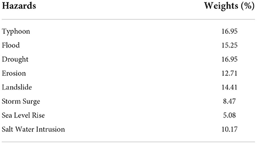
The extent of exposure under pressure from the climate and hydro-meteorological risk was estimated using the combined georeferenced natural hazards such as tropical cyclone, flooding, landslide, storm surge, erosion, and sea-level rise. These hazards were validated during the consultation with the local government unit partners within the study area. Hazards weight were identified through focus group discussions participated by the experts from academe, national government agencies, and private stakeholders. The experts were asked to rate the risk of hazard based on the qualitative assessment using the following criteria: (a) Probability of occurrence; (b) Impact on local household income; (c) Impact on key natural resources to sustain productivity (refers to how key resources such as water quality and quantity, soil fertility, and biodiversity are affected); (d) Impact on food security of the country; and (e) Impact on the national economy. Experts were given a scale of 1–5, with 1 being low risk and 5 being a high probability of impact. Table 2 shows the percentage weight distribution of each hazard in the province. The exposure (hazard) index was determined through a spatially weighted sum of all hazards. For each municipality, the hazard index's value was calculated and normalized using Equation 1. To geo-visualized the hazard index on the map, five equal breaks were categorized as 0–0.20 (very low), 0.20–0.40 (moderate), 0.60–0.80 (high), and 0.80–1.0 (very high).
where: Haznorm = is the normalized value of the hazard index, X = is the original value of the indicator of the municipality, Xmax = is the highest value among all the municipalities, Xmin = is the lowest value among all municipalities.
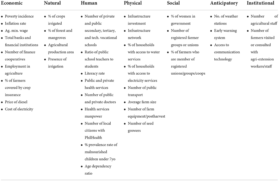
Seven capitals were clustered under Adaptive Capacity (AC) components such as economic, natural, human, physical, social, health, anticipatory, and institutional indicators. As shown in Table 3, the study used these indicators recommended by the Department of Agriculture—Regional Field Office. The value of the AC index was calculated and normalized using Equation 2. The same equal breaks were applied with hazards for the AC component to geo-visualized in the map as 0–0.20 (very low), 0.20–0.40 (moderate), 0.60–0.80 (high), and 0.80–1.0 (very high).
where: ACnorm = is the normalized values of the AC indicators, X = is the original value of the indicator of the municipality, Xmax = is the highest value among all the municipalities, Xmin = is the lowest value among all the municipalities.
All data from these sources were collated based on the methodological guidelines to include climate-risk exposure, sensitivity, and adaptive capacity. The analysis used GIS and climate modeling tools such as the CRVA, which were undertaken at the regional level down to the municipal level. The total climate risk vulnerability (CRV) was computed by adapting the vulnerability concept of Centro Internacional de Agricultura Tropical (CIAT) Southeast Asia using the formula as shown in Equation 3.
where CRVA = is the total climate risk vulnerability of the municipality, S = is the sensitivity of the municipality, E = is the exposure (hazards) of the municipality, AC = is the adaptive capacity of the municipality.
Documenting and analysis of CRA practices
After the climate mapping, farmers were identified to document the climate-resilient agricultural (CRA) practices in the most vulnerable areas in the Province of Agusan del Norte. The selection of these farmers was made considering their vulnerability to the prolonged flood incidence and the mitigation initiatives developed to surmount their vulnerability resulting to income increments helpful during the flood season. The documentation of the CRA practices was carried out with repeated observations in the field and personal interviews. The Municipal Agriculture Office (MAO) of Jabonga facilitated the identification of the farmers to be observed. The intelligent response of these farmers to the flooding incidence in the area caught the attention of the MAO, which led to the farmers' involvement in the project as reference for the CRA practices.
Two farmer-groups were chosen for close observation. One farmer group was assigned as without CRA and another farmer group as with CRA. Seven farmers had been observed under without CRA, who were selected from the barangays of Colorado, Magsaysay and Libas, including the población barangay of Jabonga. For the farmer group of with CRA, the same barangays were the areas considered for the farmer selection. Furthermore, the farmers under the “with CRA” group were divided into two—those combining corn with squash through a well-timed alternate monocropping and intercropping system and those practicing well-timed crop rotation of corn, rice and green corn. The timing of these farming systems was based on the anticipation of rains and flood incidence.
The case study involved five (5) farmers for the alternate monocropping and intercropping system where corn monocropping was adopted in the first cropping season and corn-squash intercropping was done in the second cropping season. In this particular farming system, the squash output was not intended for sale in the market primarily but rather as feed for the hogs during the rainy season. However, the farmers could use their squash product for sale in the market, for household consumption, and for their hogs. The second farming system of crop rotation involved another five (5) farmers for observation. All of their produce were intended for market to obtain additional income to cope with the difficult times during the flood season. The observation period was for two cropping seasons. Data from field observations and interviews were analyzed using cost accounting and cost-benefit analysis (CBA). Means or average values were used in the CBA.
Results and discussion
Climate risk vulnerability assessment (CRVA) of selected major crops in Agusan del Norte
Sensitivity index
Changes in climatic suitability of the selected priority crops in Agusan del Norte (rice, corn, and banana) due to climate change by the year 2050 through climate modeling and the use of species distribution model was mapped out (Apdohan et al., 2021). Several areas in the province have increasing climatic suitability while some have relatively the same sensitivity index due to changes in precipitation and temperature for rice. These are exhibited in some parts of the province except in Butuan, Buenavista, and Carmen. It is, however, misleading to conclude that crops in geographic areas experiencing a decrease in climate suitability will not survive. A reduction in yield is, however, expected in high-impact areas. Since the climate is predictable but not controllable, an improved crop production practices system that promotes healthy soil and efficient use of water is vital as a means of climate change (Palao et al., 2017).
Corn crop simulation in the province, on the other hand, shows decreased climate suitability. The results indicate the need for improvement in crop management, better provision and optimization in the utilization of water for irrigation and increase adaptation strategies to cope with the increasing climatic pressures that might affect agricultural productivity.
Hazard index
Six (6) hazards were identified in the said province, namely: flood, tropical cyclone, sea level rise, storm surge, landslide, and erosion. A high incidence of tropical cyclone was noted in the northern part of the province compared to other municipalities located in the southern part (Apdohan et al., 2021). Higher exposure incidence to sea level and storm surge are also observed in Butuan City since this area sits below sea level (UNISDR, 2013). On the other hand, the municipality of Jabonga is most exposed to flooding based on the geographical setting, since this area is the main outlet of Lake Mainit where all the river tributaries in the adjacent municipalities empty into this area causing a significant overflow of the lake. Elevated areas have high exposure to landslide and erosion. Overall exposure results show a higher incidence of hazards in the municipalities of Jabonga and Santiago in the Province of Agusan del Norte.
Adaptive capacity index
Butuan is the most adaptive municipality within the province concerning economic, natural, social, human, physical, anticipatory, and institutional. This suggests that Butuan has excellent coping mechanisms and strategies to respond to climate-related hazards. Butuan, being a local government unit with high income, has developed climate-resilient agricultural villages that have the higher adaptative capacity to flooding and other climate risks. Climate-Smart Villages (CSV) approach has a high probability of scaling out climate-smart agricultural technologies, practices, and services fit to the given conditions (Aggarwal et al., 2018). However, most municipalities across the study sites have a very low index concerning human capital. The overall capacity index shows that 9 out of 12 or 75% of the total number of municipalities have a low adaptive capacity index. This indicates the need for the local government units to focus on improving their coping mechanisms by adding or increasing their services and interventions in the respective communities affected by climate-related pressures.
Total CRVA
The vulnerability model was constructed using the GIS platform to pre-process the spatial and aspatial datasets for the three components such as sensitivity, exposure, and adaptive capacity to come with the total climate risk vulnerability assessment (CRVA). The total CRV for rice and banana shows that municipalities were identified as highly vulnerable (Figure 1).
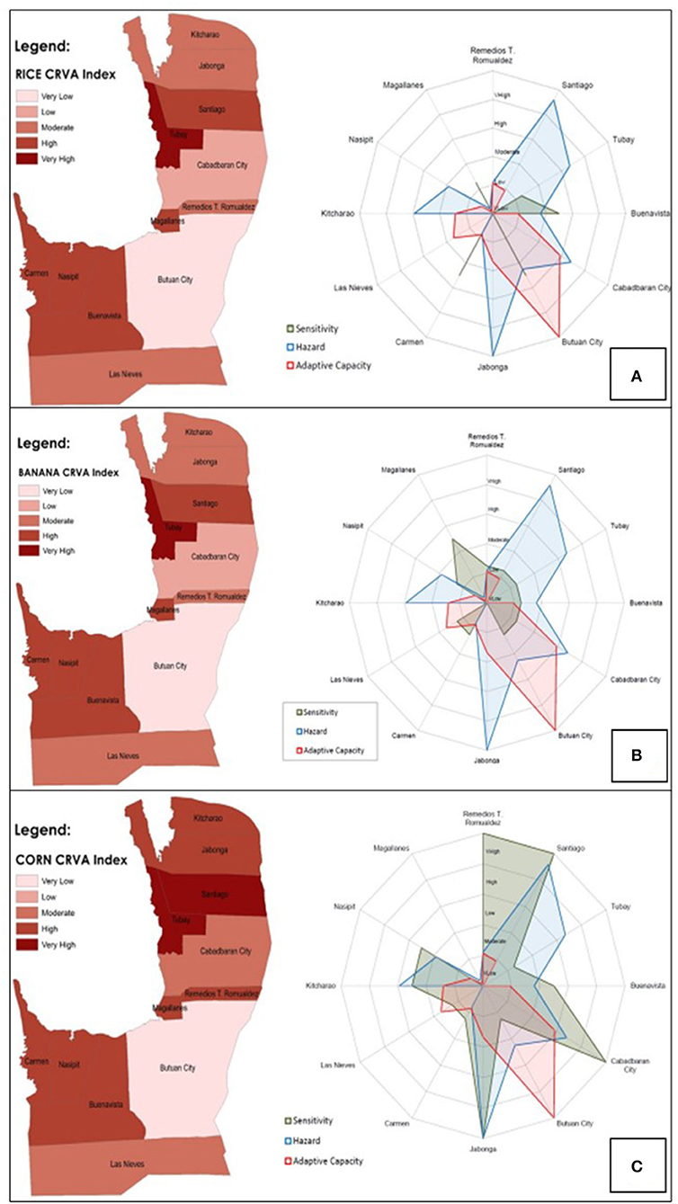
Figure 1. Climate Risk Vulnerability Index Map in Agusan del Norte for (A) rice; (B) banana; and (C) corn.
A twin climate risk vulnerability assessment index result was observed for rice and banana production. The twin index for the two crops is within the standard ranges. On the other hand, the CRVA model result for corn shows that there was a high vulnerability in most municipalities due to the divergence of high exposure to hazards, lower climate suitability of crop in the future, and low adaptive capacity. The radar graphs show the influence of the hazard, sensitivity, and adaptive capacity on the vulnerability status of the municipalities in Agusan del Norte.
The issues and the climate resilient agriculture (CRA) practices
The issues related to climate change in the Province of Agusan del Norte in Caraga Region are shown in Table 4. Across Agusan del Norte, rice, coconut, banana, abaca, and corn are the major crops grown. The agricultural development officers in the province identified these crops and associated the climate risks that adversely affected the production of these crops annually. The adverse effects of these climate risks led to reduced yield and income that would diminish the adaptive capacity of the farmers, especially during the flooding season. As shown in the table, flooding due to typhoons and continuous rain is the major challenge in the production of these crops across the province. Drought is also a climate risk to reckon with, particularly in the production of rice and corn. However, most of the climate change issues are the consequences of typhoons and flooding, in which pest and diseases, soil erosion, siltation and water logging are the resulting problems for the farmers. The agricultural development officers also identified the outcomes of experiencing the climate change issues and problems as destructive to the said crops that would eventually reduce the potential income from the crop yield. Typhoons could flatten the field and submerge the crops with a surge of water. Drought could damage as well through the emergence of pests and diseases as shown in the table. Additionally, floods could kill farm animals that become a source of dismay among the farmers. Toward these climate change impacts and issues, the CRA practices had been observed for farmers to learn some viable options to surmount the challenges of such devastating natural occurrences.
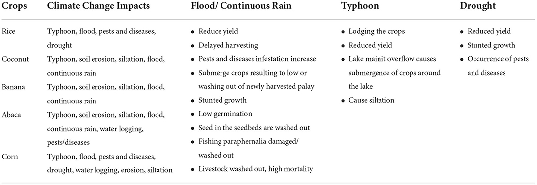
Table 4. List of issues and the CRA practices in response to climate change for the primary and secondary crops and livestock.
Climate resilient agriculture (CRA) practices: The case of Jabonga, Agusan del Norte
Climate change impacts can devastate tracts of croplands, which can put the welfare of a farming household at risk. In Jabonga, Agusan del Norte, Philippines, these impacts have been manifested in heavy rains and typhoons resulting to long flooding episodes and inundation for at least 2 weeks to 3 months in the maximum. In Chart C of Figure 1, corn is in great danger among the major crops to these climate change impacts, in which under such impacts corn is faced with high climate hazard and sensitivity potential. This also forms the major reason for the highlight of corn in this section. With the high potential for climate hazard and sensitivity to it, some of the corn farmers in the area have tried to adapt by adjusting their farming system to enable them to gain more income and resources to be used during the economically paralyzing flooding episode.
Climate hazard for CRA: Heavy rains and massive flooding
Jabonga is a municipality located near Lake Mainit, the fourth largest lake in the Philippines, and in Caraga Region where the pronounced climate pattern is characterized to be wet and very wet. The location of the Caraga Region in the Pacific Seaboard contributes to the unpredictable weather condition in Jabonga, Agusan del Norte. Every year, heavy rains and typhoons visit the area, bringing so much moisture and water to cause massive flooding and inundation of at least a meter high especially for the barangays of Colorado, Magsaysay and Libas, including the village in the center of Jabonga municipality. During this time of inundation, the water from the contiguous lake breaches into these barangays, challenging the draining out the flood waters. Fish species from the lake get into the flooded areas, but the agricultural fields are put under water for at least 2 weeks to 3 months at most every year. Boats (sometimes with motor) and rafts turn to become the means of transportation within the vicinities of the affected barangays. To salvage the lost opportunities during the time of inundation, the farmers resort to the practices of alternate monocropping and intercropping system for corn and squash, and of crop rotation for corn, rice and green corn. Those practices are presented here to be more preferrable than the conventional two-season monocropping for corn, due to added income and resources that can be used during the inundation period. The following are the observed practices and benefits from such cropping systems as a means of adapting to the dominant climate change impacts in the area.
Climate resilient agriculture (CRA) 1: Corn-squash/corn alternating monocropping and intercropping
Alternating monocropping and intercropping prior to the incidence of flood in the aforementioned barangays of Jabonga, Agusan del Norte may be a time-tested strategy to cope with climate change impacts of heavy rains and typhoons among the farmer adopters. With proper timing that is done by weather observation and listening to the weather advisories of the Philippine Atmospheric, Geophysical and Astronomical Space Administration (PAGASA) of the Department of Science and Technology (DOST), it ensures crop harvest capable to provide the farming households with income and resources to use during the flooding episode due to climate change. Thus, it is a production system that provides an economic buffer during times of inundation in the area.
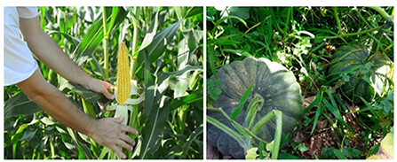
The practice allows the farmers to produce corn for two straight seasons (March–June and July–November) and squash (July–November) (Figure 2). Flood usually sets in during December–February, which is evaded by such production timing. No crop production occurs during the flood season, enabling the farming household to evade crop losses, produce income prior to flood, and set aside some amounts for saving. During the second cropping, corn is the market-oriented output, while the squash is not necessarily for sale. The squash is stored to be used as feeds for hogs. The hogs are raised until the households see them good for sale. To raise hogs during the flood season, the households use to transfer their hogs to elevated areas where other indigenous feed materials can be found such as pseudo stems of bananas. To get through the flood season, the households can sell the hogs to provide additional income for their daily needs. This practice is common in Barangay Colorado where the flood incidence can keep the area under water for 2–3 months.
Through the CRA practice, the farmers can adapt to flooding in the area for months. It helps the farming households minimize losses through calculated evasion of flood devastation. With this CRA practice, crop production continues to support the farmers' livelihood despite the disruption from flooding in the area. The practice of alternate monocropping and intercropping for corn and squash is adaptive for climate change impacts, which provides resilience to the farming households. The farmers can wait for the floods to drain out to engage in farming again. In Table 5, the said practice saves the farming households with the incremental net benefit of around Php4,500 or USD87 per hectare per year compared to the most common and considered as the conventional practice of monocropping. The estimated net increment from the CRA practice may be the least since the farming households can sell their hogs speculatively to earn more income. There may be additional expenses incurred due to the integration of squash in the area, but these additional expenses are recouped from the additional benefits with this CRA.
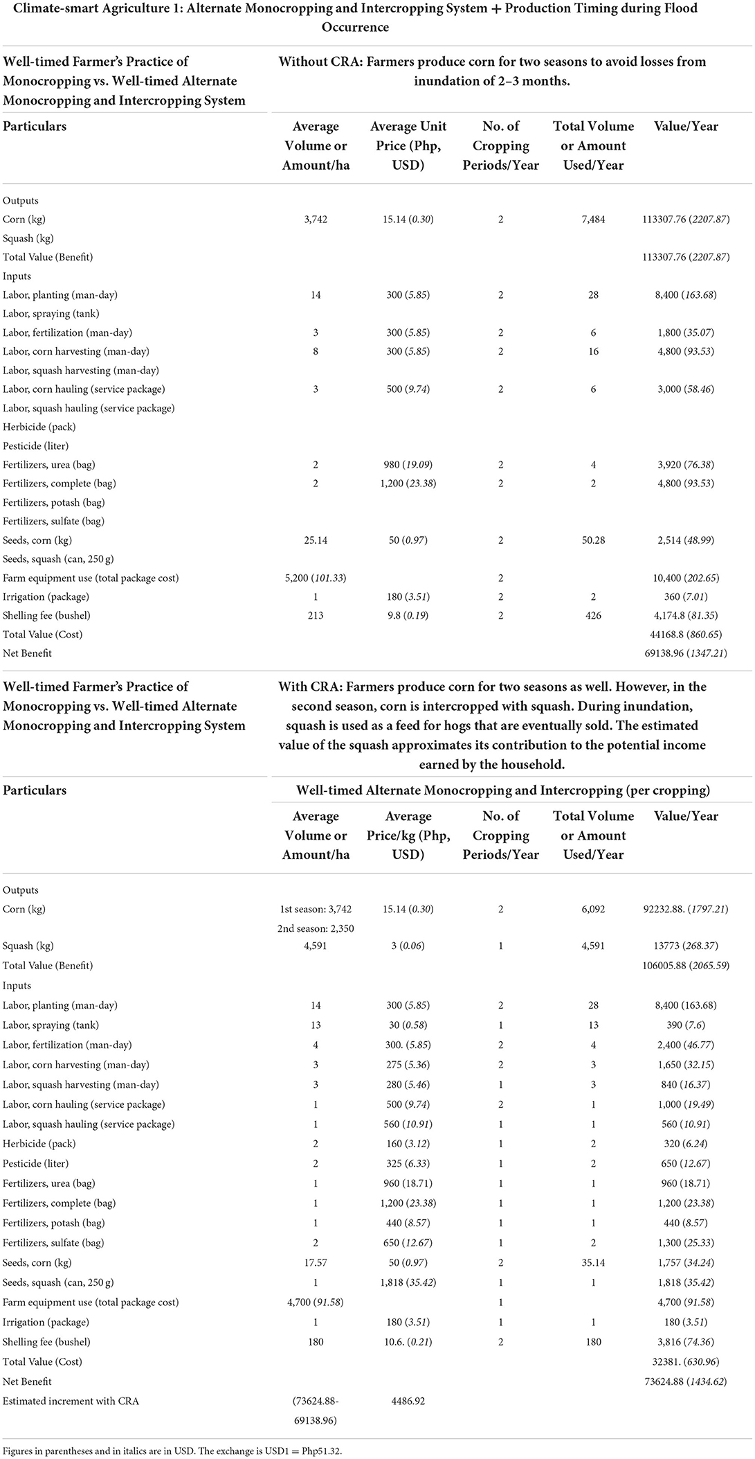
Table 5. Cost and benefit comparison of the well-timed pure monocropping and the well-timed alternate monocropping and intercropping.
Climate resilient agriculture (CRA) 2: Corn-rice-green corn crop rotation
Crop rotation is known to have beneficial effects on crops, especially since it promotes biodiversity conservation and protects the crops from pests and diseases as well. For some farmers in the affected areas of Jabonga, Agusan del Norte, the consequences of the risk associated with annual flooding are painful, which must be dealt with ingenuity. In this practice of crop rotation, the farmers can potentially earn better as shown in the succeeding (Table 6). With the flooding incidence seemingly occurring in the same period of the year, the farmers have learned to accept reality and have developed adaptations. The CRA practice of rotating crops and adjusting the production timing to suit the onset and end of flood in the area has been the practice of the farmers to survive the flood episode with minimal worry and anxiety. Observance of the flood patterns and crudely analyzing the flood damage have guided the farmers in configuring adaptations.
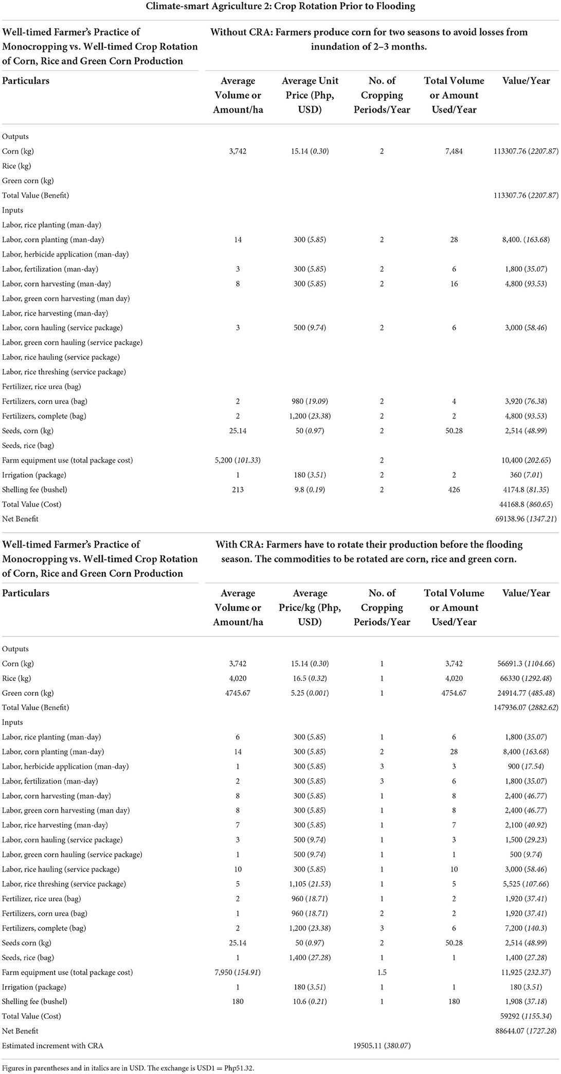
Table 6. Cost and benefit comparison of the well-timed pure monocropping and the well-timed crop rotation of corn, rice and green corn.
The CRA practice of crop rotation in this particular case is with a strong consideration of the proper timing of planting and harvesting. The first cropping is the production of corn grain, followed by the production of rice and the shorter green corn cropping (Figure 3). Green corn is opted as the last crop of this crop rotation strategy in anticipation of the start of rains and floods or inundation, the corn is cut short in production to grow only for 60–70 days for green corn production. This strategy allows the farmers to gain higher income than grain corn as the green corn sells higher at an earlier harvest time than the normal harvesting at 110 days after planting for grain corn. This allows the farming households to earn income from three sources: corn grain, rice and green corn. Table 5 specifies the potential benefits and costs per hectare per year. The conventional farming of corn (monocropping) is again compared to this CRA to evaluate the potential net benefit. As shown in Table 5, the expense items incurred in carrying out the entire cropping system of this CRA is increased, since rice and corn have different input requirements for their production. However, Table 5 shows that the net benefit or incremental benefit from this CRA is much larger than the earlier CRA. The superiority of the second CRA is shown here to generate an increment of around Php19,500 or USD380 per hectare per year (Table 5). The amount is considered a substantial buffer for the farming household to get through the flood incidence and begin farming again after the flood.
Conclusion
Climate change impacts have been already experienced across Caraga Region, particularly in the province of Agusan del Norte. The major crops grown in the province are adversely affected by these impacts, wherein their sensitivity and their degrees of climate hazards are estimated to be substantial. The climate mapping using the GIS and other tools have proved that the potential impacts of climate changes can be estimated to show the potential hazards and sensitivities of the crops grown in the area as well as the potential adaptive capacity of their agricultural producers. Furthermore, this study shows that the farmers can develop their adaptive capacities to mitigate the impacts of climate change. As shown in the earlier section, the farmers can confront adverse climate change impacts with their ingenuity. The farmers have made changes to their usual or common practices that enable them to earn additional income and resources to be used during the time when inundation in the area happens. This study has shown that the same changes can be implemented by the farmers of other crops to be able to withstand and adapt to the adverse impacts of climate change. The CRA practices highlighted here show that these are superior to the conventional farming practices even though there are additional cost items to confront.
On the other hand, the involvement of the local providers of technical support to agriculture enhancement are vital in strengthening the local capacity for Climate Resilient Agriculture (CRA) particularly in investment planning using climate risk maps. The local technologists are exposed to participatory climate risk mapping and assessing the cultural practices in farming and fishery to avoid the impacts of climate change. The maps of climate risks generated for the Province of Agusan del Norte serve as the basis for CRA investment planning. The maps on sensitivity, hazard, and adaptive capacity are useful inputs in investment planning for adaptation to climate change and creating climate-resilient agriculture. These maps guide farmers and the local technologists to improve the adaptive mechanisms or strategies of the farming communities to respond to climate-related hazards. Most municipalities across the study sites have a low adaptive capacity index. The results imply the need for the local government units to focus on improving their adaptive mechanisms by increasing their services and interventions to tackle climate-related pressures. Adaptive mechanisms to overcome the flood risks in Jabonga include corn-squash/corn crop rotation and corn-rice-green corn production rotation. The benefit of using adaptive approaches over the usual practice of crop production following the normal production calendar is not only on the economic aspects but also on the psychosocial side because farmers are given safety nets.
Data availability statement
The original contributions presented in the study are included in the article/supplementary material, further inquiries can be directed to the corresponding author/s.
Author contributions
RV responsible for the overall concept of the study. RB is responsible in working on the economics aspect of the study, in determining the cost-benefit analysis (CBA) including the sensitivity analysis. AA contributed to the geospatial assessment and mapping of the areas vulnerable to climate change. He is responsible for performing the climate risk and vulnerability analysis using Maxent for the climate risk and vulnerability mapping. All authors contributed to the article and approved the submitted version.
Funding
Department of Agriculture—Adaptation and Mitigation Initiatives in Agriculture (AMIA) Program.
Conflict of interest
The authors declare that the research was conducted in the absence of any commercial or financial relationships that could be construed as a potential conflict of interest.
Publisher's note
All claims expressed in this article are solely those of the authors and do not necessarily represent those of their affiliated organizations, or those of the publisher, the editors and the reviewers. Any product that may be evaluated in this article, or claim that may be made by its manufacturer, is not guaranteed or endorsed by the publisher.
References
Acosta-Michalik, L., and Espaldon, V. (2008). Assessing vulnerability of selected farming communities in the Philippines based on a behavioral model of agent's adaptation to global environmental change. Glob. Environ. Change 18, 554–563. doi: 10.1016/j.gloenvcha.2008.08.006
Aggarwal, P. K., Jarvis, A., Campbell, B. M., Zougmoré, R. B., Khatri-Chhetri, A., Vermeulen, S. J., et al. (2018). The climate-smart village approach: framework of an integrative strategy for scaling up adaptation options in agriculture. Ecol. Soc. 23, 14. doi: 10.5751/ES-09844-230114
Apdohan, A. G., Varela, R. P., and Balanay, R. M. (2021). Climate risk vulnerability assessment of the major crops in the province of Agusan del Norte, Philippines. Int. Arch. Photogr. Remote Sens. Spatial Inf. Sci. 46, 27–33. doi: 10.5194/isprs-archives-XLVI-4-W6-2021-27-2021
Aryal, J. P., Sapkota, T. B., Khurana, R., Khatri-Chhetri, A., Rahut, D. B., and Jat, M. L. (2020). Climate change and agriculture in South Asia: Adaptation options in smallholder production systems. Environ. Dev. Sustain. 22, 5045–5075. doi: 10.1007/s10668-019-00414-4
Balanay, R. M., Varela, R. P., and Halog, A. B. (2022). Circular economy for the sustainability of the wood-based industry: the case of Caraga Region, Philippines. Circ. Econ. Sustain. 2, 447–462. doi: 10.1016/B978-0-12-821664-4.00016-9
Barbier, E. B., and Hochard, J. P. (2018). Poverty, rural population distribution and climate change. Environ. Dev. Econ. 23, 234–256. doi: 10.1017/S1355770X17000353
Birthal, P. S., and Hazrana, J. (2019). Crop diversification and resilience of agriculture to climatic shocks: evidence from India. Agric. Syst. 173, 345–354. doi: 10.1016/j.agsy.2019.03.005
Escarcha, J. F., Lassa, J. A., and Zander, K. K. (2018). Livestock under climate change: a systematic review of impacts and adaptation. Climate 6, 54. doi: 10.3390/cli6030054
Grimberg, B. I., Ahmed, S., Ellis, C., Miller, Z., and Menalled, F. (2018). Climate change perceptions and observations of agricultural stakeholders in the Northern Great Plains. Sustainability 10, 1687. doi: 10.3390/su10051687
Hijmans, R. K., Cameron, J. L., Jones, P. G., and Jarvis, A. (2005). Very high resolution interpolated climate surfaces for global land areas. Int. J. Climatol. 25, 1965–1978. doi: 10.1002/joc.1276
Lin, B. B. (2011). Resilience in agriculture through crop diversification: adaptive management for environmental change. BioScience 61, 183–193. doi: 10.1525/bio.2011.61.3.4
Makate, C. (2020). Local institutions and indigenous knowledge in adoption and scaling of climate-smart agricultural innovations among sub-Saharan smallholder farmers. Int. J. Climate Change Strat. Manag. 12, 270–287. doi: 10.1108/IJCCSM-07-2018-0055
MGB-13 (2020). Mining Employment Data CY 2020. Available online at: https://www.mgbr13.ph/wp-content/uploads/2021/04/R13_Employment-Data.pdf (accessed June 2021).
National Nutrition Council (2021). Caraga Region History and Geography. Available online at: https://www.nnc.gov.ph/2-uncategorised/322-caraga-region-history-and-geography (accessed June 2021).
O'Donnell, M. S., and Ignizio, D. A. (2012). Bioclimatic predictors for supporting ecological applications in the coterminous united states. U.S. Geological Survey Data Series 691, 10.
Palao, L. M., Guerten, N., Martinez, A., Parker, L., Balanza, J. C., Leyte, J., et al. (2017). A Climate Risk Vulnerability Assessment for the Adaptation and Mitigation Initiative in Agriculture Program in the Philippines. Technical Report. Hanoi, Vietnam: Centro Internacional de Agricultura Tropical.
Perez, N., Rosegrant, M. W., and Inocencio, A. (2018). Philippine irrigation investment under climate change: scenarios, economic returns, and impacts on food security. DLSU Bus. Econ. Rev. 28, 121–146. Available online at: https://animorepository.dlsu.edu.ph/faculty_research/1376
Porter, J. J., Dessai, S., and Tompkins, E. L. (2014). What do we know about UK household adaptation to climate change? A systematic review. Clim. Change 127, 371–379. doi: 10.1007/s10584-014-1252-7
Stuecker, M. F., Tigchelaar, M., and Kantar, M. B. (2018). Climate variability impacts on rice production in the Philippines. PLoS ONE 13, e0201426. doi: 10.1371/journal.pone.0201426
Tigkas, D., Vangelis, H., and Tsakiris, G. (2020). Implementing crop evapotranspiration in RDI for farm-level drought evaluation and adaptation under climate change conditions. Water Resour Manag 34, 4329–4343. doi: 10.1007/s11269-020-02593-6
Tiongco, M. M. (2016). “Climate change adaptation and mitigation for the agriculture sector,” in Risk, Shocks, Building Resilience, 13. Available online at: https://pidswebs.pids.gov.ph
Tschakert, P., Dietrich, K., Tamminga, K., Prins, E., Shaffer, J., Liwenga, E., et al. (2014). Learning and envisioning under climatic uncertainty: an African experience. Environ. Plan. A 46, 1049–1068. doi: 10.1068/a46257
UNISDR (2013). Butuan City, Philippines. Retrieved from The United Nations Office for Disaster Risk Reduction. Available online at: https://www.unisdr.org/2013/sasakawa/documents/nominees/ButuanCity.pdf (accessed June 2021).
Varela, R. P., Balanay, R. M., and Halog, A. (2021). “Changing the way we produce food: an overview of the current agricultural food production industry and worldwide trends for sustainable production,” in Climate Change and Resilient Food Systems, eds V. K. H. Mallappa, and M. Shirur (Springer, Singapore), 205–217. doi: 10.1007/978-981-33-4538-6_7
Keywords: climate change, climate-resilient agriculture, mitigation, vulnerability mapping, adaptive capacity, climate risk
Citation: Varela RP, Apdohan AG and Balanay RM (2022) Climate resilient agriculture and enhancing food production: Field experience from Agusan del Norte, Caraga Region, Philippines. Front. Sustain. Food Syst. 6:974789. doi: 10.3389/fsufs.2022.974789
Received: 21 June 2022; Accepted: 25 July 2022;
Published: 18 August 2022.
Edited by:
Liming Ye, Ghent University, BelgiumReviewed by:
Salisu Lawal Hallru, Federal College of Education Kano, NigeriaSeyi Olalekan Olawuyi, Ladoke Akintola University of Technology, Nigeria
Copyright © 2022 Varela, Apdohan and Balanay. This is an open-access article distributed under the terms of the Creative Commons Attribution License (CC BY). The use, distribution or reproduction in other forums is permitted, provided the original author(s) and the copyright owner(s) are credited and that the original publication in this journal is cited, in accordance with accepted academic practice. No use, distribution or reproduction is permitted which does not comply with these terms.
*Correspondence: Rowena P. Varela, cnB2YXJlbGFAY2Fyc3UuZWR1LnBo
 Rowena P. Varela
 Arnold G. Apdohan
 Raquel M. Balanay