 Heping Hou
- 1Post-doctoral Research Station of Landscape Architecture, Henan Agricultural University, Zhengzhou, China
- 2College of Forestry, Henan Agricultural University, Zhengzhou, China
- 3School of Resources and Environment, Henan Agricultural University, Zhengzhou, China
Heritage trees have important historical, landscape, and ecological value. Exploring the spatial distribution pattern of heritage trees is of great importance to the construction of ecological civilization and the connotation of regional history and culture. This paper took 5,216 heritage trees in Luoyang, an ancient capital of China, as the research object and used geospatial analysis methods and a geographically weighted regression model to analyze the differences and driving forces of the spatial distribution of heritage trees. Results show that 1) the heritage trees in Luoyang were primarily Gleditsia sinensis, Sophora japonica, and Platycladus orientalis, and more than half of these trees were under 300 years old; 2) the high-density area formed a distribution pattern of “three cores, one ring, and two belts,” and the distribution of heritage trees had a positive spatial autocorrelation; 3) different driving factors in different regions had complex influences on the spatial distribution of heritage trees, and the order of influence was as follows: area of forest and orchard land > elevation > number of POIs (points of interest) > distance to the nearest river > slope > number of immovable relics. The results could provide a comprehensive understanding of the spatial distribution of heritage trees to protect the ecological function of heritage trees and mine the cultural value of heritage trees.
1 Introduction
Heritage trees refer to trees with important ecological, historical, and cultural values preserved in history, and they are non-renewable resources formed by the combined effects of time and geography (Nolan et al., 2020). As an important part of the ecosystem, heritage trees provide not only habitats for animals and plants, but also production and living materials for human beings (Wu et al., 2020; Gilhen-Baker et al., 2022). Moreover, some heritage trees retain valuable genes of endangered species; therefore, they are of great significance to biodiversity conservation (Spooner and Shoard, 2016). Meanwhile, heritage trees are the activation records of local ancient geography and climate change, (Lindenmayer et al., 2012; Huang et al., 2020; Nolan et al., 2020). Therefore, characteristics such as species, age, and location of heritage trees can provide important information for historical geographic studies (Atindehou et al., 2022). Heritage trees are also important urban landscapes. They not only beautify and improve the urban ecology through their rhizomes, trunks, flowers, and leaves (Lindenmayer, 2017), but also endow with certain cultural meanings, for example, Cupressus funebris and Ginkgo biloba trees were used as the materialization expression and inheritance of customs and cultural beliefs (Blicharska and Mikusinski, 2014; Liu et al., 2020). During industrialization and urbanization, historical cities, where heritage trees can be primarily found, had undergone major developmental transformation and landscape reconstruction, which has had a remarkable effect on the original living environment and distribution of heritage trees (Lindenmayer et al., 2012; Chen and Hua, 2017; Huang et al., 2022). Therefore, the protection of heritage trees is an urgent issue faced by historical cities. Exploring the spatial pattern of the distribution of heritage trees in historical cities and their influencing factors based on the “human–land relationship” in geography will provide comprehensive understanding of heritage trees and important reference significance for protecting heritage trees, thereby enhancing the cultural connotation of historical cities and developing tourism related to historical culture.
Scholars have conducted research on heritage trees from various topics. First, the definition and evaluation criteria for heritage trees vary worldwide (Spies, 2004). The United States and Europe have considered the size of heritage trees such as canopy and height, whereas China has emphasized the age and historical and cultural connotations of heritage trees (Lai et al., 2019). Second, despite different definitions of heritage trees, investigation and monitoring method have certain similarities; thus, sophisticated and intelligent techniques, including unmanned aerial vehicles, have been widely used (Singh et al., 2015; Qiu et al., 2018). Finally, biologists and foresters primarily aimed to explore rejuvenation and pest control; thus, they conducted research on specific tree species (Zhang et al., 2013; Takács et al., 2020). Some studies have indicated that heritage trees are closely associated with daily needs of local residents and their cultures and beliefs, and the direct or indirect historical and cultural value of heritage trees has been effectively excavated (Jordan et al., 2021; Cannon et al., 2022). Economic valuation of heritage trees provided an innovative perspective and dimension to quantify their value (Lin et al., 2020; Wyla & Ycc, 2022). With the improvement of economic development and the enhancement of heritage tree protection, relevant regulations and practical explorations of heritage tree protection have gradually emerged based on local conditions (Lindenmayer et al., 2014). In recent years, with the continuous investigation of heritage trees, the heritage tree information system has been gradually established and improved; therefore, a growing body of work has been carried out on reporting the spatial distribution of heritage trees. Based on different dimensions, the current studies can be roughly divided into three major categories: 1) With regard to the spatial distribution of heritage trees, existing research methods have gradually changed from simple mathematical statistics to spatial econometric analysis, but most studies have remained in the quantity statistics of heritage trees in different regions and administrative units (Asanok et al., 2021; Liu et al., 2022). Few in-depth analyses of the patterns, characteristics, and trends of the spatial distribution of heritage trees have been conducted, but such analyses are not conducive to the resource integration and planning of heritage trees. 2) The influencing factors of the distribution of heritage trees can be divided into two categories: natural and human factors. The former primarily includes latitude and longitude, topography (e.g., elevation, and slope) (Lindenmayer and Laurance, 2016; Wan et al., 2020), and climate (e.g., average annual temperature and average annual precipitation) (Liu et al., 2020; Li and Zhang, 2021). The latter can be measured by human activity intensity and urban development, such as population density and GDP per capita. Heritage trees are closely associated with historical figures, events, and buildings, which are an important part of local culture. In particular, some ancient capitals have glorious and profound historical culture, which are indispensable influencing factors of the spatial distribution of heritage trees (Badgujar et al., 2014; Ray et al., 2014). However, less concern was given to these important factors. 3) Regarding the relationship between influencing factors and the spatial distribution of heritage trees, most of the existing studies were carried out by qualitative induction or simple quantitative regression analysis (Zhang et al., 2017; Liu et al., 2019). Nevertheless, trees and their communities have certain spatial autocorrelation and heterogeneity (Wang et al., 2021). Therefore, various influencing factors of the distribution of heritage trees are spatially unbalanced. A geographically weighted regression (GWR) model is a typical local regression model, and the regression coefficient of its independent variable is not a global uniform value; it changes with the spatial position, indicating that different factors have different effects on the dependent variable because of different locations (Osborne and Suárez-Seoane, 2002; Foody, 2004). Therefore, GWR is suitable for the research of the influencing factors and their degree of influence on heritage trees distribution. GWR has been widely applied in various disciplines, including social economy, forestry, and ecological activities (Austin, 2007; Chen et al., 2021), but it is rarely seen in the research on the influencing factors of heritage tree distribution.
From the perspective of “human–land relationship”, this paper focused on the multiple characteristics of heritage trees in nature, humanities, and geography. Taking 5,216 heritage trees in the ancient capital of Luoyang in central China as the research object, quantitative analysis was performed on their species composition and spatial distribution, and a GWR model was used to reveal the degree of influence and spatial variation of natural and human factors influencing the distribution of heritage trees. The exploration of the spatial patterns and influencing factors of the distribution of heritage trees in Luoyang will provide theoretical reference for scientifically protecting the ecological and cultural functions and effectively excavating the social and economic value of heritage trees.
2 Data and method
2.1 Study area
Luoyang covers 15,230 km2 area, and it is located in the West of Henan Province in central China (34°32′–34°45′N, 112°16′–112°37′E). Luoyang has a complex and diverse topography. The terrain is high in the West and low in the East. It belongs to the warm temperate continental monsoon climate with four distinctive seasons, and it is rich in vegetation resources. The city covers a forest area of 6,929.65 km2, with 45.5% forest coverage rate. Luoyang is a famous historical city, and it is one of the four ancient capitals of China (the other three are Xi’an, Beijing, and Nanjing), with more than 5,000 years of civilization history, 4,000 years of urban history, and 1,500 years of capital history. In history, 13 ancient Chinese dynasties established their capitals in Luoyang. Luoyang has rich historical cultural landscapes, and it has five capital ruins and three world cultural heritage sites. It is a national famous historical cultural city and an excellent tourism city. Heritage trees were widely distributed in Luoyang, and they symbolize the long history of the ancient capital Luoyang.
In recent decades, Luoyang has witnessed rapid economic development as an important industrial base and tourism city in central China. In 2020, Luoyang’s GDP was 544.71 billion yuan, ranking first among non-provincial capital cities in central China, with a population of 7.06 million. And an urbanization rate of 65.01%. In the past few decades, the urban population of Luoyang has increased from 19% in 1990 to 64% in 2020, experiencing rapid urbanization process. At present, Luoyang is a major city in the Yellow River Basin and a sub-center city of the Central Plains Urban Agglomeration. It has 15 administrative districts, which are divided into central urban areas (Laocheng, Chanhe, Luolong, Jianxi, and Xigong), suburbs (Yiyang, Xin’an, Mengjin, Yanshi, Jili, and Yichuan), and outer suburbs (Luoning, Luanchuan, Songxian, and Ruyang; Figure 1). Rapid urbanization has eroded the living environment of heritage trees and caused damage to the historical culture and urban landscape of Luoyang. Therefore, taking the heritage trees of Luoyang as the research object and excavating the degree and difference of the influence of natural and cultural factors on heritage trees is important for the protection of historical heritage and urban landscape of Luoyang.
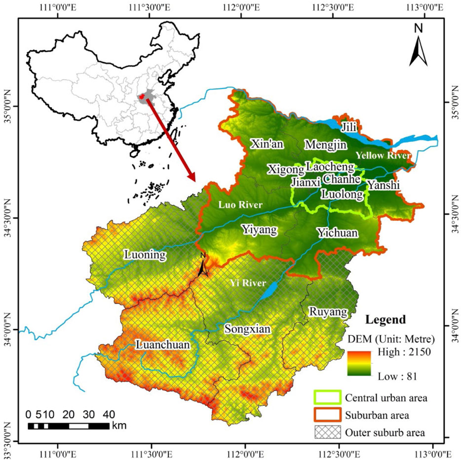
FIGURE 1. Location of luoyang in central China.
2.2 Data sources
The data of heritage trees in Luoyang were obtained from the compilation of “Henan Ancient and Famous Trees” (Wang et al., 2010). Then, species, coordinates, tree age, and other information of heritage trees were collated and supplied in accordance with Cloud Platform for Forest Genetic Resources Information of Henan Province, in which the data were collected on the basis of provincial forest field surveys from 2016 to 2020 in Henan Province. The investigations of ancient trees were conducted in accordance with the Chinese government’s national-level document “Technical Guidelines for the Document Establishment of a General Survey of National Ancient and Famous Trees” in 2001, which has been widely used in China (Li and Zhang, 2021). First, based on the coordinates and location description, heritage trees in Luoyang were selected as the study object. Furthermore, botanical names, taxonomic classifications, and species name of all heritage trees in Luoyang were identified following the Flora of China. For example, some heritage trees were recorded as Huai in Chinese; then based on their photos and morphological descriptions, they were corrected to Guohuai, which are Sophora japonica in terminology. Finally, four ancient trees were excluded because their ages were less than 100 years old. The slope and elevation data were obtained from the 30 m resolution data of the Digital Elevation Model (DEM) provided by Resource and Environment Science and Data Center in Chinese Academy of Science. River and land use data were extracted from the results of the annual survey of land use changes in Luoyang in 2020. The data of immovable relics were downloaded from the “Immovable Cultural Relics Data System” provided by Luoyang Municipal Bureau of Cultural Relics. The POI data reflects the spatial pattern of human–land relationship through the basic spatial information. Meanwhile, the POI data obtained through a unified platform, not only has the advantages of wide coverage, easy collection and centralized processing in quantities, but also can avoid data deviation caused by inconsistent data update time and recording standards. The POI data in December 2019 in Luoyang City were obtained through the application program interface embedded in the AutoNavi map navigation platform, and 291,539 POIs were obtained through deduplication and spatial registration. Each POI data included the name, longitude and latitude, address, type, telephone, administrative region and other information.
2.3 Methods
A geographic database of heritage trees in Luoyang was established using ArcGIS 10.2. The nearest neighbor index (NNI), kernel density analysis method, and exploratory spatial data analysis (ESDA) were used to study the distribution characteristics of heritage trees in Luoyang at different geographical scales. In addition, a GWR method was used to analyze the influencing factors of the spatial distribution of heritage trees.
2.3.1 Nearest neighbor index
The NNI method was used to investigate the spatial distribution types of heritage trees in Luoyang. In general, NNI was defined as the ratio of the actual nearest neighbor distance to the theoretical nearest neighbor distance (Lin and Chen, 2021), which was calculated as follows:
where dij refers to the actual distance between heritage trees; A refers to the total area of Luoyang, and n refers to the number of heritage trees. NNI>1 indicates that the heritage tree is uniformly distributed; NNI = 1 indicates random distribution, and NNI<1 indicates agglomerative distribution. The smaller the NNI value, the more agglomerated heritage trees were distributed.
2.3.2 Kernel density estimation
Kernel density estimation indicated the specific area where heritage trees gather and disperse (Sheather, 2004), which was calculated as follows:
where f(x) refers to the kernel density value of heritage trees; n refers to the number of heritage trees; h refers to the bandwidth, which is the radius of the circle; K refers to the spatial weight function; x–xi refers to the estimated distance between two heritage trees.
2.3.3 Exploratory spatial data analysis
ESDA was used to analyze the spatial dependence and correlation of heritage trees. Global Moran’s I index can be used to observe the spatial correlation of heritage trees in the whole study area based on their spatial locations. Local correlation index Getis-Ord Gi* distinguished the spatial differentiation between cold and hot spots by detecting high-value and low-value agglomeration areas (Getis & Ord, 1992). The specific calculation formulas were as follows:
where n refers to the number of heritage trees; Xi and Xj refer to the heritage tree of the i-th and j-th units, respectively; X̅ is the mean value of heritage trees; Wij is the spatial weight matrix, and S0 is the sum of spatial weight matrices. E(Gi*) and Var(Gi*) are the variance and expectation of Gi*, respectively. The value of Moran’s I ranges from −1 to 1. Moran’s I > 0 indicates a positive spatial correlation, whereas Moran’s I < 0 indicates a negative spatial correlation. If the index is close to 0, then no spatial correlation is observed. The statistical significance of Gi* (d) can be tested by standardized Z value. When Z > 0, the higher the Z value, the denser the aggregation of high values (hot spots); When Z < 0, the lower the Z value, the denser the aggregation of low value (cold spot).
2.3.4 Geographically weighted regression
The GWR model provided each spatial position with a regression coefficient, which was unattainable using the ordinary least squares (OLS) model. Regression analysis performed using the GWR model was used to select the center point and standard distance in each selected area to determine whether different regression coefficients can be acquired (Wang et al., 2021). Hence, the regression coefficient was not calculated using a constant value. Instead, the position function for each geographic location i was used to calculate the regression coefficient. Therefore, the spatial variation of influencing factors in different locations can be explored by applying GWR, and the results were more reliable. The Akaike information criterion (AIC) method was based on the concept of entropy and can obtain. Thus, in this study, the AIC was used to optimize the bandwidth (Chen et al., 2021). The GWR model formula was presented as follows:
where yi refers to the (n × 1)-dimensional explained variable; xik refers to the (n × k)-dimensional explanatory variable matrix; βk (ui,vi) refers to the regression coefficient of factor k at regression point i; n refers to the number of independent variables; (ui,vi) refers to the longitude and latitude coordinates of the ith observation point, and εi is the residual.
3 Results
3.1 Differential characteristics of heritage trees
3.1.1 Species characteristics of heritage trees
A total of 5,216 heritage trees were identified in Luoyang, belonging to 97 species, 70 genera, and 39 families. The number of species varied greatly. As shown in Table 1, the number of Gleditsia sinensis was the largest, with a total of 2,225 plants, accounting for 42.6% of the total, which was primarily distributed in Xin’an and Yichuan, followed by 940 S. japonicas and 423 Platycladus orientalis, accounting for 18% and 8.1%, respectively. These three dominant species of heritage trees in Luoyang had unique biological characteristics and economic and cultural values. On the one hand, these three species were all endemic to China. They were physiologically resistant to drought and frost without strict soil requirements. They had good shape, long lifespan, and fruiting period of hundreds of years. To date, as excellent greening trees, they were still found for urban landscape in China. On the other hand, their wood was hard and straight, and their leaves, flowers, fruits, seeds, skins, and thorns were important materials for traditional Chinese medicine and food. For example, the saponin horn produced by G. sinensis was the primary raw material for washing clothes and hair in the agricultural era, and the leaves, flowers, and seeds were edible and medicinal.
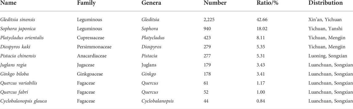
TABLE 1. Statistics of the top 10 heritage tree species in Luoyang.
According to the “Technical Guidelines for the Document Establishment of a General Survey of National Ancient and Famous Trees,” the heritage trees in Luoyang were divided into three categories based on their age (Table 2), namely, type Ⅰ (age ≥500a), type Ⅱ (300a ≤ age <500a), and type Ⅲ (age <300a). Among these categories, the number of heritage trees for type Ⅰ, Ⅱ, and Ⅲ was 723, 1,318, and 2,953, accounting for 13.86%, 25.27%, and 56.62%, respectively. The age of heritage in Luoyang presented a pyramid structure. With the increase of age, the number of heritage trees gradually decreased, and young trees had an absolute advantage. Among the dominant heritage trees, G. sinensis accounted for a larger proportion in type Ⅱ and Ⅲ, with an average age of only 215.67a, whereas G. biloba (with an average age of 1,052.74a), P. orientalis (with an average age of 463.21a), and S. japonica (with an average age of 408.77a) primarily belonged to type Ⅰ because of their religious significance and folk beliefs.
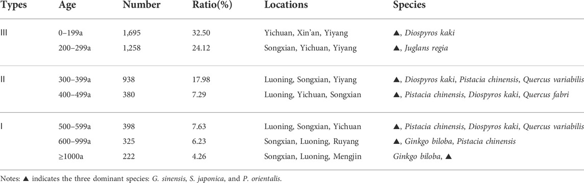
TABLE 2. Categories of heritage trees according to their age.
3.1.2 Spatial characteristics of heritage trees
1) Regional differences in the distribution of heritage trees
Significant regional differences were found in the distribution of heritage trees (Figure 2). As the political, economic, and cultural center of Luoyang, the central urban area had a large population and high urbanization, but only 176 heritage trees were identified, accounting for 3.37%, with a low density of 0.22 trees/km2. Suburbs had the most heritage trees (2,929), accounting for 56.15%, and the density was 0.55 trees/km2. Suburbs were located along the Yellow River, Yi River, and Luo River, and they had a flat terrain and numerous national and provincial cultural relics, making it a gathering area of heritage trees in Luoyang. A total of 2,111 heritage trees were found in outer suburbs, accounting for 40.47%, and the density was 0.23 trees/km2. The valley and hills in outer suburbs were alternately distributed, and heritage trees were relatively scattered, which were primarily distributed in bands along the river valleys.
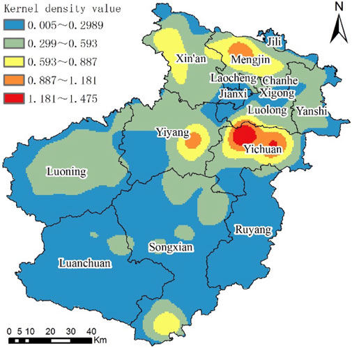
FIGURE 2. Kernel density estimation of heritage trees.
The number of heritage trees in each county varied greatly (Table 3). Songxian, Yichuan, Luoning, Xin’an, Yiyang, and Mengjin were the top six counties with the highest number of heritage trees, ranging from 514 to 839, and the proportion exceeds 9.85%. The number of heritage trees in the central urban areas of Chanhe, Jianxi, Xigong, and Laocheng was less, ranging from 0 to 21. Therefore, the order of the number and density of heritage trees was inconsistent because of the large area difference among counties. Chanhe only had 21 heritage trees, but its density was the highest (0.83 trees/km2) because of its small area. Songxian, Luoning, Luanchuan, and Ruyang had more heritage trees but less density. Among these counties, Songxian had the most existing heritage trees, but the density was only 0.28 trees/km2. Mengjin and Yichuan had advantages in the number and density of heritage trees.
2) Spatial agglomeration characteristics of heritage trees
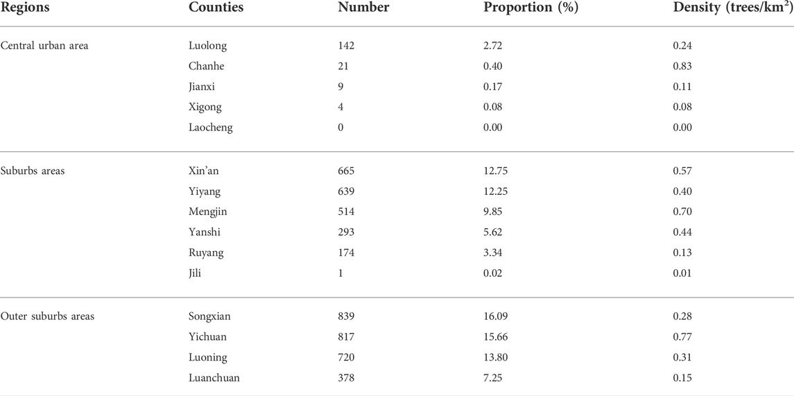
TABLE 3. Statistics of heritage trees in each county.
ArcGIS 10.2 was used to calculate the NNI of 5,216 heritage trees. After standardized statistics, the Z value was −103.74; the p value of the significance test was 0.00, and the confidence level was 99%, which indicated that the spatial distribution of heritage trees in Luoyang tended to agglomerate. The spatial aggregation characteristics of heritage trees were further analyzed by kernel density, and the study area was divided into the lowest density area, lower density area, medium-density area, higher-density area, and highest-density area by equal interval grading based on the kernel density value. The distribution of heritage trees in Luoyang presentd the aggregation characteristics of “three cores, one ring and two belts” (Figure 2). “Three cores” refered to the three typical highest density and higher density agglomeration areas along the Yi River in the north of Yichuan, along the Luo River in the southeast of Yiyang, and along the Yellow River in the middle-west of Mengjin Medium-density areas were distributed around the “three cores” in the Daimei Mountain area in the west of Xin’an and the Funiu Mountains in the south of Songxian, forming two relatively scattered agglomeration areas. “One ring” refered to the ring-shaped lower density agglomeration area formed around the central urban area of the Northern Luo River. The “two belts” refered to the two lower density areas formed along the Luo River in the Southwest and along the Yi River in the Southeast. The lower density area along the Luo River was larger, and the lower density area of the Yi River was composed of scattered dots. Moreover, the nuclear density value was in the range of 0.30–0.59 trees/km2. The lowest density area was widely distributed in Ruyang, Luanchuan, and Songxian in the south and central urban area in the North, with the lowest value of 0.0046 trees/km2.
3) Spatial correlation characteristics of heritage trees
The estimated value of Global Moran’s I of heritage trees in Luoyang was 0.0892 > 0, and the Z value of normal statistics was 16.17, which passed the 99% confidence test. This result showed that the distribution of heritage trees in Luoyang had positive spatial autocorrelation. 1,374 village-level units where the heritage trees were located were identified by cold and hot spots, and the local correlation index Getis-Ord Gi* was calculated (Figure 3). Based on the Z value, four types of areas were divided into four categories, namely, cold spot (−2.244 to −1.960), sub-cold spot (−1.959 to 0), sub-hot spot (0.001–1.960), and hot spot (1.961–10.567). With regard to the number of villages, the hot spots and sub-hot spots, where the villages and their neighborhoods had more heritage trees, only contained 91 and 390 villages, respectively, whereas the number of sub-cold spots and cold spots, including villages and their surrounding villages with little heritage trees, were 876 and 17, respectively. With regard to regional distribution, hotspots and sub-hotspots were relatively concentrated in suburbs and primarily located in Yichuan, Yiyang, Mengjin, and the West of Xin’an; while the hotspot and sub-hotspots scattered in the outer suburbs. The distribution range of sub-cold spot villages were relatively wide, meanwhile, some were concentrated in the urban area and the surrounding suburbs. Cold spots included 11 villages gathering around the county seat of Xin’an and six villages near Luoyang Beijiao Airport. The distribution of cold and hot spots of heritage trees in Luoyang was uneven, the hot spot area and cold spot area were small but concentrated, whereas the sub-hot spot area and sub-cold spot area were large but scattered.
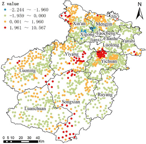
FIGURE 3. Classification of cold and hot spots for villages with heritage trees.
3.2 Driving force of the spatial distribution of heritage trees
3.2.1 Geographically weighted regression model
The spatial distribution difference of heritage trees in Luoyang results from the long-term comprehensive effect of local environment and culture. Based on previous studies and the actual situation of Luoyang, six quantifiable and accessible factors were selected from the two aspects of natural environment (elevation, slope, and water source) and human activities (historical and cultural aspects, land use, and economic intensity), and then taking 1,374 villages with heritage as statistical units, a GWR model was built to explore the driving force of the distribution of heritage trees. The interpretation and visualization of driving factors were shown in Table 4 and Figure 4.
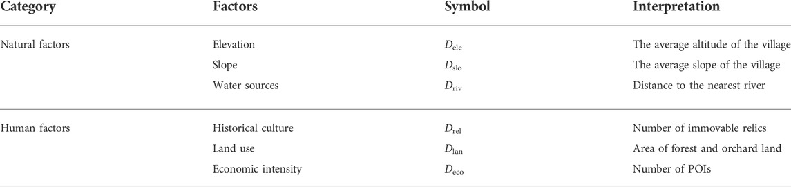
TABLE 4. Driving factors and their interpretation.
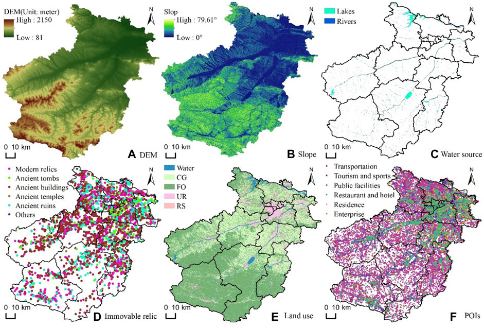
FIGURE 4. Visualization of driving factors: (A) DEM; (B) Slope; (C) Water source; (D) Immovable relic; (E) Land use; (F) POIs.
A GWR model was constructed to analyze the driving force of the distribution of Luoyang heritage trees, and the regression coefficients of the selected driving factors were calculated (Table 5). The positive (negative) of the regression coefficient of each factor indicated the positive (negative) correlation between the distribution of Luoyang heritage trees and the driving factor. Greater absolute value of the regression coefficient indicated more significant influence of the factor on the distribution of Luoyang heritage trees. The maximum and minimum values of the regression coefficients of all driving factors were different, indicating that the driving factors of the spatial distribution of heritage trees in different regions were different (Figure 5). Based on the mean values of the regression coefficient, the results were obtained as follows: elevation, slope, and the area of forest and orchard land were positively correlated, whereas distance to the nearest river and number of POIs were negatively correlated; the relationship between the number of immovable relics and the spatial distribution of heritage trees was relatively weak. The degree of influence of the six factors on the distribution of heritage trees was in the following order according to the absolute value of their regression coefficients in the GWR model: area of forest and orchard > elevation > number of POIs > distance to the nearest river > slope > number of immovable relics.
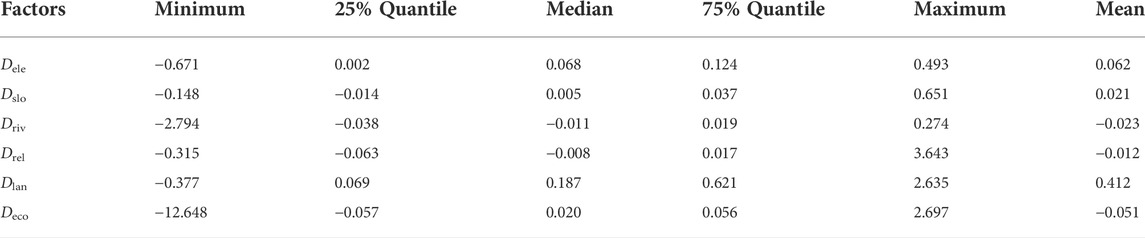
TABLE 5. Statistics of regression parameters of the GWR model.
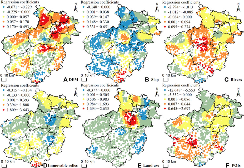
FIGURE 5. Spatial distribution of regression coefficients of driving factors in the GWR model: (A) DEM; (B) Slope; (C) Rivers; (D) Immovable relic; (E) Land use; (F) POIs.
3.2.2 Natural factors
1) Elevation
Heritage trees in Luoyang were distributed in the areas with elevation between 91 and 1,603 m, of which the areas with elevations of 200–500 m had the largest number of heritage trees (2,913), accounting for more than 40% of the total, followed by the areas with elevation ranging from 500 to 1,000 m (1,445 heritage trees), accounting for 27.70%. In flat areas with elevation of 93–200 m and mountainous areas with elevation of 1,000–1,603 m, the number of heritage trees decreased sharply, accounting for only 9.82% and 6.63%, respectively. The regression coefficient of Dele in the GWR model ranged from −0.671 to 0.493, with a mean value of 0.062, which indicated that the influence of elevation on the spatial distribution of heritage trees was heterogeneous. The areas with high regression coefficient were primarily located in the plain area in the North and the valleys of the Yi River and Luo River in the South, which were concentrated in the central urban area, Mengjin, and Xin’an. In mountainous and hilly areas of Yiyang, Luoning, and Songxian, the regression coefficients of Dele were negative, and the elevation was negatively correlated with the distribution of heritage trees. The minimum value of the regression coefficients were primarily concentrated in the mountainous area in the South of Songxian. More than 80% of the heritage trees in Luoyang were concentrated in hilly land because of the crisscross of river valleys, appropriate temperature, and convenient water source. The complex terrain was conducive to reducing the intensity of human activities and providing necessary conditions for the growth and protection of heritage trees.
2) Slop
The number of heritage trees in Luoyang increased initially and then decreased with the increase of slope (Figure 6). The regression coefficients of Dslo ranged from −0.148 to 0.651. The mean value of 0.021 and standard deviation of 0.069 indicated that the explanatory power of the slope to the distribution of heritage trees was weak, and the elasticity of the regression coefficients was small. The number of heritage trees in the areas with a slope ranging from 5° to 15° was the largest, accounting for more than 39.90%, followed by the areas with a slope ranging from 2° to 5°, accounting for 20.21%. The number of heritage trees in the area with a slope of >15° decreased sharply, whereas that in areas with steep slopes (35°–55°) only accounted for 3.60%.
3) Water sources
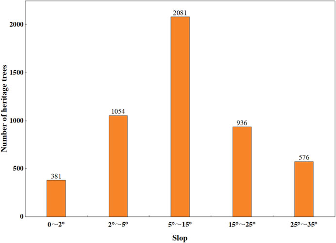
FIGURE 6. Number of heritage trees under different slopes.
Heritage trees in Luoyang had a near-water distribution, and they were primarily distributed along the banks of the Yellow River, Luo River, and Yi River. The regression coefficient of Driv ranged from −2.794 to 0.274, with a mean value of −0.023 and standard deviation of 0.149. The number of heritage trees in Luoyang gradually decreased with the increase of the distance to the river and showed a certain spatial heterogeneity. Heritage trees in areas less than 1.5 km away from the nearest river were the most concentrated, accounting for 63.48%. If the distance to the nearest river was greater than 1.5 km, then the number of heritage trees decreased significantly (Figure 7). In the northeastern of Luoyang, the river network was dense, and the terrain was flat. Historically, the rivers in this area were prone to floods during the flood season. Therefore, the distribution of heritage trees had a negative correlation with the distance to the river. The Southern region was the upper reaches of the Luo River and Yi River. The water volume of the rivers was small and unstable, and it was highly dependent on seasonal precipitation. Consequently, heritage trees in the Southern region were mostly distributed along the river to ensure sufficient water source.
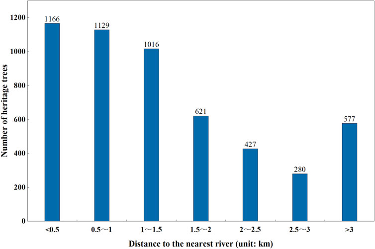
FIGURE 7. Number of heritage trees in different distances to the nearest river.
3.2.3 Human factors
1) Historical culture
As a special ecological resource, heritage trees have a certain spatial relationship with relics, and the relationship between the two has an important effect on the protecting heritage trees and excavating the value of them. Using the spatial analysis function of ArcGIS 10.2, Drel was calculated in the range of 0–8.42 km. A total of 4,121 heritage trees were primarily distributed within 2 km from the nearest river, accounting for 79.01%. The proportions of heritage trees in other three distances of 2–4 km, 4–6 km, and >6 km were 14.32%, 5.02%, and 1.65%, respectively. The GWR coefficient of Drel (–0.315–3.643) and its mean value (−0.012) indicated that more negative relationship units were found than positive ones, indicating spatial heterogeneity. The river valleys and plains in Luoyang were concentrated areas of immovable relics. The number of immovable relics and the number of heritage trees had a negative spatial relationship because of frequent human activities, low vegetation coverage, and less stable environments suitable for the growth of heritage trees in these areas. The units with a positive relationship between immovable relics and heritage trees were primarily concentrated in the northeast of Luoyang, and these areas belonged to the mountainous area of Mangshan with many ancient ruins and tombs. Heritage trees, such as P. orientalis, were the important component of the ancient ruins and tombs to indicates longevity and permanence. In areas with complex terrain such as mountains and hills, immovable relics were scattered, and the distribution of heritage trees is “close to relics”.
2) Land use
Based on the suitability of the growth of heritage trees, the land in Luoyang was divided into five types: forest and orchard land (FO), cultivated land and grassland (CG), rural and square land (RS), urban construction and road land (UR), and waters. The spatial data of heritage trees and land use were superimposed to obtain the land use type where the heritage tree was located. The result showed that the heritage trees in Luoyang were primarily distributed in the land of FG and CG, accounting for 48.43% and 39.36%, respectively. Furthermore, GWR analysis was carried out on forest land and garden areas. Regression coefficients ranged from −0.377 to 2.635, with a mean value of 0.412 and standard deviation of 0.541. Compared with other driving factors, the factor of Dlan had the strongest explanatory power for the distribution of heritage trees. In addition, spatial differences were more significant, and most units had a positive relationship. In general, FO were the original growth sites of heritage trees, providing them with complete and stable growth environment, and they were the main land type of heritage tree distribution.
3) Economic intensity
POIs, as the information of human economic activities with spatial attributes, played an important innovative role in revealing the spatial pattern of heritage trees and the human–land relationship. The spatial distance and interaction between POIs and heritage tree were analyed to reveal the spatial heterogeneity of the effect of economic intensity on the distribution of heritage trees. First, by calculating the shortest distance between the heritage trees and POIs, the number of heritage trees gradually decreased with the increase of the distance from POIs. The shortest distance to POIs ranged from 0 to 2,538 m. The value of 56 heritage trees was 0 because most of them were located on POIs such as schools, temples, and addresses. The shortest distances form 75.82% of heritage trees to POIs were less than 600 m, and heritage trees farther from the POIs were primarily distributed in mountainous and hilly areas in the South. Second, the GWR coefficient of Deco ranges from −12.648 to 2.697, with a mean value of −0.051 and standard deviation of 0.680, indicating that the number of POIs had a negative relationship with the distribution of heritage trees, and the spatial fluctuation of the regression coefficient was evident. In the northern of Luoyang where POIs were dense, the high-values of the regression coefficient were primarily concentrated in the central urban areas and its surroundings; in the Southern of Luoyang where POIs were relatively sparse, the high-values tended to be concentrated near main traffic roads and scenic spots. The heritage trees in the southern edge of Luoyang were negatively affected by the number of POIs, which indicated that many heritage trees were found but less POIs, and the economic development of this area was relatively slow.
4 Discussion
4.1 Spatial patterns and driving factors of heritage trees
A total of 5,216 heritage trees were found in Luoyang, which belonged to 39 families, 70 genera, and 97 species. The heritage trees were numerous and widely distributed, showing a spatial distribution pattern of “three cores, one ring, and two belts.” The spatial pattern of heritage trees resulted from the comprehensive effects of physical geography, historical culture, and socioeconomic. First, physical geography played a fundamental role in determining the variety and distribution pattern of heritage trees in Luoyang. Luoyang had a typical temperate monsoon climate, which was easy for the growth of broad−leaved tree species. Luoyang, located in the West of Henan, has interlaced landforms with mountains, rivers and hills, and the forest coverage was high. These natural conditions provided a relatively stable growth environment for heritage trees. Second, Luoyang was the ancient capital of 13 dynasties in China, and its profound history and culture had nurtured rich heritage tree resources. For example, a large number of long-aged P. orientalis and G. biloba were common in temples, ancient tombs, and relics. Furthermore, the intensity of economic activity sometimes dominated the survival of heritage trees. For example, the spatial distribution of heritage trees in the central urban area of Luoyang had an evident “hollow” phenomenon because of high-intensity economic activities. In recent years, the awareness of the public to protect heritage trees has gradually increased. Parks, green spaces, and scenic spots have been built around heritage trees, which not only provided suitable environment for heritage trees, but also enhanced the urban cultural heritage while beautifying the urban landscape.
In terms of the influencing factors of the spatial distribution of heritage trees in Luoyang, this study carries out quantitative measurement from six factors, such as elevation, slope, water source, historical cultural, land use, and economic intensity. Due to the limitations of the GWR model and the data acquisition of individual heritage trees, there was few indepth discussion on the impact of certain relatively stable factors (e.g., soil quality and specific growth environment) and accidental factors (e.g., geological disasters and historical events). With the improvement of acquisition technology of relevant data, further study will be carried out to improve the explanatory power of the spatial distribution of heritage trees and its influenced factors from the comprehensive perspective of geographical, cultural, ecological and other factors.
4.2 Effective protection and value mining of heritage trees
As non-renewable and irreplaceable natural and cultural resource, heritage trees are not only an important component of local biodiversity and excellent genetic resources, but also an active carrier of local history and culture. Heritage trees have laid a vital material foundation for Luoyang’s ecological civilization construction and cultural prosperity. Therefore, taking measures is necessary to effectively protect heritage trees and reasonably excavate the value of heritage trees. The first measure is natural disaster prevention. A large number of heritage trees in Luoyang were distributed in low mountains and hilly areas, and it is necessary to prevent geological disasters such as landslides and debris flows that were prone to occur in the rainy season. In river alluvial plain areas, preventing the destruction of heritage trees by flood disasters is the primary focus. The second measure is to improve the growth environment of heritage trees. The conservation of heritage tree habitats in remote areas such as woodlands, gardens, and grasslands must be strengthened. It is also necessary to guide the public to actively protect heritage trees and prevent the growth space of heritage trees from being occupied by human activities in rural houses, urban blocks, and roads. Finally, reasonable development should be carried out on the premise of well-protected heritage trees. Diversified forms were encouraged to promote the history and culture loaded on heritage trees to transform “preserved” to “alive”, which was conducive to cultivate regional cultural confidence. There were planty of historical and cultural relics in the urban area, but few heritage trees were preserved. Attention should be paid to supplement heritage tree reserve resources in scenic spots, parks, squares, universities and other places. The distribution of heritage trees was “close to relics” in areas with complex terrain such as mountains and hills where tourist attractions were mainly located. The tourism activities with the theme of ancient trees, as an important part of agricultural and eco-tourism, can meet people’s increasing cultural and psychological needs (Cui et al., 2021). Therefor, Joint development of heritage trees and surrounding cultural relics and scenic spots should be carried out by sorting out the historical and cultural context and forming characteristic tourist routes to enhance the social and economic value of heritage trees.
5 Conclusion
Taking 5,216 heritage trees in Luoyang, the ancient capital in central China, as the research object, this study quantitatively explored the distribution pattern of heritage trees based on geospatial statistical methods, and a GWR model was used to analyze the driving degree and spatial heterogeneity of natural and human factors on the distribution of heritage trees. The results were intended to provide a comprehensive understanding of heritage trees to protect the ecological functions of heritage trees and mine the cultural value of heritage trees. The main conclusions were drawn as follows:
1) G. sinensis, S. japonica, and P. orientalis accounted for 68.7% of the heritage trees in Luoyang, which were related to their unique biological characteristics and economic and cultural values. With the increase of tree age, the number of heritage trees gradually decreased. G. sinensis accounted for a large proportion of the younger heritage trees, whereas the older heritage trees were mostly G. biloba, P. orientalis, and S. japonica.
2) The distribution of heritage trees in Luoyang varied greatly in space. Suburbs had the largest number and density of heritage trees, and they were the main gathering area for heritage trees. In the outer suburbs of Songxian, Luoning, Luanchuan, and Ruyang, their heritage trees were numerous but less dense. The distribution of heritage trees in Luoyang presentd the aggregation characteristics of “three cores, one ring and two belts”, and it had positive spatial autocorrelation characteristics.
3) The GWR model was suitable for analyzing the influencing factors of spatial heterogeneity of heritage trees. The results showed that the influence of different factors on the distribution of heritage trees was spatially complex. The influence of driving factors on the distribution of heritage trees was in the following order: Dlan > Dele > Deco > Driv > Dslo > Drel. Elevation, slope, and area of forest and orchard were positively correlated with the spatial distribution of heritage trees, whereas the distance to the nearest river and POIs was negatively correlated with such factors. The influence of the number of immovable relics on the spatial distribution of heritage trees was relatively weak.
Data availability statement
The original contributions presented in the study are included in the article/Supplementary Material, further inquiries can be directed to the corresponding author.
Author contributions
HH: Conceptualization, methodology, software, investigation, formal analysis, writing—original draft; LZ: Visualization, investigation, writing—original draft; HB: Resources, supervision; JH: Software, validation; EC: Conceptualization, funding acquisition, resources, supervision, writing—review and editing; WR: Data curation.
Funding
This research was funded by the Henan Post Doctoral Research launch project in Henan Province (No. 247974), the Henan Philosophy and Social Science Planning Project (No. 2021BSH006), the National Natural Science Foundation of China (General Program, No. 42171058), the Humanities and Social Sciences Research Projects of Higher Education Institutions in Henan Province (No. 2021-ZZJH-160).
Conflict of interest
The authors declare that the research was conducted in the absence of any commercial or financial relationships that could be construed as a potential conflict of interest.
Publisher’s note
All claims expressed in this article are solely those of the authors and do not necessarily represent those of their affiliated organizations, or those of the publisher, the editors and the reviewers. Any product that may be evaluated in this article, or claim that may be made by its manufacturer, is not guaranteed or endorsed by the publisher.
References
Asanok, L., Kamyo, T., Norsaengsri, M., Yotapakdee, T., and Navakam, S. (2021). Assessment of the diversity of large tree species in rapidly urbanizing areas along the chao phraya river rim, Central Thailand. Sustain. (Basel, Switz. 13 (18), 10342. doi:10.3390/su131810342
Atindehou, M. M. L., Avakoudjo, H. G. G., Idohou, R., Azihou, F. A., Assogbadjo, A. E., Adomou, A. C., et al. (2022). Old sacred trees as memories of the cultural landscapes of southern Benin (west africa). Land 11, 1–28. doi:10.3390/land11040478
Austin, M. (2007). Species distribution models and ecological theory: A critical assessment and some possible new approaches. Ecol. Model. 200 (1), 1–19. doi:10.1016/j.ecolmodel.2006.07.005
Badgujar, S. B., Patel, V. V., Bandivdekar, A. H., and Mahajan, R. T. (2014). Traditional uses, phytochemistry and pharmacology of Ficus carica: A review. Pharm. Biol. 52 (11), 1487–1503. doi:10.3109/13880209.2014.892515
Blicharska, , and Mikusinski, (2014). Incorporating social and cultural significance of large old trees in conservation policy. Conserv. Biol. 28 (6), 1558–1567. doi:10.1111/cobi.12341
Cannon, C. H., Piovesan, G., and Munné-Bosch, S. (2022). Old and ancient trees are life history lottery winners and vital evolutionary resources for long-term adaptive capacity. Nat. Plants 8 (2), 136–145. doi:10.1038/s41477-021-01088-5
Chen, K., Zhang, H., Zhang, B., and He, Y. (2021). [Spatial distribution of carbon storage in natural secondary forest based on geographically weighted regression expansion model. Ying yong sheng tai xue bao = J. Appl. Ecol. 32 (4), 1175–1183. doi:10.13287/j.1001-9332.202104.002
Chen, W. Y., and Hua, J. (2017). Heterogeneity in resident perceptions of a bio-cultural heritage in Hong Kong: A latent class factor analysis. Ecosyst. Serv. 24, 170–179. doi:10.1016/j.ecoser.2017.02.019
Cui, J., Li, R., Zhang, L., and Jing, Y. (2021). Spatially illustrating leisure agriculture: Empirical evidence from picking orchards in China. Land 10 (6), 631. doi:10.3390/land10060631
Foody, G. M. (2004). Spatial nonstationarity and scale-dependency in the relationship between species richness and environmental determinants for the sub-Saharan endemic avifauna. Glob. Ecol. Biogeogr. 13 (4), 315–320. doi:10.1111/j.1466-822x.2004.00097.x
Getis, A., and Ord, J. K. (1992). The analysis of spatial association by use of distance statistics. Geogr. Anal. 24 (3), 189–206. doi:10.1111/j.1538-4632.1992.tb00261.x
Gilhen-Baker, M., Roviello, V., Beresford-Kroeger, D., and Roviello, G. N. (2022). Old growth forests and large old trees as critical organisms connecting ecosystems and human health. A review. Environ. Chem. Lett. 20 (2), 1529–1538. doi:10.1007/s10311-021-01372-y
Huang, L., Jin, C., Zhen, M., Zhou, L., Qian, S., Jim, C. Y., et al. (2020). Biogeographic and anthropogenic factors shaping the distribution and species assemblage of heritage trees in China. URBAN For. URBAN Green. 50, 126652. doi:10.1016/j.ufug.2020.126652
Huang, S., Lee, J., and An, M. (2022). Socio-ecological restoration of cultural forests: The case of the Gyeongju historic areas in South Korea. URBAN For. URBAN Green. 69, 127516. doi:10.1016/j.ufug.2022.127516
Jordan, B., Julie, N., and Ken, L. (2021). Using traditional ecological knowledge to understand the diversity and abundance of culturally important trees. J. Ethnobiol. 41 (2), 209–228. doi:10.2993/0278-0771-41.2.209
Lai, P. Y., Jim, C. Y., Tang, G. D., Hong, W. J., and Zhang, H. (2019). Spatial differentiation of heritage trees in the rapidly-urbanizing city of Shenzhen, China. Landsc. URBAN Plan. 181, 148–156. doi:10.1016/j.landurbplan.2018.09.017
Li, K., and Zhang, G. (2021). Species diversity and distribution pattern of heritage trees in the rapidly-urbanizing Province of jiangsu, China. Forests 12 (11), 1543. doi:10.3390/f12111543
Lin, H., Chuang, Y., and Liu, W. (2020). Assessing the economic value of an iconic urban heritage tree. For. POLICY Econ. 118, 102216. doi:10.1016/j.forpol.2020.102216
Lin, X., and Chen, Q. (2021). Spatial characteristics and influencing factors of tourist towns in Fujian Province. Sci. Geogr. Sin. 41 (09), 1645–1653. doi:10.13249/j.cnki.sgs.2021.09.016
Lindenmayer, D. B. (2017). Conserving large old trees as small natural features. Biol. Conserv. 211, 51–59. doi:10.1016/j.biocon.2016.11.012
Lindenmayer, D. B., Laurance, W. F., and Franklin, J. F. (2012). Global decline in large old trees. SCIENCE 338 (6112), 1305–1306. doi:10.1126/science.1231070
Lindenmayer, D. B., Laurance, W. F., Franklin, J. F., Likens, G. E., Banks, S. C., Blanchard, W., et al. (2014). New policies for old trees: Averting a global crisis in a keystone ecological structure. Conserv. Lett. 7 (1), 61–69. doi:10.1111/conl.12013
Lindenmayer, D. B., and Laurance, W. F. (2016). The ecology, distribution, conservation and management of large old trees. Biol. Rev. 92 (3), 1434–1458. doi:10.1111/brv.12290
Liu, J., Jiang, R., and Zhang, G. (2020). Number and distribution of large old ginkgos in east China: Implications for regional conservation. Nat. Conserv. 42 (4), 71–87. doi:10.3897/natureconservation.42.59284
Liu, J., Lindenmayer, D. B., Yang, W., Ren, Y., Campbell, M. J., Wu, C., et al. (2019). Diversity and density patterns of large old trees in China. Sci. TOTAL Environ. 655, 255–262. doi:10.1016/j.scitotenv.2018.11.147
Liu, J., Xia, S., Zeng, D., Liu, C., Li, Y., Yang, W., et al. (2022). Age and spatial distribution of the world's oldest trees. Conserv. Biol. 36, e13907. doi:10.1111/cobi.13907
Nolan, V., Reader, T., Gilbert, F., and Atkinson, N. (2020). The ancient tree inventory: A summary of the results of a 15 year citizen science project recording ancient, veteran and notable trees across the UK. Biodivers. Conserv. 29 (2), 3103–3129. doi:10.1007/s10531-020-02033-2
Osborne, P. E., and Suárez-Seoane, S. (2002). Should data be partitioned spatially before building large-scale distribution models? Ecol. Model. 157 (2), 249–259. doi:10.1016/S0304-3800(02)00198-9
Qiu, Z., Feng, Z. K., Wang, M., Li, Z., and Lu, C. (2018). Application of UAV photogrammetric system for monitoring ancient tree communities in beijing. Forests 9 (12), 735. doi:10.3390/f9120735
Ray, R., Subash Chandran, M. D., and Ramachandra, T. V. (2014). Socio-cultural protection of endemic trees in humanised landscape. Biodivers. Conserv. 23 (8), 1977–1994. doi:10.1007/s10531-014-0699-1
Sheather, S. J. (2004). Density estimation. Stat. Sci. 19 (4), 588–597. doi:10.1214/088342304000000297
Singh, M., Evans, D., Tan, B. S., and Nin, C. S. (2015). Mapping and characterizing selected canopy tree species at the angkor world heritage site in Cambodia using aerial data. PLoS One 10 (4), e0121558. doi:10.1371/journal.pone.0121558
Spies, T. A. (2004). Ecological concepts and diversity of old-growth forests. J. For. 102 (3), 14–20. doi:10.1093/jof/102.3.14
Spooner, P. G., and Shoard, J. (2016). Using historic maps and citizen science to investigate the abundance and condition of survey reference ‘blaze’ trees. Aust. J. Bot. 64 (5), 377–388. doi:10.1071/bt16054
Takács, M., Szénási, Á., and Malatinszky, Á. (2020). Polypores, Agrobacterium and ivy damage on Hungarian ancient trees. Nat. Conserv. 40 (2), 1–38. doi:10.3897/natureconservation.40.51633
Wan, J., Li, Q., Wei, G., Yin, G., Wei, D., Song, Z., et al. (2020). The effects of the human footprint and soil properties on the habitat suitability of large old trees in alpine urban and periurban areas. URBAN For. URBAN Green. 47, 126520. doi:10.1016/j.ufug.2019.126520
Wang, J., Du, H., Li, X., Mao, F., Zhang, M., Liu, E., et al. (2021). Remote sensing estimation of bamboo forest aboveground biomass based on geographically weighted regression. Remote Sens. 13, 2962. doi:10.3390/rs13152962
Wang, Z., Zhang, S., and Song, M. (2010). Ancient – famous trees in henan Province. 17, 111. doi:10.1007/s13596-017-0286-6
Wu, C., Jiang, B., Yuan, W., Shen, A., Yang, S., Yao, S., et al. (2020). On the management of large-diameter trees in China’s forests. Forests 11, 111. doi:10.3390/f11010111
Wyla, B., and Ycc, B. (2022). To exclude or not to exclude? The effect of protest responses on the economic value of an iconic urban heritage tree. URBAN For. URBAN Green. 71, 127551. doi:10.1016/j.ufug.2022.127551
Zhang, H., Lai, P. Y., and Jim, C. Y. (2017). Species diversity and spatial pattern of old and precious trees in Macau. Landsc. Urban Plan. 162, 56–67. doi:10.1016/j.landurbplan.2017.02.002
Keywords: spatial distribution, driving forces, heritage trees, geographically weighted regression, luoyang
Citation: Hou H, Zhang L, Bi H, He J, Cai E and Ren W (2022) Differential characteristics and driving forces of the spatial distribution of heritage trees in Luoyang, an ancient capital of China. Front. Environ. Sci. 10:993333. doi: 10.3389/fenvs.2022.993333
Received: 13 July 2022; Accepted: 15 August 2022;
Published: 06 September 2022.
Edited by:
Ying Jing, Zhejiang University, ChinaReviewed by:
Huili Chen, Loughborough University, United KingdomYuling Peng, Wuhan Institute of Technology, China
Copyright © 2022 Hou, Zhang, Bi, He, Cai and Ren. This is an open-access article distributed under the terms of the Creative Commons Attribution License (CC BY). The use, distribution or reproduction in other forums is permitted, provided the original author(s) and the copyright owner(s) are credited and that the original publication in this journal is cited, in accordance with accepted academic practice. No use, distribution or reproduction is permitted which does not comply with these terms.
*Correspondence: Enxiang Cai, caiex213@henau.edu.cn