 Ting Zhang
 Yuzhu Hu2
- 1College of Horticulture and Landscape Architecture, Northeastern Agricultural University, Harbin, China
- 2College of Electronics, Information and Automation, Aba Normal College, Aba, China
The temple gardens are an important human landscape and have an important position in the Chinese garden system. Using GIS analysis tools, primarily the Nearest Neighbor Index, Kernel Density Estimation, and Spatial Autocorrelation, and employing a Geographic Detector model, we analyzed the spatial distribution characteristics and influencing factors of 4,317 temples and gardens in Jiangxi Province. Research shows that: 1) The spatial distribution type of temple gardens in Jiangxi Province is agglomeration type, with large spatial differences in distribution, forming a spatial distribution pattern of “generally dispersed and concentrated in some areas”; 2) the distribution of temple gardens in Jiangxi Province is uneven. They are mostly distributed in five prefecture-level cities: Ganzhou, Jiujiang, Shangrao, Fuzhou, and Nanchang; 3) The overall spatial distribution of temple gardens in Jiangxi Province has positive autocorrelation characteristics, and prefecture-level cities have significant proximity characteristics, forming a “high-high” “agglomeration” and “low-low agglomeration” distribution patterns; 4) Temple gardens in various regions are affected by geomorphological factors, and are mostly concentrated in the lower altitude range of 0–500 m and the gentle slope of 0°–30°. Most of the distribution density of temple gardens in various prefecture-level cities is within the buffer zone distance of the road network within the range of 0–1.5 km. 5) Economic, cultural, demographic, and historical factors have affected the development of temple gardens. Areas with more active economies have a denser number of temple gardens. The unique regional culture affects the distribution of temples and gardens in different regions. In places where the modern population is densely distributed, there are fewer temples and gardens, while in places where the population is less densely distributed, there are more temples and gardens. 6) The use of geographical detectors to detect influencing factors shows that the greatest impact on the spatial distribution of temple gardens in Jiangxi Province is the road network, followed by elevation, slope, GDP, and water systems. The research is conducive to scientific understanding of the distribution of temple gardens among prefecture-level cities in Jiangxi Province, and provides reference for strengthening the protection of temple gardens and exploring the tourism characteristics of temple gardens.
1 Introduction
Monastic gardens refer to the gardens attached to Buddhist temples and Taoist temples, including the internal courtyards and the natural environment of the outer lots (Yu et al., 2023). It is one of the three basic types of Chinese gardens. As one of the three basic types of Chinese gardens, it has witnessed the change of dynasties, recorded the rise and fall of relgious culture, hs a long history and a deep cultural foundation, and is a storehouse of China’s artistic treasures (Campo, 2022). Jiangxi Province is an area rich in temple and garden landscapes and serves as one of the birthplaces of both Daoism and Buddhism in China. It boasts a profound religious history and a deep cultural heritage.
In recent years, some articles have focused on studying specific types of temple and garden landscapes, such as research on Daoist temples in Jiangxi province and the study of Buddhist cave sculptures in the Jiangxi region (Wang, 2012). However, there is a lack of a comprehensive perspective that combines both provincial and municipal levels in Jiangxi, conducting qualitative and quantitative research on the spatial analysis of temple and garden landscapes from the aspects of natural topography and socioeconomic factors. Additionally, there has not been much exploration from a regional historical and cultural perspective to unearth the tourism value of temple and garden landscapes in various prefectural cities. By utilizing a geographic approach that investigates the temporal and spatial aspects, this research aims to understand the spatial distribution patterns and influencing factors of temple and garden landscapes in Jiangxi Province. This approach will provide valuable insights into the distribution and spatial variations of these landscapes among different prefectural cities in Jiangxi. It holds significant practical importance for the historical and cultural preservation of temple and garden landscapes in Jiangxi, as well as the development of the tourism industry.
At present, GIS technology is widely used in the field of gardening as a new computer data system that focuses on the spatial relationship of research objects. Pan et al. (2023) Based on the existing land use spatial planning in Wujiang, we have developed a GIS model that provides information for the construction of the urban ecological network. Furthermore, we have proposed macro and micro-level construction management strategies and conservation guidance recommendations; Zhang et al. (2023) The spatial distribution and formation mechanisms of different types of toponymic cultural landscapes in Tianjin were revealed by using GIS spatial analysis and geographic probes; Yin et al. (2021) The spatial distribution of suitable construction land area, development and utilization potential and spatial distribution characteristics of each township in Miyun District were measured using a step-by-step calculation method, and this was used as the basis for delineating suitable and concentrated construction space, and the spatial pattern of suitable construction land and the “intensity-potential” classification of townships were used as the basis for delineating concentrated construction space as an important place for future urban development in Miyun District. Xu et al. (2023). In this study, we used GIS technology to construct a comprehensive resistance surface and combined with circuit theory to simulate ecological processes in a heterogeneous landscape by calculating “resistance” or “current”, identifying important ecological corridors, ecological pinch points and ecological barriers, and exploring the habitat fragmentation trend of Chongming Dongtan in the Yangtze River Estuary. Asl and Azadgar (2022) The application of GIS provides a new perspective for studying spatial distribution patterns.
Jiangxi Province is characterized by hilly and mountainous terrain, consisting of 11 prefectural-level cities with diverse regional cultures and abundant religious resources (Dean, 2003). This research focuses on temple and garden landscapes in Jiangxi, using each prefectural city as a research unit. It employs GIS spatial analysis tools, such as proximity indices, density estimation, and spatial autocorrelation, to study the geographical spatial distribution patterns of 4,317 temple and garden landscapes in Jiangxi province. From a geographical perspective, this research aims to analyze the mechanisms behind the formation of temple and garden landscapes in Jiangxi Province, taking into account factors like natural environment, socioeconomic factors, and regional culture. The findings will serve as a practical reference for strengthening the preservation of these landscapes, understanding the continuity of their cultural heritage, and exploring unique tourism features associated with temple and garden landscapes.
2 Materials and methods
2.1 Source and processing of data
In this paper, the data source of Jiangxi temple gardens from the State Administration of Religious Affairs website (https://www.sara.gov.cn/), using Excel tables for sample information statistics of Buddhist and Taoist temple gardens in Jiangxi, we got a total of 4,317 temple gardens in Jiangxi, including 3,269 Buddhist gardens and 1,048 Taoist gardens, and then using Baidu map to pick up the coordinate system to get to the geographical coordinates of the temples, and then with the help of GIS to SHP format vector data (see Supplementary File S1), to get the spatial distribution map of Jiangxi temples and gardens, as shown in Figure 1. Jiangxi social and economic data were obtained from the Jiangxi Bureau of Statistics and the Jiangxi Statistical Yearbook 2022; the road network and river datasets of the study area were obtained from the Resource and Environment Science Data Centre of the Chinese Academy of Sciences (https://www.resdc.cn/), and 30 m resolution DEM data and municipal administrative vector maps of Jiangxi Province were obtained from the Geospatial Data Cloud website (https://www.gscloud.cn/).
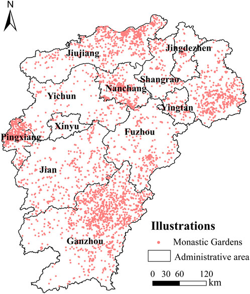
FIGURE 1. Distribution of monasteries and gardens in Jiangxi Province.
2.2 Research methodology
2.2.1 Nearest neighbour index
Nearest proximity is an indicator describing the proximity of point-like elements to each other in geographic space (Yuan et al., 2023). In the case of monasteries and gardens, they can be abstracted as point-like elements of three types: discrete, random and clustered (Zharikov et al., 2005). The closest proximity index can be used to analyse their spatial distribution. The closest proximity index can be used to analyse the type of spatial distribution and is calculated using the following formula.
Where
2.2.2 Geographical concentration index
There are scattered and clustered monastic gardens, and the geographical concentration index can be used (Van Beers and Graedel, 2007). The degree of concentration in the spatial analysis of monastery gardens is studied with the following formula
Where: G is the actual concentration index of monasteries and gardens in Jiangxi Province, the number of monasteries and gardens in the ith city of Jiangxi Province is expressed by
2.2.3 Imbalance index
The imbalance index reflects the degree of equilibrium in the distribution of the study population within the different regions (Kuang et al., 2023) and is calculated as follows.
Where
2.2.4 Nuclear density analysis
Kernel density analysis is a non-parametric estimation method commonly used in spatial analysis for point patterns (Zhu, 2014). It is a visual representation of the distribution of point elements in the temple and garden places in Jiangxi Province, and can calculate the density of point elements around each output raster, which can visually reflect the degree of concentration and dispersion of the temple and garden, and the calculation formula is as follows.
where.
2.2.5 Spatial autocorrelation
Spatial autocorrelation analysis is a measure of the degree of aggregation of attribute values of spatial units (Chen, 2013). The global Moran’s I index and the local Getis-Ord Gi * index (also known as “hotspot” analysis) can be used to measure the overall spatial correlation and the distribution of cold hotspots in the monasteries and gardens of Jiangxi Province, calculated as follows.
Where: n is the number of points, xi, xj are the observed values of i and j at spatial locations, wij denotes the proximity of spatial locations i and j; I = 0, no correlation of points in space, I > 0, positive correlation of points in space, I < 0, negative correlation of points in space.
2.2.6 Geographic detector
Wang Jinfeng’s proposed Geographic Detector (Wang et al., 2010) is an effective statistical method that can be used to study spatial variations and uncover the underlying driving factors. Geographic Detector comprises interactive, ecological, single-factor, and risk detectors. Among these, the single-factor detector is capable of assessing whether a specific independent variable, X, can effectively explain and describe the spatial variations of attribute Y. Its values range from [0, 1], with higher values indicating a stronger explanatory power of the independent variable, and vice versa. This study utilizes the single-factor detector to investigate the driving forces of a particular factor in the spatial distribution of temple and garden landscapes in Jiangxi Province.
Among these, q represents the detection value of the impact factors on the temple and garden landscapes in Jiangxi Province; Nh represents the number of elemental components included in the detection; N represents the number of regional units in Jiangxi Province; and
3 Spatial distribution characteristics of Jiangxi monastery gardens
3.1 Spatial distribution patterns
According to the theoretical nearest neighbor distance formula, using the spatial analysis module in GIS to calculate the nearest neighbor point index of Jiangxi temple and garden, combined with the counted number of 4 317 temple and garden in Jiangxi Province, as shown in Figure 2, we get
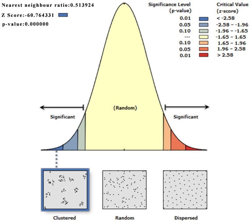
FIGURE 2. Jiangxi Province Temple and Garden Distribution Average Nearest Neighbour Statement (Z score:-60.764331, Then the probability of randomly generating this clustering pattern is less than 1%).
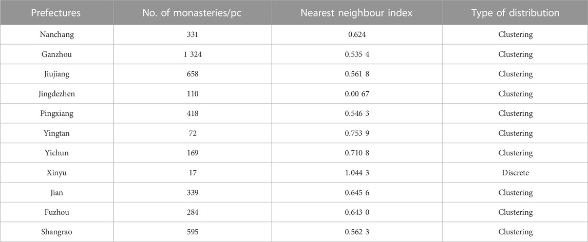
TABLE 1. Spatial Statistics and Nearest Neighbour Index for Monasteries and Gardens by City in Jiangxi Province.
3.2 Concentration of spatial distribution
The geographical concentration index can be calculated to analyse the degree of concentration in the spatial distribution of monastic gardens in Jiangxi Province. The distribution of temple gardens in Jiangxi Province in the 11 prefecture-level cities is shown in Table 2. According to the formula calculated in Excel, the total number of temple gardens in Jiangxi Province t is 4,317, where n is the total number of urban areas in Jiangxi Province is 11, resulting in a geographic concentration index G = 40.56 for the spatial distribution of temple gardens in Jiangxi Province, assuming that temple gardens are evenly distributed within each prefecture-level city, G0 = 30.15. The geographic concentration index G > G0 indicates that from a municipal perspective, the spatial distribution of temple and garden landscapes in Jiangxi Province is relatively concentrated, primarily located in Ganzhou, Jiujiang, Shangrao, and Pingxiang cities. However, the spatial distribution in Yingtuan, Xinyu, and Jingdezhen cities is not as concentrated.

TABLE 2. Municipal distribution of temple gardens in Jiangxi Province.
3.3 Uniformity of spatial distribution
The imbalance index can analyze the uniformity of the distribution of temple and garden landscapes in different prefecture-level cities within Jiangxi province. After performing calculations in an Excel spreadsheet, an imbalance index of S = 0.5044 is obtained. As shown in Figure 3, the Lorenz curve reveals a significant difference in the spatial distribution of temple and garden landscapes in Jiangxi province. The curve has a steeper rise, indicating a notable imbalance in the distribution of temple and garden landscapes in the province. Specifically, the combined total of temple and garden landscapes in three cities, namely Ganzhou, Jiujiang, and Shangrao, accounts for 59.69% of the total, while Xinyu, Yingtan, and Jingdezhen have fewer temple and garden landscapes.
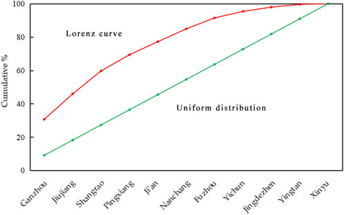
FIGURE 3. Spatial distribution of Lorenz curves in monastic gardens Jiangxi Province
3.4 Spatial distribution density
Using the ‘kernel density estimation’ function in the GIS spatial analysis tool, the 4,317 monasteries and gardens in Jiangxi Province were calculated and mapped (Figure 4). From Figure 4, it can be seen that the municipal distribution pattern of Jiangxi’s monasteries and gardens is consistent with the distribution pattern of kernel density, mainly forming a dense block distribution area with a high degree of continuity in Nanchang, Ganzhou, Jiujiang, Pingxiang and Shangrao, while Yichun, Yingtan, Fuzhou, Jingdezhen, Xinyu and Ji’an are less distributed and do not form a large aggregation area.
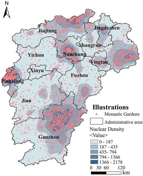
FIGURE 4. Analysis of the overall nuclear density of monastic gardens in Jiangxi Province.
3.5 Spatial autocorrelation analysis
The spatial kernel density analysis shows that there is an overall clustering feature in the spatial distribution of Jiangxi’s monastery gardens, but it is difficult to verify whether there is correlation in the spatial distribution of Jiangxi’s monastery gardens. Therefore, a spatial autocorrelation analysis was conducted to investigate the correlation and the distribution of cold hotspots in the overall spatial distribution of monastery gardens in Jiangxi Province. According to the results shown in Figure 5, the overall Moran’s I for the spatial distribution of Jiangxi Province temple and garden is 0.020 1, the z-value is 0.720 4 and the p-value is 0.471 2, which passed the significance test, this sentence indicates that the spatial distribution of temples and gardens in Jiangxi Province exhibits a positive autocorrelation feature, and the spatial distribution of temples and gardens demonstrates significant proximity characteristics.
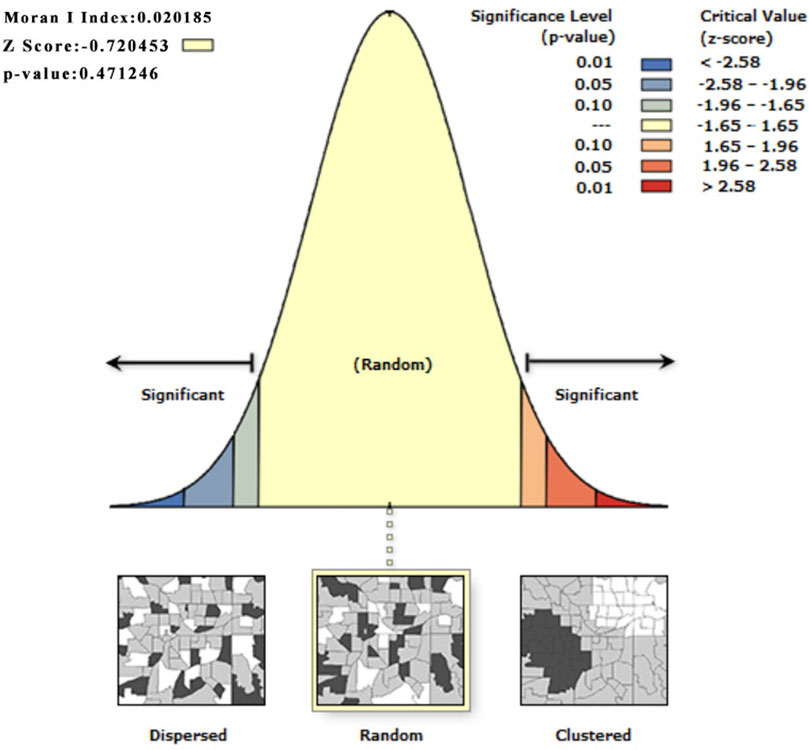
FIGURE 5. Global spatial autocorrelation analysis of monastic gardens in Jiangxi Province(Z score:-0.720453, The difference between this model and the random model dose not appear to be significant).
The analysis of local spatial autocorrelation of monastery gardens can reflect the distribution pattern of monastery gardens among prefecture-level cities. Using the Getis-Ord Gi* tool in GIS, the spatial distribution of monastery gardens in Jiangxi Province was rendered. As shown in Figure 6, the spatial distribution of monasteries and gardens in Jiangxi Province is mainly characterised by “high-high clustering” and “low-low clustering”, with “high-high clustering” reflecting the central High-agglomeration’ reflects the high number of monasteries and gardens in both the central city and the neighbouring cities, represented by Ganzhou City; ‘Low-low-agglomeration’ indicates that the number of monasteries and gardens in both the central city and the neighbouring cities is low, forming a cold spot This is represented by the city of Nanchang. Therefore, the spatial distribution of monastery gardens in Jiangxi Province is characterised by significant positive spatial autocorrelation.
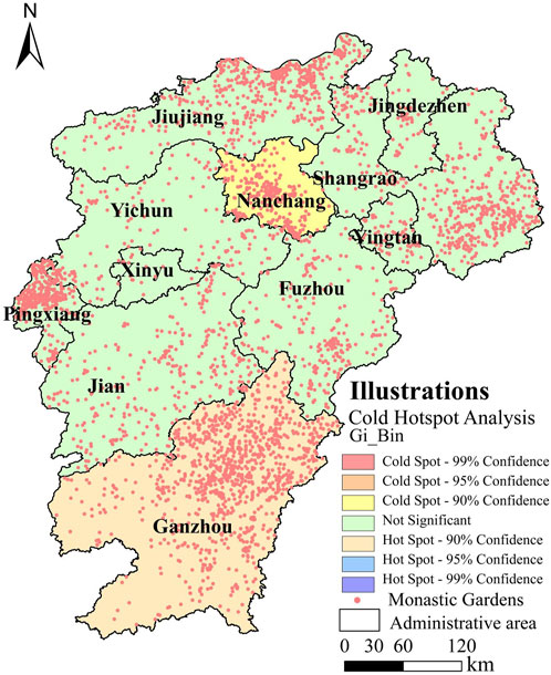
FIGURE 6. Analysis of the local spatial autocorrelation of monastic gardens in Jiangxi Province.
4 Factors influencing the spatial distribution of monastic gardens in Jiangxi
4.1 Geomorphological factors
4.1.1 Elevation factors
Elevation is an important factor affecting the distribution of monastic gardens. The topography of Jiangxi Province is predominantly hilly and mountainous, with the overall terrain being high in the south and low in the north (Yu et al., 2019). According to the topographic characteristics of Jiangxi Province to reclassify the Jiangxi elevation, through the statistical summary to obtain Table 3. The results show that the number of monasteries and gardens in each prefecture decreases as the altitude increases, and the number of monasteries and gardens at different altitudes in different prefectures varies greatly. Most of the monasteries and gardens in each city are located in the 0–200 m plain range, with Nanchang and Ganzhou representing the largest number of monasteries and gardens in this range. In the range of 200–500 m, the number of monastery gardens in Ganzhou City is higher than that of other prefecture-level cities, due to the large geographical area of Ganzhou City and the fact that there are more mountains and hills. In the altitude range above 500 m, the number of monasteries and gardens is generally lower in all prefecture-level cities, as higher altitudes are associated with a higher risk of natural disasters and are not conducive to religious activities.

TABLE 3. Relationship between elevation and number of monastery gardens in Jiangxi Province by prefecture.
Overall (Figure 7), the number of monasteries and gardens is generally distributed in the plains and hills, due to the relatively low and gentle altitude of the terrain, which makes access to water more convenient and facilitates the movement of the faithful and their livelihoods.
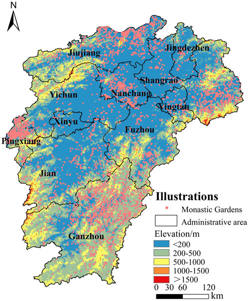
FIGURE 7. Elevation analysis of temple gardens in Jiangxi Province.
4.1.2 Slope factors
Slope is an important indicator of the undulation of the macro terrain (Kravchenko et al., 2000). In Jiangxi Province, there are numerous hills and basins, characterized by significant topographical variations. The slope gradient plays a crucial role in the distribution of temples and gardens. Using GIS, the slope data of Jiangxi was reclassified, and it was subsequently combined with data on temples and gardens in various prefecture-level cities to compile Table 4. From the table, it can be observed that temples and gardens are primarily located in areas with relatively flat terrain. Generally, the number of temples and gardens decreases as the slope gradient increases. Within the slope range of 0–10°, both Ganzhou and Nanchang have a higher concentration of temples and gardens, while Jingdezhen, Yingtan, and Xinyu have fewer in number.
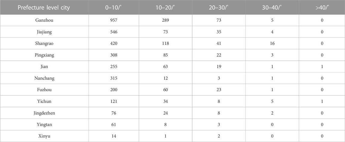
TABLE 4. The relationship between slope and number of monasticgardens in Jiangxi Province at prefecture level.
Overall (Figure 8), the distribution of gardens in Jiangxi’s prefecture-level cities is mainly within the 0°–30° slope range, with the number of monastery gardens in this range accounting for 99.07% of the overall number of monastery gardens, and the number of monastery gardens in the slope range greater than 40° is small in each prefecture-level city. It can be seen that steep slopes have a limiting effect on the location of monasteries and gardens, with steep slopes being detrimental to the construction of monasteries and gardens and the travel of worshippers, while gentler slopes can reduce the labour costs of building monasteries and gardens.
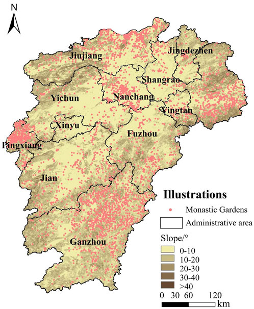
FIGURE 8. Slope analysis of monastery gardens in Jiangxi Province.
4.1.3 River systems
The river system is an important condition affecting the distribution of temple gardens. Jiangxi is rich in water resources, with Poyang Lake, the largest freshwater lake in China, and joins the Ganjiang, Xiushui, Rao, Xin and Fu rivers in the north to join the Yangtze River (Qiu et al., 2021) It is also joined by the Ganjiang, Xiushui, Rao, Xin and Fu rivers in the north to join the Yangtze. The buffer zone analysis of the main water systems in Jiangxi is carried out in GIS, and the ring values are set to 5, 10, 15 and 20 km, as shown in Figure 9. The buffer zones of the rivers were calculated and analyzed by overlaying them with the temple gardens of each prefecture-level city, which were collated in Excel to obtain Table 5. In the distribution of temple gardens in the buffer zones of each city, it can be seen that the distribution of temple gardens in Ganzhou City and Jiujiang City, where the river network is dense, is relatively balanced at different buffer zone distances, and the distribution of the number of temple gardens is relatively concentrated.
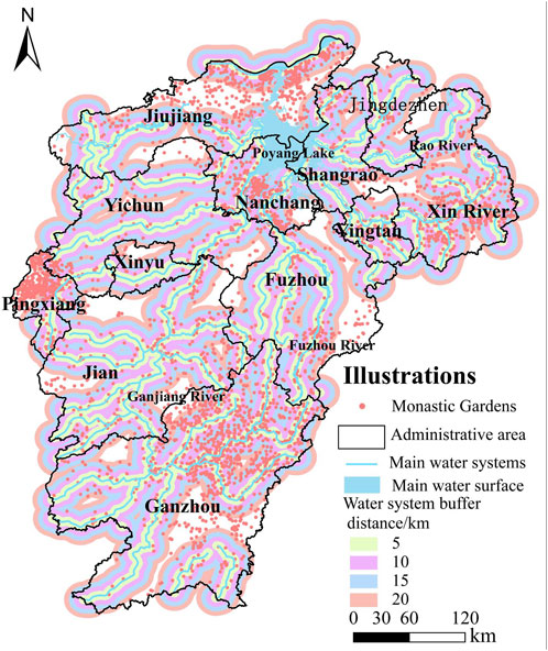
FIGURE 9. Analysis of river buffers in temple gardens in Jiangxi Province.
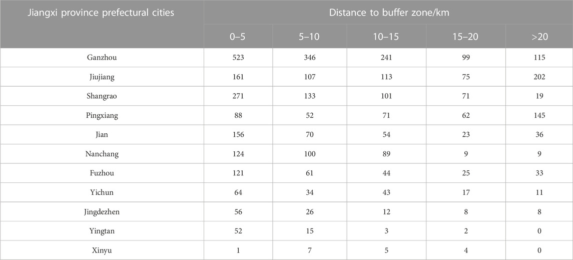
TABLE 5. The relationship between river buffers and the number of monastery gardens in Jiangxi Province by prefecture.
In general, most of the monastery gardens are located along both sides of the river respectively, with 37.46% of the monastery gardens located within 5 km and 22.03% within 5–10 km. Only 13.39% of the monasteries and gardens are located outside the 20 km range. This shows that the distribution of monasteries and gardens is closely related to the pattern of the water network. This is because water not only meets the needs of the inhabitants, but is also an important link for cultural exchange (Wang et al., 2010). The rivers have contributed to the diversification of Jiangxi’s monastic gardens.
4.2 Social factors
4.2.1 Traffic factors
Road traffic is an important factor in economic development (Wang et al., 2023) that affects the distribution of monastery gardens. The road network data of Jiangxi province was imported into GIS, and the road network was subjected to buffer zone analysis, with ring values set at 0.5, 1, 1.5, 2, 2.5 and 3 km, as shown in Figure 10. The buffer zones of the road network were derived after calculation, and were overlaid with the temple gardens of each prefecture-level city for analysis, and were collated in Excel to obtain Table 6. From the table, it can be seen that the number of temple gardens in the buffer zones of Ganzhou and Jiujiang cities at 0.5 km, 1 km, and the number of temple gardens in road buffers greater than 3 km are relatively concentrated in distribution, which, combined with Figure 7, is due to the relatively complex topography of the two prefecture-level cities, with a large proportion of mountains and hills, which affects the distribution of traffic and temple gardens.
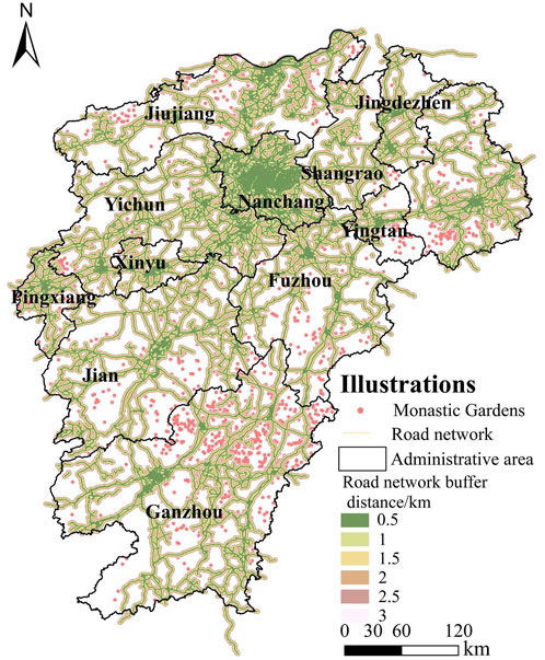
FIGURE 10. Analysis of the buffer zone of the road network of the temple gardens in Jiangxi Province.
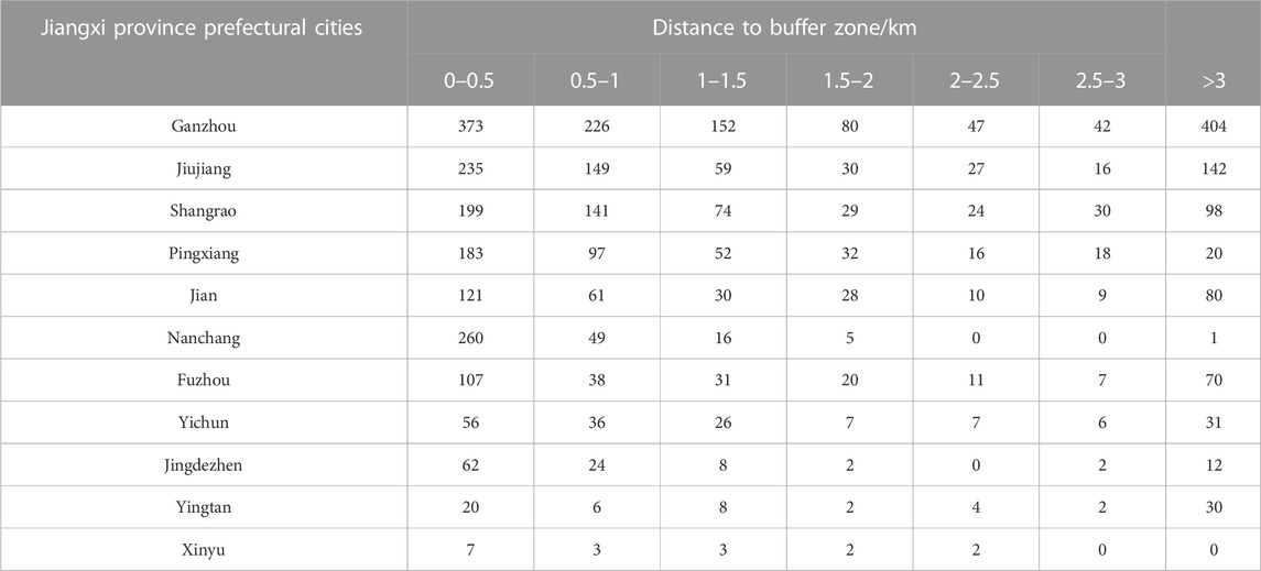
TABLE 6. Relationship between the number of monasteries and gardens andthe distance of the buffer zone of the road network in Jiangxi Province.
In general, the density of the distribution of monastery gardens in each prefecture is mostly within the buffer zone of 0–1.5 km, and the number of monastery gardens in this range accounts for 67.45% of the total number of monastery gardens in each prefecture, and as the buffer zone distance increases, the overall number of monastery gardens in Jiangxi shows a decreasing trend. In summary, transport is an important factor in the distribution of monasteries and gardens at the prefecture level. The convenience of transport helps the faithful to carry out their activities, facilitates their travel to and from the temple, and also facilitates the construction of temple gardens.
4.2.2 Economy factors
The development of monastery gardens cannot be separated from economic factors (Gustavsson and Morrissey, 2019); the faster the economic development, the more money and labour the local government invested in the construction of monastery gardens, and the number of monastery gardens was bound to increase. Due to the difficulties in obtaining data on the level of economic development of the ancient prefecture-level cities in Jiangxi and the statistics on the temple gardens in the relevant historical period, the relevant data for 2022 is used as a reference.
According to the 2022 Statistical Bulletin on National Economic and Social Development of Jiangxi Province, published by Jiangxi Province in 2022, the collated results are shown in Table 7, in which Nanchang City, Ganzhou City and Jiujiang City have the highest GDP value in the province, and the three prefecture-level cities also have more monasteries and gardens, with the total number of monasteries and gardens accounting for 49.16% of the monasteries and gardens in Jiangxi Province. This shows that there is a strong correlation between regional economic development and the development of monasteries and gardens. The better the regional economic development, the more importance the government attaches to the conservation of landscape and garden heritage and the more money it invests, which is conducive to the development of monasteries and gardens. At the same time, the increase in population brought about by the economic development of a region inevitably leads to an increase in the number of religious followers, which further contributes to the development of monastic gardens.
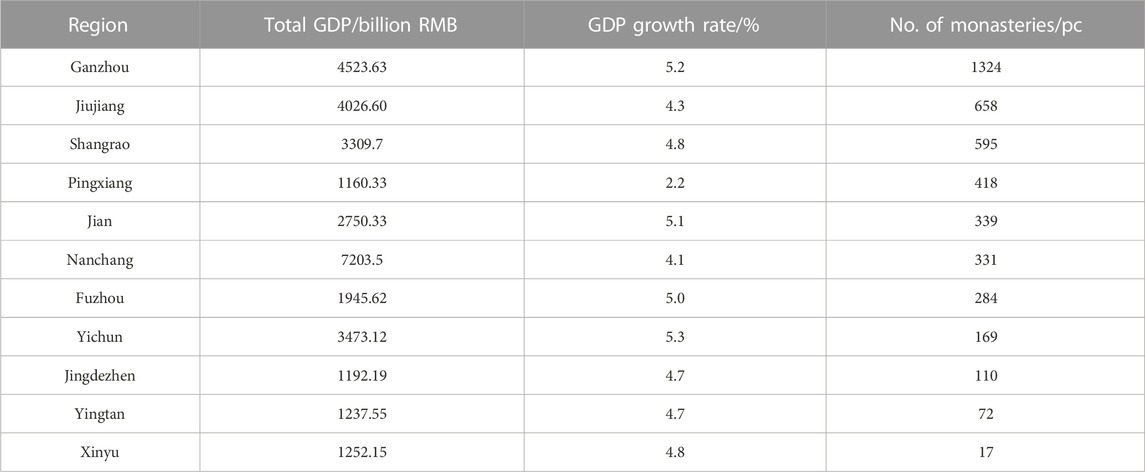
TABLE 7. Economic and monastic garden quantitative RelationshipsinJiangxi province at the prefectural level in 2022.
4.2.3 Regional cultural factor
Regional culture refers to the distinct cultural characteristics that develop in different geographical regions due to variations in natural and human environments (Xie et al., 2022). Jiangxi Province, with its diverse topography and rich cultural heritage, has given rise to a wide array of regional cultures. Some of the prominent regional cultures in Jiangxi include Gan culture, Luling culture, Linchuan culture, Hui culture, Xunyang culture, Yuzhang culture, and Yuanzhou culture. When examining the spatial distribution of temple and garden landscapes in Jiangxi Province, it is evident that these landscapes are primarily concentrated in regions influenced by Gan culture, Hui culture, Xunyang culture, and Yuzhang culture as shown in Figure 11.
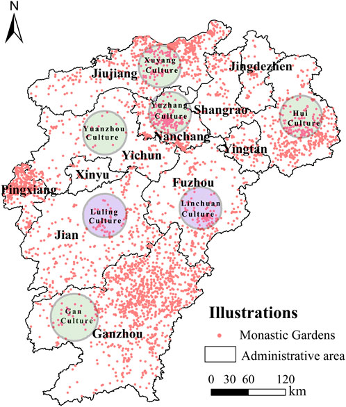
FIGURE 11. Jiangxi Province regional cultural district.
Gan culture, which is synonymous with the culture of southern Jiangxi, is renowned for its rich traditional arts, strong agricultural traditions, abundant natural resources, and diverse ethnic influences. Temple and garden landscapes associated with Gan culture are primarily concentrated in the northern and central parts of the region. This area has a historical legacy that dates back to the Five Dynasties and Ten Kingdoms period, with its epicenter being the Zhanggong district. Over the centuries, as society stabilized and the economy prospered, the flourishing of Neo-Confucianism during the Song and Ming dynasties further bolstered the construction of temple and garden landscapes. Notable examples include Ciyun Temple and Guangxiao Temple.
Hui culture, originating in ancient Huizhou, which spans one prefecture and six counties, is a combination of material and spiritual civilization. One of its representative areas within Jiangxi is Shangrao City. Temple and garden landscapes related to Hui culture trace their origins back to the Eastern Han period. Zhang Daoling, the founder of Taoism, once secluded himself at Longhu Mountain in Guxi County, and Ge Xuan also practiced Daoism on Ge Xian Peak in Yiyang County. During the Song Dynasty, the ruling class greatly esteemed Buddhist and Taoist cultures. The close economic interactions of Hui merchants contributed to the flourishing of temple and garden landscapes in the region. Notable examples include the Gexian Temple in Lianshan County, the Puning Temple in Yushan County, and the Nanyan Temple in Yiyang County.
Xunyang culture is primarily associated with Jiujiang City, and it has a long and profound history. During the Wei, Jin, Northern and Southern Dynasties period, the region of Jiujiang had a strong culture of seclusion and philosophical thinking. Cultural exchanges were frequent, attracting numerous tourists and recluses to gather in the picturesque Lushan Mountain. This led to the establishment of temple and garden landscapes such as Donglin Temple and Jiguan.
Yuzhang culture refers to the local culture of Nanchang City, particularly the Qinghu District. Temple and garden landscapes emerged during the Wei, Jin, and Northern and Southern Dynasties period. Xu Xun, the founder of the Daoist Pure Brightness School, once preached at Xiaoyao Mountain in the western suburbs of Nanchang. During the Tang Dynasty, Taoist culture thrived, and interactions among literati were intense. Temple and garden landscapes in the Yuzhang region further prospered, mainly constructed in the picturesque natural areas, particularly in mountainous regions, like Nengren Temple and Dingkong Temple.
These regional cultures in Jiangxi have significantly contributed to the development and uniqueness of temple and garden landscapes in their respective areas. They have shaped not only the architectural elements but also the cultural and spiritual essence of these sites. This cultural diversity should be harnessed to promote tourism and protect these valuable heritage sites.
4.2.4 Population factors
Population, as a replenishable resource, plays a significant role in the distribution of temple and garden landscapes (Zhao et al., 2022). To verify the relationship between modern population and the existing temple and garden landscapes, data from the Jiangxi Provincial Bureau of Statistics for the year 2022 were used to compare the population numbers, population density, and the number of temple and garden landscapes in various prefecture-level cities (Table 8). As shown in the table, Ganzhou City has the highest population and the largest number of temple and garden landscapes, with 1324 sites. However, the population density is relatively low at only 228 people per square kilometer. This is due to the large land area of Ganzhou City, which is characterized by hilly and mountainous terrain, resulting in a less concentrated population distribution.
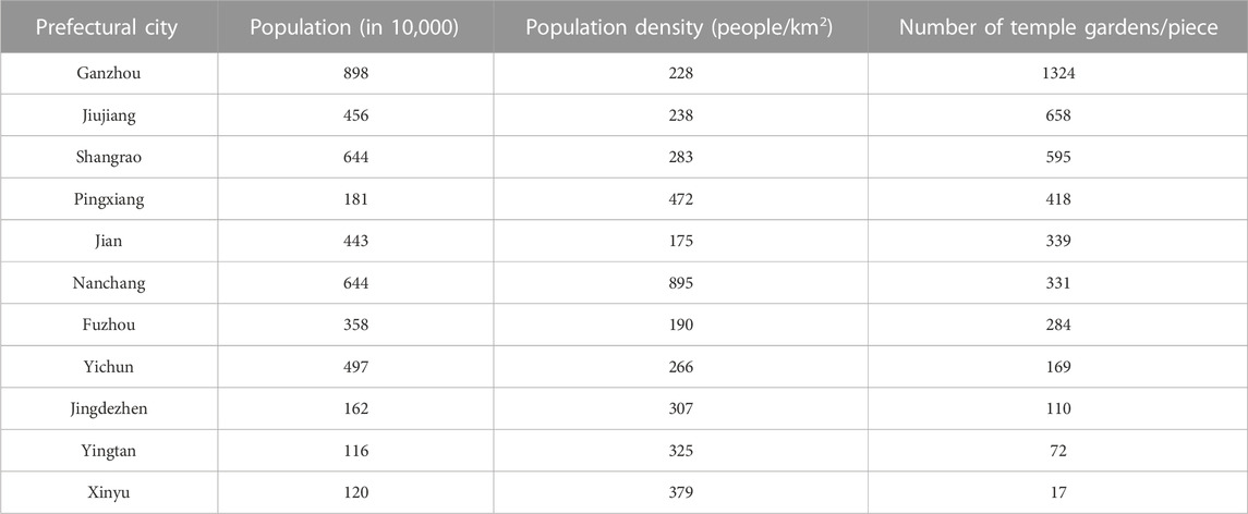
TABLE 8. Population distribution and number of temple and garden landscapes in various cities of Jiangxi province.
Other cities with low population density include Jiujiang City and Shangrao City, but they have a relatively higher number of temple and garden landscapes. In contrast, Nanchang City has a high population density, primarily characterized by flat plains, with a density of 895 people per square kilometer, but it has a relatively lower number of temple and garden landscapes, only 331 in total. Similarly, cities with high population density like Xinyu City, Yingtuan City, and Jingdezhen City also have fewer temple and garden landscapes.
This data suggests that areas with a higher population density tend to have fewer temple and garden landscapes, while regions with lower population density have a greater abundance of these cultural and religious sites. The distribution of temple and garden landscapes appears to be inversely related to the population density, which may be influenced by factors such as urban development, land availability, and cultural history.
4.2.5 History factors
The history and culture of religion in Jiangxi Province has played an important role in the development of monastic gardens. With its beautiful mountains and scenery, Jiangxi has traditionally been a place of cultural prosperity, The region has a rich cultural heritage (Leung, 2009). Jiangxi has traditionally played an important role in the cultural spread of Buddhism and Taoism. During the Wei-Jin and Northern and Southern Dynasties, Jiangxi became one of the first regions to introduce Buddhism, and Buddhist temple gardens developed on this basis; Taoist temples also came to prominence during this period, with 64 Taoist gardens in Jiangxi during the Wei-Jin and Northern and Southern Dynasties. During the Wei, Jin and Northern Dynasties, there were 64 Taoist gardens in Jiangxi. During the Sui and Tang dynasties, Buddhism in Jiangxi flourished, with several sects co-existing, showing a prosperous scene of ‘one flower and five leaves’. The number of Taoist temples in Jiangxi developed further, and the number of verifiable Taoist temples in Jiangxi reached 124 during the Tang Dynasty (Yuhang, 1994). During the Yuan, Ming and Qing dynasties, the development of Buddhist and temple gardens in Jiangxi was relatively slow and the number was less than in previous generations, but there was greater progress in the art of gardening in the temple gardens. In recent times, with the progress of social development, especially since the reform and opening up in 1978, the Party’s religious policy has been further improved, and coupled with the strengthening of Jiangxi’s religions in their own construction and management of their places of activity, it has led to the rapid development of various religious sites (Hesed, 2013), The development of religious sites in Jiangxi has been rapid.
4.3 Exploration of key drivers
The distribution of monasteries and gardens in Jiangxi Province is influenced by a combination of factors. Combining the geographical characteristics and the actual situation of the study area, a geographical probe can be used to summarise and summarise the factors influencing the spatial distribution characteristics of monasteries and gardens in Jiangxi. In this paper, five aspects, namely GDP (X1), elevation (X2), slope (X3), water system (X4) and road network (X5), are selected as indicator elements. With the help of the natural breakpoint method in GIS, the elements were divided into five categories, and then the data were substituted into the geodetector to resolve the degree of influence of the factors, and the structure is shown in Table 9.
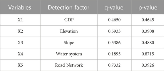
TABLE 9. Geographical detection of factors influencingthe spatial distribution of monastic gardens in Jiangxi province.
The results show that the influence of each factor is ranked as road network > elevation > slope > GDP > water system, which shows that the natural environmental factors and socio-economic factors interact to influence the spatial distribution of monastery gardens, among these factors, the road network exerts the most significant influence, followed by elevation, slope, and water systems.
5 Conclusions of the study
Taking 4,317 monasteries and gardens in prefecture-level cities of Jiangxi Province as the research objects, the spatial distribution pattern and the influencing factors were analysed through GIS technology and methods, and the conclusions of the study are as follows:
Firstly, the distribution of Jiangxi’s monastery gardens is spatially agglomerative, showing an overall spatial distribution pattern of “overall dispersion and concentration in some areas”.
Secondly, the distribution of monasteries and gardens in Jiangxi Province is uneven, with large differences in spatial distribution in different areas and consistency in the distribution of the nuclear density of monasteries and gardens and the distribution of municipalities.
Third, there are positive autocorrelation characteristics in the global spatial distribution of monasteries and gardens in Jiangxi Province, and each prefecture-level city has obvious proximity characteristics. At the same time, local autocorrelation analysis shows that there is a significant spatial autocorrelation between the spatial distribution of monasteries and gardens in each prefecture-level city, forming a “high-high concentration” and a “low-low concentration” trend.
Fourth, Temple gardens in various regions are affected by geomorphological factors and are mostly concentrated in the lower altitude range of 0–500 m and the gentle slope of 0°–30°. Most of the distribution density of temple gardens in various prefecture-level cities is within the buffer zone distance of the road network within the range of 0–1.5 km.
Fifth, economic, cultural, demographic and historical factors have affected the development of temple gardens. Areas with more active economies have a denser number of temple gardens. Unique regional culture affects the distribution of temples and gardens in different regions. In places where the modern population is densely distributed, there are fewer temples and gardens, while in places where the population is less densely distributed, there are more temples and gardens.
Sixth, Use geographical detectors to conduct single-factor detection on GDP, elevation, slope, water system, and road network. It shows that the greatest impact on the spatial distribution of temple gardens in Jiangxi Province is the road network, followed by elevation, slope, GDP, and water system. Discussion.
6 Conclusion
This study can provide valuable insights for the exploration of the unique tourism features of temple and garden landscapes in Jiangxi Province, the preservation of their cultural heritage, and the implementation of comprehensive protection and utilization efforts. The topographical features and road network play significant roles in influencing the distribution of temple and garden landscapes in Jiangxi Province. In areas with complex topography like Ganzhou, Ji’an, and Fuzhou, characterized by mountainous and hilly terrain resulting in dispersed population and low population density, there is a need to actively strengthen the construction of road networks and supplement corresponding infrastructure. This will facilitate increased interaction between people and temple and garden landscapes, thus promoting tourism development. In areas with relatively flat terrain, such as Nanchang, which have higher population density, efforts should focus on promoting and protecting temple and garden landscapes, enhancing commercial development in their vicinity, attracting visitors, and encouraging the use of digital and virtual reality tools to reconstruct the historical changes in these landscapes. This approach will aid in the better preservation of cultural heritage.
The presence of water systems is another vital factor influencing the distribution of temple and garden landscapes. These landscapes are predominantly found within 5 km of water systems. Therefore, local authorities should prioritize the conservation of water resources, emphasize environmental and ecological development of water resources, and transform these resources into beautiful local tourist attractions. An example is the Poyang Lake Nanshan Scenic Area in Duchang County, Jiujiang City, where the picturesque lake and its surroundings are rich in temple and garden resources, such as the Nanshan Temple and Guanyin Pavilion. The government can maximize the potential of these water resources to boost the tourism industry around temple and garden landscapes.
Local authorities should assess the actual development of temple and garden landscapes, leverage regional culture and tourism resources, fully explore the cultural significance of these landscapes, and focus on protecting prominent and historically rich temple and garden sites. For instance, areas with a deep historical legacy like the Lushan Scenic Area in Jiujiang City, known as a renowned tourist destination and a hub for both Buddhist and Taoist culture, feature prominent temples like Dalin Temple, Xilin Temple, and Donglin Temple. Regions with a rich cultural heritage, such as Sanqingshan in Shangrao City, offer picturesque landscapes and are significant in Taoist culture, housing the well-known Sanqing Palace and Yuhuang Palace. Local authorities should unlock the tourism potential of temple and garden landscapes, capitalize on regional cultural attributes, encourage collaboration and cultural exchange between different regions, and promote the development of the tourism industry around these landscapes.
Local governments should also intensify their economic development efforts and offer specific policies and funding support for temple and garden landscapes. For instance, the Jiangxi Provincial Forestry Bureau introduced the “Regulations on Scenic Spots” in 2021, which provides legal guidelines for the protection of temple and garden landscapes and other scenic areas. Relevant departments in local governments should establish a comprehensive monitoring and assessment system for temple and garden landscapes, conducting regular evaluations of their protection status, ecological environment, and cultural heritage. This proactive approach will help identify and address issues in a timely manner. Governments should also actively engage in research on temple and garden landscapes, delving into their historical, cultural, and architectural characteristics, to provide a scientific basis for preservation efforts.
While this study employed GIS analysis tools to qualitatively and quantitatively analyze the spatial distribution patterns and influencing factors of 4,317 temple and garden landscapes in Jiangxi Province from both provincial and municipal perspectives, it has certain limitations. The data sample used in this study requires further expansion. The selection of temple and garden landscapes was based on information screened by the State Administration for Religious Affairs. In reality, there may be other temple and garden landscapes in various municipal regions of Jiangxi that have not been accounted for. Subsequent research should involve practical fieldwork and the examination of local historical records to ensure the study data’s rigor and completeness.
Data availability statement
The original contributions presented in the study are included in the article/Supplementary Material, further inquiries can be directed to the corresponding authors.
Author contributions
Conceptualization, TZ; data collection, TZ; methodology, TZ; data analysis, YH; software, YH; writing—original draft preparation, TL; resources, YH; review and editing, TL; supervision, HH. All authors contributed to the article and approved the submitted version.
Funding
This research project was supported by a project grant from the Natural Science Foundation of Heilongjiang Province (co-guided project) under grant number LH 2021E006.
Conflict of interest
The authors declare that the research was conducted in the absence of any commercial or financial relationships that could be construed as a potential conflict of interest.
Publisher’s note
All claims expressed in this article are solely those of the authors and do not necessarily represent those of their affiliated organizations, or those of the publisher, the editors and the reviewers. Any product that may be evaluated in this article, or claim that may be made by its manufacturer, is not guaranteed or endorsed by the publisher.
Supplementary Material
The Supplementary Material for this article can be found online at: https://www.frontiersin.org/articles/10.3389/fenvs.2023.1252231/full#supplementary-material
References
Asl, S. R., and Azadgar, A. (2022). The spatial distribution of urban community gardens and their associated socio-economic status in Tehran, Iran. Front. Sustain. Food Syst. 6, 949075. doi:10.3389/fsufs.2022.949075
Campo, D. (2022). Female education in a chan public monastery in China: the Jiangxi dajinshan buddhist Academy for nuns. Religions 13 (11), 1020. doi:10.3390/rel13111020
Certain, G., Bellier, E., Planque, B., and Bretagnolle, V. (2007). Characterising the temporal variability of the spatial distribution of animals: an application to seabirds at sea. Ecography 30 (5), 695–708. doi:10.1111/j.2007.0906-7590.05197.x
Chen, Y. (2013). New approaches for calculating moran’s index of spatial autocorrelation. PLoS ONE 8 (7), e68336. doi:10.1371/journal.pone.0068336
Dean, K. (2003). Local communal religion in contemporary south-east China. China Q. 174, 338–358. doi:10.1017/S0009443903000214
Gustavsson, M., and Morrissey, K. (2019). A typology of different perspectives on the spatial economic impacts of marine spatial planning. J. Environ. Policy & Plan. 21 (6), 841–853. doi:10.1080/1523908X.2019.1680274
Hesed, C. D. M. (2013). The new holy wars: economic religion vs. Environmental religion in contemporary America. Rev. Soc. Econ. 71 (1), 123–126. doi:10.1080/00346764.2012.662787
Kravchenko, A. N., Bullock, D. G., and Boast, C. W. (2000). Joint multifractal analysis of crop yield and terrain slope. Agron. J. 92 (6), 1279–1290. doi:10.2134/agronj2000.9261279x
Kuang, R., Zuo, Y., Gao, S., Yin, P., Wang, Y., Zhang, Z., et al. (2023). Research on the spatial distribution characteristics and influencing factors of Central China’s intangible cultural heritage. Sustainability 15 (7), 5751. Article 7. doi:10.3390/su15075751
Leung, B. (2009). Religious diversity and public religion in China. Relig. State Soc. 37 (3), 333–335. doi:10.1080/09637490903056633
Pan, L., Gan, W., Chen, J., and Ren, K. (2023). An integrated model for constructing urban ecological networks and identifying the ecological protection priority: a case study of Wujiang District, suzhou. Sustainability 15 (5), 4487. doi:10.3390/su15054487
Wang, J., Li, X., Christakos, G., Liao, Y., Zhang, T., Gu, X., et al. (2010). Geographical detectors-based health risk assessment and its application in the neural tube defects study of the heshun region, China. Int. J. Geogr. Inf. Sci. 24 (1), 107–127. doi:10.1080/13658810802443457
Wang, R. G. (2012). THE MING PRINCELY PATRONAGE OF DAOIST TEMPLES. Ming Stud. 2012 (65), 57–92. Q2. doi:10.1179/0147037X12Z.0000000003
Wang, Z., Lu, F., Liu, Z., Tu, W., Nie, K., Du, Q., et al. (2023). Measuring spatial nonstationary effects of POI-based mixed use on urban vibrancy using Bayesian spatially varying coefficients model. Int. J. Geogr. Inf. Sci. 37 (2), 339–359. doi:10.1080/13658816.2022.2117363
Xie, G., Zhou, Y., and Liu, C. (2022). Spatial distribution characteristics and influencing factors of Hakka traditional villages in fujian, guangdong, and Jiangxi, China. Sustainability 14 (19), 12068. Q3. doi:10.3390/su141912068
Xu, Z., Dong, B., Wang, C., Gao, X., Xu, H., Wei, Z., et al. (2023). Construction of international important wetland White-headed crane ecological corridor in Chongming Dongtan, China. Ecol. Indic. 149, 110156. Q2. doi:10.1016/j.ecolind.2023.110156
Yin, Z., Liu, Y., and Pan, Y. (2021). Evaluation and classification of rural multifunction at a grid scale: a case study of Miyun District, beijing. Sustainability 13 (11), 6362. doi:10.3390/su13116362
Yu, D., Ramsey, R. D., Zhao, X.-M., Fu, Y.-Q., and Sun, C.-K. (2019). Feasible conversion degree of dryland to paddy field in Jinxian County, Jiangxi province, China. Geocarto Int. 34 (9), 1042–1053. doi:10.1080/10106049.2018.1452988
Yu, G., Gan, H., and Guo, Y. (2023). Location and fortune: an exploration of the buddhism and daoism roles of geomancy in the Song dynasty. Religions 14 (7), 859. doi:10.3390/rel14070859
Yuan, D., Wu, R., Li, D., Zhu, L., and Pan, Y. (2023). Spatial patterns characteristics and influencing factors of cultural resources in the yellow river national cultural park, China. Sustainability 15 (8), 6563. doi:10.3390/su15086563
Zhang, Z., Wan, Z., Xu, S., Wu, H., Liu, L., Chen, Z., et al. (2023). Environmental adaptation in the process of human-land relationship in southeast China’s ethnic minority areas and its significance on sustainable development. Int. J. Environ. Res. Public Health 20 (3), 2737. doi:10.3390/ijerph20032737
Zhao, Y., Liu, J., and Chen, Y. (2022). A creative analysis of factors affecting the landscape construction of urban temple garden plants based on tourists’ perceptions. Sustainability 14 (2), 991. Q3. doi:10.3390/su14020991
Zharikov, Y., Skilleter, G. A., Loneragan, N. R., Taranto, T., and Cameron, B. E. (2005). Mapping and characterising subtropical estuarine landscapes using aerial photography and GIS for potential application in wildlife conservation and management. Biol. Conserv. 125 (1), 87–100. doi:10.1016/j.biocon.2005.03.016
Keywords: GIS, monastic gardens, tourism, conservation, influencing factors
Citation: Zhang T, Hu Y, Lei T and Hu H (2023) A GIS-based study on the spatial distribution and influencing factors of monastic gardens in Jiangxi Province, China. Front. Environ. Sci. 11:1252231. doi: 10.3389/fenvs.2023.1252231
Received: 03 July 2023; Accepted: 27 October 2023;
Published: 09 November 2023.
Edited by:
Venkatramanan Senapathi, Alagappa University, IndiaReviewed by:
Gnanachandrasamy Gopalakrishnan, Pondicherry University, IndiaSivakumar Karthikeyan, Alagappa University, India
Copyright © 2023 Zhang, Hu, Lei and Hu. This is an open-access article distributed under the terms of the Creative Commons Attribution License (CC BY). The use, distribution or reproduction in other forums is permitted, provided the original author(s) and the copyright owner(s) are credited and that the original publication in this journal is cited, in accordance with accepted academic practice. No use, distribution or reproduction is permitted which does not comply with these terms.
*Correspondence: Tingting Lei, bGVpdGluZ3RpbmdAbmVhdS5lZHUuY24=; Haihui Hu, aGxqaHVhaGlodWlAMTYzLmNvbQ==