 Yanping Li
- 1First Institute of Oceanography, Ministry of Natural Resources, Qingdao, Shandong, China
- 2College of Environmental Science and Engineering, Ocean University of China, Qingdao, Shandong, China
- 3School of Economics and Resource Management, Beijing Normal University, Beijing, China
As two spatial geographic units that are both independent of each other and closely linked, the land and sea have complex spatial interactions. Therefore, China implements the land-sea coordination policy (LSC) needs to be approached from a more macroscopic, systematic and comprehensive perspective. Based on the interregional externality theory, this study takes the land-sea coordination policy of China as an example, and focuses on the interaction process and manifestation between land and sea, and then explores the connotation and realization path of LSC. Firstly, we delineated the spatial unit and analyzed the land-sea interactions (LSI) using Vensim software. Secondly, the characteristics and manifestations of LSI are summarized from the perspective of interregional externalities. Finally, this study elucidates the foundational concept of implementing LSC and further propose actionable pathways for promoting land and sea development in a coordinated way, aimed at offering supportive decision-making insights for achieving LSC within the broader framework of China’s territorial spatial planning. Initiating LSC implementation involves strategies such as source control, process management, and interaction interface optimization. Deepening LSC effectiveness entails strengthening positive interregional externalities while mitigating negative interregional externalities.
1 Introduction
The coastal zone is the important spatial intersection of the land and the sea, and has gradually developed into an area with the greatest potential for economic and social development, due to its unique conditions in terms of resources, climate, transportation and the human environment (Li et al., 2021). However, along with the rapid economic and social development of coastal areas, the development and utilization of coastal zones in recent decades have gradually shown the characteristics of high intensity, complexity and diversification, which has triggered a series of problems such as damage to ecosystems, coastal erosion, reduction of biodiversity, pollution of the marine environment and insufficient supply of resources. Although China’s central and local governments have been exploring optimal integrated coastal zone management models for a long time, the dichotomous governance of land and sea has become a key constraint to the improvement of spatial governance capacity in the region. In 2018, the Chinese government established the Ministry of Natural Resources (MNR) to unify the exercise of spatial management responsibilities for both land and sea, and carried out reforms of the territorial spatial planning, realizing the unified compilation and implementation of spatial planning for both land and sea. Against this background, the concept of the land-sea coordination policy (LSC) has received widespread attention from government administrations and planning academies, expecting that territorial spatial planning based the concept of LSC will help improve the comprehensive management capacity of the coastal zone and the high-quality development of the coastal regions.
With the rapid development of the marine economy, the concept of marine spatial governance and the land-sea coordination extended therefrom have begun to receive the attention of Chinese academics and management departments. In 2010, the Chinese Government introduced the concept of “land-sea coordination (LSC)” for the first time. In a narrower sense, LSC pertains to the integrated planning and allocation of resources, production factors, and other elements across both terrestrial and maritime domains. This aims to achieve effective alignment between land policies and ocean policies. In a broader sense, LSC encompasses comprehensive coordination across dimensions such as economic development, social and cultural progress, environmental sustainability, resource management, transportation infrastructure, urban governance, and other related areas (Han and Li, 2015). The connotation of LSC implies the distinctive features and inherent requirements of unity, wholeness, coordination and three-dimensionality, which is an all-round and high-level strategic thinking (Li et al., 2022). Over the past decade, “land-sea coordination (LSC)” has ascended to the status of a national strategy in China, garnering increasing attention from scholars. There has been a growing recognition of LSC’ s constructive impact in safeguarding territorial spatial security, optimizing the pattern of territorial spatial development and protection, and fostering high-quality development of the national economy. Consequently, there has been a profound exploration into the essence of LSC, the economic interplay between land and sea, the preservation of land and sea ecosystems, and the integrated management of coastal areas (Makino et al., 2013; Zaucha et al., 2016; Caviedes et al., 2020). However, at this stage, the fragmented governance of land and sea management sectors still restricts the realization of LSC. Until 2018, the formation of the Ministry of Natural Resources laid the organizational foundation for the further deepening of LSC. In 2019, Chinese Government initiated the compilation of land spatial planning and marine spatial planning within a unified framework, wherein LSC has become the fundamental principle guiding the compilation of China’s national territorial spatial planning in coastal regions. Scholars began to pay attention to the theoretical basis, methodological innovation and practical application of LSC in the field of territorial spatial planning (Zaucha and Jay, 2022; Baker et al., 2023; Qu et al., 2023; Yao et al., 2023).
At the international level, integrated coastal zone management (ICZM), which originated in the 1970s, embodies the idea of unified management of land and marine resources and the realization of synergistic development of land and sea. ICZM focuses on the formulation of management strategies, the evaluation of management effects, the management model, and public participation in the management process, etc., and its objectives, contents, and means of implementation are richer and the system is more complete than that of the LSC (Halpern et al., 2009; Ngoran and Xue, 2015; Khelil et al., 2019; Brooks et al., 2022). During the same period, research on LSI was initiated in various countries around the world. LSC was first proposed by the field of natural sciences to reveal the effects of changes in various parts of the Earth system on the coastal zone in order to scientifically evaluate changes in the coastal zone due to human impacts (Wilkinson et al., 1997; Poulos et al., 2000; Matear and Wang, 2010). At the beginning of the 21st century, the research on LSI was extended to the field of marine spatial planning, which began to emphasize the interaction between coastal zones and human activities as well as the integrated management of the land and the sea (Vanclay, 2012; Pinillos et al., 2023; Hua et al., 2024). The relevant theories and technical methods have been widely practiced in many countries, which has improved the scientific nature of coastal zone management and marine spatial planning (Reis et al., 2014). For example, the California state in the United States has implemented classified management of spatial units with different functions in coastal areas, and the United Kingdom has integrated unified management of land-sea interfaces by defining the boundaries between land spatial planning and marine spatial planning (Smith et al., 2011; Turner and Essex, 2016). There exists a notable alignment between LSI and LSC in their mutual concern for the dynamic interconnection between land and sea. Stemming from the realm of natural sciences, LSI underscores the scientific rigour of planning methodologies, the procedural soundness, and the utilization of findings from natural sciences research in planning endeavors.
In addition to spatial planning, scholars have also explored the implementation path of LSC from the aspects of total pollutant control, coastal industrial layout, and land-sea transportation system (Guan et al., 2016; Li et al., 2018; Ren et al., 2024; Jung and Thill, 2022). In terms of research on total pollutant control, rapid socio-economic development has led to a continuous increase in the total amount of land-based pollutants discharged from the land space to the sea space. Since the 1970s, scholars both domestically and internationally have made notable advancements in various aspects concerning coastal areas. These include the assessment of overall land-based pollutant quantities, the development of methodologies and technologies for allocating pollutant discharge quotas, the advancement of pollutant emission reduction technologies, and the remediation of marine environmental pollution (Huang et al., 2013; Pantusa et al., 2023; Guggisberg, 2024). In terms of coastal industrial layout, in-depth studies have been conducted on the measurement of the level of land-sea economic integration, the layout of coastal industries, and the assessment of the ecological impact of coastal industrial development (Hsieh and Li, 2009; Mejjad et al., 2022; Ni et al., 2024). In addition, the land and sea transportation system is an important node connecting land space and sea space. Scholars have focused on the measurement of the effectiveness of port transportation development in the coastal zone, the evaluation of spatial suitability and optimization of its regional pattern, the planning of shipping routes, and the control of flow in coastal ports from the perspective of multidisciplinary and multifactorial research (Saeidpour et al., 2019; Zhang et al., 2023; Chen et al., 2024).
In conclusion, China’s exploration of LCS centers on conceptual frameworks, underlying meanings, and tailored planning initiatives. Internationally, while there lacks a precise definition or terminology for land-sea integration, concepts like ICZM and LSI posited by foreign scholars similarly advocate for the amalgamation of land and marine resource management, aiming at synergistic development of both domains. Nevertheless, existing research outcomes in these domains predominantly concentrate on legal frameworks, policies, procedural methodologies, among other aspects. The complexity of various types of spatial activities in the coastal zone area and the intertwining, integration and mutual influence of various connections make it difficult for researchers to research the LSC from the perspective of a single scale, a single process or a single dimension. There is an imperative to develop a robust and pragmatic theoretical analytical framework for the examination of LSC, aiming to comprehensively address inquiries concerning its theoretical underpinnings, scope, technical methodologies, and other pertinent aspects. This study introduces the interregional externality theory, analyzes the whole process and manifestation of the interaction between the two major spaces of the land and the sea at the macro level, focuses on the effects and characteristics of the interaction between different functional spatial units at the meso level, and researches the dynamic relationship between the spatial utilization activities and the natural environment in each region at the micro level. Building upon this foundation, the study delves into a comprehensive examination of the connotation and the implementation path of LSC, aiming to offer guidance for integrating economic development and ecological preservation in coastal zones. The overall research framework of the article is shown in Figure 1.
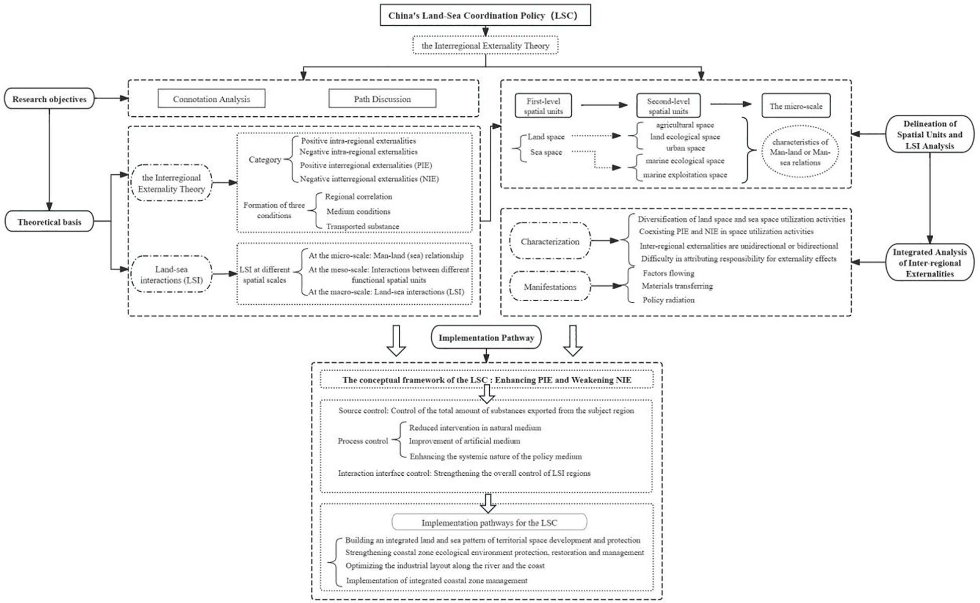
Figure 1 Research Framework.
2 Theoretical foundation: the interregional externality theory
2.1 Interregional externality theory: concept and formation conditions
The externality is the important economic concepts, introduced by the British welfare economist Pegu. It refers to an economic activity of an individual or group that imposes unreimbursed benefits or unrecoverable costs on other individuals or groups. The unreimbursed benefits are called positive externalities, while the unrecoverable costs are called negative externalities. As an open system, regional development is bound to have a positive or negative impact on other regions in accordance with the law of geographical diffusion (Duan et al., 2010; Lu, 2011; Lu et al., 2018). Therefore, the externalities theory is one of the important analytical tools in research in the fields of economic geography and regional economics, where the region is the object of study (Han and Ke, 2013; Ren et al., 2021). Due to the hierarchical and spatially differentiated nature of economic activities and their environmental impacts, externalities exhibit distinct ecological, economic, social, and other characteristics across varying spatial scales. Externalities can be categorized into intra-regional externalities and inter-regional externalities according to the spatial scope of influence. Intra-regional externalities are the effects of economic activity within a region on itself, while inter-regional externalities are the effects of economic activities within a region on other regions. If the effect of interregional externalities are positively contributing, it is called positive interregional externalities(PIE), and vice versa, it is called negative interregional externalities(NIE) (The criteria for determining “positive impact” and “negative impact” are shown in the Appendix 1). Interregional externalities primarily occur at the micro-spatial scale, reflecting the impact of specific spatial utilization activities on the local natural environment. When this impact extends to broader geographical areas, it manifests as interregional externalities. At the mesoscale, interregional externalities are chiefly shaped by spatial interactions among adjacent regions. At the macroscale, these externalities involve interactions among geospaces comprising multiple regions sharing similar attributes, highlighting broader and more integrated spatial dynamics. Internationally, interregional externalities are often referred to as regional externalities or spatial externalities, which are used to study the interactions between geographic elements with distinct spatial characteristics and to explain phenomena such as industrial clusters, industrial networks, globalization and open environmental economic systems (Bagella et al., 2004; Heijman, 2007; Sunley, 2008). Most of Chinese scholars have mainly applied the interregional externality theory to the study of ecological compensation in subjective function zoning and the coordination of urban cluster development, while few scholars have paid attention to the process and characteristics of the LSI from the perspective of externalities. The interregional externatilities theory synthesizes the disciplinary strengths of geography and economics, grounded in the geographical realities of development and utilization activities in land space and sea space. By meticulously analyzing the dynamics of geographic elements, this theory explores the processes, characteristics, patterns, and extents of their interactions. Furthermore, it recommends remedial strategies and methodologies based on economic property rights theory and public regulation theory to tackle externalities. This approach seeks to thoroughly elucidate the economic linkages and environmental ramifications between land space and sea space, thus offering a stronger theoretical basis for the effective implementation of China’s LSC policy.
It can be seen that interregional externalities are based on regional spatial interactions. A region is a synthesis of various elements (including natural and human elements), geographical processes and human activities within a specific spatial scope, and its spatial characteristics and functions show significant differences depending on the scale. In the process of economic and social development, spatial activities between different regions are not isolated, but uninterrupted exchanges and interactions of energy, information, people and other elements. Therefore, the externalities of regional spatial activities not only affect the direction of spatial development in this region, but also profoundly influence the natural environment and economic and social patterns of different regions within a larger spatial scale. From the perspective of spatial interactions, the formation of interregional externalities requires the fulfillment of three necessary conditions, including regional correlation, medium conditions and transported substance (Stouffer, 1940).
2.1.1 Regional correlation
Regional correlation is the basis on which spatial interactions between regions arise. Different regions may be interconnected in terms of industrial development, resource utilization, ecological processes, environmental impacts and so on. In the process of spatial interaction, it can be assumed that the exertor of the “external effect” is the subject region and the recipient of the “external effect” is the receptor region. Moreover, according to the spatial interaction theory, the closer the spatial distance, the easier it is for matter, energy and information to flow and spread in a shorter period of time, and the closer the regional ties.
2.1.2 Medium conditions
Medium conditions are the vehicle that connects two or more different regions. It is difficult to make connections between regions that lack medium connections. From the perspective of regional development, medium conditions can be categorized into natural medium (e.g., rivers, atmosphere, seawater, raining, etc.), artificial medium (e.g., pipelines, roads, channel, sea-crossing bridge, railway, artificial river channel, etc.) and policy medium (e.g., laws, regulations, policy documents, plannings, etc.) (Shown as Figure 2). The medium moves in different directions, which determines the direction of evolution of interregional externalities.
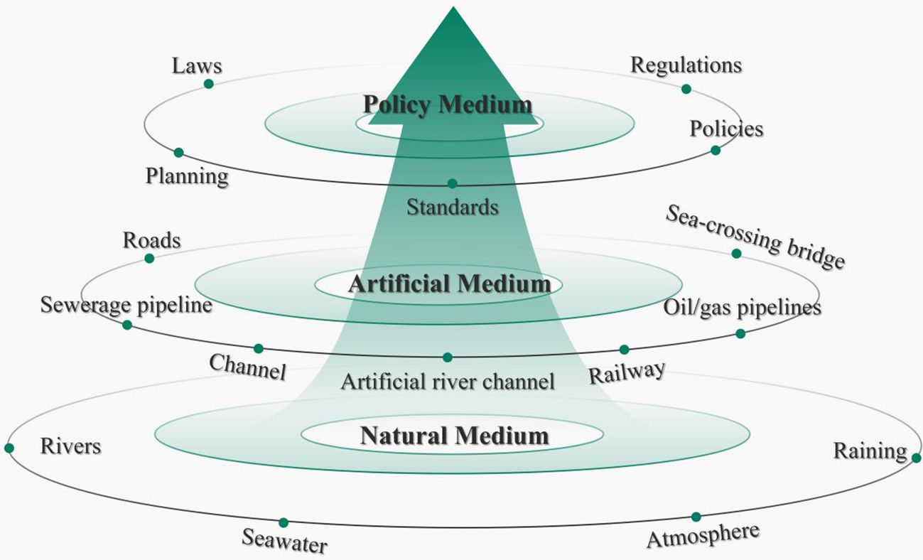
Figure 2 Types of mediating conditions for interregional externalities.
2.1.3 Transported substance
The transported substance is the specific elements of matter, energy, and information taken by different medium. Under normal conditions, the type and quantity of transported substance are in a relatively stable state. When there is a sudden change in the amount or type of transported substance, it can easily lead to the movement of the transported substance across the region, thus creating the phenomenon of interregional externalities. This sudden change is usually caused by the subject region and is also a trigger for changes in the receptor region.
2.2 The fit between the interregional externality theory and LSC
The land and the sea are both independent of each other and closely linked, with very different functional positioning, development needs and resource and environmental carrying capacities. Land and marine ecosystems have established a dynamic equilibrium system over long-term evolutionary processes, facilitated by the circulation of materials and energy flows. Within the ecological carrying capacity, land and sea spaces can foster a synergistic relationship. Marine environments, rich in untapped resources, complement the resource diversity of land space, thereby mitigating land resource scarcity. Conversely, advanced technologies, systems, and human capital from terrestrial domains can contribute to the sustainable development and utilization of marine environments. When land space and sea space are viewed as distinct domains of interest, a competitive relationship between land space and sea space becomes apparent. This competition manifests across multiple dimensions including spatial development trajectories, resource utilization, ecological conservation, environmental governance, and other facets. In practice, LSI includes both interactions based on natural processes (e.g., sediment transport in rivers, storm surges, saltwater intrusion, etc.) and interactions dominated by human activities (e.g., pollutant discharges to the sea, construction of coastal projects, ecological protection and restoration of coastal zones, etc.). More complexly, the above interactions processes between land and sea are intertwined, integrated and mutually influential, together shaping the natural environment and economic and social patterns of the coastal zone area (Shown as Figure 3). LSI are not only vertical linkages between land space and sea space, but also imply horizontal linkages between different types of space within land or sea space (Li et al., 2021). Furthermore, the interaction between land space and sea space is marked by the simultaneous presence of both positive and negative externalities, which requires systematic consideration of the natural processes and the economic development between the land and the sea, as well as harmonized management on that basis. Therefore, the study of LSC should not be limited to the interaction of the two spatial geographic units of land and sea, but should also take into account the interaction of different types of space within the independent space of land or sea.
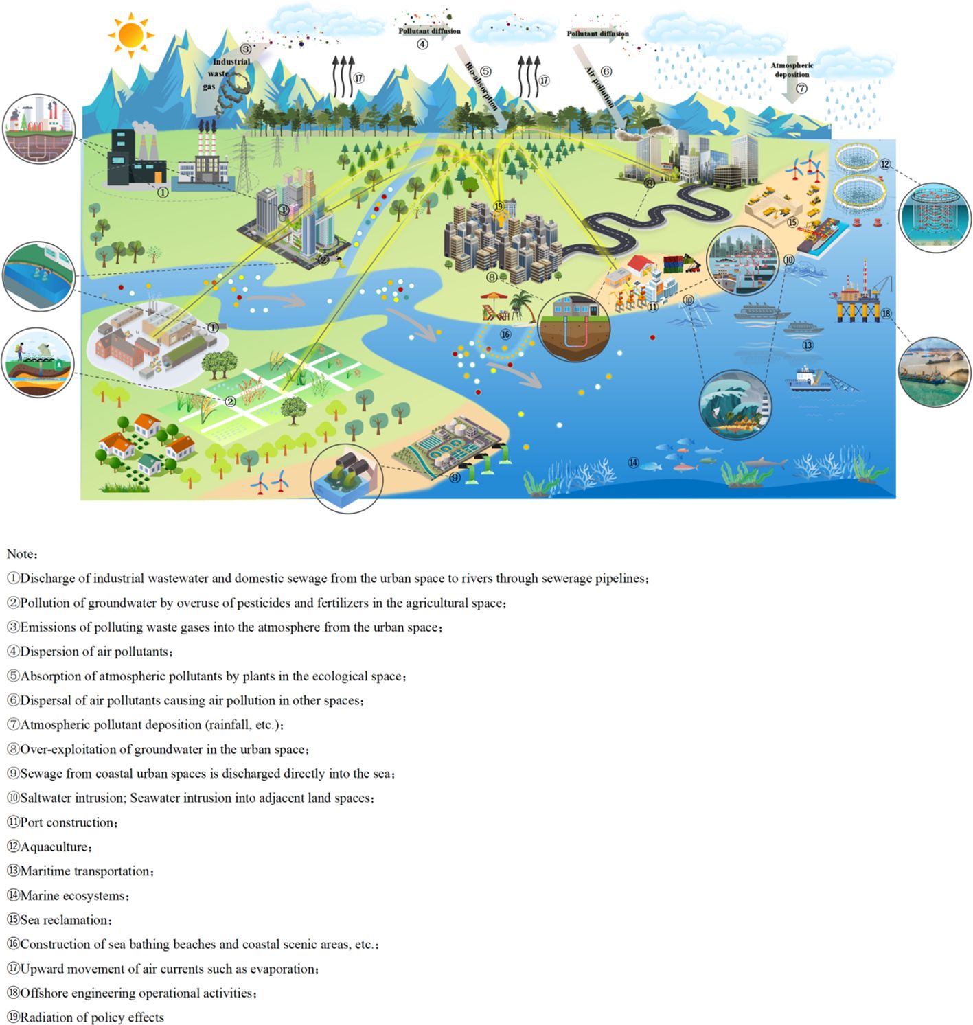
Figure 3 Typical manifestations of LSI.
Intra-regional externalities and inter-regional externalities characterize LSI at different spatial scales, respectively. Intra-regional externalities are mainly concerned with the dynamic relationship between various types of spatial utilization activities and the natural environment at the micro scale, which is the cause of spatial interactions. Inter-regional externalities are concerned with the effects of different functional spatial units at the meso-scale on the one hand, and between land and sea at the macro-scale on the other hand (Shown as Figure 4). This coincides with the need for research on different spatial scales and different types of spatial activities for China’s territorial spatial planning.
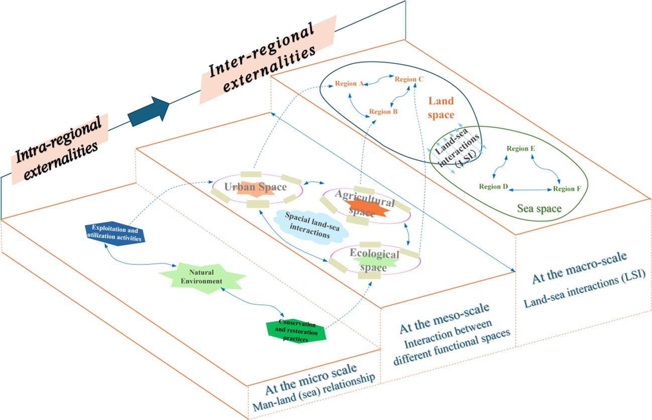
Figure 4 LSI at different spatial scales.
Therefore, the interregional externality theory can provide an effective research paradigm for land and sea integrated territorial spatial planning, so as to avoid planning research being limited to a single process and a single scale. Under the framework of the interregional externality theory, analyzing the issue from the perspectives of spatial linkages, medium conditions and transported substance between the subject and receptor regions will help to clarify the process of LSI and their manifestations. This contributes to a holistic understanding of the causes and processes of the phenomenon of interregional externalities between land and sea, and leading to a deeper understanding of the key demands and tasks of China’s LSC policy.
3 Delineation of spatial units and analysis of spatial interactions
Combined with the previous analysis, to explore LSC based on the interregional externality theory, it is necessary not only to consider the effects of spatial utilization activities within the region on the natural environment at the micro-scale, but also to fully explore the process of interactions and their characteristics between different spatial types at the meso-scale, and to analyze the pattern and form of LSI at the macro-scale on this basis. Therefore, the rational division of spatial units is the basic premise for analyzing LSI. Combined with the practice of territorial spatial planning, this study firstly delineates the two first-level spatial units of land space and sea space at the macro scale. At the meso-scale, land space is divided into three types of second-level spatial units, namely, agricultural space, land ecological space and urban space, and sea space is divided into two types of second-level spatial units, namely, marine ecological space and marine exploitation space (consisting of fishery space, industrial, mining and communications space, transportation space, recreational space, special sea-use space, etc.). At the micro-scale, this study focuses on the characteristics of man-land or man-sea relations in the implementation of various types of spatial activities.
China’s LSC policy is mainly applied to cross-regional resource and environmental issues (especially the interregional externalities of land-sea junction zones), and since the forms, intensity, elements, subjects and impacts of utilization activities vary, it is difficult to fully clarify the LSI by the enumeration method alone. China’s LSC policy is characterized by its global and comprehensive characteristics. Starting from a systemic thinking will help to better clarify the manifestation of intra-regional externalities and the formation process of interregional externalities in each spatial unit. Reconceptualizing the complex spatial utilization activities occurring within land space and sea space as interactions among various spatial units enhances the precision of interpreting the essence of the LSC policy. This study applies the concept of system dynamics and uses Vensim software to create a flow diagram that illustrates the dynamics of LSI. By integrating the components of the Vensim flow diagram with the characteristics, of each spatial unit, including functions, intra-regional externaltities or interregional externaltities, we aim to uncover the key factors influencing the man-land (sea) relationship, and to simplify the complex interactions between these spatial units. (Shown as Table 1). The analysis reveals that intra- and inter-regional externalities are intertwined, interdependent and mutually constraining, forming an intricate spatial interaction between land space and sea space (Shown as Figure 5).
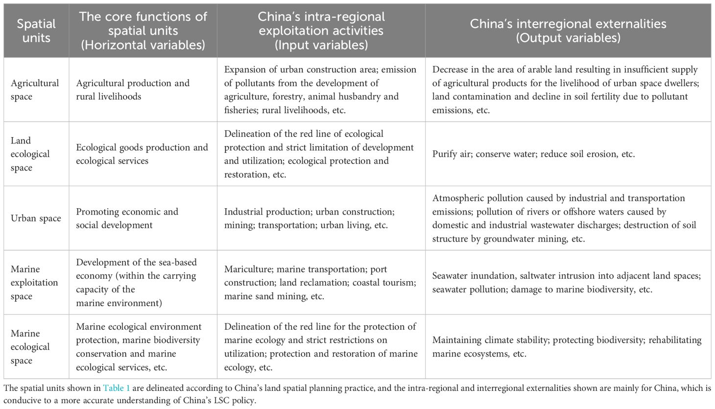
Table 1 Analysis of LSI in China based on Vensim system flow diagrams.
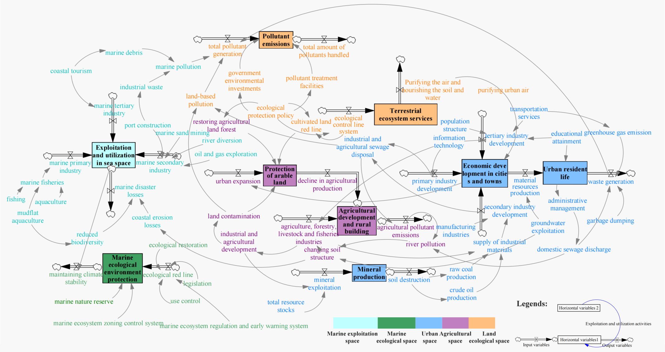
Figure 5 System dynamics flow diagrams for land space and sea space utilization activities.
3.1 Land spatial units
3.1.1 Agricultural space
Agricultural space includes subdivided unit types such as rural development space and farmland protection space. Agricultural space has multi-dimensional functions such as arable land protection, agricultural development, farmers’ life and modern rural construction. Through agricultural production activities such as cultivation of arable land, animal husbandry, freshwater aquaculture, and development of economic forests, the development of primary industries such as agriculture, forestry, animal husbandry, and fisheries can contribute to the sustained supply of agricultural products needed for the daily lives of human beings and other organisms from agricultural space to other spatial units, thus creating PIE. At the same time, the excessive use of pesticides, fertilizers and chemicals will cause land pollution and a decline in soil fertility in the agricultural space, thus creating negative intra-regional externalities. This part of agricultural pollutants will be discharged into the neighboring rivers and aquifers, and eventually pollutants will be transported to the sea space, forming NIE.
3.1.2 Land ecological space
Land ecological space includes subdivided unit types such as ecological protection space and ecological control space. Land ecological space is used to protect terrestrial space with special important ecological functions or ecological sensitivity and fragility, as well as the need to preserve the original form and strengthen ecological conservation. Within the land ecological space, through afforestation, pollutant emission control, ecological restoration and the construction of nature reserves, it is possible to restore and protect land natural areas with special important ecological functions or ecologically sensitive and fragile areas in this space. These measures can keep terrestrial ecosystems in a relatively stable state, further exerting their functions of water and soil conservation and air purification, and creating positive intra-regional externalities. Moreover, land ecological space can continuously deliver ecological products and services to other spatial units through surface runoff and atmospheric movement, promoting the improvement of ecological environment quality in other spatial units and forming PIE.
3.1.3 Urban space
The urban space has economic and social development as its core function, and is a centralized area for industrial agglomeration, energy development and population movement. Within the urban space, various types of human development and utilization activities to promote the economic development of towns and cities can be categorized as the development of primary, secondary and tertiary industries. The development of these three major industries creates a steady flow of material resources for urban residents to support the normal functioning of human society and the upgrading of urban development. However, this process also generates a large amount of waste such as domestic garbage, industrial solid waste, greenhouse gases, industrial sewage, etc., which damages the ecological environment of the city and the livable space for the residents, thus creating negative intra-regional externalities. When the total amount of waste exceeds the maximum capacity of the urban pollutant treatment system, the pollutants will be transported to the sea space along with atmospheric deposition and river movement, causing pollution of the near-shore environment and destruction of coastal landscapes, thus forming NIE.
3.2 Sea spatial units
3.2.1 Marine exploitation space
Marine exploitation space is an important area for the development of the marine-based economy, carrying multiple uses such as seawater aquaculture, marine transportation, industrial and mining exploitation, and leisure and recreation. Within the maximum carrying capacity of the marine environment, the utilization of marine resources can provide a supply of resources and space for the development of land space when land-based resources are close to being scarce. At the same time, space utilization activities for ocean development and exploitation can be carried out more efficiently owing to the advantages of land space, such as advanced technology, mature planning policies and strong financial resources. As a result, the land and sea economies interact positively, creating positive intra-regional externalities. However, if the scale and intensity of the use of the sea area continue to expand, it will cause serious damage to the marine ecological environment, thus forming negative interregional externalities. Marine pollutants will cause varying degrees of disturbance to coastal land space through natural processes such as seawater movement and atmospheric deposition, creating NIE.
3.2.2 Marine ecological space
Marine ecological space consists of marine ecological protection space and marine ecological control space. It is used to protect marine spaces that have ecological functions of special importance or are ecologically sensitive and vulnerable, and that require preservation and enhanced ecological conservation. Within the marine ecological space, to prevent irreversible deterioration of the marine ecological environment as a result of the increased intensity of human utilization activities and the excessive discharge of pollutants through the delineation of a red line for the protection of marine ecology, and to further protect marine biodiversity. Damaged marine ecosystems can be restored through the establishment of marine nature reserves, the implementation of ecological restoration, and the strengthening of marine ecosystem regulation and early warning capabilities, thereby preventing and mitigating marine environmental disasters and environmental accidents, harmonizing the relationship between marine utilization activities and marine environmental protection, then creating positive externalities within marine ecological space areas. Further, actively exploiting the effective role of marine ecosystems in stabilizing the climate and sequestering and reducing carbon can improve the climate environment in both land and sea space at a macro-scale level, forming PIE.
4 Integrated analysis of interregional externalities in coastal zones
4.1 Characterization of interregional externalities in coastal zone
Combined with the results of the analysis of the system dynamics flow diagram, it can be seen that different spatial units interact with each other through various types of medium to form PIE or NIE, which are characterized as follows:
4.1.1 Diversification of land space and sea space utilization activities
There are significant differences between land space and sea space in terms of natural environment, material composition, spatial structure, etc. Combined with Figure 4, it can be found that the interregional externalities of land space and sea space have different manifestations in terms of resources, ecology, environment, industry, etc., which directly leads to the diversified characteristics of the utilization activities of land space and sea space. The forms of space utilization activities have diversified characteristics. Since the coastal zones are the main area of frequent material exchange and energy flow between land space and sea space, and utilization activities with different intensities, natures and types are carried out there. The object of spatial planning includes both the various types of space utilization activities and the spatial carriers of these activities and natural elements. This means that exploring LSI from the perspective of territorial spatial planning requires comprehensive consideration of the spatial linkages between land-sea natural processes and human activities.
4.1.2 Coexisting positive and negative externalities in space utilization activities
Land space and sea space have different functional positions and interest orientations. For different space units, the same space utilization activity may have both positive and negative externalities. When the functional orientation of a space unit is compatible with the purpose of a space utilization activity, the space utilization activity creates a positive externality for the space unit, and vice versa, a negative externality. For example, land reclamation can have PIE for urban space by allowing them to expand their land area without incurring additional costs. However, land reclamation imposes unrecoverable costs on marine ecological space, thus creating NIE in marine ecological space.
4.1.3 Interregional externalities are directional
Depending on the direction of factor movement, interregional externalities take the form of unidirectional or bidirectional. An interregional externalities is bidirectional if the subject region affects the receptor region while at the same time responding to changes in the receptor region. Conversely, if the subject region will not be disturbed by the receptor region, the interregional externalities is expressed as unidirectional. For example, the formation process of land-based sources of pollution is a unidirectional process, where the subject region is the urban space and agricultural space, and the receptor area is the ocean space. In contrast, the interaction between land-based industries and marine-based industries is a two-way process, with marine-based industries being both subject and receptor regions, as is the case with land-based industries.
4.1.4 Difficulty in attributing responsibility for externality effects
In general, administrative boundaries, functional area boundaries and geographical boundaries do not overlap. Physical geographic processes often span multiple administrative units or functional area types. This leads to an inability to accurately define the attribution of responsibility for externality effects when interregional externalities occur. For example, when pollution from socio-economic activities in land space spreads to sea space, it is often not the land space alone that bears the responsibility for pollution management, but the sea space also has to bear the huge cost of environmental management.
4.2 Manifestations of interregional externalities in coastal zone
Interregional externalities are essentially the existence of uninterrupted exchanges of various elements between spatial units, such as matter, energy, information, etc., which are transmitted through different types of medium. Therefore, this study classifies interregional externalities into three forms of factors flowing, materials transferring and policy radiation based on medium characteristics (Shown as Figure 6 and Table 2).
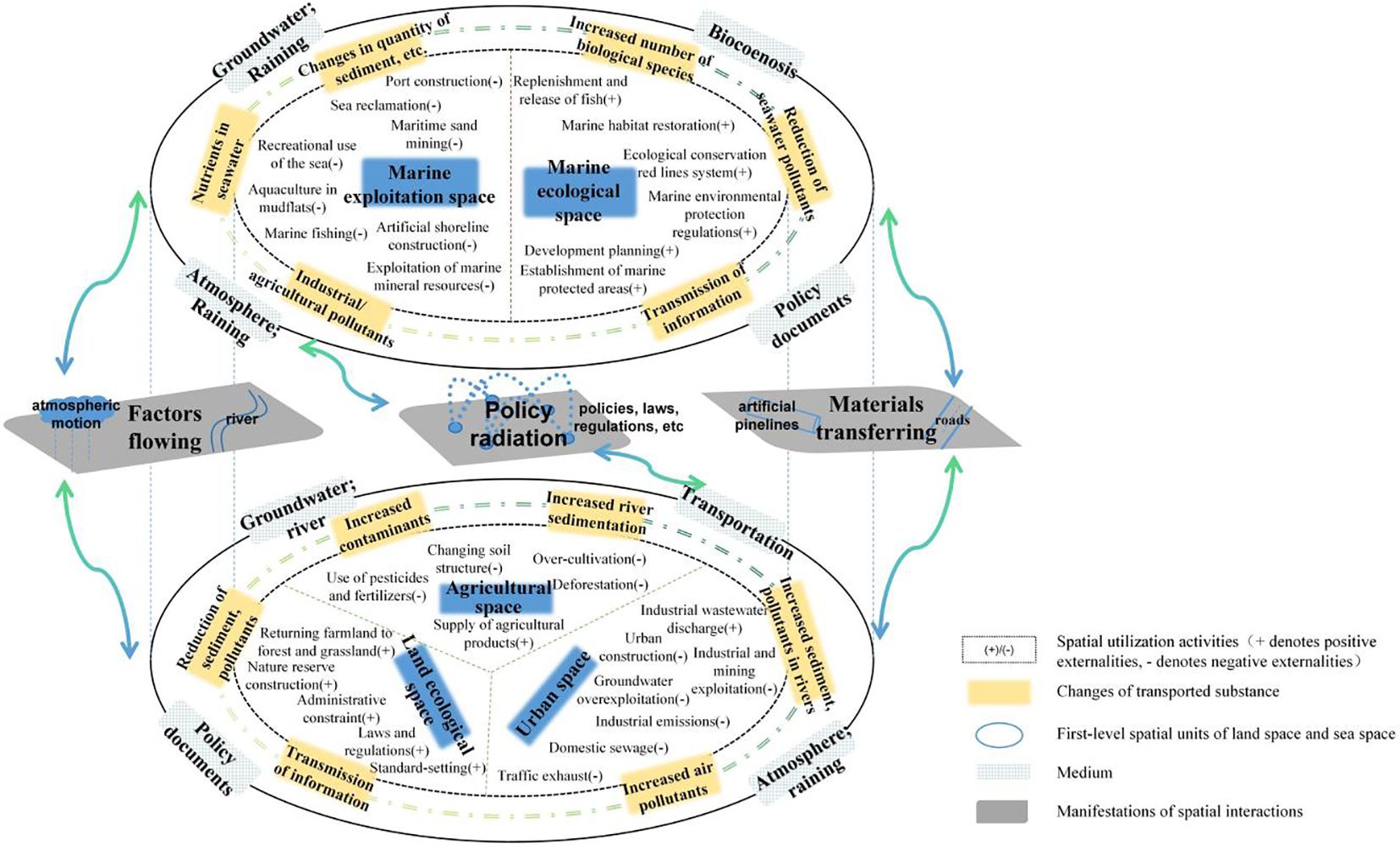
Figure 6 Typical manifestations of LSI.
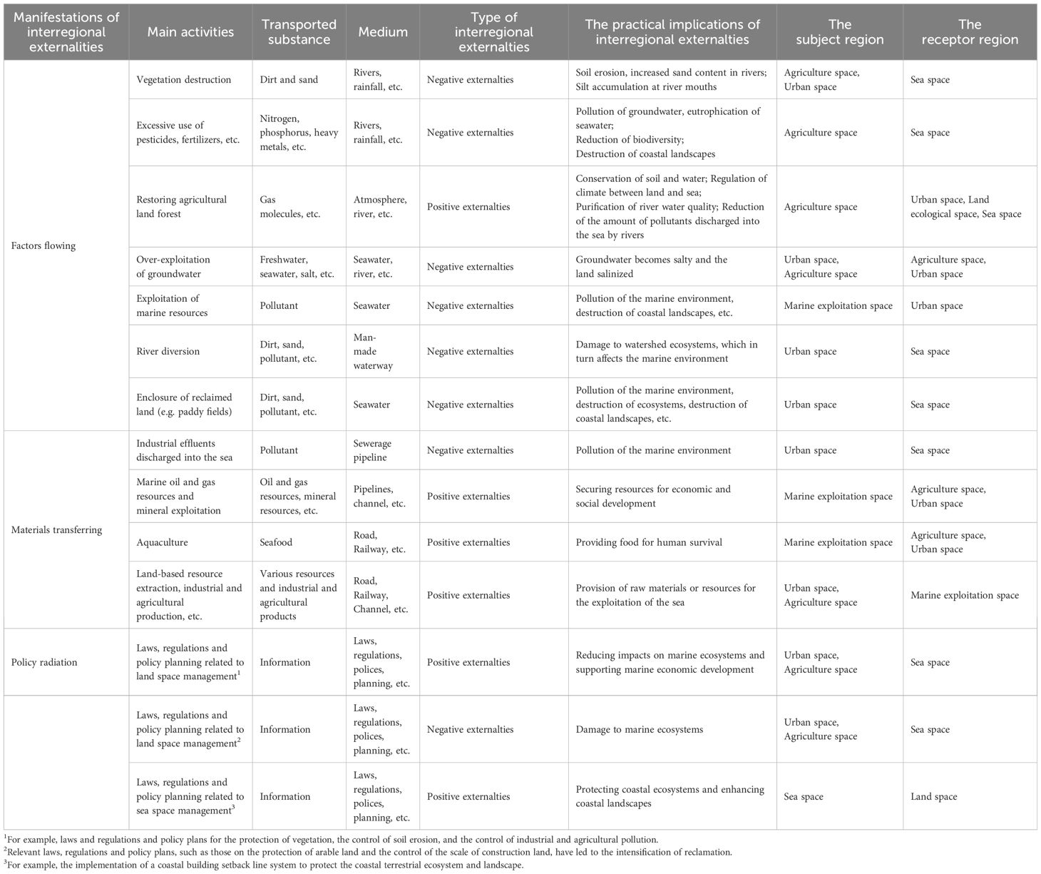
Table 2 Main processes of LSI.
4.2.1 Factors flowing
Factors flowing is the interactions between land space and sea space through natural medium. Common forms of factor flows in land and sea space include the atmospheric cycle, the water cycle, etc. The above processes are mediated by natural processes such as rivers, atmosphere, precipitation, etc., which cause spillovers of intra-region externalities generated in the land (sea) space to the sea (land) space. For example, the excessive use of fertilizers in agricultural space will cause some nitrogen and phosphorus compounds to be discharged into the sea with rivers or rainwater, resulting in eutrophication of sea water and red tides, and ultimately creating NIE. Planting trees in the ecological space enables a large number of tree species to produce a large amount of oxygen through photosynthesis, and the surplus oxygen in the ecological space spills over to the surrounding urban space, thus greatly improving the air quality of the urban space and forming PIE.
4.2.2 Materials transferring
Materials transferring is the interactions between land space and sea space through artificial medium. Common forms of materials transferring include the transportation of goods through transportation infrastructure such as railroads, roads, ports, etc., or the discharge of sewage and the transport of oil and gas resources through pipelines, etc. Land and marine transportation infrastructure together constitute a comprehensive three-dimensional transportation network, which greatly promotes the extension of the marine-based industry chain to the land, forming a clear trend of land and marine industry linkage. This allows regions that are not directly adjacent to each other in terms of geographic location to transfer spatial effects across regions without the need for the natural medium. It not only accelerates the transformation of intraregional externalities into interregional externalities, but also makes the form of interactions between spatial units more complex. The construction of various sewage pipes also enables pollutants in urban space to be easily transferred to the sea space, resulting in marine ecological pollution and the formation of NIE.
4.2.3 Policy radiation
Policy radiation is the interactions between land space and sea space through the policy medium of laws, regulations, policies, plans, etc. Policy changes within a region may alter the goals, direction and mode of spatial development of this region, which in turn may have spatial effects on other regions through natural or artificial medium. For example, with the increasing scarcity of land resources, the Chinese government has imposed strict controls on arable land resources, strictly controlling the area of arable land that has been converted to construction land. In this context, in order to expand development space, coastal areas acquire land resources through reclamation and other means, thus causing serious harm to the marine resources and environment, which is reflected in NIE. Another example is that the Chinese government has implemented a policy of great protection for the Yangtze River, strictly controlling the discharge of sewage from industries along the river. This initiative has resulted in a significant reduction in the total amount of pollutants entering the sea, which has effectively protected the marine environment and is reflected in PIE.
5 Land-sea coordination policy: conceptual framework and implementation pathway
5.1 The conceptual framework of the LSC
There are differences between land space and sea space due to differences in interest needs and goal orientation. Individuals with relevant interests located in the coastal zone diverge in their choices of economic development and ecological protection, leading to the formation of various forms of interregional externalities in terms of resources, ecology, environment and industry. Under the framework of the interregional externatilities theory, this study argues that LSC is about harmonizing the functions and development objectives of different spatial units. Treating land and sea as a unified regional system makes it possible to regard issues of land-sea conflict as an internal problem of the complex system of coastal zones. While weakening the heterogeneity between land space and sea space in terms of natural geographic features, management systems, development and utilization modes, etc., it fully coordinates the demands of the two different types of subjects, the land space and the ocean space, in terms of ecological protection and economic development. Only in this way will it be conducive to the realization of the integrated coordination of land and marine space utilization activities and protection. Within the theoretical framework of economics, internalization emerges as a pivotal approach to address the challenges posed by externalities. Two broad categories of methods are usually included: The first is the government-driven “Pegu method” through the imposition of sewage and environmental taxes. The second is the “Coase method”, which is dominated by market forces through the definition of property rights and the differentiation of interests. Ecological protection focuses on government control, while economic development emphasizes market mechanisms. Therefore, to promote the LSC, it is necessary to make comprehensive use of the “Pegu method” and the “Coase method”. It requires to integrate the comparative advantages of land and sea resources and to take into account the specific interests and needs of land and sea when they are different subjects from a more macro and systematic perspective.
The essence of interregional externalities is that the subject region relies on the medium to transmit the transported substance, which enters the receptor region and thus affects the receptor region positively or negatively. Based on this premise, the implementation of LSC can start from source control, process control and interaction interface control. Increase the depth of LSC by enhancing the PIE and weakening the NIE.
5.1.1 Source control: control of the total amount of substances exported from the subject region
The transported substance is direct factors that can cause externality effects. Therefore, strengthening source control can restrict the total amount of substances exported from the subject region. For inter-district positive externality effects, the material output of the subject region can be further strengthened. For PIE effects, the total amount of transported substance exported by the subject region should be further increased. For example, the development of the land-based economy requires various products generated by the marine economy, and the supply of marine products can be increased moderately within the carrying capacity of the marine environment to better support the high-quality development of the land-based economy. For NIE effects, consideration should be given to reducing the total amount of substance exported by the subject region. For example, a variety of pollutants generated by industrial production and the lives of urban residents in land space units enter the sea space through rivers, pipelines, etc., which are an important source of marine pollution. Therefore, the generation of pollutants from land-based sources and their transport processes should be controlled at source in order to further reduce the level of pollution of the marine environment by pollutants.
5.1.2 Process control: optimizing the medium’s transportation of substances
The medium is the vehicle through which different spatial units interact. The direction, intensity and manifestation of LSI can be effectively regulated through scientific adjustment of medium conditions. Specifically including:
1. Reduced intervention in natural medium. In the process of LSI, natural medium such as rivers, atmosphere and rainfall play a key role in shaping the topography, geomorphology and ecosystems of the coastal zone, profoundly affecting the near-shore marine environment and ultimately influencing the economic and social development of coastal zones.
2. Improvement of artificial medium. Improving the construction of artificial medium, such as roads, railroads and oil and gas pipelines, can further strengthen the links between different spatial units and thus improve the efficiency of resource transportation. The construction of sewage pipelines has also accelerated the pollution of rivers and oceans, making near-shore waters a catchment area for pollutants in a short period of time. Therefore, in territorial spatial planning, on the one hand, the spatial layout of artificial medium such as transportation infrastructure should be optimized to give full play to its articulation and enhance its positive externality effects. On the other hand, it is also necessary to reasonably control the construction of artificial medium such as sewage pipelines and reduce its negative externality effects.
3. Enhancing the systemic nature of the policy medium. Land and sea management policies are often characterized by contradictory and conflicting regimes, as different laws apply to land and sea space. Therefore, policy regimes for coastal zones should be systematic. It is important to consider the coastal zone space as a whole and to avoid “losing sight of the big picture”. This means that one spatial element cannot be protected at the expense of others.
5.1.3 Interaction interface control: strengthening the overall control of LSI regions
The coastal zone is the area with the strongest land-sea interaction, where various types of positive and negative externalities are formed, which profoundly affect the ecological environment and economic and social development of the region. Therefore, effective coordination of various types of spatial conflicts and the promotion of benign interaction between land and sea are the basic starting points for spatial governance in the region. LSI are characterized by complexity and diversity, which requires the formulation of relevant planning policies to take into account comprehensively such spatial activities as resource utilization, disaster prevention, industrial development, ecological protection, environmental governance and the enhancement of the human habitat. On the one hand, the internal coordination of the different functional units should be strengthened in a unidirectional dimension in conjunction with land and sea spatial units. For example, in addition to considering the utilization of resources in the fishery space, it is necessary to strengthen environmental management and landscape control. In addition to considering the needs of port shipping development, port space should also strengthen environmental management, conflicts with other sea utilization activities, and connection with urban transportation. On the other hand, there is also a need to plan the coastal zone as a whole from a comprehensive dimension, to strengthen disaster defense and the protection of sea-friendly space.
5.2 Implementation pathways for the LSC
The formation and development of inter-regional externalities necessarily passes through three stages: the formation of intra-regional externalities in the subject region, spillovers through the medium, and effects on the receptor region. Therefore, according to the different stages of the formation of inter-regional externalities, the implementation pathways of LSC can focus on three links: source control, process control and interaction interface control. In conjunction with the relevant requirements and means of territorial spatial planning, the LSC can be implemented in the following ways.
5.2.1 Building an integrated land and sea pattern of territorial space development and protection
The spatial pattern of the subject region, medium and the receptor region determines the form and intensity of interactions between the different regions and profoundly influences the effects of interregional externalities on land and sea. Hence, within the framework of territorial space planning, it is imperative to establish an integrated national spatial development and protection pattern that encompasses both land and sea, aiming to enhance coordination between these two domains and mitigate adverse consequences.
At the macro scale, spatial linkages between land and sea should be systematically considered. Emphasis should be placed on the close relationship between land and sea in terms of economic interaction, resource complementarity, ecological integration, land-based sources of pollution, and the mediums such as rivers and transportation infrastructure that link land and sea. Building upon this foundation, the spatial configuration of land and sea integration can be optimized. This can be achieved through the enhancement of transportation infrastructure, including ports, inland waterways, railroads, and highways. By bolstering these transportation networks, the economic connectivity between land and sea can be strengthened, facilitating the synergistic utilization of terrestrial and marine resources. Furthermore, this will reinforce the economic influence and impetus of coastal regions on inland areas, fostering greater economic radiation and spillover effects.
At the meso scale, the development objectives of each type of space and its effect on other spaces are considered in an integrated manner. On the basis of scientific evaluation, agricultural space, land ecological space, urban space, marine ecological space, and marine exploitation space should be rationally delineated. Conflicts between the three types of agricultural space, land ecological space and urban spaces should be reduced, thus promoting the harmonization of land-based economic and social development with ecological protection and arable land conservation. The spillover of intra-regional externalities such as agricultural pollution and soil erosion into ocean space should be further curbed, thereby reducing the problem of negative interregional externalities such as seawater pollution and damage to marine biodiversity.
At the micro scale, unified control of spatially adjacent and closely linked land and marine spatial units in the coastal zone. Firstly, it is recommended to designate natural ecosystems such as mangrove forests, salt marshes, and estuaries, which span both land and sea, as cohesive ecological protection units. This approach facilitates the integrated implementation of land-sea ecological preservation, control, and restoration measures. Secondly, spatially contiguous regions that involve closely linked land-based and marine activities, such as port waters, shorelines, and their corresponding terrestrial areas, can be identified as comprehensive development and utilization units. This designation enables the harmonization of spatial arrangements for land-based and marine development activities, optimizing spatial functions and providing essential support for the growth of the marine-based industry.
5.2.2 To settle land by sea: strengthening coastal zone ecological environment protection, restoration and management
The degradation of coastal zone ecosystems and the decline in the quality of the marine environment are long-term challenges to the economic and social development of the coastal zone. The vulnerability of coastal zone ecosystems, subjected to multifaceted pressures from both terrestrial and marine domains, is undeniably apparent. Simultaneously, these ecosystems play a crucial role in providing ecological services to both land and sea space, thereby enhancing overall spatial quality. Consequently, prioritizing the protection of coastal zone ecosystems and implementing comprehensive marine environmental management emerge as imperative tasks within the context of the LSC.
Firstly, typical ecosystems such as mangrove forests and seagrass beds will be assigned to the red line of ecological protection for strict protection, so as to ensure that the ecological function, area and nature of the coastal zone will not be reduced or altered. Strengthening the resilience of coastal zone ecosystems in the face of climate change, marine disasters, and human spatial utilization activities is of paramount importance.
Secondly, systematic protection of intertidal ecosystems with strong land-sea interactions is needed. Elevating the spatial access threshold is crucial to prevent intrusive development and construction activities from encroaching upon vital coastal zones, including bedrock intertidal zones, sandy intertidal zones, silty intertidal zones, and biological intertidal zones. By safeguarding these intertidal habitats, particularly those crucial for migratory bird species, the protection of intertidal biodiversity can be effectively upheld.
Thirdly, strengthening the control and management of all types of land-based pollutants. Stringent regulation of sewage discharge into rivers and coastal waters via sewage pipes, while ensuring compliance with established standards, is imperative. In cases where the quality of seawater in bays falls below the prescribed standards, emission reduction measures are implemented within river catchment areas and coastal zones to progressively restore the seawater quality.
Fourthly, enhancing the overall restoration of coastal zone ecosystems. Regarding compromised natural shorelines, the restoration of ecological functions can be achieved through the removal of sea-enclosure farming facilities and the ecological transformation of seawalls. In the case of damaged coastal wetlands, a combination of natural and artificial restoration approaches will be employed. For severely fragmented and functionally degraded natural wetlands, a comprehensive restoration strategy will be implemented, encompassing silt removal, dredging, topographical and geomorphological restoration, shoreline maintenance, aquatic vegetation restoration, habitat construction, and other appropriate measures to gradually reinstate the ecological functions of the wetlands.
5.2.3 Optimizing the industrial layout along the river and the coast
Relying on the advantages in transportation, resources and opening up to the outside world, riverine and coastal areas are often areas of industrial concentration. While this promotes the development of industrial clusters, it also puts heavy pressure on the marine environment. Therefore, the relationship between the development of land-based and marine-based industry and environmental protection should be harmonized in territorial spatial planning. Firstly, a stringent control mechanism should be implemented to prevent non-water-dependent industries from occupying valuable shoreline resources. This measure aims to safeguard the natural shoreline and establish high-quality sea-friendly areas accessible to the public. Secondly, the establishment of highly polluting and energy-consuming industries along rivers and coastlines must be strictly prohibited. Additionally, direct discharge of sewage into rivers and the sea should be strictly forbidden, accompanied by intensified environmental monitoring of river outlets and near-shore waters. These measures are crucial for enhancing the near-shore marine environment’s quality. Thirdly, there is a need for effective coordination of sea use requirements across different industries. This entails promoting the offshore and deep-water development of traditional aquaculture and offshore energy sectors, while also reducing the development intensity of offshore waters. Fourthly, the integration of tourism with mariculture and offshore wind power should be encouraged, allowing tourism activities to extend seaward. Furthermore, implementing robust land space governance policies is essential to safeguard the construction of land-based supporting facilities required by marine industries, ultimately raising the standard of marine economic development.
5.2.4 Implementation of integrated coastal zone management
Coastal zones are the areas where the LSI is the strongest, so the realization of the LSC requires the implementation of integrated land-sea management for coastal zones. First, the scope of the coastal zone should be rationally delineated. At present, there are various forms of delineation of the scope of the coastal zone, including specific distances, geographic indications, administrative units, etc. This study argues that the scope of the coastal zone should not be too large, and suggests that the scope of the coastal zone be delineated from the perspective of spatial control in order to implement strict use control measures. In practice, key objectives such as marine disaster defense, environmental pollution control, ecological environmental protection, and protection of sea-friendly space can be considered comprehensively. The scope of the coastal zone should be comprehensively delineated in conjunction with the first coastal highway, the typical ecosystem boundary of the coastal zone, the land area of the port and other geographic landmarks or the current status of spatial development, and the scope should not be too large.
On the basis of the delineation of the extent of the coastal zone, it is appropriate to implement a strict use control system, taking into account the key challenges facing the integration of land and sea. For example, in response to the disappearance of natural shorelines, damage to typical ecosystems and encroachment on seafaring space, coastal building retreat lines can be delineated, and the control of the use of land space in the coastal zone can be strengthened to reduce the disturbance of land space in the coastal zone caused by human activities. In response to the problem of serious pollution of near-shore waters, seawater farming and livestock farming in coastal areas should be strictly controlled, the construction of outfalls should be scientifically justified, and marine environmental governance should be strengthened.
Moreover, when formulating coastal zone planning and implementing corresponding measures, it is essential to adhere to a systemic and holistic approach. This necessitates avoiding the narrow focus on singular spatial elements or specific activities while disregarding the comprehensive impacts of various development and utilization endeavors. Consequently, throughout the planning and implementation stages, active engagement and guidance should be provided to involve relevant departments responsible for natural resources, marine affairs, transportation, ecological environment, agriculture and rural areas, as well as tourism-related sea management. This concerted effort aims to enhance policy coordination among these diverse departments, fostering a cohesive and integrated approach.
6 Conclusion and research prospectives
Based on the interregional externality theory, this study discusses the manifestation and formation mechanism of the LSI, and further explores the basic concept and specific paths for implementing the LSC. Firstly, this study introduces the interregional externality theory from the traditional economic concept of externality, and clarifies the necessary conditions for the formation of inter-regional externalities and their fit with the LSC based on the perspective of regional spatial interaction. Secondly, to elucidate the impacts of spatial utilization activities on the natural environment within the region at the micro-scale and investigate the progression of intra-regional externalities into interregional externalities at the meso-scale, this study delineates the fundamental units of land and sea space. In accordance with the principles of territorial spatial planning, the paper meticulously examines the spatial activities occurring within distinct types of spatial units and explores the intricate process of spatial interaction between land and sea. Thirdly, from the interregional externality theory, this study summarizes and condenses the characteristics of interregional externalities in the coastal zone and the manifestations of land-sea unit interactions. Finally, the planning pathways of the LSC is proposed from the perspective of internalization of interregional externalities. Through the above research process, this paper obtains the following conclusions:
1. The spatial utilization activities in coastal zones have both intra-regional and interregional externalities. These two types of externalities are intertwined, interdependent and mutually constraining, forming an intricate spatial interaction between land space and sea space. Among them, intra-regional externalities are mainly concerned with the dynamic relationship between various types of spatial activities and the natural environment at the micro scale. Interregional externalities pertain to the consequences arising from the intricate interplay among diverse functional units at the meso scale. Simultaneously, these externalities encompass the dynamic interactions occurring between land and sea at the macro scale. This fits precisely with the research needs of territorial spatial planning for different spatial scales and different types of spatial activities.
2. The formation of interregional externalities in coastal zones requires the fulfillment of three conditions: regional correlation, medium conditions and transported substance. The interregional externalities can be classified into three forms of factors flowing, materials transferring and policy radiation based on medium characteristics.
3. The basic ideas of realizing the LSC is to focus on source control, process control and interaction interface control, so as to enhance the positive interregional externality effect and weakening the negative interregional externality effect. This specifically includes: Source control is implemented to regulate the overall quantity of material exported from the subject region; Process control is employed to optimize the transport functions of the media involved. Interaction interface control is undertaken to enhance comprehensive management over land-sea interaction zones.
4. In conjunction with the relevant requirements and means of territorial spatial planning, the LSC can be implemented in the following ways: Building an integrated land and sea pattern of territorial space development and protection; Strengthening coastal zone ecological environment protection, restoration and management; Optimizing the industrial layout along the river and the coast; Implementation of integrated coastal zone management.
Developing a well-developed interregional externality theory could significantly enhance both the theoretical framework and practical applications of LSC and LSI research in China. This paper theoretically aligns the concept of interregional externalities with LSC studies and initially establishes an analytical framework to apply this theory to LSC-related issues. However, there remain gaps in the quantitative analysis of interregional externalities and in practical case studies, which suggest avenues for further refinement and expansion of this theory in the future.
Data availability statement
The original contributions presented in the study are included in the article/supplementary material. Further inquiries can be directed to the corresponding author.
Author contributions
YL: Conceptualization, Formal analysis, Funding acquisition, Methodology, Resources, Supervision, Writing – original draft, Writing – review & editing. YW: Conceptualization, Formal analysis, Methodology, Software, Visualization, Writing – original draft. DL: Conceptualization, Methodology, Resources, Writing – review & editing. YH: Conceptualization, Formal analysis, Writing – review & editing.
Funding
The author(s) declare financial support was received for the research, authorship, and/or publication of this article. This work was supported by National Key Research and Development Plan (Grant No. 2022YFC3800801) and the National Natural Science Fund of China (NO. 42306247).
Conflict of interest
The authors declare that the research was conducted in the absence of any commercial or financial relationships that could be construed as a potential conflict of interest.
Publisher’s note
All claims expressed in this article are solely those of the authors and do not necessarily represent those of their affiliated organizations, or those of the publisher, the editors and the reviewers. Any product that may be evaluated in this article, or claim that may be made by its manufacturer, is not guaranteed or endorsed by the publisher.
References
Bagella M., Becchetti L., Cicero M. (2004). Regional externalities and direct effect of legislation against money laundering: A test on excess money balance in the five Andean countries. J. Money Laund. Contro. 7, 347–366. doi: 10.1108/13685200410810056
Baker S., Constant N., Nicol P. (2023). Oceans justice: trade-offs between sustainable development goals in the Seychelles. Mar. Pol. 147, 105357. doi: 10.1016/j.marpol.2022.105357
Brooks K., Barclay K., Grafton R. Q., Gollan N. (2022). Transforming coastal and marine management: Deliberative democracy and integrated management in New South Wales, Australia. Mar. Pol. 139, 104053. doi: 10.1016/j.marpol.2020.104053
Caviedes V., Arenas-Granados P., Barragán-Munoz J. (2020). Regional public policy for Integrated Coastal Zone Management in Central America. Ocean Coast. Manage. 186, 105114. doi: 10.1016/j.ocecoaman.2020.105114
Chen J., Kang S., Wu A., Chen L. (2024). Projected emissions and climateimpacts of Arctic shipping along the Northern Sea Route. Environ. Pollut. 341, 122848. doi: 10.1016/j.envpol.2023.122848
Duan X., Yu X., Lu D., Nipper J. (2010). The study of new economic geography of Krugman and its significance. Acta Geogr. Sin. 65, 131–138. doi: 10.11821/xb201002001
Guan X., Liu W., Chen M. (2016). Study on the ecological compensation standard for river basin water environment based on total pollutants control. Ecol. Indic. 69, 446–452. doi: 10.1016/j.ecolind.2016.05.011
Guggisberg S. (2024). Finding equitable solutions to the land-based sources of marine plastic pollution: Sovereignty as a double-edged sword. Mar. Pol. 159, 105960. doi: 10.1016/j.marpol.2023.105960
Halpern B., Ebert C., Kappel C., Madin E., Micheli F., Perry M., et al. (2009). Global priority areas for incorporating land-sea connections in marine conservation. Conserv. Lett. 2, (4). doi: 10.1111/j.1755-263X.2009.00060.x
Han F., Ke S. (2013). Spatial externalities, comparative advantage and manufacturing agglomeration. J. Quant. Technol. Econ. 30, 22–38+116. doi: 10.13653/j.cnki.jqte.2013.01.012
Han L., Li D. (2015). Blue food system: cuarantee of China’s food security. Agric. Econ. 36, 24–29+110. doi: 10.13246/j.cnki.iae.2015.01.005
Hsieh P., Li Y. (2009). A cluster perspective of the development of the deep ocean water industry. Ocean Coast. Manage. 52, 287–293. doi: 10.1016/j.ocecoaman.2009.03.006
Hua T., He L., Jiang Q., Chou L., Xu Z., Yao Y., et al. (2024). Spatio-temporal coupling analysis and tipping points detection of China’s coastal integrated land-human activity-ocean system. Sci. Total Environ. 914, 169981. doi: 10.1016/j.scitotenv.2024.169981
Huang J., Li Q., Tu Z., Pan C., Zhang L., Ndokoye P., et al. (2013). Quantifying land-based pollutant loads in coastal area with sparse data: Methodology and application in China. Ocean Coast. Manage. 81, 14–28. doi: 10.1016/j.ocecoaman.2012.07.011
Jung P., Thill J. (2022). Sea-land interdependence and delimitation of port hinterland foreland structures in the international transportation system. J. Trans. Geogr. 99, 103297. doi: 10.1016/j.jtrangeo.2022.103297
Khelil N., Larid M., Grimes S., Berre I., Peuziat I. (2019). Challenges and opportunities in promoting integrated coastal zone management in Algeria: Demonstration from the Algiers coast. Ocean Coast. Manage. 168, 185–196. doi: 10.1016/j.ocecoaman.2018.11.001
Li J., Tian P., Li C., Gong H. (2022). Land-sea economic relations and land space utilization based on land-sea coordination: Research status, problems and future priorities. J. Nat. Resour. 37, 924–941. doi: 10.11821/dlyj020200397
Li K., He J., Li J., Guo Q., Liang S., Li Y., et al. (2018). Linking water quality with the total pollutant load control management for nitrogen in Jiaozhou Bay, China. China. Ecol. Indic. 85, 57–66. doi: 10.1016/j.ecolind.2017.10.019
Li Y., Liu D., Luo T. (2021). The internal logic and developing direction of land-sea coordination in land space planning: from the perspective of complex system theory. Geogr. Res. 40, 1902–1916. doi: 10.11821/dlyj020200397
Lu D. (2011). The methodology of human economic geography and its characteristics. Geogr. Res. 30, 387–396. doi: 10.11821/yj2011030001
Lu M., Chen Y., Lu Y. (2018). The competition and cooperation spatial pattern between railway transport and shipping in China under the Belt and Road Initiative. Geogr. Res. 37, 404–418. doi: 10.11821/dlyj201802013
Makino A., Beger M., Klein C., Jupiter S., Possingham H. (2013). Integrated planning for land-sea ecosystem connectivity to protect coral reefs. Biol. Conserv. 165, 35–42. doi: 10.1016/j.biocon.2013.05.027
Matear R., Wang Y. (2010). Andrew Lenton. Land and ocean nutrient and carbon cycle interactions. Curr. Opin. Environ. Sustain. 2, 258–263. doi: 10.1016/j.cosust.2010.05.009
Mejjad N., Rossi A., Pavel A. (2022). The coastal tourism industry in the Mediterranean:A critical review of the socio-economic and environmental pressures & impacts. Tour. Manage. Perspect. 44, 101007. doi: 10.1016/j.tmp.2022.101007
Ngoran S., Xue X. (2015). Addressing urban sprawl in Douala, Cameroon: Lessons from Xiamen integrated coastal management. J. Urb. Manage. 4, 53–72. doi: 10.1016/j.jum.2015.05.001
Ni Y., Du P., Chen H. (2024). Enhancing blue: The resilience of blue economy and the efficiency of China’s sea-land industrial synergy. Technol. Forecast. Soc Change. 198, 123007. doi: 10.1016/j.techfore.2023.123007
Pantusa D., Saponieri A., Tomasicchio G. (2023). Assessment of coastal vulnerability to land-based sources of pollution and its application in Apulia, Italy. Sci. Total Environ. 886, 163754. doi: 10.1016/j.scitotenv.2023.163754
Pinillos F., Muoz J., Ríos F. (2023). Delimiting coastal zones for integrated management: The case of the island and the sea of Chiloé(Chile). Mar. Pol. 150, 105535. doi: 10.1016/j.marpol.2023.105535
Poulos S., Chronis G., Collins M., Lykousis V. (2000). Thermaikos Gulf Coastal System, NW Aegean Sea: an overview of water/sediment fluxes in relation to air–land–ocean interactions and human activities. J. Mar. Syst. 25, 47–76. doi: 10.1016/S0924-7963(00)00008-7
Qu Y., Wang S., Tian Y., Jiang G., Zhou T., Meng L. (2023). Territorial spatial planning for regional high-quality development-An analytical framework for the identification, mediation and transmission of potential land utilization conflicts in the Yellow River Delta. L. U. Pol. 125, 106462. doi: 10.1016/j.landusepol.2022.106462
Reis J., Stojanovic T., Smith T. (2014). Relevance of systems approaches forimplementing Integrated CoastalZone Management principles in Europe. Mar. Pol. 43, 3–12. doi: 10.1016/j.marpol.2013.03.013
Ren Z., He C., Wang W. (2021). Progress of research on economic complexity and regional economic development in the perspective of evolutionary economic geography. Prog. Geog. 40, 2101–2115. doi: 10.18306/dlkxjz.2021.12.010
Ren W., Xu Y., Ni J. (2024). Evolution of marine ecology-industry symbiosis patterns and ecological security assessment: New evidence from coastal areas of China. Ocean Coast. Manage. 247, 106939. doi: 10.1016/j.ocecoaman.2023.106939
Saeidpour A., Chorzepa M. G., Christian J., Durham S. (2019). Probabilistic hurricane risk analysis of coastal bridges incorporating extreme wave statistics. Eng. Struct. 182, 379–390. doi: 10.1016/j.engstruct.2018.11.069
Smith H., Maes F., Stojanovic T., Ballinger R. (2011). The integration of land and marine spatial planning. J. Coast. Conserv. 15, 291–303. doi: 10.1007/s11852-010-0098-z
Stouffer S. (1940). Intervening opportunities: A theory relating mobility to distance. Am. Sociol. Rev. 5, 845–867. doi: 10.2307/2084520
Sunley P. (2008). Relational economic geography: A partial understanding or a new paradigm. Econ. Geogr. 84, 1–26. doi: 10.1111/j.1944-8287.2008.tb00389.x
Turner J., Essex S. (2016). Integrated terrestrial and marine planning in England’s coastal inter-tidal zone: assessing the operational effectiveness of the Coastal Concordat. Mar. Pol. 72, 166–175. doi: 10.1016/j.marpol.2016.07.014
Vanclay F. (2012). The potential application of social impact assessment in integrated coastal zone management. Ocean Coast. Manage. 68, 149–156. doi: 10.1016/j.ocecoaman.2012.05.016
Wilkinson W., Leeks G., Morris A., Walling D. (1997). Rivers and coastal research in the Land Ocean Interaction Study. Sci. Total Environ. 194-195, 0–14. doi: 10.1016/S0048-9697(96)05350-8
Yao L., Yue B., Pan W., Zhu Z. (2023). A framework for identifying multiscenario priorities based on SCP theory to promote the implementation of municipal territorial ecological conservation planning policy in China. Ecol. Indic. 155, 111057. doi: 10.1016/j.ecolind.2023.111057
Zaucha J., Conides A., Klaoudatos D., Noren K. (2016). Can the ecosystem services concept help in enhancing the resilience of land-sea social-ecological systems? Ocean Coast. Manage. 124, 33–41. doi: 10.1016/j.ocecoaman.2016.01.015
Zaucha J., Jay S. (2022). The extension of marine spatial planning to the management of the world ocean, especially areas beyond national jurisdiction. Mar. Pol. 144, 105218. doi: 10.1016/j.marpol.2022.105218
Zhang R., Dai J., Bai Y., Barone D., Hill-Beaton L. (2023). Risk-based transportation infrastructure management: An integrated framework and case study in USVI against coastal flood and sea level rise. Ocean Coast. Manage. 242, 106723. doi: 10.1016/j.ocecoaman.2023.106723
Appendix 1 Criteria for determining “positive impact effects” and “negative impact effects”
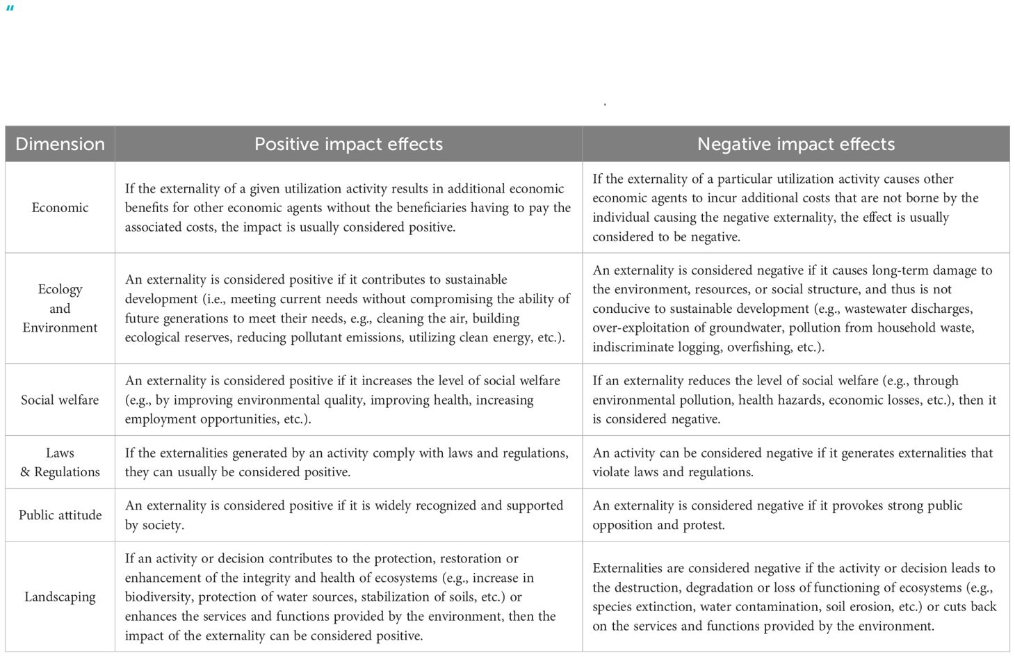
Table A.1 Criteria for determining “positive impact effects” and “negative impact effects”.
Keywords: interregional externality, China’s land-sea coordination (LSC), land-sea interactions (LSI), connotation analysis, path discussion
Citation: Li Y, Wang Y, Liu D and Hou Y (2024) Connotation analysis and path discussion of China’s land-sea coordination policy: based on the interregional externality theory. Front. Mar. Sci. 11:1405157. doi: 10.3389/fmars.2024.1405157
Received: 22 March 2024; Accepted: 15 July 2024;
Published: 29 July 2024.
Edited by:
Mehran Idris Khan, University of International Business and Economics, ChinaReviewed by:
Zafar Ullah, Lasbela University of Agriculture, Water and Marine Sciences, PakistanChao Fan, Zhejiang Ocean University, China
Copyright © 2024 Li, Wang, Liu and Hou. This is an open-access article distributed under the terms of the Creative Commons Attribution License (CC BY). The use, distribution or reproduction in other forums is permitted, provided the original author(s) and the copyright owner(s) are credited and that the original publication in this journal is cited, in accordance with accepted academic practice. No use, distribution or reproduction is permitted which does not comply with these terms.
*Correspondence: Dahai Liu, liudahai@fio.org.cn