 Bo Cheng
 Xiudi Zhu
 Juha M. Alatalo
 Jessica Gordon4
- 1Changjiang Water Resources Protection Institute, Wuhan, China
- 2Key Laboratory of Ecological Regulation of Non-Point Source Pollution in Lake and Reservoir Water Sources, Changjiang Water Resources Commission, Wuhan, China
- 3Environmental Science Center, Qatar University, Doha, Qatar
- 4California-China Climate Institute, University of California, Berkeley, Berkeley, CA, United States
The distribution and composition of wetland habitats for wintering waterbirds are heavily influenced by water level fluctuations. Through polder construction and aquaculture activities, paddy fields and aquaculture ponds have decreased the lateral connectivity of water level fluctuations in the lake. However, the impacts of water level fluctuations on habitat suitability, which can be seen using high-resolution images analysis, often cannot separate disturbances caused by the paddy fields and aquaculture ponds, and it is difficult to capture the actual impact of water level fluctuations on wetland habitats. Based on remote sensing image data and hydrological data, we selected Caizi Lake as a study site and comparatively analyzed the changes in wintering waterbird habitats in a water level sequence under the two scenarios. Our work showed that paddy fields and aquaculture ponds should be considered as potential options for creating more suitable habitats for migratory waterbirds if combined with reasonable and effective management of the water level within the paddy fields and aquaculture ponds. The present study results could facilitate the management and sustainable utilization of Caizi Lake wetlands and provide support for creating small habitats by managing the water levels of paddy fields and aquaculture ponds.
1 Introduction
Wetlands provide many ecosystem services, such as providing material resources, reducing water pollution, controlling floods, and drought, and mitigating climate change; in addition, wetlands are of great significance to maintaining species diversity, especially for wintering waterbirds (An et al., 2007; Mitsch and Gosselink, 2015). As a typical wetland type (Wu and Zheng, 2020), floodplain wetlands create the ecotone between the terrestrial and aquatic with plenty of wetland vegetation and hydrological rhythm (Wang et al., 2013; Li et al., 2019c; Qiu et al., 2021). The middle and lower Yangtze River floodplain, which provides important wintering habitats for waterbirds on the East Asian-Australian flyway, is one of the most concentrated areas of freshwater lakes in China (Chen et al., 2011; An et al., 2021). Over the past half-century, wide scale and high density of aquaculture and agriculture resulted in lake degeneration, and creating paddy fields and aquaculture ponds. However, within the last decade, a series of wetland protection and restoration policies have been imposed on floodplain lakes along the Yangtze River, for example, recovering lakes by stopping land reclamation, and a ban on pen-culture and fishing (Zhao et al., 2019; Xie et al., 2022; Ye et al., 2022). Furthermore, appropriate action is needed to explore the utilization of the historic paddy fields and aquaculture ponds for waterbird conservation and wetland management.
The distribution and composition of lake wetlands, specifically wetland plant communities, are heavily influenced by water level fluctuations (Wilcox, 2004; Geis, 2018). Water levels determine the type and availability of habitats by impacting food resources and shelter vegetation for waterbirds (Holm and Clausen, 2006; Faragó and Hangya, 2012; Jahanbakhsh Ganjeh et al., 2017; Jing et al., 2017; Liang et al., 2022). Hence, water levels in wetlands are crucial for species diversity and the composition of wintering waterbirds (Zhang et al., 2018a; Hohman et al., 2021). At present, the research on the water level fluctuations affecting lake wetlands have mainly focused on habitat suitability for migratory birds using high-resolution images (Wang et al., 2018a; Wu et al., 2021; Zhu et al., 2021). For example, Wang et al. (2018a) found that the habitat area of mudflats and herbaceous marshes was significantly negatively correlated with the water level of Caizi Lake during the overwintering period; Wu et al. (2021) revealed the responses of habitat suitability for migratory birds to increased water level during the middle of the dry season in Dongting Lake and Poyang Lake; Zhu et al. (2021) found that water level changes the habitat suitability of migratory birds by changing vegetation distribution at different elevations in East Dongting Lake.
However, through polder construction and aquaculture activities, paddy fields and aquaculture ponds have decreased the lateral connectivity in the natural state of the lake, which destroyed water level fluctuation rules during autumn and winter that water levels in paddy fields and aquaculture ponds are inconsistent with the lake area. Consequently, remote sensing image analysis often cannot separate disturbances caused by the paddy fields and aquaculture ponds, and it is difficult to capture the actual impact of water level fluctuations on wetland habitats. Moreover, some studies have reported that paddy fields and aquaculture ponds can provide wintering waterbirds with substitute habitats (Zheng et al., 2015; Wang et al., 2020; Liang et al., 2022). Therefore, investigating how water level fluctuations caused by paddy fields and aquaculture ponds influence the available habitats for wintering waterbirds is crucial for quantifying the actual impacts on lake wetlands and also essential for effective policymaking to support waterbird habitat management.
Caizi Lake, located in the middle and lower reaches of the Yangtze River floodplain, is not only an important wintering habitat and stopover site for migratory waterbirds along the East Asian-Australasian Flyway (Chen et al., 2011), but is also a regulation and storage lake for the Yangtze-to-Huaihe Water Diversion (YHWD) Project (An et al., 2021). Since the 1950s, when arable land in the region became limited, villagers living around Caizi Lake used polders to build paddy fields in the lake (Zhu and Zhou, 2010). After the 1980s, fisheries in Caizi Lake transformed from wild fishing resources to managed stock-enhanced fish (pen aquaculture) (Jiang et al., 2018; Wang et al., 2020). As a result, 70%–80% of the lake body is now divided into polyculture pools of paddy fields and aquaculture ponds by temporary soil dams (Chen et al., 2011).
Based on remote sensing image data and hydrological data, this paper selected Caizi Lake as a study site and comparatively analyzed the changes in wintering waterbird habitats in a water level sequence under two scenarios: Scenario 1 (the current situation) and Scenario 2 (the habitat management situation). The present study results could facilitate the management and sustainable utilization of lake wetlands and provide support for the suggestion that small habitats should be created by managing the water levels of paddy fields and aquaculture ponds through the YHWD project. This paper aims to present a framework for identifying the impacts of water level fluctuations on wetland habitats and providing directions for ecological restoration of lake wetlands that are greatly affected by human disturbance through the optimal management of water levels within paddy fields and aquaculture ponds.
2 Materials and methods
2.1 Study area
Caizi Lake (117°01′–117°10′E, 30°43′–30°58′N), located in the southeast of Dabie Mountain and the north branch of the Yangtze River, is subject to a north subtropical humid monsoon climate (An et al., 2021). Caizi Lake was naturally connected to the Yangtze River, with a total area of 300 km2 at the end of the 1950s (Wang et al., 2018a). The lake became a reservoir lake after the Zongyang Sluice was built in 1959, providing conditions for the utilizing of wetland resources. The lake’s water level is highest in July and August (the average water levels in July and August were 9.33 m and 10.90 m according to the daily water level data collected by Chefuling station from 1989 to 2018), begins to drop gradually in September (the average water levels in September was 9.26 m), and rises again gradually in March (the average water levels in September was 7.11 m). In the wet season, the water level of Caizi Lake peaks at 14.88 m (Huanghai Datum), with a water surface area of 242.9 km2; In the dry season, the lake water level drops to 8.1 m (Huanghai Datum), with a water surface area of 145.2 km2 (Wang et al., 2018b).
Caizi Lake provides important wintering habitats for migratory waterbirds that arrive in October and depart from late March to early April. According to historical survey data, there are more than 40 waterbird species and at least 20,000 waterbirds that winter on the lake (Wang et al., 2018a). Some waterbird species are globally threatened and are listed on the IUCN (the International Union for Conservation of Nature) Red List, such as the Siberian Crane (Grus leucogeranus), Oriental White Stork (Ciconia boyciana), Hooded Crane (Grus monacha) and Swan goose (Anser cygnoides) (Zhu and Zhou, 2010).
The YHWD project is an inter-basin water transfer project, that moving water from the Yangtze River to the Huaihe River. Caizi Lake is a vital channel for the YHWD Project as it undertakes 60% of the total water diversion and more than 85% of the gravity diversion from the Yangtze River (Wang et al., 2018a). According to the YHWD Project plan, by 2030 and 2040, the water level at Caizi Lake will be artificially increased by 0.52 m and 1.12 m, respectively, compared with the lake’s current annual average water level during the migratory waterbird overwintering period (Wang et al., 2018a). The expected hydrological changes may negatively affect the exposure of primary habitats, such as meadows, mudflats and shallow water, used by wintering waterbirds at Caizi Lake (Wang et al., 2018a; Li et al., 2019a).
2.2 Analytical framework for the differentiation of the impacts of water level fluctuations on wintering waterbird habitats under different scenarios
The framework used for quantifying how water level fluctuations caused by paddy fields and aquaculture ponds influence the available habitats for wintering waterbirds is mainly comprised of four stages (Figure 1): 1) data preparation, using a long time series of water level data and high-resolution remote sensing images; 2) extraction of paddy field and aquaculture pond data; 3) measuring of the impacts of water level fluctuations on wintering waterbird habitats under different scenarios, involving definitions of scenarios, interpretation of lake wetlands with different water levels, formulation of the ways the main waterbird habitats respond to water level; 4) stating the implications for habitat management and conservation.
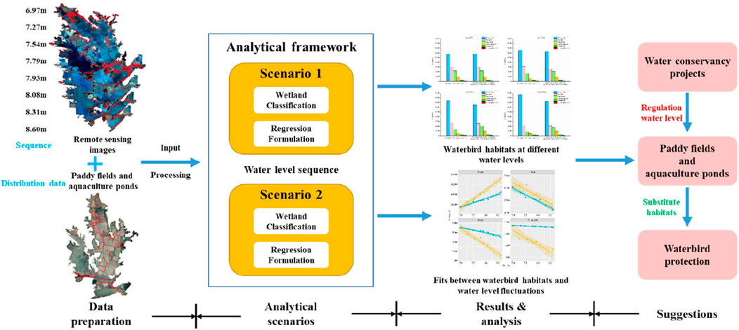
FIGURE 1. Analytical framework for the differentiation of the impacts of water level fluctuations on wintering waterbird habitats under different scenarios.
2.2.1 Data requirement and preparation
2.2.1.1 Collection of water level data
The water level data in this paper is the average daily water level data provided by the Chefulin Monitoring Hydrological Station. Chefulin Station is the only water level station in the lake area, representing the overall hydrological situation of Caizi Lake. The station’s daily average water level data from 1956 to 2018 was collected and turned into Huanghai Datum data.
2.2.1.2 Classification of wetland habitats
We downloaded cloud-free Level 1T Landsat TM/ETM+/OLI images (path/row: 121/39) from the USGS website (https://earthexplorer.usgs.gov/) covering the study area. These images were selected for the wetland habitat classification shown below. This paper used Envi 5.3.1 software for image pre-processing, such as band synthesis, radiation calibration, atmospheric correction, and geometric correction. Then, all the images were classified into six major wetland types (Zhang et al., 2019), including water body, mudflat, grassland, cultivated land, woodland and construction land, using the Iterative Self-Organizing Data Analysis Technique (ISODATA). Among the six categories that constituted the Caizi Lake, grassland, mudflat, cultivated land and water body were the main wetland habitats of wintering waterbirds, providing food resources and habitats for these fish-eating waterbirds, invertebrate-eating waterbirds, tuber-eating waterbirds, sedge-eating waterbirds and seed-eating waterbirds (Fang et al., 2020; Wang, 2020). Finally, the overall classification accuracies and Kappa chance correction statistics were used for the classification accuracy assessment. The value of the total classification accuracy is more than 90% and the Kappa coefficients are greater than 0.8, which meet the requirements.
2.2.2 Extraction of paddy fields and aquaculture ponds data
The primary industry development is the main economic livelihood for populations living in Caizi Lake, and the lake plays a vital role in local fisheries and agriculture. The growth of the agriculture and aquaculture industry led to the transformation of large areas of lake wetlands into paddy fields and aquaculture ponds, reaching 90% of the lake area (Gao et al., 2011; Wang et al., 2018b). Using the high-resolution remote sensing satellite image data from Google Maps in May 2016, the distribution of paddy fields and aquaculture ponds was extracted using visual interpretation combined with a field survey, as shown in Figure 2.

FIGURE 2. Distribution of paddy fields and aquaculture ponds in the Caizi Lake area.
2.2.3 Impacts of water level fluctuations on wintering waterbird habitats under different scenarios
2.2.3.1 Definitions of scenarios
Paddy fields and aquaculture ponds have been cut off from the lake due to the reclamation activities of farmland and inland fisheries. The isolation causes the differences in water level fluctuations between paddy fields and aquaculture ponds and the lake that can affect the composition and distribution of wetlands. To investigate the impacts of paddy fields and aquaculture ponds on wintering waterbird habitats, the following two scenarios were selected:
Scenario 1- the current situation: a scenario where wetland habitats were interpreted using remote sensing images based on spectral, texture and shape features.
Scenario 2- the habitat management situation: a scenario where the distribution and composition of wetland habitats remain unchanged within paddy fields and aquaculture ponds as the water level rises until water levels in paddy fields and aquaculture ponds are consistent with the lake open area.
Under the two scenarios, the changing trends of lake wetlands with water levels were interpreted and the dynamic responses of the main waterbird habitats to water levels were formulated.
2.2.3.2 Interpretation of lake wetlands at different water levels
This paper classified the wetland types in Caizi Lake based on remote sensing images of different water levels. According to the analysis of long-term water level data at the Chefuling Water Level Station from 1956 to 2018, the multi-year average water level of Caizi Lake is 8.55 ± 0.43 m, and the multi-year average water level of Caizi Lake during the migration period is 7.01 ± 0.37 m. To better fit the relationship between the water level and waterbird habitats, the water levels on the acquisition days of the selected images ranged from 6.9 m to 8.6 m, with intervals as even as possible. A total of eight high-quality Landsat TM/ETM+/OLI images were selected, matching the water level data, as shown in Table 1.
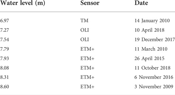
TABLE 1. Basic information on the remote sensing images of the Caizi Lake area.
2.2.3.3 Formulation of main waterbird habitats responding to water level
Using SPSS 16.0 software, we used regression models to formulate the dynamic responses of the main waterbird habitats, namely water body, mudflat, grassland and cultivated land, to water level. The value of determination R-Square (R2), ranged from 0 to 1, goodness-of-fit statistics were used to measure how well the regression model fits the data (Allen, 1997).
3 Results
3.1 Wintering waterbird habitats at different water levels under two scenarios
3.1.1 Scenario 1- the current situation
Table 2 gives the change statistics for all types of lake wetland at different water levels. Table 3 lists the statistics of the rates of change in the wetland areas at different water levels under Scenario 1 (the current situation). Water body area was shown to increase with the water levels, accounting for the largest proportion of Caizi Lake wetlands at various water levels. Mudflat area exhibited a temporal change with increasing then decreasing tendencies with the rise in the water levels. The areas of cultivated land and grassland consistently decreased, but their rates of change revealed a general fluctuating trend. The woodland and construction land areas showed a similar downward trend with water levels.

TABLE 2. Changes in the wetlands area at different water levels (Scenario 1).
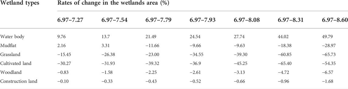
TABLE 3. Rates of change in the wetlands area at different water levels (Scenario 1).
3.1.2 Scenario 2- the habitat management situation
Tables 4, 5 present the changes in area and rates of change across wetland types at different water levels in Scenario 2 (the habitat management situation). The water body area in Caizi Lake generally increased steadily, whereas the areas of mudflat, cultivated land, grassland, woodland and construction land decreased as the water level rose.
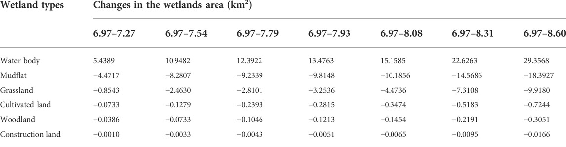
TABLE 4. Changes in the wetlands area at different water levels (Scenario 2).
TABLE 5. Rates of change in the wetlands area at different water levels (Scenario 2).
3.1.3 Comparative analysis of the two scenarios
As shown in Figure 3, we classified Caizi Lake wetland into six categories, including water body, mudflat, grassland, cultivated land, woodland, and construction land, based on the remote sensing images for different water levels under the two scenarios. When the lake water level is 6.97 m, the areas of Caizi Lake wetlands were the same in the two scenarios. In Scenario 1 (the current situation), as the water level rose, the water body area remained larger; the area of mudflat increased from 6.97 m to 7.54 m, decreased in 7.79 m, then increased from 7.93 m to 8.08 m, finally decreased from 8.31 m to 8.60 m; the area of grassland decreased from 6.97 m to 7.54 m, increased in 7.79 m, finally decreased from 7.93 m to 8.60 m; the area of cultivated land decreased from 6.97 m to 7.79 m, increased in 7.93 m, finally decreased from 8.08 m to 8.60 m. In Scenario 2 (the habitat management situation), as the water level rose, the water body area expanded, and the areas of mudflat, grassland and cultivated land showed an opposite trend to the water level. When the water level rose, the woodland and construction land areas continued to decrease in both scenarios.
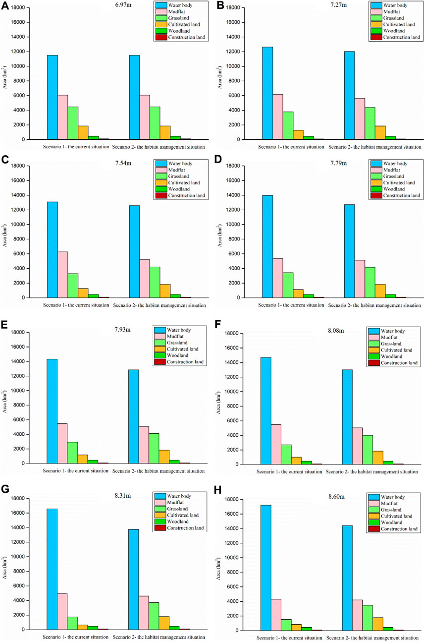
FIGURE 3. The classifications of Caizi Lake wetland at different water levels in the two scenarios. (A) 6.97 m, (B) 7.27 m, (C) 7.54 m, (D) 7.79 m, (E) 7.93 m, (F) 8.08 m, (G) 8.31 m, (H) 8.60 m.
3.2 Response of wintering waterbird habitats to water level changes under different scenarios
3.2.1 Scenario 1- the current situation
Under Scenario 1, the water body area had a significant positive linear correlation with the water level (y = 3503.75x–13120.48, R2 = 0.963, F = 156.500, p = 0.000). The areas of mudflat (y = −32.65x3 + 4822.53x–16407.44, R2 = 0.913, F = 26.385, p = 0.002), grassland (y = −1769.42x + 16800.97, R2 = 0.937, F = 89.519, p = 0.000) and cultivated land (y = 261.51x2–4667.04x + 21580.93, R2 = 0.861, F = 15.490, p = 0.007) showed a similar negative correlation with the water level. Compared with grassland, the mudflat and cultivated land areas were calculated from a second-degree polynomial fit.
3.2.2 Scenario 2- the habitat management situation
Under Scenario 2, there was a significant positive linear correlation between the water body area and the water level (y = 1665.34x–141.85, R2 = 0.957, F = 132.457, p = 0.000). Meanwhile, the areas of mudflat (y = −1021.29x + 13096.97, R2 = 0.958, F = 138.501, p = 0.000), grassland (y = −582.42x + 8621.05, R2 = 0.908, F = 59.087, p = 0.000) and cultivated land (y = −43.08x + 2158.69, R2 = 0.937, F = 89.149, p = 0.000) were linearly and negatively correlated with the water level, and the values of determination R-Square (R2) were over 0.90.
3.2.3 Comparative analysis of the two scenarios
Figure 4 presented the fits between the four types of main waterbird habitats and water level fluctuations in Caizi Lake in two scenarios. We could see that the area of the four main waterbird habitats fit well with the water level. As the water level rose, Scenario 2 had a lower increase in water body area than Scenario 1. As a result, the area of the other three main waterbird habitats showed a lower decrease in water level. The difference between the two scenarios was more evident in grassland and cultivated land.
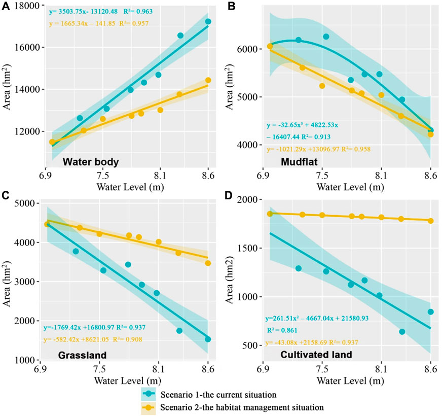
FIGURE 4. The fits between the four types of main waterbird habitats and water level fluctuations at Caizi Lake in the two scenarios. (A) Water body. (B) Mudflat. (C) Grassland. (D) Cultivated land.
4 Discussion
4.1 Water level changes influence wintering waterbird habitats
Our results showed that the habitat area of wintering waterbirds at Caizi Lake was significantly correlated with the water level. The relationship between water level and habitat area further revealed that the lake water level had a significant positive correlation with the water body area and a negative correlation with the area of mudflat, grassland and cultivated land. Similar results have been reported in other studies (Lin et al., 2015; Wang et al., 2018a; Li et al., 2019b), which provided further evidence for the effect of water level on habitat area. Li et al. (2019b) observed that the deep-water areas were significantly positively correlated with the water level at Shengjin Lake, while areas of shallow water, mudflats and grassland were the opposite. Lin et al. (2015) found a highly significant correlation between the area of water body, mudflat and grassland and the water level of Chenglingji in East Dongting Lake.
4.2 Impacts of paddy fields and aquaculture ponds on wintering waterbird habitats
Evaluation of the dynamic responses of main waterbird habitats to the water level in the two scenarios showed that paddy fields and aquaculture ponds affected wintering waterbird habitats at Caizi Lake. As the lake water level rose, there were significant differences between the two scenarios: compared with the Scenario 1 (the current situation), Scenario 2 (the habitat management situation) showed a slower rising trend in the water body area and a lower decrease rate for the other three main waterbird habitat areas. The unique hydrological and geomorphic characteristics of paddy fields and aquaculture ponds surrounded by artificial high levees separated from the lake area of Caizi Lake could increase small areas of wetlands to alleviate the impact of rising water levels on the wintering waterbird habitats, confirming the results of the previous study (Wang et al., 2020; Liang et al., 2022). Wang et al. (2020) suggest that paddy fields and aquaculture ponds can become temporary substitute habitats for wintering waterbirds for relatively short periods. Liang et al. (2022) reported that artificial wetlands, such as paddy fields and aquaculture ponds, can provide waterbirds with substitutes for natural wetlands and shelter in years of food shortage. The effects of paddy fields and aquaculture ponds in this study are roughly similar to the significance of the “dish-shaped lakes” and “cut autumn lakes” in other studies (Hu et al., 2015; Li and Guo, 2017; Zhang et al., 2018b; Liu et al., 2021). The “dish-shaped lakes” and “cut autumn lakes” were also separated from the lake area by artificial dikes. Hu et al. (2015) and Liu et al. (2021) reported that the “dish-shaped lakes” are of great significance to maintaining the stability of the Poyang Lake basin ecosystem and biodiversity. Li and Guo, 2017 and Zhang et al. (2018b) found that the “cut autumn lakes” at Poyang Lake could significantly change the species composition and community biomass of the lake wetland. Hence, utilization of the historic paddy fields and aquaculture ponds is of importance for waterbird conservation and wetland management.
4.3 Implications for wintering bird habitat management and protection
The water level at Caizi Lake will increase by 0.52 m and 1.12 m in the overwintering period in 2030 and 2040 after the YHWD Project is completed (Wang et al., 2018a). Compared to the current situation, over half of the recessional grassland and mudflats are predicted to be lost in winter due to the rise in water level under the proposed YHWD project, reducing habitat availability for a variety of wintering waterbird species (Li et al., 2019a). According to the results of our study, paddy fields and aquaculture ponds can provide waterbirds with substitute habitats. In addition, the areas inside paddy fields and aquaculture ponds are more susceptible to anthropogenic hydrological regulation than the lake area. We suggest to strengthening efforts to effectively regulate the water level within the paddy fields and aquaculture ponds to create more suitable habitats for migratory waterbirds, which can alleviate the impacts of water level rise on the area and distribution of wetland habitat types to a greater extent.
Within the last decade, a series of wetland protection and restoration policies have been imposed on floodplain lakes along the Yangtze River. (Zhao et al., 2019; Xie et al., 2022; Ye et al., 2022). And these policies were carried out in Caizi Lake, including a ban on pen-culture and fishing (Wang, 2020). According to our survey, control sluices were built in the paddy fields and aquaculture ponds. Under the help of the local forest department, the water level within the paddy fields and aquaculture ponds can be managed for creating suitable migratory waterbird habitats.
4.4 Limitations and future research needs
This study explored the water level-wetland habitats relationships underpinning paddy fields and aquaculture ponds. Several limitations encountered in this study provide valuable insights into future research directions for advancing knowledge of how paddy fields and aquaculture ponds influence wintering waterbird habitats. One notable challenge concerns the water level variability across the study area. Although Chefulin Station generally represents the overall hydrological situation of Caizi Lake, the water levels in paddy fields and aquaculture ponds are inconsistent with the lake area due to polder construction. In addition, this is a limitation that directly homogenizes the wetland habitats in the paddy fields and aquaculture ponds.
Another significant challenge is directly linking water level to waterbird diversity. Establishing a long-term continuous and standardized monitoring program in Caizi Lake would help to grasp the spatio-temporal distribution properties of overwintering migratory birds and the growth rhythm of wetland plants. More extensive studies will fill gaps in knowledge around the optimal water level management solutions for paddy fields and aquaculture ponds required for wintering waterbirds in Caizi Lake.
5 Conclusion
Exploring how water level fluctuations caused by paddy fields and aquaculture ponds influence the available habitats for wintering waterbirds is crucial for quantifying the actual impacts on lake wetlands caused by water conservancy projects, and habitat management policymaking to support waterbird conservation. This paper selected Caizi Lake as a study site and comparatively analyzed the changes in wintering waterbird habitats in a water level sequence under the two scenarios. Our results showed that remote sensing image analysis usually exaggerates the impacts of water level fluctuations casued by the operation of water conservancy projects on wetland habitats, and paddy fields and aquaculture ponds could be created as more suitable habitats for migratory waterbirds through reasonable and effective management of the water level within the paddy fields and aquaculture ponds. To reveal the impacts of water level fluctuations caused by paddy fields and aquaculture ponds on the community structure and diversity of waterbirds, we suggest establishing a long-term continuous and standardized monitoring program in Caizi Lake and researching on the coupling mechanism of wetland hydrology and ecology considering water level change, wetland habitat type, and the community structure of waterbirds with different feeding habits.
Data availability statement
The raw data supporting the conclusion of this article will be made available by the authors, without undue reservation.
Author contributions
BC: Methodology, Writing—original draft, review and editing. XZ: Investigation, Visualization. JA: Writing—editing. JG: Writing—editing. HL: Investigation. BJ: Methodology, Writing—review and editing. WY: Methodology, Writing—review, Supervision.
Funding
This research was funded by the National Natural Science Foundation of China (Grant No. U2040210), the Scientific and Technology Project of the Anhui Provincial Group Limited for Yangtze-to-Huaihe Water Diversion (Grant No. YJJH-ZT-ZX-20180404062).
Acknowledgments
We would like to thank Dr. Lesheng An for providing the data of study area figure.
Conflict of interest
The authors declare that the research was conducted in the absence of any commercial or financial relationships that could be construed as a potential conflict of interest.
Publisher’s note
All claims expressed in this article are solely those of the authors and do not necessarily represent those of their affiliated organizations, or those of the publisher, the editors and the reviewers. Any product that may be evaluated in this article, or claim that may be made by its manufacturer, is not guaranteed or endorsed by the publisher.
References
Allen, M. P. (1997). “The coefficient of determination in multiple regression,” in Understanding regression analysis, 91–95.
An, L., Liao, K., Zhu, L., and Zhou, B. (2021). Influence of river-lake isolation on the water level variations of Caizi Lake, lower reach of the Yangtze River. J. Geogr. Sci. 31 (4), 551–564. doi:10.1007/s11442-021-1858-4
An, S., Li, H., Guan, B., Zhou, C., Wang, Z., Deng, Z., et al. (2007). China's natural wetlands: Past problems, current status, and future challenges. AMBIO A J. Hum. Environ. 36 (4), 335–342. doi:10.1579/0044-7447(2007)36[335:cnwppc]2.0.co;2
Chen, J. Y., Zhou, L. Z., Zhou, B., Xu, R. X., Zhu, W. Z., and Xu, W. B. (2011). Seasonal dynamics of wintering waterbirds in two shallow lakes along Yangtze River in Anhui Province. Zool. Res. 32 (5), 540–548. doi:10.3724/SP.J.1141.2011.05540
Fang, L., Dong, B., Wang, C., Yang, F., Cui, Y., Xu, W., et al. (2020). Research on the influence of land use change to habitat of cranes in Shengjin Lake wetland. Environ. Sci. Pollut. Res. 27 (7), 7515–7525. doi:10.1007/s11356-019-07096-5
Faragó, S., and Hangya, K. (2012). Effects of water level on water-bird abundance and diversity along the middle section of the Danube River. Hydrobiologia 697 (1), 15–21. doi:10.1007/s10750-012-1166-1
Gao, P., Zhou, Z., Ma, S., Sun, Q., and Xu, R. (2011). Vegetation distribution pattern and community succession in the transition from macro-phyte-to phytoplankton-dominated state in shallow lakes, a case study of Lake Caizi in Anhui Province. J. Lake Sci. 23 (1), 13–20. (in Chinese). doi:10.18307/2011.0103
Geis, J. W. (2018). “Environmental influences on the distribution and composition of wetlands in the Great Lakes basin,” in Coastal wetlands. Editors H. H. Prince, and M. D. Frank (Boca Raton, FL: CRC Press), 15–31.
Hohman, T. R., Howe, R. W., Tozer, D. C., Giese, E. E. G., Wolf, A. T., Niemi, G. J., et al. (2021). Influence of lake levels on water extent, interspersion, and marsh birds in Great Lakes coastal wetlands. J. Gt. Lakes. Res. 47 (2), 534–545. doi:10.1016/j.jglr.2021.01.006
Holm, T. E., and Clausen, P. (2006). Effects of water level management on autumn staging waterbird and macrophyte diversity in three Danish coastal lagoons. Biodivers. Conserv. 15 (14), 4399–4423. doi:10.1007/s10531-005-4384-2
Hu, Z., Zhang, Z., Liu, Y., Ji, W., and Ge, G. (2015). The function and significance of the Shallow-Lakes in the Poyang Lake wetland ecosystem. Jiangxi Hydraulic Sci. Technol. 41 (05), 317–323. (in Chinese).
Jahanbakhsh Ganjeh, M., Khorasani, N., Morshedi, J., Danehkar, A., and Naderi, M. (2017). Factors influencing abundance and species richness of overwintered waterbirds in parishan international wetland in Iran. Appl. Ecol. Environ. Res. 15 (4), 1565–1579. doi:10.15666/aeer/1504_15651579
Jiang, Z., Xu, N., Liu, B., Zhou, L., Wang, J., Wang, C., et al. (2018). Metal concentrations and risk assessment in water, sediment and economic fish species with various habitat preferences and trophic guilds from Lake Caizi, Southeast China. Ecotoxicol. Environ. Saf. 157, 1–8. doi:10.1016/j.ecoenv.2018.03.078
Jing, L., Lu, C., Xia, Y., Shi, L., Zuo, A., Lei, J., et al. (2017). Effects of hydrological regime on development of Carex wet meadows in East Dongting Lake, a Ramsar Wetland for wintering waterbirds. Sci. Rep. 7 (1), 41761–41769. doi:10.1038/srep41761
Li, C., Li, H., Zhang, Y., Zha, D., Zhao, B., Yang, S., et al. (2019a). Predicting hydrological impacts of the yangtze-to-huaihe water diversion project on habitat availability for wintering waterbirds at Caizi Lake. J. Environ. Manag. 249, 109251. doi:10.1016/j.jenvman.2019.07.022
Li, C., Yang, Y., Wang, Z., Yang, L., Zhang, D., and Zhou, L. (2019b). The relationship between seasonal water level fluctuation and habitat availability for wintering waterbirds at Shengjin Lake, China. Bird. Conserv. Int. 29 (1), 100–114. doi:10.1017/s0959270918000035
Li, Q., and Guo, H. C. (2017). Impact of Poyang Lake water level management through “enclosing sub-Lake in autumn” on lake wetland and its enlightenment. Wetl. Sci. Manag. 13 (03), 27–31. (in Chinese).
Li, Y., Qian, F., Silbernagel, J., and Larson, H. (2019c). Community structure, abundance variation and population trends of waterbirds in relation to water level fluctuation in Poyang Lake. J. Gt. Lakes. Res. 45, 976–985. doi:10.1016/j.jglr.2019.08.002
Liang, W., Lei, J., Ren, B., Cao, R., Yang, Z., Wu, N., et al. (2022). The impacts of a large water transfer project on a waterbird community in the receiving dam: A case study of miyun reservoir, China. Remote Sens. 14 (2), 417. doi:10.3390/rs14020417
Lin, G. J., Li, Z. J., Lei, M. J., Jiang, B., and Yang, Y. Q. (2015). Response of land cover in Dongting Lake to water level change of Yangtze River. Yangtze River 46 (19), 114–118.
Liu, H., Yuan, H., Wang, S., Zheng, L., and Liao, M. (2021). Spatiotemporal dynamics of water body changes and their influencing factors in the seasonal lakes of the Poyang Lake region. Water 13 (11), 1539. doi:10.3390/w13111539
Mitsch, W. J., and Gosselink, J. G. (2015). Wetlands. fifth ed. Hoboken, New Jersey: John Wiley & Sons.
Qiu, X., Liu, H., Yin, X., and Qin, J. (2021). Combining the management of water level regimes and plant structures for waterbird habitat provision in wetlands. Hydrol. Process. 35 (5), e14122. doi:10.1002/hyp.14122
Wang, X., Chen, J., and Zhou, L. (2020). Effects of human activities on the diversity of waterbirds wintering in a shallow lake of the middle and lower Yangtze River floodplain, China. Diversity 12 (8), 302. doi:10.3390/d12080302
Wang, X., Fox, A. D., Cong, P., and Cao, L. (2013). Food constraints explain the restricted distribution of wintering Lesser White-fronted Geese Anser erythropus in China. Ibis 155 (3), 576–592. doi:10.1111/ibi.12039
Wang, X. J. (2020). Community structure and foraging guilds of wintering waterbirds in response to the habitat variations in the lakes connected to Yangtze River in Anhui Province. Doctoral dissertation. Hefei, China: Anhui University.
Wang, X. Y., Jiang, B., Tian, Z. F., Cai, J. Z., and Lin, G. J. (2018a). Impact of water level changes in Lake Caizi (Anhui Province) on main wetland types and wintering bird habitat during wintering period. J. Lake Sci. 30 (6), 1636–1645. (in Chinese). doi:10.18307/2018.0615
Wang, Z., Fan, Z. Y., Yang, Z. Y., Wang, W. C., Zhang, H. J., and Zeng, F. T. (2018b). Effects of water diversion project from the Yangtze River to Huaihe river on the water age distribution of lake Caizi, Anhui province. J. Lake Sci. 30 (6), 1576–1586. (in Chinese). doi:10.18307/2018.0609
Wilcox, D. (2004). Implications of hydrologic variability on the succession of plants in Great Lakes wetlands. Aquatic Ecosyst. Health & Manag. 7 (2), 223–231. doi:10.1080/14634980490461579
Wu, H. B., and Zheng, B. H. (2020). Wetland area identification and waterbird protection management in consideration of lake topography and water level change. Glob. Ecol. Conservation 23, e01056. doi:10.1016/j.gecco.2020.e01056
Wu, H., Dai, J., Sun, S., Du, C., Long, Y., Chen, H., et al. (2021). Responses of habitat suitability for migratory birds to increased water level during middle of dry season in the two largest freshwater lake wetlands of China. Ecol. Indic. 121, 107065. doi:10.1016/j.ecolind.2020.107065
Xie, C., Dai, B., Wu, J., Liu, Y., and Jiang, Z. (2022). Initial recovery of fish faunas following the implementation of pen-culture and fishing bans in floodplain lakes along the Yangtze River. J. Environ. Manag. 319, 115743. doi:10.1016/j.jenvman.2022.115743
Ye, S. Y., Pei, L. X., He, L., Xie, L., Zhao, G., Yuan, H., et al. (2022). Wetlands in China: Evolution, carbon sequestrations and services, threats, and preservation/restoration. Water 14 (7), 1152. doi:10.3390/w14071152
Zhang, P., Zou, Y., Xie, Y., Zhang, H., Liu, X., Gao, D., et al. (2018a). Shifts in distribution of herbivorous geese relative to hydrological variation in East Dongting Lake wetland, China. Sci. Total Environ. 636, 30–38. doi:10.1016/j.scitotenv.2018.04.247
Zhang, Q. M., Qi, S. H., and Hu, M. (2018b). The positive evaluation of “lake enclosed in autumn” on the habitat of winter bird in Poyang Lake wetlands. Jiang Sci. 36 (02), 250–255. (in Chinese).
Zhang, Y., Wang, D., and Zhou, Q. (2019). “Landscape pattern change of Shengjin Lake watland from 1993 to 2016 and its response to human disturbance,” in 2019 8th international conference on agro-geoinformatics (Agro-Geoinformatics) (IEEE), 1–5.
Zhao, Z. N., Zhang, Z. G., Zheng, C. H., et al. (2019). Strategic measures for recovering lakes by stopping land reclamation under new situations. China Water Resour. 3, 19–21.
Zheng, M., Zhou, L., Zhao, N., and Xu, W. (2015). Effects of variation in food resources on foraging habitat use by wintering Hooded Cranes (Grus monacha). Avian Res. 6 (1), 11–10. doi:10.1186/s40657-015-0020-3
Zhu, W. Z., and Zhou, L. Z. (2010). Biodiversity and conservation in AnQing floodplain wetlands. Hefei: Hefei University of Technology Press. (in Chinese).
Keywords: paddy fields and aquaculture ponds, water level fluctuations, wetland habitats, wintering waterbirds, Caizi Lake
Citation: Cheng B, Zhu X, Alatalo JM, Gordon J, Li H, Jiang B and Yin W (2022) The impacts of water level fluctuations from paddy fields and aquaculture ponds on wetland habitats for wintering waterbirds: Implications for wetland management. Front. Environ. Sci. 10:980201. doi: 10.3389/fenvs.2022.980201
Received: 28 June 2022; Accepted: 23 September 2022;
Published: 07 October 2022.
Edited by:
Arnaldo Marín, University of Murcia, SpainReviewed by:
J. Brian Davis, Mississippi State University, United StatesWenjuan Wang, Nanchang University, China
Copyright © 2022 Cheng, Zhu, Alatalo, Gordon, Li, Jiang and Yin. This is an open-access article distributed under the terms of the Creative Commons Attribution License (CC BY). The use, distribution or reproduction in other forums is permitted, provided the original author(s) and the copyright owner(s) are credited and that the original publication in this journal is cited, in accordance with accepted academic practice. No use, distribution or reproduction is permitted which does not comply with these terms.
*Correspondence: Bo Jiang, amJzaHVpYmFvNDE1QDEyNi5jb20=; Wei Yin, MjAwMHlpbndlaUAxNjMuY29t