- 1AXIOM at Environmental Modeling Center, National Centers for Environmental Prediction, College Park, MD, United States
- 2Environmental Modeling Center, National Centers for Environmental Prediction, College Park, MD, United States
- 3SAIC at Environmental Modeling Center, National Centers for Environmental Prediction, College Park, MD, United States
- 4GDIT at Environmental Modeling Center, National Centers for Environmental Prediction, College Park, MD, United States
- 5LYNKER at Environmental Modeling Center, National Centers for Environmental Prediction, College Park, MD, United States
- 6Hurricane Research Division, Atlantic Oceanographic and Meteorological Laboratory, Miami, FL, United States
- 7I.M. Systems Group, Inc. at Office of Science and Technology Integration, National Weather Service, Silver Spring, MD, United States
- 8Office of Science and Technology Integration, National Weather Service, Silver Spring, MD, United States
In the 2023 hurricane season, the Hurricane Analysis and Forecast System (HAFS) based Ensemble Prediction System (EPS) was being ported to the Amazon Web Service cloud. This relocation aimed to provide real-time hurricane probabilistic forecast guidance for National Hurricane Center (NHC) forecasters. The system comprises Stochastically Perturbed Physics Tendencies (SPPT), Stochastically Kinetic Energy Backscatter (SKEB), and Stochastically Perturbed PBL Humidity (SHUM). Initial and boundary conditions are derived from the National Centers for Environmental Prediction (NCEP) operational Global Ensemble Forecast System (GEFS) 21-member forecast data. The performance of HAFS-EPS for 2023 Atlantic hurricane forecasts was compared with the global GEFS, global ECMWF ensemble, and operational HAFS-A/B forecasts. This comparison highlighted the advantages of higher-resolution regional ensemble forecasts for hurricane track, intensity, Rapid Intensification (RI) probability, and various hazards, including wind, wave, and storm surge probability guidance.
1 Introduction
The hurricane track forecast error has been significantly reduced in the past decades through multi-model global deterministic and ensemble forecast guidance. This guidance incorporates various models, including the National Centers for Environmental Prediction (NCEP) Global Ensemble Forecast System (GEFS) as detailed by Zhou et al. (2017), Zhou et al. (2022), the European Centre for Medium-Range Weather Forecasts (ECMWF) Ensemble Forecast Suite (available at https://confluence.ecmwf.int/display/FUG/Section+2.1.2.1+ENS+-+Ensemble+Forecasts), and the Canadian Meteorological Centre (CMC) Ensemble Prediction System (EPS) described by Houtekamer et al. (1996). The global EPS reduces the hurricane track forecast error and provides probability guidance for the hurricane position forecasts. However, it is worth noting that it may exhibit a significant bias in hurricane intensity forecasts due to its lower resolution of the horizontal grid.
Three major mesoscale models were employed to establish mesoscale ensemble forecast systems. The NCEP Hurricane Weather Research and Forecast model-based Ensemble Prediction System (HWRF-EPS) was developed for hurricane forecasts during the 2011–2012 Atlantic hurricane seasons (Zhang et al., 2014). In HWRF-EPS, uncertainties in initial and boundary conditions were generated from the NCEP GEFS with randomly perturbing initial TC positions and maximum wind speed in the best track. The model physics uncertainty was accounted for through stochastically perturbing the convective trigger function in the cumulus convection parameterization scheme, and the surface drag coefficients. However, the HWRF-EPS exhibited an overall under-dispersion for track and intensity in the verifications of the 2011–2012 seasons. Torn (2016) utilized the Weather Research and Forecasting (WRF) ensemble to examine uncertainties in Tropical Cyclone (TC) intensity forecasts for multiple Atlantic storms during 2008–2011. Torn’s evaluation indicated that atmospheric perturbations contributed the most to intensity spread and perturbing the drag coefficient proved beneficial in the first 48 h of the forecast. Since 2014, the U.S. Naval Research Laboratory has developed and upgraded the Coupled Ocean-Atmosphere Mesoscale Prediction System for Tropical Cyclones (COAMPS-TC) ensemble to produce probabilistic forecasts of TC track, intensity, and structure (Komaromi et al., 2021). The COAMPS-TC ensemble integrates perturbations in initial and boundary conditions, the initial vortex, and model physics to account for various sources of uncertainty affecting track and intensity forecasts. Initial and boundary condition perturbations contribute to track spread at all lead times, and intensity spread from 36 to 120 h, while vortex and physics perturbations are crucial for generating meaningful spread in intensity predictions within the first 36 forecast hours. The spread–skill relationship of the COAMPS-TC ensemble displays a well-calibrated track forecast but an under-dispersive intensity prediction.
The U.S. Naval Research Laboratory’s COAMPS-TC 11-member ensemble has been running in operation by the Fleet Numerical Meteorology and Oceanography Center (FNMOC) since 2020 (Komaromi et al., 2021). This ensemble system, capable of running up to two storms per cycle, allocates slots for National Hurricane Center (NHC) and Central Pacific Hurricane Center (CPHC) basins if not requested by the Joint Typhoon Warning Center (JTWC). The standalone atmospheric HAFS-based ensemble system was employed for the 2021 Atlantic storms as a real time parallel experiment (Zhang et al., 2021). Despite these efforts, the lack of a skillful high-resolution ensemble remains a significant challenge for forecasters at NHC and JTWC when issuing forecasts related to TC intensity, structure changes, and hazards such as wind, waves, and storm surges (Brennan, 2023; Kucas, 2023). The absence of a high-resolution regional ensemble poses a fundamental hurdle for effective hazard risk communication. Without probabilistic guidance on the magnitude, timing, and location of hazards, NHC and JTWC forecasters face difficulties optimizing risk communication (Hogsett, 2023). There has been a recent shift from deterministic Impact-based Decision Support Services (IDSS) to probabilistic/ensemble IDSS in hurricane forecasting, as outlined in the National Weather Service (NWS) strategic plan for the next 10 years (Graham, 2023). To address these goals and meet the urgent demands from NHC/JTWC forecasters, the HAFS-based EPS has been transitioned to the Amazon Web Service (AWS) Cloud computing because of the limited resource in NCEP operational super computer. This transition enables real-time operation, providing hurricane probabilistic forecast guidance for NHC forecasters during the 2023 hurricane season.
The configuration of the HAFS EPS is thoroughly documented in Section 2, detailing the key elements that constitute the predictive model. Section 3 delves into the major products generated from HAFS-EPS, shedding light on the critical outputs contributing to our understanding of hurricane probabilistic forecasts. In section 4, we meticulously examine the performance of the HAFS-EPS during the 2023 hurricane season, providing insights into its accuracy and reliability. Finally, in Section 5, we draw our findings together to present a conclusion that synthesizes the outcomes of our analysis. Additionally, we outline potential avenues for future development, paving the way for advancements in hurricane ensemble forecasting methodologies. This comprehensive structure ensures a thorough exploration of the HAFS-EPS and its implications for the 2023 hurricane season.
2 HAFS ensemble configuration in AWS cloud
2.1 HAFS ensemble model overview
HAFS is a newly developed hurricane modeling system featuring the Finite Volume Cubed Sphere Dynamical Core, developed by Geophysical Fluid Dynamics Laboratory (GFDL) (Lin and Rood, 1996; Lin and Rood, 1997; Lin, 1997; Lin, 2004; Harris et al., 2021). The system became operational on 27 June 2023, with two deterministic configurations, namely, HAFS-A and HAFS-B (Zhang et al., 2023). The HAFS ensemble, based on the HAFS-A (version 1) configuration, incorporates the Common Community Physics Package (CCPP, available at https://dtcenter.ucar.edu/gmtb/users/ccpp/docs/sci_doc_v2/), encompassing key components.
1) Rapid Radiative Transfer Model for GCMs (RRTMG) radiation (Mlawer et al., 1997; Iacono et al., 2008).
2) Unified Gravity Wave Physics version 1 (uGWPv1) for gravity wave drag.
3) GFDL single-moment microphysics (Lin et al., 1983; Lord et al., 1984; Krueger et al., 1995; Chen and Lin, 2013).
4) Scale-aware Simplified Arakawa–Schubert (SAS) parameterization for deep and shallow cumulus.
5) Scale-Aware Turbulent Kinetic Energy Eddy-Diffusivity/Mass-Flux (Sa-TKE-EDMF) boundary layer with TC-related mixing length adjustments.
6) Global Forecast System (GFS) surface layer, with TC-specific sea surface roughness adopted from the HWRF model (Wang et al., 2023).
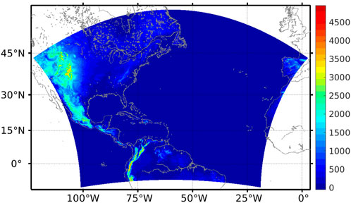
The land and ocean are two-way coupled with the Noah Land-Surface Model (Noah-LSM; Ek et al., 2003) and the HYbrid Coordinate Ocean Model (HYCOM; Bleck, 2002), respectively. The ice model (CICE4) and the wave model (WW3) are not included in the HAFS ensemble system. The model operates on a single domain with an Extended Schmidt Gnomonic (ESG, Purser et al., 2020) grid at 6 km horizontal resolution, as illustrated in Figure 1. The atmospheric model has 65 vertical levels with a top layer at 2 hPa.
The atmospheric model physics uncertainties are accounted in the HAFS ensemble system in three ways, i.e., the Stochastic Kinetic Energy Backscatter scheme (SKEB; Shutts, 2005; Berner et al., 2009); the Stochastic HUMidity perturbations in the boundary layer scheme (SHUM; Tompkins and Berner, 2008); and the Stochastically Perturbed Parameterization Tendencies (SPPT; Buizza et al., 1999).
SKEB was developed to model the upscale propagation of small-scale variability commonly lost through numerical diffusion. SKEB introduces random perturbations to the stream function with a prescribed power spectrum and amplitude dependent on the local dissipation rate to counteract excessive kinetic energy loss in regions with significant dissipation. The stochastic patterns for SKEB in the HAFS ensemble are correlated in the vertical by smoothing the patterns in the vertical by approximately 30 passes of a 1–2–1 filter. The random pattern for each level uses a length scale of 500 km and a time scale of 6 h. The SHUM scheme is based on the idea that the actual triggering of deep convection will happen from plumes below the scale of the model grid. There is a stochastic aspect to the sub-grid variability of temperature and moisture. The stochastic effect of this sub-grid variability within the parameterization of deep convection is estimated by directly perturbing the near-surface grid scale humidity field, multiplying that field by a random pattern with a mean of 1.0 and variance that decays exponentially with height. A single random pattern is used, with a length scale of 500 km and a time scale of 6 h. SPPT represents uncertainty within physical parameterizations. Random spatial patterns are multiplied by the spatial patterns of the physical tendencies of model variables. The random spatial patterns have a specified decay time and spatial decorrelation scale but no vertical variability, except that the amplitude is typically reduced near the surface and tapers to zero above 100 hPa for numerical stability (Palmer et al., 2009). The random pattern for each level uses a length scale of 500 km and a time scale of 6 h.
The initial and lateral boundary uncertainties in the HAFS EPS are generated from the NCEP GEFS. The initial condition and the lateral boundary condition of the 20-member (perturbed) and 1-control (unperturbed) are generated from the GEFS (20-member + 1-control) GRIdded Binary version 2 (GRIB2) dataset in 0.5-degree resolution. There is no re-centering process in the current version of the HAFS ensemble. Since the operational GEFS has 30 perturbed members, the HAFS ensemble members are a subset of the GEFS members, which may introduce a bias for the ensemble mean fields. The initial ocean condition for the HYCOM model comes from the analysis of the NOAA’s Global Real-Time Ocean Forecast System (Global RTOFS).
2.2 Code porting to AWS cloud
The AWS provided the High-Performance Computing (HPC) resources for the HAFS ensemble in the cloud via the Parallel Works middleware platform. A permanent Lustre file system containing 48 TB of disk space and 168 Amazon Reserved Instances (nodes) were obtained to perform real-time forecasts for the 21-member HAFS ensemble. A job-running environment, similar to NOAA’s on-premises machines, is created by installing the necessary modules/libraries and the HAFS ensemble workflow (Rocoto). All forecast data generated by the HAFS ensemble was stored in an AWS S3 bucket, facilitating accessibility for downstream users such as NHC and the National Ocean Service (NOS) for applications like wind, wave, and storm surge forecasts. Additionally, a subset of files was transferred to the NOAA Research and Development High-Performance Computing Systems (RDHPCS) machine to generate the graphics and display them in the NCEP Environmental Modeling Center (EMC) website (https://www.emc.ncep.noaa.gov/HAFS/HAFSEPS/index.php). Details about the primary HAFS ensemble products are presented in the following section.
3 HAFS ensemble products
The hurricane forecasters at the NHC and JTWC rely on a skillful and reliable high-resolution ensemble to issue forecasts for hurricane intensity, structure, and hazards (wind, wave, and storm surge) probabilities. The real-time HAFS ensemble was operated in the AWS cloud for the storms in the 2023 hurricane season, showcasing the advantages of high-resolution regional ensemble forecasts for hurricane track, intensity, Rapid Intensification (RI) probability, and hazard probability guidance.
3.1 Track and intensity forecast
Hurricane Idalia (AL10-2023) made landfall as a major hurricane (category 3) in Florida during the 2023 Atlantic hurricane season. Before its landfall at 12Z on 30 August 2023, Hurricane Idalia underwent a RI process, experiencing a 40-knot increase in its 10-meter maximum wind within 24 h, spanning from August 29 (06Z) to August 30 (06Z). The storm left a trail of significant damage across the Big Bend region of Florida and southeastern Georgia, resulting in the damage or destruction of thousands of structures and the unfortunate loss of four lives due to storm-related incidents in these two states. Early estimates pegged insured losses in the $2.2–5 billion range. During this event, the HAFS ensemble prediction system provided real-time probability guidance for Hurricane Idalia. This encompassed storm track predictions, intensity changes, wind, and precipitation. Such information proved invaluable for NHC forecasters, aiding in issuing hazard guidance (wind, wave, and storm surge) for the residents of Florida and other states along the East Coast.
Figure 2 displays Hurricane Idalia’s track ensemble forecast initialized at 00Z on 28 August 2023. The envelopes of the ensemble tracks cover the observed storm positions. Also, the landfall time and location of Idalia were predicted accurately by the HAFS ensemble 60 h before its landfall, which helped the emergency managers of the Federal Emergency Management Agency (FEMA) and the local government officers to plan ahead the evacuation of the residents in Florida.
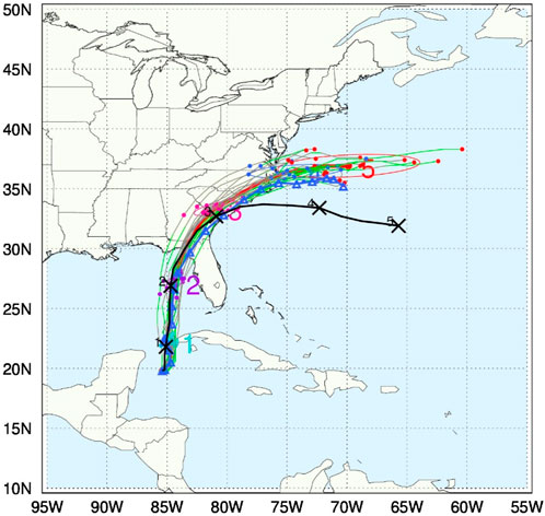
Figure 2. Hurricane track ensemble forecast for storm “Idalia” initialized at 00Z of 28 August 2023. The black: best track (observation); The red: ensemble-mean track; The green: the stronger members with their 10-meter maximum wind speed greater than the ensemble mean value; The gray: the weaker members with their 10-meter maximum wind speed smaller than the ensemble mean value.
The HAFS ensemble intensity forecast for the same cycle is demonstrated in Figure 3. The envelope of the ensemble intensity (10-meter maximum wind speed in (Figure 3A) and minimum sea level pressure (Figure 3B)) at each forecast hour covers the observation intensity of Idalia. Also, the intensity change rate agrees well with the observed intensity change. The probability of the RI of Idalia is about 70% (Figure 4), which is a good indicator for forecasters to issue the hazards (wind, wave, and storm surge) guidance before Idalia actually made landfall on the west coast of Florida.
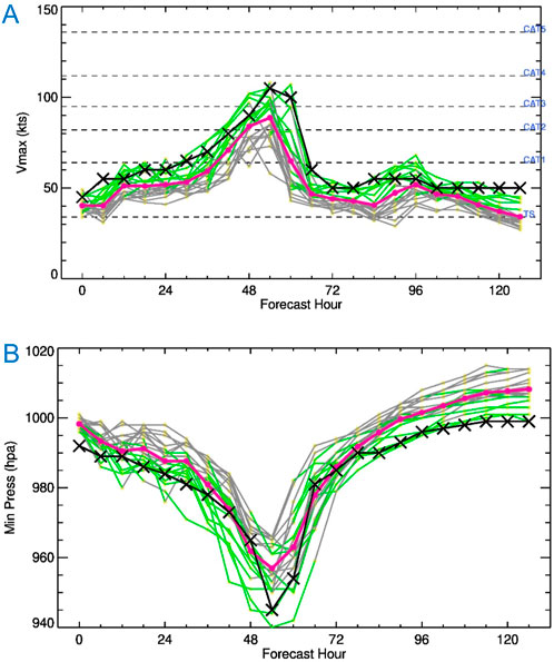
Figure 3. Hurricane intensity ensemble forecast for storm “Idalia” initialized at 00Z of 28 August 2023. (A) Maximum 10 m wind speed. (B) Minimum sea level pressure. The black: observation; The red: ensemble-mean value; The green: the stronger members; The gray: the weaker members.
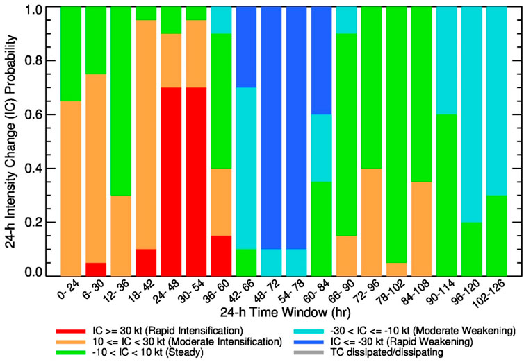
Figure 4. Hurricane intensity change probability forecast for storm “Idalia” initialized at 00Z of 28 August 2023. The red bar: maximum 10 m wind speed change exceed 30 kts in 24 h, which is the Rapid Intensification definition.
3.2 Wind speed probability forecast
The HAFS ensemble also provides the probability of the 10-meter winds greater than 34-knot, 50-knot, and 64-knot (Figure 5 for 34-knot). The orange to red region in Figure 5 indicates an 80% higher probability of the 34-knot surface winds. This product would help NHC forecasters to issue wind damage warnings on the ocean for ship voyages and the residents on land on the west coast of Florida. The five-dimensional wind fields and other variables from the HAFS ensemble forecast could be applied to drive the downstream wave and storm surge models, which will help NHC forecasters issue the wave and storm surge probability guidance.
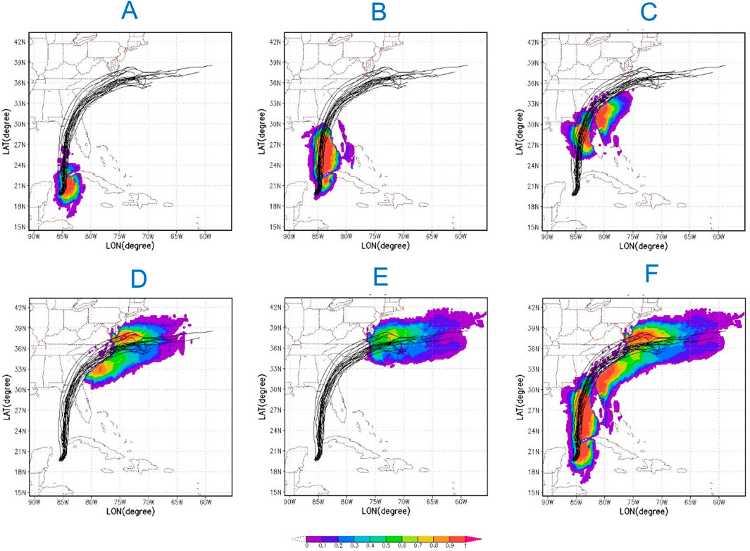
Figure 5. Hurricane surface wind probability forecast for storm “Idalia” initialized at 00Z of 28 August 2023. (A) Day 01; (B) Day 02; (C) Day 03; (D) Day 04; (E) Day 05 and (F) 5 days in total. The black lines: ensemble tracks. The shaded: the probability of the maximum 10-meter wind speed greater than 34 kts.
3.3 Precipitation probability forecast
The 5 days’ Probabilistic Quantitative Precipitation Forecasts (PQPF) with the surface precipitation exceeding 1, 4, and 8 inches are another important products from the HAFS ensemble forecasts (Figure 6 for 1 inch PQPF). The NWS Weather Prediction Center (WPC) and NHC would use these forecasts to issue the flooding warning before the landfall of Hurricane Idalia. The 24-hour (30–31 August, 2023, 00Z) observation precipitation from the NCEP Climatology-Calibrated Precipitation Analysis (CCPA) dataset (Figure 7) indicates that the Day-3 HAFS ensemble PQPF agrees well with the pattern of the observed heavy rainfall in the east coast, including Florida, Georgia, and South/North Carolina states.
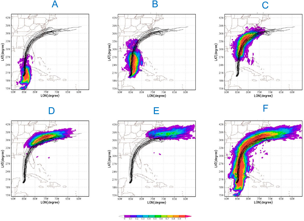
Figure 6. Hurricane precipitation probability forecast for storm “Idalia” initialized at 00Z of 28 August 2023. (A) Day 01; (B) Day 02; (C) Day 03; (D) Day 04; (E) Day 05 and (F) 5 days in total. The black lines: ensemble tracks. The shaded: the probability of the 24-hour precipitation greater than 1 inch.
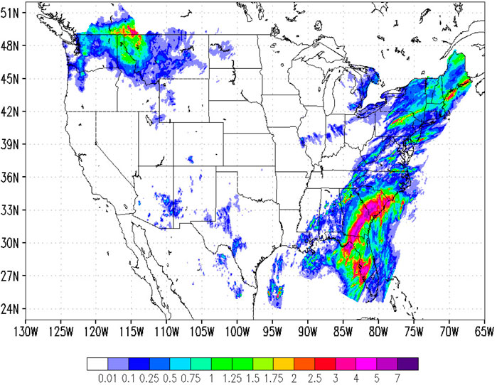
Figure 7. The 24 h (30–31 August, 2023, 00Z) precipitation (unit: inch) from NCEP Climatology-Calibrated Precipitation Analysis (CCPA).
4 Performance of the HAFS ensemble in 2023 hurricane season
The current NOAA GEFS-v12 was implemented on 23 September 2020. It has 30 perturbed and 1 control member with a 25 km horizontal resolution. ECMWF’s Integrated Forecasting System (IFS) upgrade to Cycle 48r1 was implemented on 27 June 2023. In the meantime, the horizontal resolution of 51-member ECMWF medium-range ensemble forecasts (ENS) has increased from 18 km to 9 km. The forecasters from NHC and JTWC usually apply the global ensembles’ track forecasts to generate the probability guidance of hurricane positions. They also demand a skillful high-resolution ensemble to predict TC intensity and structure change, which helps them to issue the hazards’ probability guidance for wind, wave, and storm surges. The HAFS ensemble was running in real-time in the AWS cloud to meet the needs of our forecasters.
4.1 Comparison to global ensembles
The performance evaluation of the HAFS ensemble forecasts during the 2023 hurricane season involved assessing both control-member and ensemble-mean forecasts, although the HAFS ensemble could provide critical uncertainty information for hurricane position, intensity, and structural changes. Even though the initial and lateral boundary conditions of HAFS ensemble were generated from GEFS forecast dataset, the comparative analysis between GEFS and HAFS ensemble aimed to demonstrate the advantages of the high-resolution regional ensemble for hurricane intensity forecasts.
Figure 8B illustrates that the ensemble mean intensity errors are notably smaller within 96 h compared to the corresponding GEFS mean intensity errors. The bias of HAFS ensemble intensity remains under 6 knots (see Figure 8C), while GEFS exhibits a larger bias, approximately 14 knots, in the 2023 Atlantic hurricane intensity forecasts. Notably, because the current HAFS ensemble does not include Vortex Initialization (VI) and Data Assimilations (DA), a negative bias is shown within the first 84 h. This limitation is anticipated to be addressed and reduced in the next version of the HAFS ensemble by invoking VI/DA processes.
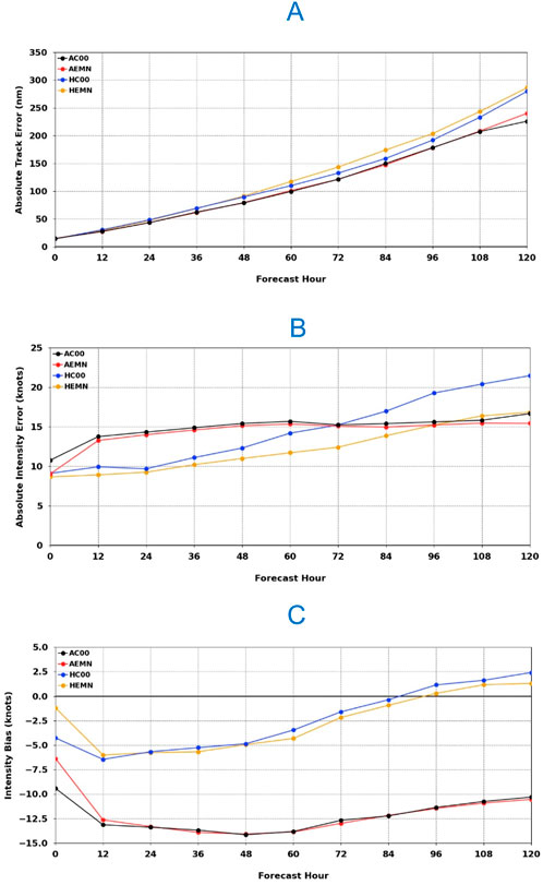
Figure 8. The 2023 Atlantic hurricane track error (A), intensity error (B) and intensity bias (C) for the GEFS/HAFS ensemble mean (AEMN/HEMN) and the GEFS/HAFS control-member (AC00/HC00) from the GEFS and HAFS ensemble forecasts.
On a different note, the HAFS ensemble track forecasts exhibit some degradation compared to GEFS forecasts (Figure 8A). The considerable track errors observed during the 2023 Atlantic hurricane season, particularly for the challenging track-forecast storm Philippe (AL17-2023), are attributed to its interaction with another storm, Rina (AL18-2023), known as the Fujiwhara Effect. Future updates for the HAFS model physic package are expected to improve this aspect.
As mentioned, the 51-member ECMWF ensemble was implemented with a 9 km horizontal resolution on 27 June 2023. The HAFS ensemble ran on a single regional domain with a 6 km horizontal resolution. This little difference in the resolution between HAFS and ECMWF ensembles significantly affects their hurricane intensity forecasts. The two ensemble forecast systems have many differences in their physics schemes, which may play a significant role in hurricane intensity forecasts. As shown in Figure 9A, the ECMWF ensemble has much bigger intensity errors than the HAFS ensemble in the first 84 forecast lead hours. The intensity bias is less than 6 kts for the HAFS ensemble, which is much smaller than the corresponding ECMWF ensemble with the 15 kts intensity bias (Figure 9B). The forthcoming integration of VI/DA utilities is expected to reduce the negative bias exhibited by the HAFS ensemble.
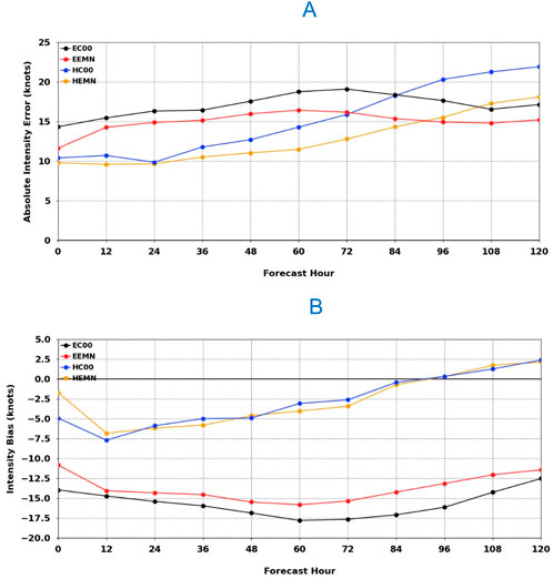
Figure 9. The 2023 Atlantic hurricane intensity error (A) and bias (B) for the ECMWF/HAFS ensemble mean (EEMN/HEMN) and the ECMWF/HAFS control-member (EC00/HC00) from the HAFS and ECMWF ensemble forecasts.
4.2 Comparison to HAFS-A model
The physics configuration of the HAFS ensemble is derived from the operational HAFS-A model, which features a parent domain at 6 km resolution and a moving nested domain at 2 km resolution. In contrast, the HAFS ensemble adopts a single uniform domain with a horizontal resolution of 6 km. Another method for evaluating the HAFS ensemble’s capability for intensity forecasts involves comparing its performance with the operational HAFS-A. Figure 10A reveals that the ensemble mean intensity errors of the HAFS ensemble closely align with the HAFS-A intensity errors, except for initial, more significant errors for the HAFS ensemble. This discrepancy in initial errors is attributed to the fact that the operational HAFS-A, benefiting from VI and DA in the nested domain, starts with a model vortex intensity close to the observed storm intensity. Conversely, the HAFS ensemble, lacking VI/DA functions, exhibits a negative intensity bias within the first 84 forecast hours (Figure 10B).
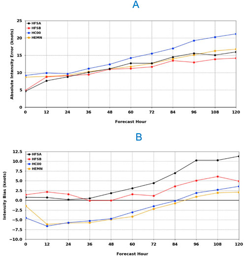
Figure 10. The 2023 Atlantic hurricane intensity error (A) and bias (B) for the HAFS ensemble mean (HEMN) and control-member (HC00), and the operational HAFS-A and HAFS-B forecasts.
4.3 The spread-skill relationship of HAFS ensemble
The primary objective of the HAFS ensemble is to depict the uncertainty inherent in hurricane forecasts, encompassing track, intensity, and structural changes. Typically, as forecast time progresses, the ensemble mean forecast error tends to increase, leading to a corresponding growth in uncertainty, represented by the ensemble spread. Ideally, a direct correspondence between ensemble spread and ensemble mean error should exist. Figure 11 illustrates the spread-skill relationship of GEFS and HAFS ensemble forecasts during the 2023 Atlantic hurricane season. As track errors expand over forecast hours, the spread amplifies with time as well. Both ensembles exhibit under-dispersive characteristics for hurricane track forecasts, with the GEFS ensemble displaying a better spread-skill relationship. On the other hand, the HAFS ensemble demonstrates smaller intensity errors compared to the GEFS ensemble. However, its intensity spread surpasses that of the GEFS ensemble, resulting in a more favorable spread-skill relationship for intensity forecasts with the HAFS ensemble. The HAFS ensemble’s track and intensity forecasts exhibit under-dispersive characteristics, which suggests the potential for improvement through advanced Stochastic Parameter Perturbation (SPP) in the model physics. Additionally, a comparison between the forecasts of the 21-member and 31-member HAFS ensembles for select hurricanes in the 2023 Atlantic season indicates that the 31-member ensemble provides a more robust Probability Density Function (PDF) and higher spread than the 21-member ensemble (Figure omitted for brevity).
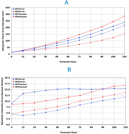
Figure 11. The 2023 Atlantic hurricane track error and spread (A), and intensity error and spread (B) from the HAFS (red) and GEFS (blue) ensemble forecasts.
5 Conclusion
The absence of a skillful and reliable high-resolution ensemble remains a substantial challenge for forecasters in the operational centers when issuing forecasts for TC track, intensity, structural changes, and associated hazards such as wind, wave, and storm surge probabilities. In response to the challenge, the HAFS-based EPS has been successfully transitioned to the AWS cloud. It operates in real-time, providing NHC forecasters with probabilistic hurricane forecasts throughout the 2023 hurricane season. Remarkably, the stability of the 168 Amazon Reserved Instances (nodes) allocated for the HAFS ensemble system ensured robust real-time forecasts during the 2023 Atlantic hurricane season.
The HAFS-EPS incorporates atmospheric model uncertainty through its stochastic physics suite, including Stochastically Perturbed Physics Tendencies (SPPT), Stochastically Kinetic Energy Backscatter (SKEB), and Stochastically Perturbed PBL Humidity (SHUM). Initial and lateral boundary conditions are derived from the NCEP operational GEFS 21-member forecasts. A comprehensive performance comparison of HAFS-EPS with global GEFS, global ECMWF ensemble, and operational deterministic HAFS forecasts for the 2023 Atlantic hurricane season reveals the advantages of higher resolution regional HAFS ensemble forecasts. Notably, the current version of the HAFS ensemble lacks VI and DA, leading to a significant bias in forecasting strong storms.
Both track and intensity spread of HAFS ensemble grow with forecast hours, but exhibit under-dispersive characteristics, indicating the need for more stochastic processes like SPP in the new version of the HAFS ensemble. In the meantime, the under-dispersive track forecasts can be addressed through perturbations in the initial position and intensity of vortices within the VI process.
Data availability statement
The datasets presented in this study can be found in online repositories. The names of the repository/repositories and accession number(s) can be found below: AWS S3 bucket.
Author contributions
JP: Formal Analysis, Investigation, Methodology, Writing–original draft, Writing–review and editing. ZZ: Formal Analysis, Investigation, Methodology, Project administration, Writing–review and editing. WW: Formal Analysis, Investigation, Methodology, Writing–review and editing. RP: Software, Writing–review and editing. BL: Investigation, Software, Writing–review and editing. YW: Investigation, Software, Writing–review and editing. AM: Project administration, Writing–review and editing. VT: Project administration, Writing–review and editing. XZ: Project administration, Writing–review and editing. SG: Project administration, Writing–review and editing. WK: Project administration, Writing–review and editing. JA: Project administration, Writing–review and editing. AP: Project administration, Writing–review and editing.
Funding
The author(s) declare that financial support was received for the research, authorship, and/or publication of this article. Fundings came from Hurricane Forecast Improvement Program (HFIP), the Disaster Relief Supplemental Act (DRSA) and the NOAA Office of the Chief Information Officer (OCIO).
Acknowledgments
The authors highly appreciate the internal review from Hananeh Jafary, Bo Yang, Eric Sinsky and Mary Hart at the NCEP/EMC.
Conflict of interest
Authors WK and JA were employed by I.M. Systems Group, Inc. at Office of Science and Technology Integration.
The remaining authors declare that the research was conducted in the absence of any commercial or financial relationships that could be construed as a potential conflict of interest.
The author(s) declared that they were an editorial board member of Frontiers, at the time of submission. This had no impact on the peer review process and the final decision.
Publisher’s note
All claims expressed in this article are solely those of the authors and do not necessarily represent those of their affiliated organizations, or those of the publisher, the editors and the reviewers. Any product that may be evaluated in this article, or claim that may be made by its manufacturer, is not guaranteed or endorsed by the publisher.
References
Berner, J., Shutts, G. J., Leutbecher, M., and Palmer, T. N. (2009). A spectral stochastic kinetic energy backscatter scheme and its impact on flow-dependent predictability in the ECMWF Ensemble Prediction System. J. Atmos. Sci. 66, 603–626. doi:10.1175/2008JAS2677.1
Bleck, R. (2002). An oceanic general circulation model framed in hybrid isopycnic-Cartesian coordinates. Ocean. Model. 4, 55–88. doi:10.1016/S1463-5003(01)00012-9
Brennan, M. (2023). “National hurricane center overview,” in 9th NOAA Ensemble Users Workshop, NCWCP, College Park, Maryland, MD, August 22-24, 2023. 20740.
Buizza, R., Miller, M., and Palmer, T. N. (1999). Stochastic representation of model uncertainties in the ECMWF ensemble prediction system. Quart. J. Roy. Meteor. Soc. 125, 2887–2908. doi:10.1256/smsqj.56005
Chen, J.-H., and Lin, S.-J. (2013). Seasonal predictions of tropical Cyclones using a 25-km-Resolution general circulation model. J. Clim. 26, 380–398. doi:10.1175/jcli-d-12-00061.1
Ek, M. B., Mitchell, K. E., Lin, Y., Rogers, E., Grunmann, P., Koren, V., et al. (2003). Implementation of Noah land surface model advances in the National Centers for Environmental Prediction operational mesoscale Eta model. J. Geophys. Res. Atmos. 108 (D22), 8851. doi:10.1029/2002JD003296
Harris, L. X., Chen, W., Putman, L., Zhou, L., and Chen, J.-H. (2021). A scientific description of the GFDL finite-volume cubed-sphere dynamical core. NOAA technical memorandum GFDL2021001. Available at: https://repository.library.noaa.gov/view/noaa/30725.
Hogsett, W. (2023). “Roles of ensembles in probabilistic IDSS and hazard risk communication at NHC,” in 9th NOAA Ensemble Users Workshop, NCWCP, College Park, Maryland, MD, August 22-24, 2023. 20740.
Houtekamer, P. L., Lefaivre, L., Derome, J., Ritchie, H., and Mitchell, H. L. (1996). A system simulation approach to ensemble prediction. Mon. Wea. Rev. 124, 1225–1242. doi:10.1175/1520-0493(1996)124<1225:assate>2.0.co;2
Iacono, M. J., Delamere, J. S., Mlawer, E. J., Shephard, M. W., Clough, S. A., and Collins, W. D. (2008). Radiative forcing by long-lived greenhouse gases: calculations with the AER radiative transfer models. J. Geophys. Res. Atmos. 113, D13103. doi:10.1029/2008JD009944
Komaromi, A. W., Reinecke, P. A., Doyle, J. D., and Moskaitis, J. R. (2021). The naval research laboratory’s Coupled Ocean–atmosphere mesoscale prediction system-tropical cyclone ensemble (COAMPS-TC ensemble). Wea. Forecast. 36, 499–517. doi:10.1175/WAF-D-20-0038.1
Krueger, S. K., Fu, Q., Liou, K. N., and Chin, H.-N. S. (1995). Improvements of an ice-phase microphysics parameterization for use in numerical simulations of tropical convection. J. Appl. Meteorology Climatol. 34, 281–287. doi:10.1175/1520-0450-34.1.281
Kucas, M. (2023). “Applications of ensembles for tropical cyclone forecasting at JTWC,” in 9th NOAA Ensemble Users Workshop, NCWCP, College Park, Maryland, MD, August 22-24, 2023. 20740.
Lin, S.-J. (1997). A finite-volume integration method for computing pressure gradient force in general vertical coordinates. Q. J. R. Meteorological Soc. 123, 1749–1762. doi:10.1002/qj.49712354214
Lin, S.-J. (2004). A “vertically Lagrangian” finite-volume dynamical core for global models. Mon. Weather Rev. 132, 2293–2307. doi:10.1175/1520-0493(2004)132<2293:avlfdc>2.0.co;2
Lin, S.-J., and Rood, R. B. (1996). Multidimensional flux-form semi-Lagrangian transport schemes. Mon. Weather Rev. 124, 2046–2070. doi:10.1175/1520-0493(1996)124<2046:mffslt>2.0.co;2
Lin, S.-J., and Rood, R. B. (1997). An explicit flux-form semi-Lagrangian shallow-water model on the sphere. Q. J. R. Meteorological Soc. 123, 2477–2498. doi:10.1002/qj.49712354416
Lin, Y.-L., Farley, R. D., and Orville, H. D. (1983). Bulk parameterization of the snow field in a cloud model. J. Appl. Meteorology Climatol. 22, 1065–1092. doi:10.1175/1520-0450(1983)022<1065:bpotsf>2.0.co;2
Lord, S. J., Willoughby, H. E., and Piotrowicz, J. M. (1984). Role of a parameterized ice-phase microphysics in an axisymmetric, nonhydrostatic tropical cyclone model. J. Atmos. Sci. 41, 2836–2848. doi:10.1175/1520-0469(1984)041<2836:roapip>2.0.co;2
Mlawer, E. J., Taubman, S. J., Brown, P. D., Iacono, M. J., and Clough, S. A. (1997). Radiative transfer for inhomogeneous atmospheres: RRTM, a validated correlated-k model for the longwave. J. Geophys. Res. 102, 16663–16682. doi:10.1029/97JD00237
Palmer, T. N., Buizza, R., Doblas-Reyes, F., Jung, T., Leutbecher, M., Shutts, G. J., et al. (2009). Stochastic parametrization and model uncertainty. Tech. Memo. 598. European Centre for Medium-Range Weather Forecasts. doi:10.21957/ps8gbwbdv
Purser, R. J., Jovic, D., Ketefian, G., Black, T., Beck, J., Dong, J., et al. (2020). The Extended Schmidt Gnomonic grid for regional applications. Available at: https://dtcenter.org/sites/default/files/events/2020/2-purser-james.pdf (Accessed July 27, 2020).
Shutts, G. (2005). A kinetic energy backscatter algorithm for use in ensemble prediction systems. Quart. J. Roy. Meteor. Soc. 131, 3079–3102. doi:10.1256/qj.04.106
Tompkins, A. M., and Berner, J. (2008). A stochastic convective approach to account for model uncertainty due to unresolved humidity variability. J. Geophys. Res. 113, D18101. doi:10.1029/2007JD009284
Torn, R. D. (2016). Evaluation of atmosphere and ocean initial condition uncertainty and stochastic exchange coefficients on ensemble tropical cyclone intensity forecasts. Mon. Wea. Rev. 144, 3487–3506. doi:10.1175/MWR-D-16-0108.1
Wang, W., Han, J., Shin, J., Chen, X., Hazelton, A., Zhu, L., et al. (2023). Physics schemes in the first version of NCEP operational hurricane analysis and forecast system (HAFS). Front. Earth Sci. 12. (in print). doi:10.3389/feart.2024.1379069
Zhang, Z., Tallapragada, V., Kieu, C., Trahan, S., and Wang, W. (2014). HWRF based ensemble prediction system using perturbations from GEFS and stochastic convective trigger function. Trop. Cyclone Res. Rev. 3, 145–161. doi:10.6057/2014TCRR03.02
Zhang, Z., Wang, W., Doyle, J. D., Moskaitis, J., Komaromi, W. A., Heming, J., et al. (2023). A review of recent advances (2018-2021) on tropical cyclone intensity change from operational perspectives, Part 1: dynamical model guidance. Trop. Cyclone Res. Rev. 12, 30–49. doi:10.1016/j.tcrr.2023.05.004
Zhang, Z., Wang, W., Liu, B., Zhu, L., Mehra, A., and Tallapragada, V. (2021). Performance of HAFS-based ensemble prediction system (HAFSv0.2E) in 2021 atlantic hurricane season. Available at: https://hfip.org/sites/default/files/events/269/1245-zhanzhang-hafsv02e.pdf.2021HFIPannualmeeting (Accessed November 15, 2021).
Zhou, X., Zhu, Y., Hou, D., Fu, B., Li, W., Guan, H., et al. (2022). The development of the NCEP global ensemble forecast system version 12. Wea. Forecast. 37, 1069–1084. doi:10.1175/WAF-D-21-0112.1
Keywords: Hafs, ensemble, AWS cloud, hurricane, forecast
Citation: Peng J, Zhang Z, Wang W, Panda R, Liu B, Weng Y, Mehra A, Tallapragada V, Zhang X, Gopalakrishnan S, Komaromi W, Anderson J and Poyer A (2024) HAFS ensemble forecast in AWS cloud. Front. Earth Sci. 12:1396612. doi: 10.3389/feart.2024.1396612
Received: 06 March 2024; Accepted: 13 September 2024;
Published: 10 October 2024.
Edited by:
Ping Zhu, Florida International University, United StatesReviewed by:
Srinivas Desamsetti, National Centre for Medium Range Weather Forecasting, IndiaFeifei Shen, Nanjing University of Information Science and Technology, China
Copyright © 2024 Peng, Zhang, Wang, Panda, Liu, Weng, Mehra, Tallapragada, Zhang, Gopalakrishnan, Komaromi, Anderson and Poyer. This is an open-access article distributed under the terms of the Creative Commons Attribution License (CC BY). The use, distribution or reproduction in other forums is permitted, provided the original author(s) and the copyright owner(s) are credited and that the original publication in this journal is cited, in accordance with accepted academic practice. No use, distribution or reproduction is permitted which does not comply with these terms.
*Correspondence: Jiayi Peng, amlheWkucGVuZ0Bub2FhLmdvdg==
 Jiayi Peng
 Zhan Zhang
 Weiguo Wang
 Rajendra Panda4
 Bin Liu
 Yonghui Weng
 Avichal Mehra
 Vijay Tallapragada
 Xuejin Zhang
 William Komaromi