
95% of researchers rate our articles as excellent or good
Learn more about the work of our research integrity team to safeguard the quality of each article we publish.
Find out more
ORIGINAL RESEARCH article
Front. Earth Sci. , 15 September 2022
Sec. Interdisciplinary Climate Studies
Volume 10 - 2022 | https://doi.org/10.3389/feart.2022.960420
 Vibeke Vandrup Martens1*
 Lars Krangnes2
The CULTCOAST research project has installed environmental monitoring equipment at two cultural heritage sites in northern Norway: one at the coal mine site of Hiorthhamn on Svalbard, one at the settlement mound site Sjåberget on Andøya in Nordland County. Both these coastal heritage sites are situated north of the Arctic circle, in the areas most impacted by climate change. Whereas the global temperature increase since 1970 is just above 1°C, in Svalbard the increase is now 4°C. This is the first example of using this specific type of sensors to monitor the ongoing changes and their possible impacts on preservation of heritage sites.
Global climate change presents a variety of threats towards the preservation of cultural heritage sites. Svalbard is where the strongest warming of all weather stations in Europe has been registered in the last few decades (Nordli et al., 2014). CULTCOAST—Cultural Heritage Sites in Coastal Areas. Monitor, Manage and Preserve Sites and Landscapes under Climate Change and Development Pressure is a research project funded by the environmental research programme of the Research Council of Norway (NFR MILJØFORSK), Project Number: 294,314. April 2019–March 2023.
The importance of cultural heritage is stressed in several international conventions (e.g., UNESCO 1972; Council of Europe 1992) and described as sources of collective memory as well as instruments for historical and scientific studies. However, there are and have been on-going discussions on site preservation (e.g., Willems 2008; Hollesen and Matthiesen, 2015; Martens, 2016). The CULTCOAST project aims to assess the possibilities for the long-term preservation of legally protected archaeological and built cultural heritage sites in the context of geo-hazards caused by changing climate conditions, and to suggest innovative tools for risk assessment, mapping, evaluating, prioritising, mitigation/adaptation, and sustainable management of heritage sites. We look at the individual and combined impacts of climate change induced geo-hazards and pressure from tourism and development. The CULTCOAST project focuses on 1) first, sustainable use and protection of coastal cultural heritage, cultural environments, and cultural landscapes; 2) secondly, on climate change induced geo-hazards; and 3) thirdly, how public management can safeguard cultural history values. Values are here meant as both tangible and intangible cultural heritage, including the physical remains both above and below ground (tangible) as well as the traditional use of the sites and landscapes (intangible). Cultural heritage and cultural environments are highly valued environmental goods, but these values are under serious threat from multiple sources, including inadequate safeguarding, climate change and pressure on land areas (Harmsen et al. 2018; Hollesen et al. 2018; Martens 2017; Sesana et al. 2021).
Climate is changing now at an even higher rate than expected in some of the worst-case climate scenarios (Climate Research Unit; IPCC 2021). These changes increase the risks of geo-hazards threatening heritage sites, environments and landscapes. The Arctic and sub-Arctic areas are particularly sensitive because they suffer more from combined threats and have previously been well protected by the aid of permafrost and sea ice, (Førland et al., 2011; Nordli et al., 2014; IPCC 2021). Svalbard is where the strongest warming of all weather stations in Europe has been registered in the last few decades (Nordli et al., 2014). The challenges of climate change are global, and the bequest value of cultural heritage, preserving it for future generations, is of relevance everywhere, thus our studies will be transferable to cultural heritage management plans and adaptation/mitigation actions at national and global scales, to meet the UN Sustainable Development Goals on resilient and sustainable settlements (goal #11) and taking urgent action to combat climate change and its impacts (goal #13). The CULTCOAST project focuses on the individual and combined impacts of climate change induced geo-hazards and pressure from tourism and development on coastal cultural heritage sites in northern Norway, using the Arctic and sub-Arctic sites as basis for future modelling that will have global use. We are currently monitoring sites on both Svalbard and Andøya in Norway—visually, with repeated point measurements, and with automatic repeated measurement installed in the ground. This paper will present continuous monitoring measurements from these sites and discuss the possible impacts on cultural heritage site preservation that may be derived from these measured data.
The heritage sites chosen for study within the CULTCOAST project (Figure 1) are two in the Arctic Archipelago Svalbard: the 18th–19th C hunting station Russekeila at the mouth of the Linné River at the southwestern edge of Isfjorden (The Ice Fiord) with both archaeological and built remains, and the 19th–20th C coal mine site of Hiorthhamn at the northeastern end of Isfjorden just across the bay from Longyearbyen consisting of a large amount of built heritage and remains from mining activities (see also Flyen et al., 2020; Nicu et al., 2020). The following two sites are on the island of Andøya, Nordland County: the settlement mound Høyvika and the settlement mound Sjåberget, both archaeological sites on the west coast of the island, consisting of preserved deposits from mainly the medieval and later periods (a. 1000AD-a. 19th C).
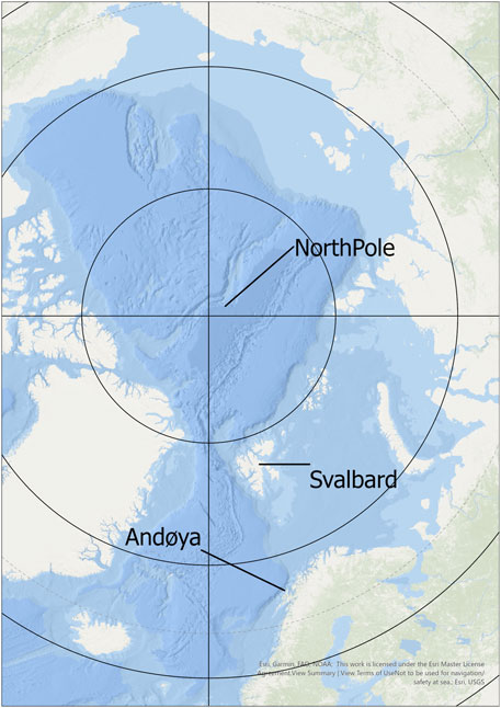
FIGURE 1. Map of the Arctic area, with Svalbard and Andøya marked. Map created by Jani Causevic, NIKU, 2022.
Environmental monitoring of archaeological deposits has been carried out in Norway for a several decades, the first project in the medieval town of Trondheim started in 1996 (Peacock 2002; Petersén & Bergersen 2012), followed by a site in the medieval town Tønsberg in 1999 (Reed & Martens 2008), and the largest Norwegian urban monitoring project started at the World Heritage Site Bryggen in Bergen in 2000 (Matthiesen 2004; Rytter & Schonhowd 2015). Some monitoring has been performed in Oslo (Martens et al., 2012) and at a few heritage sites outside urban settings (Martens & Bergersen 2015; Martens 2016). These latter started our work on how climate change might impact in situ site heritage protection in the Nordic countries the future, and a concern about already visible impacts on sites. Consequently, a paradigm shift seems necessary, away from trying to preserve most heritage sites in situ and instead rescuing the information potential by investigation/excavation and documentation.
The authors have both worked with environmental monitoring for more than a decade, but as the project started, a new probe type was launched that sparked our interest, the Campbell SoilVUE10, SoilVUE10: TDR Soil Moisture Profile Sensor (campbellsci.eu). This probe is only 5 cm in diameter and 1 m deep (measuring water content, temperature, permittivity and conductivity at nine different levels) and can thus be installed in a hand-augered hole at the site, thus making a minimum of physical impact on the listed sites that we wished to monitor. For both sites we applied for and were given permission by heritage management authorities before installation. The probes were attached to a data logger, Cautus logger CL1, and the data secured in a web solution, CautusWeb (Cautus Web), sending data over the mobile phone network four times a day at 6-h intervals. To run the datalogger, a battery pack was installed at both sites, and datalogger and battery pack were placed in a waterproof and—so far—polar bear proof stainless steel container to which an antenna was attached. In addition, solar panels were attached to the container and antenna at Andøya.
Hiorthhamn is a coal mine site with preserved infrastructure from the mining activities; a cableway station for shipping coal (the cableway reaching all the way up to the mine in the mountain above the settlement) (Figure 2), residential and working wooden buildings and barracks, wooden pathways, train rails, and steam engines, many of which are now strewn over the site, particularly on the beach (Figure 3). Some of the houses have been transformed into holiday cabins, others are in different states of disrepair and degradation. Cultural heritage sites in Svalbard consist mainly of traces of whaling, hunting, and coal mining (Flyen et al., 2020). The coastline is extremely active because of the combined impacts of climate change, with shorter periods of permafrost, a deeper active layer, and a diminished amount of sea ice/fiord ice protecting the sandy and gravelly deposits from wave actions (Nicu et al., 2020; Nicu et al., 2021). Thus, we intended to monitor the depth of the active layer to gather information on specific site preservation conditions. A point was chosen close to the beach erosion edge, and just out of the way of winter snow scooter tracks (Figure 4). The installation hole was augered by hand. The auger hit permafrost at 95 cm depth, making it almost physically impossible to hand-auger further down so a little more than 5 cm of the probe remained above ground. This was protected by laying a circle of stones around it, so that no-one would inadvertently disturb the connection between probe and logger cabinet. In addition, a reflective vest was tied to the antenna, to ensure visibility during winter, when the cabinet is expected to be covered in snow. This is important both to ensure the possibility of necessary battery maintenance but most of all to avoid snow scooter collisions with the antenna, as that might disrupt the data transfer (Figure 5). Practically, the system has been working very well with automatic data transfer via the mobile phone antenna. This enables real-time monitoring. It also gives information about when the batteries need to be recharged (at least two times a year), and we have had local help to perform this task. Because of the cold, the batteries need charging more often than they would in warmer climates. There is a lot of snow scooter traffic at the site in winter, and quite a bit of polar bear activity in the area, but thus far there have been no attempts to ‘investigate’ the logger cabinet, and the reflector is keeping the station safe from traffic.
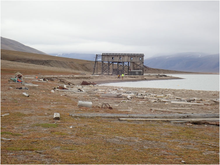
FIGURE 2. Hiorthhamn cableway station, Svalbard. Photo: Vibeke Vandrup Martens, NIKU 2019.
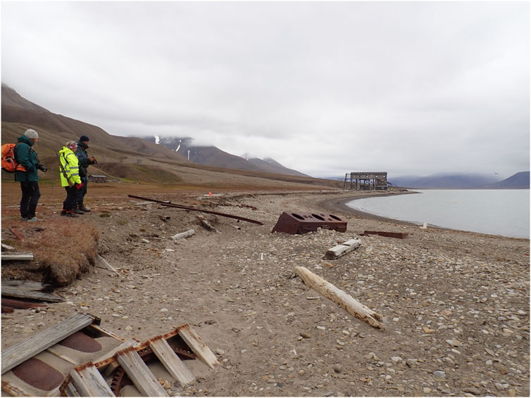
FIGURE 3. The beach at Hiorthhamn, Svalbard, with remains of steam engine and rails on beach. Photo: Vibeke Vandrup Martens, NIKU 2019.
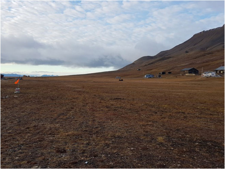
FIGURE 4. The beach at Hiorthhamn, Svalbard, with placing of monitoring station. Photo: Lena Rubensdotter, NGU & UNIS 2020.
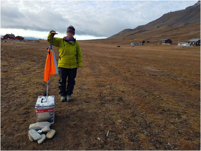
FIGURE 5. The monitoring station at Hiorthhamn, Svalbard. Photo: Andy Hodson, UNIS 2020.
Sjåberget settlement mound on Andøya is situated on the western coast of the island at a promontory between two beaches (Figure 6). A relatively modern building is still standing on the eastern edge of the mound, but otherwise it is now mainly grassland. Settlement mounds (also known as farm mounds) were created by repeated building activities at the same site, with houses built mainly of turf sods and timber. When they were no longer fit for habitation, they were torn down, the materials evened out, and new houses built on top (Bertelsen, 1984; Martens, 2016:31). There are a 900 settlement mounds listed as archaeological monuments in northern Norway (Martens 2016:16–23), of which more than half are in Nordland County. Thus, this was an important site type to monitor. A point was chosen at the south-western edge of the mound. At this site, like in Svalbard, the hole for installing the probe was augered by hand (auger blade diameter 4 cm). The top of the probe and the connection to the logger cabinet was secured by stones to avoid inadvertent disturbances. The concept has here been developed further, so in addition to the batteries in the stainless-steel box, a solar panel was attached to the antenna (Figure 7). This has allowed the batteries to be charged by solar power, and they got a charge sufficient to last through winter. So far it has therefore not been necessary to charge the batteries at the Andøya monitoring station. This is obviously very practical, ensuring unbroken data series and data transfer with no human resources necessary.
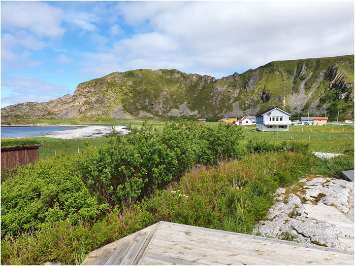
FIGURE 6. The setting of the settlement mound Sjåberget, Andøya, with the beach to the north. A similar beach is situated just south of the mound. Photo: Vibeke Vandrup Martens, NIKU 2021.
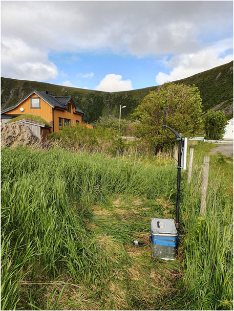
FIGURE 7. Environmental monitoring station installed at the settlement mound Sjåberget, Andøya. Note the solar panels on top of the logger cabinet. Photo: Vibeke Vandrup Martens, NIKU 2021.
Field work at Hiorthhamn was carried out in August 2019, making visual observations and evaluations of the state of preservation of single objects as well as the overall site, measuring the actual active coastline and measuring single points spread over the site to monitor possible solifluction impacts. This work was partly repeated the two following years. However, to ensure continuous information on preservation conditions, a monitoring probe was installed, and it is data from this probe that is presented here. The probe was installed 13 September 2020, and the plots (Figures 8–11) contain data until 11 March 2022. The sensors are placed at surface level/0, 5, 15, 25, 35, 45, 55, 70 and 95 cm depth.
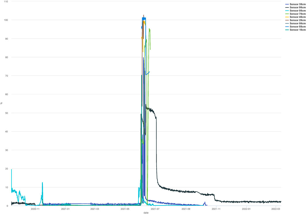
FIGURE 8. Hiorthhamn Svalbard monitoring point, soil water content plot, from installation 13 September 2020—11 March 2022. Plot by Lars Krangnes, Cautus Geo, from CautusWeb data.
Water content at Hiorthhamn is generally very low at all monitored levels. Mostly, the measured data indicates that no or very little water (less than 10%) is available in the deposits (Figure 8). That also coincides with low soil temperatures (Figure 9). However, in June 2021, the water levels increased dramatically in a very short space of time, to between 40 and 100% at all measuring depths. The soil temperatures rose to between +1 and +10°C in June and stayed that high until October, but the water content dropped long before that, thus indicating that the explanation for this dramatic change was snow melt, as the previous winter had been long and with good snow cover. The temperatures have been below 0 from October 2020 until June 2021, and again from October 2021 and until now. It will be interesting to follow the measurements in the coming change of season and in the coming years. Both permittivity and conductivity measurements (Figures 10, 11) are extremely low, except in the period around snow melt with the high soil water content.
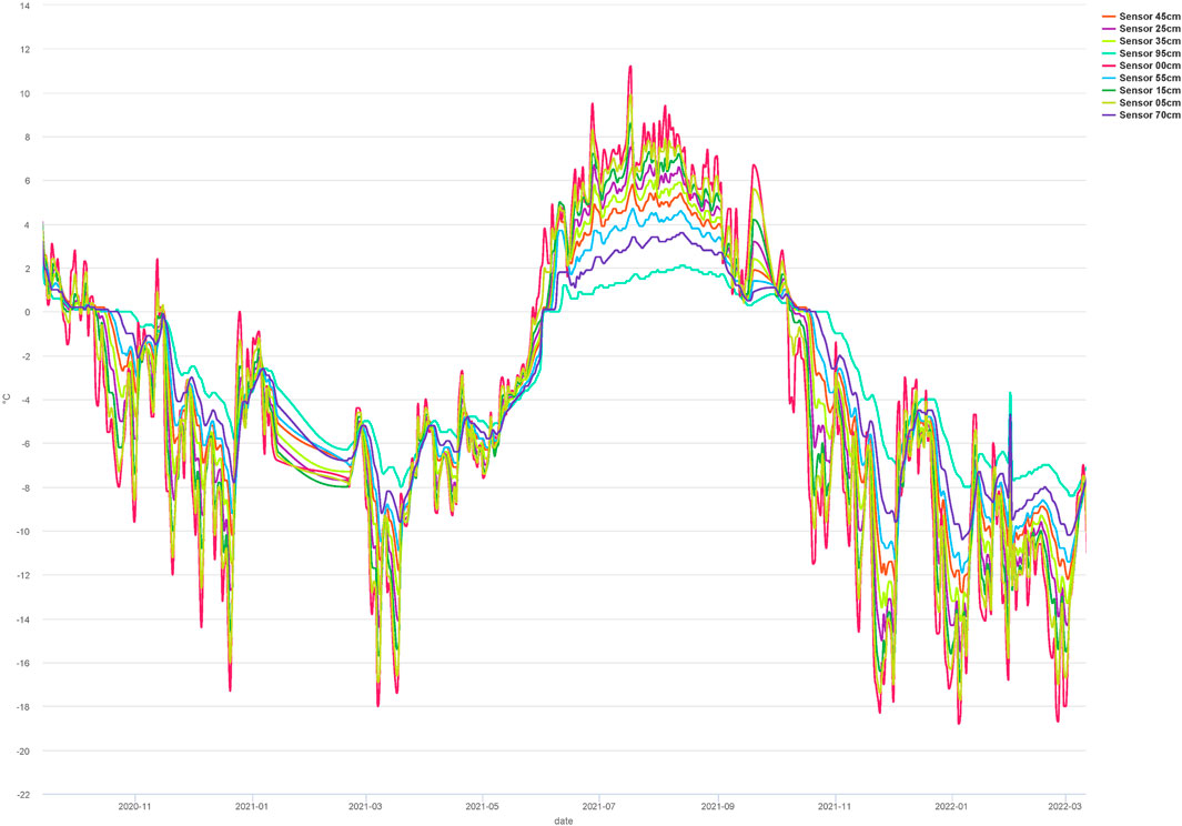
FIGURE 9. Hiorthhamn Svalbard monitoring point, soil temperature plot, from installation 13 September 2020—11 March 2022. Plot by Lars Krangnes, Cautus Geo, from CautusWeb data.
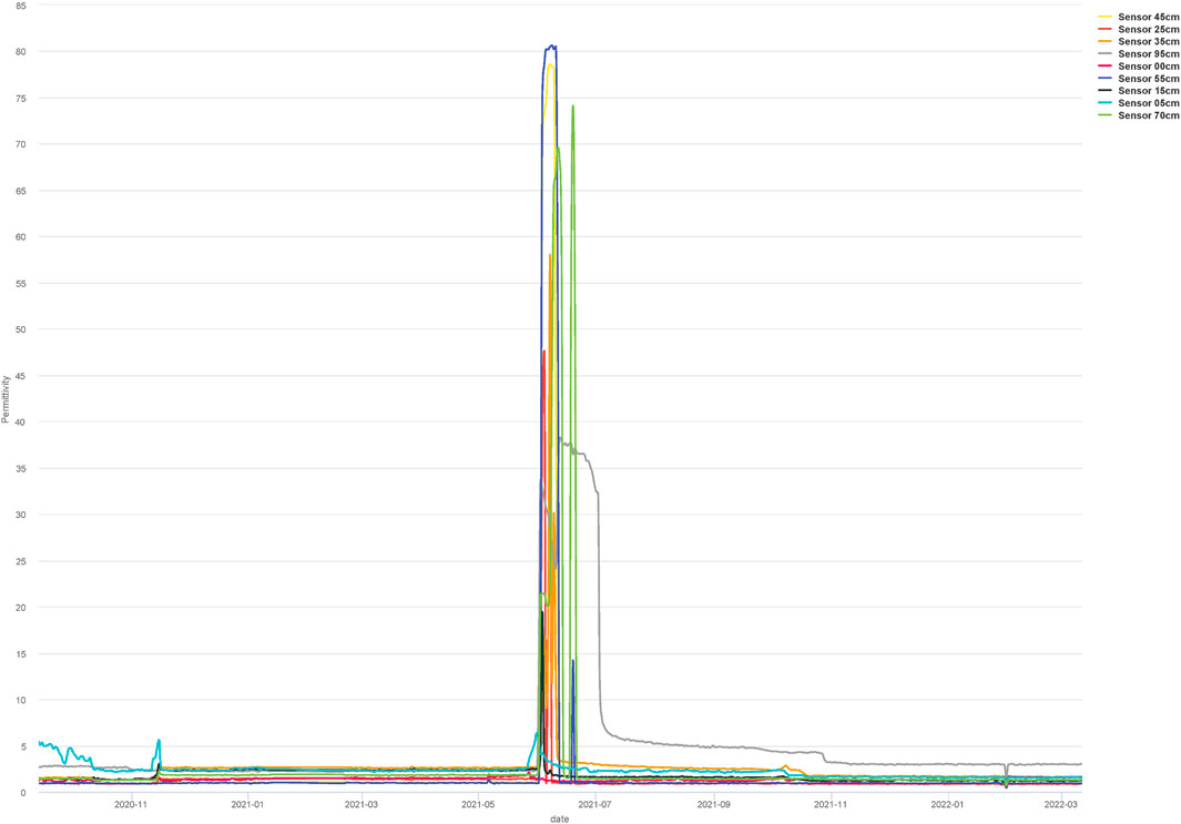
FIGURE 10. Hiorthhamn Svalbard monitoring point, permittivity plot, from installation 13 September 2020—11 March 2022. Plot by Lars Krangnes, Cautus Geo, from CautusWeb data.
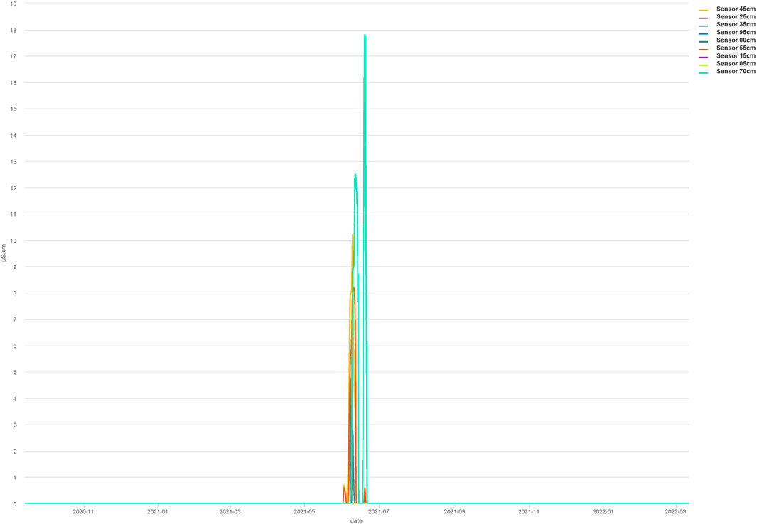
FIGURE 11. Hiorthhamn Svalbard monitoring point, electric conductivity plot, from installation 13 September 2020—11 March 2022. Plot by Lars Krangnes, Cautus Geo, from CautusWeb data.
For the heritage site, long periods of stability, both concerning temperatures and water content, are beneficial for continued preservation, and the longer the ground stays frozen, the less damage may be expected on the coastline, though other forces are clearly in play there as well (Nicu et al., 2021). It is a bit worrying that the soil temperatures seem to correspond very closely with measured air temperatures, but that is mostly a demonstration of the character of the deposits, which are sandy and gravelly. At this particular site, the monitored deposits are all subsoil i.e., geological, not sub-surface archaeological deposits, and thus the worry here is not degrading archaeological deposits but the depth of the active layer and the length of time that the fragile coastal layers are thawed, which increases the risks of coastal erosion and subsequently risks of loss of heritage remains. In this particular case the remains consist mainly of built heritage. Longer warm periods also increase risks of fungal decay to the wooden constructions (Flyen et al. 2020).
Field work on Andøya was carried out summer 2021 (postponed 1 year because of the pandemic, and with reduced staff for the same reasons), making visual observations and evaluations of the state of preservation of the overall site, measuring the coastline and mapping other possible sources of geo-hazards such as e.g., coastal erosion, sea level rise, landslides or solifluction. Again, to ensure continuous information on preservation conditions, a monitoring probe was installed, and it is data from this probe that is presented here. The probe was installed 8 June 2021, and the plots (Figures 12–15) contain data until 11 March 2022. The archaeological deposits here consisted of organic-rich sandy humus, covered by grass turf, so the augering could be carried out fairly easily. The sensors are placed at 5, 10, 20, 30, 40, 50, 60, 75 and 100 cm depth below surface.
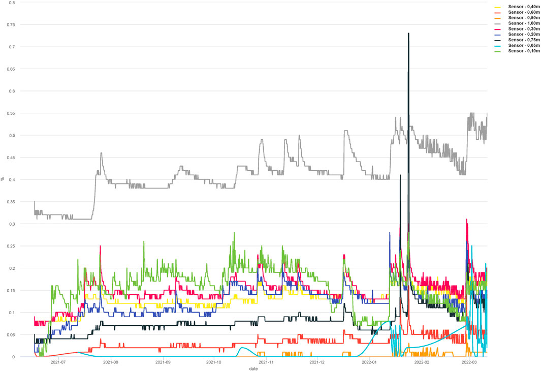
FIGURE 12. Sjåberget Andøya monitoring point, soil water content plot, from installation 8 June 2021—11 March 2022. Plot by Lars Krangnes, Cautus Geo, from CautusWeb data.
The soil water content in the archaeological deposits of Sjåberget settlement mound vary considerably more than at Hiorthhamn (Figure 12). The deepest sensor at 1 m depth has a stable water content between 30 and 50%, whereas all the others are stable between 0 and 25%, except for the two top sensors which have a rapid increase in water content in late January 2022. This drops again very shortly after, and it coincided with a major rainstorm. This would indicate that the organic-rich and compact archaeological deposits of the settlement mound are generally stable, and only the top sensors and deposits are affected directly by precipitation events.
The soil temperature (Figure 13) was high at the time of installation (a nice summer day) but dropped and stabilised for all sensors. During the autumn, the soil temperatures measured stayed below 10°C in most of the deposits, and as winter came, the temperatures dropped to a 1°C and stayed stable throughout the measured period. It will be interesting to see the measurements during the coming summer. We know that temperatures below 10°C are favourable preservation conditions for all organic matter, reducing biological and chemical degradation to a minimum (Hollesen & Matthiesen 2015; Møller et al., 2015), so the longer they stay below, the less active the degradation processes will be, and the better are the options of continued site preservation. Permittivity measurements (Figure 14) more or less follow the pattern of water content, whereas conductivity (Figure 15) to a higher degree matches the temperature measurements.
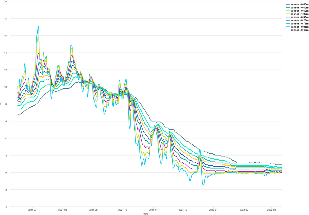
FIGURE 13. Sjåberget Andøya monitoring point, soil temperature plot, from installation 8 June 2021—11 March 2022. Plot by Lars Krangnes, Cautus Geo, from CautusWeb data.
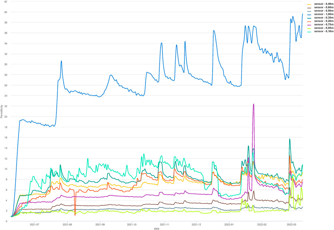
FIGURE 14. Sjåberget Andøya monitoring point, permittivity plot, from installation 8 June 2021—11 March 2022. Plot by Lars Krangnes, Cautus Geo, from CautusWeb data.
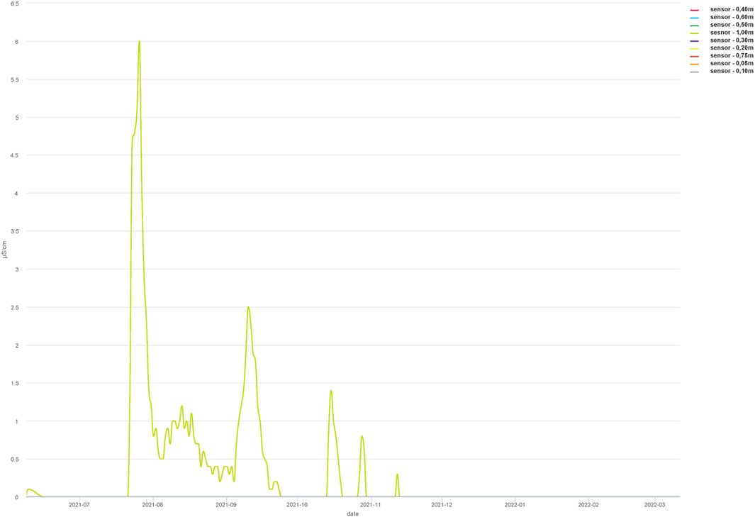
FIGURE 15. Sjåberget Andøya monitoring point, electric conductivity plot, from installation 8 June 2021—11 March 2022. Plot by Lars Krangnes, Cautus Geo, from CautusWeb data.
In general, the preservation conditions at Sjåberget seem stable and apparently only the top deposits are more directly influenced by precipitation and, probably, air temperature changes. However, we still have less than a year of measured data, so it is a premature to draw it is premature to draw firm conclusions. It has worked well to implement solar panels as an additional power source, effectively charging the batteries enough to last through the dark period of the year. It might have worked in Svalbard as well, though the dark period is longer that far north, but it might have saved at least one battery change a year. This is something we will consider for future monitoring stations that do not have continuous electric power supply readily available.
The material presented here is from an on-going research project, so by no means yet fully explored. We realise that the data sets are limited to only two sites, one in Arctic and one in sub-Arctic settings, and at very differing heritage sites. One site is built heritage on sub-soil threatened by coastal erosion due to thawing permafrost, fungal decay of wooden constructions, and human site use; the other is archaeological heritage with well-preserved deposits, threatened mainly by sea level rise and human actions. We are also aware that the monitored periods are still short, and the data thus limited. However, we do see what we interpret as clear trends that will be interesting to follow further. The Svalbard site is mainly impacted by large water influx during snow melt but otherwise without major events. However, the active layer may penetrate further into the permafrost, which would be highly undesirable. The Andøya site shows more direct fluctuations in measurements related to precipitation and air temperatures, particularly in the sensors closest to the surface, but overall demonstrates stable preservation conditions so far. We firmly believe that this type of probe with its minor physical impact on the listed heritage may be beneficial to use also in other settings, as it seems to provide sufficient information to evaluate the site preservation conditions. It is thus comparable to augering a borehole for a dipwell in saturated deposits, something which heritage management authorities often allow, while being more restrictive to opening sections to install soil probes monitoring (soil monitoring probes). Using the type of monitoring probe presented here might thus allow monitoring at sites where opening a section would be neither possible nor desirable, but where it is still deemed relevant and necessary to obtain information on preservation conditions, to enable evaluation of whether to continue in situ site preservation or whether the site is in danger of disappearing through accelerated degradation to such an extent that one should either implement adaptive measures or rescue the heritage information by investigation and documentation.
The raw data supporting the conclusion of this article will be made available by the authors, without undue reservation.
The authors have contributed differently; idea (VVM); writing (VVM, LK); figures (LK, VVM); data analyses (VVM, LK).
The CULTCOAST project is financed by the Research Council of Norway, grant number 294314, environmental research. In addition, Cautus Geo AS has co-financed the monitoring systems.
Our thanks to all members of the CULTCOAST project for fieldwork commitment and to Cautus Geo employees for preparation of the monitoring systems. Special thanks to Andy Hodson, UNIS (the University Centre in Svalbard), for installation aid and many battery changes at Hiorthhamn.
LK is owner and co-founder of Cautus Geo AS.
The remaining authors declare that the research was conducted in the absence of any commercial or financial relationships that could be construed as a potential conflict of interest.
All claims expressed in this article are solely those of the authors and do not necessarily represent those of their affiliated organizations, or those of the publisher, the editors and the reviewers. Any product that may be evaluated in this article, or claim that may be made by its manufacturer, is not guaranteed or endorsed by the publisher.
Bertelsen, R. (1984). Farm mounds of the harstad area. Quantitative investigations of accumulation characteristicsActa Boreal., 1, 7–25 doi:10.1080/08003838408580303
Council of Europe (1992). European convention on the protection of the archaeological heritage. Available at: http://conventions.coe.int/Treaty/en/Treaties/Html/143.htm.
crudata Climate research unit. Available at: https://crudata.uea.ac.uk/cru/.
Flyen, A. C., Flyen, C., and Mattsson, J. (2020). Climate change impacts and fungal decay in vulnerable historic buildings at Svalbard. E3S Web Conf. 172, 20006. doi:10.1051/e3sconf/202017220006
Førland, E. J., Benestad, R., Hanssen-Bauer, I., Haugen, J. E., and Skaugen, T. E. (2011). Temperature and precipitation development at Svalbard 1900-2100. Adv. Meteorology 2011, 1. doi:10.1155/2011/893790
Harmsen, H., Hollesen, J., Madsen, C. K., Albrechtsen, M., Myrup, M., and Matthiesen, H. (2018). A ticking clock? preservation and management of Greenland’s archaeological heritage in the twenty-first century. Conservation and Management of Archaeological Sites 20 (4), 175–198. doi:10.1080/13505033.2018.1513303
Hollesen, J., and Matthiesen, H. (2015). The influence of soil moisture, temperature and oxygen on the oxic decay of organic archaeological deposits. Archaeometry 57, 362–377. doi:10.1111/arcm.12094
Hollesen, J., Callanan, J. M, Dawson, T., Fenger-Nielsen, R., Friesen, T. M., and Jensen, A. M. (2018). Climate change and the deteriorating archaeological and environmental archives of the Arctic. Antiquity 92 (363), 573–586. doi:10.15184/aqy.2018.8
IPCC 2021 Intergovernmental panel on climate change, Available at: http://www.ipcc.ch/report/ar6/.
Martens, V. V., Amundsen, C-E., and Bergersen, O. (2012). Research on conservation state and preservation conditions in unsaturated archaeological deposits in Oslo. Conservation Manag. Archaeol. Sites 14, 72–84. doi:10.1179/1350503312z.0000000007
Martens, V. V., and Bergersen, O. (2015). In situ site preservation in the unsaturated zone: Avaldsnes. Quat. Int. 368, 68–79. doi:10.1016/j.quaint.2014.10.031
Martens, V. V. (2016). Preserving rural settlement sites in Norway? Investigations of archaeological deposits in a changing climate. Geoarchaeological Bioarchaeological Stud. 16.doi:10.13140/RG.2.2.26211.63528
Martens, V. V. (2017). Mitigating Climate Change Effects on Cultural Heritage Sites?. Archaeological Review from Cambridge 32 (2), 123–140
Matthiesen, H. (2004). “In situ preservation and monitoring of the cultural layers below Bryggen,” in Safeguarding historic waterfront sites. Bryggen in Bergen as a case study. Editor A. Christensson (Szcecin/- Bergen: Stiftelsen Bryggen), 71–75.
Møller, A. B., Matthiesen, H., and Hollesen, J. (2015). The effect of temperature and soil moisture on the decomposition of organic material in archaeological deposits at two contrasting sites in northern Norway. Copenhagen: National Museum of Denmark, 11031962.
Nicu, I. C., Rubensdotter, L., Stalsberg, K., and Nau, E. (2021). Coastal erosion of arctic cultural heritage in danger: A case study from svalbard, Norway. Water 13, 784. doi:10.3390/w13060784
Nicu, I. C., Stalsberg, K., Rubensdotter, L., Martens, V. V., and Flyen, A.-C. (2020). Coastal erosion affecting cultural heritage in svalbard. A case study in Hiorthhamn (Adventfjorden)—an abandoned mining settlement. Sustainability 12, 2306. doi:10.3390/su12062306
Nordli, Ø., Przybylak, R., Ogilvie, A. E. J., and Isaksen, K. (2014). Long-term temperature trends and variability on spitsbergen: The extended svalbard airport temperature series, 1898–2012. Polar Res. 33, 21349. doi:10.3402/polar.v33.21349
Peacock, E. E. (2002). Monitoring the in situ archaeological deposits at schultzgt. 3-7, Trondheim, Norway (1996-2001). NTNU, Vitenskapsmuseet. Rapp. Arkeol. Ser. 2002-1, 121.
Petersén, A., and Bergersen, O. (2012). An assessment of the status and condition of Archaeological remains preserved in situ in the medieval town of Trondheim based on archeochemical investigations conducted during the period 2007–2010. Conservation Manag. Archaeol. Sites 14, 228–238. doi:10.1179/1350503312z.00000000019
Reed, I., and Martens, V. V. (2008). Preservation capacity of urban archaeological deposits beneath modern buildings in NorwayGeo Bioarchaeological Stud. 10. Amsterdam, 265–272
Rytter, J., and Schonhowd, I. (Editors) (2015). Monitoring, mitigation, management. The groundwater project – safeguarding the World heritage site of bryggen in bergen (Oslo.
Sesana, E., Gagnon, A. S., Ciantelli, C., Cassar, J., and Hughes, J. J. (2021). Climate change impacts on cultural heritage: A literature review. Wiley interdisciplinary reviews: Climate Change 12 (1). doi:10.1002/wcc.710
UNESCO (1972). Available at: https://whc.unesco.org/en/convention/.
Keywords: Svalbard, Andøya, cultural heritage, environmental monitoring, climate change, Arctic
Citation: Martens VV and Krangnes L (2022) Monitoring as a tool to evaluate preservation possibilities. Results from the CULTCOAST project. Front. Earth Sci. 10:960420. doi: 10.3389/feart.2022.960420
Received: 02 June 2022; Accepted: 12 August 2022;
Published: 15 September 2022.
Edited by:
Deodato Tapete, Italian Space Agency (ASI), ItalyReviewed by:
Bryan Lintott, UiT The Arctic University of Norway, NorwayCopyright © 2022 Martens and Krangnes. This is an open-access article distributed under the terms of the Creative Commons Attribution License (CC BY). The use, distribution or reproduction in other forums is permitted, provided the original author(s) and the copyright owner(s) are credited and that the original publication in this journal is cited, in accordance with accepted academic practice. No use, distribution or reproduction is permitted which does not comply with these terms.
*Correspondence: Vibeke Vandrup Martens, dnZtQG5pa3Uubm8=
Disclaimer: All claims expressed in this article are solely those of the authors and do not necessarily represent those of their affiliated organizations, or those of the publisher, the editors and the reviewers. Any product that may be evaluated in this article or claim that may be made by its manufacturer is not guaranteed or endorsed by the publisher.
Research integrity at Frontiers
Learn more about the work of our research integrity team to safeguard the quality of each article we publish.