 Hua Ge
- 1Changjiang River Scientific Research Institute, Wuhan, China
- 2MWR Key Lab of River and Lake Regulation and Flood Control in the Middle and Lower Reaches of the Yangtze River, Wuhan, China
- 3Bureau of Hydrology, Changjiang Water Resources Commission, Wuhan, China
- 4Changjiang Waterway Bureau, Wuhan, China
In recent years, the operation of cascade reservoirs in the upper reaches of the Yangtze River led by the Three Gorges Reservoir has significantly changed the low water level of Dongting Lake, which has had an adverse impact on the water resources and ecological security in the lake area. As a result, the low water level situation of Dongting Lake is drawing more and more attention. Based on the abundant and long-term daily observation data of Dongting Lake and main stream of the Yangtze River, the spatial and temporal evolution characteristics of low water level in the Dongting Lake area since the 1950s were analyzed in this study, especially during the storage period of the Three Gorges Reservoir. In addition, the influence of the jacking effect of the Yangtze River on Dongting Lake was also discussed to analyze the impact of the Three Gorges Reservoir. The results show that the annual minimum water level in the Dongting Lake area over the years generally occurs from January to February and December. Since it is not within the storage period of the Three Gorges Reservoir, it is not affected by the Three Gorges Reservoir. However, the average water level in September and October during the main storage period of the Three Gorges Reservoir has significantly reduced, and the closer it is to the main stream of the Yangtze River, the greater the influence is. In recent years, affected by the advance of the impounding period, the average water level has decreased further in September. In addition, the low water level of Dongting Lake is obviously affected by the jacking effect of the main stream of the Yangtze River. After the impoundment of the Three Gorges Reservoir, the water surface slope of the Dongting Lake area has decreased, while that of the main stream of the Yangtze River has increased. This has strengthened the jacking effect of the main stream. The research results can provide reference for the solution of water resource and ecological crises in the Dongting Lake area.
Introduction
Dongting Lake receives the water through the three inlets, named Songzikou, Taipingkou, and Ouchikou, in Jingjiang reach from middle Yangtze River and the four rivers named Xiang River, Zi River, Yuan River, and Li River. After regulation and storage, it converges with the Yangtze River in Chenglingji, forming a trend of throughput of the Yangtze River with a characteristic relationship between the rivers and lake. In the past century, a series of human activities such as the construction of river and lake regulation projects have brought about a drastic adjustment in river and lake relations. The interaction between the increasingly fierce flood and drought disasters in river and lake systems has attracted great attention and controversy. In particular, the Three Gorges Reservoir (TGR) and other control water conservancy projects upstream of the Yangtze River have been completed and operated one after another, which strongly drives a new round of adjustment to relations between the river and the lake. Its impact on the low water level of Dongting Lake is drawing more and more attention from the academic community. Macro analysis of the variation of low water level in Dongting Lake and objective evaluation of the impact of the operation of TGR have become the focus of common concern of the government, society, and academia.
In recent years, some scholars have analyzed the change in low water level in Dongting Lake based on some measurements. For example, by taking Chenglingji, Yangliutan, and Nanzui as representative stations, Wang et al. (2021) believe that TGR has little impact on the water level change rate and extreme water level of Dongting Lake, while Lai et al. (2021) believe that the decline of the lake bed surface caused by the reduction of sediment in Dongting Lake after the impoundment of the TGR has led to the decline of water level in the lake area, represented by Chenglingji’s water level. Dai et al. (2020) and Han et al. (2016) think that reservoir storage is an important factor in reducing the water level of Dongting Lake. By using the hydraulic method, Zhou et al. (2014) considered that during the impounding stage of the TGR, the water level of the East Dongting Lake has dropped rapidly and the lake area entered the dry season one month in advance. During the dry season, the water level in Dongting Lake was raised due to the continuous replenishment of water from the discharge of the TGR. It shows that the water level in January and the lowest water level in 1, 3, 7, and 30 days at the mouth of Dongting Lake have changed significantly, and the degree of hydrological change was greater than 85%, which was mainly affected by the increase in rainfall and dam regulation (Cheng et al., 2019). Similar conclusions also appear in the research studies of Liang et al. (2018), Dai et al. (2018), and Cheng et al. (2018). The water storage of TGR exposed the wetland earlier and prolonged the autumn drought by about 30%. However, the simulation also shows that the normal operation of TGR does not change the natural drought trend of Dongting Lake, and it is not considered to be the main cause of recent hydrological droughts (Huang et al., 2014). In addition to the water storage and operation of TGR, some researchers believe that the precipitation in the Dongting Lake Basin, the runoff into and out of the lake, and the water regime of the main stream of the Yangtze River are the main influencing factors of the water level change of Dongting Lake (Meng et al., 2014; Zhou et al., 2017), and the influence degree of the Yangtze River water regime in different regions of the Dongting Lake is also different (Cheng et al., 2017). This is also confirmed by sensitivity analysis by the means of mathematical model (Jiang et al., 2019). In fact, the dry season of Dongting Lake is long, and the variation characteristics of low water level in different periods are different. The low water level in some periods has increased in recent years (Yuan et al., 2015; Zhang et al., 2015), and the water level changes in the lake area caused by different water regime changes in the main stream of the Yangtze River are also different (Liu et al., 2015). Among them, the study of typical hydrological years shows that the hydrological effect of TGR water storage on Dongting Lake is higher in the north and east of Dongting Lake, while it is less in the south and west of Dongting Lake, and the most significant effect is observed in the east of Dongting Lake (Lai et al., 2014). The change in river regime caused by TGR is not only due to the acceleration of lake drainage but also due to the reduction of the inflow of the Yangtze River. In extreme hydrological years such as 2006 and 2009, during TGR impoundment, the water level at the lake mouth was decreased by 2.03 and 2.11 m, respectively, and the extreme decline was as high as 3.30 and 3.02 m, respectively. These changes inevitably lead to the differences in inundation mode of the lake’s wetland, which then interfere with the ecological function of the lake wetland as the habitat of migratory birds and aquatic fish, resulting in a series of ecological problems. The severe drought of Dongting Lake in recent years is largely related to the abovementioned changes (Huang et al., 2011; Sun et al., 2012). Due to the low water level drop, the wetland vegetation pattern had significantly changed after the operation of TGD, mainly as a result of changes in submergence condition (Hu et al., 2018). The decline in water level has caused the lack of water supply in the Dongting Lake area (Fang et al., 2022). In addition, some studies believe that the TGD has provided some benefits for migratory birds by changing the spatial and temporal distribution of low water level (Zhu et al., 2021). Unfortunately, not only has the low water level of Dongting Lake further declined but Poyang Lake, China’s largest freshwater lake, is also suffering a declining trend in the dry water level after the impoundment of the Three Gorges Reservoir (Bing et al., 2020; Wang et al., 2020; Huang et al., 2021), and this has brought about water quality problems (Yang et al., 2018).
Based on the current research, there is no doubt that the impoundment of TGR has an impact on the low-water regime of Dongting Lake. Although there have been some studies on the impact of the storage period of TGR on the water level of Dongting Lake, the changes in TGR operation rules in recent years inevitably have a new impact. On the one hand, the storage time of TGR is advanced, and on the other hand, the medium and small floods are regulated in the flood season. At present, Dongting Lake is far from a lake with complete open water surface. It is divided into many lake groups connected by waterways, such as East Dongting Lake, South Dongting Lake, and West Dongting Lake, distributed in a narrow band from east to west. This feature is particularly obvious in dry season, and the variation characteristics of low water level in different regions are different. The current research results have been slightly insufficient to deal with the low water level situation in the Dongting Lake area. Therefore, based on the latest measured data from the 1950s to 2021, the characteristics of low water level in different areas of Dongting Lake were analyzed in this study, so as to further clarify the latest change trend and the impact of TGR. The research results can provide some support for solving the problems of water resources and ecology in the dry season in Dongting Lake area.
Study Area and Data
Dongting Lake is located at the south bank of Jingjiang reach in the middle Yangtze River, including the vast plain and lake water network area between 27°39´–29°51′N and 111°19´–113°34′E. It can be roughly divided into three parts: East Dongting Lake, South Dongting Lake, and West Dongting Lake, as shown in Figure 1. The Lujiao station is distributed in East Dongting Lake. South Dongting Lake is composed of Hengling Lake, Wanzi Lake, and Southeast Lake. The water level of Hengling Lake is represented by Yingtian station, and Wanzi Lake water level is represented by the Yangliutan station and Yuanjiang station. The water level of Southeast Lake is represented by Dongnan Hu station. West Dongting Lake is composed of Dalian Lake and Muping Lake, and its water level is represented by Xiaohezui station and Nanzui station, respectively. Chenglingji station is located at the outlet of Dongting Lake and can be also used as a water level reference station of the Yangtze River.
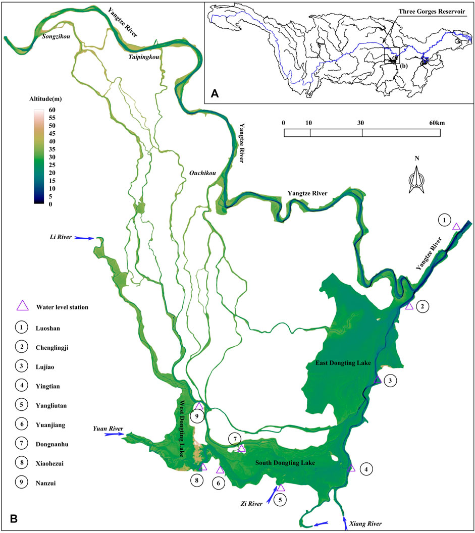
FIGURE 1. (A) Geographical position of Dongting Lake in the Yangtze River basin and (B) study area including the water level stations.
In this study, the daily average water level observation data of the abovementioned stations were collected to analyze the variation characteristics of low water level in different areas of Dongting Lake. In addition, the water level data of Luoshan station in the main stream of the Yangtze River were also collected for the analysis of the jacking relationship between the Yangtze River and Dongting Lake. The detailed information of the collected data is shown in Table 1.
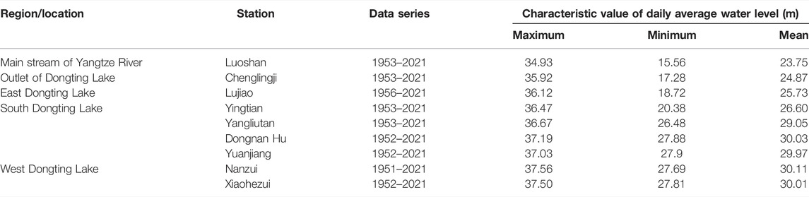
TABLE 1. Details about the collected data at different stations.
Results
Change in Annual Minimum Water Level
The changes in annual minimum water level are shown in Figure 2. The following can be seen from the figure:
(1) East Dongting Lake area. Before 1980, the annual minimum water level of Lujiao station in East Dongting Lake had shown a notable upward trend, rising from about 19.16 m in the 1950s to about 21.21 m in the 1980s, with an upward range of 2.05 m. From 1981 until the impoundment of the TGR, the annual minimum water level had little change. The multiyear average values of the minimum water level from 1981 to 1990 and 1991 to 2002 were 21.21 and 20.88 m, respectively, and the decline value was only 0.33 m as shown in Table 2. After the impoundment of the TGR, the annual minimum water level of Lujiao station slightly decreased by about 0.11 m from 2013 to 2021 compared with the multiyear average value from 1991 to 2002. The occurrence time of the lowest water level is relatively concentrated in the dry season from January to February before the flood season, accounting for about 60–70%, followed by December after the flood season, accounting for about 30–40%.
(2) South Dongting Lake area. From the 1950s until the impoundment of TGR, the annual minimum water level in South Dongting Lake had fluctuated from year to year, and there had been no notable change trend. The change ranges of the multiyear average values of Yuanjiang, Yangliutan, Dongnan Hu, and Yingtian stations in each period were only about 0.19, 0.38, 0.15, and 0.57 m, respectively. After the impoundment of the TGR, the minimum water level of Yingtian station has showed a notable downward trend. From 2013 to 2021, compared with that from 1991 to 2002, the multiyear average value has been decreased from 21.87 to 20.77 m, with the decline range of about 1.1 m. Except for Yingtian station, the annual average value of the lowest water level of Yuanjiang, Yangliutan, and Dongnan Hu stations has not decreased significantly, and the decline ranges are about 0.18, 0.02, and 0.01 m, respectively. The statistical values are shown in Table 3.
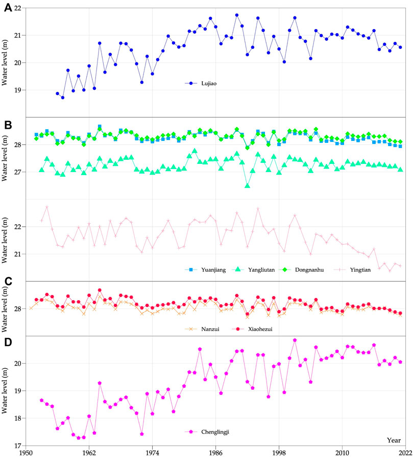
FIGURE 2. Historical change of annual minimum water level. (A) East Dongting Lake, (B) South Dongting Lake, (C) West Dongting Lake, and (D) the outlet of Dongting Lake.
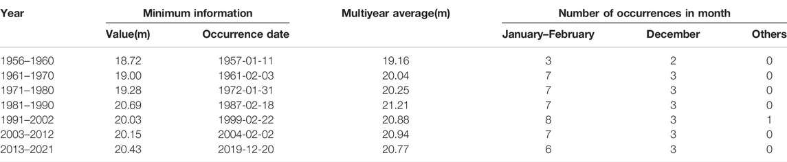
TABLE 2. Mean value and occurrence month distribution of minimum water level in East Dongting Lake.
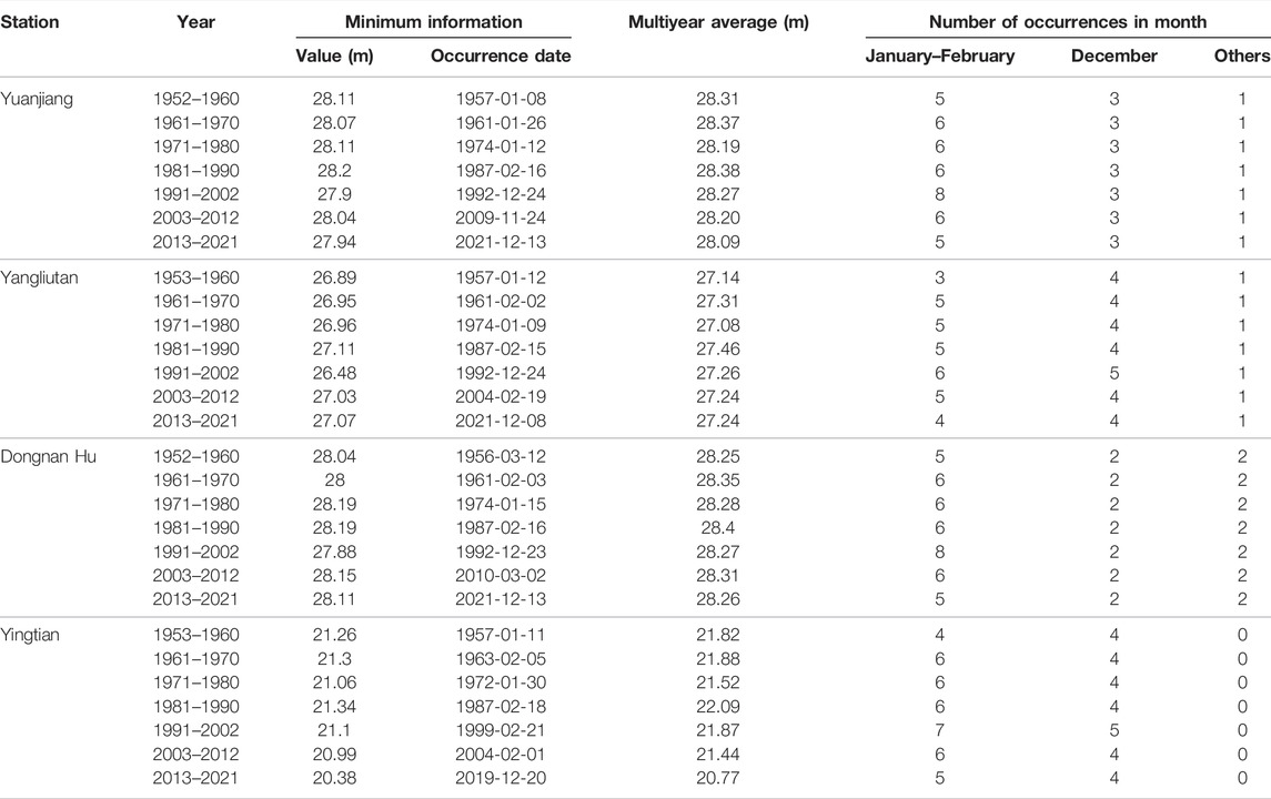
TABLE 3. Mean value and occurrence month distribution of minimum water level in South Dongting Lake.
The occurrence time of the lowest water level in South Dongting Lake is still relatively concentrated in the dry season from January to February before the flood season and December after the flood season, generally accounting for more than 80%. Yingtian station is almost concentrated in January to February before the flood season and December after the flood season, accounting for about 60% and 40%, respectively.
(3) West Dongting Lake area. Before the impoundment of TGR, the annual minimum water level of West Dongting Lake had fluctuated between years, and the variation range of each statistical period was about 0.2 m, among which the average value in the 1970s was the lowest, and the minimum values in Nanzui and Xiaohezui stations were 27.92 and 28.12 m, respectively, as counted in Table 4. After the impoundment of TGR, the annual minimum water level of West Dongting Lake has shown a weak downward trend. Compared with 1991–2002 before the impoundment, the mean values of Nanzui and Xiaohezui stations from 2013 to 2021 are 0.06 and 0.17 m, respectively. The lowest water level in the year is still concentrated in January to February before the flood season and December after the flood season. The lowest water levels of Nanzui and Xiaohezui stations are about 70% and 80% in January and February, respectively.
(4) Outlet of Dongting Lake. The change trend of Chenglingji station was basically the same as Lujiao station in East Dongting Lake before the 1980s, showing an upward trend, rising from 17.96 m in the 1950s to 19.78 m in the 1980s, with an increase range of 1.88 m. Since the 1980s, the minimum water level has shown little change and increased slightly. From 2013 to 2021, it increased by about 0.46 m compared with that in the 1980s. The statistical values are shown in Table 5. In terms of the occurrence, the lowest water level still occurs from January to February, accounting for about 70%, followed by March, accounting for about 20%, and the number of occurrences in December accounts for about 10%.
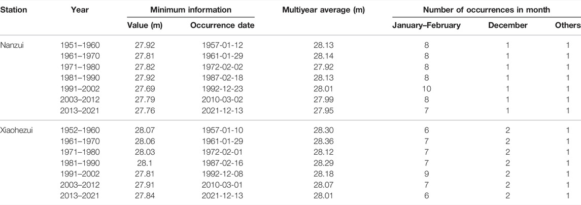
TABLE 4. Mean value and occurrence month distribution of minimum water level in West Dongting Lake.
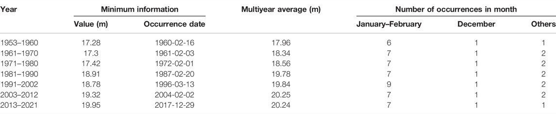
TABLE 5. Mean value and occurrence month distribution of minimum water level in the outlet of Dongting Lake.
Monthly Averaged Water Level in dry Season
Figure 3 shows the variation of monthly average water level at different stations in the Dongting Lake area in dry season. The following can be seen:
(1) East Dongting Lake area. Before the impoundment of TGR, the minimum monthly averaged water level of East Dongting Lake in the year occurred in January, and the average low water level in different statistical periods was between 22.04 and 22.31 m. After the impoundment of TGR, the minimum monthly average low water level in the year appears in December, but there is little difference from that in January. Compared with that before the impoundment of TGR, the average low water level of the East Dongting Lake had increased slightly in March and decreased in November and December, generally by 0.4 and 0.6 m, respectively.
(2) South Dongting Lake area. The minimum value of multiyear monthly average water level in the dry season of South Dongting Lake was also concentrated in January before the 1990s and mainly in December after the 1990s until now. After the impoundment of TGR, the average low water level of each station in South Dongting Lake was reduced in January, February, March, November, and December. Compared with 1991–2002, the maximum monthly average water level reduction of Yuanjiang, Yangliutan, and Dongnan Hu stations from 2013 to 2021 all occurred in December, shown as 0.36, 0.23, 0.27, and 0.83 m, respectively, while the maximum reduction of Yingtian station occurred in February, shown as 1.51 m.
(3) West Dongting Lake area. The monthly average water level in the dry season of the West Dongting Lake is the smallest, and it is basically concentrated in January and December. Compared with that before the impoundment of TGR, the average water level has decreased slightly from January to March, generally about 0.1 m. The decline was slightly more in November and December, especially in November. From 2013 to 2021, compared with 1991–2003, the average water level of Nanzui and Xiaohezui stations has been decreased about 0.35 m.
(4) The outlet of Dongting Lake. The monthly average water level of Chenglingji station is consistent with the overall law of the lake area, and the lowest water level basically occurs in January and December. Different from the stations in the lake area, the monthly average water level has increased from January to March due to the operation of TGR, while it has decreased in November and December due to the operation of the reservoir and the scouring of the main stream riverbed. Compared with the average value from 1991 to 2002, the average water level changes in January, February, March, November, and December from 2013 to 2021 are +0.68, +0.48, +0.85, −0.47 m, and −0.37 m, respectively.
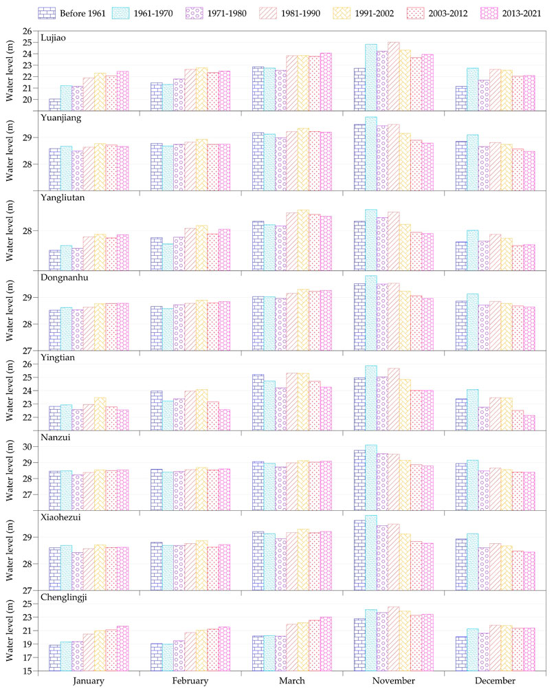
FIGURE 3. Variation of monthly average water level in dry season.
Monthly Average Water Level During the Storage Period of Three Gorges Reservoir
September and October are the main impounding periods of TGR. Figure 4 and Figure 5 show the changes in the average water level at different stations in Dongting Lake over the years in September and October, and Figure 6 shows the average values of different periods. The following can be seen from the figure and table:
(1) Compared with that before the impoundment of the TGR, the average water level of East Dongting Lake in September and October during the impoundment period of TGR has decreased by 0.54 and 1.27 m, respectively, in the first 10 years after the impoundment, and 1.66 and 1.0 m, respectively, in the next 9 years from 2013 to 2021.
(2) The decline in water level in South Dongting Lake in the first 10 years after the impoundment of the TGR is mainly in October compared with that before the impoundment, and the decline in water level in Yuanjiang, Yangliutan, Dongnan Hu, and Yingtian stations is 0.75, 0.68, 0.69, and 1.83 m, respectively. After 10 years of impoundment, that is, from 2013 to 2021, the water level decline is mainly in September, reduced by 0.58, 0.67, 0.56, and 1.50 m at Yuanjiang, Yangliutan, Dongnan Hu, and Yingtian stations, respectively.
(3) Similar to the South Dongting Lake, the average water level decreased in September and October after the impoundment of TGR in West Dongting Lake. The decline value in October of the first 10 years of impoundment was larger, about 0.8 m, and then in September, about 0.6 m, from 2013 to 2021.
(4) During the main impoundment period of TGR, the water level change of Chenglingji at the outlet of Dongting Lake is basically consistent with the overall water level change law of the lake area. In the first 10 years of TGR impoundment, it had mainly decreased in October, with an average decrease of about 1.68 m, and then decreased significantly in September from 2013 to 2021, about 1.31 m.
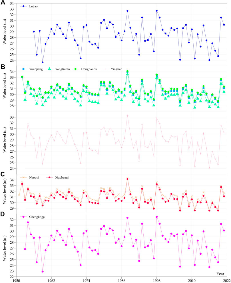
FIGURE 4. Variation of average water level in September. (A) East Dongting Lake, (B) South Dongting Lake, (C) West Dongting Lake, and (D) the outlet of Dongting Lake.
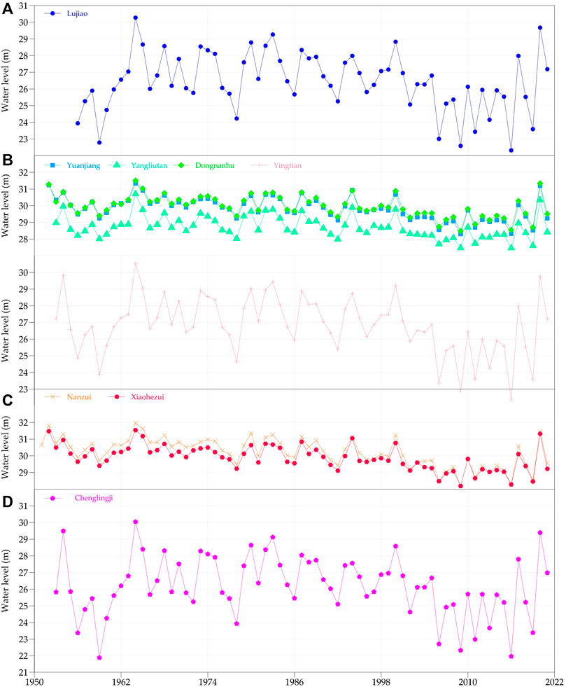
FIGURE 5. Variation of average water level in October. (A) East Dongting Lake, (B) South Dongting Lake, (C) West Dongting Lake, and (D) the outlet of Dongting Lake.
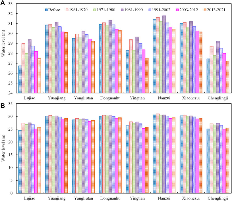
FIGURE 6. Monthly average water level change during different periods in main impoundment period of TGR. (A) September, (B) October.
Discussion
Based on the daily observation data of water level in Dongting Lake area from the 1950s to 2021, this study analyzes and obtains the change law of low water hydrological situation in different regions of Dongting Lake. The results show that the low water period in Dongting Lake area is mainly concentrated in January, February, and December, and the lowest water level in most regions of the lake area has no notable change trend in the year. The average water level in November and December has decreased slightly, but shows little change from January to March. However, the water level in the lake area has decreased significantly in September and October during the main storage period of TGR, which indicates that the storage of TGR has a great impact on the water level in the lake area. Compared with that before the impounding of the Three Gorges reservoir, the monthly average water level of East Dongting Lake, South Dongting Lake, West Dongting Lake, and Outlet decreased by 0.90, 0.67, 0.51, and 0.91 m, respectively, in September. The water level drop in October was even greater, 1.33, 0.81, 0.67, and 1.36 m, respectively, in East Dongting Lake, South Dongting Lake, West Dongting Lake, and the outlet. This is qualitatively consistent but quantitatively larger than the results obtained by an improved LSTM model (Zhang et al., 2022). This is mainly because the LSTM model takes the hydrological data from 2017 to 2018 as the training set, but the results in this study were based on the measured values.
In the dry season, due to the very small partial discharge of the three inlets of Jingjiang reach, the impact of reservoir impoundment on Dongting Lake area is mainly reflected in the decline of water level in the lake area caused by the water level drop in the main stream of the Yangtze River due to riverbed scouring and the decrease of discharge in the impoundment period. The jacking mechanism of the Yangtze River on the Dongting Lake area is very complex, which is discussed later.
Water Surface Gradient
Generally, with the change in the inflow of Dongting Lake and the confluence ratio of the river and lake, there will be great differences in the water jacking intensity and range. The water jacking range can be expressed by the change of water surface gradient at different stations and its relationship with the water level of Chenglingji station. Figure 7A shows the changes in daily average water surface gradient between different water level stations in the Dongting Lake area and Chenglingji station for many years. It can be seen from Figure 7A that there are great differences in the variation range of water surface gradient in different areas of Dongting Lake area, and the time and intensity of water jacking vary with the distance from Chenglingji.
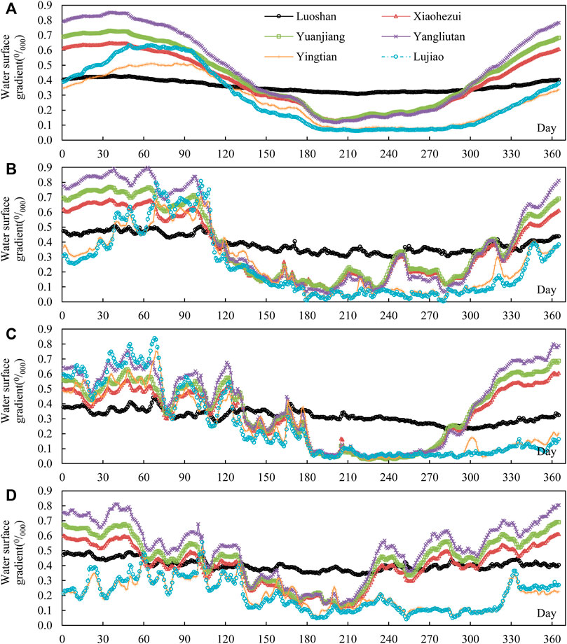
FIGURE 7. Variation of water surface gradient in the main stream of the Yangtze River and different regions of Dongting Lake area during the year. (A) Multiyear average, (B) 1975, (C) 1998, and (D) 2006.
Before April, Dongting Lake supported the main stream, and the water surface gradient in the lake area was greater than that in Chenglingji to Luoshan reach. The river and lake supported each other in May. From June to October, the main stream supported Dongting Lake, and the water surface gradient in the lake area was significantly less than that in Chenglingji to Luoshan reach. The water jacking in the lake area is the most notable in July. After the water retreats in October, the water surface gradient above Yangliutan and Chenglingji in the lake area is greater than that in Chenglingji to Luoshan section, which is not subject to the current jacking or is very little affected by the current jacking. The water surface gradient below Yingtian is less than that in Luoshan section, which is still subject to a certain degree of jacking. In addition, the gradient change between Yingtian to Chenglingji and Lujiao to Chenglingji is relatively close. In the flood stage of Dongting Lake before April, the gradient from Lujiao to Chenglingji is greater than that from Yingtian to Chenglingji. In other months, the gradient of Yingtian section is slightly greater than that of Lujiao section. The Lujiao section is close to the confluence, and the water jacking is more notable. The water surface gradient of Yingtian to Chenglingji and Lujiao to Chenglingji is quite different from that of other areas. With the increase in distance from the junction, the jacking effect becomes weaker, which is manifested in the increase of the water surface gradient. The water surface gradient of the upper part of Yangliutan is still slightly greater than that of the lake area below Yingtian in July, when the water flow is most strongly supported. From May to October, the water surface gradient in Dongting Lake area is smaller than that in Chenglingji to Luoshan section of the main stream, and the difference in water surface gradient is very small. The main stream has a great impact on the jacking of Dongting Lake. The water surface gradient in the lake area above Yangliutan is significantly lower than that in the dry season, and the water surface gradient value is very close, indicating that the range of water flow jacking reaches Yangliutan station at least.
With the different water inflow and water encounter of Dongting Lake and the main stream of the Yangtze River, there are great differences in the range and duration of water jacking in Dongting Lake area. Figure 7B to Figure 7D, respectively, plot the water jacking in 1975, 1998, and 2006. The year 2006 was a dry year, and the water flow jacking was mainly in the range of East Dongting Lake, while the South Dongting Lake and West Dongting Lake only had a short jacking in June and July, and the jacking range reaches Yangliutan. The year 1975 was the year of reclaimed water. Dongting Lake was affected by water jacking from April to November. The jacking of East Dongting Lake was obvious, and the jacking time of South Dongting Lake and West Dongting Lake was also long. The year 1998 was a flood year, and the jacking was not obvious before April. From June to September, the jacking effect of Dongting Lake was very strong. The water surface gradient from different water level stations to Chenglingji was almost the same, and the water surface gradient was only about 0.040/000. The jacking range reached the area above Yangliutan. After October, the water level of Yingtian was still strongly supported, and the jacking above Yangliutan was not obvious.
Water Level Correlation
The water jacking situation can also be analyzed by using the change in water level relationship between the two hydrological stations. When the water level of Chenglingji station is at a certain value, the water level of the upstream station changes greatly, and the water level is not affected by the water level change of Chenglingji station, and it is considered that there is no jacking effect or the jacking effect is very weak; when the water level of Chenglingji station exceeds this value, the water level of the upstream station changes linearly with the change of the water level of Chenglingji station, and the correlation between the two becomes better, and it can be considered that this water level is the lowest water level at which the upstream station begins to receive jacking, and the upstream begins to receive jacking.
The relationship between the annual average daily water level of Chenglingji station and Luoshan station is shown in Figure 8A. The two are well correlated. The water level of Chenglingji changes linearly with the water level of Luoshan, and the water level of Chenglingji is greatly affected by the jacking of Luoshan.
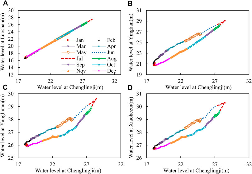
FIGURE 8. Water level correlation between Chenglingji and the stations in both main stream of the Yangtze River and Dongting Lake. (A) Main stream of the Yangtze River, (B) East Dongting Lake, (C) South Dongting Lake, and (D) West Dongting Lake.
Figure 8B shows the water level relationship between Yingtian station and Chenglingji station. It can be seen that the water level relationship is in a clockwise rope sleeve shape, and there is a great difference between the water level relationship in the rising stage and the falling stage. The water level difference in the rising stage is large, the water level difference in the falling stage is small, and the difference between the water level in the rising stage and the falling stage is large. In January, when the water level of Chenglingji is about 18 m, the corresponding Yingtian water level is about 21 m. When Chenglingji is at the same water level, the water level difference between the two stations changes greatly, and the Yingtian water level is less affected by the jacking of the main stream of the Yangtze River. From February to early April, when the water level of Chenglingji is about 21 m, the Dongting Lake supports the main stream of the Yangtze River, and the water level of Chenglingji rises in proportion to the water level of Yingtian. From late July to early October, the water level in Chenglingji drops. When the water level in Chenglingji is more than 25 m, the water level in Yingtian also drops with the same value. After late October, when the water level of Chenglingji is about 23 m, the water level of Chenglingji drops faster than that of Yingtian, and the jacking of the main stream to Dongting Lake decreases.
From the water level relationship between Yangliutan station in South Dongting Lake and Chenglingji station as shown in Figure 8C, it can be seen that the water level relationship is also in a clockwise rope sleeve shape. In January, when the water level of Chenglingji is about 18 m, the corresponding Yingtian water level is about 26 m. When Chenglingji is at the same water level, the water level difference between the two stations changes greatly, and the water level of Yangliutan is not affected by the jacking of the main stream of the Yangtze River. From February to May, when the water level of Chenglingji is below 24.5 m, Dongting Lake supports the main stream of the Yangtze River. The water level of Chenglingji rises with Yingtian water level. At the same time, the inflow of the main stream also increases, and the increase of Chenglingji water level is greater than that of Yangliutan. From late July to early October, the water level in Chenglingji falls. When the water level in Chenglingji is above 24.5 m, the water level in Yangliutan also falls with Chenglingji. After late October, when the water level in Chenglingji is below 24.5 m, there is a turning point in the decline of water level. The decline of water level in Chenglingji is faster, and the jacking of main stream to Dongting Lake is reduced.
From Figure 8D of the water level relationship between Xiaohezui station and Chenglingji station in West Dongting Lake, it can be seen that it is also in the shape of clockwise rope sleeve. When Chenglingji is at the same water level, the water level of Xiaohezui in the rising period and falling period is very different. In January, when the water level of Chenglingji is about 18 m, the corresponding Xiaohezui is about 26.7 m. When Chenglingji is at the same water level, the Xiaohezui water level changes greatly and is not affected by the jacking of the main stream of the Yangtze River. From February to May, when the water level of Chenglingji is below 25.5 m, Dongting Lake supports the main stream of the Yangtze River. The water level of Chenglingji rises with the rise of Yingtian water level. At the same time, the water inflow from the main stream also increases, and the increase in Chenglingji water level is greater than Xiaohezui. After late July, the water level in Chenglingji fell. When the water level in Chenglingji was about 25.5 m, there was also a turning point in the decline of water level at Xiaohezui. When the water level in Chenglingji was below 25.5 m, the decline of water level at Xiaohezui was significantly slower than that when the water level in Chenglingji was above 25.5 m, indicating that the support of the main stream to the Dongting Lake was weakened.
Jacking Effect of Main Stream on Lake Area
Overall, the main stream of the Yangtze River has a relatively obvious jacking effect on the Dongting Lake. The jacking effect is obvious from March to April. From November to February of the next year, the river and lake retreat, and the jacking effect is weakened. The Dongting Lake area can be affected by the jacking effect of the main stream, and the degree of influence increases along the way. The supporting range of the main stream to the lake includes almost the whole lake area from East Dongting Lake to West Dongting Lake. After the impoundment of TGR, the water surface gradient in the Dongting Lake area decreases, while the water surface gradient in the main stream of the Yangtze River increases. The jacking effect of the main stream on the Dongting Lake is enhanced, especially in the middle and low water period. The abovementioned phenomena are similar to some existing studies, such as the reduction of water surface gradient in the outlet section of Dongting Lake (Mao et al., 2013). For the period with the strongest jacking effect, there are also some inconsistencies. For example, Chen et al. (2020) believe that the maximum jacking effect occurs in February to April, which was a little different with the period from March to April in this study. However, the research based on the data from July to August shows that the mutual jacking strength of river and lake floods was weakened to varying degrees under different magnitudes of flow and water levels (Liu et al., 2019).
The analysis of influencing factors of flow jacking is complex. The research of Ni et al. (1992) shows that the flow jacking in the intersection area is mainly affected by the inlet angle, upstream water depth, confluence ratio, and the flow of main stream or tributary. When the inlet angle is given, the three variables of upstream water depth, confluence ratio, and the flow of main stream or tributary are the core influencing factors. In addition, it is also related to river roughness, river width, bottom slope, and other factors. In addition, river scouring and silting will also have a certain impact on the upstream flow jacking, and water conservation projects may cause changes in the abovementioned factors, thus affecting the flow jacking. The recent study shows that the operation of the TGR has had an important impact on the jacking relationship between the Yangtze River and Dongting Lake (Duan et al., 2019). The water level and flow in the intersection area of the Yangtze River and Dongting Lake have decreased, and the mutual jacking intensity has also been weakened. Further research on jacking impacts needs to integrate the aforementioned factors for more in-depth research.
Conclusion
Based on the daily average water level data, the variation law of low flow hydrological situation in different areas of Dongting Lake from the 1950s to 2021 was analyzed in this study. The results show that:
(1) The annual minimum water level of Dongting Lake stations generally occurs from January to February, accounting for 60–80% of all years, followed by December, accounting for 20–40%. Before the impoundment of the Three Gorges Reservoir, except that the annual minimum low water level of East Dongting Lake (Lujiao station) and outlet (Chenglingji station) increased significantly from the 1950s to the 1980s, there was little change in other stations. After the impoundment, the annual minimum water level of Yingtian station in South Dongting Lake shows an obvious decline, while the decline value of other stations is small and the downward trend is not notable.
(2) From the change of monthly average water level in the dry season, the driest month in the 1990s and before was generally concentrated in January, and after the 1990s, it was generally concentrated in December. After the impoundment of the Three Gorges Reservoir, the low water level of Dongting Lake decreased in November and December. From January to March, affected by the increase of the discharge of the Three Gorges Reservoir during the dry season and the jacking effect of the low water level of the main stream of the Yangtze River, the low water level of Chenglingji and East Dongting Lake increased, until the jacking effect of the main stream of the Yangtze River in South Dongting Lake and West Dongting Lake basically disappeared, and the water level decreased mainly below the water level.
(3) During the main impoundment period of the Three Gorges Reservoir, the water level in all regions of Dongting Lake decreased significantly. In the first 10 years after the impoundment, the decline value was relatively large in October, and then greater in September in the next 9 years. From different regions, the closer to the main stream of the Yangtze River, the greater the water level drop is.
(4) The jacking effect of the main stream of the Yangtze River has a very important impact on the low water level in the Dongting Lake area, and the influencing factors are complex. Further research needs to analyze the changes in discharge and water level, confluence ratio of rivers and lakes, hydraulic engineering, and river erosion and deposition.
Data Availability Statement
The original contributions presented in the study are included in the article/Supplementary Material; further inquiries can be directed to the corresponding author.
Author Contributions
HG contributed to the conception of the study and completed the main analysis work. LZ contributed significantly to data analysis and manuscript preparation. RL, CD, SY, and OZ helped perform the analysis with constructive discussions.
Funding
This research was funded by the National Natural Science Foundation of China [grant numbers U2240224 and U2240206].This research was supported by the “Research and innovation team of river and lake protection and regulation in the middle and lower reaches of the Yangtze River,” whose leader is Shiming Yao.
Conflict of Interest
The authors declare that the research was conducted in the absence of any commercial or financial relationships that could be construed as a potential conflict of interest.
Publisher’s Note
All claims expressed in this article are solely those of the authors and do not necessarily represent those of their affiliated organizations, or those of the publisher, the editors, and the reviewers. Any product that may be evaluated in this article, or claim that may be made by its manufacturer, is not guaranteed or endorsed by the publisher.
References
Bing, J., Deng, P., Zhang, D., and Liu, X. (2020). Influence of Three Gorges Reservoir Operation on Hydrological Regime of Poyang Lake. Yangtze River 51 (03), 87–93. doi:10.16232/j.cnki.1001-4179.2020.03.015
Chen, D., Qu, G., Guo, X., and Yu, M. (2020). Study of the Supporting and Falling Impact of Dongting Lake on the Lower Jingjiang River before and after Construction of Three Gorges Dam. J. Sichuan Univ. Eng. Sci. Ed. 52 (2), 86–94. doi:10.15961/j.jsuese.201900385
Cheng, J., Xu, L., Feng, W., Fan, H., and Jiang, J. (2019). Changes in Water Level Regimes in China's Two Largest Freshwater Lakes: Characterization and Implication. Water 11 (5), 917. doi:10.3390/w11050917
Cheng, J., Xu, L., Wang, Q., Yan, B., Wan, R., Jiang, J., et al. (2017). Temporal and Spatial Variations of Water Level and its Driving Forces in Lake Dongting Over the Last Three Decades. J. Lake Sci. 29 (04), 974–983. doi:10.18307/2017.0421
Cheng, J., Xu, L., Wang, X., Jiang, J., and You, H. (2018). Assessment of Hydrologic Alteration Induced by the Three Gorges Dam in Dongting Lake, China. River Res. Applic. 34 (7), 686–696. doi:10.1002/rra.3297
Dai, L., Liu, H., Li, W., and Tang, Z. (2020). “Trend and Abrupt Analysis of Dongting Lake Water Level and its Driving Forces Using Mann-Kendall Approach,” in Fourth International Conference on Energy Engineering and Environmental Protection, Xiamen, November 19–21, 2019. doi:10.1088/1755-1315/467/1/012140
Dai, X., Yang, G., Wan, R., and Li, Y. (2018). The Effect of the Changjiang River on Water Regimes of its Tributary Lake East Dongting. J. Geogr. Sci. 28 (8), 1072–1084. doi:10.1007/s11442-018-1542-5
Duan, Y., Li, J., Lv, D., Wang, D., Dai, W., and Liu, W. (2019). Hydrological Conditions and the Mutual Supporting Effects at the Intersection Area of Dongting Lake and Yangtze River under the Operation of the Three Gorges Reservoir. Resour. Environ. Yangtze Basin 28 (10), 2471–2483. doi:10.11870/cjlyzyyhj201910019
Fang, J., Li, Y., Wang, D., and Xie, S. (2022). Modified Hydrological Regime on Irrigation and Water Supply in Lake Areas: A Case Study of the Yangtze River-Dongting Lake. Front. Earth Sci. 10, 16. doi:10.3389/feart.2022.888729
Han, Q., Zhang, S., Huang, G., and Zhang, R. (2016). Analysis of Long-Term Water Level Variation in Dongting Lake, China. Water 8 (7), 306. doi:10.3390/w8070306
Hu, J.-Y., Xie, Y.-H., Tang, Y., Li, F., and Zou, Y.-A. (2018). Changes of Vegetation Distribution in the East Dongting Lake after the Operation of the Three Gorges Dam, China. Front. Plant Sci. 9, 582. doi:10.3389/fpls.2018.00582
Huang, F., Ochoa, C. G., Guo, L., Wu, Y., and Qian, B. (2021). Investigating Variation Characteristics and Driving Forces of Lake Water Level Complexity in a Complex River-Lake System. Stoch. Environ. Res. Risk Assess. 35 (5), 1003–1017. doi:10.1007/s00477-020-01907-9
Huang, Q., Sun, Z., and Jiang, J. (2011). Impacts of the Operation of the Three Gorges Reservoir on the Lake Water Level of Lake Dongting. J. Lake Sci. 23 (03), 424–428. doi:10.18307/2011.0316
Huang, Q., Sun, Z., Opp, C., Lotz, T., Jiang, J., and Lai, X. (2014). Hydrological Drought at Dongting Lake: Its Detection, Characterization, and Challenges Associated with Three Gorges Dam in Central Yangtze, China. Water Resour. Manage 28 (15), 5377–5388. doi:10.1007/s11269-014-0807-8
Jiang, H., Qian, Z., Zhang, S., Huang, B., and Li, X. (2019). The Effect of the Chenglingji Integrated Hub on the Elevation of the Water Level in the Dongting Lake Area. China Rural Water and Hydropower (6), 29–34. doi:10.3969/j.issn.1007-2284.2019.06.006
Lai, X., Chen, H., Hou, Y., Finlayson, B., Li, M., and Chen, J. (2021). Lowering Water Level of Dongting Lake of the Mid-Yangtze River in Response to Large-Scale Dam Construction: A 60-year Analysis. Geomorphology 391, 107894. doi:10.1016/j.geomorph.2021.107894
Lai, X., Liang, Q., Jiang, J., and Huang, Q. (2014). Impoundment Effects of the Three-Gorges-Dam on Flow Regimes in Two China's Largest Freshwater Lakes. Water Resour. Manage 28 (14), 5111–5124. doi:10.1007/s11269-014-0797-6
Liang, C., Li, H., Lei, M., and Du, a. Q. (2018). Dongting Lake Water Level Forecast and its Relationship with the Three Gorges Dam Based on a Long Short-Term Memory Network. Water 10 (10), 1389. doi:10.3390/w10101389
Liu, Y., Li, J., Li, H., Yang, B., and Liu, W. (2019). Effect of the Three Gorges Reservoir Operation on Flood Inter-Jacking in the Confluence Section of Rivers and Lakes. J. Water Resour. Water Eng. 30 (2), 114–121,129. doi:10.11705/j.issn.1672-643X.2019.02.18
Liu, Z., Feng, X., Peng, W., and Zhang, M. (2015). Effect of Chenglingji Low Water Level Decrease on Dongting Lake Xiangjiang Tail Fairway. Port Waterw. Eng. (06), 127–130+151. doi:10.3969/j.issn.1002-4972.2015.06.026
Mao, B., Wu, Z., Mei, J., and Tao, W. (2013). Confluence Relationship Changes of Yangtze River and Dongting Lake since Impoundment of Three Gorges Project. J. Hydroelectr. Eng. 32 (5), 48–57.
Meng, X., Liao, X., and Li, X. (2014). Study on Characteristics of Water Level Variation in Dongting Lake and its Influences. Yangtze River 45 (13), 17–21. doi:10.16232/j.cnki.1001-4179.2014.13.016
Ni, J., Wang, G., and Zhang, G. (1992). Discussion on Hydraulic Calculation of Confluence Reach. Shuili Xuebao (07), 51–56. doi:10.13243/j.cnki.slxb.1992.07.009
Sun, Z., Huang, Q., Opp, C., Hennig, T., and Marold, U. (2012). Impacts and Implications of Major Changes Caused by the Three Gorges Dam in the Middle Reaches of the Yangtze River, China. Water Resour. Manage 26 (12), 3367–3378. doi:10.1007/s11269-012-0076-3
Wang, D., Zhang, S., Wang, G., and Wang, H. (2020). Quantitative Assessment of Water Stage Changes of Poyang Lake in Dry Period and its Influencing Factors. J. Hydroelectr. Eng. 39 (03), 1–10. doi:10.11660/slfdxb.20200301
Wang, H., Zhu, Y., Zha, H., and Guo, W. (2021). Quantitative Assessment of Water Level Regime Alterations during 1959-2016 Caused by Three Gorges Reservoir in the Dongting Lake, China. Water Supply 21 (3), 1188–1201. doi:10.2166/ws.2020.369
Yang, Z., Zhu, Z., Huai, W., and Bai, F. (2018). Study on the Influence of Poyang Lake Hydraulic Project on Hydrodynamics and Water-Quality in Wet and Dry Year. J. Hydraulic Eng. 49 (02), 156–167. doi:10.13243/j.cnki.slxb.20170577
Yuan, Y., Zeng, G., Liang, J., Huang, L., Hua, S., Li, F., et al. (2015). Variation of Water Level in Dongting Lake over a 50-Year Period: Implications for the Impacts of Anthropogenic and Climatic Factors. J. Hydrol. 525, 450–456. doi:10.1016/j.jhydrol.2015.04.010
Zhang, M., Feng, X., Liu, Z., and Li, W. (2015). Impact on Dongting Lake Channel Caused by the Change of Flow and Sediment Environment after Three Gorges Project Impoundment. Adv. Water Sci. 26 (03), 423–431. doi:10.14042/j.cnki.32.1309.2015.03.013
Zhang, R., Dai, L., Dai, H., Liu, Y., Cai, Z., and Liu, F. (2022). Spatial Heterogeneity Analysis of the Impact of the Three Gorges Reservoir Impounding on the Water Level of Dongting Lake Based on the Improved LSTM Model. Water Resour. Hydropower Eng. 53 (2), 11. doi:10.13928/j.cnki.wrahe.2022.02.010
Zhou, H., Mao, D., and Liu, P. (2014). The Investigation on Water Lever of East Dongting Lake Affected by Three-Gorge Reservoir. Trans. Oceanol. Limnol. (04), 180–186. doi:10.13984/j.cnki.cn37-1141.2014.04.025
Zhou, L., Li, J., Tang, X., Zhou, Y., and Li, X. (2017). Dynamics of Water Level of Lake Dongting during the Past 60 Years and the Associated Driving Factors. J. Glaciol. Geocryol. 39 (03), 660–671. doi:10.7522/j.issn.1000-0240.2017.0075
Keywords: Dongting Lake, Three Gorges Reservoir, low water level, lake–river relationship, jacking impact
Citation: Ge H, Zhu L, Long R, Deng C, Yin S and Zhang O (2022) Spatial and Temporal Evolution Characteristics of Low Water Level Based on 70 years’ Measured Data: A Case Study of Dongting Lake in China. Front. Earth Sci. 10:933568. doi: 10.3389/feart.2022.933568
Received: 01 May 2022; Accepted: 23 June 2022;
Published: 22 July 2022.
Edited by:
Xijun Lai, Nanjing Institute of Geography and Limnology (CAS), ChinaReviewed by:
Lingquan Dai, China Three Gorges Corporation, ChinaYuan-Pin Chang, National Sun Yat-sen University, Taiwan
Xue Dai, Hohai University, China
Copyright © 2022 Ge, Zhu, Long, Deng, Yin and Zhang. This is an open-access article distributed under the terms of the Creative Commons Attribution License (CC BY). The use, distribution or reproduction in other forums is permitted, provided the original author(s) and the copyright owner(s) are credited and that the original publication in this journal is cited, in accordance with accepted academic practice. No use, distribution or reproduction is permitted which does not comply with these terms.
*Correspondence: Lingling Zhu, zhull1012@foxmail.com