 Ali Aydogdu1*
 Romain Escudier2
 Jaime Hernandez-Lasheras1,3
 Carolina Amadio4
 Jenny Pistoia1
 Nikolaos D. Zarokanellos3
 Gianpiero Cossarini4
 Elisabeth Remy2
 Baptiste Mourre3,5
- 1CMCC Foundation - Euro-Mediterranean Center on Climate Change, Bologna, Italy
- 2Observations pour Les Systèmes D’analyse et de Prévision, Mercator Ocean International - MOi, Toulouse, France
- 3Balearic Islands Coastal Observing and Forecasting System - SOCIB, Palma de Mallorca, Spain
- 4National Institute of Oceanography and Applied Geophysics - OGS, Trieste, Italy
- 5Mediterranean Institute for Advanced Studies (IMEDEA) - CSIC-UIB, Esporles, Spain
We present an impact assessment of temperature and salinity glider observations on physical analysis and forecasting systems operating in the Western Mediterranean Sea through one-year-long coordinated experiments. A unique set of glider observations including data from several endurance lines provided by different institutions is assimilated in the three systems. Results are compared against an assimilation-free run and an assimilative-run that with each systems’ default configuration. Moreover, an additional biogeochemical analysis system is forced by two physical runs with and without the assimilation of glider observations. First of all, we demonstrate that glider data assimilation has an overall positive impact on the state estimation of the Western Mediterranean Sea, independently of the system employed and the pre-processing approach used to ingest the glider measurements. Secondly, we show that it helps improve the representation of mesoscale structures, in particular the location and size of an intense anticyclonic eddy observed in the Balearic Sea. Thirdly, the geostrophic currents and transport of Winter Intermediate Water in the Ibiza Channel are also improved. Finally, the adjustment of the mixing after glider data assimilation in the physical system translated to a better estimate of chlorophyll distribution in the upper layer of the biogeochemical system. Leading to the same order of magnitude of improvement in the different forecasting systems, this intercomparison exercise provides robustness of the obtained impact assessment estimates. It also allows us to identify relative strengths and weaknesses of these systems, which are useful to identify future ways of improvement. Overall, this study demonstrates the value of repeated glider observations collected along endurance lines for regional ocean prediction.
1 Introduction
Ocean underwater gliders (hereafter gliders) have been observing the world ocean since the beginning of the 2000s (Lee and Rudnick, 2018) and take part as an important part of the Global Ocean Observing System (GOOS; Moltmann et al., 2019; Liblik et al., 2016). The growing network of gliders, which has been operated by many teams around the world, plays an important role for the understanding of the ocean state, variability and changes, especially in areas that connect the open basin with the coastal environment (Davis et al., 2002; Testor et al., 2010; Rudnick, 2016). Gliders have the ability to operate under all-weather conditions and sample the ocean where it is impractical for human access, such as in the middle of a hurricane or under sea ice (Testor et al., 2019; Duguid and Camilli, 2021; Zarokanellos et al., 2022; Patmore et al., 2024). They help to investigate physical and biogeochemical processes, covering extreme events and climate signals (Glenn et al., 2016; Todd et al., 2011; Zaba and Rudnick, 2016; Rudnick et al., 2017). They are especially crucial for observing the boundary currents (e.g., Todd and Locke-Wynn, 2017), tracking the storms (Glenn et al., 2016), identifying water masses formation and transformation (Våge et al., 2018), resolving mesoscale and submesoscale phenomena (Hristova et al., 2014) and coastal processes (Benveniste et al., 2019). An exhaustive list of the applications of the underwater gliders can be found in Rudnick (2016) and Testor et al. (2019).
The Mediterranean Sea has been characterised by high mesoscale activity (Bosse et al., 2015; Escudier et al., 2016; Bonaduce et al., 2021), different water masses (Özsoy et al., 2014; Pinardi et al., 2015), deep convection (Testor et al., 2018) and frontal processes (Hernández-Carrasco and Orfila, 2018), sea strait dynamics (Aydoğdu et al., 2018; Sanchez-Roman et al., 2018) and tidal dynamics (Sannino et al., 2004), making the basin an ideal testbed to assess the impact of different observing systems. The Western Mediterranean basin is one of the regions in the world that is most intensively observed by gliders. Several endurance and quasi-endurance glider lines have been established in the last decade to provide repeated monitoring in key observing areas with high biodiversity importance (Tintoré et al., 2019; Mourre et al., 2022). These are Nice-Calvi, Marseille-Menorca, Menorca-Sardinia, Mallorca and Ibiza channels and Mallorca to the Algerian coast. The extensive glider network in the basin allows to study these different oceanic phenomena (Zarokanellos et al., 2022; Heslop et al., 2012; Margirier et al., 2020) from an observational point of view or in combination with numerical simulations (Garcia-Jove et al., 2022). Gliders also allow to validate and improve ocean circulation models through data assimilation, being a good company or alternative to traditional research vessel campaigns (Dobricic et al., 2010; Hernandez-Lasheras and Mourre, 2018).
The vertical physical and biogeochemical profiles provided by gliders are incorporated into the ocean analysis and reanalysis systems from coastal to regional and global scales to improve the ocean state estimation, forecast initialization1 and reconstruction of the past state (Storto et al., 2019). Dobricic et al. (2010) assimilated observations of temperature, salinity, and vertically averaged velocity from a single glider in the northern Ionian Sea where the highly dynamic Atlantic Ionian Stream enters. They found local improvements in temperature, salinity, velocity, and surface elevation fields. Furthermore, the assimilation of glider observations rapidly generates remote impacts that last several months. Similarly, Hayes et al. (2019) assimilated a single glider in the south of Cyprus and found that a spatial scale of 40-50 km around the glider in which the forecast skill is improved by 15%. The controllability of glider platforms at sea can also be exploited to adapt their path to sample areas of increased interest (Lermusiaux, 2007). In this line, Mourre and Alvarez (2012) demonstrated the benefit of piloting a glider through a real-time adaptive sampling scheme to reduce predicted ocean temperature uncertainties in the Ligurian Sea. The error was reduced by 18% compared to a control run assimilating glider observations collected along a predetermined path. In the U.S. West Coast, offshore of Oregon and Washington, Pasmans et al. (2019) showed that the assimilation of glider observations alone creates unphysical eddies in the vicinity of the glider transect which can be prevented by the combined assimilation of surface and subsurface observations. Kerry et al. (2018) assimilated gliders along with the other observations in the East Australian Current (EAC) system. They showed that the information from the gliders not only imposes strong constraints on the depth of an eddy but also strongly alters its meridional extension.
Synchronous measurements from fleets of several gliders, up to 15 vehicles, were also proven to be successfully assimilated in numerical models (Shulman et al., 2009; Pan et al., 2011; Gangopadhyay et al., 2013; Mourre and Chiggiato, 2014; Hernandez-Lasheras and Mourre, 2018). Vargas et al. (2019) conclude that the assimilation of glider data in the global ocean forecasting system was crucial to improve the pre-storm vertical stratification during hurricane Michael in 2020. However, the assimilation frequency in the current setup, once a day, was insufficient to capture the rapid cooling of the surface layer. Liu et al. (2023) performed numerical experiments assimilating satellite and glider observations to study Hurricane Isaias in 2020. They showed that assimilating glider observations with broad spatial and temporal coverage along Isaias’ track in addition to satellite observations further increased Isaias’ intensity forecast. Observations from gliders are used also to develop new algorithms for data assimilation. For example, Pan et al. (2011) used glider observations to test a 3DVar scheme in its hybrid and ensemble formulation. Halliwell et al. (2020) performed an observing system simulation experiment to assess different glider array setups to predict tropical cyclones.
The assimilation of biogeochemical observations from gliders is still in its early stages and very few examples have been published. Kaufman et al. (2018) assimilated chlorophyll and particulate organic carbon in the 1D model of the Ross Sea showing improvements in phytoplankton dynamics and ecosystem processes such as depth-integrated primary production and carbon export. Chlorophyll and oxygen from BGC-glider are assimilated in the preoperational model of the North-Western European shelf to constrain the phytoplankton spring bloom with positive impacts on biogeochemical processes such as remineralization and nitrification rates (Skákala et al., 2021). Ford et al. (2022) performed an observing system experiment for coastal ocean ecosystems in the western English Channel integrating real-time glider data with model forecasts to predict the spring phytoplankton bloom. Biogeochemical observations from gliders are used also to validate models in coastal areas and open seas (Jones et al., 2016; Thomalla et al., 2017; Many et al., 2021) where chlorophyll is typically the most used variable.
There has been a dedicated effort in the last two decades for ocean model intercomparison under World Climate Research Programme (WCRP; Griffies et al., 2016) and data assimilation system intercomparison under Global Ocean Data Assimilation Experiment (GODAE, now OceanPredict; Hernandez et al., 2009). Balmaseda et al. (2015) reports the intercomparison of several global ocean reanalysis to estimate uncertainty in different oceanic variables and regions. Intercomparison experiments to assess the impact of a specific observing network are also emerging. For example, Martin et al. (2020) examined the impact of satellite sea surface salinity in two global operational forecasting systems.
In this study, our goal is to evaluate the impact of the Western Mediterranean Sea extended glider network on four European analysis and forecasting systems. The basin is one of the dynamically very active regions in the Mediterranean Sea. The Gulf of Lion is a convection area where deep water is ventilated, and the surface layer gets nutrient rich waters. Mesoscale eddy activity also modifies the local water mass properties, which may have various consequences for the sea state and ecosystem. The circulation in the region is a part of the exchange mechanism with the Atlantic Ocean through the Gibraltar Strait that regulates the water budget in the entire Mediterranean Sea. For the assessment, a coordinated experiment is performed using a unique glider dataset assimilated in all systems during a one-year-long simulation. We have applied a detailed validation, focusing, besides the widely used statistical metrics, on the capacity of the different systems to represent physical processes and dynamical features. More specifically we concentrate on the transport processes in the Ibiza Channel and impact of assimilation on the evolution of an intense and long-lived anticyclonic eddy. Moreover, we show the impact of temperature and salinity assimilation on biogeochemistry (BGC) via uncoupled forcing of the BGC system with the estimates of the physical system and discuss its implications.
In Section 2, we will introduce the analysis systems that were used in this study. We also introduce the observations that were used for validation along with their preparation procedures. In Section 3, we will present the findings using different metrics that are defined in Section 2. The discussion is carried out separately in Section 4 where the final conclusions are also drawn.
2 Materials and methods
The Western Mediterranean Sea is covered and monitored by different analysis and forecasting systems from the Copernicus Marine Service namely, Mediterranean physical component (MedFS; https://medfs.cmcc.it) and biogeochemical component (MedBFM; https://medeaf.ogs.it), and Iberia Biscay Irish (IBI; https://doi.org/10.48670/moi-00027) physical component, as well as the Western Mediterranean Operational forecasting system (WMOP; https://www.socib.es/?seccion=modelling&facility=forecast) from SOCIB (Figure 1A). We use a unique set of glider observations for all the different physical systems to investigate their impact on the quality of the ocean analysis estimates. Moreover, the impact on the biogeochemical estimates forced by the physical analysis is assessed. Here we consider numerical experiments spanning an entire year (2017), which is a distinguishing characteristic of this study from most of the previous glider data assimilation studies that focus on specific campaigns for short periods. In this section, we describe the datasets and systems as well as methodologies applied for pre-processing, quality check and validation.
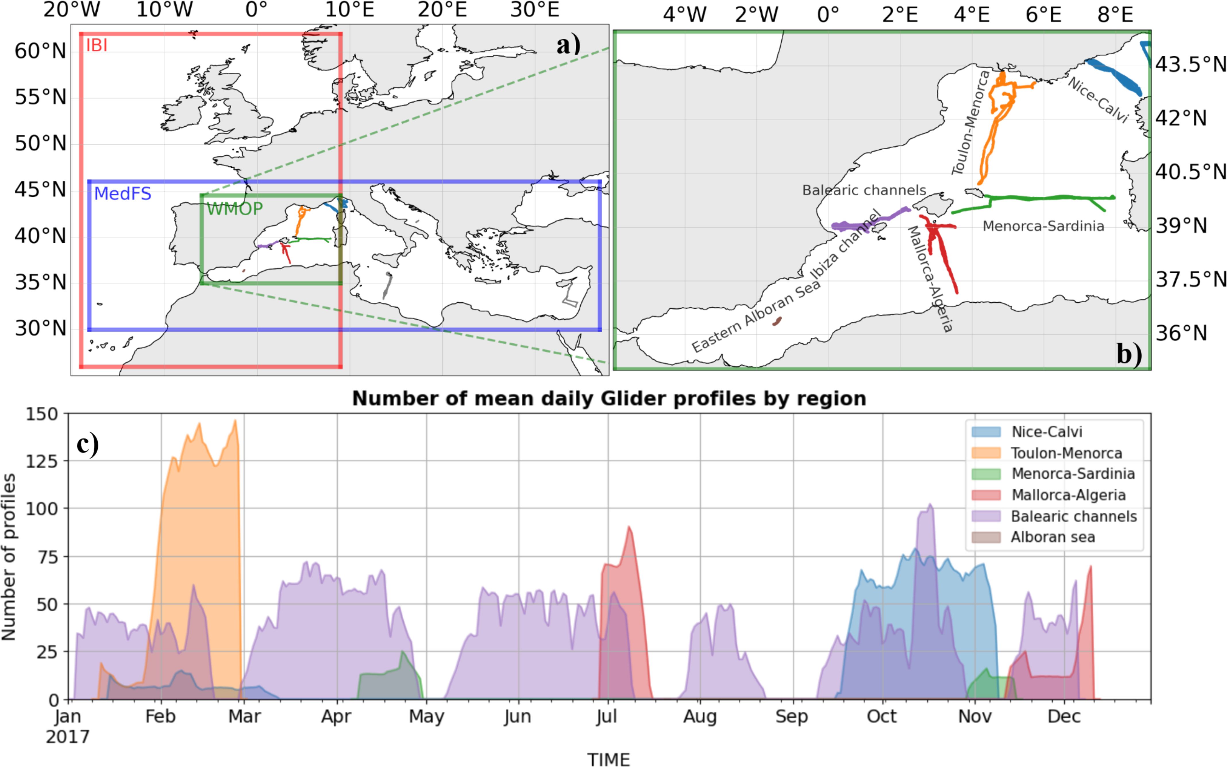
Figure 1. The model domain of analysis and forecasting systems employed in the study is shown in the (A) IBI in red, MedFS in blue and WMOP in green. The glider transects available in the Mediterranean Sea in the Copernicus Marine data store in the entire 2017 are also shown. (B) A zoom in the Western Mediterranean region, where the intercomparison is performed, is depicted in a) to highlight different transects. (C) the timeline of the availability daily glider profiles (7-day running mean) in each transects highlighted in the zoomed panel.
2.1 Gliders in the Mediterranean sea in 2017
Various institutions provided glider observations in the entire Mediterranean Sea in 2017. Figure 1 shows the spatial distribution of the data for each transect with a focus on the western basin in which the largest volume of glider observations is available. There are also gliders operated in the Adriatic Sea by OGS, in the Sicily Strait by INSU and in Southern Levantine by OC-UCY. The temporal distribution of the number of profiles in the different transects in the Western Mediterranean is shown in Figure 1C. We note that a 7-day running mean is shown here and that high number of profiles are due to the fact that gliders dive to lower depths, making more up and down casts. In 2017, SOCIB performed various missions in the Western Mediterranean Sea. The SOCIB Canales endurance line provided observations in the Balearic Channels (>300 glider days; Heslop et al., 2012; Zarokanellos et al., 2023) and the Alnitak 2017 mission collected data south of Mallorca. Furthermore, SOCIB, in collaboration with CNR, University of Parthenope and IMEDEA in Italy and Spain, performed several missions between Menorca and Sardinia (SMART quasi endurance line; Pessini et al., 2018; Mourre et al., 2022), between Mallorca and the Algerian basin (ABACUS quasi endurance line; Cotroneo et al., 2016, 2019; Zarokanellos et al., 2023) and in the eastern Alboran Sea (IRENE-CALYPSO mission). The regular glider lines between Menorca and Toulon, and between Corsica and Nice, are maintained by the French institutions Ifremer, CNRS, ENSTA and INSU through the MOOSE observing network (Margirier et al., 2017; Coppola et al., 2019). Finally, CMRE (NATO-STE) also deployed gliders in the Ligurian Sea. The glider temperature and salinity data used in this study is made available by In-Situ thematic assembly centre (TAC) through the Copernicus Marine data store.
This research is carried out as part of the Horizon 2020 EuroSea project. Within Eurosea, two distinct tasks were undertaken to evaluate the impact of glider and float observations that are available in the In-Situ TAC in the Mediterranean Sea and Iberia Biscay Irish regions. A workshop2 has been organised to discuss the best practices for using the glider observations for validation and assimilation to improve the analysis and forecasting systems. Experts from OceanGliders, Euro-Argo, OceanObs and OceanPredict programmes participated to initiate a collaboration between marine observation specialists and data assimilation practitioners. The main issues addressed were:
a. the best practices in use of glider and floats in-situ observations by operational forecasting systems
b. the accessibility to the glider/Argo floats observations in near-real time (NRT) and delayed time (DT) mode
c. the quality control (QC) in the assimilation systems
The focus of the workshop was to open a debate on how to improve data flow through the TACs and reinforce MFCs to achieve the best estimate of the ocean state using the best quality observations. This workshop, along with the subsequent interactions in the community, has been instrumental in shaping the future of the glider data assimilation under OceanGliders programme which will hopefully facilitate further improvements in the use of glider observations in the analysis/reanalysis systems.
2.2 Analysis and forecasting system configurations
We employed three ocean and one biogeochemical analysis and forecasting systems that overlap in the Western Mediterranean Sea. Major characteristics of all the physical systems used in this study, MedFS, IBI and WMOP, are significantly different and listed in Table 1. In the following subsections, we will outline their key features that are important for this investigation. Main characteristics of MedBFM are also summarized.
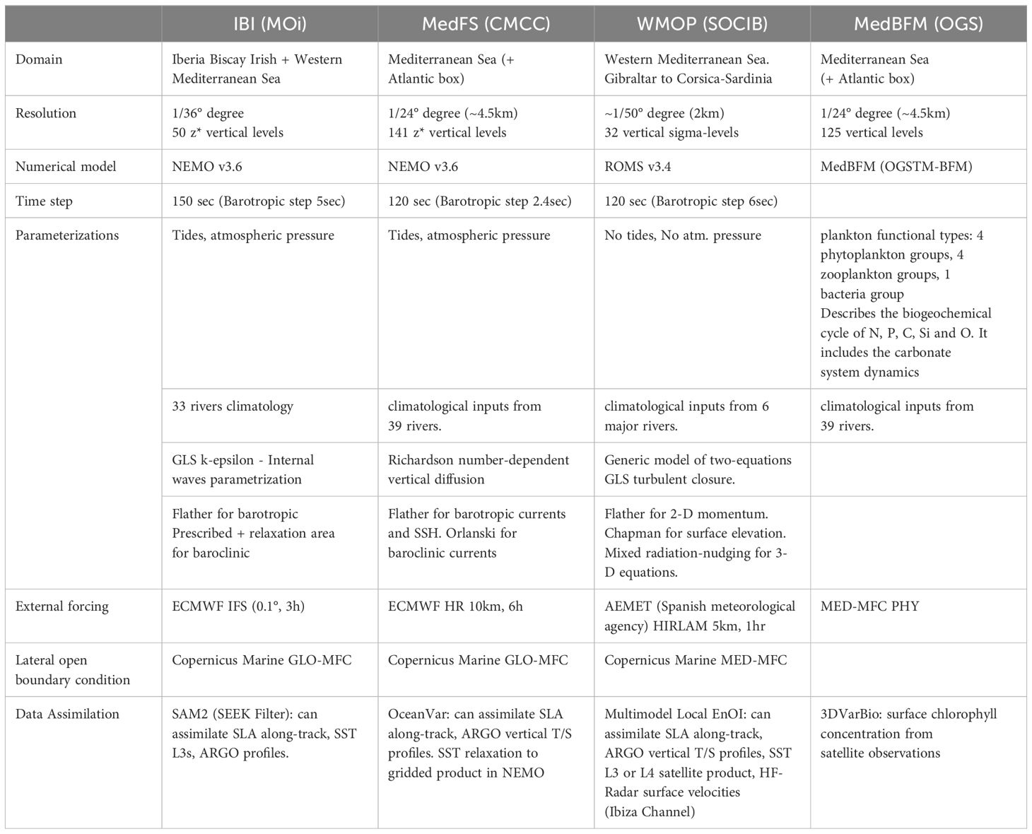
Table 1. The main characteristics of the analysis and forecasting system configurations involved in the intercomparison developed and maintained by MOi, CMCC and WMOP.
In brief, IBI and MedFS are designed for regional applications and adopt NEMO as their ocean model while a high resolution ROMS implementation in WMOP aims to resolve subregional dynamics. Atmospheric surface and ocean lateral boundary conditions of both the IBI and MedFS are provided by ECMWF and Copernicus Marine Global analysis and forecasting system, respectively. In WMOP, a higher resolution regional product from AEMET (Spanish Meteorological Agency) is used as the atmospheric boundary condition while ocean lateral boundary conditions are provided by MedFS. All three systems have different data assimilation approaches and schemes. Finally, MedBFM is an OGSTM-BFM implementation in the Mediterranean Sea, forced by MedFS maintaining the same resolution. Further information is available in references provided in each system’s dedicated section.
2.2.1 Mediterranean sea analysis and forecasting systems
The Mediterranean Sea analysis and forecasting systems are developed and maintained by the production units of the Copernicus Marine Service. In this study, the physical (MedFS) and biogeochemical (MedBFM) components are employed. An earlier version of them is extensively described in Coppini et al. (2023) along with the wave component.
The physical component, MedFS (Clementi et al., 2021), is a NEMO-based system with a 1/24° model horizontal resolution and 141 unevenly distributed vertical z* levels with denser layers close to the surface ocean. NEMO v3.6 is interfaced to a 3D variational data assimilation algorithm, OceanVar, developed at CMCC initially by Dobricic and Pinardi (2008) and further improved for a wide range of ocean data assimilation applications (Storto et al., 2015). The interface can compute the model equivalent of the observations during the model integration at observation time, an approach known as First Guess at Appropriate Time (FGAT). OceanVar assimilates temperature and salinity vertical profiles from Argo, CTD and XBT. The along-track sea level anomaly observations are assimilated from various altimeter satellites. The observation operator for gliders in MedFS was first implemented by Dobricic et al. (2010) and has been later updated following the model upgrades. A heat flux correction is applied at the surface through an SST relaxation scheme in NEMO. The major difference of the configuration used in this study from the one described in Coppini et al. (2023) is the inclusion of tides in the hydrodynamical core. On the other hand, the coupling with waves is not activated to reduce the computational demand required for the model integrations.
To test the impact of the improved ocean dynamics after glider data assimilation on BGC, the daily output of the MedFS system with and without glider assimilation are used to force the transport-BGC MedBFM model. MedBFM is the official biogeochemical model of the Copernicus Marine Service Mediterranean MFC (Coppini et al., 2023; Cossarini et al., 2021; Salon et al., 2019). The setup of the present simulations, which is fully aligned in terms of domain, boundary, and rivers with the physical configuration, is described in Cossarini et al. (2021), with the only difference that the BGC model is run in hindcast mode.
2.2.2 Iberian-Biscay-Irish seas analysis and forecasting system
The IBI system is an operational system that produces ocean forecast and reanalysis within the Copernicus Marine Service. The physical component that is used in this study combines the NEMO physical model with the SAM (Système d’assimilation de Mercator) assimilation code. NEMO is run on a horizontal curvilinear grid of 1/36° resolution, a refined subset of the ORCA 1/12° used for global simulations, over the Western European Seas (see Figure 1). The grid has 50 z levels in the vertical, with a resolution decreasing from ∼1 m in the upper 10 metres to more than 400 metres in the deep ocean. A partial step representation of the very last bottom wet cell is used with some constraints on the resulting minimum bottom cell thickness to guarantee model stability. The equations assume hydrostatic stability and Boussinesq approximation with a non-linear explicit free surface (Shchepetkin and McWilliams, 2004) to represent fast moving waves such as tides. Vertical mixing is parameterized using a k-ϵ model implemented in the generic form proposed by Umlauf and Burchard (2003) including surface wave breaking induced mixing.
The IBI numerical model is forced with hourly atmospheric fields (10-m wind, surface pressure, 2-m temperature, 2-m specific humidity, precipitation rate, short- and long-wave radiative fluxes) provided by ECMWF. IFS empirical bulk formulae (Brodeau et al., 2017) are used to compute sensible heat flux, latent heat flux and evaporation, and surface stresses. Solar penetration is parameterized according to a five-band (considering UV) exponential scheme that is a function of surface chlorophyll concentration, using the Copernicus Marine ESA-CCI product covering the Northeast Atlantic area (including the IBI domain) at a monthly frequency.
The assimilation scheme consists of a 3DVar bias correction for the slowly evolving large-scale biases in temperature and salinity, and a local version of a reduced-order Kalman filter based on the Singular Evolutive Extended Kalman Filter (SEEK) formulation introduced by Pham et al. (1998). The background error covariance is based on the statistics of a collection of three-dimensional ocean state anomalies. These anomalies are computed from a free-run simulation (2013–2019) with respect to a running mean to estimate the 7-day scale error on the ocean state at a given period of the year. A Hanning low-pass filter is used to create the running mean with a cut-off frequency equal to 1/48 days. More information about the system can be found in Lellouche et al. (2013, 2018) for the global configuration. The assimilated observations are temperature and salinity in-situ profiles, satellite along-track altimetry and SST.
2.2.3 Western Mediterranean OPerational analysis and forecasting system
The Western Mediterranean OPerational forecasting system (WMOP; Juza et al., 2016; Mourre et al., 2018) is a 2 km-spatial-resolution regional configuration of the ROMS model over the Western Mediterranean basin, excluding the Tyrrhenian Sea. It uses 32 sigma levels which are stretched to provide an enhanced resolution in the surface layers. The model is run in forecast mode on a daily basis, using surface atmospheric forcing from the high-resolution (2.5km, 1h) Harmonie-Arome model of the Spanish Meteorological Agency. Lateral boundary conditions are provided by MedFS. Model outputs and associated figures, evaluation and indicators can be accessed on SOCIB website linked before in this section. The system assimilates Argo temperature and salinity profiles, Sea Surface Temperature (SST) and along-track sea level satellite observations through an ensemble-based sequential method (Multimodel Local Ensemble Optimal Interpolation; Hernandez-Lasheras and Mourre, 2018; Hernandez-Lasheras et al., 2021). In this scheme, an ensemble of eighty model states from three WMOP model reanalysis with different model initialization and parameters is used to estimate the multivariate background error covariances. A localization radius of 200 km is also applied to limit the impact of spurious long-distance covariances during the analysis step. The model fields are updated every three days using this data assimilation procedure.
2.3 Experiment setup
Three coordinated experiments are performed in parallel over the year 2017 to assess the impact of glider observations on the three analysis and forecasting systems described in Table 1. In each system, a free run (FREERUN) is first performed as a control run without any assimilation. A second run (NOGLIDS) assimilates or relaxes to only the generic observations (SLA, SST, Argo profiles). Finally, a third run (GLIDERS) assimilates glider observations in addition to the ones in NOGLIDS. Table 2 summarises these experiments. The results of these experiments are presented and discussed in Section 3. Moreover, the physical ocean estimates in NOGLIDS and GLIDERS obtained in the MedFS system are used to force the MedBFM BGC system to study the impact of temperature and salinity assimilation on the biogeochemistry in the region. The results will be shown in Section 3.4. The following sections describe the pre-processing of the glider observations, the validation datasets and the metrics employed.
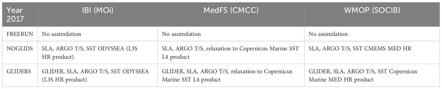
Table 2. Summary of the experiments and assimilated observations using the systems in Table 1.
2.3.1 Quality control and pre-processing before assimilation
Gliders go underwater along slightly inclined paths by changing their density (Davis et al., 2002). They provide very high-resolution observations in both space and time along their transect. The assimilation systems used at MedFS (OceanVar) and MedBFM (3DVarBIO) assumes a horizontal correlation length scale about 10-20 km, while the WMOP data assimilation system uses an EnOI scheme in which correlations are calculated from an ensemble of model realisations, with an additional localization radius of 200 km. Given the high-spatiotemporal resolution of gliders observations, their errors cannot be considered as independent from each other. Moreover, large differences in the resolution introduces a representation error in the observation error covariance matrix, R, in addition to the measurement error which is the instrumental accuracy. However, assimilation systems in use assume uncorrelated errors in observations, i.e., diagonal R, for the technical difficulties both in estimating off-diagonal terms of R and inverting it in the assimilation algorithms. The challenge of high-resolution observations is tackled in the atmospheric community (Janjić et al., 2017), later adopted also by the oceanic community, through the covariance inflation and observation pre-processing.
Specifically for the glider observations, past experiences suggest the following approaches, alone or combined, before the assimilation step:
Pre-processing to handle horizontal correlations in glider observations:
● Sub-sampling: Removing profiles in the inference radius of the observation position.
● Superobing: Averaging profiles falling into the same area to reduce the density of assimilated measurements.
Pre-processing to handle vertical correlations in glider observations:
● Binning in vertical grid levels.
● Discarding observations with large variance in vertical levels.
● Estimating representativity error from observation variance in vertical levels.
Other treatments of profiles may include:
● Discarding profiles with vertical gaps larger than a certain threshold between two measurements.
● Discarding profiles with a low number of measurements.
The optimal pre-processing of glider observations strongly depends on the model used, the type of assimilation scheme, the temporal window or the kind of observational errors considered. Here, we will consider the observation errors uncorrelated for the technical and computational reasons discussed above. Given the differences between the analysis and forecasting systems, and the fact that this optimal pre-processing approach is not unique, we decided not to follow the same strategy. Instead, each system employs its own pre-processing that minimises the errors in the analysis the most. Nevertheless, there is a need for a dedicated study for assessing the impact of different subsampling strategies which is out of the scope of this work.
For the IBI system, all ascending glider observations are used but they are interpolated vertically onto the model levels as it is also done for the other in-situ observations assimilated in the system. This approach allows to adapt the number of points in the vertical to the model resolution and avoid the assimilation of correlated observations.
In MedFS, several strategies are tested to assimilate glider observations. These include choosing all ascending and descending profiles if they sample the first 10 m of the water column to avoid constraining the surface with the deep observations. Another approach was to vertically subsample all ascending profiles on the model layers to avoid the correlations in the assimilated observations. Finally, the approach we use in this study is to select one profile from each dive, with the preference of the ascending profile when it exists, and without applying any vertical subsampling (Aydoğdu et al., 2023). This choice is done partially considering an increased observation error to the gliders to compensate for the dense observations. Moreover, we do not see a major increase in the computational cost in the minimisation of the cost function.
WMOP was already successfully used to assimilate glider measurements, as illustrated in Hernandez-Lasheras and Mourre (2018) where observations from up to eight glider vehicles were assimilated simultaneously. Glider profiles are considered as vertical in the present system (Copernicus Marine Service Level 2 product). Superobbing is applied along the vertical. For each profile, observations are binned in each vertical model grid cell. While the average over the cell provides the value to be assimilated, the variance is used to determine the vertical representation error. The horizontal representation error variance is assumed to be (0.25)2°C2 and (0.05)2 for temperature and salinity measurements, respectively. The total representation error variance is the addition of horizontal and vertical components. The instrumentation error is (0.1)2°C2 and (0.01)2 for glider temperature and salinity measurements, respectively. The model updates after analysis is performed every 3 days. At each analysis, a 5-day centred time window around the analysis time is used to select the glider, Argo and satellite along-track altimeter observations to be assimilated. These are added to the satellite SST Level 4 observations of the day of analysis.
2.3.2 Validation datasets and metrics
We performed a validation and intercomparison of three systems, putting a special emphasis in their capacity to reproduce physical processes and features. We focus on the transport processes in the Ibiza channel and on the formation and development of an anticyclonic warm core eddy in the Balearic Sea. This eddy has been previously studied in Aguiar et al. (2022), where the authors demonstrated that while the main driver of this eddy were the strong mistral winds in the region, the northward freshwater inflows linked to the dynamics across the Ibiza Channel also had an impact on the intensity of the eddy. In this work we have analysed the differences and capacities of the three systems to reproduce both processes in the different data assimilation experiments. The eddy structure is assessed by comparison with satellite observations, while the transport in the Ibiza Channel from the model is compared to that computed from the endurance line glider profiles available during most part of the year (Figure 1).
Since the eddy is present both in Sea Surface Temperature (SST) and in Sea Level Anomaly (SLA) observations, we have quantified, between the months of August to December 2017, the mean error (BIAS), root mean square difference (RMSD) and correlation between the different model estimates and the L4 satellite products in the Balearic sea region, in an area spanning from 1.8°E to 4.2°E in longitudinal, and 40.0°N and 41.8°N in latitudinal directions. To this aim, we extracted daily mean surface fields of the three systems and interpolated them onto the same 1/50° regular grid. Satellite observations were interpolated to that same grid before computing comparison metrics. For altimetry, we used the Copernicus Marine Service SEALEVEL_EUR_PHY_L4_MY_008_068 product and compared the absolute dynamic topography with the modelled sea surface height. For SST, we used the Copernicus Marine Service SST_MED_SST_L4_NRT_OBSERVATIONS_010_004 product and compute the metrics between the satellite L4 foundation and the model’s temperature in the first model layer.
In the results section below, we only show the SST maps for December, when the eddy is more intensified. The monthly means of the correlation and centred root mean square difference (cRMSD) are shown for this month, that we consider to be the most significant and explanatory for the performance of the systems. For SST, we consider the cRMSD to be more representative of the model capacity to reproduce a certain feature, since it does not include bias and thus is more related to the shape of the structure.
Besides, we used an eddy tracker algorithm (Mason et al., 2014) to perform a further qualitative validation. Given a sea surface height (SSH) field, the algorithm computes the geostrophic velocities, and identifies the eddies present in the simulations based on the contour shapes and the SSH gradients, categorising them in cyclonic or anticyclonic. Afterwards, given these daily identified eddies, the algorithm makes the tracking of the eddy trajectories, given a set of parameters. In our case we consider eddies that persist a minimum of 15 days, allowing 3 consecutive days of missing detection. Additionally, the sea surface height fields are filtered using a high-pass Bessel filter with a wavelength of 400 km to eliminate the large scale and focus on the mesoscale structures.
In the Ibiza Channel, following the work of Heslop et al. (2012), for each of the 44 available transects of the gliders in the year 2017, the observed temperature and salinity profiles are interpolated on a regular grid of the channel. From these T and S profiles, the dynamic height and the resulting cross-channel geostrophic currents are computed. Geostrophic transports are then evaluated by multiplying the positive and negative currents by the corresponding section. This method was also applied by Barceló-Llull et al. (2019) in the Mallorca channel and used to validate the operational model in Juza et al. (2016). To evaluate the transport of different water masses, a criterion to detect Winter Intermediate Water (WIW) was applied using the code from Juza et al. (2019). Atlantic Waters and Levantine Intermediate Waters are deduced from this criterion. We applied the exact same method to the model data co-located on the observation location and time in order to make a fair comparison to observations transports.
3 Results
In this section, we present the results of the experiments described in section 2.3. Various metrics described in section 2.4.2 are employed to assess different experiments. Comparisons are limited to the overlapping region in the western Mediterranean Sea.
3.1 Skill assessment against glider observations
In Figure 2, we show the comparison of experiments, i.e., FREERUN, NOGLIDS and GLIDERS, in each system in terms of RMSD against temperature and salinity glider profiles. Note that this specific validation, for GLIDERS, cannot be seen as fully independent as it uses glider data. However, the validation is performed on the entire dataset for all systems, while only a part of these observations was assimilated due to the preprocessing applied in each system (see Section 2.1.3).
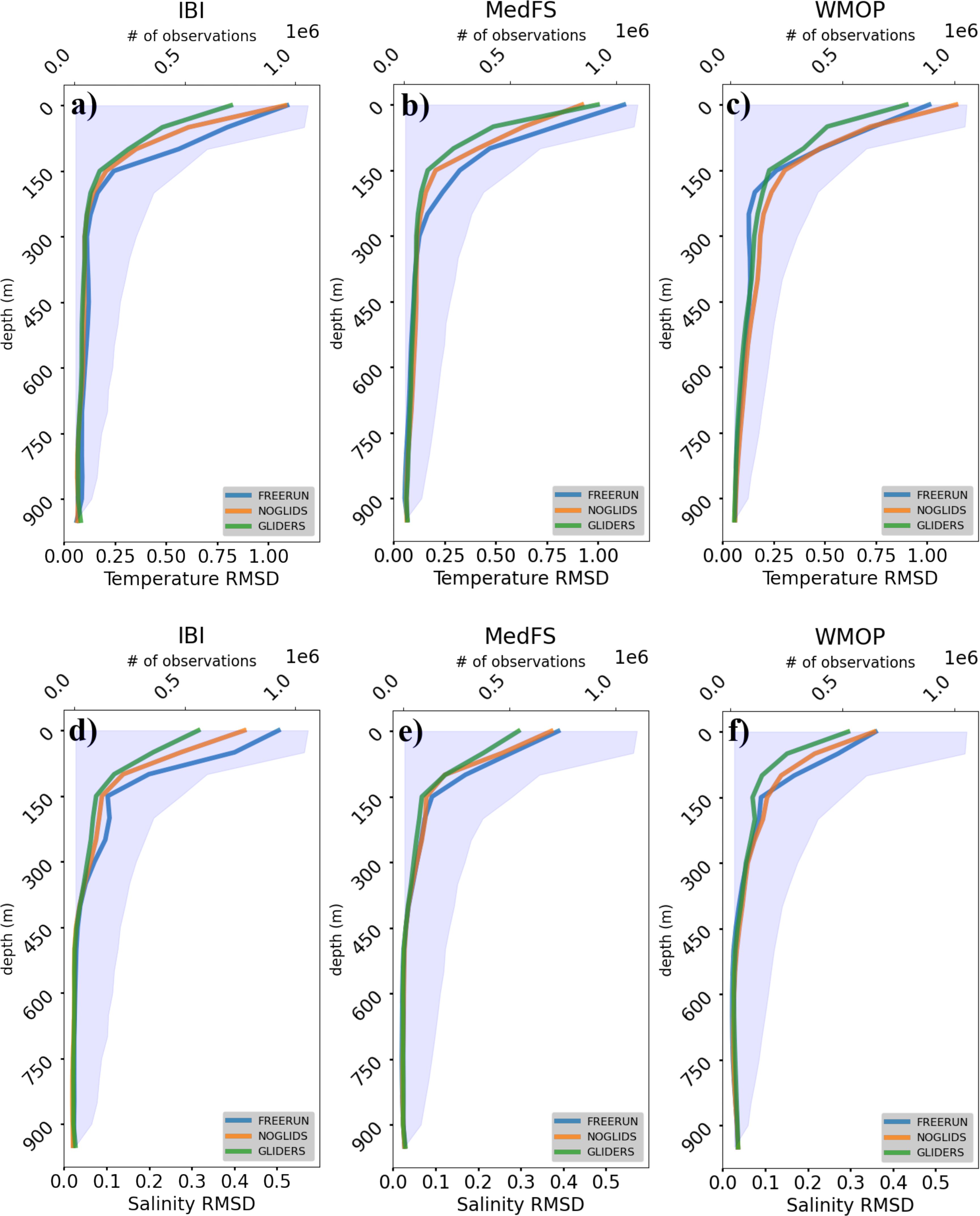
Figure 2. RMSD of temperature (A-C) and salinity (D-F) for IBI (A, D), MedFS (B, E) and WMOP (C, F) from FREERUN (blue), NOGLIDS (orange) and GLIDERS (green). The shaded area represents the distribution of observations through the water column.
The experiments in which glider observations (GLIDERS, in green) are ingested outperform experiments without gliders (NOGLIDS, in orange) and without assimilation (FREERUN, in blue) in each system for temperature (Figures 2A–C). The profiles of temperature RMSD in IBI (Figure 2A) shows an overall improvement up to 24% at surface layers with a slight degradation at depth maximum of -7% compared to NOGLIDS around 900 m. In MedFS, we note a small degradation of about 8% at the upper 0-50 m in the temperature, identified during the season with increased stratification (not shown). This may be due to improper observational errors that do not adequately represent the warming at the surface layers. Besides, glider assimilation improves the skill of the system (Figure 2B) up to 28% around 150 m against NOGLIDS. In WMOP, GLIDERS shows a significantly better skill with a 30% improvement close to the surface against NOGLIDS, which have slightly higher temperature mismatch with respect to the observations compared to the FREERUN (Figure 2C). Overall, glider data assimilation significantly improves the temperature estimates in all the systems.
For salinity, all systems (Figures 3D–F) benefit from glider assimilation demonstrating a better skill in all depths reaching up to 25%, 20% and 30% in the IBI, MedFS and WMOP, respectively. The errors are significantly reduced in GLIDERS compared to NOGLIDS and FREERUN till about 400 m. Below 800 m, in all systems, we note a slight error increase in GLIDERS. The degradation can reach 15% in IBI and 13% in WMOP while remaining 7% in the MedFS.

Figure 3. Monthly mean SST for IBI (A-C), MedFS (D-F) and WMOP (G-I) for FREERUN, NOGLIDS and GLIDERS. We also depict in (J) the mean SST from satellite L4 products of Copernicus Marine Service for comparison in red box. The blue box represents the area used to compute the error metrics shown in Figure 4.
3.2 Skill assessment against satellite observations
In this section, the focus is on the validation against sea surface temperature and height satellite observations. We do not assess the skill only statistically in this case but investigate the long-lived anti-cyclonic eddy developed between Barcelona and the Balearic Islands and studied in detail by Aguiar et al. (2022; see their ). The eddy formation started in August 2017 and lasted until the end of December as identified by satellite SST observations (Figure 3 last column). In December, all FREERUN experiments represented the eddy but were misplaced in IBI and WMOP and too large in MedFS. The intensity of the eddy seems to decrease with the assimilation in NOGLIDS in all the systems while the location becomes adjusted and better correlated with satellite SST. Eventually, with the integration of glider observations in GLIDERS, the shape and position compare better with the observations. All systems present a correlation over 0.9 for GLIDERS, significantly improving their results with respect to NOGLIDS (Figure 4). Besides, the ingestion of glider observations leads to a reduction of the cRMSD in the MedFS and WMOP systems, around 25% and 36% respectively, while IBI does not show a significant impact. The IBI system is the only one in which the assimilation of glider observations doesn’t have a marked impact, possible due to the good performance already obtained with the FREERUN, with a correlation above 0.88 and the lowest cRMSD among all simulations. While the SST correlation is still slightly improved, the RMSD in the area is identical between GLIDERS compared to NOGLIDERS. A similar conclusion can be drawn by tracking the location of the eddies in the region compared to the altimeter-based observations. In Figure 5, we show the trajectory of the eddy estimated from the altimeter in the red box on the rightmost panel and different experiments from each system between August and December. In the FREERUN, none of the systems correctly captures the eddy position during its entire evolution. MedFS captures the trajectory well but with a displacement of the centre of eddy tens of km’s, while IBI represents the eddy during the last part of November and December but slightly displaced southwards, with respect to the altimetry. The assimilation in NOGLIDS helps all systems to better locate the eddy. However, it presents difficulties to track it during the entire period. The algorithm used shows different tracks, as the eddy in these data assimilative runs may be abruptly changing position and shape or being replaced by another eddy, and thus the algorithm does not follow a continuous trajectory. MedFS is now accurate also for the location but with a shape that is a bit degraded. IBI and WMOP get closer to the observed trajectory compared to the FREERUN. In GLIDERS, WMOP has a better adjustment of the trajectory compared to NOGLIDS. In MedFS, the initial and final position of the eddy are also represented more accurately.
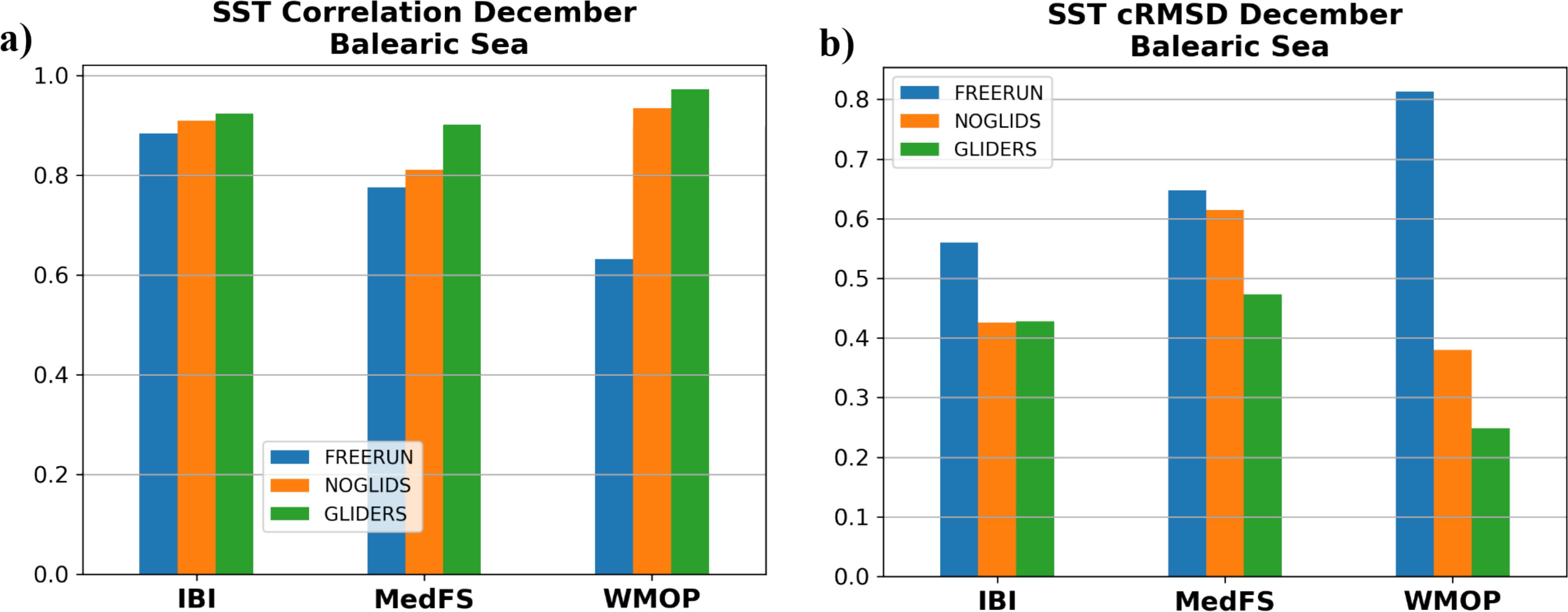
Figure 4. (A) Correlation and (B) cRMSD of SST for FREERUN (blue), NOGLIDS (orange) and GLIDERS (green) for each system computed over the blue box illustrated in Figure 3.
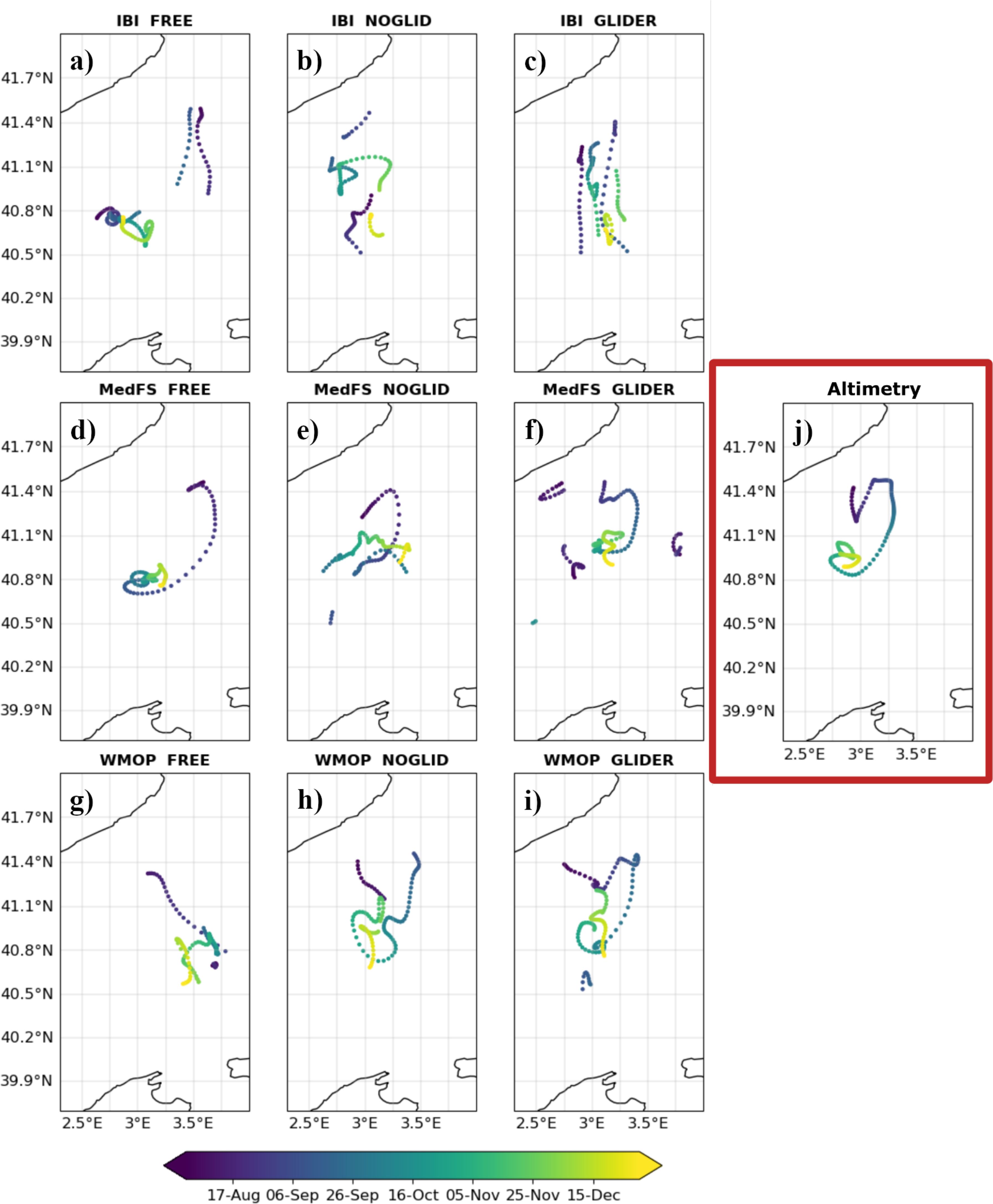
Figure 5. Trajectories of anticyclonic eddies tracked in the Balearic Sea from August to December 2017, with 15 or more days of life cycle estimated for IBI (A-C), MedFS (D-F) and WMOP (G-I) for FREERUN (left), NOGLIDS (center) and GLIDERS (right) columns of the 3x3 panels. (J) The trajectory estimated from the altimeter is depicted.
Overall, considering the different metrics, the assimilation of gliders is found to help improve the representation of this long-living mesoscale structure.
3.3 Transport through the Ibiza channel
We now turn our attention to the dynamical impacts in the Ibiza channel. In Figure 6, we show the geostrophic velocities in the channel calculated for different seasons. In winter, observations show that southward velocities dominate the flow in the channel above 200 m with a northward flow confined around 1°E. In all the systems, this northward flow occupies a larger section through the channel in NOGLIDS which is constrained better and localised in GLIDERS. The southward velocities in the western section are overestimated in all the systems in NOGLIDS and readjusted and improved in GLIDERS compared to observed velocities. The flow observed below 400 m, mostly northward, is correctly represented in each system. The southward flow which appears in NOGLIDS in WMOP between 400-600m around 0.7°E is accurately adjusted in GLIDERS. The RMSD decreases in all systems with the assimilation of glider observations, up to 2.5 cm/s. In April-June, northward velocities strengthen and spread westwards, which is well represented in IBI in both runs and overestimated in the other two systems in GLIDERS. MedFS improves in GLIDERS while missing the subsurface southward flow in the western section around 0.4°E which is well captured by WMOP and IBI. In July and September, surface flow is divided in two southward and two northward branches in a dipolar structure. The western and eastern sections are dominated by strong southward and northward velocities respectively, neighboured by an opposite flow. This structure is well captured only in the IBI system after the assimilation of gliders with an RMSD of 2.04 cm/s. There is a degradation in the MedFS in this period with an increase of RMSD about 1 cm/s while WMOP improves by about 1.2 cm/s. Finally, between October and December geostrophic velocities are mostly northwards. They are well-captured by IBI in NOGLIDS and GLIDERS and improved in WMOP in GLIDERS. In MedFS, assimilation of glider observations strengthens the southward velocities and degrades the estimates.
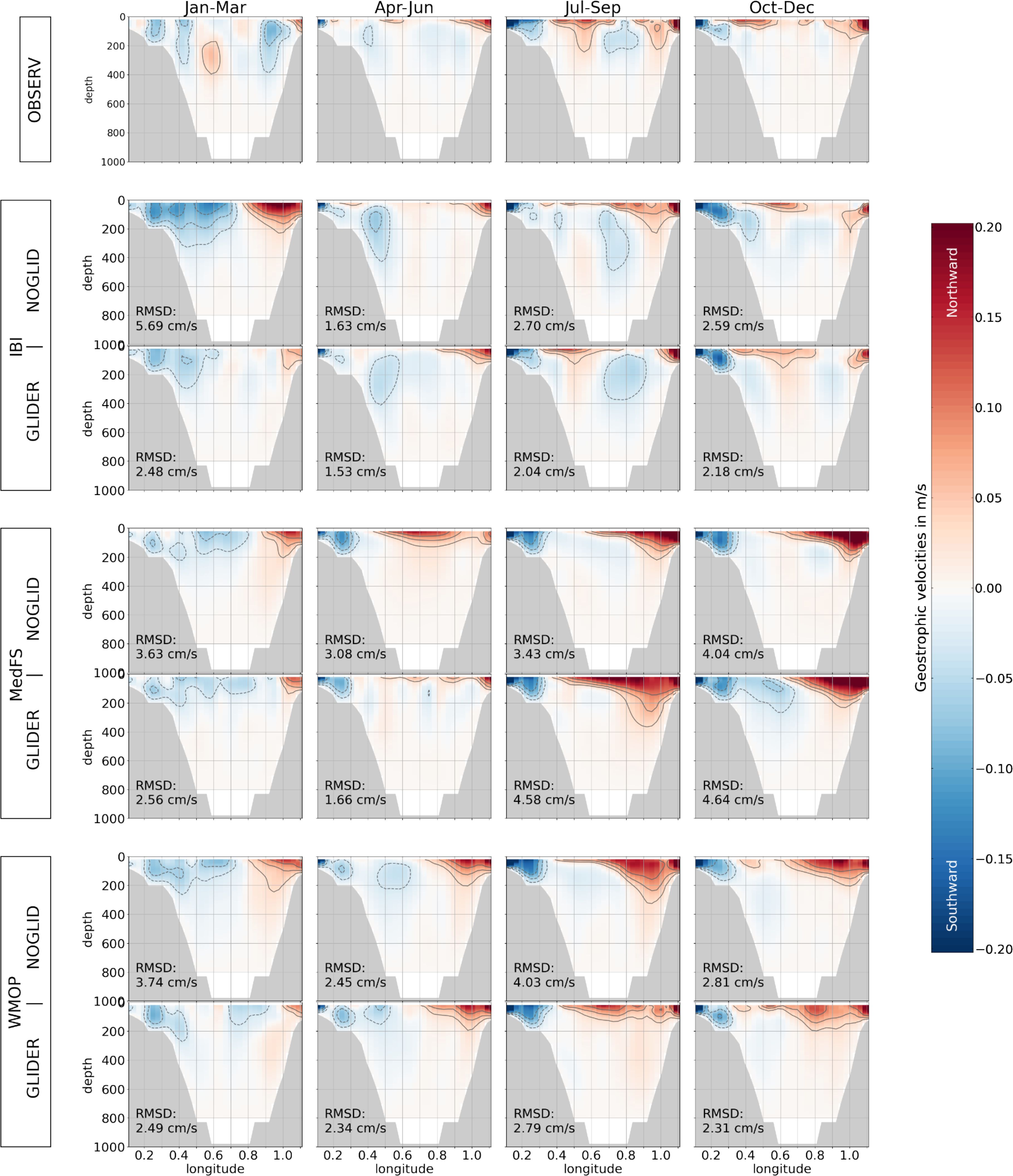
Figure 6. Section of geostrophic velocities through the Ibiza channel (see Figure 1). In the first row, the estimates from the glider observations are shown for Jan-Mar, Apr-Jun, Jul-Sep and Oct-Dec periods from left to right, respectively. The second and third rows show the same periods for the IBI NOGLIDS and GLIDERS experiments, respectively. The fourth and fifth rows show the same periods for the MedFS NOGLIDS and GLIDERS experiments, respectively. The last two rows depict the same periods for the WMOP NOGLIDS and GLIDERS experiments. The RMSD of each experiment for each system is shown in each panel.
In the Western Mediterranean Sea, several water masses can be identified: the surface Atlantic Waters (AW) coming from the Gibraltar Strait and getting saltier as it propagates around the basin, below them is the Levantine Intermediate Waters formed in the salty Eastern Mediterranean Sea that represent a maximum of salinity and the Western Mediterranean Deep Water (WMDW) at the bottom, created by the deep convection in the Gulf of Lion. The last typical water mass in the region is the WIW that are also formed in winter in the Northern part of the Western Mediterranean Sea under less strong conditions, characterised by a minimum of temperature and situated above the LIW.
The focus of the previous figure was on the Atlantic Waters in the upper part of the water column as this is the strongest transport in the channel and instead Figure 7 depicts the monthly time series of northward and southward transport of the intermediate water mass WIW through the Ibiza Channel. In the observations (in black line on all three panels), we measure strong transport northward and even stronger southward that gradually decreases until reaching zero at the end of the year. In IBI and MedFS, FREERUN does not have a transport of WIW as none were detected in the sections corresponding to the glider missions. WMOP has some WIW being advected southward in spring but with an underestimated total transport. In IBI, NOGLIDS represents the transport of WIW in both directions at the beginning of the year and this gets better when glider observations are included with a reduction of the RMSD (0.01 Sv improvement in northward transport) but the transport is still lower than observed. The MedFS run with assimilation of datasets other than gliders does not improve the transport of WIW but the inclusion of gliders shows a clear improvement of the transport in both directions with values below but still comparable to the observed transport and a reduced RMSD (0.02 Sv and 0.07 Sv improvement in northward and southward transports). In WMOP, NOGLIDS degrades the transport of WIW with an increased transport in the second part of the year. The assimilation of glider observations corrects this behaviour and the evolution of WIW transports gets closer to the observed data, although with some underestimation in both directions (0.01 Sv and 0.05 Sv improvement in RMSD of northward and southward transport, respectively).
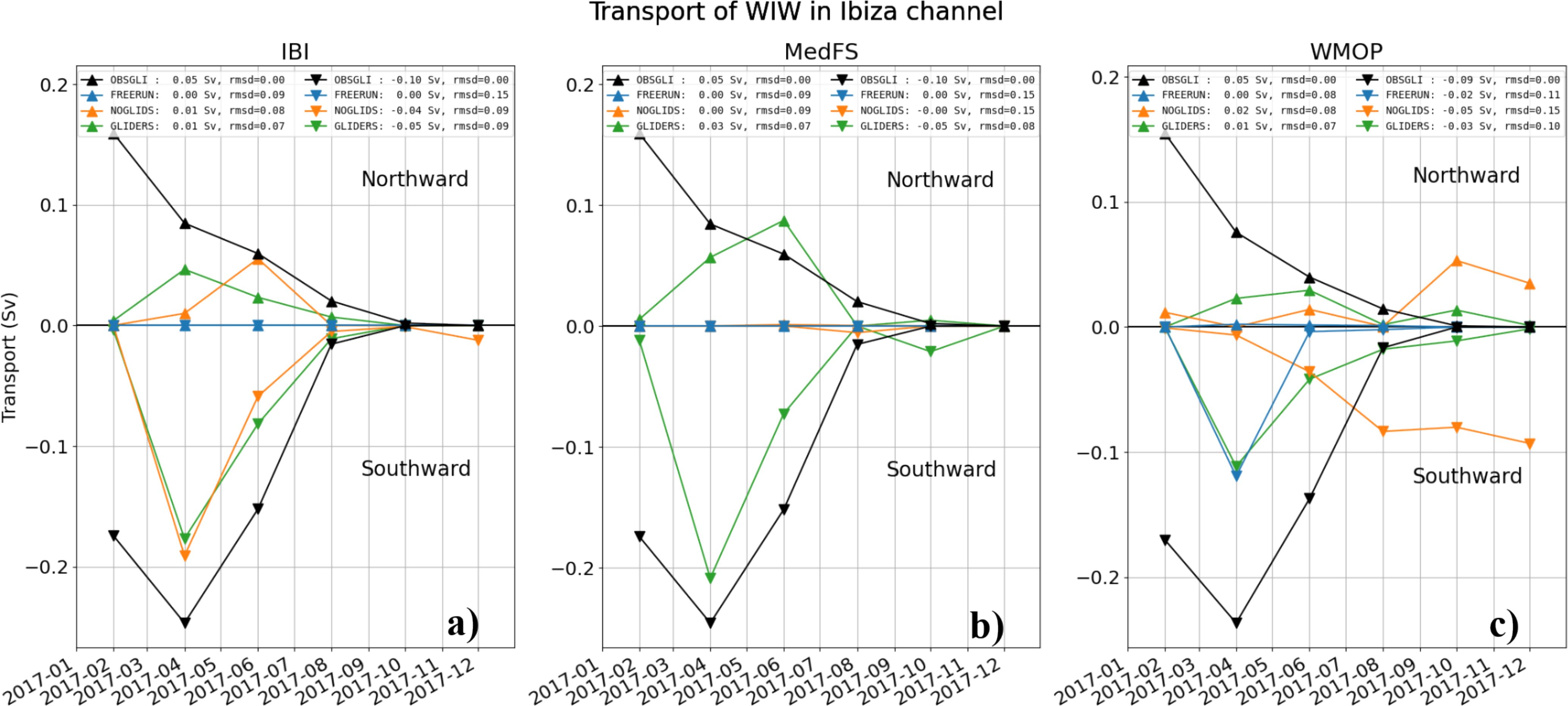
Figure 7. Northward and southward monthly transport through the Ibiza channel for (A) IBI, (B) MedFS and (C) WMOP from observations (black), FREERUN (blue), NOGLIDS (orange) and GLIDERS (green).
In summary, the representation of WIW transport through the Ibiza channel and its evolution throughout the year is found to be positively affected by glider data assimilation in all three systems.
3.4 Impact on MedBFM analysis estimates
We now consider the impact of using these data-assimilative simulations to force a biogeochemical model. These results exemplify how the assimilation of temperature and salinity from gliders can have a positive cascading effect also on biogeochemical variable patterns. Indeed, while the surface chlorophyll is generally overestimated by the biogeochemical model with respect to satellite data during the transition from low-surface value (November) to the autumn bloom (December, Figure 8), it is interesting to note how glider-corrected ocean dynamics produced a positive impact on specific biogeochemical dynamics and improved the quality of surface chlorophyll spatial patterns in the area north of the Balearic Islands. In particular, the anticyclonic eddy (dashed boxin Figure 8) is weakly simulated by NOGLIDS (Figure 3) and surface chlorophyll maps (Figures 8B, E) only partly show the round-shape low values visible in the satellite map of December. When gliders are assimilated, ocean dynamics simulated a more intense activity of the eddy with enhanced vertical mixing in its core (not shown). Consequently, while the rest of the basin underwent an increase of surface chlorophyll values due to the autumn bloom, specific dynamics (i.e., an excess of dilution due to enhanced vertical mixing) occurred in the core of the eddy increasing the fidelity of the simulated pattern (Figure 8F) with the satellite one (Figure 8D). Spatial correlation computed within the inner box improves from 0.47 to 0.57 in the NOGLIDS and GLIDERS simulations and modelled values of GLIDERS become closer to satellite observations with a 25% decrease of RMSD (Table 3).

Figure 8. Monthly maps of surface chlorophyll (mg chla/m3) in the north Balearic Sea for the satellite (A, B) and the simulation without (B, E) and with (C, F) glider assimilation. Inner black dashed boxes in the December maps indicate the area over which the statistics is computed.
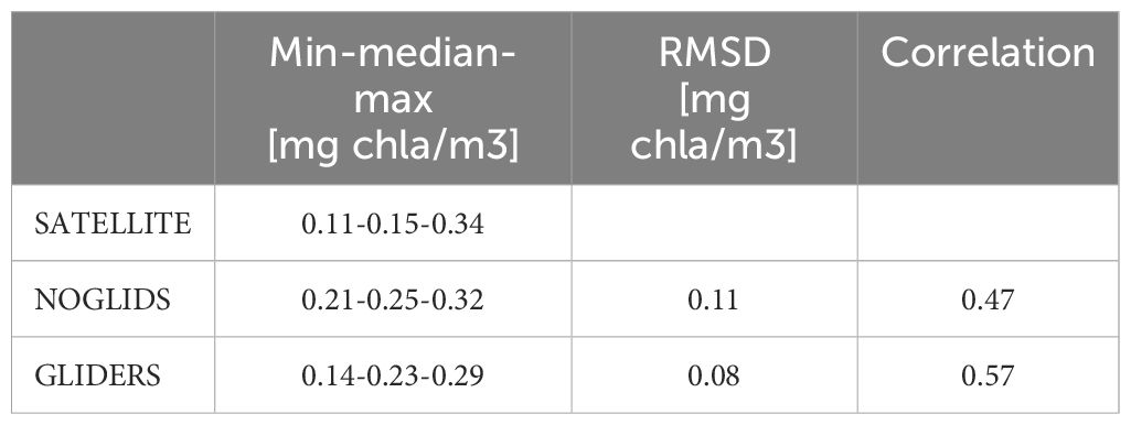
Table 3. Statistics of chlorophyll computed for December in the areas delimited by the dashed box in Figure 8.
Figure 9 clarifies the changes on the vertical dynamics produced by the assimilation of gliders. Following the summer stratified conditions (November), enhanced vertical mixing initiated a surface chlorophyll bloom over the whole area (December). However, the glider assimilation produced an extra mixing in the core of the eddy that made the dilution due to vertical mixing exceeding the phytoplankton growth capability and generating the pattern with minimum values at the centre of the eddy (Figure 9D).
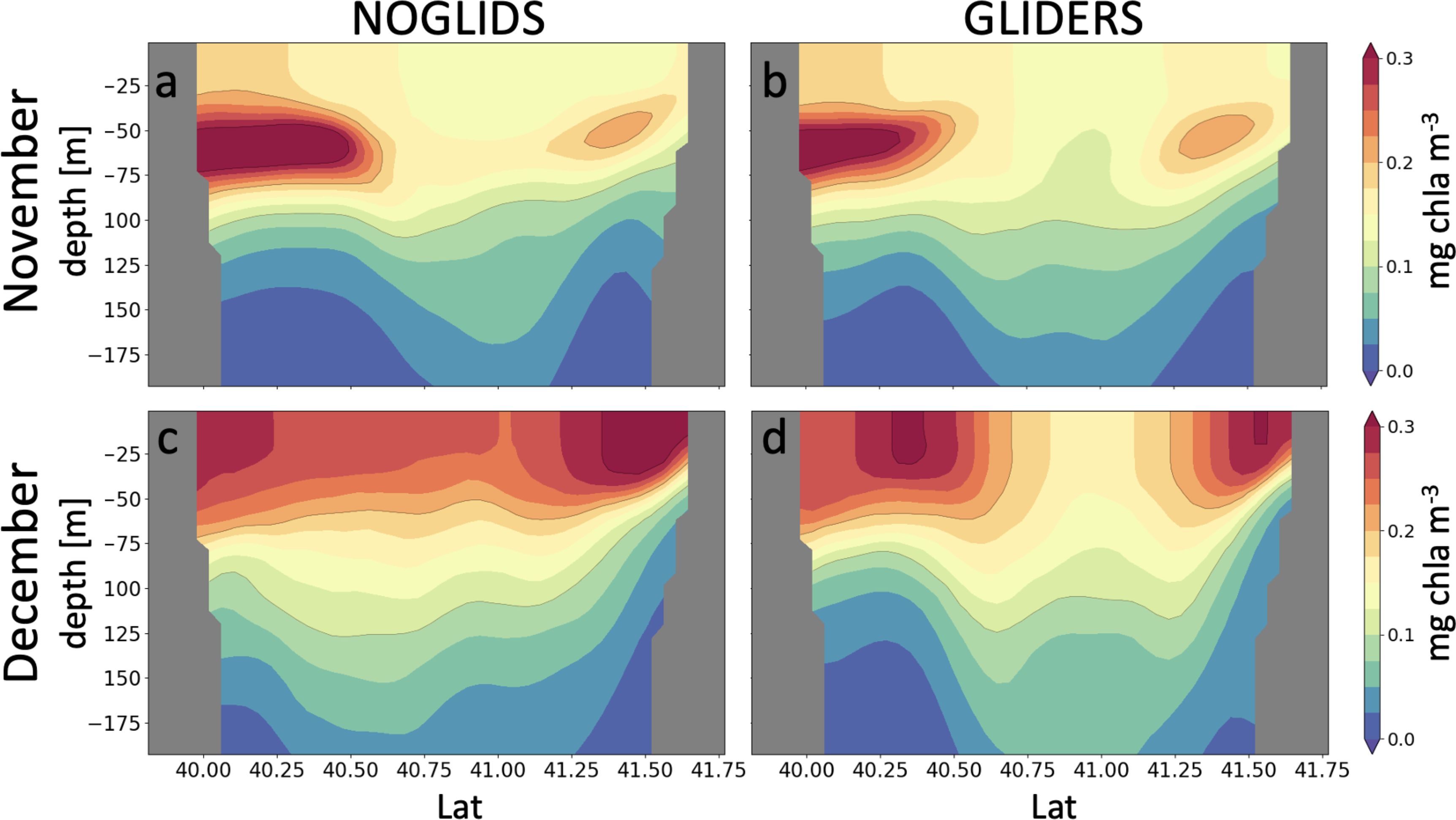
Figure 9. Vertical section of chlorophyll monthly averages at Lon=3° in the northern Balearic Sea for the runs without (A, C) and with (B, D) glider assimilation.
4 Discussion and conclusions
In this study, we presented a set of coordinated experiments to assess the impact of glider observations on three distinct ocean analysis and forecasting systems overlapping in the Western Mediterranean Sea - IBI, MedFS and WMOP - using various metrics and diagnostics. Moreover, a BGC analysis system, MedBFM, is employed to understand how the corrections through temperature and salinity glider measurements can impact the biogeochemical state of the Mediterranean Sea in a forced/offline coupled configuration.
The aim of this study is to assess the impact of glider observations and investigate the methodologies to ingest them while developing metrics and diagnostics to intercompare completely different systems. The same set of experiments are performed using each system i) without assimilation, ii) with assimilation but without gliders and finally iii) with gliders. A set of year-long experiments for the impact assessment of gliders with three different analysis systems makes this study unique to our knowledge.
As it is shown, glider assimilation has an overall positive impact on the state estimation of the Western Mediterranean no matter what system is employed or how the preprocessing of the observations are performed. The experiments with glider assimilation usually show a better skill compared to the other two experiments in terms of SST and temperature and salinity profiles RMSD. A few cases were identified in which the model performance could be improved with a better tuning of the observation errors. However, the overall statistical skill is better in the experiments with glider assimilation. This is also true when considering the representation of the specific long-lived eddy event in the Balearic Sea and the transport of water masses in the Ibiza Channel. Finally, glider data assimilation is also found to have positive impacts on the biogeochemical variables represented by a model forced by the different physical simulations.
In the case of the Balearic eddy, both the SST and altimeter observations confirm that gliders help improve the location and intensity of the eddy. We highlight here that in the experiment period there is no glider deployed in the eddy area. The impact probably comes from the closest glider data in the Ibiza Channel to the south, and from the Gulf of Lion to Menorca Island to the east. This shows the importance of monitoring the ocean with a glider network to better estimate mesoscale features and suggests the importance of correcting the circulation patterns in regions even far away from the target areas. Aguiar et al. (2022) found evidence that the important factors for the generation and intensification of the eddy were the intense north-westerly wind events and the strong thermal front formed between the Gulf of Lion and the Balearic Sea at the end of the summer. Northward inflows of relatively fresh water through the Ibiza Channel were also demonstrated to have some impact. The better representation of the thermohaline properties over the basin is probably responsible for the better representation of the eddy location and intensity in the simulations with glider data assimilation in this study.
The geostrophic velocities and associated transports of WIW through the Ibiza Channel have been investigated in the different systems, showing the benefit of the observations collected along the corresponding endurance line to improve the flow characteristics especially close to the surface. The transport of WIW is improved in all three systems when the glider observations are assimilated.
Finally, we showed that glider assimilation helps to improve the biogeochemical estimates by modifying water masses and improving mesoscale structures through their role on the mixing dynamics. The results are encouraging to go a step further and assimilate BGC glider observations in the coupled configurations.
We conclude that all of the systems used in this study benefit from glider observations when assimilated in their standard configuration. The improvements are of the same order of magnitude in all three systems, yet with slightly different behaviours according to the evaluation metric under consideration. This provides both robustness and uncertainty estimates to the glider data impact assessment presented in this study. Besides the demonstration of the value of glider observations for Western Mediterranean forecasting systems, this intercomparison exercise also allowed us to highlight relative strengths and possible deficiencies of the different systems, which is useful to identify future ways of improvement. Overall, considering the positive impact on forecasting systems, we recommend maintaining the current glider endurance lines and possibly enhancing the glider network by further deployments in the Mediterranean and European Seas.
Data availability statement
The original contributions presented in the study are included in the article/supplementary material. Further inquiries can be directed to the corresponding author/s.
Author contributions
AA: Writing – original draft, Writing – review & editing. RE: Writing – original draft, Writing – review & editing. JH: Writing – original draft, Writing – review & editing. CA: Writing – original draft, Writing – review & editing. JP: Writing – original draft, Writing – review & editing. NZ: Writing – original draft, Writing – review & editing. GC: Writing – original draft, Writing – review & editing. ER: Writing – original draft, Writing – review & editing. BM: Writing – original draft, Writing – review & editing.
Funding
The author(s) declare that financial support was received for the research, authorship, and/or publication of this article. This study is conducted within the EuroSea project, which has received funding from the European Union’s Horizon 2020 research and innovation programme under grant agreement No 862626.
Acknowledgments
The glider missions were led by several European institutes, universities, and organisations (SOCIB, IMEDEA, CNR, University of Parthenope, Ifremer, ENSTA, INSU, CMRE and INSU). The success of the glider operations is mainly due to the dedication, collaboration and commitment of the different research institutes, universities and organisations around Europe that made available their observations in Copernicus Marine Service in-situ TAC. Also, thanks goes to Victor Turpin and Daniel Hayes for helpful discussions during the study. In addition, JHL, NZ and BM are grateful to AEMET for providing the HIRLAM model fields used in the WMOP forecasting system. AA and JP thank Alessandro Grandi for assisting the data preparation. Finally, we acknowledge Copernicus Marine Service for providing the remote sensing observations of SST, SLA and CHL-a. In addition, special thanks go to Miguel Charcos, Albert Miralles, and Manu Rubio for their support during the SOCIB glider missions.
Conflict of interest
The authors declare that the research was conducted in the absence of any commercial or financial relationships that could be construed as a potential conflict of interest.
The author(s) declared that they were an editorial board member of Frontiers, at the time of submission. This had no impact on the peer review process and the final decision.
Publisher’s note
All claims expressed in this article are solely those of the authors and do not necessarily represent those of their affiliated organizations, or those of the publisher, the editors and the reviewers. Any product that may be evaluated in this article, or claim that may be made by its manufacturer, is not guaranteed or endorsed by the publisher.
Footnotes
- ^ For an overview of operational ocean forecasting systems represented under OceanPredict programme see https://oceanpredict.org/science/operational-ocean-forecasting-systems/ocean-products-services/.
- ^ The workshop report can be accessed here. Last accessed 6 May 2024.
References
Aguiar E., Mourre B., Alvera-Azcárate A., Pascual A., Mason E., Tintoré J. (2022). Strong long-lived anticyclonic mesoscale eddies in the Balearic Sea: Formation, intensification, and thermal impact. J. Geophysical Research: Oceans 127, e2021JC017589. doi: 10.1029/2021JC017589
Aydoğdu A., Hernandez-Lasheras J., Amadio C., Mourre B., Cossarini G., Pistola J. (2023). “Design of the glider assimilation experiments - revised edition,” in EuroSea Deliverable, vol. D4.2. (OceanRep Geomar: EuroSea), 18 pp. doi: 10.3289/eurosea_d4.2_v2
Aydoğdu A., Pinardi N., Özsoy E., Danabasoglu G., Gürses Ö., Karspeck A. (2018). Circulation of the Turkish Straits System under interannual atmospheric forcing. Ocean Sci. 14, 999–1019. doi: 10.5194/os-14-999-2018
Balmaseda M. A., Hernandez F., Storto A., Palmer M. D., Alves O., Shi L., et al. (2015). The ocean reanalyses intercomparison project (ORA-IP). J. Operational Oceanography 8, s80–s97. doi: 10.1080/1755876X.2015.1022329
Barceló-Llull B., Pascual A., Ruiz S., Escudier R., Torner M., Tintoré J. (2019). Temporal and spatial hydrodynamic variability in the Mallorca channel (western Mediterranean Sea) from 8 years of underwater glider data. J. Geophysical Research: Oceans 124, 2769–2786. doi: 10.1029/2018JC014636
Benveniste J., Cazenave A., Vignudelli S., Fenoglio-Marc L., Shah R., Almar R., et al. (2019). Requirements for a coastal hazards observing system. Front. Mar. Sci. 6. doi: 10.3389/fmars.2019.00348
Bonaduce A., Cipollone A., Johannessen J. A., Staneva J., Raj R. P., Aydogdu A. (2021). Ocean mesoscale variability: a case study on the Mediterranean Sea from a re-analysis perspective. Front. Earth Sci. 9, 724879. doi: 10.3389/feart.2021.724879
Bosse A., Testor P., Mortier L., Prieur L., Taillandier V., d’Ortenzio F., et al. (2015). Spreading of Levantine Intermediate Waters by submesoscale coherent vortices in the northwestern Mediterranean Sea as observed with gliders. J. Geophysical Research: Oceans 120, 1599–1622. doi: 10.1002/2014JC010263
Brodeau L., Barnier B., Gulev S. K., Woods C. (2017). Climatologically significant effects of some approximations in the bulk parameterizations of turbulent air-sea fluxes. J. Phys. Oceanogr. 47, 5–28. doi: 10.1175/JPO-D-16-0169.1
Clementi E., Aydogdu A., Goglio A. C., Pistoia J., Escudier R., Drudi M., et al. (2021). Mediterranean Sea Physical Analysis and Forecast (CMEMS MED-Currents, EAS6 system) (Version 1) set [Data set]. (Copernicus: Copernicus Monitoring Environment Marine Service (CMEMS).
Coppini G., Clementi E., Cossarini G., Salon S., Korres G., Ravdas M., et al. (2023). The Mediterranean forecasting system - part 1: evolution and performance. Ocean Sci. 19, 1483–1516. doi: 10.5194/os-19-1483-2023
Coppola L., Raimbault P., Mortier L., Testor P. (2019). “Monitoring the environment in the northwestern Mediterranean Sea,” in Eos, Transactions American Geophysical Union (EOS: American Geophysical Union (AGU), 100.
Cossarini G., Feudale L., Teruzzi A., Bolzon G., Coidessa G., Solidoro C., et al. (2021). High-resolution reanalysis of the Mediterranean Sea biogeochemistry, (1999–2019). Front. Mar. Sci. 8, 741486. doi: 10.3389/fmars.2021.741486
Cotroneo Y., Aulicino G., Ruiz S., Pascual A., Budillon G., Fusco G., et al. (2016). Glider and satellite high resolution monitoring of a mesoscale eddy in the Algerian basin: Effects on the mixed layer depth and biochemistry. J. Mar. Syst. 162, 73–88. doi: 10.1016/j.jmarsys.2015.12.004
Cotroneo Y., Aulicino G., Ruiz S., Sánchez Román A., Torner Tomàs M., Pascual A., et al. (2019). Glider data collected during the Algerian Basin Circulation Unmanned Survey. Earth Syst. Sci. Data 11, 147–161. doi: 10.5194/essd-11-147-2019
Davis R., Eriksen C., Jones C. (2002). “Autonomous buoyancy-driven underwater gliders,” in The technology and applications of autonomous underwater vehicles, ed. Griffiths G. (London: Taylor and Francis), 37–58. doi: 10.1201/9780203522301.ch3
Dobricic S., Pinardi N. (2008). An oceanographic three-dimensional variational data assimilation scheme. Ocean Model. 22, 89–105. doi: 10.1016/j.ocemod.2008.01.004
Dobricic S., Pinardi N., Testor P., Send U. (2010). Impact of data assimilation of glider observations in the Ionian Sea (Eastern Mediterranean). Dynamics Atmospheres Oceans 50, 78–92. doi: 10.1016/j.dynatmoce.2010.01.001
Duguid Z., Camilli R. (2021). Improving resource management for unattended observation of the marginal ice zone using autonomous underwater gliders. Front. Robot. AI 7. doi: 10.3389/frobt.2020.579256
Escudier R., Renault L., Pascual A., Brasseur P., Chelton D., Beuvier J. (2016). Eddy properties in the Western Mediterranean Sea from satellite altimetry and a numerical simulation. J. Geophys. Res. Oceans 121, 3990–4006. doi: 10.1002/2015JC011371
Ford D. A., Grossberg S., Rinaldi G., Menon P. P., Palmer M. R., Skákala J., et al. (2022). A solution for autonomous, adaptive monitoring of coastal ocean ecosystems: Integrating ocean robots and operational forecasts. Front. Mar. Sci. 9. doi: 10.3389/fmars.2022.1067174
Gangopadhyay A., Schmidt A., Agel L., Schofield O., Clark J. (2013). Multiscale forecasting in the western North Atlantic: Sensitivity of model forecast skill to glider data assimilation. Continental Shelf Res. 63, S159–S176. doi: 10.1016/j.csr.2012.09.013
Garcia-Jove M., Mourre B., Zarokanellos N. D., Lermusiaux P. F. J., Rudnick D. L., Tintoré J. (2022). Frontal dynamics in the Alboran Sea: 2. Processes for vertical velocities development. J. Geophysical Research: Oceans 127, e2021JC017428. doi: 10.1029/2021JC017428
Glenn S. M., Miles T. N., Seroka G. N., Xu Y., Forney R. K., Yu F., et al. (2016). Stratified coastal ocean interactions with tropical cyclones. Nat. Commun. 7, 10887. doi: 10.1038/ncomms10887
Griffies S. M., Danabasoglu G., Durack P. J., Adcroft A. J., Balaji V., Böning C. W., et al. (2016). OMIP contribution to CMIP6: experimental and diagnostic protocol for the physical component of the Ocean Model Intercomparison Project. Geosci. Model. Dev. 9, 3231–3296. doi: 10.5194/gmd-9-3231-2016
Halliwell G. R., Goni G. J., Mehari M. F., Kourafalou V. H., Baringer M., Atlas R. (2020). OSSE assessment of underwater glider arrays to improve ocean model initialization for tropical cyclone prediction. J. atmospheric oceanic Technol. 37, 467–487. doi: 10.1175/JTECH-D-18-0195.1
Hayes D. R., Dobricic S., Gildor H., Matsikaris A. (2019). Operational assimilation of glider temperature and salinity for an improved description of the Cyprus eddy. Deep Sea Res. Part II: Topical Stud. Oceanography 164, 41–53. doi: 10.1016/j.dsr2.2019.05.015
Hernandez F., Bertino L., Brassington G., Chassignet E., Cummings J., Davidson F., et al. (2009). Validation and intercomparison studies within GODAE. Oceanography 22, 128–143. doi: 10.5670/oceanog.2009.71
Hernández-Carrasco I., Orfila A. (2018). The role of an intense front on the connectivity of the western Mediterranean Sea: The cartagena-Tenes front. J. Geophysical Research: Oceans 123, 4398–4422. doi: 10.1029/2017JC013613
Hernandez-Lasheras J., Mourre B. (2018). Dense CTD survey versus glider fleet sampling: comparing data assimilation performance in a regional ocean model west of Sardinia. Ocean Sci. 14, 1069–1084. doi: 10.5194/os-14-1069-2018
Hernandez-Lasheras J., Mourre B., Orfila A., Santana A., Reyes E., Tintoré J. (2021). Evaluating high-frequency radar data assimilation impact in coastal ocean operational modelling. Ocean Sci. 17, 1157–1175. doi: 10.5194/os-17-1157-2021
Heslop E. E., Ruiz S., Allen J., López-Jurado J. L., Renault L., Tintoré J. (2012). Autonomous underwater gliders monitoring variability at “choke points” in our ocean system: A case study in the Western Mediterranean Sea. Geophysical Res. Lett. 39, L20604. doi: 10.1029/2012GL053717
Hristova H. G., Kessler W. S., McWilliams J. C., Molemaker M. J. (2014). Mesoscale variability and its seasonality in the Solomon and Coral Seas. J. Geophysical Research: Oceans 119, 4669–4687. doi: 10.1002/2013JC009741
Janjić T., Bormann N., Bocquet M., Carton J. A., Cohn S. E., Dance S. L., et al. (2017). On the representation error in data assimilation. Q J. R Meteorol Soc 144, 1257–1278. doi: 10.1002/qj.3130
Jones E. M., Baird M. E., Mongin M., Parslow J., Skerratt J., Lovell J., et al. (2016). Use of remote-sensing reflectance to constrain a data assimilating marine biogeochemical model of the Great Barrier Reef. Biogeosciences 13, 6441–6469. doi: 10.5194/bg-13-6441-2016
Juza M., Escudier R., Vargas-Yáñez M., Mourre B., Heslop E., Allen J., et al. (2019). Characterization of changes in Western Intermediate Water properties enabled by an innovative geometry-based detection approach. J. Mar. Syst. 191, 1–12. doi: 10.1016/j.jmarsys.2018.11.003
Juza M., Mourre B., Renault L., Gómara S., Sebastián K., Lora S., et al. (2016). SOCIB operational ocean forecasting system and multi-platform validation in the western Mediterranean Sea. J. Oper. Oceanogr. 9: sup1, s155–s166. doi: 10.1080/1755876X.2015.1117764
Kaufman D. E., Friedrichs M. A. M., Hemmings J. C. P., Smith J. W.O. (2018). Assimilating bio-optical glider data during a phytoplankton bloom in the southern Ross Sea. Biogeosciences 15, 73–90. doi: 10.5194/bg-15-73-2018
Kerry C., Roughan M., Powell B. (2018). Observation impact in a regional reanalysis of the East Australian Current System. J. Geophysical Research: Oceans 123, 7511–7528. doi: 10.1029/2017JC013685
Lee C. M., Rudnick D. L. (2018). “Underwater gliders,” in Observing the Oceans in Real Time. Eds. Venkatesan R., Tandon A., D’Asaro E., Atmanand M. (Springer Oceanography. Springer, Cham). doi: 10.1007/978-3-319-66493-4_7
Lellouche J. M., Greiner E., Le Galloudec O., Garric G., Regnier C., Drevillon M., et al. (2018). Recent updates to the CopernicusMarine Service global ocean monitoring and forecasting real-time 1/12 high-resolution system. Ocean Sci. 14, 1093–1126. doi: 10.5194/os-14-1093-2018
Lellouche J.-M., Le Galloudec O., Drévillon M., Régnier C., Greiner E., Garric G., et al. (2013). Evaluation of global monitoring and forecasting systems at Mercator Océan. Ocean Sci. 9, 57–81. doi: 10.5194/os-9-57-2013
Lermusiaux P. F. (2007). Adaptive modeling, adaptive data assimilation and adaptive sampling. Physica D: Nonlinear Phenomena 230, 172–196. doi: 10.1016/j.physd.2007.02.014
Liblik T., Karstensen J., Testor P., Alenius P., Hayes D., Ruiz S., et al. (2016). Potential for an underwater glider component as part of the Global Ocean Observing System. Methods Oceanography 17, 50–82. doi: 10.1016/j.mio.2016.05.001
Liu L., Mehra A., Kleist D., Vernieres G., Sluka T., Bhargava K., et al. (2023). Impact of assimilating satellite and glider observations on hurricane Isaias (2020) forecast using marine JEDI. Weather Forecasting 38, 1807–1826. doi: 10.1175/WAF-D-22-0014.1
Many G., Ulses C., Estournel C., Marsaleix P. (2021). Particulate organic carbon dynamics in the Gulf of Lion shelf (NW Mediterranean) using a coupled hydrodynamic–biogeochemical model. Biogeosciences 18, 5513–5538. doi: 10.5194/bg-18-5513-2021
Margirier F., Bosse A., Testor P., L’Heveder B., Mortier L., Smeed D. (2017). Characterization of convective plumes associated with oceanic deep convection in the northwestern Mediterranean from high-resolution in situ data collected by gliders. J. Geophysical Research: Oceans 122, 9814–9826. doi: 10.1002/2016JC012633
Margirier F., Testor P., Heslop E., Mallil K., Bosse A., Houpert L., et al. (2020). Abrupt warming and salinification of intermediate waters interplays with decline of deep convection in the Northwestern Mediterranean Sea. Sci. Rep. 10, 20923. doi: 10.1038/s41598-020-77859-5
Martin M. J., Remy E., Tranchant B., King R. R., Greiner E., Donlon C. (2020). Observation impact statement on satellite sea surface salinity data from two operational global ocean forecasting systems. J. Operational Oceanography 15, 87–103. doi: 10.1080/1755876X.2020.1771815
Mason E., Pascual A., McWilliams J. C. (2014). A new sea surface height–based code for oceanic mesoscale eddy tracking. J. Atmospheric Oceanic Technol. 31, 1181–1188. doi: 10.1175/JTECH-D-14-00019.1
Moltmann T., Turton J., Zhang H.-M., Nolan G., Gouldman C., Griesbauer L., et al. (2019). A global ocean observing system (GOOS), delivered through enhanced collaboration across regions, communities, and new technologies. Front. Mar. Sci. 6. doi: 10.3389/fmars.2019.00291
Mourre B., Aguiar E., Juza M., Hernandez-Lasheras J., Reyes E., Heslop E., et al. (2018). “Assessment of high-resolution regional ocean prediction systems using multi-platform observations: illustrations in the Western Mediterranean Sea,” in New Frontiers in Operational Oceanography. Eds. Chassignet E., Pascual A., Tintoré J., Verron J. (GODAE Ocean View: GODAE Ocean View), 663–694. doi: 10.17125/gov2018.ch24
Mourre B., Alvarez A. (2012). Benefit assessment of glider adaptive sampling in the Ligurian Sea. Deep Sea Res. Part I: Oceanographic Res. Papers 68, 68–78. doi: 10.1016/j.dsr.2012.05.010
Mourre B., Chiggiato J. (2014). A comparison of the performance of the 3-D super-ensemble and an ensemble Kalman filter for short-range regional ocean prediction. Tellus A: Dynamic Meteorology Oceanography 66, 21640. doi: 10.3402/tellusa.v66.21640
Mourre B., Clementi E., Coppini G., Coppola L., Korres G., Novellino A., et al. (2022). “Chapter 10 - Mediterranean observing and forecasting systems,” in Oceanography of the Mediterranean Sea - An Introductory Guide. Eds. Schroeder K., Chiggiato J. (Elsevier), 335–386, ISBN: ISBN 9780128236925. doi: 10.1016/B978-0-12-823692-5.00001-7
Özsoy E., Sofianos S., Gertman I., Mantziafou A., Aydoğdu A., Georgiou S., et al. (2014). “Deep-water variability and interbasin interactions in the eastern Mediterranean Sea,” in The Mediterranean Sea: Temporal Variability and Spatial Patterns, 85–112, John Wiley, Oxford, London.
Pan C., Yaremchuk M., Nechaev D., Ngodock H. (2011). Variational assimilation of glider data in Monterey Bay. J. Mar. Res. 69, 331–346. doi: 10.1357/002224011798765259
Pasmans I., Kurapov A. L., Barth J. A., Ignatov A., Kosro P. M., Shearman R. K. (2019). Why gliders appreciate good company: glider assimilation in the Oregon-Washington coastal ocean 4DVAR system with and without surface observations. J. Geophysical Research: Oceans 124, 750–772. doi: 10.1029/2018JC014230
Patmore R. D., Ferreira D., Marshall D. P., du Plessis M. D., Brearley J. A., Swart S. (2024). Evaluating existing ocean glider sampling strategies for submesoscale dynamics. J. Atmos. Oceanic Technol. 41, 647–663. doi: 10.1175/JTECH-D-23-0055.1
Pessini F., Borghini M., Chiggiato J., Schroeder K., Perilli A., Heslop E., et al. (2018). SMART” Sardinia – MAllorca Repeated Transect: first results from a new glider line in the western Mediterranean Sea. Geophysical Res. Abstracts 20. EGU2018-16655, EGU General Assembly 2018.
Pham D., Verron J., Roubaud M. (1998). A Singular Evolutive Extended Kalman filter for data assimilation in oceanography. J. Mar. Syst. 16, 323–340. doi: 10.1016/s0924-7963(97)00109-7
Pinardi N., Zavatarelli M., Adani M., Coppini G., Fratianni C., Oddo P., et al. (2015). Mediterranean Sea large-scale low-frequency ocean variability and water mass formation rates from 1987 to 2007: A retrospective analysis. Prog. Oceanography 132, 318–332. doi: 10.1016/j.pocean.2013.11.003
Rudnick D. L. (2016). Ocean research enabled by underwater gliders. Annu. Rev. Mar. Sci. 8, 519–541. doi: 10.1146/annurev-marine-122414-033913
Rudnick D. L., Zaba K. D., Todd R. E., Davis R. E. (2017). A climatology of the California Current System from a network of underwater gliders. Prog. Oceanography 154, 64–106. doi: 10.1016/j.pocean.2017.03.002
Salon S., Cossarini G., Bolzon G., Feudale L., Lazzari P., Teruzzi A., et al. (2019). Novel metrics based on Biogeochemical Argo data to improve the model uncertainty evaluation of the CMEMS Mediterranean marine ecosystem forecasts. Ocean Sci. 15, 997–1022. doi: 10.5194/os-15-997-2019
Sanchez-Roman A., Jorda G., Sannino G., Gomis D. (2018). Modelling study of transformations of the exchange flows along the Strait of Gibraltar. Ocean Sci. 14, 1547–1566. doi: 10.5194/os-14-1547-2018
Sannino G., Bargagli A., Artale V. (2004). Numerical modeling of the semidiurnal tidal exchange through the Strait of Gibraltar. J. Geophys. Res. 109, C05011. doi: 10.1029/2003JC002057
Shchepetkin A. F., McWilliams J. C. (2004). The regional ocean modelling system (ROMS): a split explicit, free-surface, topography-following-coordinate oceanic model. Ocean Model. 9, 347–404. doi: 10.1016/j.ocemod.2004.08.002
Shulman I., Rowley C., Anderson S., DeRada S., Kindle J., Martin P., et al. (2009). Impact of glider data assimilation on the Monterey Bay model. Deep Sea Res. Part II: Topical Stud. Oceanography 56, 188–198. doi: 10.1016/j.dsr2.2008.08.003
Skákala J., Ford D., Bruggeman J., Hull T., Kaiser J., King R. R., et al. (2021). Towards a multi-platform assimilative system for North Sea biogeochemistry. J. Geophysical Research: Oceans 126, e2020JC016649. doi: 10.1029/2020JC016649
Storto A., Alvera-Azcárate A., Balmaseda M. A., Barth A., Chevallier M., Counillon F., et al. (2019). Ocean reanalyses: recent advances and unsolved challenges. Front. Mar. Sci. 6. doi: 10.3389/fmars.2019.00418
Storto A., Masina S., Navarra A. (2015). Evaluation of the CMCC eddy-permitting global ocean physical reanalysis system (C-GLORS 1982–2012) and its assimilation components. Q. J. R. Meteorological Soc. 142, 738–758.
Testor P., Bosse A., Houpert L., Margirier F., Mortier L., Legoff H., et al. (2018). Multiscale observations of deep convection in the northwestern Mediterranean Sea during winter 2012–2013 using multiple platforms. J. Geophysical Research: Oceans 123, 1745–1776. doi: 10.1002/2016JC012671
Testor P., de Young B., Rudnick D. L., Glenn S., Hayes D., Lee C. M., et al. (2019). OceanGliders: A component of the integrated GOOS. Front. Mar. Sci. 6. doi: 10.3389/fmars.2019.00422
Testor P., Meyers G., Pattiaratchi C., Bachmayer R., Hayes D., Pouliquen S., et al. (2010). Gliders as a component of future observing systems. OceanObs’ 09. doi: 10.5270/OceanObs09
Thomalla S. J., Ogunkoya A. G., Vichi M., Swart S. (2017). Using optical sensors on gliders to estimate phytoplankton carbon concentrations and chlorophyll-to-carbon ratios in the southern ocean. Front. Mar. Sci. 4, 568. doi: 10.3389/fmars.2017.00034
Tintoré J., Pinardi N., Álvarez-Fanjul E., Aguilar E., Álvarez-Berastegui D., Bajo M., et al. (2019). Challenges for sustained observing and forecasting systems in the Mediterranean Sea. Front. Mar. Sci. 6, 568. doi: 10.3389/fmars.2019.00568
Todd R. E., Locke-Wynn L. (2017). Underwater glider observations and the representation of western boundary currents in numerical models. Oceanography 30, 88–89. doi: 10.5670/oceanog.2017.225
Todd R. E., Rudnick D. L., Mazloff M. R., Davis R. E., Cornuelle B. D. (2011). Poleward flows in the southern California Current System: Glider observations and numerical simulation. J. Geophysical Research: Oceans 116, C02026. doi: 10.1029/2010JC006536
Umlauf L., Burchard H. (2003). A generic length-scale equation for geophysical turbulence models. J. Mar. Res. 61, 2, 235–265(31). doi: 10.1357/002224003322005087
Våge K., Papritz L., Håvik L., Spall M. A., Moore G. W. K. (2018). Ocean convection linked to the recent ice edge retreat along east Greenland. Nat. Commun. 9, 1287. doi: 10.1038/s41467-018-03468-6
Vargas M. A., Miles T., Glenn S., Hogan P., Wilson W. D., Watlington R., et al. (2019). “Impact of glider data assimilation on the global ocean forecasting system during the 2018 hurricane season,” in Oceans 2019 MTS/IEEE Seattle (IEEE), 1–5. doi: 10.23919/oceans40490.2019.8962824
Zaba K. D., Rudnick D. L. (2016). The 2014–2015 warming anomaly in the Southern California Current System observed by underwater gliders. Geophysical Res. Lett. 43, 1241–1248. doi: 10.1002/2015GL067550
Zarokanellos N. D., Charcos M., Miralles M., Marasco M., Juza M., Casas B., et al. (2023). “In situ sensing: ocean gliders,” in Marine Analytical Chemistry. Eds. Blasco J., Tovar-Sánchez A. (Springer, Cham). doi: 10.1007/978-3-031-14486-8_10
Zarokanellos N. D., Rudnick D. L., Garcia-Jove M., Mourre B., Ruiz S., Pascual A., et al. (2022). Frontal dynamics in the Alboran Sea: 1. Coherent 3D pathways at the Almeria-Oran front using underwater glider observations. J. Geophysical Research: Oceans 127, e2021JC017405. doi: 10.1029/2021JC017405
Keywords: data assimilation, ocean gliders, Mediterranean sea, ocean forecasting, ocean biogeochemistry, observing system experiments, impact assessment, modelling systems intercomparison
Citation: Aydogdu A, Escudier R, Hernandez-Lasheras J, Amadio C, Pistoia J, Zarokanellos ND, Cossarini G, Remy E and Mourre B (2025) Glider observations in the Western Mediterranean Sea: their assimilation and impact assessment using four analysis and forecasting systems. Front. Mar. Sci. 12:1456463. doi: 10.3389/fmars.2025.1456463
Received: 28 June 2024; Accepted: 30 January 2025;
Published: 20 February 2025.
Edited by:
David Alberto Salas De León, National Autonomous University of Mexico, MexicoReviewed by:
Travis N. Miles, The State University of New Jersey, United StatesVíctor Kevin Contreras Tereza, Mexican Institute of Water Technology, Mexico
Copyright © 2025 Aydogdu, Escudier, Hernandez-Lasheras, Amadio, Pistoia, Zarokanellos, Cossarini, Remy and Mourre. This is an open-access article distributed under the terms of the Creative Commons Attribution License (CC BY). The use, distribution or reproduction in other forums is permitted, provided the original author(s) and the copyright owner(s) are credited and that the original publication in this journal is cited, in accordance with accepted academic practice. No use, distribution or reproduction is permitted which does not comply with these terms.
*Correspondence: Ali Aydogdu, YWxpLmF5ZG9nZHVAY21jYy5pdA==