 Xu Yang
94% of researchers rate our articles as excellent or good
Learn more about the work of our research integrity team to safeguard the quality of each article we publish.
Find out more
ORIGINAL RESEARCH article
Front. Earth Sci. , 23 March 2023
Sec. Interdisciplinary Climate Studies
Volume 11 - 2023 | https://doi.org/10.3389/feart.2023.1160520
This article is part of the Research Topic Interplay between Climate Change, Land Use Change, and Human Health: Opportunities and Challenges View all 7 articles
Analyzing runoff variation characteristics and quantifying the impact of different factors on the runoff variation in the source area of Lancang River, are of significance for scientific response to the ecological protection of the region and Lancang River. The Budyko method is adopted to quantitatively calculate the contribution rate of human factors and climate factors to runoff change in the source area of Lancang River. The results show that: 1) the annual runoff at Qamdo hydrological station decreased significantly during 1961–2018. 2) 1966 is the mutation year of runoff at Qamdo hydrological station from 1961 to 2018. 3) At the Qamdo hydrological station, the contribution rates of precipitation P) to the runoff change are 16.92–72.8% before 1990 and -1.91∼-53.61% after 1990, the contribution rates of potential evaporation (ET0) to the runoff changes are 0.14–39.19%. The contribution rates of human factors ω) to the runoff changes are between 26.9% and 114.42%. This study has important theoretical reference and practical significant for maintaining the integrity and sustainable development of the ecosystems of the Lancang River.
The Qinghai-Tibet Plateau provides essential water resources for more than two billion people and is known as the “Water Tower of Asia” (Immerzeel et al., 2010). Due to global warming, the glacier patterns, water resources and ecosystems of the Qinghai-Tibet Plateau change dramatically and imbalancedly (Chen et al., 2015; Qingzhu et al., 2016; Yao et al., 2019), with effects on downstream water resources (Qiudong et al., 2019; Tang et al., 2019). Climate change and water resources issues cover natural, political, economic and other fields, and have become the focus of water security conflicts among countries. It is necessary to study of the changing characteristics of water resources in the Lancang River, especially as Mekong River drought is of great concern due to extreme weather events and has become an important topic of water diplomacy in China (Zhang and Lu, 2016).
Over the past 4 decades, precipitation in the Lancang River has shown downward trend due to climate change (Li et al., 2017), and the annual runoff in the lower reaches of Lancang River has shown downward trend, and the impact of climate change is greater in the upper reaches of Lancang River than in the lower reaches (Li et al., 2021). In the context of global warming, it is necessary to conduct research on the water resources characteristics in the source area of Lancang River. On the one hand, we can grasp the water resources changes in the Lancang River at different time scales and understand the impact of climate change on water resources from a scientific perspective by analysing the characteristics of water resources in the source area of Lancang River. On the other hand, the Lancang River can exploit the joint optimal dispatch of the Lancang River’s group of terraced power stations by analysing the hydrological patterns. This can provide green and clean energy for country to achieve the dual carbon strategic goal. Therefore, monitoring the dynamics of runoff and quantifying the impact of climate and human factors on runoff changes are important in formulating reasonable management measures and maintaining the sustainable development of water resources use and ecosystems in the Lancang River.
The methods for quantifying the impact of climate and human factors on runoff changes include hydrological model and the Budyko hypothesis method. The hydrological models include the Soil and Water Assessment Tool (SWAT) (Li et al., 2009; Mango et al., 2011), distributed time-varying gain model (Wang et al., 2009), hydrological model based on geomorphology (Ma et al., 2010), precipitation-runoff simulation system (Qi et al., 2009), ABCD hydrological model (Ji et al., 2021a) and variable infiltration capacity (VIC) model (Xu et al., 2013). Hydrological models can calculate the effect of a climate or human factor on runoff by changing one parameter and fixing other factors. The contribution of climate and human factors to runoff changes is calculated by comparing difference between observed and simulated runoff during base period and change period (Gelati et al., 2018; Ehsan Bhuiyan et al., 2019; Jaiswal et al., 2020).The Budyko hypothesis method considers coupling and balance relationship between water and energy in hydrological processes. The input data are average value of many years of hydro-meteorological data that are easily accessible and calculated (Donohue et al., 2010). Therefore, the Budyko hypothesis method has been widely used to quantify effect of different factors including vegetation, climate and human factors on runoff changes in long periods (Caracciolo et al., 2018; Zhang et al., 2019; Yan et al., 2020; Ji et al., 2021a; Ji et al., 2021b; Ji et al., 2022; Wang et al., 2022). Several scholars have studied the impact of vegetation, climate and human factors on runoff changes in the Lancang River (Tang et al., 2014; Sun et al., 2015; Zhai et al., 2016; Zhang et al., 2017; Zhao et al., 2017; Han et al., 2019; Bibi et al., 2021; Sun et al., 2022; Liu et al., 2023). However, few studies have used Budyko method to calculate the dynamic change of impact of climate and human factors on runoff changes in the source area of Lancang River.
In this study, the impact of climate and human factors on runoff changes in the source area of Lancang River during 1961–2018 was quantified through three steps: 1) the trends of runoff, precipitation and potential evaporation were analyzed by using the Mann-Kendall method, 2) the Pettitt method was used to identify mutation year of runoff, and 3) the Budyko method was used to calculate the contribution of climate factors (i.e., precipitation and potential evaporation) and human factors to runoff changes respectively. This study is important for scientific management and optimal scheduling of water resources in the Lancang River.
The Lancang River originates from northeast side of Tanggula Mountain in Qinghai and flows through Qinghai, Tibet and Yunnan in China, with a total length of 2,179 km, natural drop of 4,583 km and catchment area of 165,000 km2. The climate varies greatly in the Lancang River Basin, with temperature and precipitation generally increasing from north to south, the higher the altitude, the lower the temperature and the lower the precipitation. The source area of Lancang River is located in the south of Qinghai Province with low temperature, low precipitation and an alpine climate with an average annual temperature of -3-3°C, an average temperature of 6°C–12°C in the hottest months, and an annual precipitation of 400–800 mm. In this study, we took the control area of the Qamdo hydrological station as the study area (Figure 1).
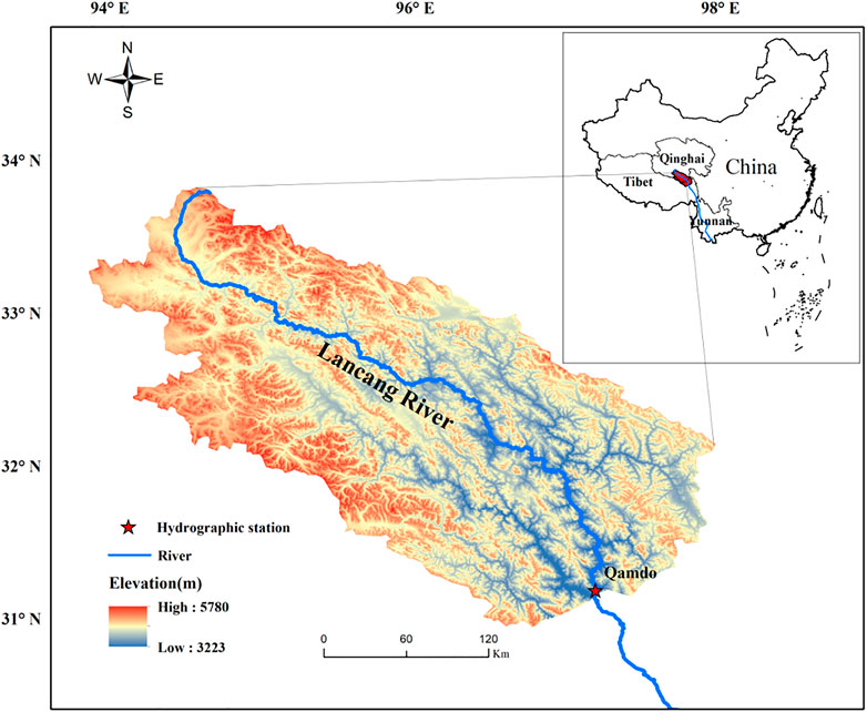
FIGURE 1. The location of the source area of Lancang River.
The data used in this study include: 1) the annual runoff observation data of the Qamdo hydrological station in 1961–2018 were obtained from the China Hydrologic Data Yearbook, 2) the meteorological observation data of the source area and surrounding areas of Lancang River in 1961–2018 from the China Meteorological Data Service Center (http://data.cma.cn/). Firstly, the Penman-Monteith formula was used to calculate the daily-scale potential evaporation data of 10 meteorological stations, and then the monthly-scale precipitation and potential evaporation data of 10 meteorological stations were obtained by summing the daily-scale data of 10 meteorological stations. Finally, the monthly precipitation and potential evaporation data were interpolated using Kriging method in ArcGIS software, the annual precipitation and potential evaporation were obtained by summing the monthly-scale data of 10 meteorological stations.
The Mann-Kendall method, which is non-parametric test that does not require assumption of normality of the data and can be used to determine whether there is a trend of data.
The Pettitt mutation analysis method is based on the Mann-Whitney non-parametric test (Pettitt, 1979). This method uses conforming rank-sum sequence to detect mutation points, which allows mutation analysis of hydro-meteorological element sequences to obtain mutation points and quantify the significance level of mutation points (Zhang and Song, 2015).
Budyko theory is based on water balance as follows (Saha et al., 2020):
Where P is amount of precipitation in mm, E is actual evaporation in mm, R is runoff depth in mm, and ΔS is water storage change in mm. There are three hypotheses in this study for distinguishing the impact of climate change and human activities on runoff: 1) assuming that human activities and climate change do not affect each other, and are independent factors; 2) For multi-year water balance, the change of water storage is usually negligible compared with the average annual precipitation depth. Therefore, Budyko hypothesis, based on an assumption that the change of catchment storage water for multi-year water balance is considered as 0; 3) assuming that the base period is only affected by climate change. Therefore, except for climate change, other factors affecting runoff are classified as human activities.
The Budyko hypothesis is expressed as follows:
Where ET0 is potential evaporation in mm.
Cloudhury (Choudhury, 1999) and Yang (Yang et al., 2008) proposed coupled hydrothermal equation to calculate the actual evaporation at long time scales based on the Budyko hypothesis as follows:
Where ω is dimensionless underlying surface parameter, related to soil properties, topography and vegetation (Xu et al., 2014). It is generally accepted that the multi-year average ΔS tends to zero in a closed region (Miao et al., 2022), under this assumption, combining Eq.1–3 yields the result as follows:
Assuming that P, ET0 and ω are independent variables, Eq. 3 combined with Eq. 4 are rewritten as
The degree of runoff change due to change in climate and human factors is expressed as follows:
Where
The
A complementarity method based on Budyko hypothesis is used to distinguish contribution of each factor to runoff changes. Zhou et al. proposed that complementary relationship based on elastic coefficient (Zhou et al., 2016), the elastic coefficient of runoff depth to P and ET0 have complementary relationship by assuming that P and ET0 are independent. The complementary relationship is defined as follows:
The P change, ET0 change, and ω are calculated as follows:
Where
The contribution of each impact factor to runoff changes is defined as follows:
Where x represents P, ET0 or ω, and
The Mann-Kendall method was used to analyze the interannual trend of runoff depth, P and ET0 in the source area of Lancang River from 1961 to 2018, and the results are shown in Table 1. It can be seen that the runoff depth, P and ET0 at Qamdo hydrological station are increasing, and the growth rates are 0.55mm/a, 1.57mm/a, 0.66mm/a. The Z value of runoff depth, P and ET0 are 0.94, 2.64 and 1.86 respectively. The runoff depth and ET0 do not pass the 95% (α=0.05) confidence test and show a non-significant increase trend, P pass the 99% (α=0.01) confidence test and show a significant increase trend.
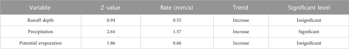
TABLE 1. Results of trend analysis of hydro-meteorological elements.
The Pettitt non-parametric mutation test was used to analyze the runoff at Qamdo hydrological station in the source area of Lancang River to determine mutation time. The mutation year obtained by the Pettitt test is 1966, and the results are shown in Figure 2.
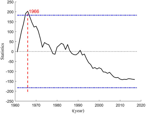
FIGURE 2. Pettitt test results of runoff at Qamdo hydrological station from 1961 to 2018.
Based on the results of the Pettitt test, the period 1961–1965 is set as the base period. In order to show the dynamic process of runoff and to satisfy that soil water content change can be ignored, 5 years are chosen as the time step. The average 5-year value is taken as the value for each time period and the soil water content change between the two adjacent periods is considered negligible. The difference between precipitation and runoff can be used as evaporation when the soil water content remains essentially constant for two adjacent periods. Therefore, the total time series (1961–2018) is divided into 12 periods, with the first 11 periods in 5-year time steps and the last one period in 3-year time steps.
The characteristic values of hydro-meteorological variables for 12 periods at Qamdo hydrological station in the source area of Lancang River are shown in Table 2. The runoff depth change is positively correlated with P change, and negatively correlated with ET0 and ω change. By comparing base period with change period, the elastic coefficient of P increased to different degrees, indicating that 10% increase in P increased runoff depth by 12.7% before 1966% and 13.3%–15.8% after 1966. This indicates that the sensitivity of runoff to P in the source area of Lancang River has increased in the last 58 years. The elastic coefficients of ET0 and ω decrease to different degrees, indicating that 10% increase in ET0 and ω reduced runoff depth by 2.7% and 7% before 1966, and by 3.3%–5.8% and 7.8%–9.9% after 1966 respectively. This indicates that the sensitivity of runoff to ET0 and ω in the source area of Lancang River has decreased in the last 58 years. By comparing the absolute magnitude value of the elastic coefficients of each impact factor, the descending order is P, ω, and ET0. The absolute magnitude value of the elastic coefficients indicates the degree of sensitivity of runoff to each impact factor.
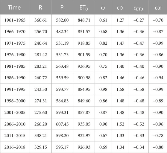
TABLE 2. The characteristic values of hydro-meteorological variables.
The Mann-Kendall method was used to analyze the interannual trends of the elastic coefficients of P, ET0 and ω in the source area of Lancang River from 1961 to 2018, and the results are shown in Table 3. The Z value of the elastic coefficient of P is 1.73, and the change trend of the elastic coefficient of P shows a significant increase. The Z values of the elastic coefficients of ET0 and ω are −1.73 and −0.28, respectively, and the change trend of the elastic coefficients of ET0 and ω show a significant decrease.
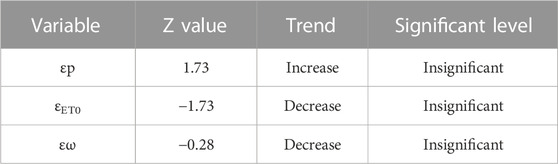
TABLE 3. The results of the trend analysis of the elastic coefficients of the precipitation, potential evaporation and underlying surface parameters.
The runoff depth, P, ET0, and ω in the source area of Lancang River were calculated, and the results are shown in Table 4. This table includes the values of change in runoff depth, P, ET0 and ω, the values of runoff depth changes due to change in P, ET0 and ω, and the contribution of P, ET0, and ω to runoff depth changes at Qamdo hydrological station in each change period.
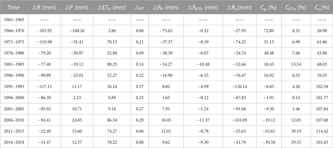
TABLE 4. Results of attribution analysis of runoff changes.
The period 1961–1965 is set as base period, compared with base period in the source area of Lancang River, the runoff depth decreased with a range of 22.4–119.98 mm in change periods, P decreased with a range of 19.12–100.26 mm before 1991 and increased with a range of 2.23–24.85 mm after 1991 in change periods, ET0 and ω increased with a range of 0.89–88.25 mm and 0.06–0.37 respectively in change periods. P change caused by runoff depth changes are different in change periods, showing a decrease range of 14.27–75.65 mm before 1991 and an increase range of 1.65–18.05 mm after 1991, ET0 and ω changes caused by runoff depth changes in change periods, showing a decrease range of 0.12–11.37 mm and 25.63–120.14 mm, respectively. In summary, P change make positive contribution to runoff changes, while ET0 and ω changes make negative contribution to runoff changes.
The contribution of changes in P, ET0 and ω to runoff depth changes are different in change periods. The contribution of P change to runoff depth changes was positive with a range of 16.92%–72.8% before 1990, and negative with a range of −1.91%–−53.61% after 1990. The contribution of ET0 and ω changes to runoff depth changes were positive with a range of 0.14%–39.19% and 26.9%–114.42%, respectively. In summary, the main impact factor for the decrease in runoff in the source area of Lancang River is ω, which impact the catchment process of runoff through interception, depression filling and infiltration. The P is the second impact factor, and ET0 is the least impact factor.
In this study, we analyzed the trends of meteorological and hydrological elements, identified the mutation year of runoff using Pettitt non-parametric test, and quantified the contribution of climate change and human activities to runoff changes using Budyko hypothesis method in the source area of Lancang River during 1961–2018. The main findings were 1) the annual runoff at Qamdo hydrological station showed non-significant increase, 2) the 1966 was the mutation year of runoff at Qamdo hydrological station, 3) The contribution of P to runoff changes ranged from 16.92% to 72.8% before 1990 and from −1.91% to −53.61% in 1990, the contribution of ET0 to runoff changes ranged from 0.14% to 39.19%, and the contribution of ω to runoff changes ranged from 26.9% to 114.42%. This study provides a new idea for water resources in the source area of Lancang River, and provides theoretical support for water resources management and ecological protection of Lancang River.
Although we quantitatively assesse the contribution of climate and human factors to runoff changes in the source area of Lancang River, uncertainties still exist. This study used traditional interpolation methods to process P and ET0 data from meteorological stations, ignored the impact of more factors (i.e., soil water content change and vegetation change) and the interaction between climate factors and human factors on runoff changes. These will make the study results biased to some extent. In the future, runoff change can be analyzed by improving the precision of meteorological data and considering more impact factors.
The data analyzed in this study is subject to the following licenses/restrictions: Apply for membership. Requests to access these datasets should be directed to China Meteorological Data Service Center (http://data.cma.cn/).
XY did the work of data curation and original draft preparation writing, CW did the work of validation, JD did the work of methodology, SQ did the work of project administration and review and editing, JL did the work of conceptualization.
This work was supported by the Basic Research Business Fund Project of Henan Academy of Sciences [grant number 220601003], Joint Fund for Scientific and Technological Research and Development Program of Henan Province [grant number 222103810100], Science and Technology Project of Henan Province [grant number 222102320257 and 212102310024], Major Research Focus Project of Henan Academy of Sciences [grant number 210101007], Central Government Guidance on Local Fund for Scientific and Technological Development [grant number 211201004], Special Project for Team Building of Henan Academy of Sciences[grant number 200501007].
The authors declare that the research was conducted in the absence of any commercial or financial relationships that could be construed as a potential conflict of interest.
All claims expressed in this article are solely those of the authors and do not necessarily represent those of their affiliated organizations, or those of the publisher, the editors and the reviewers. Any product that may be evaluated in this article, or claim that may be made by its manufacturer, is not guaranteed or endorsed by the publisher.
Bibi, S., Song, Q. H., Zhang, Y. P., Liu, Y., Kamran, M. A., Sha, L., et al. (2021). Effects of climate change on terrestrial water storage and basin discharge in the lancang River Basin. J. Hydrology: Regional Stud. 37, 100896. doi:10.1016/j.ejrh.2021.100896
Caracciolo, D., Pumo, D., and Viola, F. (2018). Budyko’s based method for annual runoff characterization across different climatic areas: An application to United States. Water Resour. Manag. 32 (9), 3189–3202. doi:10.1007/s11269-018-1984-7
Chen, D. L., Xu, B. Q., Yao, T. D., Guo, Z. T., Cui, P., Chen, F. H., et al. (2015). Assessment of past, present and future environmental changes on the Tibetan Plateau. Chin. Sci. Bull. 60 (32), 3025–3035. doi:10.1360/N972014-01370
Choudhury, B. J. (1999). Evaluation of an empirical equation for annual evaporation using field observations and results from a biophysical model. J. Hydrology 216 (1-2), 99–110. doi:10.1016/s0022-1694(98)00293-5
Donohue, R. J., Roderick, M. L., and Mcvicara, T. R. (2010). Can dynamic vegetation information improve the accuracy of Budyko’s hy-drological model? J. hydrology 390 (1-2), 23–34. doi:10.1016/j.jhydrol.2010.06.025
Ehsan Bhuiyan, M. A., Nikolopoulos, E. I., Anagnostou, E. N., Polcher, J., Albergel, C., Dutra, E., et al. (2019). Assessment of precipitation error propagation in multi-model global water resource reanalysis. Hydrology Earth Syst. Sci. 23 (4), 1973–1994. doi:10.5194/hess-23-1973-2019
Gao, Q. Z., Guo, Y. Q., Xu, H. M., Ganjurjav, H., Li, Y., Wan, Y., et al. (2016). Climate change and its impacts on vegetation distribution and net primary productivity of the alpine ecosystem in the Qinghai-Tibetan Plateau. Sci. Total Environ. 554, 34–41. doi:10.1016/j.scitotenv.2016.02.131
Gelati, E., Decharme, B., Calvet, J. C., Minvielle, M., Polcher, J., Fairbairn, D., et al. (2018). Hydrological assessment of at-mospheric forcing uncertainty in the Euro-Mediterranean area using a land surface model. Hydrology Earth Syst. Sci. 22 (4), 2091–2115. doi:10.5194/hess-22-2091-2018
Han, Z. Y., Long, D., Fang, Y., Hou, A., and Hong, Y. (2019). Impacts of climate change and human activities on the flow regime of the dammed Lancang River in Southwest Chinaflow regime of the dammed Lancang River in Southwest China. J. Hydrology 570, 96–105. doi:10.1016/j.jhydrol.2018.12.048
Immerzeel, W. W., Van Beek, L. P. H., and Bierkens, M. F. P. (2010). Climate change will affect the asian water towers. Science 328 (5984), 1382–1385. doi:10.1126/science.1183188
Jaiswal, R. K., Sohrat, A., and Birendra, B. (2020). Comparative evaluation of conceptual and physical rainfall-runoff models. Appl. water Sci. 10 (1), 48–14. doi:10.1007/s13201-019-1122-6
Ji, G., Wu, L., Wang, L., Yan, D., and Lai, Z. (2021). Attribution analysis of seasonal runoff in the source region of the yellow river using seasonal Budyko hypothesis. Land 10 (5), 542. doi:10.3390/land10050542
Ji, G. X., Huang, J. C., Guo, Y. L., and Yan, D. (2022). Quantitatively calculating the contribution of vegetation variation to runoff in the middle reaches of Yellow River using an adjusted Budyko formula. Land 11 (4), 535. doi:10.3390/land11040535
Ji, G. X., Song, H. Y., Wei, H. J., and Wu, L. (2021). Attribution analysis of climate and anthropic factors on runoff and vegetation changes in the source area of the Yangtze River from 1982 to 2016. Land 10 (6), 612. doi:10.3390/land10060612
Li, H. C., Wang, G. Q., Hao, Z. C., Liu, C. S., Liu, P. Y., Wu, C., et al. (2017). Characteristics analysis of hydrometeorological elements in Lancang River Basin. J. Water Resour. Water Eng. 28 (4), 21–27. doi:10.11705/j.issn.1672-643X.2017.04.04
Li, R. Z., Huang, H. Q., Yu, G. A., et al. (2021). Contributions of climatic variation and human activities to streamflow changes in the Lancang-Mekong River Basin. Resour. Sci. 43 (12), 2428–2441. doi:10.18402/resci.2021.12.06
Li, Z., Liu, W., Zhang, X., and Zheng, F. l. (2009). Impacts of land use change and climate variability on hydrology in an agricultural catchment on the Loess Plateau of China. J. Hydrology 377 (1-2), 35–42. doi:10.1016/j.jhydrol.2009.08.007
Liu, Y., Chen, W. Q., Li, L., Huang, J., Wang, X., Guo, Y., et al. (2023). Assessing the contribution of vegetation variation to streamflow variation in the Lancang River Basin, China. Front. Ecol. Evol. 10, 1058055. doi:10.3389/fevo.2022.1058055
Ma, H., Yang, D., Tan, S. K., Gao, B., and Hu, Q. (2010). Impact of climate variability and human activity on streamflow decrease in the Miyun Reservoir catchment. J. Hydrology 389 (3-4), 317–324. doi:10.1016/j.jhydrol.2010.06.010
Mango, L. M., Melesse, A. M., Mcclain, M. E., Gann, D., and Setegn, S. G. (2011). Land use and climate change impacts on the hydrology of the upper Mara River Basin, Kenya: Results of a modeling study to support better resource management. Hydrology earth Syst. Sci. 15 (7), 2245–2258. doi:10.5194/hess-15-2245-2011
Miao, Z. W, Lu, M., and Ding, Z. H. Cause analysis of runoff change in the upper reaches of Hutuo River based on time-varying Budyko-type equation. J. Yangtze River Sci. Res. Inst., 2022, 39(7):29–35. doi:10.11988/ckyyb.20210284
Pettitt, A. N. (1979). A non-parametric approach to the change-point problem. J. R. Stat. Soc. 28 (2), 126–135. doi:10.2307/2346729
Qi, S., Sun, G., Wang, Y., S. G. McNulty, , and J. A. Moore Myers, (2009). Streamflow response to climate and land use changes in a coastal watershed in North Carolina. Trans. ASABE 52 (3), 739–749. doi:10.13031/2013.27395
Zhao, Q. D., Ding, Y. J., Wang, J., Gao, H. K., Zhang, S. Q., Zhao, C. C., et al. (2019). Projecting climate change impacts on hydrological processes on the Tibetan Plateau with model calibration against the glacier inventory data and observed streamflow. J. Hydrology 573, 60–81. doi:10.1016/j.jhydrol.2019.03.043
Saha, A., Joseph, J., and Ghosh, S. (2020). Climate controls on the terrestrial water balance: Influence of aridity on the basin characteristics parameter in the Budyko framework. Sci. Total Environ. 739, 139863. doi:10.1016/j.scitotenv.2020.139863
Sun, L. X., Sun, Z. L., Li, Z. Y., Zheng, H., and Xiong, W. (2022). Response of runoff and suspended load to climate change and reservoir construction in the Lancang River. J. Water&Climate Change 13 (4), 1966–1984. doi:10.2166/wcc.2022.429
Sun, Y. S., Duan, S. Q., Li, Y., and Cao, G. C. (2015). Variation characteristics and trend analysis of runoff at the source regions of the Three River in Qinghai during recent years. J. Water Resour. Water Eng. 26 (1), 52–57. doi:10.11705/j.issn.1672-643X.2015.01.010
Tang, J., Yin, X. A., Yang, P., and Yang, Z. (2014). Assessment of contributions of climatic variation and human activities to streamflow changes in the Lancang River, China. Water Resour. Manag. 28, 2953–2966. doi:10.1007/s11269-014-0648-5
Tang, Q. H., Liu, X. C., Zhou, Y. Y., Wang, J., and Yun, X. B. (2019). Cascading impacts of Asian water tower change on downstream water systems. Bull. Chin. Acad. Sci. 34 (11), 1306–1312. doi:10.16418/j.issn.1000-3045.2019.11.013
Wang, G., Xia, J., and Chen, J. (2009). Quantification of effects of climate variations and human activities on runoff by a monthly water balance model: A case study of the chaobai River Basin in northern China. Water Resour. Res. 45 (7), W00A11. doi:10.1029/2007wr006768
Wang, Y. X., Liu, Z. P., Qian, B. W., He, Z., and Ji, G. (2022). Quantitatively computing the influence of vegetation changes on surface discharge in the middle-upper reaches of the Huaihe River, China. Forests 13 (12), 2000. doi:10.3390/f13122000
Xu, X., Yang, H., Yang, D., et al. (2013). Assessing the impacts of climate variability and human activities on annual runoff in the Luan River basin, China. Hydrology Res. 44 (5), 940–952. doi:10.2166/nh.2013.144
Xu, X. Y., Yang, D. W., Yang, H. B., and Lei, H. (2014). Attribution analysis based on the Budyko hypothesis for detecting the dominant cause of runoff decline in Haihe basin. J. Hydrology 510, 530–540. doi:10.1016/j.jhydrol.2013.12.052
Yan, D., Lai, Z. Z., and Ji, G. X. (2020). Using budyko-type equations for separating the impacts of climate and vegetation change on runoff in the source area of the yellow river. Water 12 (12), 3418. doi:10.3390/w12123418
Yang, H., Yang, D., Lei, Z., and Sun, F. (2008). New analytical derivation of the mean annual water-energy balance equation. Water Resour. Res. 44 (3), W03410. doi:10.1029/2007wr006135
Yao, T. D., Yu, W. S., Wu, G. J., Liu, S., Wang, N., et al. (2019). Glacier anomalies and relevant disaster risks on the Tibetan Plateau and surroundings. Chin. Sci. Bull. 64 (27), 2770–2782. doi:10.1360/tb-2019-0246
Zhai, H. J., Hu, B., Luo, X. Y., Qiu, L., Tang, W., and Jiang, M. (2016). Spatial and temporal changes in runoff and sediment loads of the Lancang River over the last 50 years. Agric. Water Manag. 174, 74–81. doi:10.1016/j.agwat.2016.03.011
Zhang, L., and Lu, G. S. (2016). Water cooperation under the Lancang-Mekong cooperation framework from the perspective of China’s emergency water released to Mekong River. Global Rev. 8 (2), 95–112&151–152. doi:10.13851/j.cnki.gjzw.201605006
Zhang, X., Dong, Q., Cheng, L., and Xia, J. (2019). A Budyko-based framework for quantifying the impacts of aridity index and other factors on annual runoff. J. Hydrology 579, 124224. doi:10.1016/j.jhydrol.2019.124224
Zhang, Y., Zhang, J. J., Zhang, Y. D., Zhai, Y. H., and Zhou, X. P. (2017). Spatial variation of long-term runoff trends and response to precipitation change in the Three-River Headwaters region. Res. Environ. Sci. 30 (1), 40–50. doi:10.13198/j.issn.1001-6929.2017.01.08
Zhang, Y. H., and Song, X. F. (2015). Techniques of abrupt change detection and trends analysis in hydroclimatic time-series: Advances and evaluation. Arid. Land Geogr. 38 (4), 652–665. doi:10.13826/j.cnki.cn65-1103/x.2015.04.002
Zhao, Z. P., Guan, X., Li, G., Zhai, J., Han, R. Y., Li, J. S., et al. (2017). Trend analysis of climatic change in the Three River Headwater region in Qinghai province during last 45 years. J. Arid Land Resour. Environ. 4 (31), 148–153. doi:10.13448/j.cnki.jalre.2017.125
Keywords: runoff, climate change, human activities, attribution analysis, lancang river
Citation: Yang X, Wang C, Du J, Qiu S and Liu J (2023) Dynamic evolution of attribution analysis of runoff based on the complementary Budyko equation in the source area of Lancang river. Front. Earth Sci. 11:1160520. doi: 10.3389/feart.2023.1160520
Received: 07 February 2023; Accepted: 06 March 2023;
Published: 23 March 2023.
Edited by:
Ning Niu, Henan University of Economic and Law, ChinaReviewed by:
Leying Wu, Henan University, ChinaCopyright © 2023 Yang, Wang, Du, Qiu and Liu. This is an open-access article distributed under the terms of the Creative Commons Attribution License (CC BY). The use, distribution or reproduction in other forums is permitted, provided the original author(s) and the copyright owner(s) are credited and that the original publication in this journal is cited, in accordance with accepted academic practice. No use, distribution or reproduction is permitted which does not comply with these terms.
*Correspondence: Chao Wang, wangchao@igs-has.cn
Disclaimer: All claims expressed in this article are solely those of the authors and do not necessarily represent those of their affiliated organizations, or those of the publisher, the editors and the reviewers. Any product that may be evaluated in this article or claim that may be made by its manufacturer is not guaranteed or endorsed by the publisher.
Research integrity at Frontiers
Learn more about the work of our research integrity team to safeguard the quality of each article we publish.