- 1State Key Laboratory of Geohazard Prevention and Geoenvironment Protection, Chengdu University of Technology, Chengdu, China
- 2China Railway Eryuan Engineering Group Co., Ltd., Chengdu, China
- 3State Environmental Protection Key Laboratory of Synergetic Control and Joint Remediation for Soil & Water Pollution, Chengdu University of Technology, Chengdu, China
An impact on vegetation by tunnel discharging has been a critical point for underground constructions around the world. The Jinping II hydropower station in China possesses the world’s largest karst diversion tunnel group and discharged massive groundwater during the construction period. This study assessed the effects on vegetation in the karst and non-karst areas at different stages before construction (2001–2003, BC), during construction (2004–2014, DC), and after construction (2015–2019, AC) based on the Normalized Difference Vegetation Index (NDVI) and the gross primary productivity (GPP) dataset of the moderate resolution-imaging spectroradiometer (MODIS). The regional median results of the NDVI and GPP showed that the whole vegetation was little changed by massive tunnel drainage throughout BC, DC, and AC. The NDVI and GPP were locally decreased in the first 3 years, and then recovered to the original level within next several years. Notably, the NDVI and GPP of the karst area (20 and 50% in the total area) were decreased more significantly than those of the non-karst area (8 and 20% in the total area). The factors controlling vegetation change are the development of karst and fractures, which are the conduits of groundwater flow. Therefore, massive groundwater discharge is the primary influence leading to the vegetation deterioration in the Jinping II hydropower station. The research would provide a vital reference for vegetation protection of large-scale underground construction in the world.
Introduction
Due to the population expansion and infrastructure development, underground construction has been extensively built around the world so far. Although large convenience is given, a series of geo-environmental problems, such as high in situ stresses, strong rock burst, large deformation of rock mass, high water pressures, and water inrush, have been represented (Wu and Wang 2011; Hou et al., 2016; Zhang et al., 2021a). A lot of research works have been carried out around these geo-environmental problems. Hou et al. (2016) proposed forecasting and prevention methods of water inrush prevention during the excavation process of a diversion tunnel at the Jinping II hydropower station. Zhang et al. (2016) have reported key technologies and risk management of deep tunnel construction aiming at issues on wall rock instability, strong rock burst, and high-pressure groundwater infiltration. Considering the ecological vulnerability of karst areas, previous study scarcely paid attention to the effects of underground construction on the eco-environment. For instance, destruction of aquifer structures, changing patterns of water resources, and influence on growth rates of plants are all the ecological and environmental problems that have been revealed (Lv et al., 2020). Vegetation is a crucial indicator of eco-environment evaluation and thus should be significantly considered during underground constructions (Zhang et al., 2021b). However, due to the complex geological conditions and limited observational data, the impacts of underground constructions on vegetation remain poorly understood in the Jinping hydropower station. The mechanisms how the tunnel group affects surficial vegetation have yet to be enhanced urgently.
Existing research mainly assessed the effects of underground constructions on vegetation using field investigation and sampling, such as plant types, species richness survey, and study of tree ring width (Yang et al., 2012; Wang et al., 2017; Lv et al., 2020). However, field survey is weak in reflecting long-term variation of surficial vegetation due to limited spatial and temporal scales. Meanwhile, field survey is costly and laborious. Remote sensing is a useful technique, which can present the spatial and temporal variation of surficial vegetation. As a high-resolution approach of remote sensing, the satellite-based Normalized Difference Vegetation Index (NDVI) has been useful to assess the impact of hydropower station on vegetation (Zhang P. et al., 2019; Zhang et al., 2020). However, the NDVI significantly relies on the amounts of “green” leaves and “green” degree, it could not fully retrieve vegetation variation (Myneni and Williams 1994; Zhengxing et al., 2003). Gross primary production (GPP) has the advantage in quantifying the total amount of carbon fixed by vegetation and is regarded as another significant index of vegetation analysis (Gilmanov et al., 2004; Phillips et al., 2008). Moreover, the GPP can reflect the stability of vegetation ecological function from the angle of carbon sequestration. However, few studies combined GPP and NDVI to assess the effects on vegetation of infrastructure with underground constructions, which may be a more accurate way for vegetation assessment.
The Jinping II hydropower project is located at the Liangshan Yi Autonomous Prefecture, Sichuan province, China. It is famous for the largest diversion tunnel group and developed karst and structures (fold and fault). So far, the massive water inrush, strong rock burst, and other typical geo-environmental problems have been analyzed in the construction (Shiyong et al., 2010; Wu and Wang 2011). However, few studies concentrated on the impact of large-sale underground construction of the Jinping II hydropower station on vegetation. In this study, the satellite-based NDVI and GPP were integrated to assess the spatial–temporal variation of surficial vegetation by the construction of the huge tunnel group in the Jinping II hydropower station. This study is aimed at 1) assessing the spatial–temporal effects on vegetation by groundwater discharging of the tunnel group during the tunnel construction; 2) comparing the vegetation variation to the tunnel construction in the karst and non-karst areas; 3) comparing the difference of GPP and NDVI in the evaluation for vegetation variation during tunnel construction; 4) proposing mitigation measures of an adverse impact on the surficial vegetation by tunnel construction. The achievement of this study would provide a vital reference for vegetation protection of large-scale underground construction in the world.
Study Area
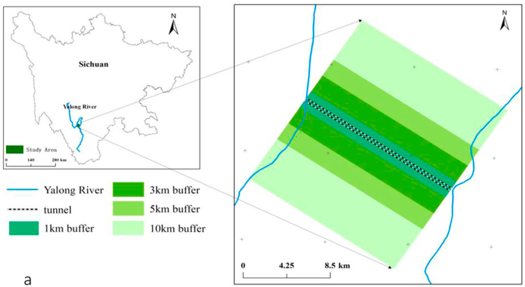
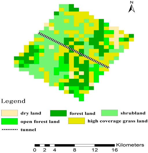
Our study area was located in the lower reaches of the Yalong River where the river is barred by a Jinping Mountain, forming a river bend with a length of 150 km (Figure 1). As part of the Jinping Mountain, the study area has a steep terrain and alpine landscape with strong cutting structures and numerous mountains that possess elevations over 3,000 m. The study area belongs to the climatic area of the western Sichuan plateau, which presents a distinguished wet or dry season. The annual rainfall is approximately 821.3 mm, and the large rainfall months are from June to September. Annual average temperature fluctuated approximately from 13 to 15°C during the construction periods of the Jinping II hydropower station. According to the land cover map of the study area, the vegetation types are mainly forest land, shrub land, open forest land, and high coverage grass land (Figure 2).
Tectonically, the study area is located in the eastern margin of the Qinghai–Tibet Plateau (Zhang Y.-h. et al., 2019). The stratigraphic time of our study areas includes the following: the Yantang Formation of the middle Triassic (T2y), which includes three rock formations (T42y, T52y, and T62y), the Baishan Formation of the middle Triassic (T2b) and the upper Triassic (T3), the Zagunao Formation of the middle Triassic (T2z), and the Mojian Formation of the lower Triassic (T1) (Figure 3).The Triassic strata (T1, T2z, T2b, T2y, and T3) accounts for more than 90% of the study area, which could be divided into the karst and non-karst strata according to lithology. The formations of T2y and T2b consisted of soluble crystalline, limestone, and marble, which were the karst strata in the study area, while, the formation of T3 was mainly made up of insoluble sandstone. The formation of T2z was primarily composed of insoluble argillaceous limestone. The formation of T1 was chiefly formed by insoluble chlorite schist. The formations of T3,T2z, and T1 were the non-karst strata in the study area.
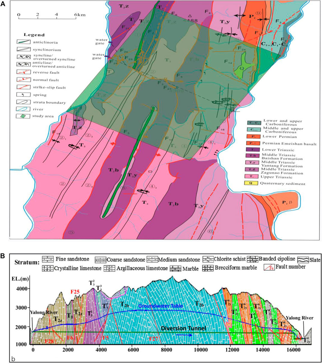
FIGURE 3. Geological map of the study areas (A) and cross section of the No.1 headrace tunnel (B) (Hou et al., 2016).
Based on the geological survey, a series of complex folds with a nearly north–south distribution formed in these Triassic strata. These folds contain anticline and overturned anticline, syncline and overturned syncline, and a lot of compound anticlines and synclines (Figure 3A). Due to the strong tectonism in these folded zones, a great deal of faults appeared in the study area type of which included compression faults, compression shear faults, extensional faults, and tension–torsion faults. La Shagou-Yi Wanshui Fault, Jinping Mountain Fault, and Shang Shoupa Fault are the main faults in this region. Joints and fissures are highly developed in the folds and faults area. They have a great impact on groundwater distribution and movement, and thus controlled the water inrush process of the tunnel construction to a certain extent. The karst strata run NNE (north–north–east) and are mainly distributed in the central part of the Jinping Mountain. Karst development in the study area is weak on the whole, and there is no stratified karst system. Below 2,000 m, the karst development is weak and dominated by a vertical system. The deep karst is dominated by NEE (east–northeast) and NWW (northwest–west) trending tectonic fractures and their intersecting zones enlarged by dissolution. Karst morphology near the elevation of the diversion tunnel (1,600 m) is dominated by karst fractures, with few karst caves in small scale.
A tunnel group passing through the Jinping Mountain is the important part of the Jinping hydropower project. The tunnel group consists of seven parallel tunnels. From south to north, they are two auxiliary tunnels (17.5 km in length), one drainage tunnel (16.7 km in length), and four diversion tunnels (16.7 km in length). The two auxiliary tunnels began its construction in October, 2003 and were completed in July, 2008. Construction of the four diversion tunnels started in January, 2007. The whole project was completed in November, 2014. The seven parallel tunnels were buried with the depth of 1,500–2000 m. (Shiyong et al., 2010; Wu and Wang 2011; Hou et al., 2016; Jalali and Jalali 2016; Santaloia et al., 2016; Shi et al., 2017). These tunnels went through karst cave aquifer composed of the T2b and T2y strata, and the fissure aquifer was formed by the T2z strata. The seven tunnels also have a similar cross section as shown in Figure 3B. The groundwater was recharged mainly in the higher bedrock mountains with an elevation of 3000–4000 m. The water table of the groundwater was nearly a kilometer deep. After a long-distance runoff from high- to low-lying areas, the groundwater finally discharged into the Yalong River. Also, springs were another groundwater discharging type when the groundwater migrated in short distance and then flowed into nearby valleys. Low flow water inrush occurred mainly in the non-karst strata, while large flow water inrush mainly occurred in the karst strata during tunnel construction (Hou et al., 2016). During the tunnel construction process, several water inrush disasters occurred in the diversion tunnels, which can be divided into different types. The typical water inrush disasters in the diversion tunnel during the construction process, such as low flow water inrush in the joints or fractures, large flow water inrush in the faults with high pore water pressure, water inrush with silt in the fractures or faults, and water inrush with bubbles in the structural surfaces (Hou et al., 2016).
Methods
In this study, MODIS-NDVI (MODIS13Q1) with a spatial resolution of 250 m × 250 m and temporal resolution of 16 days and GPP (MOD17A2H) with a spatial resolution of 500 m × 500 m and temporal resolution of 8 days from January 2001 to December 2019 were obtained from the National Aeronautics and Space Administration (NASA) (https://ladsweb.modaps.eosdis.nasa.gov/search). The annual NDVIs were extracted from every 16-day NDVI raster datasets in a whole year by the maximum value composites method. The annual GPPs were obtained by summing the 8-day GPP raster datasets in a whole year.
Since the tunnel construction lasted from 2004 to 2014, study periods of 2000–2019 were separated into three stages. The period of 2000–2003 were defined as before construction (BC), which could serve as a benchmark for vegetation without tunnel construction. The period of 2004–2014 and 2015–2019 were defined as “during construction” (DC) and “after construction” (AC). The mean value of annual NDVIs and annual GPPs of 2001–2003, 2004–2014, and 2015–2019 were extracted as the NDVI of BC, DC, and AC, respectively. The one-way analysis of variance (ANOVA) was performed to compare GPP and NDVI of BC, DC, and AC in both the karst and non-karst areas. Tukey-HSD was applied for multiple comparisons if the difference was significant at p < 0.05 (Brunneret al. 2017; Kozak and Piepho 2018).
Spatial changes of annual NDVI and GPP throughout the DC and AC were identified by the comparison between annual NDVIs and GPPs of 2004–2019 and the mean value of annual NDVIs and GPPs of 2001–2003. Negative NDVI or GPP in each pixel presented vegetation degradation, while positive NDVI or GPP in each pixel presented vegetation growth. To further recognize the location of the negative NDVI and GPP, pixels with positive NDVI and GPP were assigned to null and displayed as colorless.
All the data were analyzed in the R environment (Version 4.1.2, http://cran.r-project.org), and the packages for R are available in this study (https://cran.r-project.org/web/packages/raster/index.html;https://cran.rproject.org/web/packages/multcomp/index.html).
Results and Discussion
General Characteristics of the Normalized Difference Vegetation Index and Gross Primary Productivity
Regardless of different construction periods, the NDVI and GPP presented great spatial variabilities in both the karst and non-karst areas within the 10 km range on both sides of the diversion tunnel group (Figure 4). In karst areas, the lowest NDVI and GPP were identified in the northern and middle parts, while the highest NDVI and GPP were observed in the northeastern and eastern segments (Figures 4A,B). Similarly, great variabilities were still observed in non-karst areas (Figures 4C,D). Compared with karst areas, non-karst areas possessed the lower spatial variabilities of the NDVI and GPP.
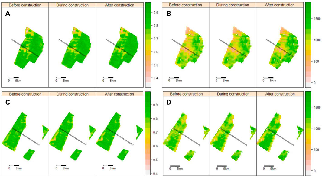
FIGURE 4. Spatial distribution of mean NDVI (A,C) and GPP (B,D) before, during, and after constructions in the non-karst (A,B) and karst areas (C,D).
The variations of the mean NDVIs and GPPs during the BC, DC, and AC are shown in Figure 5. The NDVI and GPP of the BC, DC, and AC changed little at the regional scale. The NDVI value was 0.81 for karst areas and 0.84 for non-karst areas during the BC, respectively. The NDVI of the DC was slightly lower (<0.01) than that of the BC. On the contrary, the NDVI of the AC was higher (<0.02) than that of the BC. Similarly, the GPP value of BC was 952 g C m−2 year−1 for the karst area and 1,112 g C m−2 year−1 for the non-karst area. The GPP of DC and AC showed a modest increase (<150 g C m−2 year−1) compared with that of BC. Similar changes were also found for areas within the distances of 1, 3, and 5 km on both sides of the diversion tunnel group (Supplementary Figure 2).
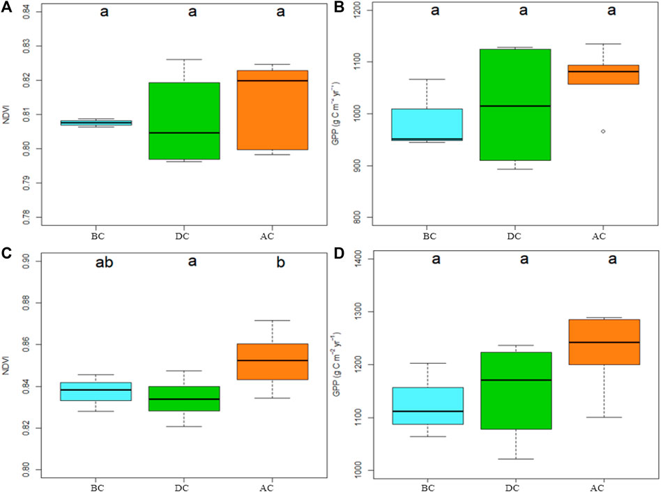
FIGURE 5. Boxplot for mean annual NDVI (A,C) and GPP (B,D) before, during, and after tunnel constructions in the karst (A,B) and non-karst areas (C,D). Means followed by a common letter above the error bars are not significantly different at the significance level of 5%.
The aforementioned results indicated that tunnel construction of the Jinping II hydropower station had a subtle influence on vegetation growth at the regional scale. This is consistent with the results by the net primary production proxy in the hydropower stations along the Wujiang River in southwestern China (Sun et al. (2018). Although previous studies indicated that underground construction (e.g., railway tunnel) may be unbeneficial for vegetation growth due to the loss of groundwater during the DC (Lv et al., 2020), the effects of tunnel construction on vegetation is largely dependent on climate and groundwater burial condition. For example, vegetation in the areas with abundant precipitation was affected by surface water rather than groundwater during tunnel construction (Wang et al., 2007; Craig et al., 2013). The annual precipitation was abundant (>1,000 mm) in our survey region throughout the BC, DC, and AC (Supplementary Figure 5). Thus, the vegetation growth in our study area was closely related to surface water due to ample annual precipitation. In addition, the groundwater table might be another notable factor to interpret the weak variation in the NDVI and GPP. The groundwater depth was larger than 1 km (Figure 1); however, vegetation only made use of the groundwater from tens of centimeters up to several meters underground (Warner et al., 2013; Mathurin et al., 2014). Therefore, surface water, as the main water source of vegetation, was more strongly correlated with vegetation growth in our study area.
Local Characteristics of the Normalized Difference Vegetation Index and Gross Primary Productivity
Although mean NDVI and GPP had no significant variations among different construction periods regionally, the NDVI and GPP illustrated notable variation in some local areas. By field survey, structures (fold and fault) and karst are developed in the study area. Considering their special hydrogeological affinity, structures (fold and fault) and karst are the possible factors leading to local vegetation variation.
A lot of pixels in both karst and non-karst areas revealed negative NDVI and GPP in the first few years (2004–2007) of DC (Figures 6, 7, Supplementary Figure 5). Negative NDVI and GPP were mainly scattered over the fault zones and fold core parts in the study area (Figure 3). This may be attributed to dense fractures distributed in the fold core and fault zones, which are favorable for groundwater moving and storage (Hou et al., 2016; Zhang et al., 2016; Lv et al., 2020). Large volume of high-pressure inrush water was encountered during tunnel construction in these fold core or fault zones where rock mass was extremely broken and plenty of fractures were developed (Jalali and Jalali 2016). Forty-two groundwater infiltration points were exposed when four diversion tunnels went through the fold and fault areas. Seven of 42 infiltration points experienced water gushing greater than 1 m3/s, and others had groundwater inflow greater than 0.05 m3/s (Zhang et al., 2016). Jalali and Jalali,(2016) also counted that 20 infiltration points with groundwater gushing higher than 0.1 m3/s were disclosed during the construction of the auxiliary tunnels. The infiltration points were also mainly located in the tunnel segments which passed through the fold core or fault zones. Therefore, fracture in the fold core and fault zones influenced the distribution of vegetation deterioration.
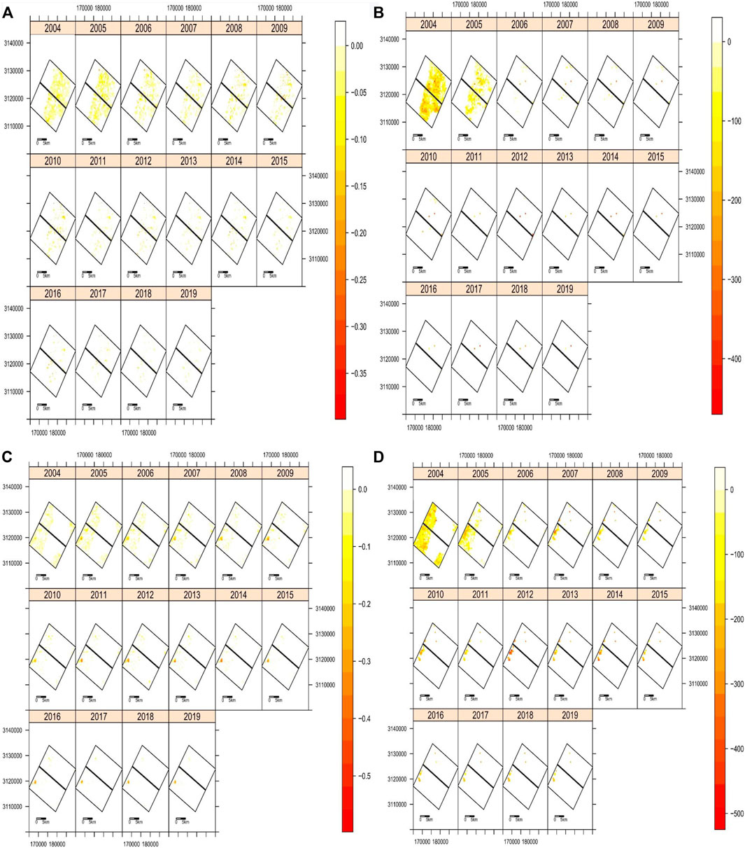
FIGURE 6. Spatial distribution of negative NDVI (A,C) and GPP (B,D) throughout DC and AC in the karst (A,B) and non-karst areas (C,D).
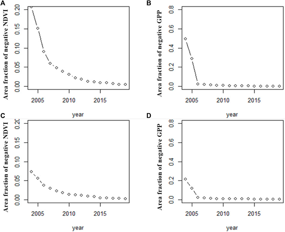
FIGURE 7. Area fraction of negative NDVI (A,C) and GPP (B,D) throughout DC and AC in the karst (A,B) and non-karst areas (C,D) in the study area.
On the other hand, karst was another significant factor leading to a large area decline in the NDVI and GPP results. Negative NDVI values accounted for 20% of the karst areas and only 8% of the non-karst areas in the first year of DC (Figures 7A,C). The GPP values showed similar changes with the NDVI, representing 50% decline in karst areas and 20% decline in non-karst areas in the first year of DC (Figures 7B,D). In addition, the area fractions of the negative GPP were higher than that of the NDVI. The results indicated that vegetation in karst areas were more sensitive to tunnel construction compared to non-karst areas. It was probably resulted from the special characteristics of the karst hydrological system that is disadvantageous for vegetation growth by the following reasons: 1) The karst hydrological system was characterized by vulnerable karst aquifers and dominant subsurface drainage, which were sensitive to tunnel construction (Gutiérrez et al., 2014). It was predicted that the groundwater discharge by the diversion tunnel group was about 19–23.5 m3/s in karst areas, two times more than that in non-karst areas (Ren et al., 2009). Such massive groundwater drainage resulted in dry surface habitats and water shortages due to the direct connection between the surface and underlying high-permeability aquifers in the karst hydrological system (Lv et al., 2020). 2) The groundwater discharge may lead to karst collapse and soil erosion. Karst collapse would directly destroy vegetation, while soil erosion may inhibit soil providing water and nutrition for vegetation. 3) The underground pipeline network varying greatly in different areas can be easily blocked in lower areas in cases of heavy rain, causing local waterlogging and water–soil loss (Lv et al., 2020).
Despite widespread negative NDVI and GPP values for the first few years of DC in the study area, a minority of the pixels displayed negative NDVI values after 2010 and GPP values after 2006 (Figures 6, 7, Supplementary Figure 5). This indicated that vegetation growth dropped down in the first few years of DC and then recovered to the initial state after several years. Such result was not consistent to previous report which deemed that the tunnel construction led to a significant vegetation reduction in pine forests using the tree ring approach (Zheng et al., 2017). However, our result was similar to that of some hydropower projects on the Jinsha River (Zhang P. et al., 2019). It is probably because the vegetation adapted new hydrogeological conditions. Also, this might be due to the efficient groundwater treatments, significantly limiting water gushing during tunnel construction. Water plugging was the primary treatment method to resolve the water gushing with a low flow rate. Meanwhile, advanced and specific technologies were also utilized to treat concentrated groundwater infiltration with a high flow rate (Zhang et al., 2016). Moreover, vegetation restoration and comprehensive management of ecological construction projects after infrastructure constructions were possible reasons for the recovery of the NDVI or GPP values (Wei et al., 2010; Zhang P. et al., 2019). However, due to the lack of field and remote sensing data on vegetation restoration, it was difficult to eliminate the effects of climate and human activities on the increase of the NDVI and GPP values in the current study.
In addition, a lot of articles proposed that the variation of GPP and NDVI have close relationship with climate factors, especially with precipitation and temperature.(Wang et al., 2007; Zhang et al., 2013; You et al., 2020). In order to identify the effects of climate change on vegetation, Spearman bivariate correlation analysis was used to analyze the correlation of GPP and NDVI with precipitation and temperature. The Spearman correlation coefficient of most pixels was between −0.3 and 0.3, indicating a weak relationship between GPP and NDVI change with the climate factors (precipitation and temperature) (Figure 8).
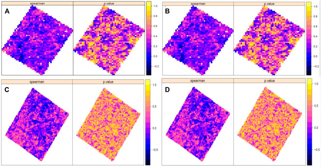
FIGURE 8. Correlation coefficient and its significance testing results between vegetation GPP, NDVI, and climate factors [(A) between GPP and precipitation; (B) between GPP and temperature; (C) between NDVI and precipitation; and (D) between NDVI and temperature].
Proposal
First, groundwater discharging by the tunnel would not lead to extensive vegetation degradation in the humid region. Vegetation distributed in areas where karst was highly developed, or structures were concentrated would be an impact to some extent. Advance grouting or curtain grouting in areas where karst was highly developed, or structures were concentrated would be an effective way to protect vegetation during tunnel construction. It is also important to strengthen the vegetation monitoring.
Second, although the NDVI has been widely used to evaluate the impact of engineer construction, saturation problem is a well-known issue in the NDVI. The NDVI can reach saturation and become insensitive in dense vegetation canopies. (Asner et al., 2003; Gu et al., 2013). This may lead to an underestimation of ecosystem productivity in high (dense) biomass regions. While GPP, which is the total amount of organic carbon fixed by green plants through photosynthesis at an ecosystem scale, determines the initial amount of energy and material entering the terrestrial ecosystem (Dagnachew et al., 2020). Thus, GPP could reflect the stability of vegetation ecological structure and its ecological function (Wang et al., 2021). In this way, it overcomes the limitation of saturation problem in the NDVI. Therefore, in our study, it was found that negative NDVI values covered about 20% of the study area, while the areas of negative GPP values amounted to 55% the first year after tunnel construction.
Therefore, it is recommended that combining GPP or other ecological parameters with the NDVI would be more accurate to assess the impacts on vegetation of groundwater discharging by underground construction. On the other hand, although our study highlighted vegetation recovered in a few years after tunnel construction in terms of the NDVI and GPP, it could not reflect the vegetation structure variation. How vegetation recovered in terms of vegetation structure still needs to be further studied.
Conclusion
This research was conducted to assess the spatial and temporal impacts on vegetation by tunnel discharging in the Jinping II hydropower station from 2001 to 2019. Generally, the tunnel construction had a negligible impact on vegetation at the regional scale due to the abundant precipitation in the study area. However, the response of vegetation to the construction of the Jinping hydropower station varied spatially. The negative NDVI and GPP values were mainly distributed in areas where karst was highly developed, or structures were concentrated. In addition, about 20% of the total area for NDVI values and 50% for GPP values were negative after the first year of the tunnel construction in karst areas. Afterward, the NDVI and GPP values recovered to the original level after 7 and 3 years, respectively. The area for the decrease of the NDVI and GPP values in non-karst regions was much smaller than that of karst areas, due to insoluble affinity of non-karst strata and smaller volume of groundwater discharge. Both the NDVI and GPP values increased during the AC compared to those of BC, because of the vegetation restore and comprehensive groundwater treatment measures in tunnels. The research proposed that massive groundwater gushing would be unbeneficial for vegetation growth. The karst and structures areas should be paid more attention to prevent vegetation deterioration during tunnel construction. Advanced geological forecast and effective water plugging methods would be helpful for vegetation protection.
Data Availability Statement
The original contributions presented in the study are included in the article/Supplementary Material, further inquiries can be directed to the corresponding author.
Author Contributions
All authors listed have made a substantial, direct, and intellectual contribution to the work and approved it for publication.
Funding
This research was funded by the Major Program of the National Natural Science Foundation of China (Grant No. 41790445). This study was primarily supported by the Everest Scientific Research Program of Chengdu University of Technology (80000-2021ZF11410), the influence of Sichuan–Tibet railway tunnel project on typical forest ecosystem (KDNQ213070), and the key technologies of mountain rail transit green construction in the ecologically sensitive region based on mountain rail transit from Dujiangyan to Mt. Siguniang antipoverty project (2018-zl-08).
Conflict of Interest
Author CS was employed by the company China Railway Eryuan Engineering Group Co., Ltd.
The remaining authors declare that the research was conducted in the absence of any commercial or financial relationships that could be construed as a potential conflict of interest.
Publisher’s Note
All claims expressed in this article are solely those of the authors and do not necessarily represent those of their affiliated organizations, or those of the publisher, the editors, and the reviewers. Any product that may be evaluated in this article, or claim that may be made by its manufacturer, is not guaranteed or endorsed by the publisher.
Supplementary Material
The Supplementary Material for this article can be found online at: https://www.frontiersin.org/articles/10.3389/feart.2022.863278/full#supplementary-material
References
Asner, G. P., Scurlock, J. M. O., and A. Hicke, J. (2003). Global Synthesis of Leaf Area index Observations: Implications for Ecological and Remote Sensing Studies. Glob. Ecol. Biogeogr. 12 (3), 191–205. doi:10.1046/j.1466-822x.2003.00026.x
Brunner, P., Therrien, R., Renard, P., Simmons, C. T., and Hendricks Franssen, H.-J. (2017). Advances in Understanding River - Groundwater Interactions. Rev. Geophys. 55, 818–854. doi:10.1002/2017RG000556
Craig, J., Absar, A., Bhat, G., Cadel, G., Hafiz, M., Hakhoo, N., et al. (2013). Hot springs and the Geothermal Energy Potential of Jammu & Kashmir State, N.W. Himalaya, India. Earth-Science Rev. 126, 156–177. doi:10.1016/j.earscirev.2013.05.004
Dagnachew, M., Kebede, A., Moges, A., and Abebe, A. (20202020). Effects of Climate Variability on Normalized Difference Vegetation Index (NDVI) in the Gojeb River Catchment, Omo-Gibe Basin, Ethiopia. Adv. Meteorology 2020, 1–16. doi:10.1155/2020/8263246
Gilmanov, T. G., Johnson, D. A., Saliendra, N. Z., Akshalov, K., and Wylie, B. K. (2004). Gross Primary Productivity of the True Steppe in Central Asia in Relation to NDVI: Scaling up CO2 Fluxes. Environ. Manage. 33 (S1), S492–S508. doi:10.1007/s00267-003-9157-7
Gu, Y., Wylie, B. K., Howard, D. M., Phuyal, K. P., and Ji, L. (2013). NDVI Saturation Adjustment: A New Approach for Improving Cropland Performance Estimates in the Greater Platte River Basin, USA. Ecol. Indicators 30, 1–6. doi:10.1016/j.ecolind.2013.01.041
Gutiérrez, F., Parise, M., De Waele, J., and Jourde, H. (2014). A Review on Natural and Human-Induced Geohazards and Impacts in Karst. Earth-Science Rev. 138, 61–88. doi:10.1016/j.earscirev.2014.08.002
Hou, T.-x., Yang, X.-g., Xing, H.-g., Huang, K.-x., and Zhou, J.-w. (2016). Forecasting and Prevention of Water Inrush during the Excavation Process of a Diversion Tunnel at the Jinping II Hydropower Station, China. Springerplus 5 (1), 700. doi:10.1186/s40064-016-2336-9
Jalali, M., and Jalali, M. (2016). Geochemistry and Background Concentration of Major Ions in spring Waters in a High-Mountain Area of the Hamedan (Iran). J. Geochemical Exploration 165, 49–61. doi:10.1016/j.gexplo.2016.02.002
Kozak, M., and Piepho, H.-P. (2018). What's normal Anyway? Residual Plots Are More Telling Than Significance Tests when Checking ANOVA Assumptions. J. Agro Crop Sci. 204 (1), 86–98. doi:10.1111/jac.12220
Lv, Y., Jiang, Y., Hu, W., Cao, M., and Mao, Y. (2020). A Review of the Effects of Tunnel Excavation on the Hydrology, Ecology, and Environment in Karst Areas: Current Status, Challenges, and Perspectives. J. Hydrol. 586, 1–15. doi:10.1016/j.jhydrol.2020.124891
Mathurin, F. A., Åström, M. E., Drake, H., Maskenskaya, O. M., and Kalinowski, B. E. (2014). REE and Y in Groundwater in the Upper 1.2 Km of Proterozoic Granitoids (Eastern Sweden) - Assessing the Role of Composition and Origin of Groundwaters, Geochemistry of Fractures, and Organic/inorganic Aqueous Complexation. Geochimica et Cosmochimica Acta 144, 342–378. doi:10.1016/j.gca.2014.08.004
Myneni, R. B., and Williams, D. L. (1994). On the Relationship between FAPAR and NDVI. Remote Sensing Environ. 49, 200–211. doi:10.1016/0034-4257(94)90016-7
Phillips, L. B., Hansen, A. J., and Flather, C. H. (2008). Evaluating the Species Energy Relationship with the Newest Measures of Ecosystem Energy: NDVI versus MODIS Primary Production. Remote Sensing Environ. 112 (9), 3538–3549. doi:10.1016/j.rse.2008.04.012
Ren, X., Shu, J., Shan, Z., and Liu, Y. (2009). Research on Groundwater Transport, Influence and Control in Tunnel Group of Jinping II Hydropower Station during Construction. Chin. J. Rock Mech. Eng. 28 (Suppl. 1), 2892–2897. doi:10.3321/j.issn:1000-6915.2009.z1.045
Santaloia, F., Zuffianò, L. E., Palladino, G., Limoni, P. P., Liotta, D., Minissale, A., et al. (2016). Coastal thermal Springs in a Foreland Setting: The Santa Cesarea Terme System (Italy). Geothermics 64, 344–361. doi:10.1016/j.geothermics.2016.06.013
Shi, Z., Liao, F., Wang, G., Xu, Q., Mu, W., and Sun, X. (20172017). Hydrogeochemical Characteristics and Evolution of Hot Springs in Eastern Tibetan Plateau Geothermal Belt, Western China: Insight from Multivariate Statistical Analysis. Geofluids 2017, 1–11. doi:10.1155/2017/6546014
Shiyong, W., Manbin, S., and Jian, W. (2010). Jinping Hydropower Project: Main Technical Issues on Engineering Geology and Rock Mechanics. Bull. Eng. Geol. Environ. 69 (3), 325–332. doi:10.1007/s10064-010-0272-4
Sun, J., Hunter, P. D., Cao, Y., Doeser, A., and Li, W. (2018). Response of Terrestrial Net Primary Productivity (NPPT) in the Wujiang Catchment (China) to the Construction of cascade Hydropower Stations. Inland Waters 8 (2), 239–253. doi:10.1080/20442041.2018.1442672
Wang, C.-J., Zhang, Z. X., and Wan, J.-Z. (2021). Relationship between Gross Primary Productivity and Plant Species Richness at Geographical Scales: Evidence from Protected Area Data in China. Environ. Earth Sci. 80 (5). doi:10.1007/s12665-021-09503-y
Wang, J., Meng, J. J., and Cai, Y. L. (2007). Assessing Vegetation Dynamics Impacted by Climate Change in the Southwestern Karst Region of China with AVHRR NDVI and AVHRR NPP Time-Series. Environ. Geol. 54 (6), 1185–1195. doi:10.1007/s00254-007-0901-9
Wang, Z., Li, Q., Huang, Z., Tang, X., and Zhao, W. (2017). Ecological Footprint Analysis of Environmental Impacts by Cascaded Exploitation of Diversion-type Small Hydropower: a Case Study in Southwest china. IOP Conf. Ser. Earth Environ. Sci. 64, 012056. doi:10.1088/1755-1315/64/1/012056
Warner, N. R., Kresse, T. M., Hays, P. D., Down, A., Karr, J. D., Jackson, R. B., et al. (2013). Geochemical and Isotopic Variations in Shallow Groundwater in Areas of the Fayetteville Shale Development, north-central Arkansas. Appl. Geochem. 35, 207–220. doi:10.1016/j.apgeochem.2013.04.013
Wei, L., Li, S., Sun, H., Zhou, J., Peng, X., and Hu, M. (2010). Dynamic Characteristics of Vegetation Restoration in Geotechnical Residue Field of Jinping Hydropower Station. Chin. J. Ecol. 29 (02), 250–255. doi:10.1016/S1872-5813(11)60001-7
Wu, S., and Wang, G. (2011). Rock Mechanical Problems and Optimization for the Long and Deep Diversion Tunnels at Jinping II Hydropower Station. J. Rock Mech. Geotechnical Eng. 3 (4), 314–328. doi:10.3724/sp.j.1235.2011.00314
Yang, F., Liu, W.-W., Wang, J., Liao, L., and Wang, Y. (2012). Riparian Vegetation's Responses to the New Hydrological Regimes from the Three Gorges Project: Clues to Revegetation in Reservoir Water-Level-Fluctuation Zone. Acta Ecologica Sinica 32 (2), 89–98. doi:10.1016/j.chnaes.2012.02.004
You, N., Meng, J., Zhu, L., Jiang, S., Zhu, L., Li, F., et al. (2020). Isolating the Impacts of Land Use/Cover Change and Climate Change on the GPP in the Heihe River Basin of China. J. Geophys. Res. Biogeosciences 125 (10), 1–17. doi:10.1029/2020jg005734
Zhang, C., Liu, N., and Chu, W. (2016). Key Technologies and Risk Management of Deep Tunnel Construction at Jinping II Hydropower Station. J. Rock Mech. Geotechnical Eng. 8 (4), 499–512. doi:10.1016/j.jrmge.2015.10.010
Zhang, P., Cai, Y., Yang, W., Yi, Y., Yang, Z., and Fu, Q. (2019). Multiple Spatio-Temporal Patterns of Vegetation Coverage and its Relationship with Climatic Factors in a Large Dam-Reservoir-River System. Ecol. Eng. 138, 188–199. doi:10.1016/j.ecoleng.2019.07.016
Zhang, P., Cai, Y., Yang, W., Yi, Y., Yang, Z., and Fu, Q. (2020). Contributions of climatic and anthropogenic drivers to vegetation dynamics indicated by NDVI in a large dam-reservoir-river system. J. Clean. Product. 256, 1–11.
Zhang, Y.-h., Wang, Y.-s., Wang, W.-s., Liu, J., and Yuan, L.-l. (2019). Zircon U-Pb-Hf Isotopes and mineral Chemistry of Early Cretaceous Granodiorite in the Lunggar Iron deposit in central Lhasa, Tibet Y, China. J. Cent. South Univ. 26, 3457–3469. doi:10.1007/s11771-019-4266-5
Zhang, Y., Dai, Y., Wang, Y., Huang, X., Xiao, Y., and Pei, Q. (2021a). Hydrochemistry, Quality and Potential Health Risk Appraisal of Nitrate Enriched Groundwater in the Nanchong Area, Southwestern China. Sci. Total Environ. 784, 147186. doi:10.1016/j.scitotenv.2021.147186
Zhang, Y., Gao, J., Liu, L., Wang, Z., Ding, M., and Yang, X. (2013). NDVI-based Vegetation Changes and Their Responses to Climate Change from 1982 to 2011: A Case Study in the Koshi River Basin in the Middle Himalayas. Glob. Planet. Change 108, 139–148. doi:10.1016/j.gloplacha.2013.06.012
Zhang, Y., He, Z., Tian, H., Huang, X., Zhang, Z., Liu, Y., et al. (2021b). Hydrochemistry Appraisal, Quality Assessment and Health Risk Evaluation of Shallow Groundwater in the Mianyang Area of Sichuan Basin, Southwestern China. Environ. Earth Sci. 80 (17), 576. doi:10.1007/s12665-021-09894-y
Zheng, W., Wang, X., Tang, Y., Liu, H., Wang, M., and Zhang, L. (2017). Use of Tree Rings as Indicator for Groundwater Level Drawdown Caused by Tunnel Excavation in Zhongliang Mountains, Chongqing, Southwest China. Environ. Earth Sci. 76 (15), 1–14. doi:10.1007/s12665-017-6859-3
Keywords: groundwater discharging, karst, fracture, vegetation, spatiotemporal impact, Jinping II hydropower station
Citation: Song C, Huang R and Tang X (2022) Spatiotemporal Impact on Vegetation by Tunnel Discharging in the Jinping II Hydropower Station: Evidence From the NDVI and GPP Monitoring Dataset of 2001–2019. Front. Earth Sci. 10:863278. doi: 10.3389/feart.2022.863278
Received: 31 January 2022; Accepted: 31 March 2022;
Published: 02 May 2022.
Edited by:
Yunhui Zhang, Southwest Jiaotong University, ChinaReviewed by:
David Helman, The Hebrew University of Jerusalem, IsraelYunjie Wei, China Institute of Geological Environmental Monitoring, China
Jiahao Deng, DePaul University, United States
Copyright © 2022 Song, Huang and Tang. This is an open-access article distributed under the terms of the Creative Commons Attribution License (CC BY). The use, distribution or reproduction in other forums is permitted, provided the original author(s) and the copyright owner(s) are credited and that the original publication in this journal is cited, in accordance with accepted academic practice. No use, distribution or reproduction is permitted which does not comply with these terms.
*Correspondence: Ci Song, 182310064@qq.com
 Ci Song