- 1Japan Agency for Marine-Earth Science and Technology, Yokohama, Japan
- 2United States Geological Survey, Seattle, WA, United States
- 3University of Washington, Seattle, WA, United States
- 4National Research Institute for Earth Science and Disaster Resilience, Tsukuba, Japan
A corrigendum on
by Ariyoshi K., Kimura T., Miyazawa Y., Varlamov S., Iinuma T., Nagano A., Gomberg J., Araki E., Miyama T., Sueki K., Yada S., Hori T., Takahashi N. and Kodaira S. (2021) Precise Monitoring of Pore Pressure at Boreholes Around Nankai Trough Toward Early Detecting Crustal Deformation. Front. Earth Sci. 9:717696. doi: 10.3389/feart.2021.717696
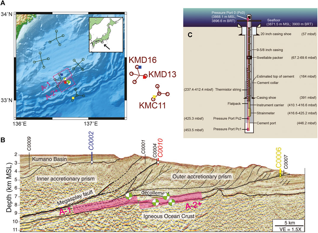
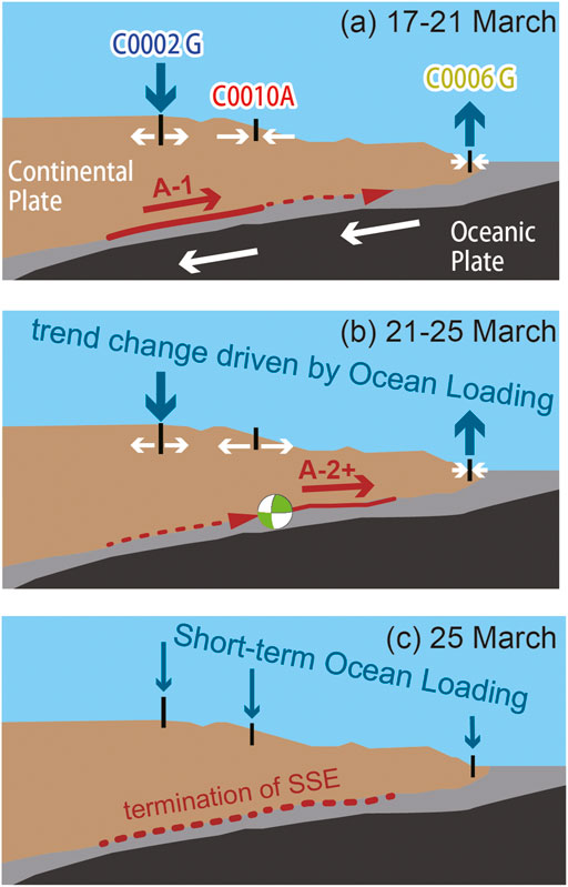
In the original article, there were mistakes in Figure 1B and Figure 13. In these figures, there were wrong focal mechanisms of VLFE, which contradicted with those in Figure 1A. The corrected Figure 1B and Figure 13 appear below.

FIGURE 1. (A) Map of the fault model (A-1, A-2+) of the SSE and sVLFE in March 2020 from previous results (Ariyoshi et al., 2021). Squares represent borehole stations. Labeled names (D-16, D-13, and C-11) are the nearby DONET stations for C0002 (blue), C0010 (red), and C0006 (yellow), respectively. Focal mechanism is obtained from Ariyoshi et al. (2021). (B) Seismic section showing the location of the boreholes C0002 (937–980 mbsf), C0010 (610 mbsf), and C0006 (453.5 mbsf), where mbsf = meter below seafloor; VE = vertical exaggeration. The average source location errors of sVLFEs are 5 and 2 km for horizontal and vertical component, respectively (Nakano et al., 2018). Spatial resolution of focal depth and fixed dip angle for the SSE is 1 km and 6°, respectively (Ariyoshi et al., 2021). The focal depths of the fault models A-1 and A-2+ are assumed to be consistent with VLFE because it is practically difficult to determine the focal depth precisely from only the two volumetric strain data at boreholes (C0002 and C0010) by using the simplified green’s function. (C) Borehole completion diagram at C0006. The solid magenta ellipses indicate the pressure gauges, where the top one (Pc0) is a hydrostatic reference pressure sensor used to remove oceanographic signals, BRT = below rotary table, and MSL = mean sea level. Figures (B,C) are modified after Figure 1 of Araki et al. (2017) and Figure 2 of Kinoshita et al. (2018), respectively.

FIGURE 13. Schematic scenario of the possible process for the SSE with ocean loading (A) during model A-1, (B) during model A-2+, and (C) termination of the SSE. Representative focal mechanism of VLFE is obtained from Ariyoshi et al. (2021). Double arrows represent volumetric strain change due to crustal deformation driven by the SSE.
As an additional explanation for Figure 1B, “the focal depths of the fault models A-1 and A-2+ are assumed to be consistent with VLFE because it is practically difficult to determine the focal depth precisely from only the two volumetric strain data at boreholes (C0002 and C0010) by using the simplified green’s function.”
The authors apologize for these errors and state that they do not change the scientific conclusions of the article in any way. The original article has been updated.
Publisher’s Note
All claims expressed in this article are solely those of the authors and do not necessarily represent those of their affiliated organizations, or those of the publisher, the editors and the reviewers. Any product that may be evaluated in this article, or claim that may be made by its manufacturer, is not guaranteed or endorsed by the publisher.
References
Ariyoshi, K., Iinuma, T., Nakano, M., Kimura, T., Araki, E., Machida, Y., et al. (2021). Characteristics of Slow Slip Event in March 2020 Revealed from Borehole and DONET Observatories. Front. Earth Sci. 8, 600793. doi:10.3389/feart.2020.600793
Nakano, M., Hori, T., Araki, E., Kodaira, S., and Ide, S. (2018). Shallow Very-Low-Frequency Earthquakes Accompany Slow Slip Events in the Nankai Subduction Zone. Nat. Commun. 9, 984. doi:10.1038/s41467-018-03431-5
Kinoshita, M., Becker, K., Toczko, S., Edgington, J., Kimura, T., Machida, Y., et al. (2018). “Expedition 380 Methods,” in The Expedition 380 Scientists, NanTroSEIZE Stage 3: Frontal Thrust Long-Term Borehole Monitoring System (LTBMS). Proceedings of the International Ocean Discovery Program. Editors K. Becker, M. Kinoshita, and S. Toczko (College Station, TX: International Ocean Discovery Program), 380. doi:10.14379/iodp.proc.380.102.2018
Keywords: slow slip event, slow earthquake, kuroshio meander, nankai trough, ocean modeling
Citation: Ariyoshi K, Kimura T, Miyazawa Y, Varlamov S, Iinuma T, Nagano A, Gomberg J, Araki E, Miyama T, Sueki K, Yada S, Hori T, Takahashi N and Kodaira S (2021) Corrigendum: Precise Monitoring of Pore Pressure at Boreholes Around Nankai Trough Toward Early Detecting Crustal Deformation. Front. Earth Sci. 9:770719. doi: 10.3389/feart.2021.770719
Received: 04 September 2021; Accepted: 16 September 2021;
Published: 30 September 2021.
Edited and reviewed by:
Sergey V. Samsonov, Department of Natural Resources, CanadaCopyright © 2021 Ariyoshi, Kimura, Miyazawa, Varlamov, Iinuma, Nagano, Gomberg, Araki, Miyama, Sueki, Yada, Hori, Takahashi and Kodaira. This is an open-access article distributed under the terms of the Creative Commons Attribution License (CC BY). The use, distribution or reproduction in other forums is permitted, provided the original author(s) and the copyright owner(s) are credited and that the original publication in this journal is cited, in accordance with accepted academic practice.
*Correspondence: Keisuke Ariyoshi, YXJpeW9zaGlAamFtc3RlYy5nby5qcA==
 Keisuke Ariyoshi
 Toshinori Kimura1
 Yasumasa Miyazawa
 Sergey Varlamov
 Takeshi Iinuma
 Akira Nagano
 Joan Gomberg
 Eiichiro Araki
 Toru Miyama
 Takane Hori
 Narumi Takahashi