
94% of researchers rate our articles as excellent or good
Learn more about the work of our research integrity team to safeguard the quality of each article we publish.
Find out more
REVIEW article
Front. Water, 04 March 2025
Sec. Water and Climate
Volume 7 - 2025 | https://doi.org/10.3389/frwa.2025.1553732
 Kiran Bala Behura1
 Sanjay Kumar Raul1Jagadish Chandra Paul1Sheelabhadra Mohanty2Prachi Pratyasha Jena1
 Sanat Kumar Dwibedi3
 Subhankar Ghosh4*Laishram Kanta Singh5*Sougrakpam Roma Devi6Arun Kumar Singha7Amulya Kumar Mohanty7
Evapotranspiration (ET) has considerable significance in the water cycle, especially in farming areas where it determines crop water needs, irrigation plans, and sustainable management of water resources. This study stresses the need for accurate ET estimation in paddy fields where rice is grown because of its high-water sensitivity and consumption which has implications for water use efficiency and food security. The study attempts to address the problem by estimating rice ET: Standard procedures such as the Penman–Monteith equation, lysimeters, and even remote sensing procedures such as Surface Energy Balance Algorithm for Land (SEBAL) and Mapping Evapotranspiration at High Resolution with Internalized Calibration (METRIC) are all investigated. Furthermore, an attempt is made to combine remote sensing data with machine learning techniques for refined ET estimation. Utilizing modernized technologies and hybrid models, the research investigation aims to deepen the understanding of ET variability for rice cropping systems to promote improved water resources management and sustainable agriculture practices as areas for future work suggest the application of vegetation indices incorporating high-resolution multi-spectral imagery to accurately estimate ET and appropriately differentiate between evaporation and transpiration in these complex agricultural systems.
Evapotranspiration is a vital component of the hydrological cycle, influencing crop water requirements, irrigation scheduling, and water resource management in agricultural landscapes (Wanniarachchi and Sarukkalige, 2022). Precise estimation of evapotranspiration (ET) is important for paddy fields due to rice's sensitivity to water availability and high-water consumption rate. Given the global reliance on rice as a staple food, understanding and estimating ET in paddy fields is essential to improve water use efficiency and contribute to sustainable agriculture (Bwire et al., 2024; Yang et al., 2021). Evapotranspiration (ET) is a key factor in paddy farming as it determines the water requirements that are vital for efficient water management which in turn affects agricultural outputs. The process in question combines plant ooze and evaporation from water and land surfaces making it integral in the context of agricultural water balance (Wanniarachchi and Sarukkalige, 2022). In paddy fields where efficient water use is a key factor, knowing the ET helps farmers to know the crop water requirements and optimize water use for irrigation to avoid drought in the fields. The estimation of ET is complicated by the spatial variation in vegetation, particularly in the periods of active change in the flux following precipitation and irrigation events (Wanniarachchi and Sarukkalige, 2022). In addition, employing technologies such as remote sensing and especially machine learning can boost the accuracy of ET assessments thereby making better management of water resources possible (Ghobadi and Kang, 2023; Alemohammad et al., 2017; Miralles et al., 2016). Since 39.0% of ET is accounted for by precipitation, which by itself creates additional water stocks, the dynamics of these water stocks and fluxes are important for ensuring balance in water use in paddy farming in a sustainable manner (Wanniarachchi and Sarukkalige, 2022).
Hydrological cycle and paddy fields interact at various growth stages and are relative to one another in terms of growth and yield of the plant. This interplay is pronounced in the case of conventional flood irrigation (CFI), in which root systems are developed in such a way that it does not penetrate deep soils (Arif et al., 2022). On the other hand, under the deficiency of water, for instance, in the System of Rice Intensification (SRI), this vertical growth of rice roots in the soil is favored. This adaptation leads to better nutrient acquisition and overall improved plant growth than any of the old planting systems that lead to roots developing at greater depth. The deeper root system helps the plant to withstand phases of paddy growth in which water stress may occur more frequently (Sarma et al., 2023). So, it can be observed that the water cycle and the growing of paddy are interlinked systems. Several environmental determinants are contributing to the water balance in the ecosystems of paddy fields, out of which the ET rates are highly affected (Kamruzzaman et al., 2020). In the context of evapotranspiration, the soil moisture content is the most significant factor as it limits water that may be evaporated or transpired by plants (Allen et al., 1998; Baldocchi and Xu, 2007).
Rice, one of the most water-intensive crops, must be continuously submerged to obtain maximum yields. Paddy cultivation requires great quantities of fresh water for its production in countries where rice is a major food and an important economic crop, such as India, China, Indonesia, and Thailand. Traditional rice cultivation involves flooding the fields for most of the growing season to reduce weed emergence, maintain a suitable microclimate, and keep pest populations low. Yet the resultant water demand exerts tremendous pressure on limited water resources, particularly in water-scarce areas facing conflicting demands for water due to climate variability, urbanization, and competing agricultural needs. But such a system needs a lot of water—roughly 2,500 liters for every kilogram of rice grown. These high-water requirements sustained throughout a rice-growing season place enormous demand on freshwater resources and can stress already scarce water resources in many situations.
Asian countries account for approximately 90% of the world's source of rice (Fukagawa and Ziska, 2019). As a result, the water needed for rice cultivation in these areas is enormous, frequently greater than the available water supplies, particularly in the dry season. ET is the total amount of water transferred from vegetation and soil surfaces to the atmosphere by transpiration and evaporation, respectively, and is the actual water used by the crop (Frevert et al., 1983). Understanding water use efficiency (WUE) is especially important because improving WUE maximizes productivity per unit of water lost, and precise estimates of ET are necessary for paddy systems to effectively schedule irrigation (Avila, 2015). Traditional irrigation methods for rice tend to be conservative and overpredict water needs, resulting in excessive losses by percolation and seepage. With ET-based irrigation, everything works much nicer: Farmers apply the amount of water the rice plants really need, making water management more sustainable (Bouman et al., 1994; Trinh, 2021). Good estimates of ET are also useful for determining crop-specific water demands at different growth stages in rice crops. For instance, the mid-season stage, characterized by abundant canopy coverage and high transpiration rates, is generally the most arduous time of the year regarding water needs (Smith et al., 1998).
In the context of paddy rice, evapotranspiration (ET) refers to the total water lost from a rice field through both transpiration by the rice plants and evaporation from the standing water and soil surface. This ET estimation technique is important for establishing the water demands of paddy fields, which are commonly flooded and form special environments that are different from non-flooded crops (Ikawa et al., 2017; Liu et al., 2018a,b; Kumari et al., 2022). Paddy fields are different from all the other crops because of their standing water, with varying footprints of the canopy stage, and because of the differences in regional climate factors (Lobell et al., 2009; Kamruzzaman et al., 2020). There are various key factors affecting actual ET in paddy fields.
The long periods of flooding in paddy fields cause the soil surface to be covered with the water level, which can lead to the formation of a layer of standing water that will be another hotbed of evaporation (Yan and Oue, 2011). This open-water evaporation is different from the soil evaporation in non-flooded crops where the sunshine and atmospheric conditions are directly onto the water; hence, the evaporation in paddy fields could be much larger in a hot and arid environment (Bwire et al., 2024; Penman, 1948). This open-water evaporation is separated from the plant transpiration but is still a significant part of the total ET; therefore, the ET in the paddy field is inherently larger than that in the non-flooded crops. After all, there are various stages of the paddy life cycle, and over it, the water requirements and a changing canopy shape both have direct relationships with ET rates (Jiang et al., 2023). The canopy is sparse in the early years of growth, resulting in higher direct evaporation from the surfaces of water and soil (Jiang et al., 2023; Liu et al., 2020; Ukpoju et al., 2023). Canopy cover increases as the crop matures, so that less water evaporates from the water surface, but transpiration from the plants increases as plants take up more water (Yan and Oue, 2011; Wei et al., 2015). Since ET is maximal at the flowering stage, due to the denser plant canopy and maximum transpiration rates (Cruz and O'toole, 1984), changes in canopy structure through the growing season result in high temporal variability of ET (Barnard Bauerle, 2016). In the context of the paddy field, climate factors such as humidity, temperature, wind speed, and solar radiation are considered to have a significant impact on ET rates (Lage et al., 2003; Kim and Kang, 2024). High temperatures and solar radiation can increase evaporation from standing water and transpiration from plants in tropical and subtropical regions where most of the world's rice is produced (YiMin et al., 2020). Seasonal monsoon rains also affect the possible water availability, consequently, the ET (Liu et al., 2018a,b; Yan et al., 2022).
Water loss through evaporation and plant transpiration (evapotranspiration) in rice farming changes a lot during different growth periods (Djaman et al., 2019a,b; Chen et al., 2023). Young rice plants have small leaves, so they do not release much water (Maina et al., 2014), but farmers flood the fields to stop weeds and create a good environment for the seedlings (Johnson, 1996). This standing water adds a lot to evaporation, which makes up most of the evapotranspiration at this early stage (Bouman et al., 2007; Johnson, 1996). For the tillering stage, water loss through evaporation and plant transpiration (evapotranspiration) in rice farming changes a lot during different growth periods (Abdullahi et al., 2013; Djaman et al., 2019a,b). To manage water, farmers need to understand these changes. This knowledge helps them to improve irrigation and reduce waste. First, in the planting stage, when farmers grow rice crops, evapotranspiration remains low (Abdullahi et al., 2013).
Then in the flowering stage, rice plants hit their bloom phase, that is, when they suck up the most water in the fields (Yang et al., 2019; He et al., 2020). Plants grow this thick leaf that hides the water underneath, making them lose all the leaves they have got. Even though the water does not evaporate as much because the leaves are blocking the sun, the total water use stays sky-high since the rice needs a lot of water when it is trying to make seeds (Zhang et al., 2007). Finally, rice plants get close to harvest time in the harvesting stage, and their evapotranspiration, or ET, goes down a lot. Paddy fields are dried out to help with the harvest, and because of that, there is less water for evaporation and loss of water through the plants (Covay et al., 1992). As the plants begin to get old and wither, their leaves start to shrink, and then, they do not transpire as much. This means the amount of water the air sucks up is the tiniest since they started growing (Lv et al., 2024; Kobayashi et al., 2013).
Weather conditions, such as how hot or cold it is, how much water is in the air, how fast the wind's blowing, and how much sun is beaming down, matter for how much water gets evaporated out of rice fields, which is called evapotranspiration (ET). The temperature influences ET (Allen et al., 1998; Snyder et al., 2013; Dai et al., 2022). When it gets hotter, the gap in vapor pressure between the water's surface or the rice plant's leaves and the nearby air gets bigger. Bigger ET numbers in hot spots where rice grows a bunch, but when it is chillier, ET figures tend to go down. This means places might not need as much water when it is not so hot out. Moisture in the air, which we call humidity, goes the opposite way of ET (Djaman et al., 2019a,b). When there is lots of humidity, the air is almost full up, which makes it harder for water to evaporate. This slows down how fast water and plants release moisture, making ET dive. But if it is not as humid, the air can take more water, speeding up ET for both water bodies and rice crops. Even if the heat is the same, ET may be lower in humid and hot areas than in dry, parched areas.
Wind speed is super important because it gets rid of that wet air layer hanging right above water and leaves (Shapira et al., 2024; Davarzani et al., 2014). When it is windy, there is more of that misty air swapping with dry air, which makes stuff dry up quicker because of all the evaporation and transpiration from plants. It was observed that in the paddy fields with the wind blowing, it was observed that more water evaporated when the weather was hot and the air was exceptionally dry, but if it is just a light breeze or pretty much still, that water vapor is not going anywhere fast, which means less water's disappearing into thin air (Allen et al., 1998; Skidmore et al., 1969). The main power behind ET in rice fields full of water is sunshine, because the water just soaks up those sunbeams, kicking up the amount of evaporation (Yoshida, 1979). When the sun cranks up its shine, there is more affinity to turn water into mist, and both evaporation and transpiration rates go up (Ikawa et al., 2017). As the rice gets taller and the leaves spread out, the sun's rays are more about transpiration since those plants are all involved in photosynthesis (Vishwakarma et al., 2023; Burgess et al., 2017). When it is cloudy or raining heavily during monsoon season, ET might take a hit with less energy coming in, but when the sky is clear, ET is on the rise (Hong et al., 2020; Ruosteenoja and Räisänen, 2013).
Evapotranspiration (ET) rates in rice fields are affected not only by the weather but also by things related to how the fields are managed and the type of soil, such as water levels, soil characteristics, and drainage (Arif et al., 2022, 2020). These elements work together to determine how water is kept, used, and lost from the field, which is important for good irrigation practices. The amount and depth of water level in rice fields have a big impact on ET rates (Arif et al., 2022; Liu et al., 2023). Fields with more water usually have higher evaporation from the surface. This is especially true in the early growth stages when there is less canopy cover, leaving more water exposed to sunlight and air (Suzuki et al., 2013). Later, when plants grow more, the canopy covers some water, but deeper water levels can still help increase soil moisture and ET through what plants take up. Keeping the water levels lower can help cut down on evaporation without harming the plants, thus conserving water (Bwire et al., 2024; Arouna et al., 2023; Amin et al., 2011).
Soil type is key in affecting ET because it influences how much water the soil can hold, how easily water moves through it, and how water rises in the soil (Zhao Y. et al., 2023; Li et al., 2014). In rice farming, soils with a lot of clay are common because they hold water well and do not let it drain quickly, which keeps standing water (Khanh et al., 2024). Soils with high clay content can slow down water drainage, allowing more water to be available for evaporation and transpiration, which increases ET (Tsiampousi, 2023; Krisdianto et al., 2023). On the other hand, sandy soils have fast drainage, needing more regular watering to keep water levels up and raising the chance of losing water (Linderman et al., 1976; Christen et al., 2006). Drainage systems are used in paddy fields to control water levels, prevent excessive waterlogging, and manage soil aeration (Negishi, 1970; Arif et al., 2020). Well-designed drainage systems allow excess water to be removed at specific crop growth stages, especially during the ripening phase when lower water levels are required (Matsue et al., 2021). Proper drainage can decrease ET by reducing the standing water available for evaporation, particularly during cooler parts of the season when drainage can also mitigate disease risks associated with waterlogged conditions (Yu et al., 2021). Conversely, poor drainage systems lead to excessive water retention, which increases open-water evaporation and soil surface evaporation (Darzi-Naftchali and Shahnazari, 2014).
The adoption of the Penman–Monteith method is functional and widespread, whereby it is seen as the benchmark for the estimation of ETs (Allen et al., 1998). The Penman–Monteith method combines energy balance and mass transfer methods (Penman, 1948; Monteith, 1965). The evapotranspiration rate is represented by the latent heat flux: The method integrates climatic variables such as temperature, wind speed, humidity, and solar radiation to estimate ET. The Blaney–Criddle (Doorenbos et al., 1977) and Hargreaves and Samani (Allen et al., 1998) methods are classified as empirical because they are easy to use and utilize less data input, which makes them ideal in regions where data are less available (Sobrinho et al., 2020). Lysimeters determine the reliable actual ET from the soil–plant system by measuring variations from the initial water volume contained in the soil (Fisher, 2012). This method may be very suitable for the validation and calibration of other models as it is possible to acquire highly accurate ET data (Ragheb et al., 2015; Fenner et al., 2019). The cost of installing and maintaining lysimeters is quite high (Fisher, 2012).
Also, at times it may miss out on larger field scales of variability in paddy systems (Shahrajabian and Sun, 2024). In addition to this, they do not separate evaporation from transpiration and therefore have limited use in trying to appraise the flooded rice fields' ET characteristics. These models estimate ET using a water balance approach in which soil moisture is evaluated over time, taking into account rainfall, irrigation, percolation, and runoff (Westenbroek et al., 2018; Andales et al., 2011). They may be transformed into paddy fields by incorporating parameters for percolation and seepage, which are typical in flooded systems. These models are data intensive as they require a lot of soil moisture and hydraulic data, which is not easy to gather in paddy fields because of the standing water (Bhadra et al., 2013). Remote sensing techniques, such as the SEBAL model and the METRIC model, utilize vegetation indexes and land surface temperature to determine ET over large areas (Wang et al., 2014; Pareeth and Karimi, 2023; Shamloo et al., 2021; Allen et al., 2007; Morse et al., 2004). These techniques provide means of ET assessment at several growth stages.
Remote sensing models, inside the emergent layer, require rigorous calibration and can be limited due to cloud interference, over the rice-growing season (Sah et al., 2024; Yuan et al., 2021). They might also struggle to deal with the field scale heterogeneities that pervade the paddy fields and waterlogged soils (Ferreira et al., 2023; de Lima, 2021). This approach measures the water vapor and heat fluxes interchange directly between the field surface and the air in a bottom-up method and can estimate ET on an instantaneous basis (Ha et al., 2014; Denager et al., 2020). It yields high precision and near-continuous ET estimates that also make it easy to track ET parameters on a seasonal or daily pattern basis for rice areas (Hossen et al., 2012; Chatterjee et al., 2021). Eddy covariance systems are costly and are inherently complicated and have high requirements on equipment and expertise (Ferrara et al., 2021). In addition, they are not applicable for high spatial scales appropriate for many Asian cultures of paddy (Zhao Y. et al., 2023).
Lysimeters are among the most reliable methods for directly measuring evapotranspiration (ET) as they simulate natural field conditions while allowing for precise water supply balance appraisal (Allen et al., 1998; Yang et al., 2000; Shahrajabian and Sun, 2024; Sagar et al., 2022). Moreover, they are labor-intensive and necessitate constipated sustenance, standardization, and data point recording, which bestow operating complexity in extended and remote study localization (López-Urrea et al., 2021; Shukla et al., 2006). To boot, multiple lysimeters may be necessary to seize spatial variability accurately across large paddy fields, far increasing both costs and trade union movement demands (Rana and Katerji, 2000). Lysimeters are widely used to measure evapotranspiration (ET) directly by going after the pee balance in a controlled soil volume that mimics field stipulation (Bryla et al., 2010; Sagar et al., 2022; López-Urrea et al., 2021).
Common methods for estimating evapotranspiration (ET) include the Penman–Monteith and Hargreaves-Samani equation, each with particular strong suits and restrictions in their respective harvest and climate context of use (Allen et al., 1998; Moratiel et al., 2019). The Penman–Monteith method is believed to be the stock advance for ET ideas as it mixes multiple climatic components, including solar radiation, air temperature, humidity, and the number of nothingness, making it extremely reliable under diverse agricultural conditions (Allen et al., 1998; Howell and Evett, 2004; Hao et al., 2018; Raoufi and Beighley, 2017; Varga-Haszonits et al., 2022). However, in paddy fields, where the filth is endlessly swampy, the Penman–Monteith model can bump difficulties as it assumes unsaturated status, implying that the water-saturated environment needs site-specific calibration to render accurate ET values (Jensen et al., 1990; Facchi et al., 2013; Saggi and Jain, 2022). Moreover, the Penman–Monteith equation relies on wide meteorological data, which may be challenging to receive in remote or resource-limited areas where paddy fields are often placed (Jensen et al., 1990).
The Hargreaves-Samani equation, on the other hand, is an empirical model that requires only temperature and extra-terrestrial radiation data to arrive at it utilitarian in data-scarce parts (Hargreaves and Samani, 1985). While its simplicity enables broader applicability, the Hargreaves-Samani method lacks sensitivity to important environmental divisors such as humidity and wind, which are critical in the unique microclimate of swamp paddy study (Hargreaves and Samani, 1985). As a result, the ET estimate derived from the Hargreaves-Samani model may be inaccurate for paddy fields, frequently ask for empirical adjustments to improve alignment with the specific water and vapor exchange moral force of rice culture (Xu and Singh, 2002).
Irrigation records, which get across the amount and frequency of water applied to fields, can sometimes be expended to indirectly estimate evapotranspiration (ET) by assuming that the primary water exit from the study is due to ET (Allen et al., 1998; Wanniarachchi and Sarukkalige, 2022; Bochetti et al., 2016). This advance is in particular useful in data-scarce environments, where direct ET measurements are unavailable, and it can provide an approximate discernment of water requirements (Ghiat et al., 2021; Cutting et al., 2024; Bochetti et al., 2016). All the same, one limitation of using irrigation records for ET estimation is that these disks do not describe other components of the piddle equalizer, such as soil moisture change, runoff, and deep percolation, which can vary considerably based on subject area shape and soil eccentricity (Seckler et al., 2003; Li et al., 2019; Bethune et al., 2008; Schulz and Becker, 2021). To boot, the efficiency of irrigation practices affects the accuracy of ET approximation; for lessons, losses due to vaporization, outflow, or mismatched body of water distribution mean that not all implemented water is used by the harvest (Kisekka et al., 2019; Irmak et al., 2011). In paddy areas, the presence of standing water further perplexes the relationship between irrigation and ET, as vaporization from the water control surface may not reflect crop economic consumption accurately, leading to potential overestimation or underestimation of actual ET (Bouman et al., 2007; Satpathi et al., 2024). Due to these factors, ET estimates based solely on irrigation records lack precision; progressing to them to a lesser extent is more authentic than methods that directly evaluate or model ET with greater detail in environmental input (Allen et al., 1998; Pinos, 2022). A detailed information about different ET estimation methods is given in the flowchart below (Figure 1).
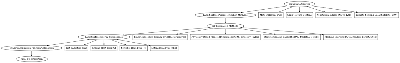
Figure 1. Flowchart for evapotranspiration estimation methods in paddy fields.
New studies are combining remote sensing data with machine learning algorithms to enhance ET estimation (Costa et al., 2023; Chatterjee et al., 2023). They are data-driven, and machine learning models can learn from large datasets to abstract complicated patterns and relationships, which can potentially increase the estimation accuracy of the ET in all paddy field conditions (Gokool et al., 2024; Onojeghuo et al., 2018). IoT sensors, such as soil moisture, temperature, and water level sensors, are more frequently used to collect field data in real time (Garg et al., 2021; Binayao et al., 2024). These sensors provide a more holistic insight into the dynamics of paddy field water when integrated and help facilitate remote sensing data and hydrological models (Alahmad et al., 2023; Wattanapanich et al., 2024; Chiaradia et al., 2015). Future research is focusing on developing ET models specifically designed for flooded rice systems (Facchi et al., 2013; Xu et al., 2023). These models consider unique factors such as water depth, canopy dynamics, and seasonal water demand fluctuations to improve ET estimation accuracy (Adhikary et al., 2024; Nay-Htoon et al., 2018; Timm et al., 2014).
Satellite-free base and airborne sensing technology have significantly enhanced evapotranspiration (ET) estimates by providing large-exfoliation, uninterrupted data points that improve both accuracy and scalability (Allen et al., 2007; Pareeth and Karimi, 2023; Wasti, 2020; Peddinti et al., 2024). These technologies allow for the collection of spectral and multi-spectral imagery, which is employed to calculate vegetation indices and landed estate surface temperatures—key parameters for estimating ET expend surface energy balance models (Bastiaanssen et al., 1998; García-Santos et al., 2022). Remote sensing-based models, such as the Surface Energy Balance Algorithm for Land (SEBAL) and Mapping Evapotranspiration at High Resolution with Internalized Calibration (METRIC), comprise these data to develop ET mapping over extensive agricultural fields, enhancing the spatial insurance coverage compared to traditional ground-based methods (Allen et al., 2007; Derardja et al., 2024; Saha et al., 2022). Estimation at different spatial and temporal resoluteness, satellite platforms such as Landsat, MODIS, and Sentinel provide frequent observance of appropriate seasonal declination in water utilization, which is essential for dynamic water resource management (Senay et al., 2016; Rashid and Tian, 2024; Singh et al., 2020). The capability is especially valuable in regions with limited primary data or outside areas where ET measurement is logistically challenging and expensive (Tang et al., 2017; Li et al., 2009; Cutting et al., 2024; Derardja et al., 2024). Yet, challenges such as cloud cover, in particular in tropic regions, can occasionally limit data point availability from satellites, although improvements in datum optical fusion and cloud-removal techniques are helping to mitigate these publications (Gao et al., 2017; Meraner et al., 2020; Prudente et al., 2020; Chen S. et al., 2022).
Surface Energy Balance Algorithm for Land (SEBAL) is a wide-habitat remote sensing-based model for estimating actual evapotranspiration (ETa) by examining the surface energy balance over land surfaces, making it suitable for agricultural water management applications (Wei et al., 2022; Bastiaanssen et al., 2005). This method uses satellite data to calculate ETa by evaluating get-up-and-go substitution between the soil surface and atmosphere (Bastiaanssen et al., 1998; Shamloo et al., 2021). Paddy fields are qualified by a high-pitched arc degree of wetness, and SEBAL can capture this by assessing the latent heat flux, which is the energy expended for evapotranspiration. SEBAL counts ETa by using parameters such as net radioactivity, soil heat flux, and temperature deviation, which are in particular similar to waterlogged precondition typical in paddy fields (Teixeira et al., 2009; Wei et al., 2022). SEBAL uses satellite imagery, enabling spatially continuous ETa appraisal over extensive areas, which is valuable for monitoring water use across paddy fields at the regional scale (Bastiaanssen et al., 2005). Unlike traditional method acting, SEBAL does not rely heavily on in situ meteorological data as it uses infrared data to estimate temperature and ETa directly, making it efficient in data-scarce regions (Pareeth and Karimi, 2023). SEBAL requires clear skies for accurate thermal infrared data acquisition, which can be challenging during the monsoon season in the paddy-uprise part, leading to data gaps (Sun L. et al., 2017; Long and Singh, 2010). The status for the partition may not be checked in all scenarios, such as assuming uniform vegetation cover, which can touch on ETa accuracy, particularly in heterogeneous or mixed cropping landscapes (Tasumi et al., 2008; Taheri et al., 2022; Yang et al., 2015). The solution of satellite data used in SEBAL may not be appropriate for finer field-level variations in water utilization within paddy fields, potentially hampering its application program for precision agriculture (Allen et al., 2007; Sishodia et al., 2020). These strengths and limits guide the application program of surface energy models for estimating ET in paddy fields, where frequent monitoring and direction are crucial for crop productiveness and sustainability.
Mapping Evapotranspiration at High Resolution using Internalized Calibration (METRIC) is an outside-sensing-based model that estimates actual evapotranspiration (ETa) by aiming the airfoil energy balance wheel at a high spatial firmness of purpose, ideal for heterogeneous and water-intensive crops such as rice paddy. The model refines energy balance calculations through internalized calibration, enhancing accuracy for localized ET estimates (Allen et al., 2007; De la Fuente-Sáiz et al., 2017; Madugundu et al., 2017). By desegregating reason-ground condition data with thermal infrared satellite imagery, METRIC effectively assesses ETa across fields with high spatial detail, which is crucial for precise management in these fields (Irmak et al., 2011; Derardja et al., 2024). METRIC provides high-resolution ET functions that can spot between case-by-case paddy patches, enable direct irrigation practice sessions, and improve water use efficiency (Chandel et al., 2021; Biggs et al., 2016). METRIC leverages localized weather conditions and ground data for interior calibration, minimizing misplay in ET estimation, and making it adaptable to different neighborhoods and crop types, such as water-intensive paddy fields (Gonzalez-Dugo et al., 2009; Ortega-Salazar et al., 2021; De la Fuente-Sáiz et al., 2017). METRIC can sire multiple ETs to function over a single farm season, which allows monitoring of paddy water indigence and growth stages, enhancing crop management efficiency (Allen R. et al., 2011). It requires local weather data, including solar irradiation and wind speed, for exact calibration. This dependence on soil data can be a limitation in regions with limited data availability, which may affect truth in certain paddy field-originating areas (Hankerson et al., 2012; Khan et al., 2018). METRIC's reliance on cloud-free orbital imagery, especially for thermal striation, may result in data gaps during monsoon or cloudy conditions, a common issue in paddy regions (Singha and Kamruzzaman, 2019; Jiang et al., 2021). METRIC's complex internal calibration mental process can require significant computational resources, which may be challenging for large-weighing machine applications without tolerable processing infrastructure.
Simplified Surface Energy Balance Operational Model (SSEBop) is a simplified surface proportion model that estimates literal evapotranspiration (ETa) by commingling land airfoil temperature data points with minimal auxiliary data, making it highly efficient for large-ordered series applications (Pareeth and Karimi, 2023). Unlike former ET models, SSEBop calls for entirely a few stimulations, such as land surface temperature and acknowledgment of ET data, simplifying its habit in areas where meteorological data are sparse, a vernacular scenario in remote paddy regions (Senay et al., 2016; Yin et al., 2020). SSEBop's simplified algorithm enables faster processing, which is critical for large-scale monitoring. It can engender high-frequency ET maps over magnanimous paddy cultivation areas, aiding in regional water management and crop monitoring. SSEBop can be applied across assorted weighing machines, from regional to continental levels, allowing agricultural agencies to supervise usage in the field consistently, regardless of area size (Zhuang et al., 2022). SSEBop uses generalized assumptions for free energy balance that may not capture the complex hydrology of flooded rice paddy fields as accurately as other detailed ET frameworks, potentially affecting ETa precision (Yin et al., 2020; McShane et al., 2017). Like near-remote sensing models, SSEBop relies on clear-sky satellite images for land surface temperature data, which can be a challenge in monsoon regions, potentially leading to ETa data gaps (Senay et al., 2016; Tawalbeh et al., 2024). Overall, SSEBop's reduced datum and computational requirements make it a pragmatic alternative for large-scale paddy monitoring, maintaining sustainable water supply direction in rice cultivation.
Mokhtari et al. (2011) conducted a study that estimated ET over a pistachio orchard using the SEBAL and METRIC models with Landsat TM5 data. The results showed that the two models estimated similar ET at the time of the satellite overpass but differed at the daily level, especially when ET rates were higher. These differences were attributed to variations in the calculation of sensible heat flux and the methods each model employs to extrapolate instantaneous ET to daily values. Notably, SEBAL's advantage lies in its minimal requirement for ground-based weather data, whereas METRIC, though necessitating high-quality local weather data, accounts for daily climatic variability through the use of reference ET, making it more suitable in environments with fluctuating daily weather conditions.
Research that compared the SEBAL and METRIC models under various field conditions, including flooded and non-flooded areas, established that ET was estimated correctly by both models, but differences in their performance occurred under specific environmental conditions. In the case of floodwater in open fields, these assumptions and parameterizations of models have affected their accuracy in computing ET (Thoreson et al., 2009). Model selection based on field conditions thus becomes important in this regard. More recent efforts have been to evaluate SEBAL and METRIC for their viability in precision agriculture. Such studies therefore emphasize the fact that, before selecting and applying these models to estimate ET, local environmental conditions such as soil moisture levels and vegetation cover have to be taken into consideration.
Paddy fields are frequently waterlogged, especially during growth stages, which alters reflectance patterns in remote sensing-based ET exemplars (Gan et al., 2021; Wei J. et al., 2023). The standing water makes high reflectance, particularly in the visible and near-infrared circle, making it challenging to differentiate between water and vegetation accurately (Wei J. et al., 2023; Carracelas et al., 2024). This can affect ET estimates as role models may misread water bodies (Carracelas et al., 2024; Ferreira et al., 2023). ET models such as SEBAL and METRIC take calibration to match specific characteristics, which is especially important in paddy fields due to their unparalleled water–soil–flora interaction (Wei et al., 2022). Harvest-specific parameters, such as albedo and emissivity, need deliberate adjustment to capture the effects of swamp grime and heavy canopy accurately. Without these accommodations, model yield may not reflect the actual ET patterns of paddy fields (Bastiaanssen et al., 1998; Bashir et al., 2008; Sun L. et al., 2017). These parameters for paddy rice are all important to answer the unique dynamics and water use pattern of flooded rice culture. Paddy fields' water orbitally influences temperature and reflection factors (Liu et al., 2019). The surface typically maintains a low temperature compared to dry stain, which impacts the thermal infrared signal utilized in many ET models (García-Santos et al., 2022; Mallick et al., 2018). Water supply speculates sunlight differently compared to land or vegetation, which can modify the airfoil albedo value utilized in ET deliberation, leading to inaccurate ET estimates if not addressed properly (Ponce et al., 1997; Hannabas, 1989). These water supply-link impressions are essential for precise ET modeling in the paddy area, where dynamic H2O floors are rife throughout the growing time of the year (Xu et al., 2023; Adhikary et al., 2024). These unparalleled preconditions in the paddy field require measured considerateness in the ET role model, with specific alterations for water reflectance, crop-specific calibration, and the cool-down upshot of water on surface temperature.
Artificial satellite data points from rootage, such as Landsat and Sentinel, play a critical role in accurately estimating ET in paddy fields, where water distribution and crop conditions vary at minuscule scales (Singh et al., 2020; Xue et al., 2021). These satellites provide finer spatial resolution (10–30 m), enabling precise identification of individual paddy fields, which is substantive for understanding localized ET variability (Allen R. G. et al., 2011). High-resolving imagery assists in discerning between plots with tolerable water, unseasoned seedlings, and mature crops, improving ET accuracy by admitting ET models to account for these distinct stages and their unequaled water system demands (Imtiaz et al., 2023; Fernández-Urrutia et al., 2023; Ramadhani et al., 2020). For paddy cultivation, where plot sizes are frequently humble, the high spatial answer of satellites such as Landsat and Sentinel is peculiarly good (Waleed et al., 2022; Park et al., 2018). This declaration helps one monitor intra-field heterogeneity in moisture and flora and moderate more exact ET estimates across paddy plots (Bai et al., 2019; Mengen et al., 2023). Fine spatial data enhance the dependability of ET modeling by minimizing the “mixed pixel” force, which occurs when harsh firmness of purpose imagination averages conditions over a field, potentially missing small exfoliation variations typical of paddy fields (Cammalleri et al., 2013; Liou and Kar, 2014; Zhang et al., 2024a,b).
Although high-resolution satellites declare themselves spatially detailed, they typically let retentive revisit times, which can limit their ability to detect rapid changes in ETa, particularly during decisive paddy growth form or seasonal changeover (Xue et al., 2021; Anderson et al., 2021). This craft-off between spatial and temporal resolution frequently necessitates a balance between precision and relative frequency, where temperate-settlement satellites with more frequent overpasses, such as MODIS, might be desegregated for continuous ET monitoring at a coarser graduated scale (Cenci et al., 2018; Bair et al., 2023). However, advancements in high-resoluteness artificial satellite constellations, such as Sentinel-2′s five 25-h revisit period, help accost this limitation and hit high-absolute frequency and high-pitched-resolution ET, which supervises progressively viable (Drusch et al., 2012; Guzinski et al., 2020). To mitigate the trade-off, many researchers practice datum fusion proficiency that conflates high-resolution data with frequent, modest-resolution data points (Cammalleri et al., 2013; Guzinski et al., 2020). This approach provides both spatial particularity and worldly continuity, taking to more robust and timely ET approximation. Data fusion raises the potency of the ET model by maintaining spatial precision while accommodating temporal variety in crop emergence and water use (Cammalleri et al., 2013; Wang et al., 2019).
TerraClimate is a global dataset that provides monthly climate and water balance variables at a spatial resolution of about 4 km, covering the period from 1958 to 2018. It integrates high-spatial-resolution climatological data with coarser-resolution time-varying data to offer detailed insights into climatic conditions. This dataset is especially useful for regional climate assessments and hydrological studies (Solaimani and Ahmadi, 2024). ERA5 is a comprehensive reanalysis dataset developed by the European Center for Medium-Range Weather Forecasts (ECMWF), which provides hourly estimates of various atmospheric, land, and oceanic variables at a horizontal resolution of 31 km, covering the period from 1979 to the present (Muñoz-Sabater et al., 2021). ERA5-Land is a complementary dataset that focuses on land variables, with enhanced spatial resolution at 9 km. Both datasets are significant for climate monitoring, weather forecasting, and hydrological modeling. GLDAS combines satellite and ground-based observation data with more advanced land surface modeling techniques for generating optimal fields of land surface states and fluxes (Rodell et al., 2004). GLDAS has global high resolution at the finest of 1 km to the coarsest of 2.5 degrees. Therefore, it could provide information in terms of the variables of soil moisture, surface temperature, ET, etc. GLDAS is widely used for drought monitoring, water resource assessments, and climate studies. GLEAM is a satellite-based model dedicated to estimating terrestrial evaporation and root-zone soil moisture globally (Miralles et al., 2011). It operates at a daily time step with a spatial resolution of 0.25 degrees (Martens et al., 2017) and uses various satellite observations to provide detailed estimates of ET components, including transpiration, soil evaporation, and interception loss. GLEAM is useful in ecological studies, drought monitoring, and climate research.
Machine learning (ML) models are sinewy tools for estimating ET in paddy fields of honor as they can seize complex, non-linear relationships among meteorological data (for instance, temperature, humidity, and wind speed), remote sensing data, and field observation (Noghankar et al., 2023; Costa et al., 2023). Unlike traditional models, ML algorithmic rules can analyze vast and various datasets to learn the underlying convention in these variables and run to a greater extent accurate ET prediction (Kamble et al., 2013). ML models, particularly those grounded in deep learning, can handle high-dimensional remote smell data from generators such as Landsat and Sentinel, along with meteorological input signals, to provide continuous ET ideas for paddy fields (Xu et al., 2021; Waleed et al., 2022). By analyzing both spatial and worldly data, these models appropriate seasonal and harvest-specific mutants in ET, enabling exact monitoring of water employment throughout the paddy field (Rong et al., 2024). Machine learning examples, such as random forests and support vector machines, have progressed in mechanisms for feature article extraction, give up on them to name the most influential variable in ET estimates from extensive datasets (Ayaz et al., 2021; Sammen et al., 2023). In addition, ML models support datum fusion techniques, commingle meteorological datum, artificial satellite imaging, and field observations to account for both local environmental consideration and all-embracing climatic radiation patterns, leading to improved ET estimation accuracy (Cammalleri et al., 2013; Zhao et al., 2024).
Paddy fields often get dynamic shapes, such as fluctuating water degrees and rapid growth degrees (Ismail et al., 2012; Wang et al., 2024). ML models can be retrained or updated with new data to conform to these changing conditions, ensuring that ET appraisal is accurate over sentences. This adaptive electrical capacity ML model is to a greater extent suitable for long-term ET monitoring in paddy schemes under variable environmental conditions. In areas with modified fields of data, machine learning is a good example that can leverage remote sensing data as a proxy for field mensuration, effectively making a full data point (Reyes Rojas et al., 2021; Chatterjee et al., 2023). This flexibility is particularly beneficial in outside paddy field-developing regions, where in situ data point collection can be challenging (Ferreira et al., 2023; Satpathi et al., 2024). Machine learning models thus enhance ET estimation in paddy fields by leveraging diverse datasets and complex interactions among variables, leading to a greater extent of exact and adaptable ET predictions.
Linear regression (LR) is often used in evapotranspiration (ET) studies to model simple, analog relationships between ET and meteorological variables such as temperature, humidity, and solar radiation (Cristea et al., 2013; Jayashree et al., 2023). For instance, linear simple regression can foretell ET found on temperature trends in an area where ET exhibits a nearly analog response to temperature changes. This approach is square and computationally efficient, making it useful for ET estimates in paddy fields when the relationships are relatively wide-eyed. While elongate regression can bring home the bacon with initial estimates, it often falls short in paddy areas, where ET moral force is influenced by complex, non-linear interactions among agent-like vegetation cover and soil moisture (Aghelpour and Norooz-Valashedi, 2022). Paddy production involves multiple outgrowth stages and water management practices that involve modeling to capture the non-linear core (Wei et al., 2022; Anapalli et al., 2019).
Decision trees (DT) are in force in enamoring the non-linear relationships present in ET estimation, in particular in complex agricultural settings such as paddy fields. By dividing datum into subsets found on input signal lineament, decision trees can model interactions between variables such as temperature, vegetation parameters, and moisture (Jain and Gupta, 2024; Treder et al., 2023). This bodily structure enables them to address mixed effects, such as the influence of standing water on ET at different harvest microscope stages (Jain and Gupta, 2024; Bijlwan et al., 2024). Decision trees can incorporate both continuous (e.g., temperature and solar irradiation) and flat variables, making them extremely adaptable to the diverse data used in rice paddy ET modeling (Zhao L. et al., 2023; Hancock and Khoshgoftaar, 2020). This flexibility takes into account decision trees to simulate the influence of crop-specific consideration and irrigation drills on ET, improving ET estimation in paddy fields where different increase points give varying water requirements. Ensemble plans, such as random woods, compound multiple decision trees to improve prediction accuracy and validity in ET modeling (Agrawal et al., 2022). By aggregating results from multiple trees, the ensemble method reduces forecasting variability and captures good, complex, active ET design in the paddy arena, even under varying water and climatic status (Salahudin et al., 2023; Wu et al., 2021). In sum, linear regression allows a service line for bare ET molding, while decision trees and their ensemble variants capture the complex, non-linear relationship decisive for accurately figuring ET in paddy fields.
Artificial neural networks (ANNs) are particularly suited for estimating evapotranspiration (ET) in paddy fields due to their ability to model complex, non-linear family relationships among input variables (Amaratunga et al., 2020; Arif et al., 2013). The psyche's structure enables them to learn intricate dependencies between agents such as temperature, humidity, and vegetation indices that impact ET. This capability builds ANNs that are highly effective for ET models as paddy ET calculates on respective non-linear interactions. ANNs can easily desegregate both satellite-derived data, such as solid ground Earth's surface temperature and vegetation indices, with area-measured parametric quantities such as ground moisture and crop growth stage (Efremova et al., 2019; Kumar et al., 2011). On the heterogeneous datum, ANNs learn spatial and secular patterns in ET, readying them ideally for covering that involves mixing remote sensing data with reasoned truth observations to calculate ET in the paddy battlefield (Wang et al., 2018; Jeong et al., 2022). One of the merits of ANNs lies in their ability to automatically take out meaningful features from input data (Hemanth, 2021; Shaheen et al., 2016). For ET approximation, think of that ANNs can uncover subtle patterns between satellite imagery characteristics and orbit data, which may not be apparent using traditional statistical methods (Liu et al., 2021; Karahan et al., 2024). This potentiality is essential in paddy fields, where active water levels, crop covert variety, and seasonal variation bestow complex ET patterns. Paddy fields are characterized by phases of water inundation, ontogenesis, and harvest, all of which falsify ET (Ikawa et al., 2017; Chen et al., 2024). ANNs can adapt to these dynamic circumstances because they determine now from data, refining their parameters with each modern stimulant (Islam et al., 2024; Ger et al., 2024; Dai et al., 2013). This adaptability allows them to render accurate ET ideas throughout the integral growing season, accounting for sport in water levels and craw growth stages (Chowdhary and Shrivastava, 2010; Karahan et al., 2024; Laaboudi et al., 2012). ANNs, particularly cryptical neural nets, are capable of using high-declaration planet imagination to generate elaborated ET maps for rice paddy fields (Imtiaz et al., 2023). By learning from pixel-level data, ANNs provide fine-scale ET gauges that account for field-specific conditions, enabling more precise water resource direction and irrigation planning for Mick cultivation (Arif et al., 2013; Khan et al., 2020). Overall, ANNs are substantially suited for paddy ET approximation due to their capacity to capture complex, non-linear habituation, integrate diverse data authors, and adapt to switch conditions, leaving highly accurate ET predictions.
Support vector machines (SVMs) are widely applied in ET appraisal for paddy fields due to their ability to model complex, non-linear human relationships between comment characteristics such as temperature, solar radiation, and flora indicants (Yang et al., 2011; Ashrafzadeh et al., 2020; Guo et al., 2024). SVMs are especially beneficial for charm interaction among diverse variable stars in paddy study, where ET is regulated by water presence, harvest stage, and climatic conditions (Ashrafzadeh et al., 2020; Ayalew and Lohani, 2023). SVMs use a kernel map to map input data points into a gamey-dimensional quad, which allows them to capture non-linear colonies in ET data (Tejada et al., 2022; Wilimitis, 2018). SVMs are highly accurate in predicting ET for paddy fields, where the relationship between crop growth stages, water layer, and ET is far from linear. As a result, SVMs can provide more accurate ET estimates under varying field conditions (Guo et al., 2024). Random forests, an ensemble learning method based on decision trees, are especially robust in ET estimation because they aggregate predictions from multiple tree diagrams and contract prevision variants (Treder et al., 2023; Wu M. et al., 2020). This robustness makes random forests highly suitable for ET modeling in rice paddy fields, where environmental and crop status interchange often. By averaging results from various decision trees, random forest produces consistent ET estimates across diverse shapes (Dhillon et al., 2023; Wang et al., 2020). Random forests are, in effect, integrating high-dimensional data from multiple sources, such as satellite imagery, meteorological records, and soil moisture measurements (Clewley et al., 2017; Shokati et al., 2024). This flexibility allows them to sit ET accurately by capturing the influence of dissimilar data sources and adjusting to seasonal variation and spatial heterogeneity in paddy areas (Wang et al., 2020; Msangi, 2024). Both SVMs and random forests heighten ET idea truth and robustness in paddy plains by caring for complex data and adapting to various conditions. SVMs provide reliable foretelling by managing non-linear relationships, while random forest sums robustness through ensemble averaging (Son et al., 2018; Wang et al., 2020; Guo et al., 2024). In concert, these methods enable exact ET estimates across various growth levels, water levels, and climatic scenarios. In summary, SVMs and random forests proffer high accuracy and robustness in ET estimation for paddy plains and enable effective water management in various and dynamic agricultural conditions.
Many other machine learning (ML) methods apart from artificial neural networks (ANN), support vector machines (SVM), and random forests (RF) applied to evapotranspiration modeling include convolutional neural networks (CNNs). Their main strength is the ability to take in grid-based data, so they are useful for capturing spatial features in ET data. Long short-term memory networks are a subtype of recurrent neural networks and particularly perform well at the handling of temporal sequences that qualify them very much to time-series ET data. Gated Recurrent Units (GRUs), as an alternative to LSTMs but with a simplified architecture, have also been applied in ET modeling in addition to extracting long dependencies. A comparative analysis of such deep learning models indicated that hybrid models such as CNN-GRU can outperform their individual counterparts in the tasks of ET prediction (Paul et al., 2024). Levenberg–Marquardt (L-M) algorithm is the L-M model with a focus on neural networks and has been utilized in the application of ET estimation. Compared with the GA-BP model, it provides greater accuracy (Niu et al., 2023). The use of gradient boosting methods (GBM) combines weak predictive models into a strong predictor for enhanced prediction accuracy in ET (Ayaz et al., 2021). Random Vector Functional Link (RVFL) Networks, enhanced with metaheuristic algorithms such as the Quantum-based Avian Navigation Optimizer Algorithm (QANA) and Artificial Hummingbird Algorithm (AHA), have been applied to ET modeling, with encouraging results (Mostafa et al., 2023).
The application of the k-NN algorithm to the estimation of daily ET has demonstrated its feasibility and effectiveness in ET pattern capture (Yildirim et al., 2023). Multigene Genetic Programming (MGGP) has been applied to model ET, providing an adaptable approach to capturing complex data relationships (Yildirim et al., 2023). Relevance Vector Machines (RVMs) for ET modeling result in sparse solutions and probabilistic predictions, useful in some contexts (Mostafa et al., 2023). These ML approaches have some benefits over ET model formulation, that is, better accuracy enhanced treatment of non-linear relationships, and enhanced generalization ability. The choice of the method, however, depends upon several factors including the characteristics of the dataset, the availability of computational resources, and the balance among model complexity, interpretability, and associated problems. A brief overview about different ET estimation methods is provided in Table 1.
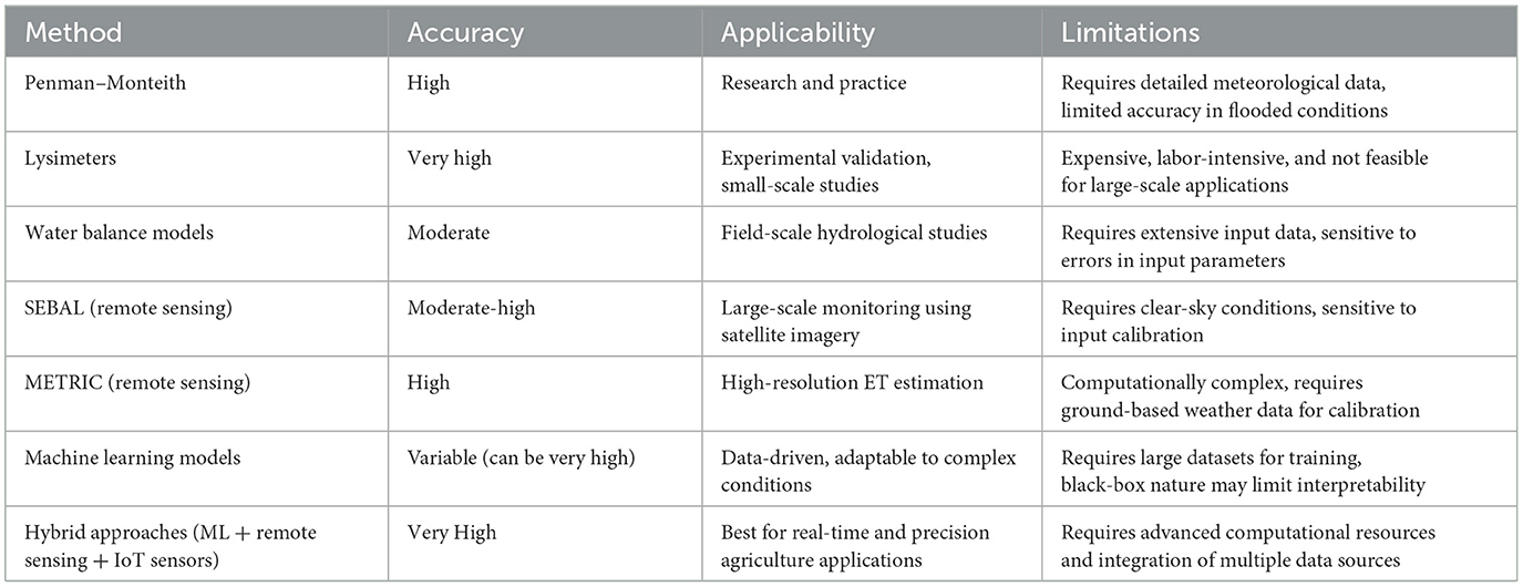
Table 1. Evapotranspiration estimation methods.
Studies comparing machine learning (ML) models for paddy ET estimation reveal that examples, such as support vector machines (SVMs), random forests (RFs), and artificial neural networks (ANNs), perform well in data-plentiful contexts (Sattari et al., 2021; Jain and Gupta, 2024; Granata, 2019). For example, studies show that ANNs, which can model complex non-linear family relationships, excel in capturing ET unevenness when put up with obtuse distant sensing and meteorological data points, leading to accurate results (Chen et al., 2013; Dimitriadou and Nikolakopoulos, 2022; Kumar et al., 2011). Random forests have been highlighted as especially strong in scene with greater dimensional and interracial data as they handle both uninterrupted and categorical variables (Fellinghauer et al., 2013). Cogitation reports that RF models outperform traditional statistical methods and yet some other ML models in ET ideas by integrating various data cases, such as satellite images, soil moisture records, and harvest phenology information. RF's ensemble approach adds lustiness to ET estimates in dynamic paddy environments (Yi et al., 2018; Wang et al., 2020; Shokati et al., 2024).
Support vector machines are noted for enhancing non-linear human relationships in ET estimation while resisting overfitting, even when the data are complex (Tejada et al., 2022; Guo et al., 2024). Relative studies argue that SVMs uphold high accuracy across different stages of paddy development and varying water levels, making them reliable for ET estimation in puddled rice fields. However, SVMs can be computationally intensive, especially with large datasets (Marsujitullah et al., 2019; Tsang et al., 2005). Despite their specialty, ML examples face limitations in data-scarce environments. Studies have found that while ANN and SVM models often require extensive training data points to avoid overfitting, they can struggle with special datasets, leading to shrinkage in truth in sparse data regions (Han and Jiang, 2014; Bilbao and Bilbao, 2017). Random forests run to perform slightly comfortably in data-scarce place settings due to their ensemble approach but may nonetheless underperform compared to data-rich scenarios (Sameen et al., 2019). Subjects have also highlighted that ML theoretical accounts for paddy ET estimation a great deal take crop-specific calibration to account for paddy field precondition, such as standing water and specific outgrowth stages (Arif et al., 2022). This demand for exact standardization can limit the all-inclusive pertinence of ML exemplars across different rice-growing regions unless extensive regional data are usable for role model adaptation (Mostafa et al., 2023). In summary, while ML models such as ANNs, RF, and SVMs have shown great promise for ET estimation in datum-rich paddy environments, their truth can decrease in data-scarce terms, and they often take careful calibration for crop-specific scenarios.
Combining the Surface Energy Balance (SEB) model, which utilizes energy flux measurements from satellite datum, with machine learning (ML) techniques can enhance evapotranspiration (ET) approximation for rice paddy fields (Wei et al., 2022; Du et al., 2013). SEB models, such as SEBAL and METRIC, leverage outback sensing datum to estimate ET and establish the muscularity balance at the land surface, capturing spatial variability effectively. ML models, on the other hand, can learn complex, non-linear relationships from various datasets, offering increased adaptability to active stipulation and enabling more exact ET prediction (Bastiaanssen et al., 2005; Allen R. et al., 2011; McShane et al., 2017; Treder et al., 2023). SEB models benefit from the high spatial answer of satellite imagery, allowing for detailed ET mapping (Pareeth and Karimi, 2023; Kiptala et al., 2013). Even so, they oftentimes lack the temporal declaration needed to capture daily or intra-seasonal variations in paddy areas. Integrating ML with SEB serves to bridge this gap by using historical and material-time data to falsify secular trends, thus achieving finer temporal resolution without relying solely on frequent satellite imagery (Bai et al., 2024).
SEB and ML model combinations provide complementary data desegregation strengths that ameliorate ET estimation accuracy. While SEB relies on satellite inputs such as land surface temperature and coefficient of reflection, ML modeling can incorporate extra stimulants such as meteoric datum, soil wetness, and harvest-specific data (Pareeth and Karimi, 2023; López-Urrea et al., 2021; McShane et al., 2017). Combining SEB outturn with ML models, such as random forests or artificial neural networks, helps capture the complex interactions between environmental factors and ET cognitive operation, resulting in raised accuracy (Zhao et al., 2021). SEB modeling can struggle with ingredients specific to paddy fields, such as standing paddy reflectance and crop-specific push magnetic fields (Chatterjee et al., 2019; Mauder et al., 2020). ML models can come up against these limitations by memorizing patterns specific to paddy field circumstances from historical data. This combination improves ET ideas by adjusting for unique crop characteristics and water that SEB models alone may not handle easily (Mostafa et al., 2023; Cheng et al., 2024).
Hybrid applications integrating surface energy balance (SEB) models with machine learning (ML) approaches are widely used to improve evapotranspiration (ET) estimation accuracy. Here are a few notable examples from recent studies. This approach incorporates ML techniques to ameliorate foretelling of stomatal conductance, an all-important parameter in the Penman–Monteith equation (Xue et al., 2024; Rong et al., 2024), and applies models such as Artificial Neural Network (ANN), random forests, and support vector machines to estimate day-by-day ET for croplands globally. They analyzed that the ANN-based model provided the best accuracy with depressed root mean square error (RMSE) and high correlational statistics coefficient when fused with remote sensing factors (Abdel-Fattah et al., 2023; Liu et al., 2021). Another intercrossed method combines autoregressive incorporated moving average (ARIMA) models with ML methods acting such as ANN and neuro-fuzzy systems to foreshadow ET (Küçüktopcu et al., 2023; Landeras et al., 2009). ARIMA with ML shortens RMSE significantly likened to standalone models, enhancing the dependability of ET predictions, especially in agricultural water management (Phesa et al., 2024). This intercrossed method incorporates Bayesian framework averaging with ML models to estimate daily ET by poise fault and uncertainties across multiple models. This approach leverages ML to minimize remainder, resulting in heightened foretelling of truth in various climates and land types (Yang et al., 2021; Sun T. et al., 2017).
The SEBAL model, often combined with ML, is used to enhance ET predictions in paddy fields. This intercrossed approach compensates for modeling doubtfulness, especially under variegate climate preconditions such as monsoon, resulting in improved accuracy across multiple growing seasons and years (Koppa et al., 2022). For enhanced calibration of remote sensing ET models, in another field of study focused on the Poyang Lake river basin's rice paddy, coupled modeling (PML-V2) integrated SEB rule with ML-based calibration, in effect addressing site-specific variations in rice phenology (He et al., 2022). The ML component serves in refining parameters such as stomatal conductance, conforming the model to local hydrological oscillation, and improving seasonal ET estimates (Xue et al., 2024; Gaur and Drewry, 2024). Using Landsat data with SEB and ML for long-term analysis can also be done. A long-term study in China's Ganfu Plain engaged Landsat data combined with SEBAL and ML techniques to canvass ET across the paddy-growing season from 2000 to 2017 (Wei et al., 2022). This model keys out discrete ET patterns for early, middle, and late variety rice crops. ML algorithms serve orbiter-educe features, easing better handling of high humidity and cloud cover, which can perplex SEB model predictions in monsoon climates (Wang et al., 2023; Djaman et al., 2023).
These limitations can impact the accuracy and applicability of ET models, particularly in regions where infrastructure for data collection is lacking. The limited availability of high-resolution remote sensing data limits its usage. Although in high spirits, declaration data from sources such as Sentinel-2 and Landsat are available, their temporal resolution is often insufficient for uninterrupted ET monitoring in paddy fields, especially in cloudy or monsoon neighborhoods where clouds spread over frequently obscure reflection (Steinhausen et al., 2018; Xue et al., 2021). Sentinel-2 offers a spatial resolution of 10–20 m; its revisit relative frequency (5 days) and dependence on the unmortgaged sky can produce data gaps, limiting its effectiveness in regions with frequent cloud cover versions, such as Southeast Asia (Lasko, 2022; Sudmanns et al., 2020; Nazarova et al., 2020). Many ET estimation models, such as Surface Energy Balance Algorithm for Land (SEBAL) and Mapping Evapotranspiration at High Resolution with Internalized Calibration (METRIC), expect thermal data to be surface temperature. However, in high spirits—solving thermic datum is special, with Landsat's 30-meter thermal data point being available only every 16 days, and Sentinel-2 lacks a thermal sensor totally (Guzinski et al., 2020; Xue et al., 2021). This scarcity limits the accuracy of vitality balance models as broken-frequency thermal observations may lose decisive ET variation in the rapidly changing paddy fields (Nanda et al., 2012; Bhattacharya et al., 2022).
Meteorological data, including temperature, wind speed, humidity, and solar radiation, are all important for the ET framework but are a great deal limited in rural paddy-growing regions (Adhikary et al., 2024; Wei et al., 2022; Chen et al., 2024). Many remote detection-based ET models rely on in situ meteorological data for standardization and proof, but in modernized countries, such ground stations are sparse, resulting in data interruption and less precise ET estimates (Wasti, 2020; Tran et al., 2023). These cracks are peculiarly problematic for paddy ET estimation, as local microclimatic conditions to a great extent influence water need (Caguiat and Samoy-Pascual, 2023; Timm et al., 2014). Data fusion is coming, such as combining Sentinel-2 with MODIS or Landsat, and is anticipated to overcome data limitations while commanding cloud computing resources and technical expertise (Xu et al., 2022; Ivanchuk et al., 2023). Processing and analyzing large datasets from multiple sources, especially high-resolution imagery, demands important computational index and computer memory. For many institutions and local water management authorities in paddy-growing regions, such a base is either circumscribed or unavailable, which can restrict the application of the in-advance ET estimation method (Han et al., 2024; Sahbeni et al., 2023).
Data tone is a notable challenge in using remote sensing and the Surface Energy Balance (SEB) method acting to calculate ET in paddy field of honor, especially under flooded conditions. Inundate stipulation in paddy fields alters the spectral reflectance properties of the surface, making it unmanageable to secernate between water and vegetation and employ standard outside-sensing bands (Martin and Heilman, 1986). Such reflectance issues are particularly knotty during other harvest growth stages when the field is mostly inundated (Ahmad et al., 2021; Choubey, 1999). Surface Energy Balance (SEB) exemplars, such as SEBAL and METRIC, rely on precise measuring of temperature gradients and vapor pressure to bet ET (Singh et al., 2008; Allen et al., 2007; McShane et al., 2017). Nevertheless, flooded paddy fields typically go through high spirit humidity and depleted airflow due to the stagnant water surface, which can blot out temperature and humidity gradients. These conditions precede to overestimate or underreckoning of reasonable and latent heat fluxes, bringing down the accuracy of ET calculations in SEB models (Maruyama et al., 2023; Zhao R. et al., 2023). Inundated fields tend to deliver a more uniform surface temperature due to the high thermal inactivity of water, which can skew the surface temperature readings that SEB models employ to estimate ET (Lu et al., 2020; Bateni et al., 2013). This temperature uniformity passes water which is difficult for SEB simulation to becharm the unevenness in ET, especially when temperature differences between the soil, water, and vegetation are minimal. Misinterpretation of control surface temperature in this status much ensues in inaccurate ET yield as temperature gradient drives SEB-free base ET estimation (Pareeth and Karimi, 2023; Bastiaanssen et al., 2012).
Situation-specific calibration is all important in SEB models for ET estimation in paddy fields due to these ecosystems' unparalleled environmental and agronomical device characteristics, including flooded soils and high humidity estimation of SEB role models, such as SEBAL and METRIC, for estimating ET by calculating energy fluxes from distant sensing data points. Still, paddy fields have an unequaled counterpoise feature due to standing water, high humidness, and vacillating water levels, which falsify the heat energy flux partitioning compared to distinctive highland crops (Wei J. et al., 2023; Wei et al., 2022; Schirmbeck et al., 2018). Site-specific standardization allows SEBAL models to account for this by adjusting model parametric quantity according to local circumstances, heightening the accuracy of ET estimation (Awal et al., 2022; Pohanková et al., 2024). Site-specific adjustments are particularly significant in paddy fields because of the high variance in airfoil temperature caused by the water's thermal holding (Wallach et al., 2023; Liu et al., 2019; Maruyama et al., 2023). This approach is peculiarly necessary for countries with distinct hydrological and climatic circumstances, such as monsoon regions, where traditional SEB parameters may not go directly (Hong et al., 2020). In the paddy field, heterogeneity in water depth and land place further complicates the ET approximation process. Variations in field conditions need localized calibration of the SEB framework to accurately account for deviation in surface albedo, soil heat magnetic flux, and canopy bookbinding (Bhattacharya et al., 2022; Corbari and Mancini, 2014; Anapalli et al., 2018). This specific standardization can address the active nature of paddy field surroundings by adapting parameters to local fluctuations in water management and cropping stages, making SEB models more reliable for real-world practical application.
Machine learning (ML) models, which are increasingly used for ET estimates, postulate extensive and mellow character data to ascertain accurate prevision. Models rely on heavy datasets to compare patterns and correlational statistics within the data, which often include variables such as realm aerofoil temperature, vegetation indices, and meteorological conditions (Wallach et al., 2023; Multsch et al., 2013; Costa et al., 2023; Zhao et al., 2024). A machine learning model in one area may not perform well in another, referable to disputes in climate, water direction recitation, and geographical characteristics (Alibabaei et al., 2022; Prity et al., 2024). For instance, an ML model trained on data from tropical paddy fields may fail to foreshadow ET accurately in temperate climates without retraining and site-specific alteration (Nyéki et al., 2021; Ayaz et al., 2021). This colony on region-specific data limits the scalability of ML models for turgid-scale ET estimation in paddy fields.
High-resolution thermal infrared (TIR) data are critical for accurately determining ET in energy balance exemplars, yet it is much more restrained in current satellite delegation (Cheng and Kustas, 2019; Schultz et al., 2020). Future research should focus on incorporating high-resolving thermal imagery with multi-spectral datum reservoirs, such as Sentinel-2, to improve ET estimates over paddy fields (Xue et al., 2021). This consolidation could play a role in spatial detail, enabling more precise ET approximation that accounts for spatial heterogeneity in battleground conditions (Xue et al., 2021; Guzinski et al., 2020). One of the key challenges in ET estimation in paddy fields of study is differentiating between open-water evaporation and plant transpiration (Ikawa et al., 2017; Wei et al., 2015; Timm et al., 2014). Multi-spatial imaging, particularly with narrowband reflectance in red—sharpness and virtually infrared wavelengths—could help separate these components by enhanced vegetation indices such as the Enhanced Vegetation Index (EVI) and Normalized Difference Water Index (NDWI) (Kang et al., 2021). Future inquiry should explore the role of these indicators to better the favoritism of exposed water and vegetation signals, thereby raising ET accuracy.
Merging high-result imaging from multiple sources (e.g., Landsat, Sentinel-2, and MODIS) through data point fusion techniques can provide both high spatial and secular resolution ET data (Singh et al., 2020; Yang et al., 2021). Data fusion methods such as Spatial and Temporal Adaptive Reflectance Fusion Model (STARFM) allow for the desegregation of datum with unlike resolving, helping to achieve to a greater extent uninterrupted ET monitoring in paddy fields (Chen S. et al., 2022). Succeeding research could focus on refining these fusion techniques to improve the reliability of consolidated ET datum for paddy flying fields with frequent cloud cover (Zhao R. et al., 2023; Zhao et al., 2021). High-solution, multi-spectral data from sources such as Sentinel-2 provide detailed spectral information that can enhance machine learning models for ET estimation (Costa et al., 2023; Pasqualotto et al., 2019). Succeeding inquiry could explore deep-finding approaches, which leverage expectant datasets and complex spectral bands, to develop robust ET estimation exemplars that account for the dynamic and heterogeneous nature of the paddy force field (Sharma et al., 2022; Wu M. C. et al., 2020) and apply multi-spectral data points as comments; ML algorithms could improve ET prediction accuracy across paddy growth (Sah et al., 2024, 2023; Zhang et al., 2024a,b). Incorporating climate variability into ET models using multi-spectral data research is also called for to contain mood variance into ET estimation models using multi-spectral imaging. Climate factors such as seasonal temperature, humidity, and rain impact ET rates in the paddy discipline (Wei et al., 2022; Imtiaz et al., 2023). Future research could upraise models that integrate these clime cistrons with multi-spiritual data to adapt ET estimates for different climatic shapes. This path could amend the robustness of ET models under diverging climate scenarios, particularly in areas susceptible to seasonal and interannual mood fluctuations (Liu et al., 2024; Jamshidi et al., 2019). The evolution of advanced vegetation indices for paddy-specific ET supervision of existing vegetation power is often deficient in capturing the alone canopy construction and H2O–land–industrial plant interaction in the paddy field of study (Din et al., 2019; Xue et al., 2024). Succeeding research could focus on developing advanced vegetation indices tailored specifically for paddy fields that leverage the full range of multi-spectral data points (Ikasari et al., 2016; Moharana et al., 2018). These indices could better bewitch the variations in paddy field canopy, from initial flooding to harvest, enhancing ET estimate accuracy throughout the growing stage (Satpathi et al., 2024).
Future research could explore hybrid models that desegregate machine learning (ML) with the strong-arm framework, such as energy balance or Penman–Monteith model, to meliorate ET prediction. ML algorithms excel at identifying complex, non-linear relationships in data points but often require extensive computational power and data point (Li et al., 2024; ElGhawi et al., 2023; Thompson et al., 2007). By integrating them with a dewy-eyed, physics-based framework, hybrid models can achieve high spirit prediction accuracy without excessive complexity, poise computational efficiency, and accuracy (Li et al., 2024). Research on datum-driven models has shown that commingling data-driven ingredients (e.g., neural networks) with physical parameters (such as temperature and solar radiation) can leave accurate ET estimates even with sparse datasets (Li et al., 2024; Koppa et al., 2022; Chen et al., 2013; ElGhawi et al., 2023). This path can slenderize complexity, as the physical parameters act as boundary conditions, minimizing the volume of datum that the ML component calls for to treat. Further research could enhance such exemplar by integrate high-settlement remote sensing data point into the model (Li et al., 2024; Peddinti et al., 2024). One bright area is transplant learning, where an ML role model developed on one dataset is adapted to a new, related area or condition. By transferring cognition from advantageously—consider paddy regions to a lesser extent—canvas domain, cross models can hold truth while invalidating the need to retrain from dinero in every new region (Jo et al., 2022; Tseng et al., 2022; Dixit and Verma, 2023). Succeeding research could optimize transfer learning proficiency to improve the adaptability and accuracy of ET estimate models in diverse paddy environments (Rong et al., 2024; Tseng et al., 2022; Jo et al., 2022).
There is a need to explicate simplified hybrid models that use merely essential predictive features and balance modeling accuracy with minimal computational requirements. Succeeding research could sharpen feature selection techniques to retain critical remarks for ET prediction, reducing the dimensionality of the model and enhancing interpretability (Qin et al., 2024). Such models could rely on multi-spectral data with targeted climate variable stars to bring home the bacon with an accurate ET idea with reduced complexity (Bartkowiak et al., 2024). This desegregation could take into account the model to absorb literal sentence meteorological and outside perception datum and cater to more accurate, responsive ET prediction (Huang et al., 2024). Ensemble models, which combine predictions from multiple model types, represent a valuable coming to achieving exact ET ideas in complex status. Succeeding inquiry could uprise ensemble hybrid exemplars that reap on both ML algorithms and traditional physical methods acting to balance accuracy and complexity (Bhasme et al., 2022; Li et al., 2024; Salahudin et al., 2023; Reitz et al., 2023). This is in particular useful in paddy areas, where environmental conditions alter importantly across time of year and emergence stages (Li et al., 2024; Ikawa et al., 2017; Chen D. et al., 2022).
Future research could focus on the growth of the Internet of Things (IoT)-enable ET monitoring systems specifically designed for paddy fields. Such a scheme, which may admit moisture, temperature, and humidity sensors, can cater real-time ET figure by continuously trail domain experimental conditions (Revathi and Sengottuvelan, 2019a,b; Sethy et al., 2021; Khanal et al., 2024; Aisyah et al., 2024). This system of rules can work autonomously and broadcast data flat to the cloud-free base for analysis. IoT-based ET sensing organization is valuable in outside paddy areas where steady data assembling is taken exception (Revathi and Sengottuvelan, 2019a,b; Sanjula et al., 2020; Uddin et al., 2022). Another bright focus is integrating IoT in in situ data point with remote sensing and machine learning (ML) algorithms to enhance ET estimation exemplar. By commingle high-frequency IoT data points with broader spatial brainstorm from remote sensing, hybrid models could provide real-time, accurate ET anticipation (Costa et al., 2023; Bashir et al., 2008). IoT datum can help calibrate and formalize satellite-based models, especially for a variable such as water level and canopy temperature, which fluctuate day by day in paddy fields (Wei G. et al., 2023; Ferreira et al., 2023; King et al., 2020; Chavez et al., 2009). IoT technology could support decision support systems (DSS) that enable actual-time irrigation scheduling by continuously monitoring ET and other environmental parameters. Succeeding research could develop DSS that integrates ET data with weather prognosis to correct irrigation requirements, preserve water supply, and improve crop yield. This is especially critical in water-scarce regions where apropos, accurate ET data are all important for sustainable water role (Saggi and Jain, 2022; Mirás-Avalos et al., 2019).
Research should focus more on long-term monitoring of environmental factors, such as temperature, humidity, solar radiation, and wind speed, which influence ET rates in paddy fields. IoT sensors can trace these dynamic variable quantities continuously, proffering insights that amend the secular solving of the ET model. Actual-time monitoring countenance ET models are cursorily set to changing environmental conditions, providing timely data vital for irrigation determination (Nsoh et al., 2024; Revathi and Sengottuvelan, 2019a,b). For IoT-enabled ET models to be reliable and rigorous, standardization and proof are necessary to secure accuracy in paddy-specific consideration. Succeeding studies should take encompassing testing across different paddy environments, and incorporate variables such as altered water depths and crop stages, to refine ET poser (Liu et al., 2020; Narongrit and Chankao, 2009). Literal time IoT datum can play a central role in corroborating ET estimates from satellites—establishing models, helping to handle repugnance, and improving model accuracy (Guo et al., 2022; Tran et al., 2023). Future research should also investigate data processing techniques worthy of handling the large volume of data brought forth by IoT network deployment over encompassing paddy fields. Efficient algorithmic programs for data cleaning, transmission, and real-time psychoanalysis are crucial to ensure that IoT-enabled ET networks operate effectively (Has et al., 2024; Alfred et al., 2021; Revathi and Sengottuvelan, 2019a,b). Cloud computing and boundary computing technologies are substantive for real-time clip processing of high-absolute-frequency ET datum, providing insight for large-scale irrigation management (Nsoh et al., 2024; Munir et al., 2021).
Evapotranspiration (ET) is a crucial factor in understanding the hydrology of watersheds and river basins, making its accurate estimation important for sustainable water management. The findings of this study contribute to a much broader understanding of ET in paddy fields, which has significant implications related to environmental conservation, climate adaptation, and hydrological balance.
Precise ET estimation is vital for proper water allocation in river basins and watersheds. This will influence hydrologic modeling, groundwater recharge, and watershed sustainability as a whole (Singhal et al., 2024). In river networks, ET is an essential factor influencing the availability of water, especially during changes in spatiotemporal precipitation patterns (Abed-Elmdoust et al., 2016). Knowledge about the trend of ET can optimize hydrologic monitoring and facilitate better decisions on water distribution between agricultural, industrial, and ecological demands.
Climate change is causing alterations in precipitation, increased extreme weather events, and affecting available water in river basins globally. Improved ET estimation could be integrated with climate models to predict future water shortages and adapt for managing those (Sarker, 2022). Constructed and planned dams and other water management infrastructures must consider the dynamics of ET for effective environmental integrity and to check the exacerbative effect of climate change on river basins (Gao et al., 2022).
ET modeling also finds practical uses in the protection of riparian zones and river morphological control. The availability of high-resolution ET can be useful in determining sensitive areas for ecosystem conservation as well as giving insight into rivers' morphodynamic features, such as the Brahmaputra River, which also suffers from exploitation and environmental degradation (Sarker et al., 2023). Due to ET integration, the application of sustainable agricultural measures may reduce water stress and minimize adverse ecological impacts.
This study deals with comprehensive review of current and emerging techniques used for estimating evapotranspiration from paddy fields. Due to the advancement in RS and ML approach, and excessive increase in the availability of data over the last few decades, numerous ET estimation methods have been developed. Because it incorporates climate variables, Penman–Monteith is recognized as a standard technique. This method relies on the combination of energy balance and mass transfer, making it applicable to many climatic types. In case of excess water, the model does run on assumptions regarding unsaturated conditions, which can make the simulation inaccurate unless well calibrated. Lysimeters are the best measurement devices since they provide direct measurements, effectively increasing the accuracy. However, due to the high costs and intensive labor required, they are relatively difficult to work with to capture variability in paddy fields. Remote sensing data allow ET to be estimated in a spatially distributed manner across large regions which is beneficial for the management of water resources. They struggle with cloud cover, especially in areas that have a monsoon or a tropical climate.
Artificial neural networks (ANNs), support vector machines (SVM), and random forests (RF) are some of the machine learning models that are able to capture non-linear dependencies effectively. However, ML models may not be always suitable as they require extensive calibration and large training data which may not be available in data sparse regions. IoT sensors measuring soil moisture, temperature, and water level in real time are vital field data that improve model outputs. Despite a lot of progress in this area, there are still gaps as well as future directions and recommendations for estimation of ET. More reliable estimation approaches should be looked into by incorporating water parameters such as open-water and canopy evaporation. The wider availability of high-resolution data will help solve issues with monsoon-heavy regions. ET estimation, which is a sophisticated technique, can be made accessible to smallholder farmers through the use of drones, Internet of Things (IoT) applications, and machine learning. The combination of these new methods will revolutionize water use in rice-growing areas.
KB: Investigation, Writing – original draft. SR: Project administration, Resources, Supervision, Writing – review & editing. JP: Project administration, Resources, Supervision, Writing – review & editing. SM: Project administration, Resources, Supervision, Writing – review & editing. PJ: Writing – original draft. SKD: Project administration, Resources, Software, Writing – review & editing. SG: Writing – review & editing. LS: Writing – review & editing. SRD: Writing – review & editing. AS: Writing – review & editing. AM: Writing – review & editing.
The author(s) declare that no financial support was received for the research, authorship, and/or publication of this article.
The authors gratefully acknowledge the valuable contributions of their colleagues at the Department of Soil and Water Conservation Engineering, Odisha University of Agriculture and Technology, Bhubaneswar, for their guidance and support throughout this study. Special thanks are extended to the ICAR-Indian Institute of Water Management, Bhubaneswar, for providing access to critical resources and technical expertise. The authors also express their gratitude to the Department of Agronomy, College of Agriculture, Odisha University of Agriculture and Technology, for their insights and collaboration.
The authors declare that the research was conducted in the absence of any commercial or financial relationships that could be construed as a potential conflict of interest.
The author(s) declare that no Gen AI was used in the creation of this manuscript.
All claims expressed in this article are solely those of the authors and do not necessarily represent those of their affiliated organizations, or those of the publisher, the editors and the reviewers. Any product that may be evaluated in this article, or claim that may be made by its manufacturer, is not guaranteed or endorsed by the publisher.
Abdel-Fattah, M. K., Abd-Elmabod, S. K., Zhang, Z., and Merwad, A. M. A. (2023). Exploring the applicability of regression models and artificial neural networks for calculating reference evapotranspiration in arid regions. Sustainability 15:15494. doi: 10.3390/su152115494
Abdullahi, A. S., Soom, M. A. M., Ahmad, D., and Shariff, A. R. A. (2013). Characterization of rice (‘Oryza sativa') evapotranspiration using micro paddy lysimeter and class a pan in tropical environments. Aust. J. Crop Sci. 7, 650–658.
Abed-Elmdoust, A., Miri, M. A., and Singh, A. (2016). Reorganization of river networks under changing spatiotemporal precipitation patterns: an optimal channel network approach. Water Resour. Res. 52, 8845–8860. doi: 10.1002/2015WR018391
Adhikary, P. P., Mohanty, S., Rautaray, S. K., and Sarangi, A. (2024). Evaluating Evapotranspiration Models for Simulation of Soil Water Dynamics in Data-Scarce Paddy Growing Areas of Eastern India. doi: 10.21203/rs.3.rs-4878352/v1
Aghelpour, P., and Norooz-Valashedi, R. (2022). Predicting daily reference evapotranspiration rates in a humid region, comparison of seven various data-based predictor models. Stoch. Environ. Res. Risk Assess. 36, 4133–4155. doi: 10.1007/s00477-022-02249-4
Agrawal, Y., Kumar, M., Ananthakrishnan, S., and Kumarapuram, G. (2022). Evapotranspiration modeling using different tree based ensembled machine learning algorithm. Water Res. Managem. 36, 1025–1042. doi: 10.1007/s11269-022-03067-7
Ahmad, U., Alvino, A., and Marino, S. (2021). A review of crop water stress assessment using remote sensing. Remote Sens. 13:4155. doi: 10.3390/rs13204155
Aisyah, P. Y., Pratama, I. P. E. W., Rahmadhana, F., and Al Ghifari, M. G. (2024). Internet of things-based rice field irrigation evaporation monitoring system. Bullet. Elect. Eng. Inform. 13, 2331–2339. doi: 10.11591/eei.v13i4.5803
Alahmad, T., Neményi, M., and Nyéki, A. (2023). Applying IoT sensors and big data to improve precision crop production: a review. Agronomy 13:2603. doi: 10.3390/agronomy13102603
Alemohammad, S. H., Fang, B., Konings, A. G., Aires, F., Green, J. K., Kolassa, J., et al. (2017). Water, Energy, and Carbon with Artificial Neural Networks (WECANN): a statistically based estimate of global surface turbulent fluxes and gross primary productivity using solar-induced fluorescence. Biogeosciences 14, 4101–4124. doi: 10.5194/bg-14-4101-2017
Alfred, R., Obit, J. H., Pei-Yee Chin, C., Haviluddin, H., and Lim, Y. (2021). Towards paddy rice smart farming: a review on big data, machine learning, and rice production tasks. IEEE Access 9, 50358–50380. doi: 10.1109/ACCESS.2021.3069449
Alibabaei, K., Gaspar, P. D., Lima, T. M., Campos, R. M., Girão, I., Monteiro, J., et al. (2022). A review of the challenges of using deep learning algorithms to support decision-making in agricultural activities. Remote Sens. 14:638. doi: 10.3390/rs14030638
Allen, R., Irmak, A., Trezza, R., Hendrickx, J. M. H., Bastiaanssen, W., Kjaersgaard, J., et al. (2011). Satellite-based ET estimation in agriculture using SEBAL and METRIC. Hydrol. Process. 25, 4011–4027. doi: 10.1002/hyp.8408
Allen, R. G., Pereira, L. S., Howell, T. A., and Jensen, M. E. (2011). Evapotranspiration information reporting: I. Factors governing measurement accuracy. Agricult. Water Managem. 98, 899–920. doi: 10.1016/j.agwat.2010.12.015
Allen, R. G., Pereira, L. S., Raes, D., and Smith, M. (1998). “Crop evapotranspiration-Guidelines for computing crop water requirements,” in FAO Irrigation and Drainage Paper 56. Rome: FAO, D05109.
Allen, R. G., Tasumi, M., and Trezza, R. (2007). Satellite-based energy balance for mapping evapotranspiration with internalized calibration (METRIC)—Model. J. Irrigat. Drain. Eng. 133, 380–394. doi: 10.1061/(ASCE)0733-9437(2007)133:4(380)
Amaratunga, V., Wickramasinghe, L., Perera, A., Jayasinghe, J., and Rathnayake, U. (2020). Artificial neural network to estimate the paddy yield prediction using climatic data. Mathem. Prob. Eng. 2020:8627824. doi: 10.1155/2020/8627824
Amin, M., Rowshon, M., and Aimrun, W. (2011). “Paddy water management for precision farming of rice,” in Current Issues of Water Management (Chantilly, VA: InTech), 107–142.
Anapalli, S. S., Fisher, D. K., Reddy, K. N., Rajan, N., and Pinnamaneni, S. R. (2019). Modeling evapotranspiration for irrigation water management in a humid climate. Agricult. Water Managem. 225:105731. doi: 10.1016/j.agwat.2019.105731
Anapalli, S. S., Green, T. R., Reddy, K. N., Gowda, P. H., Sui, R., Fisher, D. K., et al. (2018). Application of an energy balance method for estimating evapotranspiration in cropping systems. Agricult. Water Managem. 204, 107–117. doi: 10.1016/j.agwat.2018.04.005
Andales, A. A., Chávez, J. L., and Bauder, T. A. (2011). Irrigation Scheduling: The Water-Balance Approach. Fort Collins, CO: Colorado State University Extension.
Anderson, M. C., Yang, Y., Xue, J., Knipper, K. R., Yang, Y., Gao, F., et al. (2021). Interoperability of ECOSTRESS and Landsat for mapping evapotranspiration time series at sub-field scales. Refmote Sens. Environm. 252:112189. doi: 10.1016/j.rse.2020.112189
Arif, C., Mizoguchi, M., and Setiawan, B. I. (2013). Estimation of soil moisture in paddy field using artificial neural networks. arXiv [preprint] arXiv:1303.1868. doi: 10.14569/IJARAI.2012.010104
Arif, C., Saptomo, S. K., Setiawan, B. I., Taufik, M., Suwarno, W. B., Mizoguchi, M., et al. (2022). A model of evapotranspirative irrigation to manage the various water levels in the system of rice intensification (SRI) and its effect on crop and water productivities. Water 14:170. doi: 10.3390/w14020170
Arif, C., Setiawan, B. I., Saptomo, S. K., Matsuda, H., Tamura, K., Inoue, Y., et al. (2020). Performances of sheet-pipe typed subsurface drainage on land and water productivity of paddy fields in Indonesia. Water 13:48. doi: 10.3390/w13010048
Arouna, A., Dzomeku, I. K., Shaibu, A. G., and Nurudeen, A. R. (2023). Water management for sustainable irrigation in rice (Oryza sativa L.) production: a review. Agronomy 13:1522. doi: 10.3390/agronomy13061522
Ashrafzadeh, A., Kişi, O., Aghelpour, P., Biazar, S. M., and Masouleh, M. A. (2020). Comparative study of time series models, support vector machines, and GMDH in forecasting long-term evapotranspiration rates in northern Iran. J. Irrigat. Drain. Eng. 146:04020010. doi: 10.1061/(ASCE)IR.1943-4774.0001471
Avila, d. e. (2015). Rice water use efficiency and yield under continuous and intermittent irrigation. Agron. J. 107, 442–448. doi: 10.2134/agronj14.0080
Awal, R., Rahman, A., Fares, A., and Habibi, H. (2022). Calibration and evaluation of empirical methods to estimate reference crop evapotranspiration in West Texas. Water 14:3032. doi: 10.3390/w14193032
Ayalew, A. T., and Lohani, T. K. (2023). Prediction of crop yield by support vector machine coupled with deep learning algorithm procedures in Lower Kulfo Watershed of Ethiopia. J. Eng. 2023:6675523. doi: 10.1155/2023/6675523
Ayaz, A., Rajesh, M., Singh, S. K., and Rehana, S. (2021). Estimation of reference evapotranspiration using machine learning models with limited data. AIMS Geosci 7, 268–290. doi: 10.3934/geosci.2021016
Bai, L., Long, D., and Yan, L. (2019). Estimation of surface soil moisture with downscaled land surface temperatures using a data fusion approach for heterogeneous agricultural land. Water Resour. Res. 55, 1105–1128. doi: 10.1029/2018WR024162
Bai, Y., Mallick, K., Hu, T., Zhang, S., Yang, S., Ahmadi, A., et al. (2024). Integrating Machine Learning with Analytical Surface Energy Balance Model Improved Terrestrial Evaporation Through Biophysical Regulation. doi: 10.21203/rs.3.rs-3866431/v1
Bair, E. H., Dozier, J., Rittger, K., Stillinger, T., Kleiber, W., Davis, R. E., et al. (2023). How do tradeoffs in satellite spatial and temporal resolution impact snow water equivalent reconstruction?. Cryosphere 17, 2629–2643. doi: 10.5194/tc-17-2629-2023
Baldocchi, D. D., and Xu, L. (2007). What limits evaporation from Mediterranean oak woodlands–the supply of moisture in the soil, physiological control by plants or the demand by the atmosphere?. Adv. Water Resour. 30, 2113–2122. doi: 10.1016/j.advwatres.2006.06.013
Barnard, D. M., and Bauerle, W. L. (2016). Seasonal variation in canopy aerodynamics and the sensitivity of transpiration estimates to wind velocity in broadleaved deciduous species. J. Hydrometeorol. 17, 3029–3043. doi: 10.1175/JHM-D-16-0049.1
Bartkowiak, P., Ventura, B., Jacob, A., and Castelli, M. (2024). “A Copernicus-based evapotranspiration dataset at 100-m spatial resolution over the Mediterranean region,” in Earth System Science Data Discussions, 1–33. doi: 10.5194/essd-2023-466
Bashir, M. A., Hata, T., Tanakamaru, H., Abdelhadi, A. W., and Tada, A. (2008). Satellite-based energy balance model to estimate seasonal evapotranspiration for irrigated sorghum: a case study from the Gezira scheme, Sudan. Hydrol. Earth Syst. Sci. 12, 1129–1139. doi: 10.5194/hess-12-1129-2008
Bastiaanssen, W. G. M., Cheema, M. J. M., Immerzeel, W. W., Miltenburg, I. J., and Pelgrum, H. J. W. R. R. (2012). Surface energy balance and actual evapotranspiration of the transboundary Indus Basin estimated from satellite measurements and the ETLook model. Water Resour. Res. 48:11. doi: 10.1029/2011WR010482
Bastiaanssen, W. G. M., Menenti, M., Feddes, R. A., and Holtslag, A. A. M. (1998). A remote sensing surface energy balance algorithm for land (SEBAL). 1. Formulation. J. Hydrol. 212, 198–212. doi: 10.1016/S0022-1694(98)00253-4
Bastiaanssen, W. G. M., Noordman, E. J. M., Pelgrum, H., Davids, G., Thoreson, B. P., Allen, R. G., et al. (2005). SEBAL model with remotely sensed data to improve water-resources management under actual field conditions. J. Irrigat. Drain. Eng. 131, 85–93. doi: 10.1061/(ASCE)0733-9437(2005)131:1(85)
Bateni, S. M., Entekhabi, D., and Castelli, F. (2013). Mapping evaporation and estimation of surface control of evaporation using remotely sensed land surface temperature from a constellation of satellites. Water Resour. Res. 49, 950–968. doi: 10.1002/wrcr.20071
Bethune, M. G., Selle, B., and Wang, Q. J. (2008). Understanding and predicting deep percolation under surface irrigation. Water Resour. Res. 44:12. doi: 10.1029/2007WR006380
Bhadra, A., Bandyopadhyay, A., Singh, R., and Raghuwanshi, N. S. (2013). Development of a user friendly water balance model for paddy. Paddy Water Environm. 11, 331–341. doi: 10.1007/s10333-012-0324-4
Bhasme, P., Vagadiya, J., and Bhatia, U. (2022). Enhancing predictive skills in physically-consistent way: physics Informed Machine Learning for hydrological processes. J. Hydrol. 615, 128618. doi: 10.1016/j.jhydrol.2022.128618
Bhattacharya, B. K., Mallick, K., Desai, D., Bhat, G. S., Morrison, R., Clevery, J. R., et al. (2022). A coupled ground heat flux–surface energy balance model of evaporation using thermal remote sensing observations. Biogeosciences 19, 5521–5551. doi: 10.5194/bg-19-5521-2022
Biggs, T. W., Marshall, M., and Messina, A. (2016). Mapping daily and seasonal evapotranspiration from irrigated crops using global climate grids and satellite imagery: Automation and methods comparison. Water Resour. Res. 52, 7311–7326. doi: 10.1002/2016WR019107
Bijlwan, A., Pokhriyal, S., Ranjan, R., Singh, R. K., and Jha, A. (2024). Machine learning methods for estimating reference evapotranspiration. J. Agrometeorol. 26, 63–68. doi: 10.54386/jam.v26i1.2462
Bilbao, I., and Bilbao, J. (2017). “Overfitting problem and the over-training in the era of data: Particularly for Artificial Neural Networks,” in 2017 eighth international conference on intelligent computing and information systems (ICICIS) (Cairo: IEEE), 173–177.
Binayao, R. P., Mantua, P. V. L. H. R. M. P., Namocatcat, J. K. K. R., Seroy, P. R. A. B., Sudaria, K. M. V. C., Gumonan, K. M., et al. (2024). Smart water irrigation for rice farming through the internet of things. arXiv [preprint] arXiv:2402.07917.
Bochetti, M., Muñoz, E., Tume, P., and Bech, J. (2016). Analysis of three indirect methods for estimating the evapotranspiration in the agricultural zone of Chillán, Chile. Obras y Proyectos 19:6. doi: 10.4067/S0718-28132016000100006
Bouman, B. A. M., Humphreys, E., Tuong, T. P., and Barker, R. (2007). Rice and water. Adv. Agron. 92, 187–237. doi: 10.1016/S0065-2113(04)92004-4
Bouman, B. A. M., Wopereis, M. C. S., Kropff, M. J., Ten Berge, H. F. M., and Tuong, T. P. (1994). Water use efficiency of flooded rice fields II. Percolation and seepage losses. Agricult. Water Managem. 26, 291–304. doi: 10.1016/0378-3774(94)90015-9
Bryla, D. R., Trout, T. J., and Ayars, J. E. (2010). Weighing lysimeters for developing crop coefficients and efficient irrigation practices for vegetable crops. HortScience 45, 1597–1604. doi: 10.21273/HORTSCI.45.11.1597
Burgess, A. J., Retkute, R., Herman, T., and Murchie, E. H. (2017). Exploring relationships between canopy architecture, light distribution, and photosynthesis in contrasting rice genotypes using 3D canopy reconstruction. Front. Plant Sci. 8:734. doi: 10.3389/fpls.2017.00734
Bwire, D., Saito, H., Sidle, R. C., and Nishiwaki, J. (2024). Water management and hydrological characteristics of paddy-rice fields under alternate wetting and drying irrigation practice as climate smart practice: a review. Agronomy 14:1421. doi: 10.3390/agronomy14071421
Caguiat, L. S., and Samoy-Pascual, K. (2023). Microclimate of tropical paddy rice as influenced by water management. Philipp. J. Sci. 152:11. doi: 10.56899/152.S1.11
Cammalleri, C., Anderson, M. C., Gao, F., Hain, C. R., and Kustas, W. P. (2013). A data fusion approach for mapping daily evapotranspiration at field scale. Water Resour. Res. 49, 4672–4686. doi: 10.1002/wrcr.20349
Carracelas, G., Ballester, C., Marchesi, C., Roel, A., and Hornbuckle, J. (2024). Assessing drone-based remote sensing indices for monitoring rice nitrogen plant status under different irrigation techniques. Agronomy 14:2976. doi: 10.3390/agronomy14122976
Cenci, L., Pulvirenti, L., Boni, G., and Pierdicca, N. (2018). Defining a trade-off between spatial and temporal resolution of a geosynchronous SAR mission for soil moisture monitoring. Remote Sens. 10:1950. doi: 10.3390/rs10121950
Chandel, A. K., Molaei, B., Peters, R. T., Stöckle, C. O., and Jacoby, P. W. (2021). High-resolution spatiotemporal water use mapping of surface and direct-root-zone drip-irrigated grapevines using uas-based thermal and multispectral remote sensing. Remote Sens. 13, 954. doi: 10.3390/rs13050954
Chatterjee, D., Nayak, A. K., Swain, C. K., Tripathi, R., Chatterjee, S., Pradhan, A., et al. (2021). Eddy covariance technique for measurement of mass and energy exchange in lowland rice. NRRI Research Bulletin No.29. Cuttack: ICAR-National Rice Research Institute, p. 34 + vi.
Chatterjee, D., Tripathi, R., Chatterjee, S., Debnath, M., Shahid, M., Bhattacharyya, P., et al. (2019). Characterization of land surface energy fluxes in a tropical lowland rice paddy. Theoret. Appl. Climatol. 136, 157–168. doi: 10.1007/s00704-018-2472-y
Chatterjee, S., Kandiah, R., Watts, D., Sritharan, S., and Osterberg, J. (2023). Estimating completely remote sensing-based evapotranspiration for salt cedar (Tamarix ramosissima), in the Southwestern United States, using machine learning algorithms. Remote Sens. 15:5021. doi: 10.3390/rs15205021
Chavez, J. L., Gowda, P. H., Howell, T. A., and Copeland, K. S. (2009). Radiometric surface temperature calibration effects on satellite based evapotranspiration estimation. Int. J. Remote Sens. 30, 2337–2354. doi: 10.1080/01431160802549393
Chen, D., Zhuang, Q., Zhang, W., and Zhu, L. (2022). Estimation of Landsat-like daily evapotranspiration for crop water consumption monitoring using TSEB model and data fusion. PLoS ONE 17:e0267811. doi: 10.1371/journal.pone.0267811
Chen, H., Wu, Y. C., Cheng, C. C., and Teng, C. Y. (2023). Effect of climate change-induced water-deficit stress on long-term rice yield. PLoS ONE 18:e0284290. doi: 10.1371/journal.pone.0284290
Chen, J., Li, Y., Luo, W., Yu, L., Zou, Z., Wang, W., et al. (2024). Modification and testing of SWAT for paddy field water consumption and yield. River 3, 324–336. doi: 10.1002/rvr2.96
Chen, S., Zhang, W., Li, Z., Wang, Y., and Zhang, B. (2022). Cloud removal with SAR-optical data fusion and graph-based feature aggregation network. Remote Sens. 14:3374. doi: 10.3390/rs14143374
Chen, Z., Shi, R., and Zhang, S. (2013). An artificial neural network approach to estimate evapotranspiration from remote sensing and AmeriFlux data. Front. Earth Sci. 7, 103–111. doi: 10.1007/s11707-012-0346-7
Cheng, J., and Kustas, W. P. (2019). Using very high resolution thermal infrared imagery for more accurate determination of the impact of land cover differences on evapotranspiration in an irrigated agricultural area. Remote Sens. 11:613. doi: 10.3390/rs11060613
Cheng, M., Liu, K., Liu, Z., Xu, J., Zhang, Z., Sun, C., et al. (2024). Combination of multiple variables and machine learning for regional cropland water and carbon fluxes estimation: a case study in the haihe river basin. Remote Sens. 16, 3280. doi: 10.3390/rs16173280
Chiaradia, E. A., Facchi, A., Masseroni, D., Ferrari, D., Bischetti, G. B., Gharsallah, O., et al. (2015). An integrated, multisensor system for the continuous monitoring of water dynamics in rice fields under different irrigation regimes. Environ. Monit. Assess. 187, 1–17. doi: 10.1007/s10661-015-4796-8
Choubey, V. K. (1999). Spectral reflectance, growth and chlorophyll relationships for rice crop in a semi-arid region of India. Water Res. Managem.13, 73–84. doi: 10.1023/A:1008056400348
Chowdhary, A., and Shrivastava, R. K. (2010). Reference crop evapotranspiration estimation using artificial neural networks. Int. J. Eng. Sci. Technol 2, 4205–4212.
Christen, E., Ayars, J., Hornbuckle, J., and Hickey, M. (2006). Technology and Practice for Irrigation in Vegetables. Orange, NSW: NSW Department of Primary Industries.
Clewley, D., Whitcomb, J. B., Akbar, R., Silva, A. R., Berg, A., Adams, J. R., et al. (2017). A method for upscaling in situ soil moisture measurements to satellite footprint scale using random forests. IEEE J. Select. Top. Appl. Earth Observ. Remote Sens. 10, 2663–2673. doi: 10.1109/JSTARS.2017.2690220
Corbari, C., and Mancini, M. (2014). Calibration and validation of a distributed energy–water balance model using satellite data of land surface temperature and ground discharge measurements. J. Hydrometeorol. 15, 376–392. doi: 10.1175/JHM-D-12-0173.1
Costa, T. S., Filgueiras, R., Argolo Dos Santos, R., and França, F. (2023). da Cunha. Actual evapotranspiration by machine learning and remote sensing without the thermal spectrum. PLoS ONE 18:e0285535. doi: 10.1371/journal.pone.0285535
Covay, K. J., Sturrock, A. M., and Sasser, D. C. (1992). Water Requirements for Growing Rice in Southwestern Louisiana, 1985-86. No. 52. Louisiana: Louisiana Department of Transportation and Development.
Cristea, N. C., Kampf, S. K., and Burges, S. J. (2013). Linear models for estimating annual and growing season reference evapotranspiration using averages of weather variables. Int. J. Climatol. 33, 376–387. doi: 10.1002/joc.3430
Cruz, R. T., and O'toole, J. C. (1984). Dryland rice response to an irrigation gradient at flowering stage 1. Agron. J. 76, 178–183. doi: 10.2134/agronj1984.00021962007600020003x
Cutting, N. G., Kaur, S., Singh, M. C., Sharma, N., and Mishra, A. (2024). Estimating Crop Evapotranspiration in data-scare regions: a comparative analysis of eddy covariance, empirical and remote-sensing approaches. Water Conserv. Sci. Eng. 9:65. doi: 10.1007/s41101-024-00299-z
Dai, S. L., Wang, C., and Wang, M. (2013). Dynamic learning from adaptive neural network control of a class of nonaffine nonlinear systems. IEEE Trans. Neural Netw. Learn. Syst. 25, 111–123. doi: 10.1109/TNNLS.2013.2257843
Dai, X., Yu, Z., Matheny, A. M., Zhou, W., and Xia, J. (2022). Increasing evapotranspiration decouples the positive correlation between vegetation cover and warming in the Tibetan plateau. Front. Plant Sci. 13:974745. doi: 10.3389/fpls.2022.974745
Darzi-Naftchali, A., and Shahnazari, A. (2014). Influence of subsurface drainage on the productivity of poorly drained paddy fields. Eur. J. Agron. 56, 1–8. doi: 10.1016/j.eja.2014.02.003
Davarzani, H., Smits, K., Tolene, R. M., and Illangasekare, T. (2014). Study of the effect of wind speed on evaporation from soil through integrated modeling of the atmospheric boundary layer and shallow subsurface. Water Resour. Res. 50, 661–680. doi: 10.1002/2013WR013952
De la Fuente-Sáiz, D., Ortega-Farías, S., Fonseca, D., Ortega-Salazar, S., Kilic, A., and Allen, R. (2017). Calibration of METRIC model to estimate energy balance over a drip-irrigated apple orchard. Remote Sens. 9:670. doi: 10.3390/rs9070670
de Lima, R. (2021). Remote sensing monitoring of rice fields: towards assessing water saving irrigation management practices. Front. Remote Sens. 2:762093. doi: 10.3389/frsen.2021.762093
Denager, T., Looms, M. C., Sonnenborg, T. O., and Jensen, K. H. (2020). Comparison of evapotranspiration estimates using the water balance and the eddy covariance methods. Vadose Zone J. 19:e20032. doi: 10.1002/vzj2.20032
Derardja, B., Khadra, R., Abdelmoneim, A. A. A., El-Shirbeny, M. A., Valsamidis, T., Pasquale, V. D., et al. (2024). Advancements in remote sensing for evapotranspiration estimation: a comprehensive review of temperature-based models. Remote Sens. 16:1927. doi: 10.3390/rs16111927
Dhillon, M. S., Dahms, T., Kuebert-Flock, C., Rummler, T., Arnault, J., Steffan-Dewenter, I., et al. (2023). Integrating random forest and crop modeling improves the crop yield prediction of winter wheat and oil seed rape. Front. Remote Sens. 3:1010978. doi: 10.3389/frsen.2022.1010978
Dimitriadou, S., and Nikolakopoulos, K. G. (2022). Artificial neural networks for the prediction of the reference evapotranspiration of the Peloponnese Peninsula, Greece. Water 14:2027. doi: 10.3390/w14132027
Din, M., Ming, J., Hussain, S., Ata-Ul-Karim, S. T., Rashid, M., Tahir, M. N., et al. (2019). Estimation of dynamic canopy variables using hyperspectral derived vegetation indices under varying N rates at diverse phenological stages of rice. Front. Plant Sci. 9:1883. doi: 10.3389/fpls.2018.01883
Dixit, A. K., and Verma, R. (2023). “Advanced hybrid model for multi paddy diseases detection using deep learning,” in EAI Endorsed Transactions on Pervasive Health and Technology, 9.
Djaman, K., Mohammed, A. T., and Koudahe, K. (2023). Accuracy of estimated crop evapotranspiration using locally developed crop coefficients against satellite-derived crop evapotranspiration in a semiarid climate. Agronomy 13:1937. doi: 10.3390/agronomy13071937
Djaman, K., Rudnick, D. R., Moukoumbi, Y. D., Sow, A., and Irmak, S. (2019a). Actual evapotranspiration and crop coefficients of irrigated lowland rice (Oryza sativa L.) under semiarid climate. Italian J. Agron. 14:1059. doi: 10.4081/ija.2019.1059
Djaman, K., Sall, M., Sow, A., Manneh, B., and Irmak, S. (2019b). Impact of air temperature and relative humidity measured over rice and grass canopies on Penman-Monteith reference evapotranspiration estimates. J. Irrigat. Drainage Eng. 145:06018008. doi: 10.1061/(ASCE)IR.1943-4774.0001362
Doorenbos, J., Pruitt, W. O., Aboukhaled, A., Damagnez, J., Dastane, N. G., Van Den Berg, C., et al. (1977). Crop Water Requirements. Rome: FAO.
Drusch, M., Bello, U. D., Carlier, S., Colin, O., Fernandez, V., Gascon, F., et al. (2012). Sentinel-2: ESA's optical high-resolution mission for GMES operational services. Remote Sens. Environ. 120, 25–36. doi: 10.1016/j.rse.2011.11.026
Du, J., Song, K., Wang, Z., Zhang, B., and Liu, D. (2013). Evapotranspiration estimation based on MODIS products and surface energy balance algorithms for land (SEBAL) model in Sanjiang Plain, Northeast China. Chin. Geograph. Sci. 23, 73–91. doi: 10.1007/s11769-013-0587-8
Efremova, N., Zausaev, D., and Antipov, G. (2019). Prediction of soil moisture content based on satellite data and sequence-to-sequence networks. arXiv [preprint] arXiv:1907.03697. doi: 10.48550/arXiv.1907.03697
ElGhawi, R., Kraft, B., Reimers, C., Reichstein, M., Körner, M., Gentine, P., et al. (2023). Hybrid modeling of evapotranspiration: inferring stomatal and aerodynamic resistances using combined physics-based and machine learning. Environm. Res. Lett. 18:034039. doi: 10.1088/1748-9326/acbbe0
Facchi, A., Gharsallah, O., Chiaradia, E. A., Bischetti, G. B., and Gandolfi, C. (2013). Monitoring and modelling evapotranspiration in flooded and aerobic rice fields. Procedia Environm. Sci. 19, 794–803. doi: 10.1016/j.proenv.2013.06.088
Fellinghauer, B., Bühlmann, P., Ryffel, M., Von Rhein, M., and Reinhardt, J. D. (2013). Stable graphical model estimation with random forests for discrete, continuous, and mixed variables. Comput. Statist. Data Analy. 64, 132–152. doi: 10.1016/j.csda.2013.02.022
Fenner, W., Dallacort, R., Faria, C. A., Freitas, P. S. L. d. e, Queiroz, T. M., et al. (2019). Development, calibration and validation of weighing lysimeters for measurement of evapotranspiration of crops. Revista Brasileira de Engenharia Agrícola e Ambiental 23, 297–302. doi: 10.1590/1807-1929/agriambi.v23n4p297-302
Fernández-Urrutia, M., Arbelo, M., and Gil, A. (2023). Identification of paddy croplands and its stages using remote sensors: a systematic review. Sensors 23:6932. doi: 10.3390/s23156932
Ferrara, R. M., Tommasi, P. D., Famulari, D., and Rana, G. (2021). Limitations of an eddy-covariance system in measuring low ammonia fluxes. Boundary-Layer Meteorol. 180, 173–186. doi: 10.1007/s10546-021-00612-6
Ferreira, S., Sánchez, J. M., and Gonçalves, J. M. (2023). A remote-sensing-assisted estimation of water use in rice paddy fields: a study on Lis Valley, Portugal. Agronomy 13:1357. doi: 10.3390/agronomy13051357
Fisher, D. K. (2012). Simple weighing lysimeters for measuring evapotranspiration and developing crop coefficients. Int. J. Agricult. Biol. Eng. 5, 35–43. doi: 10.3965/j.ijabe.20120503.004
Frevert, D. K., Hill, R. W., and Braaten, B. C. (1983). Estimation of FAO evapotranspiration coefficients. J. Irrigat. Drain. Eng. 109, 265–270. doi: 10.1061/(ASCE)0733-9437(1983)109:2(265)
Fukagawa, N. K., and Ziska, L. H. (2019). Rice: importance for global nutrition. J. Nutr. Sci. Vitaminol. 65, S2–S3. doi: 10.3177/jnsv.65.S2
Gan, G., Zhao, X., Fan, X., Xie, H., Jin, W., Zhou, H., et al. (2021). Estimating the gross primary production and evapotranspiration of Rice Paddy fields in the sub-tropical region of China using a remotely-sensed based water-carbon coupled model. Remote Sens. 13:3470. doi: 10.3390/rs13173470
Gao, F., Anderson, M. C., Zhang, X., Yang, Z., Alfieri, J. G., Kustas, W. P., et al. (2017). Toward mapping crop progress at field scales through fusion of Landsat and MODIS imagery. Remote Sens. Environ. 188, 9–25. doi: 10.1016/j.rse.2016.11.004
Gao, Y., Sarkar, S., Sarker, T., and Leta, O. T. (2022). Analyzing the critical locations in response of constructed and planned dams on the Mekong River Basin for environmental integrity. Environm. Res. Commun. 4:101001. doi: 10.1088/2515-7620/ac9459
García-Santos, V., Sánchez, J. M., and Cuxart, J. (2022). Evapotranspiration acquired with remote sensing thermal-based algorithms: a state-of-the-art review. Remote Sens. 14:3440. doi: 10.3390/rs14143440
Garg, S., Pundir, P., Jindal, H., Saini, H., and Garg, S. (2021). “Towards a multimodal system for precision agriculture using IoT and machine learning,” in 2021 12th international conference on computing communication and networking technologies (ICCCNT) (Kharagpur: IEEE), 1–7.
Gaur, S., and Drewry, D. T. (2024). Explainable machine learning for predicting stomatal conductance across multiple plant functional types. Agricult. Forest Meteorol. 350:109955. doi: 10.1016/j.agrformet.2024.109955
Ger, Y., Nachmani, E., Wolf, L., and Shahar, N. (2024). Harnessing the flexibility of neural networks to predict dynamic theoretical parameters underlying human choice behavior. PLoS Comput. Biol. 20:e1011678. doi: 10.1371/journal.pcbi.1011678
Ghiat, I., Mackey, H. R., and Al-Ansari, T. (2021). A review of evapotranspiration measurement models, techniques and methods for open and closed agricultural field applications. Water 13:2523. doi: 10.3390/w13182523
Ghobadi, F., and Kang, D. (2023). Application of machine learning in water resources management: a systematic literature review. Water 15:620. doi: 10.3390/w15040620
Gokool, S., Kunz, R., Clulow, A., and Toucher, M. (2024). Leveraging Google Earth Engine and Machine Learning to Estimate Evapotranspiration in a Commercial Forest Plantation. Remote Sens. 16:15. doi: 10.3390/rs16152726
Gonzalez-Dugo, M. P., Neale, C. M. U., Mateos, L., Kustas, W. P., Prueger, J. H., Anderson, M. C., et al. (2009). A comparison of operational remote sensing-based models for estimating crop evapotranspiration. Agricult. Forest Meteorol. 149, 1843–1853. doi: 10.1016/j.agrformet.2009.06.012
Granata, F. (2019). Evapotranspiration evaluation models based on machine learning algorithms—A comparative study. Agricult. Water Managem. 217, 303–315. doi: 10.1016/j.agwat.2019.03.015
Guo, H., Wu, L., Wang, X., Xing, X., Zhang, J., Qing, S., et al. (2024). Optimization of support vector machine with biological heuristic algorithms for estimation of daily reference evapotranspiration using limited meteorological data in China. Agronomy 14:1780. doi: 10.3390/agronomy14081780
Guo, X., Meng, D., Chen, X., and Li, X. (2022). Validation and comparison of seven land surface evapotranspiration products in the Haihe River Basin, China. Remote Sens. 14:4308. doi: 10.3390/rs14174308
Guzinski, R., Nieto, H., Sandholt, I., and Karamitilios, G. (2020). Modelling high-resolution actual evapotranspiration through Sentinel-2 and Sentinel-3 data fusion. Remote Sens. 12:1433. doi: 10.3390/rs12091433
Ha, W., Masek Lopez, S., and Springer, A. (2014). Fact Sheet: Field Considerations for Measuring Evapotranspiration with the Eddy Covariance Method. Arizona: Ecological Restoration Institute Fact Sheet.
Han, H., and Jiang, X. (2014). Overcome support vector machine diagnosis overfitting. Cancer inform. 13:CIN-S13875. doi: 10.4137/CIN.S13875
Han, H., Liu, Z., Li, J., and Zeng, Z. (2024). Challenges in remote sensing based climate and crop monitoring: navigating the complexities using AI. J. Cloud Comp. 13:34. doi: 10.1186/s13677-023-00583-8
Hancock, J. T., and Khoshgoftaar, T. M. (2020). CatBoost for big data: an interdisciplinary review. Journal of big data 7:94. doi: 10.1186/s40537-020-00369-8
Hankerson, B., Kjaersgaard, J., and Hay, C. (2012). Estimation of evapotranspiration from fields with and without cover crops using remote sensing and in situ methods. Remote Sens. 4:3796–3812. doi: 10.3390/rs4123796
Hannabas, B. B. (1989). Estimating Albedo for Evapotranspiration Models (PhD diss.). Lubbock, TX: Texas Tech University.
Hao, X., Zhang, S., Li, W., Duan, W., Fang, G., Zhang, Y., et al. (2018). The uncertainty of Penman-Monteith method and the energy balance closure problem. J. Geophys. Res.: Atmosph. 123, 7433–7443. doi: 10.1029/2018JD028371
Hargreaves, G. H., and Samani, Z. A. (1985). Reference crop evapotranspiration from temperature. Appl. Eng. Agric. 1, 96–99. doi: 10.13031/2013.26773
Has, M., Kreković, D., Kušek, M., and Podnar Žarko, I. (2024). Efficient data management in agricultural IoT: compression, security, and MQTT protocol analysis. Sensors 24:3517. doi: 10.3390/s24113517
He, J., Jin, Y., Turner, N. C., and Li, F.-M. (2020). Irrigation during flowering improves subsoil water uptake and grain yield in rainfed soybean. Agronomy 10:120. doi: 10.3390/agronomy10010120
He, S., Zhang, Y., Ma, N., Tian, J., Kong, D., Liu, C., et al. (2022). “A daily and 500 m coupled evapotranspiration and gross primary production product across China during 2000–2020,” in Earth System Science Data Discussions, 1–42.
Hemanth, D. J. (2021). “Automated feature extraction in deep learning models: a boon or a bane?,” in 2021 8th International Conference on Electrical Engineering, Computer Science and Informatics (EECSI) (Semarang: IEEE). doi: 10.23919/EECSI53397.2021.9624287
Hong, J. W., Lee, S. D., Lee, K., and Hong, J. (2020). Seasonal variations in the surface energy and CO2 flux over a high-rise, high-population, residential urban area in the East Asian monsoon region. Int. J. Climatol. 40, 4384–4407. doi: 10.1002/joc.6463
Hossen, M. S., Mano, M., Miyata, A., Baten, M. A., and Hiyama, T. (2012). Surface energy partitioning and evapotranspiration over a double-cropping paddy field in Bangladesh. Hydrol. Process. 26, 1311–1320. doi: 10.1002/hyp.8232
Howell, T. A., and Evett, S. R. (2004). The Penman-Monteith Method. Washington, DC: USDA-Agricultural Research Service, Conservation & Production Research Laboratory 14
Huang, L., Luo, Y., Chen, J. M., Tang, Q., Steenhuis, T., Cheng, W., et al. (2024). “Satellite-based near-real-time global daily terrestrial evapotranspiration estimates,” in Earth System Science Data Discussions, 1–37. doi: 10.5194/essd-2023-495
Ikasari, I. H., Ayumi, V., Ivan Fanany, M., and Mulyono, S. (2016). “Multiple regularizations deep learning for paddy growth stages classification from LANDSAT-8,” in 2016 International Conference on Advanced Computer Science and Information Systems (ICACSIS) (Malang: IEEE), 512–517. doi: 10.1109/ICACSIS.2016.7872790
Ikawa, H., Ono, K., Mano, M., Kobayashi, K., Takimoto, T., Kuwagata, T., et al. (2017). Evapotranspiration in a rice paddy field over 13 crop years. J. Agricult. Meteorol. 73, 109–118. doi: 10.2480/agrmet.D-16-00011
Imtiaz, F., Farooque, A., Wang, X., Abbas, F., Afzaal, H., Esau, T., et al. (2023). Mapping crop evapotranspiration with high-resolution imagery and meteorological data: insights into sustainable agriculture in Prince Edward Island. Front. Remote Sens. 4:1274019. doi: 10.3389/frsen.2023.1274019
Irmak, S., Odhiambo, L. O., Kranz, W. L., and Eisenhauer, D. E. (2011). Irrigation Efficiency and Uniformity, and Crop Water Use Efficiency.
Islam, A., Bouzerdoum, A., and Belhaouari, S. B. (2024). Bio-inspired adaptive neurons for dynamic weighting in artificial neural networks. arXiv [preprint] arXiv:2412.01454. doi: 10.2139/ssrn.5111275
Ismail, A. M., Johnson, D. E., Ella, E. S., Vergara, G. V., and Baltazar, A. M. (2012). Adaptation to flooding during emergence and seedling growth in rice and weeds, and implications for crop establishment. Plants 2012:pls019. doi: 10.1093/aobpla/pls019
Ivanchuk, N., Kogut, P. I., and Martyniuk, P. (2023). “Sentinel-2 and MODIS data fusion for generation of daily cloud-free images at the sentinel resolution level,” in COLINS-2023: 7th International Conference on Computational Linguistics and Intelligent Systems (Kharkiv), 87–98.
Jain, S. K., and Gupta, A. K. (2024). Modeling and estimation of reference evapotranspiration using machine learning algorithms: a comparative performance analysis. Curr. Agricult. Research J. 12:1. doi: 10.12944/CARJ.12.1.35
Jamshidi, S., Zand-parsa, S., Pakparvar, M., and Niyogi, D. (2019). Evaluation of evapotranspiration over a semiarid region using multiresolution data sources. J. Hydrometeorology 20, 947–964. doi: 10.1175/JHM-D-18-0082.1
Jayashree, T. R., Subba Reddy, N. V., and Dinesh Acharya, U. (2023). Modeling daily reference evapotranspiration from climate variables: Assessment of bagging and boosting regression approaches. Water Res. Managem.37, 1013–1032. doi: 10.1007/s11269-022-03399-4
Jensen, M. E., Burman, R. D., and Allen, R. G. (1990). “Evapotranspiration and irrigation water requirements: a manual,” in ASCE Manuals and Reports on Engineering Practice (USA), no. 70. American Society of Civil Engineers (USA). Committee on Irrigation Water.
Jeong, S., Ko, J., Shin, T., and Yeom, J. M. (2022). Incorporation of machine learning and deep neural network approaches into a remote sensing-integrated crop model for the simulation of rice growth. Sci. Rep. 12:9030. doi: 10.1038/s41598-022-13232-y
Jiang, M., Guo, K., Wang, J., Wu, Y., Shen, X., Huang, L., et al. (2023). Current status and prospects of rice canopy temperature research. Food Energy Secur. 12:e424. doi: 10.1002/fes3.424
Jiang, R., Sanchez-Azofeifa, A., Laakso, K., Xu, Y., Zhou, Z., Luo, X., et al. (2021). Cloud cover throughout all the paddy rice fields in Guangdong, China: impacts on Sentinel 2 MSI and Landsat 8 OLI optical observations. Remote Sens. 13:2961. doi: 10.3390/rs13152961
Jo, H. W., Koukos, A., Sitokonstantinou, V., Lee, W. K., and Kontoes, C. (2022). Towards global crop maps with transfer learning. arXiv [preprint] arXiv:2211.04755. doi: 10.48550/arXiv.2211.04755
Johnson, D. E. (1996). Weed Management in Small Holder Rice Production in the Tropics. St. Paul: IPM Word Textbook, University of Minnesota.
Kamble, B., Kilic, A., and Hubbard, K. (2013). Estimating crop coefficients using remote sensing-based vegetation index. Remote Sens. 5, 1588–1602. doi: 10.3390/rs5041588
Kamruzzaman, M., Hwang, S., Choi, S. K., Cho, J., Song, I., Song, J. H., et al. (2020). Evaluating the impact of climate change on paddy water balance using APEX-paddy model. Water 12:852. doi: 10.3390/w12030852
Kang, Y., Meng, Q., Liu, M., Zou, Y., and Wang, X. (2021). Crop classification based on red edge features analysis of GF-6 WFV data. Sensors 21:4328. doi: 10.3390/s21134328
Karahan, H., Cetin, M., Can, M. E., and Alsenjar, O. (2024). Developing a new ANN model to estimate daily actual evapotranspiration using limited climatic data and remote sensing techniques for sustainable water management. Sustainability 16:2481. doi: 10.3390/su16062481
Khan, A., Stöckle, C., Nelson, R., Peters, T., Adam, J., Lamb, B., et al. (2018). Estimating biomass and yield using metric evapotranspiration and simple growth algorithms. Agron. J. 111, 536–544. doi: 10.2134/agronj2018.04.0248
Khan, M. A., Islam, M. Z., and Hafeez, M. (2020). Data pre-processing and evaluating the performance of several data mining methods for predicting irrigation water requirement. arXiv [preprint] arXiv:2003.00411. doi: 10.48550/arXiv.2003.00411
Khanal, K., Ojha, G., Chataut, S., and Ghimire, U. K. (2024). IoT-based real-time soil health monitoring system for precision agriculture. Int. Res. J. Eng. Technol. 11.
Khanh, P. T., Pramanik, S., and Ngoc, T. T. H. (2024). Soil permeability of sandy loam and clay loam soil in the paddy fields in an giang province in Vietnam. Environm. Challeng. 15:100907. doi: 10.1016/j.envc.2024.100907
Kim, E., and Kang, B. (2024). Evapotranspiration dynamics in monsoon-dominated region in the Korean Peninsula. EGUsphere 2024. 1–27. doi: 10.5194/egusphere-2024-1305
King, B. A., Shellie, K. C., Tarkalson, D. D., Levin, A. D., Sharma, V., Bjorneberg, D. L., et al. (2020). Data-driven models for canopy temperature-based irrigation scheduling. Trans. ASABE 63, 1579–1592. doi: 10.13031/trans.13901
Kiptala, J. K., Mohamed, Y., Mul, M. L., and Van der Zaag, P.(2013). Mapping evapotranspiration trends using MODIS and SEBAL model in a data scarce and heterogeneous landscape in Eastern Africa. Water Resour. Res. 49, 8495–8510. doi: 10.1002/2013WR014240
Kisekka, I., Migliaccio, K. W., Dukes, M. D., Schaffer, B., Crane, J. H., Bayabil, H. K., et al. (2019). Evapotranspiration-Based Irrigation Scheduling for Agriculture: AE457/AE457, 5/2019. Fort Novosel, Alabama: EDIS.
Kobayashi, N. I., Saito, T., Iwata, N., Ohmae, Y., Iwata, R., Tanoi, K., et al. (2013). Leaf senescence in rice due to magnesium deficiency mediated defect in transpiration rate before sugar accumulation and chlorosis. Physiol. Plant. 148, 490–501. doi: 10.1111/j.1399-3054.2012.12003.x
Koppa, A., Rains, D., Hulsman, P., Poyatos, R., and Miralles, D. G. (2022). A deep learning-based hybrid model of global terrestrial evaporation. Nat. Commun. 13:1912. doi: 10.1038/s41467-022-29543-7
Krisdianto, A. Y., Sartohadi, J., and Nurudin, M. (2023). Actual evapotranspiration in clay soil on three slope zones in volcanic slope of Mt. Sumbing, Central Java-Indonesia. Indian J. Agricult. Res. 57, 604–610. doi: 10.18805/IJARe.AF-745
Küçüktopcu, E., Cemek, E., Cemek, B., and Simsek, H. (2023). Hybrid statistical and machine learning methods for daily evapotranspiration modeling. Sustainability 15:5689. doi: 10.3390/su15075689
Kumar, M., Raghuwanshi, N. S., and Singh, R. (2011). Artificial neural networks approach in evapotranspiration modeling: a review. Irrigat. Sci. 29, 11–25. doi: 10.1007/s00271-010-0230-8
Kumari, A., Upadhyaya, A., Jeet, P., Al-Ansari, N., Rajput, J., Sundaram, P. K., et al. (2022). Estimation of actual evapotranspiration and crop coefficient of transplanted puddled rice using a modified non-weighing paddy lysimeter. Agronomy. 12:2850. doi: 10.3390/agronomy12112850
Laaboudi, A., Mouhouche, B., and Draoui, B. (2012). Neural network approach to reference evapotranspiration modeling from limited climatic data in arid regions. Int. J. Biometeorol. 56, 831–841. doi: 10.1007/s00484-011-0485-7
Lage, M., Bamouh, A., Karrou, M., and El Mourid, M. (2003). Estimation of rice evapotranspiration using a microlysimeter technique and comparison with FAO Penman-Monteith and Pan evaporation methods under Moroccan conditions. Agronomie. 23, 625–631. doi: 10.1051/agro:2003040
Landeras, G., Ortiz-Barredo, A., and López, J. J. (2009). Forecasting weekly evapotranspiration with ARIMA and artificial neural network models. J. irrigat. Drain. Eng. 135, 323–334. doi: 10.1061/(ASCE)IR.1943-4774.0000008
Lasko, K. (2022). Gap filling cloudy Sentinel-2 NDVI and NDWI pixels with multi-frequency denoised C-band and L-band Synthetic Aperture Radar (SAR), texture, and shallow learning techniques. Remote Sens. 14:4221. doi: 10.3390/rs14174221
Li, X., Chang, S. X., and Salifu, K. F. (2014). Soil texture and layering effects on water and salt dynamics in the presence of a water table: a review. Environm. Rev. 22, 41–50. doi: 10.1139/er-2013-0035
Li, X., Xue, F., Ding, J., Xu, T., Song, L., Pang, Z., et al. (2024). A hybrid model coupling physical constraints and machine learning to estimate daily evapotranspiration in the heihe River Basin. Remote Sens. 16:2143. doi: 10.3390/rs16122143
Li, Z., Liu, H., Zhao, W., Yang, Q., Yang, R., Liu, J., et al. (2019). Quantification of soil water balance components based on continuous soil moisture measurement and the Richards equation in an irrigated agricultural field of a desert oasis. Hydrol. Earth System Sci. 23, 4685–4706. doi: 10.5194/hess-23-4685-2019
Li, Z. L., Tang, R., Wan, Z., Bi, Y., Zhou, C., Tang, B., et al. (2009). A review of current methodologies for regional evapotranspiration estimation from remotely sensed data. Sensors 9, 3801–3853. doi: 10.3390/s90503801
Linderman, C. L., Mielke, L. N., and Schuman, G. E. (1976). Deep percolation in a furrow-irrigated sandy soil. Transactions of the ASAE 19, 250–0253. doi: 10.13031/2013.36006
Liou, Y. A., and Kar, S. K. (2014). Evapotranspiration estimation with remote sensing and various surface energy balance algorithms—a review. Energies 7, 2821–2849. doi: 10.3390/en7052821
Liu, B., Hou, J., Ge, H., Liu, M., Shi, L., Li, C., et al. (2023). Comparison of evapotranspiration partitioning and dual crop coefficients of direct-seeded and transplanted rice in the Poyang Lake Basin, China. Agronomy 13:1218. doi: 10.3390/agronomy13051218
Liu, P., Ren, C., Yang, X., Wang, Z., Jia, M., Zhao, C., et al. (2024). Combining Sentinel-2 and diverse environmental data largely improved aboveground biomass estimation in China's boreal forests. Sci. Rep. 14:27528. doi: 10.1038/s41598-024-78615-9
Liu, T., Yu, L., and Zhang, S. (2019). Land surface temperature response to irrigated paddy field expansion: a case study of semi-arid western Jilin Province, China. Sci. Rep. 9:5278. doi: 10.1038/s41598-019-41745-6
Liu, X., Xu, J., Yang, S., Lv, Y., and Zhuang, Y. (2020). Temporal upscaling of rice evapotranspiration based on canopy resistance in a water-saving irrigated rice field. J. Hydrometeorol. 21, 1639–1654. doi: 10.1175/JHM-D-19-0260.1
Liu, X., Xu, J., Yang, S., and Zhang, J. (2018a). Rice evapotranspiration at the field and canopy scales under water-saving irrigation. Meteorol. Atmospheric Phys. 130, 227–240. doi: 10.1007/s00703-017-0507-z
Liu, X., Xu, J., Yang, S., Zhang, J., and Wang, Y. (2018b). Vapor condensation in rice fields and its contribution to crop evapotranspiration in the subtropical monsoon climate of China. J. Hydrometeorol. 19, 1043–1057. doi: 10.1175/JHM-D-17-0201.1
Liu, Y., Zhang, S., Zhang, J., Tang, L., and Bai, Y. (2021). Using artificial neural network algorithm and remote sensing vegetation index improves the accuracy of the penman-monteith equation to estimate cropland evapotranspiration. Appl. Sci. 11:8649. doi: 10.3390/app11188649
Lobell, D., Bala, G., Mirin, A., Phillips, T., Maxwell, R., Rotman, D., et al. (2009). Regional differences in the influence of irrigation on climate. J. Clim. 22, 2248–2255. doi: 10.1175/2008JCLI2703.1
Long, D., and Singh, V. P. (2010). Integration of the GG model with SEBAL to produce time series of evapotranspiration of high spatial resolution at watershed scales. J. Geophys. Res.: Atmosph. 115, 21. doi: 10.1029/2010JD014092
López-Urrea, R., Pardo, J. J., Simón, L., Martínez-Romero, A., Montoya, F., Tarjuelo, J. M., et al. (2021). Assessing a removable mini-lysimeter for monitoring crop evapotranspiration using a well-established large weighing lysimeter: a case study for barley and potato. Agronomy 11:2067. doi: 10.3390/agronomy11102067
Lu, Y., Steele-Dunne, S. C., and Lannoy, G. J. M. D. e. (2020). Improving soil moisture and surface turbulent heat flux estimates by assimilation of SMAP brightness temperatures or soil moisture retrievals and GOES land surface temperature retrievals. J. Hydrometeorol. 21, 183–203. doi: 10.1175/JHM-D-19-0130.1
Lv, Y., Gu, L., Man, R., Liu, X., and Xu, J. (2024). Response of stomatal conductance, transpiration, and photosynthesis to light and CO2 for rice leaves with different appearance days. Front. Plant Sci. 15:1397948. doi: 10.3389/fpls.2024.1397948
Madugundu, R., Al-Gaadi, K. A., Tola, E., Hassaballa, A. A., and Patil, V. C. (2017). Performance of the METRIC model in estimating evapotranspiration fluxes over an irrigated field in Saudi Arabia using Landsat-8 images. Hydrol. Earth System Sci. 21, 6135–6151. doi: 10.5194/hess-21-6135-2017
Maina, M. M., Amin, M. S. M., Rowshon, K., Aimrun, W., Samsuzana, A. A., and Yazid, M. A. (2014). Effects of crop evapotranspiration estimation techniques and weather parameters on rice crop water requirement. Aust. J. Crop Sci. 8, 495–501.
Mallick, K., Toivonen, E., Trebs, I., Boegh, E., Cleverly, J., Eamus, D., et al. (2018). Bridging thermal infrared sensing and physically-based evapotranspiration modeling: from theoretical implementation to validation across an aridity gradient in Australian ecosystems. Water Resour. Res. 54, 3409–3435. doi: 10.1029/2017WR021357
Marsujitullah, M., Manggau, F. X., and Rachmat, R. (2019). Classification of paddy growth age detection through aerial photograph drone devices using support vector machine and histogram methods, case study of merauke regency. Int. J. Mech. Eng. Technol. 10:3.
Martens, B., Miralles, D. G., Lievens, H., Schalie, R. V. D., Jeu, R. A. M. D., Fernández-Prieto, D., et al. (2017). GLEAM v3: Satellite-based land evaporation and root-zone soil moisture. Geosci. Model Development 10, 1903–1925. doi: 10.5194/gmd-10-1903-2017
Martin, R. D., and Heilman, J. L. (1986). Spectral reflectance patterns of flooded rice. Photogramm. Eng. Remote Sens. 52, 1885–1890.
Maruyama, A., Kuwagata, T., and Watanabe, T. (2023). Observations on dew formation in the rice canopy and its simulation using a multilayer microclimate model. J. Agricult. Meteorol. 79, 28–37. doi: 10.2480/agrmet.D-22-00016
Matsue, Y., Takasaki, K., and Abe, J. (2021). Water management for improvement of rice yield, appearance quality and palatability with high temperature during ripening period. Rice Sci. 28, 409–416. doi: 10.1016/j.rsci.2021.05.011
Mauder, M., Foken, T., and Cuxart, J. (2020). Surface-energy-balance closure over land: a review. Boundary-Layer Meteorol. 177, 395–426. doi: 10.1007/s10546-020-00529-6
McShane, R. R., Driscoll, K. P., and Sando, R. (2017). “A review of surface energy balance models for estimating actual evapotranspiration with remote sensing at high spatiotemporal resolution over large extents,” in Scientific Investigations Report 2017-5087. Reston, VA: U.S. Geological Survey.
Mengen, D., Jagdhuber, T., Balenzano, A., Mattia, F., Vereecken, H., Montzka, C., et al. (2023). High spatial and temporal soil moisture retrieval in agricultural areas using multi-orbit and vegetation adapted sentinel-1 SAR time series. Remote Sens. 15:2282. doi: 10.3390/rs15092282
Meraner, A., Ebel, P., Xiang Zhu, X., and Schmitt, M. (2020). Cloud removal in Sentinel-2 imagery using a deep residual neural network and SAR-optical data fusion. ISPRS Journal of Photogramm. Remote Sens. 166, 333–346. doi: 10.1016/j.isprsjprs.2020.05.013
Miralles, D. G., Holmes, T. R. H., De Jeu, R. A. M., Gash, J. H., Meesters, A. G. C. A., and Dolman, A. J. (2011). Global land-surface evaporation estimated from satellite-based observations. Hydrol. Earth Syst. Sci. 15, 453–469. doi: 10.5194/hess-15-453-2011
Miralles, D. G., Jiménez, C., Jung, M., Michel, D., Ershadi, A., McCabe, M. F., et al. (2016). The WACMOS-ET project–Part 2: evaluation of global terrestrial evaporation data sets. Hydrol. Earth Syst. Sci. 20, 823–842. doi: 10.5194/hess-20-823-2016
Mirás-Avalos, J. M., Rubio-Asensio, J. S., Ramírez-Cuesta, J. M., Maestre-Valero, J. F., and Intrigliolo, D. S. (2019). Irrigation-Advisor—A decision support system for irrigation of vegetable crops. Water 11, 2245. doi: 10.3390/w11112245
Moharana, S., Medhi, H., and Dutta, S. (2018). Advanced vegetation indices for sensing paddy growth via hyperspectral measurements. Geocarto Int. 33, 130–147. doi: 10.1080/10106049.2016.1232315
Mokhtari, M., Busu, I., and Deilami, K. (2011). Comparison of SEBAL and metric-based evapotranspiration models in a semi-arid region. Asian Assoc. Remote Sens. 3, 2185–2191.
Monteith, J. L. (1965). “Evaporation and environment,” in Symposia of the Society for Experimental Biology (Cambridge: Cambridge University Press (CUP)), 205–234.
Moratiel, R., Bravo, R., Saa, A., Tarquis, A. M., and Almorox, J. (2019). “Estimation of evapotranspiration by FAO Penman-Monteith Temperature and Hargreaves-Samani models under temporal and spatial criteria. A case study in Duero Basin (Spain),” in Natural Hazards and Eatrh system Sciences (Rome: FAO).
Morse, A., Kramber, W. J., Allen, R. G., and Tasumi, M. (2004). “Use of the METRIC evapotranspiration model to compute water use by irrigated agriculture in Idaho,” in IGARSS 2004. 2004 IEEE International Geoscience and Remote Sensing Symposium (Cairo: IEEE), 2134–2137.
Mostafa, R. R., Kisi, O., Adnan, R. M., Sadeghifar, T., and Kuriqi, A. (2023). Modeling potential evapotranspiration by improved machine learning methods using limited climatic data. Water 15:486. doi: 10.3390/w15030486
Msangi, F. M. (2024). Integrating Spatial Heterogeneity to Enhance Spatial Temporal Crop Yield Predictions (Master's thesis). Universidade NOVA de Lisboa, Lisbon, Portugal.
Multsch, S., Al-Rumaikhani, Y. A., Frede, H.-G., and Breuer, L. (2013). A site-specific agricultural water requirement and footprint estimator (SPARE: WATER 1.0). Geosci. Model dev. 6, 1043–1059. doi: 10.5194/gmd-6-1043-2013
Munir, M. S., Bajwa, I. S., Ashraf, A., Anwar, W., and Rashid, R. (2021). Intelligent and smart irrigation system using edge computing and IoT. Complexity 2021:6691571. doi: 10.1155/2021/6691571
Muñoz-Sabater, J., Dutra, E., A-Panareda, A., Albergel, C., Arduini, G., Balsamo, G., et al. (2021). ERA5-Land: a state-of-the-art global reanalysis dataset for land applications. Earth Syst. Sci. Data 13, 4349–4383. doi: 10.5194/essd-13-4349-2021
Nanda, M. K., Bera, N., Bhattacharya, B. K., Parihar, J. S., Banerjee, S., Pal, S., et al. (2012). Energy balance closure study over rice field. J. Agrometeorol 14, 543−548.
Narongrit, C., and Chankao, K. (2009). Development and validation of rice evapotranspiration model based on Terra/MODIS remotely sensed data. J. Food, Agricult. Environm.7, 684–689.
Nay-Htoon, B., Xue, W., Lindner, S., Cuntz, M., Ko, J., Tenhunen, J., et al. (2018). Quantifying differences in water and carbon cycling between paddy and rainfed rice (Oryza sativa L.) by flux partitioning. PLoS ONE 13:e0195238. doi: 10.1371/journal.pone.0195238
Nazarova, T., Martin, P., and Giuliani, G. (2020). Monitoring vegetation change in the presence of high cloud cover with Sentinel-2 in a lowland tropical forest region in Brazil. Remote Sens. 12:1829. doi: 10.3390/rs12111829
Niu, C., Jian, S., Liu, S., Liu, C., Soomro, S., Hu, C., et al. (2023). Comparative study of reference evapotranspiration estimation models based on machine learning algorithm: a case study of Zhengzhou City. Hydrol. Res. 54, 945–964. doi: 10.2166/nh.2023.040
Noghankar, H., Raeini-Sarjaz, M., Sefidkouhi, M. G., and Mobini, M. (2023). Prediction of daily evapotranspiration images of rice using machine learning. Iran. J. Soil Water Res. 53, 2793–2807. doi: 10.22059/ijswr.2022.350978.669391
Nsoh, B., Katimbo, A., Guo, H., Heeren, D. M., Nakabuye, H. N., Qiao, X., et al. (2024). Internet of things-based automated solutions utilizing machine learning for smart and real-time irrigation management: a review. Sensors 24:7480. doi: 10.3390/s24237480
Nyéki, A., Kerepesi, C., Daróczy, B., Benczúr, A., Milics, G., Nagy, J., et al. (2021). Application of spatio-temporal data in site-specific maize yield prediction with machine learning methods. Precision Agriculture 22, 1397–1415. doi: 10.1007/s11119-021-09833-8
Onojeghuo, A. O., Blackburn, G. A., Wang, Q., Atkinson, P. M., Kindred, D., Miao, Y., et al. (2018). Mapping paddy rice fields by applying machine learning algorithms to multi-temporal Sentinel-1A and Landsat data. Int. J. Remote Sens. 39, 1042–1067. doi: 10.1080/01431161.2017.1395969
Ortega-Salazar, S., Ortega-Farías, S., Kilic, A., and Allen, R. (2021). Performance of the METRIC model for mapping energy balance components and actual evapotranspiration over a superintensive drip-irrigated olive orchard. Agricult. Water Managem. 251:106861. doi: 10.1016/j.agwat.2021.106861
Pareeth, S., and Karimi, P. (2023). Evapotranspiration estimation using Surface Energy Balance Model and medium resolution satellite data: An operational approach for continuous monitoring. Sci. Rep. 13:12026. doi: 10.1038/s41598-023-38563-2
Park, S., Im, J., Park, S., Yoo, C., Han, H., Rhee, J., et al. (2018). Classification and mapping of paddy rice by combining Landsat and SAR time series data. Remote Sens. 10:447. doi: 10.3390/rs10030447
Pasqualotto, N., D'Urso, G., Bolognesi, S. F., Belfiore, O. R., Wittenberghe, S. V., Delegido, J., et al. (2019). Retrieval of evapotranspiration from sentinel-2: Comparison of vegetation indices, semi-empirical models and SNAP biophysical processor approach. Agronomy 9:663. doi: 10.3390/agronomy9100663
Paul, S., Farzana, S. Z., Das, S., Das, P., and Kashem, A. (2024). Comparative analysis of advanced deep learning models for predicting evapotranspiration based on meteorological data in bangladesh. Environ. Sci. Pollut. Res. 2024, 1–24. doi: 10.1007/s11356-024-35182-w
Peddinti, S. R., Nicolas, F., Raij-Hoffman, I., and Kisekka, I. (2024). Evapotranspiration estimation using high-resolution aerial imagery and pySEBAL for processing tomatoes. Irrigation Sci. 2024, 1–14. doi: 10.21203/rs.3.rs-3823554/v1
Penman, H. L. (1948). Natural evaporation from open water, bare soil and grass. Proc. R. Soc. Lond. A Math. Phys. Sci. 193, 120–145. doi: 10.1098/rspa.1948.0037
Phesa, M., Mbatha, N., and Ikudayisi, A. (2024). MODIS evapotranspiration forecasting using ARIMA and ANN approach at a water-stressed irrigation scheme in South Africa. Hydrology 11:176. doi: 10.3390/hydrology11100176
Pinos, J. (2022). Estimation methods to define reference evapotranspiration: a comparative perspective. Water Pract. Technol. 17, 940–948. doi: 10.2166/wpt.2022.028
Pohanková, T., Vyvlečka, P., and Pechanec, V. (2024). How to Measure Evapotranspiration in Landscape-Ecological Studies? Overview of Concepts and Methods.
Ponce, V. M., Lohani, A. K., and Huston, P. T. (1997). Surface albedo and water resources: Hydroclimatological impact of human activities. J. Hydrol. Eng. 2, 197–203. doi: 10.1061/(ASCE)1084-0699(1997)2:4(197)
Prity, F. S., Hasan, M., Hossain Saif, S., Hossain, M. M., Bhuiyan, S. H., Islam, M. A., et al. (2024). Enhancing agricultural productivity: a machine learning approach to crop recommendations. Human-Centric Intelligent Syst. 2024, 1–14. doi: 10.1007/s44230-024-00081-3
Prudente, V. H. R., Martins, V. S., Vieira, D. C., Silva, N. R., Adami, M., Sanches, I. D., et al. (2020). Limitations of cloud cover for optical remote sensing of agricultural areas across South America. Remote Sens. Appl. 20:100414. doi: 10.1016/j.rsase.2020.100414
Qin, A., Fan, Z., and Zhang, L. (2024). Information entropy-based hybrid models improve the accuracy of reference evapotranspiration forecast. Adv. Meteorol. 2024:9922690. doi: 10.1155/2024/9922690
Ragheb, H. M. A., Hala, H., Gomah, Hassanein, M. K., and Hassan, A. M. A. (2015). Validation of reference evapotranspiration models using lysimeters under arid climatic conditions. Assiut J. Agricult. Sci. 46, 210–228. doi: 10.21608/ajas.2015.569
Ramadhani, F., Pullanagari, R., Kereszturi, G., and Procter, J. (2020). Automatic mapping of rice growth stages using the integration of sentinel-2, mod13q1, and sentinel-1. Remote Sens. 12:3613. doi: 10.3390/rs12213613
Rana, G., and Katerji, N. (2000). Measurement and estimation of actual evapotranspiration in the field under Mediterranean climate: a review. Eur. J. Agron. 13, 125–153. doi: 10.1016/S1161-0301(00)00070-8
Raoufi, R., and Beighley, E. (2017). Estimating daily global evapotranspiration using Penman–Monteith equation and remotely sensed land surface temperature. Remote Sens. 9:1138. doi: 10.3390/rs9111138
Rashid, T., and Tian, D. (2024). Improved 30-m evapotranspiration estimates over 145 eddy covariance sites in the contiguous United States: The role of ECOSTRESS, harmonized Landsat Sentinel-2 imagery, climate reanalysis, and deep neural network postprocessing. Water Res. Res. 60:E2023WR036313. doi: 10.1029/2023WR036313
Reitz, M., Sanford, W. E., and Saxe, S. (2023). Ensemble estimation of historical evapotranspiration for the conterminous U. S. Water Res. Res. 59:E2022WR034012. doi: 10.1029/2022WR034012
Revathi, N., and Sengottuvelan, P. (2019a). Big data framework for paddy cultivation. Int. J. Recent Technol. Eng. 8, 6341–6348. doi: 10.35940/ijrte.B3611.078219
Revathi, N., and Sengottuvelan, P. (2019b). Real-time irrigation scheduling through IoT in Paddy fields. Int. J. Innov. Technol. Explor. Eng. 8, 4639–4647. doi: 10.35940/ijitee.J1183.0881019
Reyes Rojas, L. A., Moletto-Lobos, I., Corradini, F., Mattar, C., Fuster, R., Escobar-Avaria, C., et al. (2021). Determining actual evapotranspiration based on machine learning and sinusoidal approaches applied to thermal high-resolution remote sensing imagery in a semi-arid ecosystem. Remote Sens. 13:4105. doi: 10.3390/rs13204105
Rodell, M., Houser, P. R., Jambor, U. E. A., Gottschalck, J., Mitchell, K., Meng, C., et al. (2004). The global land data assimilation system. Bull. Am. Meteorol. Soc. 85, 381–394. doi: 10.1175/BAMS-85-3-381
Rong, Y., Wang, W., Wu, P., Wang, P., Zhang, C., Wang, C., et al. (2024). A novel hybrid deep learning framework for evaluating field evapotranspiration considering the impact of soil salinity. Water Res. Res. 60:E2023WR036809. doi: 10.1029/2023WR036809
Ruosteenoja, K., and Räisänen, P. (2013). Seasonal changes in solar radiation and relative humidity in Europe in response to global warming. J. Clim. 26, 2467–2481. doi: 10.1175/JCLI-D-12-00007.1
Sagar, A., Hasan, M., Singh, D. K., Al-Ansari, N., Chakraborty, D., Singh, M. C., et al. (2022). Development of smart weighing lysimeter for measuring evapotranspiration and developing crop coefficient for greenhouse Chrysanthemum. Sensors 22:6239. doi: 10.3390/s22166239
Saggi, M. K., and Jain, S. (2022). A survey towards decision support system on smart irrigation scheduling using machine learning approaches. Arch. Comp. Methods Eng. 29, 4455–4478. doi: 10.1007/s11831-022-09746-3
Sah, S., Haldar, D., Singh, R. N., Das, B., and Nain, A. S. (2024). Rice yield prediction through integration of biophysical parameters with SAR and optical remote sensing data using machine learning models. Sci. Rep. 14:21674. doi: 10.1038/s41598-024-72624-4
Sah, S. S., Maulud, K. N., Sharil, S., Karim, O. A., and Pradhan, B. (2023). Monitoring of three stages of paddy growth using multispectral vegetation index derived from UAV images. Egypt. J. Remote Sens. Space Sci. 26, 989–998. doi: 10.1016/j.ejrs.2023.11.005
Saha, S. K., Ahmmed, R., and Jahan, N. (2022). “Actual evapotranspiration estimation using remote sensing: comparison of sebal and metric models,” in Water Management: A View from Multidisciplinary Perspectives: 8th International Conference on Water and Flood Management (Cham: Springer International Publishing), 365–383.
Sahbeni, G., Ngabire, M., Musyimi, P. K., and Székely, B. (2023). Challenges and opportunities in remote sensing for soil salinization mapping and monitoring: a review. Remote Sens. 15:2540. doi: 10.3390/rs15102540
Salahudin, H., Shoaib, M., Albano, R., Baig, M. A. I., Hammad, M., Raza, A., et al. (2023). Using ensembles of machine learning techniques to predict reference evapotranspiration (et0) using limited meteorological data. Hydrology 10:169. doi: 10.3390/hydrology10080169
Sameen, M. I., Pradhan, B., and Lee, S. (2019). Self-learning random forests model for mapping groundwater yield in data-scarce areas. Nat. Res. Res. 28, 757–775. doi: 10.1007/s11053-018-9416-1
Sammen, S. S., Kisi, O., Al-Janabi, A. M. S., Elbeltagi, A., and Zounemat-Kermani, M. (2023). Estimation of Reference Evapotranspiration in Semi-Arid Region with Limited Climatic Inputs Using Metaheuristic Regression Methods. Water 15:3449. doi: 10.3390/w15193449
Sanjula, W. A. K. L., Kavinda, K. T. W., Malintha, M. A. K., Wijesuriya, W. M. D. L., Lokuliyana, S., Silva, R., et al. (2020). “Automated water-gate controlling system for Paddy fields,” in 2020 2nd International Conference on Advancements in Computing (ICAC) (Malabe: IEEE), 61–66.
Sarker, S. (2022). Fundamentals of climatology for engineers: lecture note. Eng 3, 573–595. doi: 10.3390/eng3040040
Sarker, S., Leta, O. T., Raihan, S. U., and Sarker, T. (2023). Understanding the planform complexity and morphodynamic properties of Brahmaputra river in Bangladesh: Protection and exploitation of riparian areas. Water 15:1384. doi: 10.3390/w15071384
Sarma, B., Kashtoh, H., Tamang, T. L., Bhattacharyya, P. N., Mohanta, Y. K., Baek, K. H., et al. (2023). Abiotic stress in rice: Visiting the physiological response and its tolerance mechanisms. Plants 12:3948. doi: 10.3390/plants12233948
Satpathi, A., Danodia, A., Abed, S. A., Nain, A. S., Al-Ansari, N., Ranjan, R., et al. (2024). Estimation of the crop evapotranspiration for Udham Singh Nagar district using modified Priestley-Taylor model and Landsat imagery. Sci. Rep. 14:21463. doi: 10.1038/s41598-024-72299-x
Sattari, M. T., Apaydin, H., Band, S. S., Mosavi, A., and Prasad, R. (2021). Comparative analysis of kernel-based versus ANN and deep learning methods in monthly reference evapotranspiration estimation. Hydrol. Earth Syst. Sci. 25, 603–618. doi: 10.5194/hess-25-603-2021
Schirmbeck, J., Fontana, D. C., and Roberti, D. R. (2018). Evaluation of OSEB and SEBAL models for energy balance of a crop area in a humid subtropical climate. Bragantia 77, 609–621. doi: 10.1590/1678-4499.2017208
Schultz, J. A., Hartmann, M., Heinemann, S., Janke, J., Jürgens, C., Oertel, D., et al. (2020). DIEGO: A multispectral thermal mission for earth observation on the international space station. European J. Remote Sens. 53, 28–38. doi: 10.1080/22797254.2019.1698318
Schulz, S., and Becker, R. (2021). JC Richard-Cerda, M Usman, T Beek, R Merz, and C Schüth. Estimating water balance components in irrigated agriculture using a combined approach of soil moisture and energy balance monitoring, and numerical modelling. Hydrol. Process. 35:e14077. doi: 10.1002/hyp.14077
Seckler, D., Molden, D., and Sakthivadivel, R. (2003). “The concept of efficiency in water-resources management and policy,” in Water productivity in agriculture: Limits and opportunities for improvement (Wallingford UK: CABI Publishing), 37–51.
Senay, G. B., Friedrichs, M. R. K., and Velpuri, N. M. (2016). Evaluating landsat 8 evapotranspiration for water use mapping in the Colorado River Basin Remote Sens. Environm. 185, 171–185. doi: 10.1016/j.rse.2015.12.043
Sethy, P. K., Behera, S. K., Kannan, N., Narayanan, S., and Pandey, C. (2021). Smart paddy field monitoring system using deep learning and IoT. Concurr. Eng. 29, 16–24. doi: 10.1177/1063293X21988944
Shaheen, F., Verma, B., and Asafuddoula, M. (2016). “Impact of automatic feature extraction in deep learning architecture,” in 2016 International conference on digital image computing: techniques and applications (DICTA) (Gold Coast, QLD: IEEE).
Shahrajabian, M. H., and Sun, W. (2024). A review of lysimeter studies and experiments by considering agricultural production. J. Stress Physiol. Biochem. 20, 114–132.
Shamloo, N., Sattari, M. T., Apaydin, H., Kamran, K. V., and Prasad, R. (2021). Evapotranspiration estimation using SEBAL algorithm integrated with remote sensing and experimental methods. Int. J. Digital Earth 14, 1638–1658. doi: 10.1080/17538947.2021.1962996
Shapira, O., Hochberg, U., Joseph, A., McAdam, S. T., Azoulay-Shemer, C. R., Brodersen, N. M., et al. (2024). Wind speed affects the rate and kinetics of stomatal conductance. The Plant J. 120, 1552–1562. doi: 10.1101/2023.12.06.569782
Sharma, G., Singh, A., and Jain, S. (2022). Hybrid deep learning techniques for estimation of daily crop evapotranspiration using limited climate data. Comp. Elect. Agricult. 202:107338. doi: 10.1016/j.compag.2022.107338
Shokati, H., Mashal, M., Noroozi, A., Abkar, A. A., Mirzaei, S., Mohammadi-Doqozloo, Z., et al. (2024). Random forest-based soil moisture estimation using sentinel-2, landsat-8/9, and uav-based hyperspectral data. Remote Sens. 16:1962. doi: 10.3390/rs16111962
Shukla, S., Srivastava, S., and Hardin, J. D. (2006). Design, construction, and installation of large drainage lysimeters for water quantity and quality studies. Appl. Eng. Agric. 22, 529–540. doi: 10.13031/2013.21221
Singh, R. K., Irmak, A., Irmak, S., and Martin, D. L. (2008). Application of SEBAL model for mapping evapotranspiration and estimating surface energy fluxes in south-central Nebraska. J. Irrigation Drainage Eng. 134, 273–285. doi: 10.1061/(ASCE)0733-9437(2008)134:3(273)
Singh, R. K., Khand, K., Kagone, S., Schauer, M., Senay, G. B., Wu, Z., et al. (2020). A novel approach for next generation water-use mapping using Landsat and Sentinel-2 satellite data. Hydrological Sci. J. 65, 2508–2519. doi: 10.1080/02626667.2020.1817461
Singha, M., and Kamruzzaman, S. (2019). Incorporating crop phenological trajectory and texture for paddy rice detection with time series MODIS, HJ-1A and ALOS PALSAR imagery. Eur J. Remote Sens. 52, 73–87. doi: 10.1080/22797254.2018.1556568
Singhal, A., Jaseem, M., Divya, S. S, Prajapati, P., Singh, A., and Jha, S. (2024). Identifying potential locations of hydrologic monitoring stations based on topographical and hydrological information. Water Res. Managem.38, 369–384. doi: 10.1007/s11269-023-03675-x
Sishodia, R. P., Ray, R. L., and Singh, S. K. (2020). Applications of remote sensing in precision agriculture: a review. Remote Sens. 12:3136. doi: 10.3390/rs12193136
Skidmore, E. L., Jacobs, H. S., and Powers, W. L. (1969). Potential Evapotranspiration as Influenced by Wind 1. Agron. J. 61, 543–546. doi: 10.2134/agronj1969.00021962006100040018x
Smith, M., Allen, R., and Pereira, L. (1998). Revised FAO Methodology for Crop-Water Requirements. Rome: FAO.
Snyder, R. L., Marras, S., and Spano, D. (2013). “Climate change impact on evapotranspiration, heat stress and chill requirements,” in American Geophysical Union, Fall Meeting.
Sobrinho, O. S., Júnior, W. L., dos Santos, L. N. S., Silva, G. S., Pereira, A. I., Tavares, G. G., et al. (2020). Empirical methods for reference evapotranspiration estimation. Scientia Agraria Paranaensis 2020, 203–210. doi: 10.18188/sap.v19i3.21487
Solaimani, K., and Ahmadi, S. B. (2024). Evaluation of TerraClimate gridded data in investigating the changes of reference evapotranspiration in different climates of Iran. J. Hydrol. 52:101678. doi: 10.1016/j.ejrh.2024.101678
Son, N. T., Chen, C. F., Chen, C. R., and Minh, V. Q. (2018). Assessment of Sentinel-1A data for rice crop classification using random forests and support vector machines. Geocarto Int. 33, 587–601. doi: 10.1080/10106049.2017.1289555
Steinhausen, M. J., Wagner, P. D., Narasimhan, B., and Waske, B. (2018). Combining Sentinel-1 and Sentinel-2 data for improved land use and land cover mapping of monsoon regions. Int. J. Appl. Earth observ. Geoinform. 73, 595–604. doi: 10.1016/j.jag.2018.08.011
Sudmanns, M., Tiede, D., Augustin, H., and Lang, S. (2020). Assessing global Sentinel-2 coverage dynamics and data availability for operational Earth observation (EO) applications using the EO-Compass. Int. J. Digital Earth 13, 768–784. doi: 10.1080/17538947.2019.1572799
Sun, L., Chen, Z., Gao, F., Anderson, M., Song, L., Wang, L., et al. (2017). Reconstructing daily clear-sky land surface temperature for cloudy regions from MODIS data. Comp. Geosci. 105, 10–20. doi: 10.1016/j.cageo.2017.04.007
Sun, T., Fang, H., Liu, W., and Ye, Y. (2017). Impact of water background on canopy reflectance anisotropy of a paddy rice field from multi-angle measurements. Agricult. Forest Meteorol. 233, 143–152. doi: 10.1016/j.agrformet.2016.11.010
Suzuki, T., Ohta, T., Izumi, Y., Kanyomeka, L., Mwandemele, O., Sakagami, J. I., et al. (2013). Role of canopy coverage in water use efficiency of lowland rice in early growth period in semi-arid region. Plant Prod. Sci. 16, 12–23. doi: 10.1626/pps.16.12
Taheri, M., Mohammadian, A., Ganji, F., Bigdeli, M., and Nasseri, M. (2022). Energy-based approaches in estimating actual evapotranspiration focusing on land surface temperature: A review of methods, concepts, and challenges. Energies 15:1264. doi: 10.3390/en15041264
Tang, R., Li, Z. L., Sun, X., and Temporal, Y. (2017). Temporal upscaling of instantaneous evapotranspiration on clear-sky days using the constant reference evaporative fraction method with fixed or variable surface resistances at two cropland sites. J. Geophysical Research: Atmospheres 122, 784–801. doi: 10.1002/2016JD025975
Tasumi, M., Allen, R. G., and Trezza, R. (2008). At-surface reflectance and albedo from satellite for operational calculation of land surface energy balance. J. Hydrol. Eng. 13, 51–63. doi: 10.1061/(ASCE)1084-0699(2008)13:2(51)
Tawalbeh, Z. M., Bawazir, A. S., Fernald, A., and Sabie, R. (2024). Spatiotemporal variabilities in evapotranspiration of alfalfa: a case study using remote sensing METRIC and SSEBop models and eddy covariance. Remote Sens. 16:2290. doi: 10.3390/rs16132290
Teixeira, A. H. C., Bastiaanssen, W. G. M., Ahmad, M., and Bos, M. G. (2009). Reviewing SEBAL input parameters for assessing evapotranspiration and water productivity for the Low-Middle Sao Francisco River basin, Brazil: Part A: Calibration and validation. Agricult. Forest Meteorol. 149, 462–476. doi: 10.1016/j.agrformet.2008.09.016
Tejada, A. T., Ella, V. B., Lampayan, R. M., and Reaño, C. E. (2022). Modeling reference crop evapotranspiration using support vector machine (SVM) and extreme learning machine (ELM) in region IV-A, Philippines. Water 14:754. doi: 10.3390/w14050754
Thompson, N. C., Greenewald, K., Lee, K., and Manso, G. F. (2007). (2020). The computational limits of deep learning. arXiv [preprint] arXiv:05558.05510. doi: 10.48550/arXiv.2007.05558
Thoreson, B., Clark, B., Soppe, R., Keller, A., Bastiaanssen, W., Eckhardt, J., et al. (2009). Comparison of evapotranspiration estimates from remote sensing (SEBAL), water balance, and crop coefficient approaches. World Environm. Water Res. Congress 2009:1–15. doi: 10.1061/41036(342)437
Timm, A. C., Roberti, D. R., Streck, N. A., Gonçalves, L. G. G., Acevedo, O. C., Moraes, O. L. L., et al. (2014). Energy partitioning and evapotranspiration over a rice paddy in Southern Brazil. J. Hydrometeorol. 15, 1975–1988. doi: 10.1175/JHM-D-13-0156.1
Tran, B. N., Kwast, J. V., Seyoum, S., Uijlenhoet, R., Jewitt, G., Mul, M., et al. (2023). Uncertainty assessment of satellite remote-sensing-based evapotranspiration estimates: a systematic review of methods and gaps. Hydrol. Earth Syst. Sci. 27, 4505–4528. doi: 10.5194/hess-27-4505-2023
Treder, W., Klamkowski, K., Wójcik, K., and Tryngiel-Gać, A. (2023). Evapotranspiration estimation using machine learning methods. J. Horticult. Res. 31, 35–44. doi: 10.2478/johr-2023-0033
Trinh, K. (2021). Estimating Irrigation in Rice Fields with a Water Balance Approach (Biological & Agricultural Engineering Undergraduate Honors Theses). Fayetteville: University of Arkansas.
Tsang, I. W., Kwok, J. T., Cheung, P. M., and Cristianini, N. (2005). Core vector machines: Fast SVM training on very large data sets. J. Mach. Learn. Res. 6:4.
Tseng, H. H., Yang, M. D., Saminathan, R., Hsu, Y. C., Yang, C. Y., Wu, D. H., et al. (2022). Rice seedling detection in UAV images using transfer learning and machine learning. Remote Sens. 14:2837. doi: 10.3390/rs14122837
Tsiampousi, A. (2023). The importance of permeability in modelling soil-atmosphere interaction. E3S Web of Conf. 382:06010. doi: 10.1051/e3sconf/202338206010
Uddin, M. A., Dey, U. K., Tonima, S. A., and Tusher, T. I. (2022). “An IoT-based cloud solution for intelligent integrated rice-fish farming using wireless sensor networks and sensing meteorological parameters,” in 2022 IEEE 12th Annual Computing and Communication Workshop and Conference (CCWC) (Las Vegas: NV IEEE), 0568–0573.
Ukpoju, A., Yuliawan, T., Ichwan, N., and Oue, H. (2023). Effects of plant spacing on evapotranspiration for estimating crop coefficient of Japonica rice. E3S Web of Conf. 444:04040. doi: 10.1051/e3sconf/202344404040
Varga-Haszonits, Z., Szalka, E., and Szakál, T. (2022). Determination of reference evapotranspiration using Penman-Monteith method in case of missing wind speed data under subhumid climatic condition in Hungary. Atmosph. Climate Sci. 12, 235–245. doi: 10.4236/acs.2022.122014
Vishwakarma, C., Krishna, G. K., Kapoor, R. T., Mathur, K., Lal, S. K., Saini, R. P., et al. (2023). Bioengineering of canopy photosynthesis in rice for securing global food security: a critical review. Agronomy 13:489. doi: 10.3390/agronomy13020489
Waleed, M., Mubeen, M., Ahmad, A., Habib-ur-Rahman, M., Amin, A., Farid, H. U., et al. (2022). Evaluating the efficiency of coarser to finer resolution multispectral satellites in mapping paddy rice fields using GEE implementation. Sci. Rep. 12:13210. doi: 10.1038/s41598-022-17454-y
Wallach, D., Palosuo, T., Thorburn, P., Mielenz, H., Buis, S., Hochman, Z., et al. (2023). Proposal and extensive test of a calibration protocol for crop phenology models. Agron. Sustain. Dev. 43:46. doi: 10.1007/s13593-023-00900-0
Wang, L., Chang, Q., Yang, J., Zhang, X., and Li, F. (2018). Estimation of paddy rice leaf area index using machine learning methods based on hyperspectral data from multi-year experiments. PLoS ONE 13:e0207624. doi: 10.1371/journal.pone.0207624
Wang, L., Ma, H., Gao, Y., Chen, S., Yang, S., Lu, P., et al. (2024). Small-and medium-sized rice fields identification in hilly areas using all available sentinel-1/2 images. Plant Methods 20:25. doi: 10.1186/s13007-024-01142-1
Wang, T., Tang, R., Li, Z. L., Jiang, Y., Liu, M., Niu, L., et al. (2019). An improved spatio-temporal adaptive data fusion algorithm for evapotranspiration mapping. Remote Sensing 11:761. doi: 10.3390/rs11070761
Wang, X. G., Wang, W., Huang, D., Yong, B., and Chen, X. (2014). Modifying SEBAL model based on the trapezoidal relationship between land surface temperature and vegetation index for actual evapotranspiration estimation. Remote Sens. 6:1–29. doi: 10.3390/rs6075909
Wang, Y., Hu, J., Li, R., Song, B., Hailemariam, M., Fu, Y., et al. (2023). Increasing cloud coverage deteriorates evapotranspiration estimating accuracy from satellite, reanalysis and land surface models over East Asia. Geophys. Res. Letters 50:E2022GL102706. doi: 10.1029/2022GL102706
Wang, Y., Zang, S., and Tian, Y. (2020). Mapping paddy rice with the random forest algorithm using MODIS and SMAP time series. Chaos, Solit. Fract. 140:110116. doi: 10.1016/j.chaos.2020.110116
Wanniarachchi, S., and Sarukkalige, R. (2022). A review on evapotranspiration estimation in agricultural water management: past, present, and future. Hydrol. 9:123. doi: 10.3390/hydrology9070123
Wasti, S. (2020). Estimation of land surface Evapotranspiration in Nepal using Landsat based METRIC model. arXiv [preprint] arXiv:2007.13922. doi: 10.48550/arXiv.2007.13922
Wattanapanich, C., Imjai, T., Kefyalew, F., Aosai, P., Garcia, R., Vapppangi, S., et al. (2024). Integration of Internet of Things (IoT) and machine learning for management of ground water banks in drought-prone areas: a case study from imjai organic Garden, Thailand. Eng. Sci. 31, 1248. doi: 10.30919/es1248
Wei, G., Cao, J., Xie, H., Xie, H., Yang, Y., Wu, C., et al. (2022). Spatial-temporal variation in paddy evapotranspiration in subtropical climate regions based on the SEBAL model: a case study of the Ganfu Plain irrigation system, southern China. Remote Sens. 14:1201. doi: 10.3390/rs14051201
Wei, G., Chen, H., Lin, E., Hu, X., Xie, H., Cui, Y., et al. (2023). Identification of water layer presence in paddy fields using UAV-based visible and thermal infrared imagery. Agronomy 13:1932. doi: 10.3390/agronomy13071932
Wei, J., Cui, Y., and Luo, Y. (2023). Rice growth period detection and paddy field evapotranspiration estimation based on an improved SEBAL model: considering the applicable conditions of the advection equation. Agricult. Water Managem. 278:108141. doi: 10.1016/j.agwat.2023.108141
Wei, Z., Yoshimura, K., Okazaki, A., Kim, W., Liu, Z., Yokoi, M., et al. (2015). Partitioning of evapotranspiration using high-frequency water vapor isotopic measurement over a rice paddy field. Water Resour. Res. 51, 3716–3729. doi: 10.1002/2014WR016737
Westenbroek, S. M., Engott, J. A., Kelson, V. A., and Hunt, R. J. (2018). SWB Version 2.0—A Soil-Water-Balance Code for Estimating Net Infiltration and Other Water-Budget Components. Reston, VA: US Geological Survey.
Wu, M., Feng, Q., Wen, X., Deo, R. C., Yin, Z., Yang, L., et al. (2020). Random forest predictive model development with uncertainty analysis capability for the estimation of evapotranspiration in an arid oasis region. Hydrol. Res. 51, 648–665. doi: 10.2166/nh.2020.012
Wu, M. C., Alkhaleefah, M., Chang, L., Chang, Y. L., Shie, M. H., Liu, S. J., et al. (2020). “Recurrent deep learning for rice fields detection from SAR images,” in IGARSS 2020-2020 IEEE International Geoscience and Remote Sensing Symposium (Waikoloa, HI: IEEE), 1548–1551.
Wu, T., Zhang, W., Jiao, X., Guo, W., and Hamoud, Y. A. (2021). Evaluation of stacking and blending ensemble learning methods for estimating daily reference evapotranspiration. Comp. Electron. Agricult. 184:106039. doi: 10.1016/j.compag.2021.106039
Xu, C., Du, X., Fan, X., Giuliani, G., Hu, Z., Wang, W., et al. (2022). Cloud-based storage and computing for remote sensing big data: a technical review. Int. J Digital Earth 15, 1417–1445. doi: 10.1080/17538947.2022.2115567
Xu, C. Y., and Singh, V. P. (2002). Cross comparison of empirical equations for calculating potential evapotranspiration with data from Switzerland. Water Res. Managem.16, 197–219. doi: 10.1023/A:1020282515975
Xu, L., Zhang, H., Wang, C., Wei, S., Zhang, B., Wu, F., et al. (2021). Paddy rice mapping in thailand using time-series sentinel-1 data and deep learning model. Remote Sens. 13:3994. doi: 10.3390/rs13193994
Xu, X., Maruyama, A., and Kusaka, H. (2023). Improvements in the land and crop modeling over flooded rice fields by incorporating the shallow paddy water. J. Adv. Model. Earth Sys. 15:E2022MS003248. doi: 10.1029/2022MS003248
Xue, J., Anderson, M. C., Gao, F., Hain, C., Yang, Y., Knipper, K. R., et al. (2021). Mapping daily evapotranspiration at field scale using the harmonized Landsat and Sentinel-2 dataset, with sharpened VIIRS as a Sentinel-2 thermal proxy. Remote Sens. 13, 3420. doi: 10.3390/rs13173420
Xue, R., Zuo, W., Zheng, Z., Han, Q., Shi, J., Zhang, Y., et al. (2024). Interpreting controls of stomatal conductance across different vegetation types via machine learning. Water 16:2251. doi: 10.3390/w16162251
Yan, H., and Oue, H. (2011). Application of the two-layer model for predicting transpiration from the rice canopy and water surface evaporation beneath the canopy. J. Agricult.Meteorol. 67, 89–97. doi: 10.2480/agrmet.67.3.1
Yan, R., Li, L., Gao, J., and Huang, J. (2022). Exploring the influence of seasonal cropland abandonment on evapotranspiration and water resources in the humid lowland region, southern China. Water Res. Res. 58:E2021WR031888. doi: 10.1029/2021WR031888
Yang, J., Li, B., and Shiping, L. (2000). A large weighing lysimeter for evapotranspiration and soil-water–groundwater exchange studies. Hydrol. Process. 14, 1887–1897. doi: 10.1002/1099-1085(200007)14:10<1887::AID-HYP69>3.0.CO;2-B
Yang, X., Huang, J., Wu, Y., Wang, J., Wang, P., Wang, X., et al. (2011). Estimating biophysical parameters of rice with remote sensing data using support vector machines. Sci. China Life Sci. 54, 272–281. doi: 10.1007/s11427-011-4135-4
Yang, X., Wang, B., Chen, L., Li, P., and Cao, C. (2019). The different influences of drought stress at the flowering stage on rice physiological traits, grain yield, and quality. Sci. Rep. 9:3742. doi: 10.1038/s41598-019-40161-0
Yang, Y., Long, D., Guan, H., Liang, W., Simmons, C., Batelaan, O., et al. (2015). Comparison of three dual-source remote sensing evapotranspiration models during the MUSOEXE-12 campaign: Revisit of model physics. Water Resour. Res. 51, 3145–3165. doi: 10.1002/2014WR015619
Yang, Y., Sun, H., Xue, J., Liu, Y., Liu, L., Yan, D., et al. (2021). Estimating evapotranspiration by coupling Bayesian model averaging methods with machine learning algorithms. Environ. Monit. Assess. 193, 1–15. doi: 10.1007/s10661-021-08934-1
Yi, Z., Zhao, H., and Jiang, Y. (2018). Continuous daily evapotranspiration estimation at the field-scale over heterogeneous agricultural areas by fusing aster and modis data. Remote Sens. 10:1694. doi: 10.3390/rs10111694
Yildirim, D., Küçüktopcu, E., Cemek, B., and Simsek, H. (2023). Comparison of machine learning techniques and spatial distribution of daily reference evapotranspiration in Türkiye. Appl. Water Sci. 13:107.
YiMin, D., WeiGuang, W., Qian Lai, Z., and YuFeng, L. (2020). Adaptation of paddy rice in China to climate change: the effects of shifting sowing date on yield and irrigation water requirement. 2020:105890. doi: 10.1016/j.agwat.2019.105890
Yin, L., Wang, X., Feng, X., Fu, B., and Chen, Y. (2020). A comparison of SSEBop-model-based evapotranspiration with eight evapotranspiration products in the Yellow River Basin, China. Remote Sens. 12:2528. doi: 10.3390/rs12162528
Yoshida, S. A. (1979). simple evapotranspiration model of a paddy field in tropical Asia. Soil Sci. Plant Nutr. 25, 81–91. doi: 10.1080/00380768.1979.10433148
Yu, Y., Xu, J., Zhang, P., Meng, Y., and Xiong, Y. (2021). Controlled irrigation and drainage reduce rainfall runoff and nitrogen loss in paddy fields. Int. J. Environ. Res. Public Health 18, 3348. doi: 10.3390/ijerph18073348
Yuan, N., Gong, Y., Fang, S., Liu, Y., Duan, B., Yang, K., et al. (2021). UAV remote sensing estimation of rice yield based on adaptive spectral endmembers and bilinear mixing model. Remote Sensing 13, 2190. doi: 10.3390/rs13112190
Zhang, W., Han, Y., and Du, H. (2007). Relationship between canopy temperature at flowering stage and soil water content, yield components in rice. Rice Sci. 14, 67–70. doi: 10.1016/S1672-6308(07)60010-9
Zhang, X., Gao, H., Shi, L., Hu, X., Zhong, L., Bian, J., et al. (2024a). Mapping crop evapotranspiration by combining the unmixing and weight image fusion methods. Remote Sens. 16:2414. doi: 10.3390/rs16132414
Zhang, X., Xu, H., She, Y., Hu, C., Zhu, T., Wang, L., et al. (2024b). Improving the prediction performance of leaf water content by coupling multi-source data with machine learning in rice (Oryza sativa L.). Plant Methods 20, 48. doi: 10.1186/s13007-024-01168-5
Zhao, G., Song, L., Zhao, L., and Tao, S. (2024). A comparison of different machine learning methods to reconstruct daily evapotranspiration time series estimated by thermal–infrared remote sensing. Remote Sens. 16:509. doi: 10.3390/rs16030509
Zhao, L., Qing, S., Bai, J., Hao, H., Li, H., Shi, Y., et al. (2023). A hybrid optimized model for predicting evapotranspiration in early and late rice based on a categorical regression tree combination of key influencing factors. Comp. Electron. Agricult. 211:108031. doi: 10.1016/j.compag.2023.108031
Zhao, R., Li, Y., Chen, J., Ma, M., Fan, L., Lu, W., et al. (2021). Mapping a paddy rice area in a cloudy and rainy region using spatiotemporal data fusion and a phenology-based algorithm. Remote Sens. 13:4400. doi: 10.3390/rs13214400
Zhao, R., Wang, Y., and Li, Y. (2023). High-resolution ratoon rice monitoring under cloudy conditions with fused time-series optical dataset and threshold model. Remote Sens. 15:4167. doi: 10.3390/rs15174167
Zhao, Y., Wu, J., Guo, C., Wu, H., Wang, J., Zhang, Q., et al. (2023). Comparing the eddy covariance and gradient methods for measuring water and heat fluxes in paddy fields. Agricult. Water Managem. 284:108340. doi: 10.1016/j.agwat.2023.108340
Keywords: paddy evapotranspiration, direct ET estimation, water balance, remote sensing, SEBAL, METRIC, machine learning, Internet of Things
Citation: Behura KB, Raul SK, Paul JC, Mohanty S, Jena PP, Dwibedi SK, Ghosh S, Singh LK, Devi SR, Singha AK and Mohanty AK (2025) Comprehensive analysis of methods for estimating actual paddy evapotranspiration—A review. Front. Water 7:1553732. doi: 10.3389/frwa.2025.1553732
Received: 31 December 2024; Accepted: 05 February 2025;
Published: 04 March 2025.
Edited by:
Alexandra Gemitzi, Democritus University of Thrace, GreeceReviewed by:
Anurag Malik, Punjab Agricultural University, IndiaCopyright © 2025 Behura, Raul, Paul, Mohanty, Jena, Dwibedi, Ghosh, Singh, Devi, Singha and Mohanty. This is an open-access article distributed under the terms of the Creative Commons Attribution License (CC BY). The use, distribution or reproduction in other forums is permitted, provided the original author(s) and the copyright owner(s) are credited and that the original publication in this journal is cited, in accordance with accepted academic practice. No use, distribution or reproduction is permitted which does not comply with these terms.
*Correspondence: Subhankar Ghosh, c3ViaGFua2FyZ2hvc2gxOTk0QHlhaG9vLmlu; Laishram Kanta Singh, a2FudGFfbGFpQHlhaG9vLmNvLmlu
Disclaimer: All claims expressed in this article are solely those of the authors and do not necessarily represent those of their affiliated organizations, or those of the publisher, the editors and the reviewers. Any product that may be evaluated in this article or claim that may be made by its manufacturer is not guaranteed or endorsed by the publisher.
Research integrity at Frontiers
Learn more about the work of our research integrity team to safeguard the quality of each article we publish.