 Di Mao
 Frank Riesbeck
 Hamid Reza Khodabakhshi2
94% of researchers rate our articles as excellent or good
Learn more about the work of our research integrity team to safeguard the quality of each article we publish.
Find out more
ORIGINAL RESEARCH article
Front. Water, 24 March 2025
Sec. Water Resource Management
Volume 7 - 2025 | https://doi.org/10.3389/frwa.2025.1266089
This article is part of the Research TopicWater Governance Across Management ScalesView all 7 articles
Salinity threatens agricultural productivity in Khuzestan, Iran, where irrigation and groundwater drainage exacerbate soil and water salinity. This study evaluates the impact of salinity and evaporation ponds on water management, focusing on the balance between discharge and inflow thresholds in a lagoon system. The study area in southwestern Khuzestan receives drainage from agriculture, industry, and fish farming. Groundwater discharge was estimated using hydrological models, and the lagoon’s inflow threshold was calculated based on evaporation rates adjusted for salinity. Data from 134 boreholes assessed groundwater depth and salinity. The result revealed that saline groundwater stays at a shallow level above the ground in the agricultural production area and is brought to the lagoon by the inappropriate layout of the drainage system, resulting in the phenomenon of over-flooding in the study area. The overall discharge flows at a rate of 84.63 m3/s compared to the inflow threshold of 21.17 m3/s, and the disequilibrium is mainly caused by unexpected saline groundwater and frequent exchanges of pond water in fish farms. The study highlights inefficiencies in water governance, particularly poor drainage system design and rapid fish farm expansion. Saline groundwater exacerbates soil salinity, reducing agricultural productivity. Improved salinity control, stricter regulations on fish farm water exchange, and enhanced groundwater management are essential for sustainable water resource management.
Salinity poses a significant threat to the yield and sustainability of agricultural crop production, especially in semi-arid and arid regions where soil salinity is a common phenomenon. Salinization is mainly caused by salt accumulation in soil, groundwater salinity and anthropogenic actions (Rengasamy, 2006), and the spontaneous accumulation of salts in soil is primarily due to the intense evaporation when the water table is relatively high (Mazhar et al., 2022). Coastal areas, in particular, experience faster increase in salinity due to high temperatures, humidity, and evaporation rates. In addition, seawater intrusion in coastal low-altitude areas, can exacerbate waterlogging and salinity issues, leading to decreased yields and crop failures (Velmurugan et al., 2016). Anthropogenic actions that alter the balance between salt accumulation and water inputs are secondary factors that can be manipulated over a rapid period (Mazhar et al., 2022).
The arid zones cover about 15 percent of the land surface in the world (Salem, 1989), and irrigation has been broadly introduced to agricultural production in arid regions. As a primary water supply measure, surface irrigation is irreplaceable when rainfed agriculture fails to meet water needs in arid regions. An ideal irrigation system ensures that plants receive only the necessary water without surplus (Brouwer et al., 1992). In practice, factors such as climate, soil conditions, crop development stages, and other variables affect the water needed for irrigation, making irrigation challenging to manage on both spatial and temporal scales (Xu et al., 2019). As an ancillary measure, drainage systems are constructed to prevent waterlogging by removing excess water from the soil and maintaining the groundwater table at a desired level, especially in the coastal regions. If the areas lack or are not equipped with adequate drainage systems, the saline water table will be raised, and waterlogging is likely to develop in extreme cases. To effectively minimize salts in the soil and prevent salt accumulation, a reasonable allocation of the leaching process based on local conditions must function within a well-designed drainage management system (Minhas et al., 2020).
Khuzestan Province is located in southwestern Iran, bordering Iraq to the west and the Persian Gulf to the south. It is not only the center for oil production (U.S. Energy Information Administration, 2024) but also an important agricultural region benefiting from its relatively high surface water availability (Maghrebi et al., 2020). The Great Karun River in the province has the most water flow and is the only navigable river in Iran. It originates from the Zard-Kuh mountains of Chaharmahal and Bakhtiari Province and receives tributaries before flowing past the capital city of Ahvaz (Moritz, 2016). The province has the highest irrigated farming area and is renowned for its large-scale sugarcane production and flourishing fishery (Hashemy et al., 2024). However, studies have shown that the irrigation system is inefficient, and drains have brought saline groundwater to the drainage system, which aggravated the water salinity issue and deteriorated the environment of the province. The ineffective setup of irrigation systems and intervals increases the capillary rise, which leads to constant or increased soil electrical conductivity (EC) in some cases in the province (Bahmaei et al., 2020; Hasily et al., 2020; Pazira and Homaee, 2010).
Sugarcane farms frequently use leaching after harvesting, and it is also interspersed with irrigation during the production season, which causes large amounts of drainage water to be discharged. A virtual water approach evaluated the irrigation and drainage networks based on the water requirements of the main corps in the province, and the result revealed a higher water usage compared to the actual needs (Hasily et al., 2020). The subsurface drainage study in the province by Akram et al. (2013) shows that drains are installed at 1.5 m under the water table, which brings more saline groundwater to the surface. The salinity of the drainage water is less severe in the sugarcane area compared to the downstream regions because farms have been actively leached for over a decade (Golabi et al., 2009). After leaching, the soil salinity improved, with the EC value dropping from above 20 dS m−1 to below 4 dS m−1. Meanwhile, the EC of irrigation water has remained relatively stable at around 2 dS m−1, and the salinity of drainage water was measured between 13 and 24 dS m−1. The salinity level gets aggravated from upstream to downstream, which makes drainage inappropriate for recycling for agriculture or flowing back into the Great Karun River (Qadir et al., 2008). Meanwhile, fish production also leads to significant drainage flow rates, and the polluted wastewater is directed into the channels without prior treatments. Similar to the development of agricultural land, fish farms require dewatering and leaching of saline soils where the groundwater is saline with shallow depth. Land preparation activities for fish farms lead to groundwater and highly saline leachate accumulating in drainage channels and lagoons (Sánchez et al., 2015).
In response to these environmental threats, evaporation ponds are found globally wherever there are restrictions on disposal into natural sinks, serving as an effective management strategy for regional disposal (Schwabe et al., 2006). An artificial lagoon was created in the Khorramshahr region to receive discharge from drainage systems by different industries of use, with the primary purpose of storing and disposing of drainage water by means of evaporation. However, the outcome did not unfold as planned. A significant amount of unexpected saline drainage water has continuously flowed into the lagoon, and the increased salinity reduces the surface evaporation rate, leading to overflow and expansion around the perimeter of the lagoon. Current water governance prioritizes the short-term strategy of isolating and discarding polluted water resources to protect fresh surface water. The environmental implication is one of the fundamental dimensions contributing to the sustainable use of water resources, and further studies about the impact assessment of negative effects on salinity and evaporation ponds need to be carried out for the purpose of establishing an eligible irrigation and drainage system.
This paper attempts to assess the effectiveness and efficiency of the drainage system by verifying the equilibrium between the overall discharge and inflow threshold of the lagoon. It is meaningful to determine the difference between healthy and unhealthy systems by estimating the correlation between water inflow and evaporation capacity of the lagoon (Stein et al., 2021). The inflow threshold is estimated with an adjusted evaporation rate modified by the salinity level. The overall discharge of water is estimated by considering the drainage water from various land-use activities and the overflowed saline groundwater. The outcomes from estimations must be balanced to ensure that overall discharge does not exceed the inflow threshold of lagoons. The sources causing the severity of salinity and the expansion of the lagoon area were defined in this paper to provide suggestions for improving the water governance of the province and enhancing further water management on a regional and national scale.
The lagoon, the study area, is located in the southwestern Khuzestan Province, where the Great Karun flows closely by after passing Ahvaz. The Great Karun then continues to the port city of Khorramshahr and ultimately empties into the Persian Gulf. Figure 1 shows the map of the study area in Khuzestan Province and the flow structure of the lagoons.
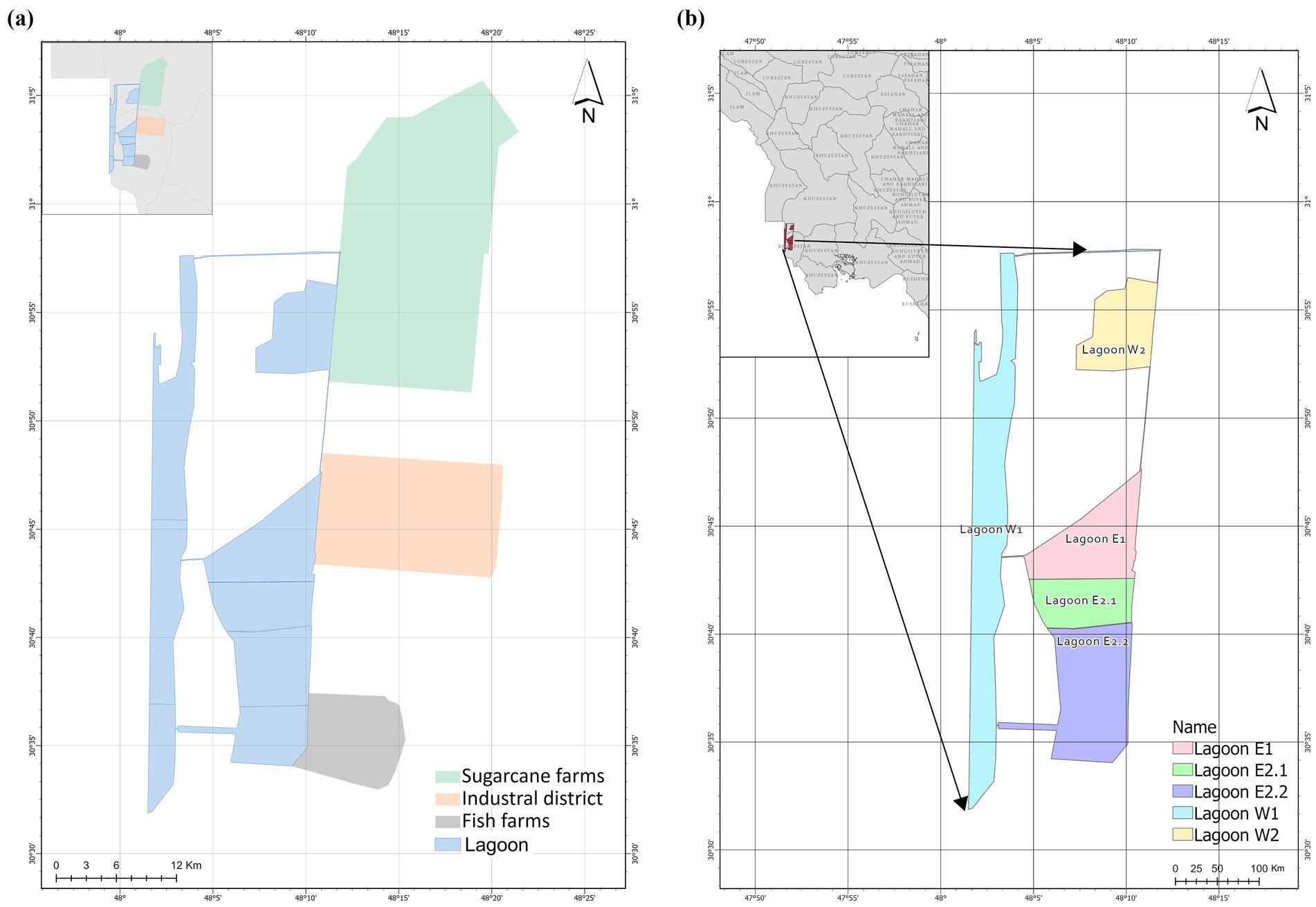
Figure 1. Map of the study area (a) and the flow structure of the lagoon (b).
The lagoon covers an area of 314.84 km2 and is divided geographically into two segments, holding a total storage volume of 242.80 million m3. The surface water resource is used to irrigate sugarcane farms, and subsequently, it flows into the lagoon through a central open channel. The channel makes its first disposal diversion (Lagoon W2) after traveling 10 km toward the city of Khorramshahr. Prior to the first diversion, the primary discharge into Lagoon W2 predominantly comes from sugarcane production. As the central open channel exits Lagoon W2, it branches into two subchannels. One subchannel is further divided into two branches that continue traveling southward to the following sectors (Lagoon E1 and E2). The other subchannel flows toward the Iran-Iraq border until it discharges into Lagoon W1 to the west, which runs geographically parallel to the border. Two waterways located in the center of the area connect Lagoon W1 to lagoons E2.1 and E2.2 in the southeast, helping to balance the water levels of each lagoon. Several outlets have been found discharging directly into W1 and E2.2 surrounding the southernmost region, primarily from fish farms, industries, and agricultural lands.
Through investigation in the study area, surface irrigation has been broadly applied to agricultural production to lower the EC of soil. Based on the data provided by Khuzestan Water & Power Authority (KWPA), the annual average water supply for irrigation and leaching practices is documented at 13.3 m3/s and 14.1 m3/s by two large-scale sugarcane producers, Amir Kabir and Mirza Kochak Khan. Approximately 30 percent of water loss is attributed to irrigation inefficiency and leaching practices, resulting in estimated drainage rates of 3.99 m3/s and 4.24 m3/s from the irrigation systems used in sugarcane production (KWPA, n.d.; Chenari et al., 2011).
Figure 2 illustrates the depth of the groundwater table below the surface in Khuzestan province. Large portions of agricultural production are situated in areas characterized by a notably shallow groundwater table (Mahvi et al., 2005). In Figure 2a, most southern plain landscapes are found in a low-elevation region above sea level in Khuzestan province, where the groundwater table has a relatively shallow depth ranging from 0 to 10 meters, including the study area. These plain landscapes are ideal for irrigation networks, as most are located within this region.
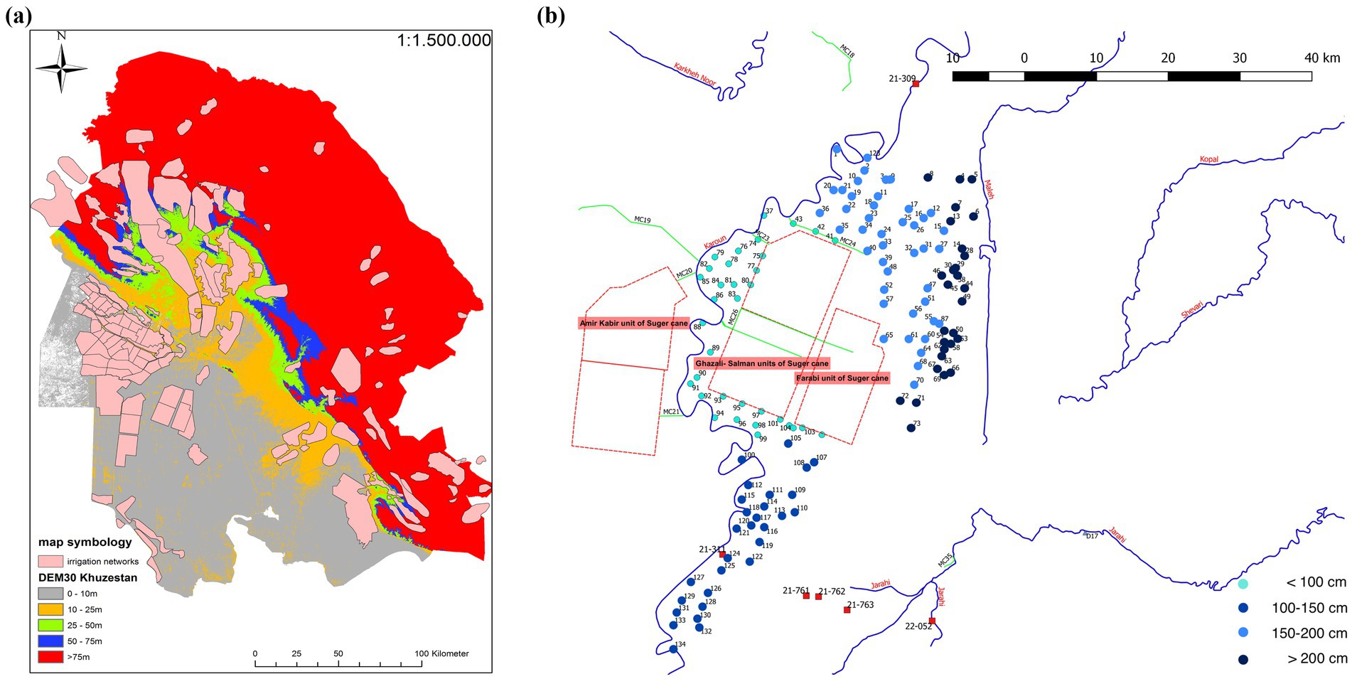
Figure 2. The depth of groundwater table in Khuzestan province (a) and locations and depth of groundwater table of 134 boreholes in the study area (b).
In Figure 2b, the groundwater depth in the study area was investigated by evaluating a total of 134 randomly distributed boreholes. The groundwater table remains and converges at a high level just below the surface, which results in a relatively narrow root zone where root development can be directly restricted for agricultural production. Drainage systems alongside irrigation have been installed to discharge water from both irrigation and leaching in most agricultural areas. A drainage channel has also been established in industrial zones within the study area to pump additional groundwater and directly divert it to lagoons rather than allowing it to flow into the Great Karun.
The data in Table 1 demonstrates that nearly 79 percent of the study area has a shallow groundwater depth of less than 200 cm.
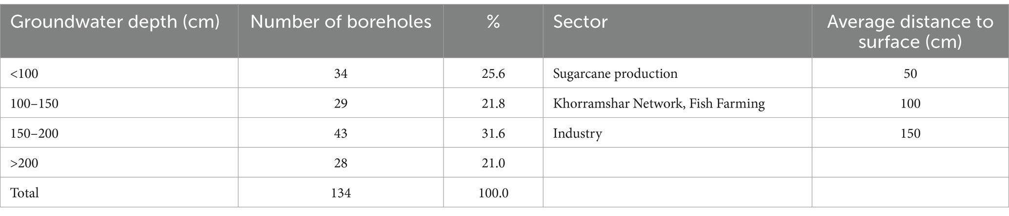
Table 1. Determination of groundwater depth by borehole detection.
The equilibrium between aggregated discharge and the inflow threshold of the lagoon can be used in the conceptual model to evaluate the effectiveness and efficiency of the lagoon as an evaporation pond for saline water disposal (Figure 3). In other words, the degree of effectiveness turns insignificant in case of disequilibrium when aggregated discharge exceeds the inflow threshold of the lagoon. The evaporation rate of each pond is influenced by the salinity level, which will impact the estimation of the inflow capability of the lagoon.
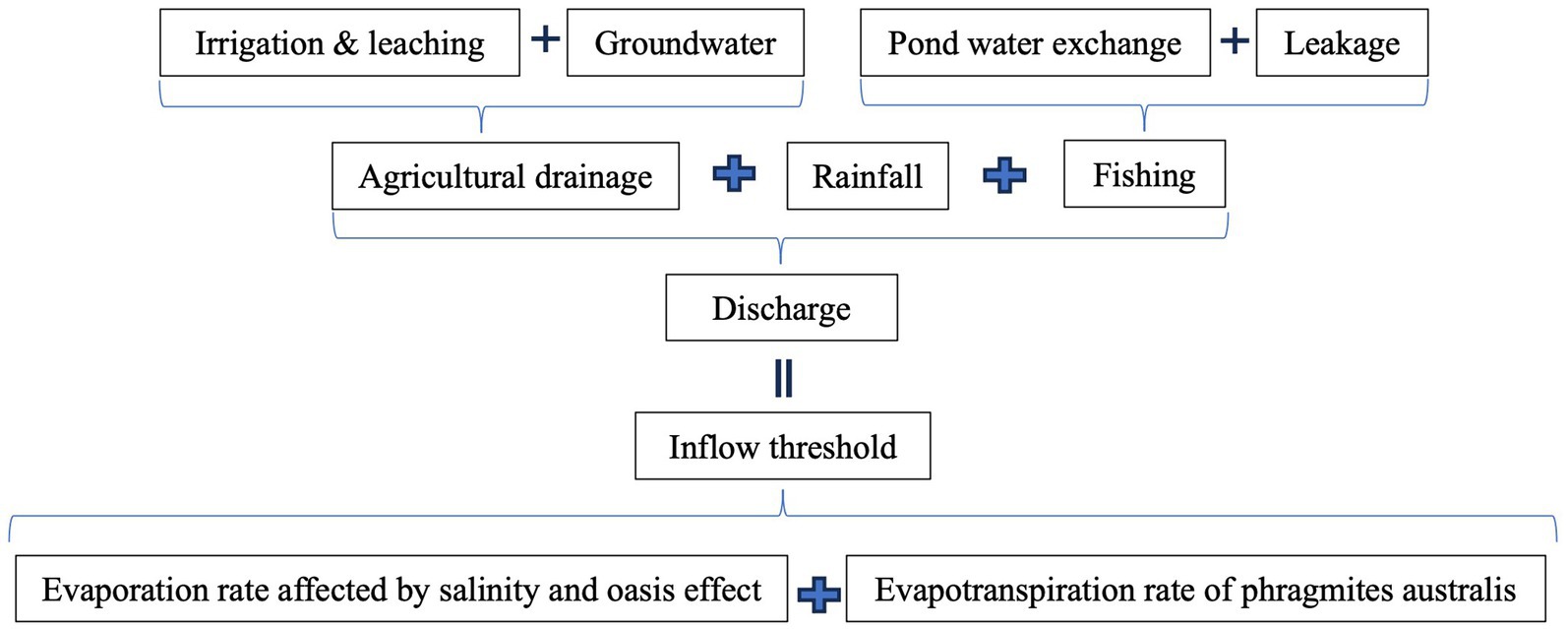
Figure 3. Conceptual model of equilibrium between discharge and inflow threshold.
Groundwater is discharged circumstantially via the drainage system only when the table stays at or exceeds the position of the outlets. The following Formula 1 is used to estimate the groundwater discharge according to land-use activities in different sectors:
Where:
Groundwater discharge (in m3/s).
Penetration rate (in %).
Pore Volume (in %).
Space between outlets and groundwater tables (in m).
Hydraulic conductivity (in m/s).
Coverage area (in km2).
In Formula 1, is between 55 to 60 Vol-% in silt, loam, and clay soil, and it is considered to be 60 percent of a given volume of 1 m2 area since the sandy soil is dominated by soil property in the study area. The penetration rate of water passing through the big pore is measured at 5 percent, sometimes with a maximum of 10 percent in the groundwater zone. An average of 6 percent is used for calculating the water penetration via the big pore since the drainage outlets are situated lower than groundwater tables in the study area, penetration rate varies by location and the layout of the drainage system, with records showing rates from 10 cm/day to 20 cm/day based on data from KWPA.
In addition, the study area receives rainwater at the rate of 5.38 m3/s and encompasses an area of 554.57 km2 of fish farms, wetlands, and sugarcane farms, all of which are equipped with drainage systems. Other areas are not accounted for in the estimation since precipitation is less frequent in an arid region, which often aggravates the drought degree of the soil. Meanwhile, precipitation can be held in the fine pores of the clay and loamy soils after rainfall to replenish the water-holding capacity of soils (Dorraji et al., 2010).
Estimating the total amount of drainage water from fish farms involves calculating groundwater flow and the leakage of fish ponds. The high seepage rate caused by leakage adversely influences the water quantity, pond dynamics, and environment (Sharma et al., 2013). The Formula 2 below is used for leakage loss estimation:
The daily maximum leakage loss was measured at 5000 m3/km2 within pond areas covering 21.6 km2 in the study area. The average production period lasts for 210 days, from April to October, resulting in a maximum leakage flow rate of 0.14 m3/s. Generally, temperature and water quality are crucial factors in determining the water exchange frequency of fish ponds (Bhatnagar and Devi, 2013). An optimal temperature will ensure sufficient oxygen content in the water and prevent fish from suffering lethal damage due to overheating (Zhang et al., 2011). Water exchange operations at fish farms were recorded once a week, totalling 30 times during the production period. Furthermore, a rate of 35.71 m3/s was included to estimate the additional drainage discharge from fish farms.
The monthly inflow threshold calculation, adjusted using the rule-based salinity evaporation model for each lagoon while considering the oasis effect, is presented below:
Where:
monthly inflow threshold (in m3/s).
monthly evaporation rate (in mm).
evaporation reduction by salinity (in %).
dimension of the segment in the lagoon (in km2).
evaporation reduction by the Oasis effect (in %).
Larger lagoons are influenced by the oasis effect, which tends to create their own microclimate, leading to increased humidity above the basin and a reduction in evaporation from the basin (Leaney and Christen, 2000). The evaporation rate increases when the humidity above the water body decreases, the evaporation process is inhibited if the air above the water body is saturated. The main influence of the oasis effect on evaporation relates to the size of the water body (in this case, the lagoon). The evaporation rate is reduced from a maximum value for small water bodies to a fraction of that value for larger water bodies (Morton, 1986). The rule-based scenario, considering the influences of the oasis effect on the evaporation factor in Formula 3, is acknowledged, as the dimensions of the lagoon are sufficiently large to manifest the oasis effect phenomenon in the study area.
The calculation for lagoon W1 is adjusted due to the presence of Phragmites australis, which impacts the gross evaporation dynamics. Phragmites australis is one of the most widespread plant species used in constructed wetlands to treat wastewater, and its evapotranspiration process is the key component in which water moves from the lagoon into the atmosphere through plants (Borin et al., 2011). The gross evaporation dynamics increase because of plant evapotranspiration, with additional transpiration resulting mainly from the loss of water by plants rather than evaporating directly from the surface of the lagoon. Therefore, the calculation integrates both water flow paths, considering the direct evaporation of water from the soil or water body, as well as the indirect transpiration through plants. Formula 4 is expressed below:
Where:
monthly inflow threshold to W1 (in m3/s).
monthly evaporation rate (in mm).
Phragmites australis areas in W1 (in km2).
adjusted evaporation factor based on the plant coefficient (in %).
An exceptionally high salt concentration can physically affect the evaporation dynamics of a solution, including aspects like water surface tension and viscosity. Additionally, the thermal conditions of water bodies, such as surface temperature, layering, and circulation, may also be influenced by salinity (Dama-Fakir and Toerien, 2009). During the field investigation, the southernmost sectors, located south of Lagoon W1 and E2.2, are highly saline. Over time, salinity accumulates, leading to brine conditions where the lagoon water becomes fully saturated. As the concentration of dissolved solids increases, the saturation vapor pressure decreases, resulting in a higher density of the solution (Mickley, 2001; Miller and Millis, 1989). Consequently, the salt content in water bodies reduces the vapor pressure gradient at the water surface, resulting in a lower evaporation rate compared to fresh water. Figure 4 illustrates the salinity levels among different segments in the lagoon.

Figure 4. Level of salinity among different segments in the lagoon.
Table 2 indicates the salinity measurement and the estimated proportion of evaporation rate reduction affected by the level of salinity in the study area.
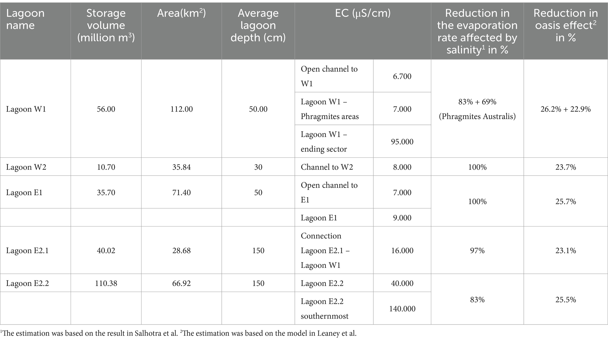
Table 2. Salinity (EC) measurement and evaporation rate reduction in Lagoon West and Lagoon East.
Table 3 presents the estimates for the inflow threshold and overall discharge into the lagoon. The inflow threshold has been modified due to reduced evaporation dynamics. The extent of reduction varies among segments, primarily due to salinity; Lagoons W1 and E2.2 have been significantly impacted, as their salinity values exceed 40,000 μS/cm. The estimate for Lagoon W1 incorporates the evaporation rate from its surface along with the evapotranspiration rate of Phragmites australis. The monthly evaporation rate rises from May to September each year.
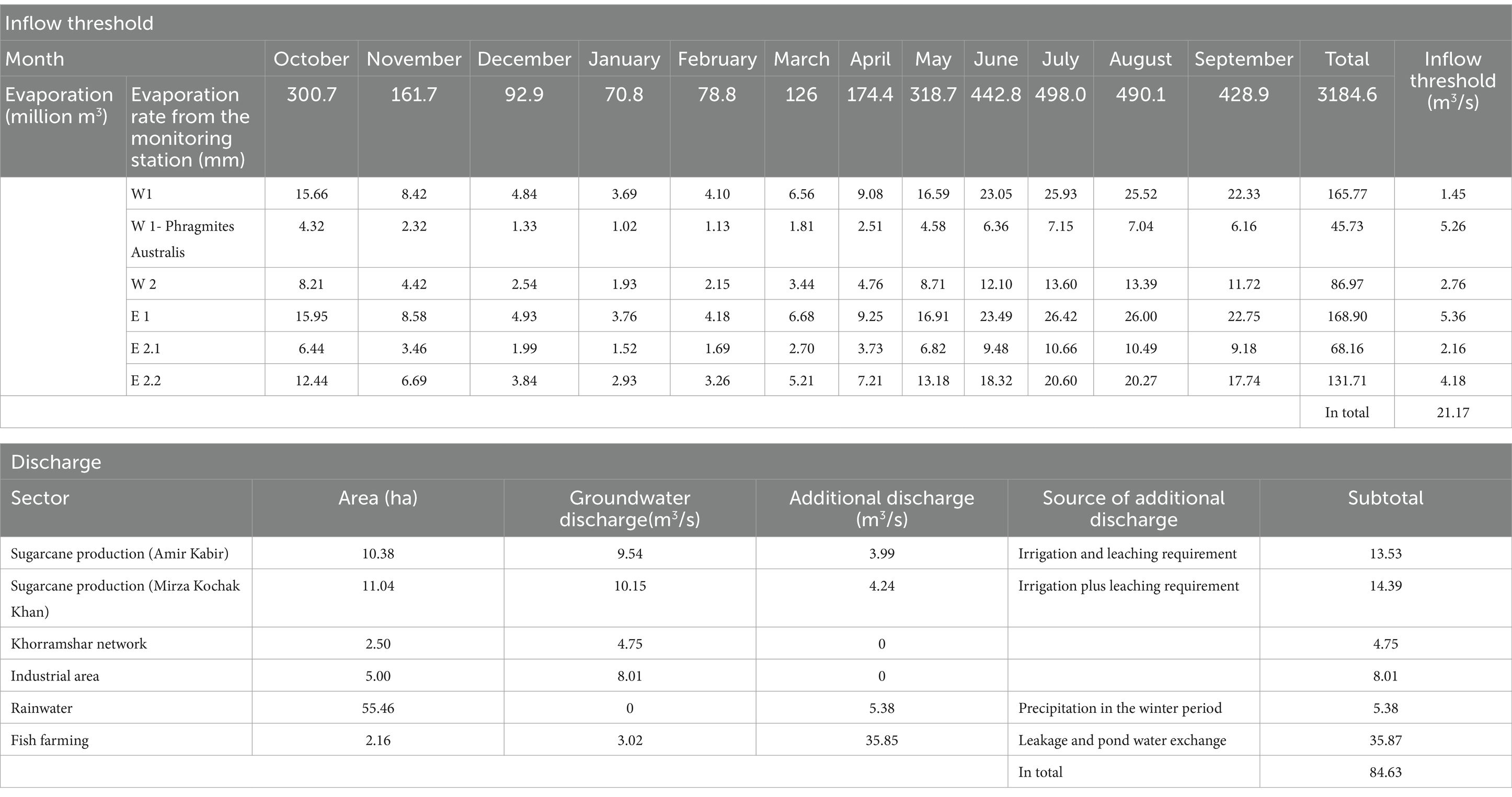
Table 3. Summarization of the equilibrium between overall discharge and inflow threshold of the lagoon.
It was found that the vast majority of discharge in the study area stemmed from groundwater due to the shallow depth and the ineffective distribution of drainage outlets. Consequently, based on land use activities in various sectors, all key players contribute an excess amount of groundwater to the lagoons. Comparing the inflow threshold with the overall discharge reveals an imbalance between the inflow and the potential discharge entering the lagoons, which indicates that the lagoon is inadequate as an evaporation pond for disposing of the saline drainage water in the study area. The inflow threshold is estimated at 21.17 m3/s, while the overall discharge—including contributions from sugarcane, agriculture, industry, and rainfall, via several drainage outlets and channels—is calculated to total 46.05 m3/s. Fish farming contributes significantly to water discharge into the lagoons and has become the primary factor influencing drainage water discharge and salinity deterioration. To maintain optimal conditions for fish growth, a substantial volume of water is exchanged and drained into the lagoons for oxygen and temperature regulation. As a result, fish farms typically operate once a week during the production season, causing the total drainage inflow rate to soar to 84.63 m3/s.
Despite the fact that the management of water supply can be improved by reducing the utilization of surface water resources and increasing irrigation efficiency, the over-discharging of groundwater still leads to a large amount of discharge flowing into lagoons. The focus of management should be shifted from improving the scale of surface water management to groundwater management, and the effectiveness of water governance can be remarkably enhanced since a large proportion of discharge is coming from groundwater. The discharge is predicted to be reduced when the drainage system only collects water from irrigation and leaching operations. In practice, the drainage outlets are placed at an average depth between 130 to 200 cm below the surface in the study area, and the groundwater level consecutively stays over the drainage outlets (Golabi et al., 2009; Moshayedi et al., 2022; Pazira and Homaee, 2010). The discharge exceeds the sum of drainages from irrigation and leaching, primarily due to collecting additional groundwater into the drainage channels. This phenomenon can be found in most areas, especially sugarcane production, with a detected groundwater table 50 cm below the ground.
In the study area, sugarcane production suffers from salinity issues, primarily caused by the capillary rising dynamics of salts from saline groundwater toward the topsoil after the leaching and irrigation periods. The saline groundwater remains above the drainage system during most of the production period and creates a continuous capillary rise in the root zone once the irrigation, precipitation, or leaching stops. The salinization process keeps repeating in the root zone while the shadow depth of the groundwater table and its capillary rising brings more saline groundwater to the soil and increase the level of salinity, resulting in the irrigation inefficiency that irrigation and leaching have to be frequently applied for maintaining the yield. When extremely saline groundwater remains close to the root zone for an extended period without effective drainage, salt accumulation can severely damage root development, leading to a significant reduction in production (Lamsal et al., 1999). Meanwhile, saline groundwater is the primary cause of the salinity issue, which reduces the evaporation rate of the lagoon. The reduction in drainage water disposal capacity consecutively intensifies the disequilibrium between discharge and inflow threshold, ultimately leading to the inefficiency of water governance when considering the lagoon as an evaporation pond for discharge disposal.
The rapid expansion of fish farms, including registered and unregistered, coupled with intensive water exchanges generates severe stress on discharge disposal. A significant volume of water from fish farms has been exchanged and discharged by the drainage system during the production season, which far exceeds the inflow threshold of lagoons. Fish farms are the primary source of discharge to the lagoon, and they are one of the main reasons for the over-flooding of the lagoon. The footprint of the lagoon keeps expanding when discharge cannot be shrunk to equal or less than the inflow threshold, and consequently, the expansion of lagoons may threaten the whole area with the danger of flooding.
A crucial factor often overlooked in the planning of evaporation ponds and the estimation of inflow threshold capacity is the implicit impact that salinity levels have on evaporation rates. The inverse correlation between increased salinity and decreased evaporation rates in open water bodies was considered when estimating that actual evaporation would be reduced as a result of the saline water body (Salhotra et al., 1985). Field measurements indicate that EC values vary among different lagoons, which also reflects variations in evaporation rates. Furthermore, oasis effect lowers the evaporation rates for larger basins compared to smaller ones (with an evaporation factor close to unity). Consequently, factors for reducing evaporation rates based on salinity levels are applied in estimating the inflow threshold for each lagoon.
A lagoon is formed to serve as an evaporation pond for drainage water disposal and ultimately to protect surface water resources in the Khuzestan province from getting polluted. The effectiveness and efficiency of water governance can been enhanced by evaluating the impact that discharge and salinity control made on the drainage system. The lagoon has been found to have a disequilibrium between the overall discharge and inflow threshold. The improper layout of drainage outlets consecutively brought groundwater to the lagoon, while the flourishing fish industry discharged a tremendous amount of water to the lagoon for pond water exchanges.
The result exposes that the water governance system is in a poor state, and the overall performance is not at a desired level, which is based on the short-term purpose of disposing of discharge in the lagoon via evaporation. To address the existing problems, stricter regulations, especially on the management of pond water exchange, should be applied to ensure fish farms control their discharge. Simultaneously, besides emphasizing the importance of improving irrigation and drainage efficiency, more attention should be placed on the salinity control of the lagoon to enhance of evaporation dynamics. Groundwater, a crucial factor influencing salinity levels, can be significantly improved by completely blocking or draining groundwater discharge to the lagoon at a minimum rate.
The original contributions presented in the study are included in the article/supplementary material, further inquiries can be directed to the corresponding author/s.
DM: Formal analysis, Methodology, Writing – original draft, Writing – review & editing. FR: Conceptualization, Investigation, Methodology, Supervision, Validation, Writing – review & editing. HK: Investigation, Project administration, Writing – review & editing. AM: Data curation, Investigation, Project administration, Writing – review & editing.
The author(s) declare that no financial support was received for the research and/or publication of this article.
The authors are grateful for the support from the project organized by Khuzestan Water and Power Authority with Humboldt-Universität zu Berlin.
The authors declare that the research was conducted in the absence of any commercial or financial relationships that could be construed as a potential conflict of interest.
All claims expressed in this article are solely those of the authors and do not necessarily represent those of their affiliated organizations, or those of the publisher, the editors and the reviewers. Any product that may be evaluated in this article, or claim that may be made by its manufacturer, is not guaranteed or endorsed by the publisher.
Akram, M., Azari, A., Nahvi, A., Bakhtiari, Z., and Safaee, H. D. (2013). Subsurface drainage in Khuzestan, Iran: environmentally revisited criteria. Irrig. Drain. 62, 306–314. doi: 10.1002/ird.1774
Bahmaei, A., Albaji, M., Naseri, A. A., and Varjavand, P. (2020). Effect of irrigation type and interval on soil salinity in clay soils in Ahvaz, Iran. Arab. J. Geosci. 13, 1–11. doi: 10.1007/s12517-020-06125-9
Bhatnagar, A., and Devi, P. (2013). Water quality guidelines for the management of pond fish culture. Int. J. Environ. Sci. 3, 1980–2009. doi: 10.6088/ijes.2013030600019
Borin, M., Milani, M., Salvato, M., and Toscano, A. (2011). Evaluation of Phragmites australis (Cav.) Trin. Evapotranspiration in northern and southern Italy. Ecol. Eng. 37, 721–728. doi: 10.1016/j.ecoleng.2010.05.003
Brouwer, C., Hoevenaars, J. P. M., Van Bosch, B. E., Hatcho, N., and Heibloem, M. (1992). Irrigation water management: training manual no. 6: scheme irrigation water needs and supply. Irrigation water management: Training manual no. 6.
Chenari, M., Salimi, S., and Jahromi, H. M. (2011). Field investigation of water-proof material and their effect on controlling seepage. ICID 21st International Congress on Irrigation and Drainage, 15–23 October 2011, Tehran, Iran. R.56.5/Poster/5
Dama-Fakir, P., and Toerien, A. (2009). Evaporation rates on brine produced during membrane treatment of mine water. In: International mine water conference, Pretoria, South Africa, pp. 19–23.
Dorraji, S. S., Golchin, A., and Ahmadi, S. (2010). The effects of hydrophilic polymer and soil salinity on corn growth in sandy and loamy soils. Clean Soil Air Water 38, 584–591. doi: 10.1002/clen.201000017
Golabi, M., Naseri, A. A., and Kashkuli, H. A. (2009). Evaluation of SALTMED model performance in irrigation and drainage of sugarcane farms in Khuzestan province of Iran. J Food Agric Environ 7, 874–880.
Hashemy, N., Khademalrasoul, A., Ghafari, H., and Zahirnia, A. R. (2024). Long-term effects of sugarcane cultivation on the physicochemical quality indices of saline and sodic soils: a case study of South Khuzestan. Appl. Environ. Soil Sci. 2024:Portico. doi: 10.1155/aess/5247959
Hasily, M. A., Golabi, M., and Nasab, S. B. (2020). Study and evaluation of irrigation and drainage networks using analytic hierarchy process in Khuzestan province: a virtual water approach. Agric. Water Manag. 241:106305. doi: 10.1016/j.agwat.2020.106305
KWPA. (n.d.) Khuzestan water and power authority. Available online at: https://kwpa.ir/
Lamsal, K., Paudyal, G. N., and Saeed, M. (1999). Model for assessing impact of salinity on soil water availability and crop yield. Agric. Water Manag. 41, 57–70. doi: 10.1016/s0378-3774(98)00116-4
Leaney, F. W. J., and Christen, E. W. (2000). Evaluating basin leakage rate, disposal capacity and plume development. Monash, VIC: CRC for Catchment Hydrology.
Maghrebi, M., Noori, R., Bhattarai, R., Mundher Yaseen, Z., Tang, Q., Al-Ansari, N., et al. (2020). Iran’s agriculture in the Anthropocene. Earth’s Future 8:1547. doi: 10.1029/2020ef001547
Mahvi, A. H., Nouri, J., Babaei, A. A., and Nabizadeh, R. (2005). Agricultural activities impact on groundwater nitrate pollution. Int. J. Environ. Sci. Technol. 2, 41–47. doi: 10.1007/bf03325856
Mazhar, S., Pellegrini, E., Contin, M., Bravo, C., and De Nobili, M. (2022). Impacts of salinization caused by sea level rise on the biological processes of coastal soils - a review. Front. Environ. Sci. 10:415. doi: 10.3389/fenvs.2022.909415
Mickley, M. C. (2001). Membrane concentrate disposal: practices and regulation, final report (no. 69). US Department of the Interior, Bureau of Reclamation.
Miller, W., and Millis, E. (1989). Estimating evaporation from Utah’s great salt lake using thermal infrared satellite imagery 1. Jawra J. Am. Water Resour. Assoc. 25, 541–550. doi: 10.1111/j.1752-1688.1989.tb03090.x
Minhas, P. S., Ramos, T. B., Ben-Gal, A., and Pereira, L. S. (2020). Coping with salinity in irrigated agriculture: crop evapotranspiration and water management issues. Agric. Water Manag. 227:105832. doi: 10.1016/j.agwat.2019.105832
Moritz, R. (2016). The economic geology of Iran: Mineral deposits and natural resources (M. Ghorbani).
Morton, F. I. (1986). Practical estimates of Lake evaporation. J. Clim. Appl. Meteorol. 25, 371–387. doi: 10.1175/1520-0450(1986)025<0371:peole>2.0.co;2
Moshayedi, B., Najarchi, M., Najafizadeh, M. M., and Khaghani, S. (2022). The sensitivity analysis of the drainage unsteady equations against the depth of drain placement and rainfall time at the shallow water-bearing layers: a case study of Markazi Province, Iran. Water 14:2693. doi: 10.3390/w14172693
Pazira, E., and Homaee, M. (2010). Salt leaching efficiency of subsurface drainage systems at presence of diffusing saline water table boundary: a case study in Khuzestan plains, Iran. In: 9th international drainage symposium held jointly with CIGR and CSBE/SCGAB proceedings, 13-16 June 2010, Québec City Convention Centre, Quebec City, Canada, pp. 1. American Society of Agricultural and Biological Engineers.
Qadir, M., Qureshi, A. S., and Cheraghi, S. A. M. (2008). Extent and characterisation of salt-affected soils in Iran and strategies for their amelioration and management. Land Degrad. Dev. 19, 214–227. doi: 10.1002/ldr.818
Rengasamy, P. (2006). World salinization with emphasis on Australia. J. Exp. Bot. 57, 1017–1023. doi: 10.1093/jxb/erj108
Salem, B. B. (1989). Arid zone forestry: a guide for field technicians, vol. 20. Rome, Italy: FAO, 7–143.
Salhotra, A. M., Adams, E. E., and Harleman, D. R. (1985). Effect of salinity and ionic composition on evaporation: analysis of Dead Sea evaporation pans. Water Resour. Res. 21, 1336–1344. doi: 10.1029/wr021i009p01336
Sánchez, A. S., Nogueira, I. B. R., and Kalid, R. A. (2015). Uses of the reject brine from inland desalination for fish farming, Spirulina cultivation, and irrigation of forage shrub and crops. Desalination 364, 96–107. doi: 10.1016/j.desal.2015.01.034
Schwabe, K. A., Kan, I., and Knapp, K. C. (2006). Drainwater Management for Salinity Mitigation in irrigated agriculture. Am. J. Agric. Econ. 88, 133–149. doi: 10.1111/j.1467-8276.2006.00843.x
Sharma, K. K., Mohapatra, B. C., Das, P. C., Sarkar, B., and Chand, S. (2013). Water budgets for freshwater aquaculture ponds with reference to effluent volume. Agric. Sci. 4, 353–359. doi: 10.4236/as.2013.48051
Stein, E., Gee, E., Adams, J., Irving, K., and Van Niekerk, L. (2021). Advancing the science of environmental flow Management for Protection of temporarily closed estuaries and coastal lagoons. Water 13:595. doi: 10.3390/w13050595
U.S. Energy Information Administration (2024). Country analysis brief: Iran. Washington, DC: U.S. Energy Information Administration.
Velmurugan, A., Swarnam, T. P., Ambast, S. K., and Kumar, N. (2016). Managing waterlogging and soil salinity with a permanent raised bed and furrow system in coastal lowlands of humid tropics. Agric. Water Manag. 168, 56–67. doi: 10.1016/j.agwat.2016.01.020
Xu, H., Tian, Z., He, X., Wang, J., Sun, L., Fischer, G., et al. (2019). Future increases in irrigation water requirement challenge the water-food nexus in the northeast farming region of China. Agric. Water Manag. 213, 594–604. doi: 10.1016/j.agwat.2018.10.045
Keywords: salinity control, discharge, inflow threshold, evaporation rate, irrigation and drainage
Citation: Mao D, Riesbeck F, Khodabakhshi HR and Mahjoobi A (2025) The impacts of irrigation and groundwater drainage induced salinity and overflooding of evaporation ponds in Khuzestan, Iran. Front. Water. 7:1266089. doi: 10.3389/frwa.2025.1266089
Edited by:
Pablo Garcia-Chevesich, Colorado School of Mines, United StatesReviewed by:
Hector Leopoldo Venegas Quinones, University of Arizona, United StatesCopyright © 2025 Mao, Riesbeck, Khodabakhshi and Mahjoobi. This is an open-access article distributed under the terms of the Creative Commons Attribution License (CC BY). The use, distribution or reproduction in other forums is permitted, provided the original author(s) and the copyright owner(s) are credited and that the original publication in this journal is cited, in accordance with accepted academic practice. No use, distribution or reproduction is permitted which does not comply with these terms.
*Correspondence: Di Mao, ZGkubW9keS5tYW9AZ21haWwuY29t
Disclaimer: All claims expressed in this article are solely those of the authors and do not necessarily represent those of their affiliated organizations, or those of the publisher, the editors and the reviewers. Any product that may be evaluated in this article or claim that may be made by its manufacturer is not guaranteed or endorsed by the publisher.
Research integrity at Frontiers
Learn more about the work of our research integrity team to safeguard the quality of each article we publish.