 Bronwen S. Whitney
 John H. Walker
 Neil A. Duncan
 Nicholas J. D. Loughlin
- 1Department of Geography and Environmental Sciences, Northumbria University, Newcastle upon Tyne, United Kingdom
- 2Department of Anthropology, University of Central Florida, Orlando, FL, United States
- 3Natural England, Bristol, United Kingdom
Environmental archeology of the Amazon has conventionally focused on terrestrial spaces, investigating crop domestication and production, agroforestry and anthropogenic soils. Aquatic environments, however, have been given less attention by archeologists and paleoenvironmental scientists alike. The Llanos de Mojos, a 135,000 km2 basin of the Amazon and mosaic landscape of savannas, wetlands and forests, has long been recognized for its archeological record. A variety of anthropogenic earthworks across the region show significant landscape modifications from Pre-Columbian times used for transportation, resource production and control of floodwaters. Here, we investigate the use and management of wetlands, and their interaction in the wider Mojos mosaic landscape, by integrating extensive archeological, paleoenvironmental and GIS datasets. We demonstrate that past human modifications of the landscape enabled the creation of complex wetland-terrestrial system of resource production, in which wetlands were managed, complementary to terrestrial crop production and agroforestry. Across short distances (40 km), land use strategies were heterogeneous despite being connected in time and space. Additionally, mixed wetland-terrestrial resource production was relatively stable during periods of lower rainfall from 1200–1500 CE, implying that this strategy provided flexibility under conditions of variable climate. The wetlands of the Llanos de Mojos are the result of millennia of human intervention and recognition of this deep heritage is required to make informed management and conservation decisions to ensure the future of this culturally and biologically diverse region.
1 Introduction
Sustainably managed wetlands are of critical importance for humanity (Courouble et al., 2021). Wetlands not only provide resources to support livelihoods, they also contribute valuable ecosystem services such as water filtration, habitat provision for a diversity of plants and wildlife, and climate change mitigation through carbon sequestration. Wetlands have been viewed in the past as non-human spaces, and frequently drained for agriculture and pasture (Ogden, 2011; Junk et al., 2013), but their importance to prehistoric societies globally is increasingly recognized (Beach et al., 2009; Yunfei et al., 2009; McKey et al., 2016; Hilbert et al., 2017; Brown et al., 2021). Amazonian examples of anthropogenic soils and forests, including from nearby regions, are well known (Neves et al., 2003; Levis et al., 2017; Clement et al., 2020; Lombardo et al., 2022; Shock, 2024) and many interpretations of Amazonian agricultural history focus on Arawak speakers (Hornborg, 2005; Heckenberger, 2008; Graeber and Wengrow, 2021). The use and management of Amazonian wetlands by people, however, is generally understudied in archeological and paleoenvironmental contexts which conventionally have focused on terrestrial land use systems, specifically crop production. Our lack of understanding of human-wetland interactions through time and space is exacerbated by the highly diverse set of environments they encompass, as well as range of cultural and economic purposes served by wetlands, such as defence, water-power, drinking water, plant harvesting and fishing. Wetlands are not ‘pristine’, therefore understanding the history of their domestication is necessary for their future conservation and management, and to incorporate wetlands into sustainable and climate resilient futures (Courouble et al., 2021).
An extensive wetland, the Llanos de Mojos (or Mojos), is also the setting of a globally important and well-documented archeological landscape of intensive agriculture. Unlike many parts of the tropical Western Hemisphere, the earthworks constructed in eastern Bolivia can be recognized and mapped from the air, using contemporary satellite imagery, as well as 50 years of satellite imagery and aerial photography (Denevan, 1966). Archeological landscape features identified to date include raised fields, drained or ditched fields, mound raised fields, gridiron fields, causeways, canals, dikes, zig-zag features previously termed ‘fish weirs’ (or locally ‘atajaos’), forest islands, monumental mounds, reservoirs, and ring ditches (Walker, 2008a, 2018). Although there are many idiosyncratic, unique landscapes, these features are also arranged in broad, discrete regional patterns, including (1) causeways and fish weirs, (2) monumental mounds and causeways, (3) ring ditches and ditched fields, (4) large raised fields, forest islands, and dikes, and (5) mound raised fields, forest islands, and dikes. The purpose for these anthropogenic features was varied, but they are linked to resource production, navigation and control of waters in the seasonally flooded and wetland mosaic landscape of the Mojos.
Erickson and Walker (2009) argued that by theorizing the archeological record as a landscape rather than a distribution of sites allows us to understand more clearly that the landscape ecology of the region cannot be separated from the history of human habitation. In this paper we demonstrate this point conclusively, by showing that areas of the landscape have their own complex historical geography, which cannot be separated from the history of human communities, with all the complexities which that history implies. To make sense of millennial histories of west central Mojos, we abandon the problem of dividing the landscape into natural and cultural halves, and instead focus on generating records of interactions between people, space and time through analysis of measurable (and mappable) features and evidence of past occupation and landscape management. We examine the spatial distribution of earthworks across the terrestrial and aquatic mosaic, and their relationship to past land use in two neighboring subregions to examine the geographies of resource management and production in this highly diverse and seasonally flooded landscape. This study synthesizes previously published paleoenvironmental and archeological datasets (Walker et al., 2004; Walker, 2011, 2018; Whitney et al., 2014; Duncan et al., 2021), and incorporates new GIS analyses of spatial differences in geo-anthropogenic features.
2 Materials and methods
2.1 Study region
Southwestern Amazonia houses a complexity of ecosystem types and landscapes, including the Llanos de Mojos (Mojos) which is a 135,000 km2 Amazonian sub-basin characterized by a tropical savanna and forest mosaic that presents a unique ecology and archeology (Hanagarth, 1993; Langstroth, 1996; Denevan, 2001; Erickson, 2010). The savanna-wetland-forest mosaic of Mojos is shaped in part by annual flooding caused by the South American summer monsoon. The interaction between the annual flood and the very low relief of the basin determines the distribution of vegetation types in this mosaic; permanent and seasonally inundated savannas are interspersed with forest on higher terrain (forest islands) and river levees (Pouilly et al., 2004). The geology of the basin is comprised of unconsolidated Quaternary and clayey sediments (Clapperton, 1993) and low forest cover allows for a highly dynamic geomorphology especially around the annual flooding of the Rio Mamoré, the main river of the basin and tributary of the Madeira River of the Amazonia river system. Annual temperature is 25°C (Hanagarth, 1993), and in the region of Santa Ana del Yacuma, mean annual precipitation is 1,500 mm (Lombardo et al., 2013). There are no paleoclimate records from Mojos but speleothem records from south of the region (the eastern Andean flank) (Apaéstegui et al., 2018) show rising precipitation over the last millennium, in line with the broader pattern of higher moisture levels in the late Holocene in southern Amazonia (Mayle et al., 2000; Carson et al., 2014), but with a period of lower rainfall from 1200–1500 CE.
The Mojos savanna is the setting for a diverse mosaic of earthworks (Denevan, 1966; Erickson, 2006) and decades of investigative efforts have made it clear that the Mojos is an example of humans modifying and affecting the landscape. Within the several distinctive patterns of features on the landscape listed above, West Central Mojos (WCM) is one of the more clearly definable. Large raised fields, which on average are about 17 m wide and 200 m long, but with many examples longer than 500 m, are found exclusively in an area near the lower Iruyañez, Omi, Yacuma, and Rapulo rivers, totaling ca. 10,000 km2. WCM is open with less forest cover (Walker, 2018) compared with other regions in the Mojos. The open savanna between the Omi and Iruyañez, for example, or between the Yacuma and the Omi, resembles a sea of grass, dotted with islas del bosque or “forest islands.” Additionally, recent investigations using satellite imagery and confirmed in limited surveys on the ground, have revealed a network of weirs across the region, in close association with raised fields, generally occurring in the savannas between the rivers, especially between the Iruyañez and Omi Rivers, and between the Omi and Yacuma Rivers. Erickson (2000) hypothesized that similar structures from the Baures subregion of the Mojos were built primarily for managing and harvesting of fish. This characterization was confirmed by later research (McKey et al., 2016; Prestes-Carneiro and Béarez, 2017). Duncan et al. (2021) having investigated the paleoenvironmental history of the wetlands, have expanded upon the resources provided from managed wetlands beyond fish protein and thus ‘fish’ weir may not be wholly appropriate in all contexts. To avoid assuming the functions of the weir structures, we propose the use of the local term atajao, which refers to ponds made by the diversion of streams and floodwater.
An additional defining characteristic of the southern WCM is the presence of a large (ca. 200 km2) permanent wetland in the middle of the savanna between the Omi and Yacuma Rivers. Unlike the seasonally inundated savannas that display a complex mosaic of dry and wet, drained (or not) by small seasonal creeks, the Quinato wetland is distinctive because it contains water year-round and covers hundreds of square kilometers. Along with the rivers that lie both north and south of it, the Quinato wetland is part of a landscape of raised fields, forest islands, and atajaos. Given the clear association between these structures and the Quinato wetland, this study integrates and compares archeological, paleoenvironmental and GIS datasets in both of the wetland (southern) and river-savanna (northern) subregions of the WCM to understand the use of coupled terrestrial-wetland ‘land use’ systems and the human and environmental histories of past wetland resource management in the Mojos.
2.2 Spatial analysis methods
During the period covering 2005 to 2023, archeology students at the University of Central Florida have contributed to an expanding dataset of mapped features through use of online geographical tools, specifically Google Maps, Google Earth, OpenStreetMap, QGIS, and ArcGIS Online to digitize archeological features from open access satellite imagery, building upon the 50 years of LANDSAT imagery used to map the region. To date this group has mapped more than 44,000 large raised fields, 5,500 forest islands, several hundred kilometers of river and water network, over 327,000 mound raised fields, and hundreds of other features such as contemporary farms, visible ring ditches, earthen causeways, and atajaos (Figure 1). These digitized spatial data were uploaded to ArcGIS Pro for further spatial analysis.
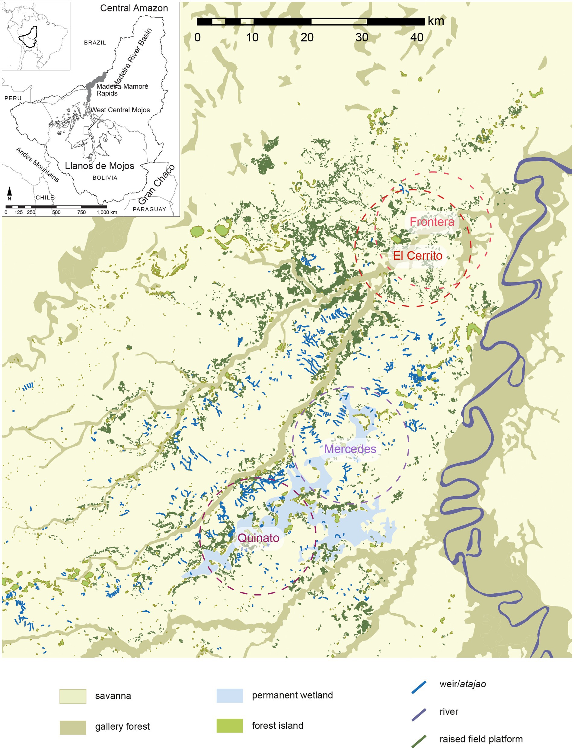
Figure 1. Landscape of West Central Mojos created from manual mapping of archeological features and existing vegetation and geographical datasets. The locations of the four 10-km radius study areas are shown by the dashed circles which are shown in detail Figure 2.
Many features, such as rows and columns of mound raised fields, or large raised fields that sometimes measure 20 m by 1,000 m, are easy to outline on the imagery. Other distinctions, like that between flooded gallery forest and the high ground of forest islands, are not obvious. Where the distinctions are less clear, and where we have not surveyed the forest islands on foot, imagery is combined with an open source DEM layer (ArcGIS dataset) (Hansen et al., 2013) to verify forest islands against the elevation data. Although the DEM provides estimates of tree canopy height, the use of this dataset allows forest islands to be more clearly recognized. As the quality and quantity of imagery increases, the dataset of archeological features will improve owing to this diversity independent views of the same features.
To better understand the geographic context, archeology and past land use, landscape elements were counted within a 10-kilometer radius for each paleoenvironmental core analyzed (Figure 2). This distance was chosen to enable a characterization of the landscape elements around each core, to fully capture the potential spatial extent of source pollen and charcoal, and to avoid issues presented by defining a ‘site’ in conventional archeological terms recognizing a person’s daily movement among fields and rivers could have easily comprised several kilometers (Walker, 2018). The proximity of the northern lake sites means there is overlap in the analysis. Descriptive statistics are presented here (Figure 3), using the basic functions of the GIS (ArcGIS Pro) to measure the number and area of features within a threshold distance (10 km) of the coring locations. Full results are available in Supplementary materials.
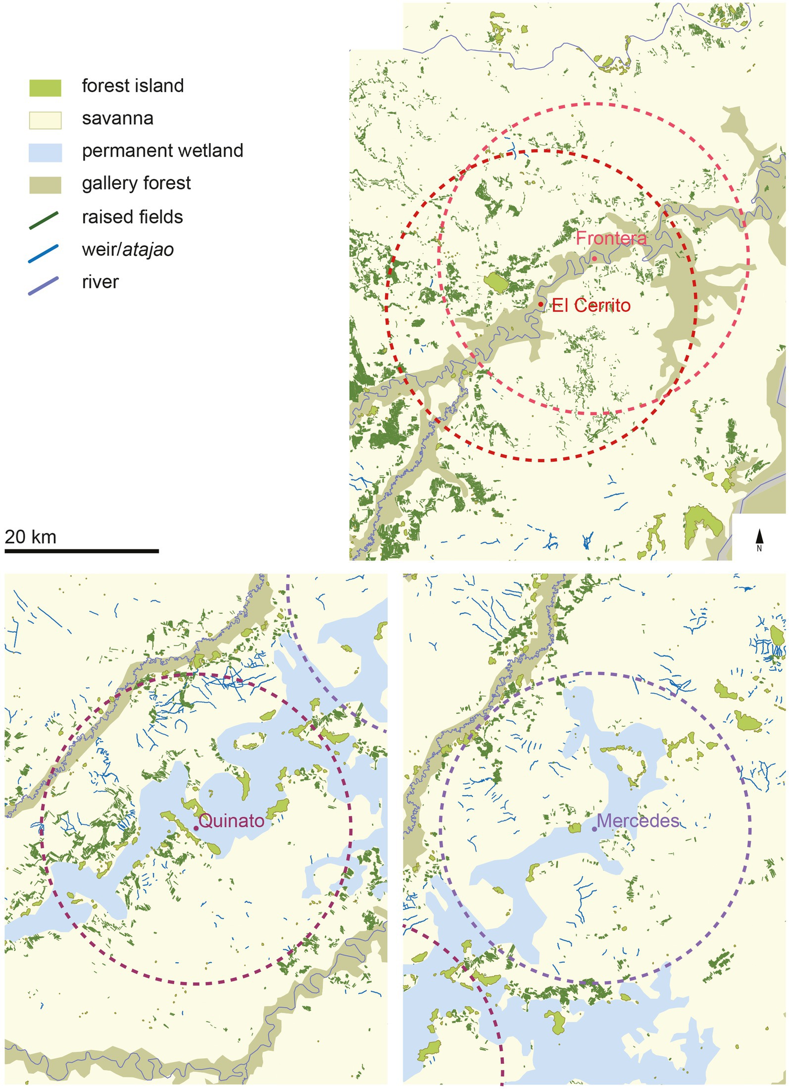
Figure 2. Location of four study areas with detail of landscape elements included for each area of spatial analysis. The locations of the sediment cores for paleoenvironmental investigation (Figures 5, 6) are shown by the dots in the center of each circle.

Figure 3. Summary statistics of landscape and archeological features of the two subregions of the WCM, northern El Cerro region and the southern Quinato wetland. Colored rectangles denote the proportion of each feature and weirs are shown as relative length.
2.3 Paleo methods
This study incorporates previously published paleoenvironmental data from a total of four sediment cores that were extracted from the northern (2) and southern (2) subregions within West Central Mojos. In the northern subregion, cores were extracted from each of two lakes (Figure 2) associated with the Iruyañez River and near the El Cerro forest island (Whitney et al., 2014). In the south, two cores (Figure 2) were taken from the Quinato wetland a large permanent wetland. (Duncan et al., 2021). A sequence of 52 radiocarbon dates from across WCM (Figure 4) derived from material excavated in forest islands were collated from previous studies and presented alongside the paleoenvironmental data (Walker, 2018).
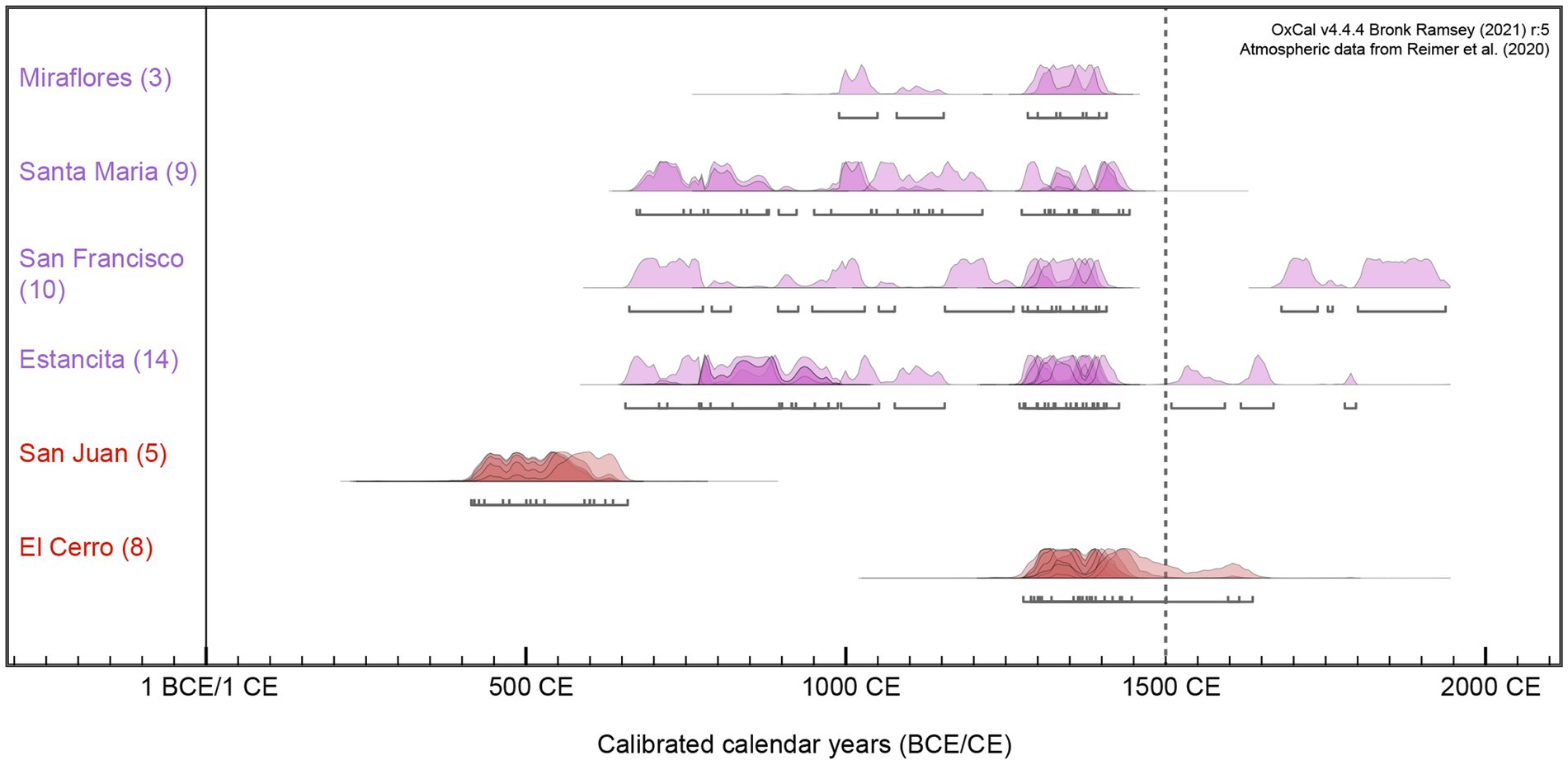
Figure 4. Results of radiocarbon dating from excavated islands in the WCM. The top (purple) sites are islands located in the southern wetland area; the northern island sites are denoted in red.
2.3.1 El Cerro (northern) subregion
Located 40 km north of the Quinato wetland, the El Cerro raised field region is characterized by the ‘cerro’ or hill, a singular forested rock formation measuring 40 m in height and covering 10 ha that dominates the landscape. The formation is forested and is also surrounded by ca. 110 ha of higher, forested terrain that does not sustain flooding during the wet season (Walker, 2004; Whitney et al., 2014). The Cerro is located 2 km from the Iruyañez River, and therefore the region is connected to the permanent waterways of the Mojos. Gallery forest lines the river margins and the region is abundantly covered in raised fields (Figure 2). Previously published analyses, summarized here, were derived from analysis of sediments extracted from two small oxbow lakes (El Cerrito and Frontera) located ca. 4 km apart along the Iruyañez River. Both cores were analyzed for pollen and charcoal, and sedimentary horizons demarking key changes within these proxies were radiocarbon dated. The analysis was conducted on the upper core horizons owing to variable pollen preservation in lower sections. At El Cerrito (LEC), 80 cm of sediment dating to 1080 CE was analyzed, and Frontera (LF) has an analysis length and age of 60 cm and 360 CE, respectively (Figure 5). All methodological details and full results are available in Whitney et al. (2014) and details of radiocarbon dating are provided in the Supplementary materials.
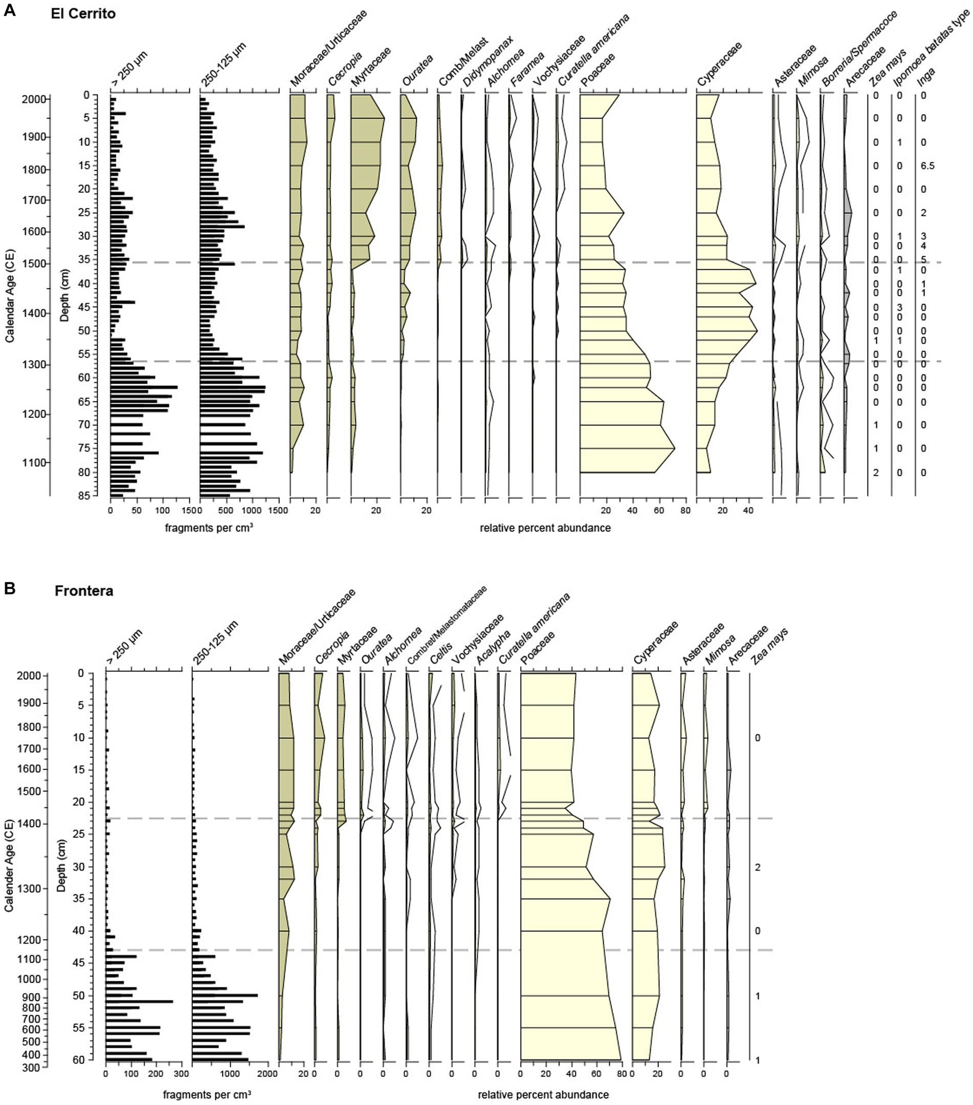
Figure 5. Charcoal and pollen datasets from (A) El Cerrito and (B) Frontera lakes in the northern ‘El Cerro’ subregion of the WCM. Silhouette colors are used to denote the landscape feature that is the likely origin of each paleoindicator. Details in Whitney et al. (2014).
2.3.2 Quinato (southern) subregion
Located between the Yacuma and Omi Rivers, the Quinato wetland occupies a 200 km2 area within an old paleo channel of the Beni River that has been inactive for an estimated 12,000 years (Lombardo, 2014). The wetland is shallow and covered in emergent and floating vegetation, and although it varies seasonally, the Quinato wetland is permanent and holds water all year. Unlike the El Cerro (northern) subregion and other active river channels in the Mojos, the Quinato has no forested levees, but there are non-contiguous fragments of forested habitat on forest islands adjacent to the wetland. Abundant raised fields and atajaos have been identified and mapped in the area surrounding the wetland. Approximately three quarters of surveyed forest islands along the wetland margin show evidence of occupation, with ceramics, earthworks such as ring ditches, and dark soils. Previously published analyses, summarized here, were derived from two short sediment cores, Mercedes (ME) (95 cm, 5550 BCE) and Quinato-Miraflores (QM) (97 cm, 3210 BCE), were extracted from locations ca. 22 km apart within the Quinato wetland. Pollen, charcoal, diatom and phytolith analysis were performed on both cores, although pollen is preserved only in the top organic sediments of QM (58 cm) and ME (36 cm). Diatoms were analyzed to characterize wetland flood regime from six horizons in each core, and diatoms were too poorly preserved in the deepest samples at QM (83 cm) and ME (59 cm, 81 cm) for analysis. Chronology was constrained through radiocarbon dating of discrete sediment horizons. All methodological details and full results are available in Duncan et al. (2021). Details of radiocarbon dating are provided in the Supplementary materials.
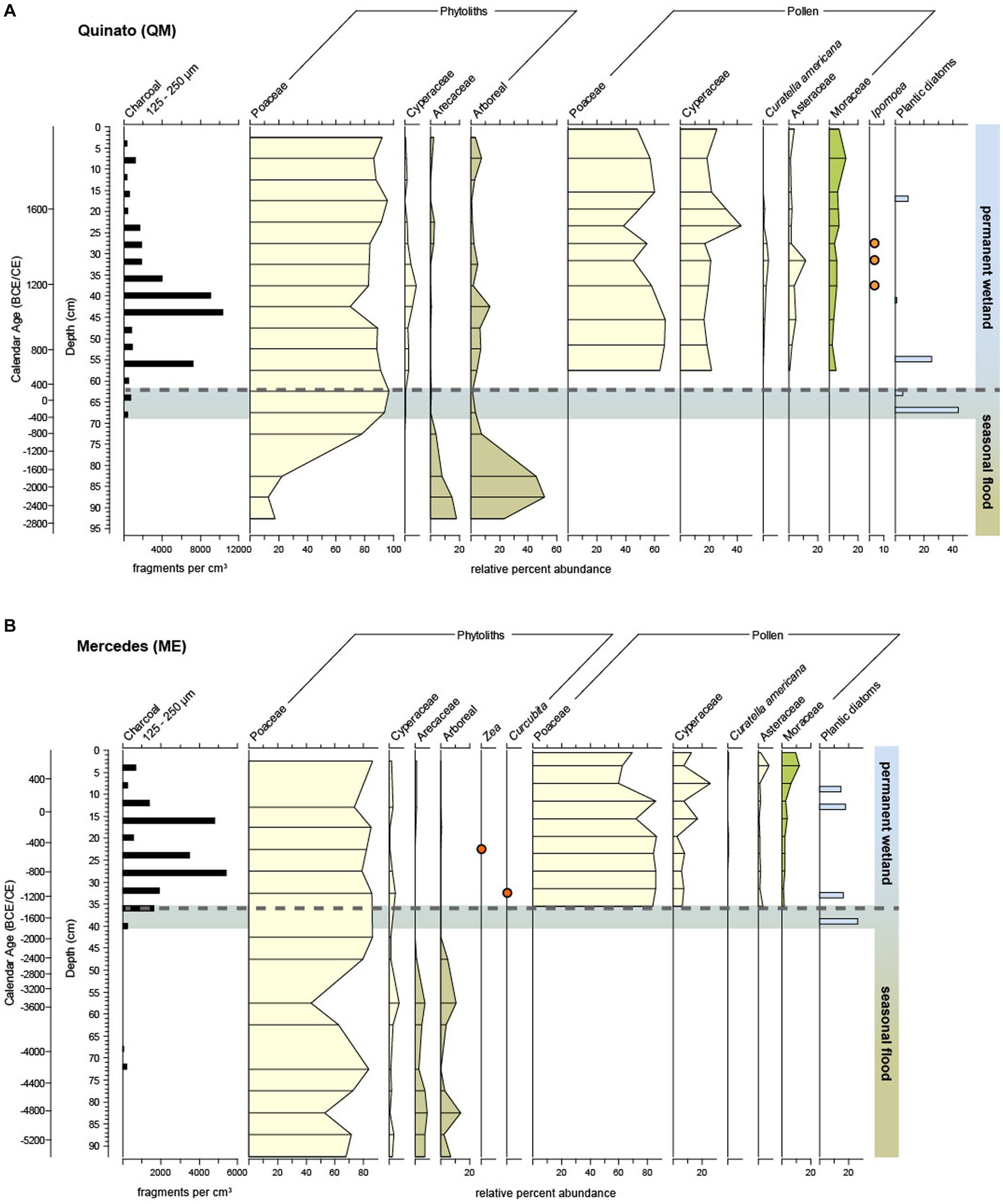
Figure 6. Charcoal, pollen, phytolith and diatom datasets from (A) Quinato and (B) Mercedes cores in the southern ‘Quinato’ subregion of the WCM. Silhouette colors are used to denote the landscape feature that is the likely origin of each paleoindicator. The graded bar reflects the transition to managed wetlands based on the presence of diatoms and decline of seasonally-inundated forest along with extensive burning. Details in Duncan et al. (2021).
3 Results and interpretation
3.1 Spatial dimensions of socio-environmental interactions in the WCM
The strongest geographical difference between the two subregions is their relationship to permanent wetlands and gallery forests. Within the El Cerro region, LEC and LF contain 50.6 km2 and 54.6 km2 of gallery forest within the standardized sample area (314.1 km2), respectively. Neither of these two northern cores is located within 10 km of any permanent wetland area. In the south, the situation is nearly reversed as within the standard sampling area, QM is surrounded by 67.8 km2 of permanent wetland, and only 6.3 km2 of gallery forest. ME is located within 10 km of 49.0 km2 of permanent wetland and the lowest value of galley forest (0.2 km2) within the four sampling areas. The relative rarity of gallery forest within 10 km of the southern cores is owing to their distance from any navigable river. Atajaos are found throughout West Central Mojos, but these are found in greater abundance in the two southern sample areas (Robinson, 2023; Figure 2). Although the area is not estimated owing to their shape, quantity and length estimates are provided (Figure 3). The LEC sample includes 5 atajaos, totaling 2.5 km in length, while LF includes 6 atajaos, totaling 2.6 km in length. In the southern (Quinato) sampling areas, the numbers are higher by an order of magnitude. The QM sample includes 163 atajaos totaling 47.1 km in length, and ME includes 82 atajaos totaling 34.8 km in length.
Across the WCM, large raised fields are clustered along rivers and streams, and around forest islands, but are also found kilometers away from both islands and rivers. Forest islands and raised fields are found in both the northern (El Cerro) and southern (Quinato) study areas, but they differ in terms of area and quantity. The northern location, near the Iruyañez River and the Cerro forest island, is the part of WCM with the largest and best preserved fields, many wider than 20 m and longer than 500 m, and a few as long as 1,000 m. This landscape can be thought of as oriented around the Iruyañez River, with a sizable gallery forest, and easy access to the river, which is a major tributary of the Mamore. The fields are oriented roughly perpendicular, on the NS-EW axes. The LEC sample contains 4,946 raised field platforms totaling 9.5 km2 of planting surface and the LF sample contains 4,308 field platforms totaling 6.4 km2 of planting surface. The modal orientations of southern region are oriented roughly perpendicular on NWSE-NESW axes. The southern locations, in the Quinato wetland, are bounded by large raised fields that are easy to measure from satellite imagery, but not as easy to distinguish on the ground. Raised fields bounding the Quinato wetland were not observed on the ground (in 2007) until the guidance of high resolution satellite imagery suggested their presence (in 2018). In the south, raised field platforms are larger but less numerous. Fields in the QM sampling area includes 1,998 field platforms totaling 7.7 km2 in area, while the ME sample includes 1,078 field platforms totaling 3.6 km2 in area (not counting canals or negative space between and around the fields).
Forest islands are present in both northern El Cerro and southern Quinato sites. There are 11.6 km2 of forest islands that edge the Quinato wetland. Surveys at forest islands in the south have confirmed the presence of earthworks within the forest, including ring ditches and artificial ponds or reservoirs. Estancita, Santa Maria, and San Francisco forest islands all have circular earthworks, although these features are not visible on air photos and satellite imagery (Walker, 2008b). Ring ditches place this location within a pan-Amazonian pattern of circular ditches (De Souza et al., 2018 Saunaluoma et al., 2018), and suggest that many forest islands conceal earthworks, as demonstrated by recent LiDAR surveys (Prümers et al., 2022). Forest island habitation is not coterminous with the boundaries of the forest islands and includes distinctions between within- and outside- ring ditch habitation.
3.2 Temporal dimensions of socio-environmental interactions in the WCM
3.2.1 El Cerro
The pollen and charcoal data from LEC and LF show consistent signals in the pollen and charcoal records (Figure 5). The charcoal data from the two lakes show evidence of extensive fire use followed by a decline in burning ca. 1250 CE. The high charcoal values we hypothesize relate to burning for land clearance, with the reduction in fire use at 1250 CE representing a change in land use management strategies. This interpretation is corroborated by the pollen data from two lakes which demonstrate a high abundance of herb taxa (sedges and grasses) at the base of the core and few trees on the landscape, either savanna or gallery forest taxa. The relatively low values of arboreal cover is coeval with maize pollen. Maize pollen abundance is rare but the large grains are poorly dispersed and the low but consistent values reflect local presence. Following the decline in charcoal values, there is a rise in arboreal pollen (at LF), and the appearance of sweet potato pollen (Ipomoea batatas type) and, after 1430 CE, Inga sp. which is a colonizing leguminous tree, species of which provide edible fruits. The presence of Inga and Ipomoea in addition to Zea might signal a combined agroforestry-crop production farming technique, such as ‘Inga alley’ farming (Hands, 2021), agroforestry in eastern Mojos (Erickson and Balée, 2006) or the traditional ‘forest orchard’ gardening of the Maya in Central America (Ford, 2022). Following ca. 1450 CE the pollen records show a rise in tree growth in both gallery forests and savannas, the latter of which is characterized by low but persistent abundances of Curatella americana (the sandpaper tree) a key savanna indicator (Jones et al., 2011). Savannas, however, remain open and the tree growth in the gallery forest is moderate given that Moraceae (gallery) remain relatively consistent throughout the record. Maize, sweet potato and Inga co-cultivation initially remain high, but then decline into the post-Jesuit period (after 1800 CE).
The pollen evidence of maize and other crop production is corroborated by dated occupation layers at the forest island of El Cerro. The ‘El Cerro’ forest island contains an extensive depth of anthrosols, dark soils and burnt clays, and artifacts located from the soil surface to depth of 110 cm revealed in trench and shovel test excavations (Walker, 2004). Radiocarbon dating of charcoal associated with the ceramic layer spans ca. 1300 to 1500 ‘CE (Figure 4), in line with the second phase of land use inferred in the pollen and charcoal records of the LEC and LF cores. The abundance of charcoal in soils dating from 1300–1500 CE, combined with the relatively muted rise in Moraceae pollen values following 1500 CE, suggests that gallery forest was less cleared than previously interpreted (Whitney et al., 2014) for El Cerro and that the landscape was actively managed for fuel, among other forest products, during this period. Ceramics comprise a diverse range of forms, including large vessels (>1 m diameter), that suggest cooking for large numbers of people and a mix of food processing forms including grinders and graters. Although these ceramic dates at El Cerro cluster strongly with the land use signal from the paleoenvironmental records, this region of Central West Mojos was continuously occupied by raised field farmers from at least the 6th century, as shown by excavations at San Juan ca. 12 km SW of El Cerro site (Walker, 2018) that establish forest island habitation between 450 CE and 650 CE. This long-standing occupation is further supported by the pollen record at LF, which show maize pollen as early as 360 CE.
3.2.2 Quinato wetland
Proxy indicators are variably preserved in the QM and ME sediment cores. Phytoliths and charcoal are preserved throughout because they can withstand some oxidation, and preserve in soils or on surfaces (Piperno, 2001; Whitlock and Larsen, 2001; Pearsall, 2015). Pollen and diatoms, however, are less robust and are preserved only within the organics-rich sections of the cores. Pollen is abundant in these upper core sections but the assemblages are dominated by the grasses and sedges of the local wetland vegetation, a signal that is expected in accordance with pollen source theory (e.g., Jacobson and Bradshaw, 1981). However, arboreal taxa such as Moraceae and Curtella americana, constituent taxa of the forest islands and savannas, respectively, are present in low abundance. Additionally, both coring sites are located ca. 500 m from the nearest raised fields and forest islands, therefore the pollen of cultigens such as Ipomoea are under-represented due to their large size and thus limited dispersal, but their presence alongside Zea mays and Curcubita phytoliths, do provide evidence of their cultivation.
Despite being located ca. 22 km apart, both cores show a consistent signature in that there was a higher-than-modern abundances of trees in the paleochannel prior to wetland initiation, as indicated by the presence of arboreal phytoliths. Very high levels of charcoal concentrations follow a decline in arboreal phytoliths, after which diatoms are indicative of wet conditions. The initial peak in charcoal we interpret to reflect clearance of woody vegetation in the seasonally inundated channel before a transition toward the establishment of permanently flooded conditions. Although consistent in the nature and direction of these environmental changes, the timing of the transition occurs ca. 2000 years apart. The initiation of human impact on the landscape begins with burning, and steeply rising charcoal values combined with indicators full wetland conditions, specifically the combination of preserved pollen and diatoms, estimated to have been established by as early as 1500 BCE and 300 CE at ME and QM, respectively. Duncan et al. (2021) interpret this spatio-temporal variability to reflect management of paired terrestrial-aquatic localities, where patches were added and modified in time and space within the 200 km2 area of the Quinato wetland. The charcoal records indicate that significant burning within the locality of each core coincides with local hydrological change and the establishment of permanent wetlands.
There was continuity in the use of paired aquatic-terrestrial systems from ca. 300 CE until the European period (1500 CE). Both aquatic and terrestrial environments were maintained; the aquatic environment was flooded and the terrestrial environment was open, as indicated by pollen assemblages largely devoid of arboreal taxa, which is partly owing to the highly localized pollen signatures in wetland environments. However, in the post-European period, there is a change in two key arboreal pollen types which are indicative of a shift in land use pressure in the terrestrial components of the mosaic. Moraceae pollen shows a clear but modest rise, indicating an increase in forest cover on the forest islands and gallery forests. The pattern of higher arboreal cover on forest islands is similar to that observed in the records at El Cerro, and both of these changes are owing to population decline associated with European colonization. The forest islands located on the edge of the Quinato wetland were significant centers of habitation as they are characterized by ubiquitous archeological ceramics and earthworks. Excavations at forest islands in the Quinato southern region, Estancita, Santa Maria, and San Francisco date from ca 650 CE to 1450 CE but the very low values of Moraceae pollen recovered in the sediment cores from the period dating prior to 650 CE suggests that this long history of habitation extends even further back in time, given that tree cover would have been lower-than-modern on inhabited forest islands. Concomitant with the changes in Moraceae, there is a decrease in the savanna ‘sandpaper tree’ C. americana that reflects new pressures on savanna ecosystems owing to European colonization and the introduction of cattle grazing pressures in the 17th century (Walker, 2018; Duncan et al., 2021).
4 Discussion
At landscape scale, there are differences between Quinato and El Cerro regions in terms of combinations of features, land use, and timing of changes inferred from the four sediment cores. The landscape in the south contains greater opportunity for wetland-based economic activities, both in the permanent wetland from which the cores were taken and from neighboring artificial or domesticated wetlands. Estimating the area of domesticated wetlands that were created by atajaos through harvesting and maintaining rain and floodwater is not straightforward, but it is likely to be strongly related to the total length of the earthworks (Figure 3), which are an order of magnitude greater in the southern analysis region. The paleoenvironmental results also demonstrate spatio-temporal heterogeneity within the Quinato wetland, as the timing of wetland development differs among the two cores (ca. 10 km apart) and shows that people manipulated and managed different areas with the wetland at different times. In both cases, the charcoal record rises steeply with the establishment of permanent flooding, and therefore indicates that terrestrial and wetland systems are managed contemporaneously and that this complex system of resource extraction was developed to make use of and improve the Mojos mosaic landscape. There is no evidence of change in the pre-European period of this dual terrestrial and aquatic system, which implies that although precipitation is highly variable in the most recent millennium (Apaéstegui et al., 2018; De Souza et al., 2019), wetland management was adaptable to climatically driven variations in floodwater extent and duration.
The combination of raised fields, forest islands, and gallery forest at El Cerro has a different history to that of the Quinato region. Similar to Quinato, there is a clear indication of terrestrial land use through high charcoal abundances from at least 1080 CE (LC) and 360 CE (LF), crop pollen and clearance of the gallery forest. Ethnohistorical evidence shows that Mojos communities used rivers and wetlands for navigation and fishing (Éder, 1888; Block, 1994), and these activities unfortunately are not yet directly captured by our paleoecological or archeological datasets. Some atajaos are present here but at a much smaller scale compared to Quinato. Entirely distinctive to the Quinato wetland, however, is evidence for a change in land use activities at 1200–1300 CE, whereby the previous management strategy of frequent maintenance burns and maize production shifts toward use of arboreal resources and sweet potato crops. The latter part of this period corresponds to the presence of Inga which points to possible polyculture agroforestry alongside crop production. The paleoenvironmental evidence points to the presence of woodland resources shown through gallery and savanna tree pollen and less burning, while radiocarbon dating of occupation layers overlap most strongly with this period in the environmental record. Together, the combined datasets indicate a field-forest-river production system with managed arboreal resources associated with potentially more intensive land use or occupation. This period coincides with lower precipitation, as indicated by the nearest speleothem record (Apaéstegui et al., 2018), suggesting that the field-forest-river system was better suited to conditions of lower flooding and rainfall.
In the mosaic landscape of Mojos, the patterns of land use in space and time were complex, as different landscape components were managed and used at different times. This complexity occurs even within relatively short distances, as the northern El Cerro subregion is approximately 40 km away from the Quinato wetland. Although there are differences in land use in time and space, owing to the proximity of El Cerro and Quinato, we argue that the land use systems and the people using the land were connected in the past. The Mojos in general, and the WCM in particular, is highly navigable by canoe and higher flood waters in the wet season would have permitted easy communication between the wetland and the Omi, Yacuma and Iruyañez Rivers. Despite this connectivity, however, we demonstrate change in the field-forest-river system of El Cerro that is unobserved in the Quinato record and suggests that the wetland-field-forest system of Quinato is more resilient to variations in rainfall. Intensive agriculture around the world is often characterized by resilience (Stone, 2022). Such resilience in this example could be owing to the variety of economic activities that it enabled, analogous to early rice cultivation in China that was found to be associated with a variety of fish and other plant remains (Gross and Zhao, 2014), Mesoamerican chinampa agriculture (Morehart, 2012) or wetlands in southern Amazonia with semi-domesticated rice and fish remains (Hilbert et al., 2017; Prestes-Carneiro et al., 2020). However, the use of atajaos to manage floodwaters in the wetlands also implies that this was a dynamic system that allowed people to easily adapt to rainfall variations. Diversified agricultural systems combining agroforestry and polyculture have all been suggested as potential models of crop production in the global south (Ford and Nigh, 2009; Hands, 2021; Rasmussen et al., 2024) to achieve the combined goals of poverty alleviation and the sustainable management of tropical environments for biodiversity and carbon storage (Pironon et al., 2024). Our study shows that the management of wetlands served a dual purpose of floodwater control in the context of a varying climate, in addition to resource production as part of a mixed economy. Future management of Amazonian wetlands, therefore, should be human-centered, acknowledge their cultural importance and economic potential, and include local communities.
The data generated for much of this study was derived from microfossil analysis of aquatic sediments, therefore the Quinato wetland acted as both the subject of investigation as well as the archive of environmental change. Given that most paleoenvironmental scientists working in the Amazon employ sediment coring techniques, we argue that this community of scientists needs to expand our view of wetlands beyond solely an archive to capture historical changes in terrestrial ecosystems. Instead, the aquatic environments themselves should be studied for additional evidence of human management and domestication because they are potentially as important as the terrestrial environments which hitherto have dominated the narrative. Our study suggests that a mixed aquatic-terrestrial economy is resilient to environmental change owing to a redundancy in food production (more than one type of resource production), therefore dual aquatic-terrestrial systems are where archeologists and paleoecologists are likely to encounter long records of human activities.
5 Conclusion
Although the Llanos de Mojos has long been recognized as an example of an anthropogenic landscape, shaped by both people and flooding, wetlands and water management have hitherto been little studied. Wide open grassy savanna vegetation, especially in West Central Mojos, allows for earthworks to be easily identified and measured, meaning that a significant fraction of the landscape is categorized as “artificial,” in particular earthworks and forest islands, the majority of which were inhabited. But with the research presented here, we show permanent wetlands, as well as gallery forests and the grassy savanna, are part of many histories of human investment in the landscape. This understanding should direct the conversation away from a negative relationship between people and wetlands, and from spatial accounting of landscape use, toward the recognition of a deep history of complicated traditions of aquaculture alongside agriculture, forestry, and fire management. Pre-Columbian communities, Jesuit missions, and contemporary towns are all part of this 4,000-year history. As the combination of paleoenvironmental and archeological data shows, it is not possible to generalize a single history across the heterogeneous 10,000 km2 mosaic of West Central Mojos, and understanding landscape histories requires the use of paleoenvironmental, archeological, climatological, historical and ethnographic approaches, but more importantly, a dialectical relationship between these different ways of investigating the past. The Llanos de Mojos is itself a product of an integrative history of culture and climate as Indigenous Amazonians have used fire, water, and earth to shape the landscape for at least 4,000 years. Recognition of this deep history will better inform decisions concerning the cultural and natural heritage of this globally-important wetland landscape.
Data availability statement
The original contributions presented in the study are included in the article/Supplementary material, further inquiries can be directed to the corresponding author.
Author contributions
BW: Conceptualization, Data curation, Formal analysis, Funding acquisition, Investigation, Methodology, Project administration, Visualization, Writing – original draft, Writing – review & editing. JW: Conceptualization, Data curation, Formal analysis, Investigation, Methodology, Visualization, Writing – original draft, Writing – review & editing. ND: Conceptualization, Data curation, Formal analysis, Funding acquisition, Investigation, Methodology, Project administration, Writing – review & editing. NL: Formal analysis, Investigation, Methodology, Writing – review & editing.
Funding
The author(s) declare that financial support was received for the research, authorship, and/or publication of this article. Funding for this research was provided through a US–UK collaborative funding partnership with the NSF (1758273) and the Arts and Humanities Research Council (AH/S00128X/1).
Acknowledgments
Fieldwork was carried out under the auspices of the Bolivia Ministry of Cultures, Unidad Nacional de Arqueología y Museos, and Museo Regional Arqueologico “Yacuma,” and with the kind assistance of the people of Santa Ana del Yacuma and Comunidad Miraflores, Provincia Yacuma, Departamento del Beni, Bolivia. We thank Francis E. Mayle (University of Reading) for data use. Thanks also to Matthew Pound (Northumbria University) for his advice on the figures.
Conflict of interest
The authors declare that the research was conducted in the absence of any commercial or financial relationships that could be construed as a potential conflict of interest.
Publisher’s note
All claims expressed in this article are solely those of the authors and do not necessarily represent those of their affiliated organizations, or those of the publisher, the editors and the reviewers. Any product that may be evaluated in this article, or claim that may be made by its manufacturer, is not guaranteed or endorsed by the publisher.
Supplementary material
The Supplementary material for this article can be found online at: https://www.frontiersin.org/articles/10.3389/frwa.2024.1419655/full#supplementary-material
References
Apaéstegui, J., Cruz, F. W., Vuille, M., Fohlmeister, J., Espinoza, J. C., Sifeddine, A., et al. (2018). Precipitation changes over the eastern Bolivian Andes inferred from speleothem (δ18O) records for the last 1400 years. Earth Planet. Sci. Lett. 494, 124–134. doi: 10.1016/j.epsl.2018.04.048
Beach, T., Luzzadder-Beach, S., Dunning, N., Jones, J., Lohse, J., Guderjan, T., et al. (2009). A review of human and natural changes in Maya lowland wetlands over the Holocene. Quat. Sci. Rev. 28, 1710–1724. doi: 10.1016/j.quascirev.2009.02.004
Block, D. (1994). Mission culture on the upper Amazon: Native tradition, Jesuit Enterprise and secular policy in Moxos, 1660–1880. Lincoln, NE: University of Nebraska Press.
Brown, A. G., Van Hardenbroek, M., Fonville, T., Davies, K., Mackay, H., Murray, E., et al. (2021). Ancient DNA, lipid biomarkers and palaeoecological evidence reveals construction and life on early medieval lake settlements. Sci. Rep. 11:11807. doi: 10.1038/s41598-021-91057-x
Carson, J. F., Whitney, B. S., Mayle, F. E., Iriarte, J., Prümers, H., Soto, J. D., et al. (2014). Environmental impact of geometric earthwork construction in pre-Columbian Amazonia. Proc. Natl. Acad. Sci. 111, 10497–10502. doi: 10.1073/pnas.1321770111
Clapperton, C. M. (1993). Quaternary geology and geomorphology of South America. Amsterdam: Elsevier.
Clement, C. R., Levis, C., Franco-Moraes, J., and Junqueira, A. B. (2020). “Domesticated nature: the culturally constructed niche of humanity” in Participatory biodiversity conservation: Concepts, experiences, and perspectives. ed. C. Baldauf (Cham: Springer International Publishing), 35–51.
Courouble, M., Davidson, N., Dinesen, L., Fennessy, S., Galewski, T., Guelmami, A., et al. (2021). Global wetland outlook. Special Edn. Gland, Switzerland: Secretariat of the Convention on Wetlands.
De Souza, J. G., Robinson, M., Maezumi, S. Y., Capriles, J., Hoggarth, J. A., Lombardo, U., et al. (2019). Climate change and cultural resilience in late pre-Columbian Amazonia. Nature Ecol. Evol. 3, 1007–1017. doi: 10.1038/s41559-019-0924-0
De Souza, J. G., Schaan, D. P., Robinson, M., Barbosa, A. D., Aragão, L. E., Marimon, B. H. Jr., et al. (2018). Pre-Columbian earth-builders settled along the entire southern rim of the Amazon. Nat. Commun. 9:1125. doi: 10.1038/s41467-018-03510-7
Denevan, W. M. (1966). The aboriginal cultural geography of the llanos de mojos of Bolivia. Berkeley: University of California Press.
Denevan, W. M. (2001). Cultivated landscapes of native Amazonia and the Andes. Oxford: Oxford University Press.
Duncan, N. A., Loughlin, N. J. D., Walker, J. H., Hocking, E. P., and Whitney, B. S. (2021). Pre-Columbian fire management and control of climate-driven floodwaters over 3,500 years in southwestern Amazonia. Proc. Natl. Acad. Sci. 118:e2022206118. doi: 10.1073/pnas.2022206118
Éder, F. J. (1888). Descripción de la provincia de los mojos en el reino del Perú: sacada de los escritos póstumos del P. Francisco Javier Eder. La Paz: Imprenta de “El Siglo Industrial.
Erickson, C. L. (2000). An artificial landscape-scale fishery in the Bolivian Amazon. Nature 408, 190–193. doi: 10.1038/35041555
Erickson, C. L., and Balée, W. (2006). “The Historical Ecology of a Complex Landscape in Bolivia”, in Time and Complexity in Historical Ecology: Studies in the Neotropical Lowlands, (Columbia University Press). 187–233.
Erickson, C. L. (2010). The transformation of environment into landscape: the historical ecology of monumental earthwork construction in the Bolivian Amazon. Diversity 2, 618–652. doi: 10.3390/d2040619
Erickson, C. L., and Walker, J. H. (2009). “Precolumbian causeways and canals as Landesque capital” in Landscapes of movement: Trails, paths, and roads in anthropological perspective. eds. J. Snead, C. Erickson, and A. Darling (Philadelphia: University of Pennsylvania Press), 232–252.
Ford, A. (2022). “The Forest as a Cropscape: the cultivated legacy of the ancient Maya” in Indigenous methodologies, research and practices for sustainable development. eds. M. F. Mbah, W. L. Filho, and S. Ajaps (Cham: Springer International Publishing), 303–318.
Ford, A., and Nigh, R. (2009). Origins of the Maya Forest garden: Maya Resource Management. ETBI 29, 213–236. doi: 10.2993/0278-0771-29.2.213
Graeber, D., and Wengrow, D. (2021, 1993). “The dawn of everything: a new history of humanity” in Acerca de la geoecología de las sabanas del Beni en el noreste de Bolivia. eds. U. K. Penguin and W. Hanagarth (Mexico City: Instituto de Ecología).
Gross, B. L., and Zhao, Z. (2014). Archaeological and genetic insights into the origins of domesticated rice. Proc. Nat. Acad. Sci. 111, 6190–6197. doi: 10.1073/pnas.1308942110
Hands, M. (2021). The search for a sustainable alternative to slash-and-burn agriculture in the World’s rain forests: the Guama model and its implementation. R. Soc. Open Sci. 8:204. doi: 10.1098/rsos.201204
Hanagarth, W. (1993). Acerca de la geoecología de las sabanas del Beni en el noreste de Bolivia. Instituto de Ecología. La Paz, Bolivia.
Hansen, M. C., Potapov, P. V., Moore, R., Hancher, M., Turubanova, S. A., Tyukavina, A., et al. (2013). High-resolution global maps of 21st-century Forest cover change. Science 342, 850–853. doi: 10.1126/science.1244693
Heckenberger, M. J. (2008). “Amazonian mosaics: identity, interaction, and integration in the tropical forest” in The handbook of south American archaeology (Berlin: Springer), 941–961.
Hilbert, L., Neves, E. G., Pugliese, F., Whitney, B. S., Shock, M., Veasey, E., et al. (2017). Evidence for mid-Holocene rice domestication in the Americas. Nat Ecol Evol 1, 1693–1698. doi: 10.1038/s41559-017-0322-4
Hornborg, A. (2005). Ethnogenesis, regional integration, and ecology in prehistoric Amazonia. Curr. Anthropol. 46, 589–620. doi: 10.1086/431530
Jacobson, G. L., and Bradshaw, R. H. W. (1981). The selection of sites for paleovegetational studies. Quat. Res. 16, 80–96. doi: 10.1016/0033-5894(81)90129-0
Jones, H. T., Mayle, F. E., Pennington, R. T., and Killeen, T. J. (2011). Characterisation of Bolivian savanna ecosystems by their modern pollen rain and implications for fossil pollen records. Rev. Palaeobot. Palynol. 164, 223–237. doi: 10.1016/j.revpalbo.2011.01.001
Junk, W. J., An, S., Finlayson, C. M., Gopal, B., Květ, J., Mitchell, S. A., et al. (2013). Current state of knowledge regarding the world’s wetlands and their future under global climate change: a synthesis. Aquat. Sci. 75, 151–167. doi: 10.1007/s00027-012-0278-z
Langstroth, R. P. (1996). Forest islands in an Amazonian savanna of northeastern Bolivia. Madison: University of Wisconsin–Madison.
Levis, C., Costa, F. R. C., Bongers, F., Peña-Claros, M., Clement, C. R., Junqueira, A. B., et al. (2017). Persistent effects of pre-Columbian plant domestication on Amazonian forest composition. Science 355, 925–931. doi: 10.1126/science.aal0157
Lombardo, U. (2014). Neotectonics, flooding patterns and landscape evolution in southern Amazonia. Earth Surf. Dyn. 2, 493–511. doi: 10.5194/esurf-2-493-2014
Lombardo, U., Arroyo-Kalin, M., Schmidt, M., Huisman, H., Lima, H. P., de Paula Moraes, C., et al. (2022). Evidence confirms an anthropic origin of Amazonian dark earths. Nat. Commun. 13:3444. doi: 10.1038/s41467-022-31064-2
Lombardo, U., Denier, S., May, J.-H., Rodrigues, L., and Veit, H. (2013). Human–environment interactions in pre-Columbian Amazonia: the case of the llanos de Moxos, Bolivia. Quat. Int. 312, 109–119. doi: 10.1016/j.quaint.2013.01.007
Mayle, F. E., Burbridge, R., and Killeen, T. J. (2000). Millennial-scale dynamics of southern Amazonian rain forests. Science 290, 2291–2294. doi: 10.1126/science.290.5500.2291
McKey, D. B., Durécu, M., Pouilly, M., Béarez, P., Ovando, A., Kalebe, M., et al. (2016). Present-day African analogue of a pre-European Amazonian floodplain fishery shows convergence in cultural niche construction. Proc. Natl. Acad. Sci. 113, 14938–14943. doi: 10.1073/pnas.1613169114
Morehart, C. T. (2012). Mapping ancient chinampa landscapes in the basin of Mexico: a remote sensing and GIS approach. J. Archaeol. Sci. 39, 2541–2551. doi: 10.1016/j.jas.2012.03.001
Neves, E. G., Petersen, J. B., Bartone, R. N., and Augusto Da Silva, C. (2003). Historical and socio-cultural origins of Amazonian dark earth. Lehmann, J., Kern, D. C., Glaser, B., and Wodos, W. I. Amazonian Dark Earths. Origin Properties Management. Springer: Dordrecht. 29–50.
Ogden, L. A. (2011). Swamplife: People, gators, and mangroves entangled in the Everglades. Minneapolis, MN: University of Minnesota Press.
Pearsall, D. M. (2015). Paleoethnobotany: A handbook of procedures. 3rd Edn. Walnut Creek, CA: Left Coast Press.
Piperno, D. R. (2001). “Phytoliths” in Tracking environmental change using Lake sediments: Terrestrial, algal, and siliceous indicators. eds. J. P. Smol, H. J. B. Birks, W. M. Last, R. S. Bradley, and K. Alverson (Dordrecht: Springer Netherlands), 235–251.
Pironon, S., Ondo, I., Diazgranados, M., Allkin, R., Baquero, A. C., Cámara-Leret, R., et al. (2024). The global distribution of plants used by humans. Science 383, 293–297. doi: 10.1126/science.adg8028
Pouilly, M., Beck, S., Moraes, M., and Ibañez, C. (2004). “Geografía general” in Diversidad Biológica en la Llanura de Inundación del Río Mamoré: Importancia Ecológica de la Dinámica fluvial (Santa Cruz, Bolivia: Centro de Ecológia Simón I Patiño), 15–26.
Prestes-Carneiro, G., and Béarez, P. (2017). Swamp-eel (Synbranchus spp.) fishing in Amazonia from pre-Columbian to present times. J. Ethnobiol. 37, 380–397. doi: 10.2993/0278-0771-37.3.380
Prestes-Carneiro, G., Béarez, P., Pugliese, F., Shock, M. P., Zimpel, C. A., Pouilly, M., et al. (2020). Archaeological history of middle Holocene environmental change from fish proxies at the Monte Castelo archaeological shell mound, southwestern Amazonia. The Holocene 30, 1606–1621. doi: 10.1177/0959683620941108
Prümers, H., Betancourt, C. J., Iriarte, J., Robinson, M., and Schaich, M. (2022). Lidar reveals pre-Hispanic low-density urbanism in the Bolivian Amazon. Nature 606, 325–328. doi: 10.1038/s41586-022-04780-4
Rasmussen, L. V., Grass, I., Mehrabi, Z., Smith, O. M., Bezner-Kerr, R., Blesh, J., et al. (2024). Joint environmental and social benefits from diversified agriculture. Science 384, 87–93. doi: 10.1126/science.adj1914
Robinson, C. (2023). Amazonian wetland domestication: A spatial analysis of pre-Columbian fish weirs in lowland Bolivia. Orlando, FL: University of Central Florida.
Saunaluoma, S., Pärssinen, M., and Schaan, D. (2018). Diversity of pre-colonial earthworks in the Brazilian state of Acre, southwestern Amazonia. J. Field Archaeology 43, 362–379.
Shock, M. P. (2024). “Reconsidering the Amazonian Interfluvial occupation” in Cultural landscapes and long-term human ecology (Berlin: Springer), 165–184.
Walker, J. H. (2004). Agricultural change in the Bolivian Amazon = Cambio agricola en la Amazonia boliviana. Pittsburgh: University of Pittsburgh, 2004.
Walker, J. H. (2008a). “The llanos de Mojos” in The handbook of South American archaeology (New York, NY: Springer New York), 927–939.
Walker, J. H. (2008b). Pre-Columbian ring ditches along the Yacuma and Rapulo Rivers, Beni, Bolivia: a preliminary review. J. Field Archaeol. 33, 413–427. doi: 10.1179/009346908791071141
Walker, J. H. (2011). Amazonian dark earth and ring ditches in the central llanos de mojos, Bolivia. Cult. Agric. Food Environ. 33, 2–14. doi: 10.1111/j.2153-9561.2011.01043.x
Walker, J. H. (2018). Island, river, and field: Landscape archaeology in the llanos de mojos. Albuquerque, NM: University of New Mexico Press.
Walker, B., Holling, C. S., Carpenter, S. R., and Kinzig, A. (2004). Resilience, adaptability and transformability in social–ecological systems. Ecol. Soc. 9:5. doi: 10.5751/ES-00650-090205
Whitlock, C., and Larsen, C. (2001). “Charcoal as a fire proxy” in Tracking environmental change using Lake sediments: Terrestrial, algal, and siliceous indicators. eds. J. P. Smol, H. J. B. Birks, W. M. Last, R. S. Bradley, and K. Alverson (Dordrecht: Springer Netherlands), 75–97.
Whitney, B. S., Dickau, R., Mayle, F. E., Walker, J. H., Soto, J. D., and Iriarte, J. (2014). Pre-Columbian raised-field agriculture and land use in the Bolivian Amazon. The Holocene 24, 231–241. doi: 10.1177/0959683613517401
Keywords: pre-Columbian archeology, paleoenvironments, pre-Columbian earthworks, domesticated landscapes, raised fields, forest islands, wetland management
Citation: Whitney BS, Walker JH, Duncan NA and Loughlin NJD (2024) Culture, climate, and landscape shape the savanna and wetland mosaic of the Bolivian Amazon. Front. Water. 6:1419655. doi: 10.3389/frwa.2024.1419655
Edited by:
Manuela Morais, University of Évora, PortugalReviewed by:
Daniela C. Zappi, University of Brasilia, BrazilAna Paula Linhares Pereira, Emílio Goeldi Paraense Museum, Brazil
Yuri Friaes, Federal University of Pará, Brazil
Copyright © 2024 Whitney, Walker, Duncan and Loughlin. This is an open-access article distributed under the terms of the Creative Commons Attribution License (CC BY). The use, distribution or reproduction in other forums is permitted, provided the original author(s) and the copyright owner(s) are credited and that the original publication in this journal is cited, in accordance with accepted academic practice. No use, distribution or reproduction is permitted which does not comply with these terms.
*Correspondence: Bronwen S. Whitney, QnJvbndlbi53aGl0bmV5QG5vcnRodW1icmlhLmFjLnVr