 Pooja Prasad1,2*
 Annelieke Duker2
 Diego Zuluaga Velasquez2
 Moline Chauruka3Benson M. Karimba4Charlotte de Fraiture2,5Emmanuel Manzungu6,7
 Pieter van der Zaag2,8
- 1School of Public Policy, Indian Institute of Technology Delhi, New Delhi, India
- 2IHE Delft Institute for Water Education, Delft, Netherlands
- 3Department of Irrigation Development, Harare, Zimbabwe
- 4Department of Civil and Environmental Engineering, Meru University of Science and Technology, Meru, Kenya
- 5Water Resources Management Group, Wageningen University, Wageningen, Netherlands
- 6Department of Soil Science and Environment, Faculty of Agriculture, Environment and Food Systems, University of Zimbabwe, Harare, Zimbabwe
- 7Institute for Water, Environment and Livelihoods, Harare, Zimbabwe
- 8Department of Water Management, Delft University of Technology, Delft, Netherlands
Conventional approaches to irrigation development involve large lumpsum investments in big infrastructure that cannot adapt to changing climate and socio-economic conditions. There is an urgent need for alternative ways of investing in smallholder irrigation in Sub-Saharan Africa (SSA) that are adaptive and avoid capital lock-in. Adaptive Investment Pathways (AdIP), inspired by the Dynamic Adaptive Policy Pathways (DAPP) concept, proposes stepwise investments to support smallholder irrigation development. AdIP builds resilience to future shocks through dynamic and flexible investment plans instead of investing in single static solutions. To develop an empirical grounding for operationalizing AdIP, we draw lessons from three case studies representing different stages of irrigation development along shallow sand river aquifers in Kenya and Zimbabwe. We retrospectively analyse the nature of investments at farm and landscape scales, and the type of risks and opportunities that farmers respond to. We find that in face of risks, farmers diversify their livelihoods, make small investments incrementally especially in response to opportunities and risks created by external triggers, and pause or reorient activity when they reach saturation points, i.e., biophysical or socio-political limits to their development objective, here irrigation development. Governments and external agencies can support smallholder irrigation development in SSA through targeted landscape scale investments that address saturation points faced by smallholders. This requires a robust participatory monitoring framework to identify and respond to saturation points, and a re-thinking of financing mechanisms which do not measure progress against a fixed schedule of investments, but instead measure continuous progress towards the development objective.
1 Introduction
Sub-Saharan Africa (SSA) faces serious food-security challenges due to increasing climate risk and high reliance on rainfed farming. There is a need to enhance access to irrigation. Large investments in irrigation development are currently planned in the form of projects that lock-in big lumpsum capital for long periods (Harrison, 2018). They are designed based on a specific future scenario and are unable to keep with the needs of a changing environment and stakeholder demands, which is evident from frequent rehabilitation or modernization of irrigation schemes (Higginbottom et al., 2021; Kikuchi et al., 2021). There is thus an urgent need to develop alternative approaches for investments in irrigation development in SSA which create the ability to adapt to a changing future (Fujiie et al., 2011).
Planning and decision making under uncertainty is a challenge faced in many different contexts. One approach, specifically in the context of water management, is the Dynamic Adaptive Policy Pathways (DAPP) (Haasnoot et al., 2013). DAPP is an approach to make plans that are not pre-specified, but adaptive. These plans are in the form of a portfolio of pathways, each of which is a series of step-wise actions which may be implemented over time in response to the emerging situation. DAPP thus avoids lock-in caused by large long-term commitments, and instead advocates for a just-in-time manner of investments, in order to build flexibility. Monitoring the system is thus key to DAPP, as is the process of learning and adapting in response to the observed changes in the system.
The concept of making step-wise investment decisions to enhance flexibility, sits in contrast to the more conventional approach of dealing with uncertainty in water infrastructure, which selects the investment option that is thought to be most robust to a large number of possible future scenarios (Pot, 2023). The objective in both cases is to enhance resilience to future shocks (Rodina, 2019). However, DAPP builds resilience dynamically through incorporating flexibility and adaptability in the solution to deal with deep uncertainties, while the conventional approach builds robustness into a (single, static) solution to a large number of known unknowns. A related concept is flexible irrigation scheduling which is an approach for adaptive irrigation water distribution. However, this too applies to the operation of a static infrastructure solution, and attempts to build flexibility of operation within the constraints of the implemented solution. The DAPP, on the other hand, aims to incorporate flexibility through step-wise development of the solution in a way that keeps multiple options open at any stage and reduces risk of investment lock-in.
The application of adaptive interventions to deal with future uncertainty is currently limited. Some examples include the planning of large infrastructure projects for flood risk management under climate change, e.g., in the Dutch Delta (Bloemen et al., 2019) and the Thames Estuary 2,100 projects (Ranger et al., 2013). In the context of irrigation, there is limited study and literature on adaptive planning. Dias et al. (2020) applied DAPP to co-create an adaptive climate change adaptation plan in the Algarve region of Portugal where competition between irrigation and other water uses needed to be carefully planned in light of future climate uncertainties. Babaeian et al. (2023) combined DAPP with socio-hydrological modelling to develop adaptation pathways for the agricultural sector under different climate change scenarios in Iran.
Our focus in this paper is the Adaptive Investment Pathways (AdIP) approach (Prasad et al., 2023) which is a concept inspired by the Dynamic Adaptive Policy Pathways (DAPP). AdIP is an alternative approach to making big lumpsum investments in large development projects, and calls for pathways of small, step-wise decentralised investments that can be adaptively planned in a changing environment as new information becomes available. AdIP builds upon DAPP in multiple ways. While the objective of most DAPP applications is to preserve the current state against future risk, AdIP extends the approach to the context of development, where the goal is not only to adapt to future risks but at the same time, to also pro-actively seize opportunities to meet specific development objectives. In this respect, AdIP seeks not only adaptation to shocks, but also transformative change towards a desired goal (Miralles-Wilhelm et al., 2023). Moreover, AdIP aims to be adaptive to uncertainties arising not only from climate change but also, and perhaps even more so, from socio-political and economic factors. Potentially high-risk regions that face such risks often suffer from lack of investments, while in fact, these are precisely the regions which require most investments in livelihood development. Finally, in the development context, there is generally a lack of consensus amongst stakeholders on development goals and high contestations for limited resources. There is also insufficient availability of data to run quantitative models which form the basis of DAPP. Hence, AdIP necessarily proposes a bottom-up, participatory approach for identification of investment pathways and potential saturation points (or points where contestations may start to emerge) and their monitoring. In this way, AdIP is a compelling alternative approach for investing to meet development goals while staying adaptive to deep uncertainty.
The AdIP approach stands as a theoretical concept. Figure 1 is an 8-step process that has been proposed for implementing AdIP (Prasad et al., 2023). To operationalize this, AdIP needs to be further developed empirically. The objective of this paper is to ground the concept by studying specific empirical contexts through the lens of Adaptive Investment Pathways. Our selected context is the informal smallholder irrigation development, specifically along ephemeral sand rivers of SSA, where our broader objective is to understand how external investments may be made to support small-scale irrigation in an adaptive manner.
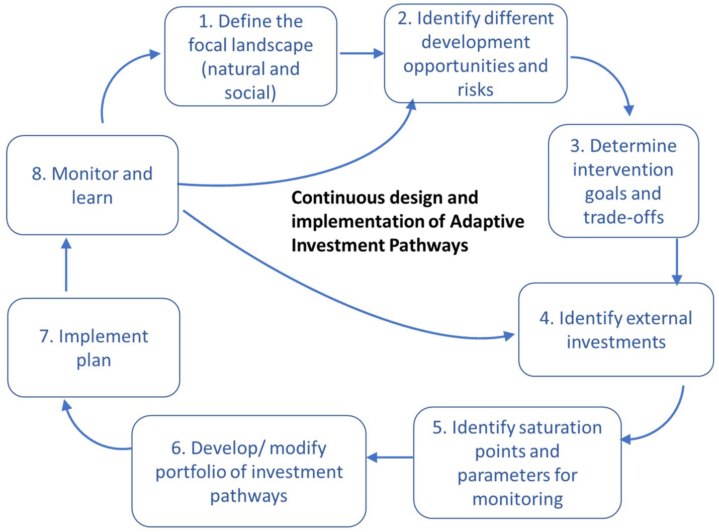
Figure 1. Steps to implement AdIP (Source: Prasad et al., 2023).
It is well documented that there is flourishing small-scale irrigation development in many parts of Africa that is farmer-initiated (Woodhouse et al., 2017) that is making significant contribution to the food and livelihood security of the region with very little external investments (De Fraiture and Giordano, 2014; Wiggins and Lankford, 2019). Faced by high levels of uncertainty, farmers are forced to be adaptive and to keep their options open. They make small incremental investments as they learn from their experiences, take advantage of opportunities as they come by, and step back or reorient when necessary, for instance, when faced by unexpected challenges. At the same time, there is a risk that the un-coordinated actions by individual farmers may result in unsustainable and inequitable use of natural resources, resulting in maladaptation. Our focus is the development of irrigation along ephemeral sand rivers, which form a reliable and accessible source of water for small-scale irrigation in semi-arid to arid regions of SSA. These sand rivers play an important role in climate adaptation in the drylands by virtue of providing shallow nature-based water storage.
Our three case studies are in landscapes where we have been engaged in research projects and action research. The case studies represent different stages in irrigation development and investments along sand rivers. We study them retrospectively to illustrate different types of risks encountered, the type of external investments and policies made by government programs and other actors, the response of farmers to external risks and investments in terms of their own decisions, and the overall state of irrigation development in the landscape. The Olkeriai river basin in Kajiado county of Kenya is a case where informal farmer-led irrigation has developed rapidly in a traditionally pastoral land in the past two decades, in part due to triggers such as individualisation of land titles, construction of a tarmac road easing access to markets and the in-flow of external factors such as investing “tajiris” and migrant farmers (Karimba et al., 2022). The second case is the Enguli river basin in Makueni county, Kenya, where livelihoods based on the sand river were destroyed by extensive sand harvesting by external sand cartels. After a violent struggle and collective action from community members, the local administration introduced sand harvesting regulations, promoted campaigns for awareness building, and investments in sand-dams which led to a gradual rehabilitation of the river and consequently, of irrigation-based livelihoods. The third case is the Shashane river near Tshelanyemba, Matobo district, located in one of the driest and poorest provinces of Zimbabwe. This represents a case where despite farmers’ aspirations for scaling, endogenous irrigation has not scaled beyond bucket-irrigation of gardens using water drawn from hand-made scoop holes in the sand river bed (Chauruka et al., 2023). Through these distinct case studies, we seek to reflect on the implications for AdIP, e.g., in terms of types of investments made, role of different actors in investment decisions, scales of investments, unforeseen risks encountered as well as the nature of saturation points (Prasad et al., 2023).
In the next section we describe the AdIP approach which is the lens we use to analyse the three case studies, followed by a description of the case study locations and the data collection methods. We then present the results in terms of a retrospective view of livelihood trajectories, irrigation investments and saturation points found in our study areas. Presentation of the findings is followed by a discussion of the implications of the findings for AdIP and the outlook on the way forward.
2 Conceptual framework: adaptive investments pathways
AdIP is an approach to guide adaptive planning of investments towards specific development goals. A conceptual framework for AdIP is presented in Figure 2 using the context of sand river based smallholder irrigation development. Here, the AdIP approach aims to guide planning external investments adaptively to support and supplement in-situ investments made by farmers and local communities themselves. While farmers invest in their own farming practices at the farm-level, various “external” actors, such as government departments, NGOs, development agencies, local institutions or the private sector, also play a role in planning and making investments at the landscape scale to achieve irrigation development objectives. There is thus, a feedback between farm scale and landscape scale interventions, which makes for an adaptive and participatory approach to irrigation development. This stands in contrast to the centralized top-down planning of big irrigation projects.
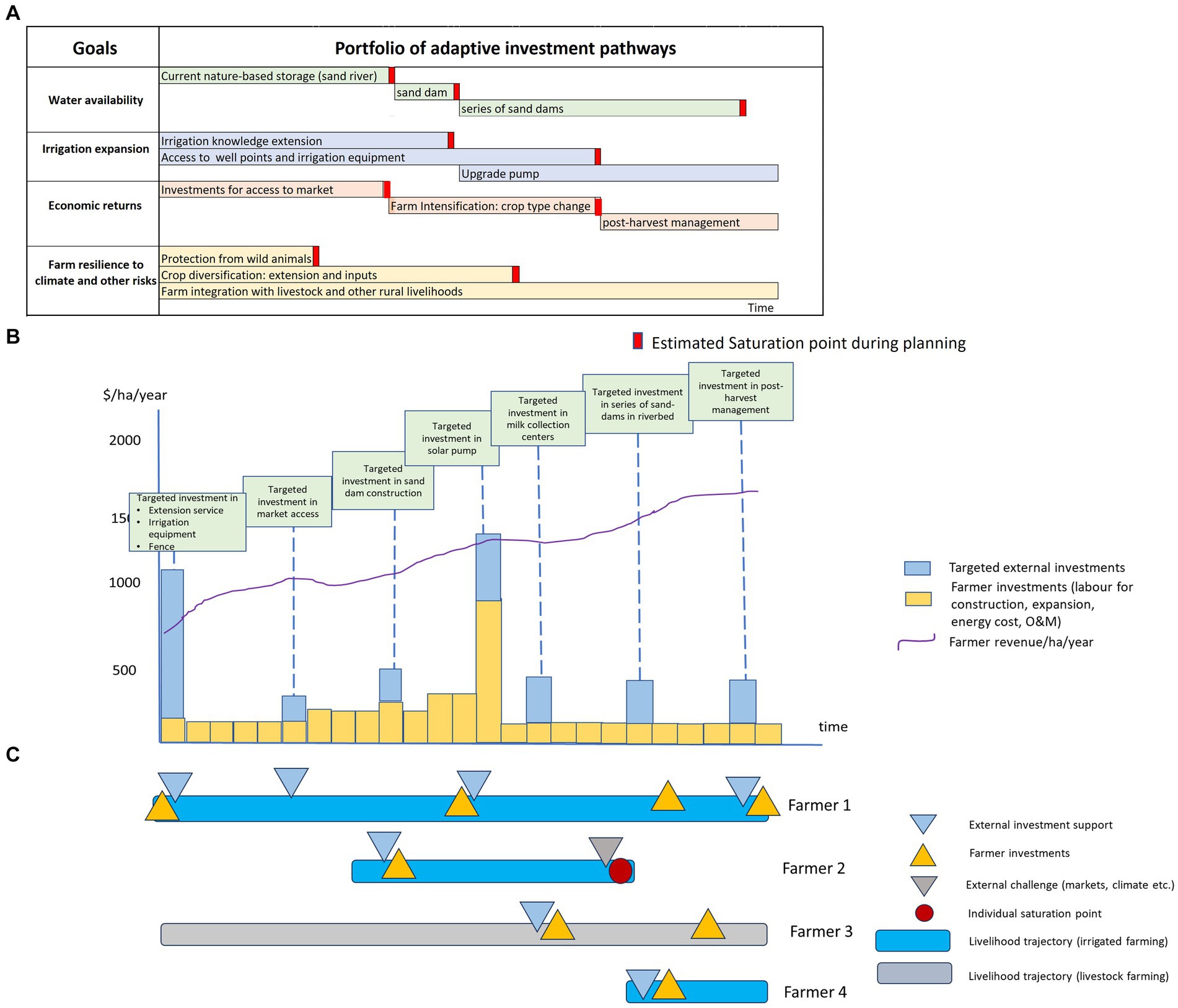
Figure 2. Stylised representation of (A) a possible AdIP plan for external investments, (B) implementation of adaptive plan, and (C) possible livelihood trajectories of different farmers in response to external investments and risks (adapted from Prasad et al., 2023).
Figure 2A shows an AdIP plan which is a portfolio of potential incremental investments at the landscape scale designed to achieve jointly developed objectives. Such a plan is co-developed and iteratively revised over time as new information about risks and opportunities becomes available. The precise nature of investment and its schedule of implementation is not known with certainty at the time of planning. The schedule of implementation depends on how soon the landscape starts approaching saturation points. Hence, monitoring the landscape for approaching saturation points is a key concept of AdIP.
Saturation points are points in time when certain biophysical or socio-political conditions (such as resource related conflicts) are reached, which limit further progress towards the development objective. Additional investments or interventions are then needed to make further progress towards the objective. AdIP uses the term “saturation point” as opposed to “tipping point” used in DAPP (Haasnoot et al., 2013). Tipping point indicates an inevitable transition of the system to an altered state, but in the context of AdIP, it is possible that the system remains stable (and in some cases desirably so to remain sustainable) at the existing level of development even when the current investments no longer drive further irrigation development.
During the planning stage, potential saturation points are identified together in a participatory manner with stakeholders within the landscape and a monitoring framework is developed and implemented. The monitoring framework itself is not static and is updated over time. With learning from the monitoring, new potential saturation points may be identified and monitored.
Figure 2B shows a view of one possible way in which the AdIP plan may turn out during implementation in the form of targeted external investments at the landscape scale supplementing farmers’ own investments. Figure 2C illustrates farm-level livelihood trajectories over time resulting from different farmers’ decisions in response to external landscape scale investments and risks or opportunities. An investment by the farmer here refers to investments in irrigation hardware (land, wells, pumps, pipes, storage tank), related investments in farming practice (e.g., land preparation, inputs, fence) and also in softer aspects of investments (e.g., knowledge, partnerships, contracts, leasing or renting equipment). Investments may also be related to other sources of livelihoods which may indirectly relate to irrigation, e.g., shifting from traditional variety to stall-fed dairy cattle (which may allow a focus on irrigation), purchasing livestock (which may later be sold to purchase inputs), starting a new business, etc. Farm scale decisions may be in response to farmers’ own sense of farm-level variables which may be (implicitly) monitored by the farmer (e.g., water availability, access to capital, input costs, market prices, perceived benefits and risks etc.). Farm scale investments are thus farmer-led, which are likely to respond to landscape scale attributes.
In order to draw lessons for operationalizing AdIP, we conduct a retrospective analysis of how small-scale irrigation has developed in three different landscapes with high biophysical, socio-economic and political risks. In each of these three landscapes, we reconstruct farmer trajectories (along the lines of Figure 2C) and analyse these to relate farmer decisions to risks and external investments, thereby drawing implications for AdIP.
3 Case study areas
This section describes the characteristics and context of irrigation development in our three case study areas, which is also summarized in Table 1.
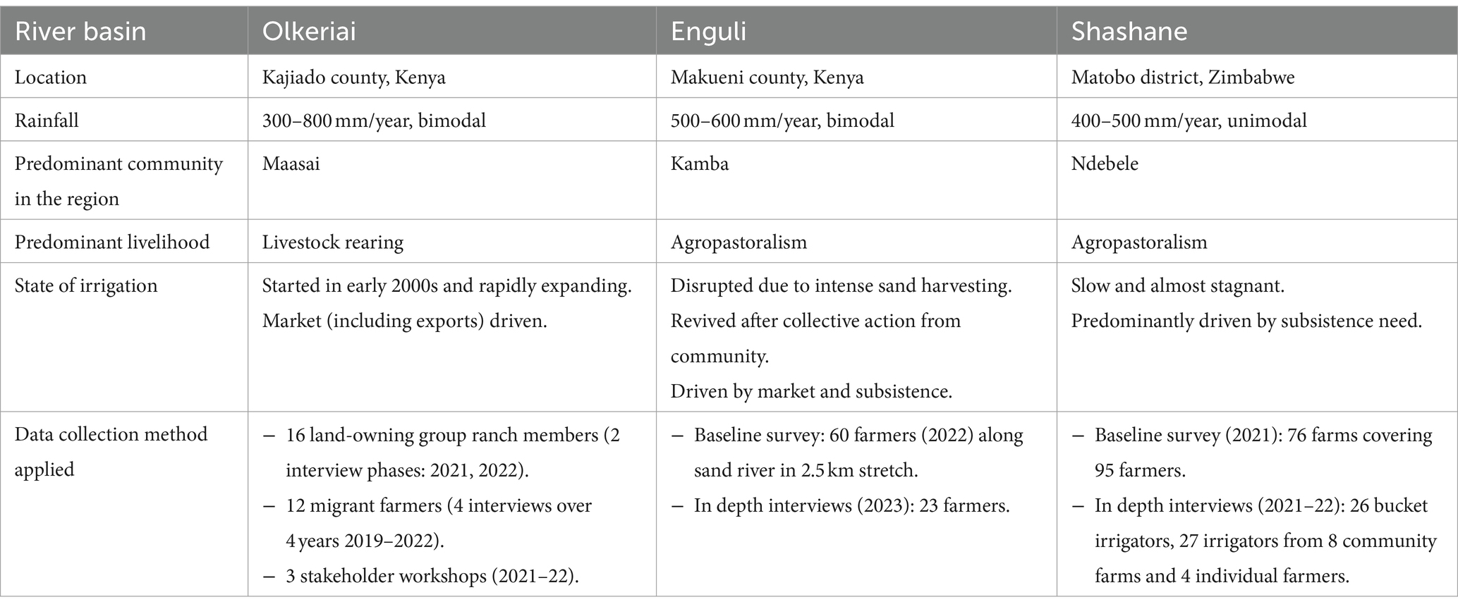
Table 1. Summary of field sites and data collection methods.
3.1 Olkeriai river basin, Kajiado county, Kenya
The Olkeriai river catchment of southern Kajiado county, Kenya, is a semi-arid region with average rainfall between 300 to 800 mm/year that follows a bimodal pattern. The region has been traditionally inhabited by the pastoralist Maasai. The Land (Group Representative) Act was enacted in 1968 as a result of which the Maasai land was divided into Group Ranches (GR) (Rutten, 1995). Within 15 years many group ranches decided to sub-divide and individualize land titles amongst members. The Mashuuru GR, the largest group ranch within the Olkeriai basin, started subdivision in 1998, and as a result each member received roughly 170 acres of land. The formal issuance of titles took almost two decades due to various conflicts and litigations. Irrigation along the Olkeriai river started to expand in the first decade of 2000, and accelerated from 2010 onwards with the arrival of migrant farmers and entrepreneurial capital providers called tajiris (Karimba et al., 2022) from neighbouring regions who developed diverse irrigation partnership arrangements. These partnerships form the most prevalent irrigation arrangement in the area. The completion of the tarmac road connecting Mashuuru to Nairobi further stimulated irrigation within the catchment. Although livestock keeping continues to be the primary livelihood activity, irrigation has emerged as an important economic activity (McCabe et al., 2010; Archambault et al., 2014).
3.2 Enguli river basin, Makueni county, Kenya
The Enguli river basin lies in Makueni county of southern Kenya, just North of Kajiado county. It receives 500–600 mm/year rainfall in a bimodal rainfall pattern. The region comprises predominantly members of the Kamba group, who have traditionally been agropastoral, hence agriculture and livestock keeping are important livelihood activities. The basin has been used by the riparian communities for small-scale irrigation for a long time. However, this irrigation activity was adversely impacted during an unexpected phase of turbulence. Starting around 2010, there was destructive sand harvesting in the river which led to a deadly conflict in the region. Farmers could no longer access water as sand harvesting led to loss of sand and hence, loss of water stored in this sand. Riparian farms were also destroyed by sand lorries as they approached the river. Several residents fled the area due to high levels of insecurity. Joint efforts by the community and the local government eventually ended the conflict around 2016 and helped in the rehabilitation of the sand river through construction of multiple sand-dams (Velasquez et al., n.d.). This led to a gradual revival of irrigation and other livelihood opportunities in the region.
3.3 Shashane river, Matabo district, Zimbabwe
The Shashane sand river is in Matobo district of Zimbabwe’s Matabeleland South Province. It is a significant tributary of the Shashe river, which flows into the Limpopo river. The study area experiences a unimodal rainfall pattern averaging 450 mm/year. Our focus is a 7.2 km river stretch of the Shashane river near Tshelanyemba town. The majority of the people within the region is of Ndebele origin. The community is agropastoral, with livestock keeping being an important source of livelihood accompanied by rainfed farming. The poverty rate is very high and the study area lies within a province which itself is one of driest and poorest in Zimbabwe. Irrigation along Shashane in our study area has characteristics that are very different from the first two case studies. Due to the state of Zimbabwe’s economy and the lack of economic opportunities, there is significant migration of men, and the youth in particular, across the nearby border to South Africa and, as a result women play an important role in farming activities. Different types of irrigation have emerged along the Shashane river (Chauruka et al., 2023): bucket irrigation gardens (farming households that fetch water with buckets from the river to irrigate very small portions of land, less than 0.1 ha); small community irrigation schemes (a group of irrigators jointly operating an irrigated area of 0.5 ha or less, either irrigating manually or with pumps, with some shared assets such as common fence and possibly a pumping system); and a few “individual irrigators” (irrigating plots that are larger than 0.1 ha with fuel- or solar-powered pumps). However, unlike the other two case study sites where there is dynamic irrigation development, Tshelanyemba illustrates the case where irrigation development is slow, or almost stagnant. Here, starting 2017, an action research project called A4labs1 was initiated to trigger smallholder irrigation along the river.
4 Data collection methods
Our primary case study is the Olkeriai river basin in Kenya where we have conducted in-depth longitudinal studies. We supplement this with shorter, more focused field studies in the Enguli and Shashane basins to capture some important differences. In this section we describe the data collection methods used in each of the case study locations. A summary is presented in Table 1.
4.1 Olkeriai basin
Primary field work was conducted in the Olkeriai basin between 2019 and 2022 (Duker et al., 2022, 2023; Karimba et al., 2022). Here, we present results from field work conducted with two distinct groups: a group of land owners with diverse livelihoods, and a group of migrant farmers who irrigate in partnerships with land owners and other actors.
With the first group, we conduct a retrospective study to understand the investment decisions made by land owners and their relation with external investments or triggers, which contributed to the development of irrigation along the Olkeriai river. A related goal is to understand the impact of irrigation on other livelihood choices such as livestock keeping, the traditional livelihood of the Maasai. To study this, we sample 16 land owning members, who have lived in the (now subdivided) Mashuuru group ranch for at least the past 10 years, whether or not they currently pursue irrigation. Our purposive sample captures diverse livelihood choices, and covers a geographical spread within the GR, including members who live away from the river.
With the second group of migrant farmers, we focus on irrigation investments and trajectories of 12 migrant farmers who practice irrigation along the Olkeriai, by leasing land and/or engaging in short-term partnership arrangements with many actors, including land owning residents described above. The migrant farmers are typically not Maasai but belong to other ethnic groups from neighbouring counties. They have a very dynamic and flexible practice in which they get into short term market-oriented irrigation ventures and find security in the flexibility that such mobility offers. These farmers are also discussed in Duker et al. (2022, 2023).
Two rounds of detailed interviews were conducted with land owners, first in 2021 (remotely through local research assistants during Covid travel restrictions), and a second time in 2022 (in situ). The study with migrant farmers involved multiple rounds of interviews – a baseline and in-depth survey in 2019, follow up (remotely organized) interviews in 2021 and in situ interviews in 2022. In addition, we conducted three workshops in the study area with local community members in order to: (a) construct a participatory historic timeline of the evolution of livelihoods and the related investments within the Mashuuru GR (in September 2021 with 20 participants), (b) discuss opportunities and risks associated with irrigation development for group ranch members pursuing diverse livelihoods (in September 2021 with 22 participants), and (c) understand the perspective of participants on the sustainability of the current practice of irrigation and the presence of any limits to sustainability (January 2022, 17 participants).
4.2 Enguli basin
Primary field work was conducted in the Enguli basin in two phases – an exploratory phase in September 2022 and then more intensive field work from December 2022 to January 2023. This involved a baseline survey of all irrigation activity along a 2.5 km stretch of the river, and a set of deeper interviews with 23 selected farmers. The objective was to retrospectively capture the irrigation decisions of farmers within their broader livelihood trajectories and the relation of these decisions to external triggers such as the sand harvesting related conflict.
4.3 Shashane basin
Primary field work was conducted in two rounds in 2021 and 2022. This involved a baseline study of the different types of irrigation practices followed along the Shashane in the selected area. This study found 64 bucket irrigated gardens, 8 community gardens, two of which were started as part of the A4labs action research project, and 4 individually irrigated farms. Semi-structured interviews were then held with 26 out of 64 bucket-irrigated farmers (Chauruka et al., 2023), all 27 irrigators involved in the 8 community gardens (including A4 labs), and all 4 of the individual irrigators. The objective of the study was to understand the nature of irrigation, its impact on livelihoods, and the future outlook of the farmers.
5 Results
In this section we present our findings from the three case studies. In Olkeriai and Enguli basins, where there is thriving irrigation, we describe the evolution of livelihood trajectories in the context of investments made in response to risks and opportunities. In the Shashane, we do not observe dynamic livelihood trajectories, hence we present the results in terms of the risks and opportunities faced by the irrigators. Figures 3, 4 trace the livelihood trajectories of 16 land owners and migrant farmers, respectively, in the Olkeriai basin. For the land owners, a significant trigger impacting livelihoods was the sub-division of the group ranch and individualisation of land ownership. Some of the respondents received land that was located close to the river (9 out of 16), while others received land away from the river (5 of 16). In contrast, the migrant farmers move from season to season, hence the irrigation investments and trajectories associated them are not tied to a static plot but are spread across multiple plots within the study region. Figure 5 presents the trajectories of Enguli farmers and investments in face of unexpected events.
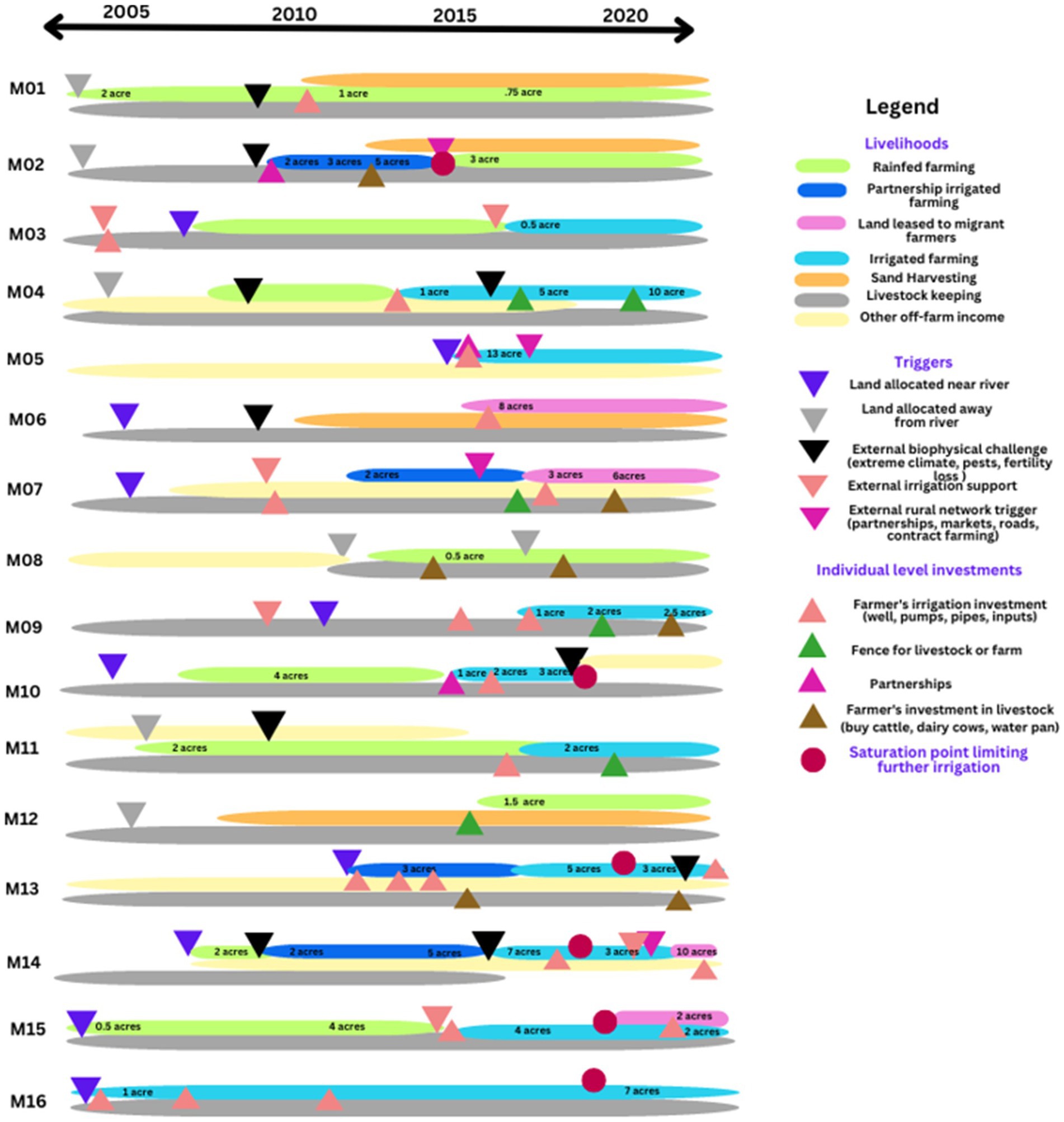
Figure 3. Olkeriai basin, Kajiado county, Kenya: Livelihood trajectories of landowners (M01…M16 represent individual farmers).
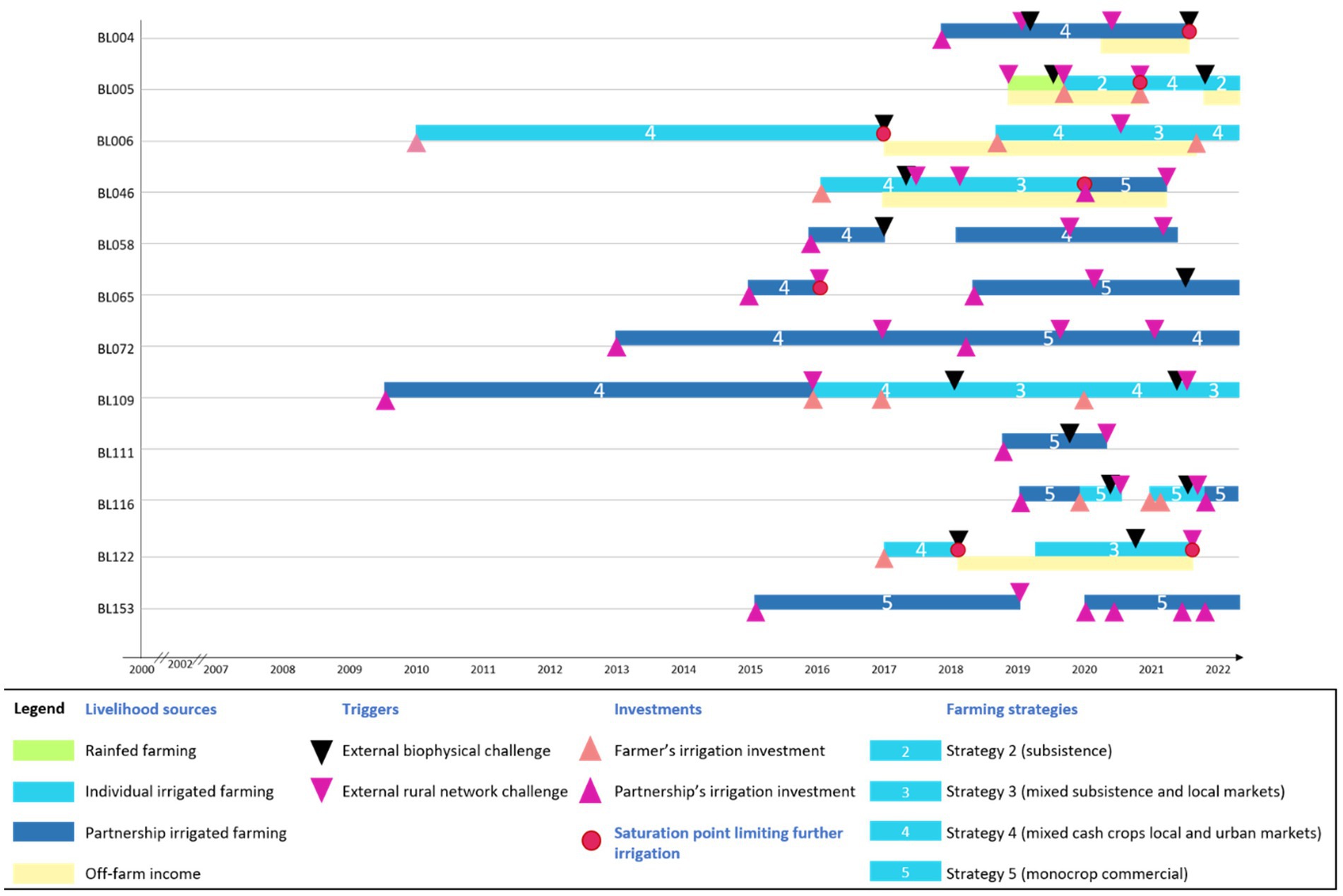
Figure 4. Olkeriai basin, Kajiado county Kenya: Irrigation trajectories of migrant farmers (BL004…BL153 represent individual migrant farmers).
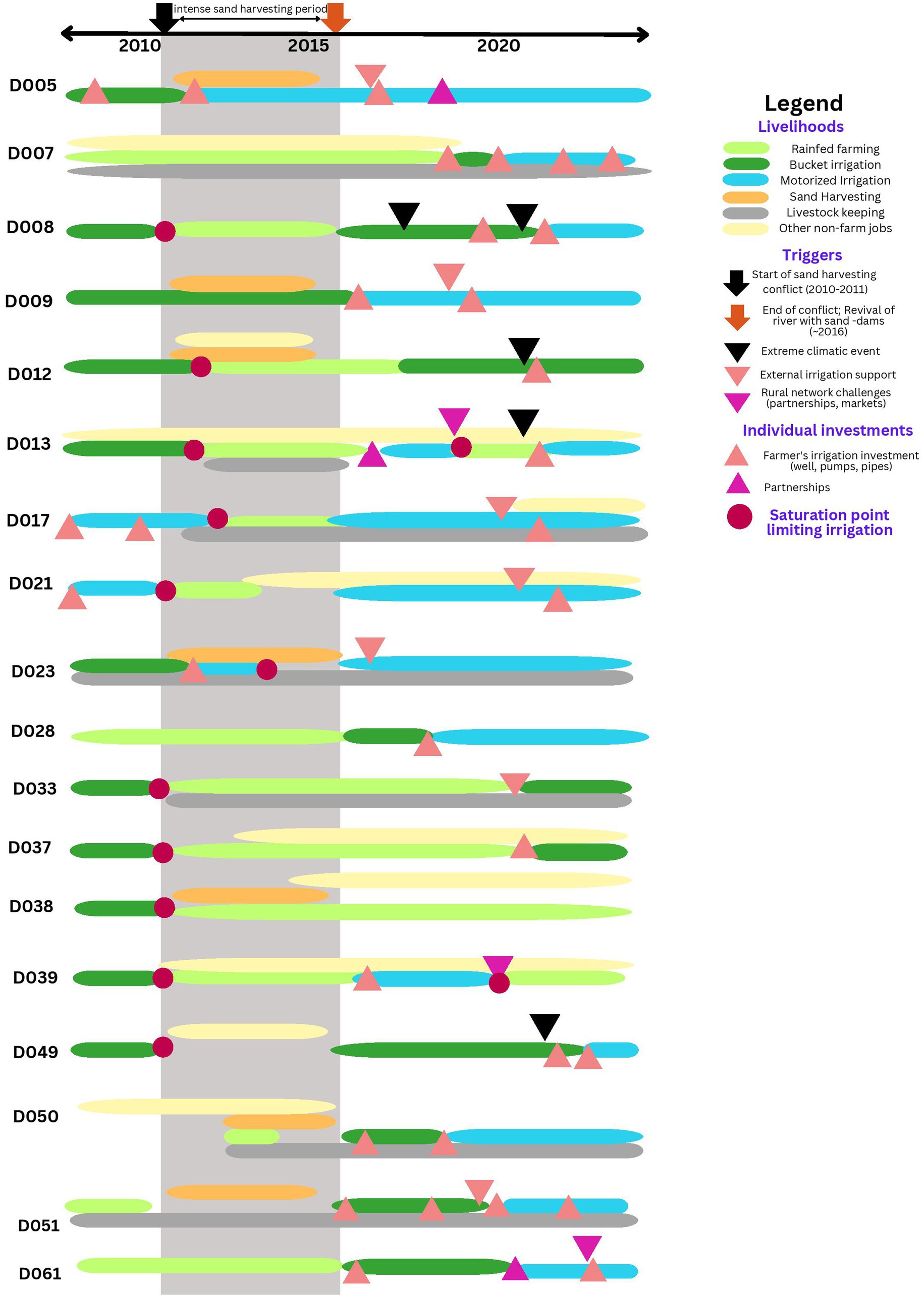
Figure 5. Enguli farmer trajectories (D005…D061 represent individual farmers).
In the following sections, we highlight our main findings across the three case studies. These show that irrigation investments are not stand alone, but interconnected with other livelihood choices; external opportunities and risks trigger farm scale investments, which, in the face of uncertainty, are incremental in nature; farmers may pause or reorient their investments when certain biophysical or socio-political limits or saturation points are encountered; these saturation points may be addressed through external landscape scale interventions which in turn facilitate farm-scale investments, but this may not always happen especially when the basic livelihood needs of the communities are yet to be met.
5.1 Irrigation as part of diverse interconnected livelihoods
Farmers pursue multiple livelihood strategies simultaneously, which usually support one another. In case of landowners in Olkeriai (Figure 3), livestock keeping is the predominant source of livelihood for all respondents. Farming is conducted in different ways: rainfed farming, irrigated farming individually on own land, irrigated farming through profit sharing partnerships, and leasing own lands to others for irrigation in return for a fee. Sand harvesting is another important economic activity besides others, such as running local businesses, milk selling, brick making, tailoring, formal jobs, or renting out commercial properties, etc. Investments in livelihoods are interconnected. For example, the Maasai often sell cattle to make an irrigation investment such as digging a well or buying water pumps (M04, M07, and M09). Conversely, they may actively engage in irrigation to recover from the loss of livestock after a drought, in order to gradually rebuild their stock of cattle through farm income (e.g., M02, M07, and M14). Similarly, some lease their land to migrant farmers with the objective of raising capital to invest in their own farm (e.g., M07 saved to purchase a solar pump) or to invest in cattle (M06).
Compared to the landowning farmers, the migrant farmers in the Olkeriai basin (Figure 4) are more focused on irrigation as their primary livelihood activity, but they remain flexible, and get in and out of irrigation depending on their other livelihood interests and opportunities. Their farming strategies include producing primarily for household consumption (strategy 2), producing for subsistence and local markets (strategy 3), cultivating diverse cash crops for urban markets (strategy 4) or growing a mono crop in a commercial venture (strategy 5).
Diversification of livelihoods is seen also in the agropastoral community of Enguli basin, where farmers pursue livestock keeping, rainfed farming, manual irrigation through buckets, motorized irrigation, sand harvesting and other livelihoods (Figure 5). Investments in livelihoods are interconnected as seen also in the Olkeriai basin.
In the case of Shashane, farmers practice diverse livelihoods, but the level of interconnection is limited, especially for the poorest of farmers. For example, the bucket irrigators of Shashane also rear livestock which can act as capital towards procuring irrigation equipment such as a pump. However, they remain reluctant to sell livestock to invest in irrigation and prefer to save them for emergencies. This is the believed even though marketing is not a problem since local people are always in need of vegetable produce, nor is the availability of water in the sand river considered a constraint. According to the farmers, selling livestock generates instant cash for emergencies, which irrigation does not. Hence, given the highly uncertain environment (in terms of both biophysical and socio-economic aspect), livestock is seen as an essential life insurance compared to irrigation development. Some farmers indicate that if they had a pump and fencing materials, an irrigated plot of 1,000 to 2,000 m2 would be feasible and would have the capability of transforming their livelihoods, but this is not something in which they invest themselves through their limited assets.
In the case of Shashane’s community garden farmers, all the interviewed farmers were involved in rainfed farming, livestock keeping, poultry rearing as well as collecting mopane worms for sale. Some also received remittances from neighbouring South Africa. The farmers used their farm income to meet diverse but immediate family needs. For example, two women used the farm income to build their homesteads, a few bought goats and sheep, one farmer bought a sewing machine from the tomato sales and diversified into tailoring. Three farmers bought bicycles using the farm returns and the majority said that travelling had become easier as they now had the money to use public transport. One farmer was able to provide medical care to her husband using her farm income while two women highlighted their reduced dependence on remittances. Farm incomes were thus reinvested but rarely back into farming.
In contrast, the four individual irrigators interviewed in Shashane basin all developed their gardens with no external support. They use water from the sand river to irrigate gardens ranging from 1,000 to 4,000 m2 using pumps (fuel powered or solar powered). Three of the four are employed in the formal sector and view irrigation as a supplementary activity. All four have multiple sources of income and also engage in other livelihood activities such as rainfed farming, livestock keeping, poultry, collection of mopane worms and one is also engaged in fish rearing. Two of them sold their livestock to generate cash for investing in irrigation. Two took formal loans which were guaranteed through formal employment. The farmers use the farm incomes in a variety of ways, including re-investment in their farms. One has invested the returns in renovating his homestead and installing a solar-power generator for household use. Another farmer shifted from fuel powered pump to a solar-powered pump for irrigation. One farmer was able to invest in fish farming from selling tomatoes. He also purchased a grinding mill and started a business to mill maize. He has employed two permanent workers on his farm, in addition to one at the grinding mill. All four farmers aim to continuously expand their gardens by gradually bringing more of their rainfed farms into irrigation.
5.2 External risks and opportunities as triggers for farm-level investments
Farmers face and respond to many external triggers (triangles facing down in Figures 3–5) which may be in the form of risks or opportunities. First, biophysical risks (black face-down triangles in Figures 3–5) are important triggers for new investments by farmers, although in some cases prolonged exposure to such risk could result in farmers pausing farm operations or stepping back. As observed amongst landowning farmers of Olkeriai (Figure 3), drought is a frequent risk. This may trigger rainfed farmers to shift to irrigation (M14). Other biophysical triggers include: human-wildlife conflict triggering investment in fencing (M04), floods sweeping away riparian farm lands and irrigation equipment resulting in exit from irrigation (M10), Covid impact on businesses leading to more focus on irrigation (M13), and water shortage in shallow wells impacting irrigation (M15, M16 in an upstream part of the group ranch). Pest attacks occur frequently too and impact farmer’s viability to continue irrigation.
Second, in terms of opportunities, external investments or support for irrigation (light pink face-down triangle) are triggers for farmers to make their own investments in irrigation. Farmer M09 decided to irrigate after water availability was improved due to the construction of a sand-dam in the stream by a donor organization. He gradually reduced his cattle stock and invested in a shallow well and water pump along the stream. He now identifies his primary occupation to be irrigated farming. Other examples include donor or government support subsidizing farmer investments in wells (M03 and M07), drip systems (M14) or pumping systems (M03).
Third, there are triggers for investments which are related to challenges and opportunities presented by rural networks (dark pink face-down triangles), i.e., partnerships (M14) in which the lessee makes investments such as shallow wells in the land owners farm, markets which may incentivize cropping intensification or de-intensification (M02 and M10), contract farming opportunities for export market (M05, M07, and M14) and related infrastructure such as roads, milk collection centres etc.
The above is also seen in case of migrant farmers of Olkeriai (Figure 4) for whom triggers to alter strategy include both risks and opportunities: biophysical aspects such as failed harvests due to floods or pests, dynamics in the rural network like market volatility or priorities to invest in other livelihood sources, and personal matters such as family health problems.
5.3 Under uncertainty, investments are incremental
Irrigation is not a traditional livelihood for the Maasai, and we rarely find a case in the Olkeriai where irrigation is initiated with a big investment. Exceptions to this are M05 and M11 (Figure 3) who were both employed outside the group ranch for years and diversified into irrigation by making lumpsum investment using savings from their primary income source. Most farmers venture into irrigation through incremental investments (upwards facing triangles in Figure 3). Irrigation along the sand river typically begins simply with the help of (no-regret) dug-out scoop holes and cheap petrol pumps (M10 and M14). Since scoop holes get washed away with every flood event, at some point farmers may decide to invest in shallow wells along the bank of the river or in-field. They may decide to purchase more expensive and powerful diesel pumps, or in some cases a solar pump (M07 and M13). Other investments include fences for farms or for pastures (green triangles). Fencing can be a formidable challenge for some as it requires frequent collection of brushwood branches, and over time farmers aspire to invest in the more reliable, though expensive, wire fencing. Farmers also increase their investments by gradually expanding their irrigated area or by intensifying their cropping pattern. Maize and beans are the most common low-risk crops (used for both human and livestock consumption), often combined with small portions of vegetables. When farmers intensify, they expand the area under vegetables and invest in producing cash crops that demand high inputs such as tomatoes and watermelons. More recently, contract farming companies have started engaging farmers in contracts for export quality French bean production. Intensification leads to significant increase in inputs, especially chemical-inputs such as pesticides and fertilizers. Investments in irrigation are often accompanied also by investments in livestock (brown triangles) in terms of newer varieties, water pans or borewells for livestock watering, etc. As farmers divert more time and resources such as land and water to irrigation activity, some choose to reduce their livestock and/or to move to stall-fed dairy cows.
Landowning farmers lower their risk by investing in partnership arrangements (dark pink upwards facing triangles in Figure 3). These arrangements reduce their burden of raising capital for inputs and allow them the opportunity to gain knowledge from their partners, who are typically experienced migrant farmers. After a few years of partnership and learning the ropes, the land owners may start irrigation independently (M07, M10, M13, and M14). On the other hand, migrant farmers also lower their farming risks by entering into short-term partnerships with land-owners. Partnerships with tajiris allow migrant farmers to further reduce their risk exposure.
Migrant farmers who lease land from Maasai land owners mostly invest in partnerships with a tajiri (capital investor, see also Karimba et al., 2022), who provide the necessary monetary capital and thereby reduce the risk for the farmer. The flexible partnerships and technology allow for this adaptive nature of irrigation development, which avoids lock-ins.
5.4 Farmer investments may pause or scale back due to personal limits or landscape level saturation points
In some cases, farmers have reached a point where they pause or step back from irrigation. This may be deliberate or due to a resource limitation. In the case of landowning farmers of Olkeriai, M15 and M16 face insufficient water availability which they attribute to intensive sand harvesting along their farm. This limits their ability to keep up the levels of irrigation. In the case of M13 and M14, loss of soil fertility from years of input-intensive tomato monocropping has triggered them to de-intensify and reduce irrigated area. Biophysical limitations appear to be the main reasons (if any) for riparian landowning farmers to pause or step back their irrigation activities. Access to capital is usually not a constraint for them due to multiple options such as selling livestock, temporarily leasing land, partnering with migrant farmers etc.
In case of the migrant farmers (Figure 4), irrigation may be paused or scaled back when they become unable to further invest due to a lack of access to necessary production factors (such as finance, technology, and labour). The causes can be biophysical and socioeconomic in nature, for example, the inability to purchase a pump (BL005), (consecutive) failed harvests (BL006 and BL122), conflicts with farm partners (BL065), destruction of crops by livestock (BL004), and in several cases a combination of events such as a flood, pests, marketing challenges, and/or family health problems (BL046 and BL122) leading to the inability to further invest in irrigated farming. In the case of the migrant farmers (unlike the landowning farmers), the individual saturation points rarely represent landscape level biophysical saturation points, but instead often boil down to insufficient capital. In fact, most migrant farmers avoid landscape level problems like water scarcity or land degradation by moving to new plots with assured soil fertility and water availability.
A similar phenomenon is seen with the bucket irrigators of Shashane. Bucket irrigation is highly labour intensive because even a 100 m2 garden requires 30 trips to the river per day to irrigate the garden using a 20 Liter bucket. Therefore, this mode of irrigation cannot support larger sized gardens. At the same time, this size of farm does not produce sufficient surplus to expand the farm and/or invest in a fence or pump. Hence, we find that although a great majority (81%) of bucket irrigators aspire to expand their existing irrigated fields, they are saturated at a point where they cannot expand irrigation due to lack of finance (Chauruka et al., 2023).
The case of farmers in the Enguli basin shows farmers’ response to an unforeseen shock in the form of intensive sand harvesting. Before sand harvesting began in the study region in 2010, a large number of farmers practiced small scale irrigation manually using buckets for drawing water from scoop holes in the river bed. As sand harvesting intensified, an unforeseen landscape level saturation point emerged in the form of a rapid drop in water level in the riverbed. As a result, it became increasingly difficult for farmers to irrigate manually. In some cases (Figure 5), this led to farmers abandoning irrigation altogether, while in others, it led to farmers investing in wells and pumps (D005, D023) in order to reach deeper into the (shallow) aquifer. During the phase of intense sand harvesting farmers diversified to other sources of livelihoods, some actively engaging in sand harvesting themselves (D005, D009, D023, D038, D050, and D051), others pursuing rainfed farming on plots away from the river (D008, D012, D013, D017, D021, D033, D037, D038, and D039), or livestock keeping (D007, D013, D017, D033, and D050), or moving to cities to take up different jobs (D007, D049).
5.5 Saturation points may be addressed through external investments which then catalyze farm-scale investments
In the case of the Enguli basin, after the sand harvesting was halted with the efforts of the local community and local government, restoration works were done on the river through the construction of multiple sand dams. By 2016, the sand level (and with it the water level) started to rise again. This led to the farmers returning back to irrigation. Some re-started bucket irrigation while some others invested in wells, pumps and pipes (Figure 5). Some external triggers that helped to catalyze this was government support programs that partly finance seeds and inputs (D017), bank loans or subsidies (D023 and D033) and technical support from agricultural extension officers (D017, D021). Over time, private companies found it attractive to start working with farmers by offering creative financing modalities and technical assistance which some farmers have taken advantage of to access solar pumps (D051) and farm inputs (D009).
5.6 When external investments do not trigger individual investments
In contrast to the above example of Enguli, in the case of Shashane we find the opposite, i.e., the case where external investments did not trigger farm-scale investments. Community gardens were started in Shashane study area by the NGO Dabane Water Works (DWW). Within a common fenced area of about 5,000 m2 created by farmers through their own labour, multiple farm plots were created (60 to 105 m2 each) and operated by multiple community members (ranging from 8 to 43 members per community garden). DWW provided farmers with trainings. It also provided the community gardens with an irrigation system to pump water from the sand river into reservoirs built in the gardens from which farmers could irrigate using buckets. The gardens function as a collective where all farmers within a garden grow the same crops in rotation. Women dominate the community gardens, with 17 of the 18 interviewed irrigators within the DWW community gardens being women. They produce for both household consumption and for local sales to generate income. Although all interviewed farmers indicate the desire to expand their current irrigated farms, there is no plan as a community on how to contribute towards this. Instead, farmers look forward to external assistance to enable expansion. A significant issue thus seen in the community gardens is problems related to lack of entrepreneurial initiative regarding expansion, operation, and maintenance of the irrigation systems. In one of the community gardens, farmers failed to repair their pump after it broke down, also pointing to lack of collective planning and ownership. This is also seen in the fact that there are no known instances of farmers starting their own (larger) farm after having generated some savings from the community gardens.
The two A4labs community gardens in the same region had a little different approach. Here, the gardens were shared with fewer number of irrigators (one with 3 farmers which later dropped to 2, and the second with 7 farmers), each farmer operating comparatively larger plots of 1,400 to 2,500 m2. Moreover, technically advanced irrigation systems based on solar pumps (and drip irrigation in one of the two gardens) were provided by the A4labs project to enable irrigation of larger plots with the potential to produce more output. Farmers from the two A4labs gardens engaged in other livelihood strategies but found that irrigation demanded much of their time but yielded better returns compared to other options such as engaging in casual labour jobs. Farmers re-invested farm income into diverse needs. One farmer built a modern kitchen, one bought a goat from the income, one is saving to build a homestead, another has been putting monthly savings in a savings club that she is a member of, many indicated the ability to pay children’s school fee and one farmer managed to send their child to boarding school relying on the farm income. Most farmers from the A4labs project (6 of the 7 interviewed) aspire to have their own individual irrigated farms closer to their homesteads, while one wants to remain within a community garden. However, so far there is no evidence of such investment in expansion by any of the farmers.
6 Discussion: implications for AdIP
Many lessons emerge from the three case studies. Based on this, we discuss the implications for AdIP, specifically on the nature and scale of investments under AdIP, the saturation points and their identification, and the monitoring plan.
As seen from the case studies, investments in irrigation may be viewed at two nested scales – the farm scale and the “landscape” scale. At each scale, different actors and decision makers are involved. The landscape refers not only to the geographic biophysical landscape within which irrigation develops, but also to the social landscape which comprises different actors who participate, influence or are impacted by irrigation development. At the farm level, trajectories are driven by farmers’ (and farming partners’) decisions which depend upon their access to different capitals, their motivation, other livelihood opportunities etc. At the landscape scale, irrigation is facilitated by technology, access to markets, knowledge, capital, infrastructure and related services through institutions and partner networks.
The AdIP is concerned with planning landscape-scale investments which are beyond the capacity of individual farmers, and which may be implemented by external institutions, government, local NGOs and development agencies in order to facilitate farm-scale irrigation development. There is feedback between the scales, such that landscape scale investments influence irrigation development at farm level by addressing bottlenecks and creating a facilitating environment, and irrigation development at the farm scale in turn creates the need for landscape scale interventions when saturation points emerge. In this way, AdIP is distinct from the traditional supply driven approaches to irrigation development (de Bont, 2018; de Bont and Veldwisch, 2020) which are implemented in a top-down manner with farmers being considered as beneficiaries of the scheme. At the same time, AdIP is also distinct from the demand-driven pull-based approach, for example as promoted by the World Bank (Izzi et al., 2021), which aims to facilitate farmer-led irrigation at farm scale but does not account for landscape scale attributes such as resource thresholds and socio-economic limits to sustainable and equitable resource use.
Since irrigation is closely interlinked with other livelihoods, e.g., through cash flows and hedging of risks, development of resilient irrigation practice requires a systems thinking approach (Mahajan et al., 2019) to strengthen these interconnections and avoid unintended consequences. This implies that interventions are planned in a way that not only directly support irrigation investments but also support investments in allied livelihoods which indirectly strengthen irrigation. This results in a non-linear pathway to irrigation development unlike programs with singular focus on pathways to commercial agriculture (IWMI, 2023). Through such an integrated approach AdIP can center-stage farmers instead of irrigation (Duker, 2023).
Saturation points is a key idea in AdIP with roots in systems thinking. Saturation points are indicators of emerging biophysical or socio-political limits to the development objective, here irrigation development. For example, biophysical limits could be limits of sustainable groundwater use, or unacceptable loss of riparian vegetation, soil fertility or water quality. Socio-political limits refer to limits of resource use beyond which other resource users are negatively impacted, creating friction and conflicts. This, for example, could arise as conflicts between upstream – downstream users, between irrigators and livestock keepers or sand harvesters, or between irrigators with different levels of resource access. When saturation points are in view, new arrangements need to evolve through further investments or institutions. For AdIP, this indicates the time for decisions on the next step of investments to be made. Almost always, there are likely to be multiple saturation points along different dimensions, e.g., land use, water use, markets, availability of capital etc. and depending upon the context some may be more imminent than others.
The saturation points are thus highly context-specific (Piemontese et al., 2022) and require a participatory approach for their identification and monitoring. The timing of the saturation points is difficult, if not impossible to predict during the design phase of AdIP given the type of uncertainties and lack of data in our context. In DAPP, due to the difference in context, the related concept of “tipping points” (Haasnoot et al., 2013) is computed using quantitative models for different scenarios. AdIP, on the other hand, requires a bottom-up approach where communities and local institutions must co-identify potential saturation points based on their knowledge and experience. They must then identify attributes and proxies to be monitored and design a monitoring framework which leads to learning and adaptive decision making. For example, to design a monitoring framework in a relatively low use sand river such as our study area along the Shashane river, the potential saturation points to initially monitor could be (a) the impact on riparian vegetation (due to clearing of land and use of branches for farm fences), (b) ground water levels, (c) extent of irrigated area, and (d) any conflicts emerging as a result of water use or irrigation. These could at first be monitored within the limited landscape in which irrigation is initiated. When any of the above approaches unacceptable levels, this will manifest in conflicts and/or slowdown in irrigation development. This will indicate not only the need for intervention to address the conflict or bottleneck (e.g., through new investments or norms/institutions), but also to further enhance the monitoring. This may mean, e.g., increasing frequency of monitoring, extending the area within which monitoring is done (say, to also capture any downstream impact), and also introducing potentially new saturation points which may now become relevant, e.g., pollution levels, saturation of local produce market, etc. Where practical, technology-enabled monitoring such as through remote-sensing may completement these efforts. In our case studies, we do not yet find successful examples of landscape level monitoring guiding natural resource management, likely because water use continues to be much below potential, at least in our case study areas. There are, however, lessons from participatory groundwater management to be learnt from other developing regions such as South Asia and the Sahel (Van Steenbergen, 2006; FAO, 2013).
7 The outlook
AdIP calls for a significant change in the way investments are made in development projects that anticipate uncertainties associated with climate change and socio-economic opportunities. It calls for moving away from a few large investments to many small investments which have a multiplier effect, through farmers’ own investments. This retrospective study of smallholder farmers’ own irrigation development in face of a variety of risks, provides an empirical basis to inform how AdIP may be operationalized to support smallholder irrigation in a planned way. So far AdIP is largely a theoretical concept and there are questions of implementability which need to be addressed.
Our case studies show how diversification into many smaller incremental investments reduces the overall risk that farmers face from future uncertainties. AdIP builds on this and proposes that external investors may also significantly reduce risk by temporizing investments, thereby gaining time in which it is possible to monitor, learn and re-adjust strategies to a changing environment. This reduces the inherent risk of investments in development projects such as smallholder irrigation development which are conventionally considered to be high-risk by financial institutions. Moreover, it is seen that when targeted external investments are made to address saturation points within the landscape, these are matched by smallholders’ own private investments in irrigation. In this way, every dollar invested by external agencies at the landscape level has a multiplier effect at the farm-scale.
Development initiatives can be derailed by external socio-economic-political events and lead to a lock-in of resources. These are real risks which cannot be foreseen and prepared for, just as, or in some cases even more so than climate risks. The conventional approach avoids investment in such potentially high-risk regions, but, in fact, these are precisely the regions which require investments in livelihood development the most. AdIP is a compelling alternative approach for investing while staying adaptive to deep uncertainty, in particular as it reduces investment risks by design.
However, this requires a drastic rethinking of financing instruments in a way that allows for an adaptive approach. In the current approach, development projects have fixed timelines and expected outputs (e.g., infrastructure created) during the period. Progress is linked with measuring tools of development (i.e., extent of infrastructure developed or budget spent) and not the development outcome (e.g., irrigated area or output). An AdIP approach requires turning this around. Firstly, it implies that there is no fixed timeline that would dictate development of infrastructure or expenditure of funds. Secondly, it needs a focus on monitoring continuous progress towards the development objective and making targeted and timely investment to address approaching saturation points. In doing so, financing risks are reduced.
Our future agenda is to pilot AdIP in two different contexts: one where sand river use is significantly below the safe resource use limits, and the other where there is already thriving irrigation and resource use may be approaching a saturation point. In the former case, there is greater emphasis on testing how incremental investments in small scale irrigation development may be supported by external actors in a way that ensures equity and sustainability. This will entail developing and implementing the investment pathways along with monitoring in the pilot landscape. On the other hand, in case study areas where sand rivers are already in extensive use for smallholder irrigation, our main concern is to pilot the monitoring of the landscape to identify approaching saturation points and test how this information can result in better learning and course correction. These questions guide our new action research initiative A4Store2 where we are now conducting pilots and retrospective studies of irrigation development in Zimbabwe, Mozambique, Kenya, Ethiopia, Niger and India.
Data availability statement
The original contributions presented in the study are included in the article/supplementary material, further inquiries can be directed to the corresponding author.
Ethics statement
The studies involving humans were approved by IHE Delft guidelines for Research Ethics. The studies were conducted in accordance with the local legislation and institutional requirements. Written informed consent for participation was not required from the participants or the participants’ legal guardians/next of kin because verbal informed consent was obtained and recorded.
Author contributions
PP: Data curation, Formal analysis, Methodology, Writing – original draft, Investigation. AD: Data curation, Investigation, Writing – review & editing. DV: Investigation, Writing – review & editing. MC: Investigation, Writing – review & editing. BK: Investigation, Writing – review & editing. CF: Conceptualization, Supervision, Writing – review & editing. EM: Writing – review & editing. PZ: Conceptualization, Methodology, Supervision, Writing – review & editing.
Funding
The author(s) declare financial support was received for the research, authorship, and/or publication of this article. This work was funded by the Dutch Research Council, NWO (Grant number: W 07.303.103/4488) and the Directorate-General of International Cooperation (DGIS) of the Netherlands Ministry of Foreign Affairs (Project number: 107164) through the NaBWIG project which supported field work in Kenya and Zimbabwe. Action research and field work in Zimbabwe was made possible through Project A4Labs, funded by the IHE Delft Water and Development Partnership Programme (grant no. 106470), financed by the Dutch Ministry of Foreign Affairs.
Conflict of interest
The authors declare that the research was conducted in the absence of any commercial or financial relationships that could be construed as a potential conflict of interest.
Publisher’s note
All claims expressed in this article are solely those of the authors and do not necessarily represent those of their affiliated organizations, or those of the publisher, the editors and the reviewers. Any product that may be evaluated in this article, or claim that may be made by its manufacturer, is not guaranteed or endorsed by the publisher.
Footnotes
References
Archambault, C., Matter, S., Riamit, S. K. O., and Galaty, J. (2014). “Maasai livelihood pathways in Kenya: macro-level factors in diversifying diversification” in Rural livelihoods, regional economies, and processes of change, vol. 2014. Ed. D. Sick (Abingdon, UK: Routledge), 72–98.
Babaeian, F., Delavar, M., Morid, S., and Jamshidi, S. (2023). Designing climate change dynamic adaptive policy pathways for agricultural water management using a socio-hydrological modeling approach. J. Hydrol. 627:130398. doi: 10.1016/j.jhydrol.2023.130398
Bloemen, P. J., Hammer, F., van der Vlist, M. J., Grinwis, P., and van Alphen, J. (2019). “DMDU into practice: adaptive Delta Management in the Netherlands” in Decision making under deep uncertainty: from theory to practice. Eds. V. A. W. J. Marchau, W. E. Walker, P. J. T. M. Bloemen, and S. W. Popper (Cham: Springer), 321–351.
Chauruka, M., Duker, A., Prasad, P., and van der Zaag, P. (2023). Endogenous irrigation in arid Zimbabwe – farmer perceptions of livelihood benefits and barriers to scaling. Water SA 49, 355–362. doi: 10.17159/wsa/2023.v49.i4.4031
de Bont, C. (2018). The continuous quest for control by African irrigation planners in the face of farmer-led irrigation development: the case of the lower Moshi area, Tanzania (1935–2017). Water Altern. 11, 893–915.
de Bont, C., and Veldwisch, G. J. (2020). State engagement with farmer-led irrigation development: symbolic irrigation modernisation and disturbed development trajectories in Tanzania. J. Dev. Stud. 56, 2154–2168. doi: 10.1080/00220388.2020.1746278
De Fraiture, C., and Giordano, M. (2014). Small private irrigation: a thriving but overlooked sector. Agric. Water Manag. 131, 167–174. doi: 10.1016/j.agwat.2013.07.005
Dias, L. F., Aparicio, B. A., Nunes, J. P., Morais, I., Fonseca, A. L., Pastor, A. V., et al. (2020). Integrating a hydrological model into regional water policies: co-creation of climate change dynamic adaptive policy pathways for water resources in southern Portugal. Environ. Sci. Pol. 114, 519–532. doi: 10.1016/j.envsci.2020.09.020
Duker, A. (2023). Viewpoint-seeing like a farmer–how irrigation policies may undermine farmer-led irrigation in sub-Saharan Africa. Water Altern. 16, 892–899.
Duker, A., Karimba, B. M., Wani, G. E., Prasad, P., Van Der Zaag, P., and De Fraiture, C. (2022). Security in flexibility: accessing land and water for irrigation in Kenyas changing rural environment. Cahiers Agric. 31:7. doi: 10.1051/cagri/2022003
Duker, A., Maseko, S., Moyo, M. A., Karimba, B. M., Bolding, A., Prasad, P., et al. (2023). The changing faces of farmer-led irrigation: lessons from dynamic irrigation trajectories in Kenya and Zimbabwe. J. Dev. Stud. 59, 1317–1336. doi: 10.1080/00220388.2023.2204176
FAO . (2013). Smallholders and sustainable wells – a retrospect: participatory groundwater management in Andhra Pradesh (India). Rome: Food and Agriculture Organization of the United Nations.
Fujiie, H., Maruyama, A., Fujiie, M., Takagaki, M., Merrey, D. J., and Kikuchi, M. (2011). Why invest in minor projects in sub-Saharan Africa? An exploration of the scale economy and diseconomy of irrigation projects. Irrig. Drain. Syst. 25, 39–60. doi: 10.1007/s10795-011-9111-4
Haasnoot, M., Kwakkel, J. H., Walker, W. E., and ter Maat, J. (2013). Dynamic adaptive policy pathways: a method for crafting robust decisions for a deeply uncertain world. Glob. Environ. Chang. 23, 485–498. doi: 10.1016/j.gloenvcha.2012.12.006
Harrison, E. (2018). Engineering change? The idea of “the scheme” in African irrigation. World Dev. 111, 246–255. doi: 10.1016/j.worlddev.2018.06.028
Higginbottom, T. P., Adhikari, R., Dimova, R., Redicker, S., and Foster, T. (2021). Performance of large-scale irrigation projects in sub-Saharan Africa. Nat. Sustain. 4, 501–508. doi: 10.1038/s41893-020-00670-7
IWMI (2023). Scaling best-fit irrigation bundles in Mali_ a pathway for improved development outcomes. Adaptive innovation scaling – Pathways from small-scale irrigation to sustainable development. Water Issue Brief 23. Colombo, Sri Lanka Available at: www.iwmi.cgiar.org/Publications/Water_Issue_Briefs/PDF/water_issue_brief_23.pdf.
Izzi, G., Denison, J., and Veldwisch, G. (2021). The farmer-led irrigation development guide: a what, why and how-to for intervention design. Washington, DC: World Bank.
Karimba, B. M., Duker, A. E. C., Prasad, P., de Fraiture, C., and van der Zaag, P. (2022). Irrigation on the move: how transient farming partnerships facilitate booming smallholder irrigation along ephemeral rivers in dryland areas of Kenya. Agric. Water Manag. 265:107526. doi: 10.1016/j.agwat.2022.107526
Kikuchi, M., Mano, Y., Njagi, T. N., Merrey, D., and Otsuka, K. (2021). Economic viability of large-scale irrigation construction in sub-Saharan Africa: what if Mwea irrigation scheme were constructed as a brand-new scheme? J. Dev. Stud. 57, 772–789. doi: 10.1080/00220388.2020.1826443
Mahajan, S. L., Glew, L., Rieder, E., Ahmadia, G., Darling, E., Fox, H. E., et al. (2019). Systems thinking for planning and evaluating conservation interventions. Conserv. Sci. Pract. 1:e44. doi: 10.1111/csp2.44
McCabe, J. T., Leslie, P. W., and DeLuca, L. (2010). Adopting cultivation to remain pastoralists: the diversification of Maasai livelihoods in northern Tanzania. Hum. Ecol. 38, 321–334. doi: 10.1007/s10745-010-9312-8
Miralles-Wilhelm, F., Matthews, J. H., Karres, N., Abell, R., Dalton, J., Kang, S. T., et al. (2023). Emerging themes and future directions in watershed resilience research. Water Secur. 18:100132. doi: 10.1016/j.wasec.2022.100132
Piemontese, L., Kamugisha, R. N., Barron, J., Tukahirwa, J. M. B., Harari, N., and Jaramillo, F. (2022). Investing in sustainable intensification for smallholders: quantifying large-scale costs and benefits in Uganda. Environ. Res. Lett. 17:045010. doi: 10.1088/1748-9326/ac5ae0
Pot, W. (2023). Deciding for resilience: utilizing water infrastructure investments to prepare for the future. Wiley Interdiscip. Rev. Water 10:e1661. doi: 10.1002/wat2.1661
Prasad, P., Duker, A., de Fraiture, C., and van der Zaag, P. (2023). Irrigation development under uncertainty: a call for adaptive investment pathways. Environ Sci Policy 140, 104–110. doi: 10.1016/j.envsci.2022.11.017
Ranger, N., Reeder, T., and Lowe, J. (2013). Addressing “deep” uncertainty over long-term climate in major infrastructure projects: four innovations of the Thames estuary 2100 project. EURO J. Decis. Process. 1, 233–262. doi: 10.1007/s40070-013-0014-5
Rodina, L. (2019). Defining “water resilience”: debates, concepts, approaches, and gaps. Wiley Interdiscip. Rev. Water 6:e1334. doi: 10.1002/wat2.1334
Rutten, M. (1995). “The tragedy of individualizing the commons: the outcome of subdividing the Maasai pastoralist group ranches in Kajiado District, Kenya” in Fifth common property conference: Reinventing the commons, 24–28.
Van Steenbergen, F. (2006). Promoting local management in groundwater. Hydrogeol. J. 14, 380–391. doi: 10.1007/s10040-005-0015-y
Velasquez, D. Z., Duker, A., Prasad, P., and de Fraiture, C. (n.d.). The power of conjunction: lessons from community and local government efforts in restoring sand river systems in Kenya.
Wiggins, S., and Lankford, B. (2019). Farmer-led irrigation in sub-Saharan Africa: synthesis of current understandings. Overseas Development Institute: London, UK, 69.
Keywords: adaptive investment pathways, uncertainty, dynamic adaptive policy pathways, smallholder irrigation, development planning, resilience, sand rivers
Citation: Prasad P, Duker A, Velasquez DZ, Chauruka M, Karimba BM, de Fraiture C, Manzungu E and van der Zaag P (2024) From few large to many small investments: lessons for adaptive irrigation development in an uncertain world. Front. Water. 6:1296262. doi: 10.3389/frwa.2024.1296262
Edited by:
John H. Matthews, Alliance for Global Water Adaptation (AGWA), United StatesReviewed by:
Carla Roncoli, Emory University, United StatesBruce Lankford, University of East Anglia, United Kingdom
Philip Woodhouse, The University of Manchester, United Kingdom
Copyright © 2024 Prasad, Duker, Velasquez, Chauruka, Karimba, de Fraiture, Manzungu and van der Zaag. This is an open-access article distributed under the terms of the Creative Commons Attribution License (CC BY). The use, distribution or reproduction in other forums is permitted, provided the original author(s) and the copyright owner(s) are credited and that the original publication in this journal is cited, in accordance with accepted academic practice. No use, distribution or reproduction is permitted which does not comply with these terms.
*Correspondence: Pooja Prasad, cF9wb29qYUBzb3BwLmlpdGQuYWMuaW4=