
94% of researchers rate our articles as excellent or good
Learn more about the work of our research integrity team to safeguard the quality of each article we publish.
Find out more
ORIGINAL RESEARCH article
Front. Water , 14 February 2024
Sec. Water Resource Management
Volume 6 - 2024 | https://doi.org/10.3389/frwa.2024.1270078
This article is part of the Research Topic Water Governance Across Management Scales View all 5 articles
 Oumaima Attar1*
 Youssef Brouziyne2
 Lhoussaine Bouchaou1,3
 Ali El Bilali4,5
 Yassine Ait Brahim1
 Abdelghani Chehbouni1,6
The concept of integrated water resource management requires an in-depth analysis of water inflows into a river basin. Population growth and the uncertainties associated with climate change are causing increased water stress and droughts, which are impacting agriculture. Hence the need for studies on the impact of climate change on demand-supply interactions in river basins. In this study, a generic decision support system, ModSim, was used; for the first time in the region; to examine the agricultural water usage and demands over Souss basin in Morocco. ModSim was calibrated over the period from 1990 to 2019 using recorded data about physical processes and hydraulic infrastructures features and management. The simulations succeeded in replicating different deficit episodes at the various irrigated perimeters. During the simulated period from 2012 to 2019, it was observed that the water supplies for the different dams in the basin experienced a decline ranging from 38% to 89%. As a result, the average total unmet demand for surface water from reservoirs in irrigated areas reached 201 mm3 between 1990 and 2019 and the monthly average demand increases by 55% in the dry season, compared to the demands in the rest of the year. The significant amount of unmet demand across all sites suggests that demands are satisfied by the withdrawal of water from groundwater resources. The adopted approach has proven to be a useful decision support tool to understand water resources planning challenges. Water managers require such reliable tools to represent the basin's water trade-offs. Thus, additional investigation to improve the representation of groundwater/surface water interaction approaches is required to enhance the evaluation of the consequences of different uses, especially in arid and semi-arid regions with significant water stress such as Souss. A conceptual framework as well as a detailed discussion have been produced in order to guide efficient water management and governance.
Water is a very valuable resource that is needed for human life, production, and ecosystems. In the last few decades, policy and scientific debates have paid more and more attention to this resource (Cook and Bakker, 2012; Le Page et al., 2012; Seif-Ennasr et al., 2021). Due to natural and anthropogenic causes, Morocco is currently facing a serious water crisis, with water shortages and water pollution (Bouchaou et al., 2008; Malki et al., 2016; N'da et al., 2017; Danni et al., 2019; Hssaisoune et al., 2020; Ez-zaouy et al., 2021; Mansir et al., 2021). This water crisis has threatened the country's agricultural production (Balaghi, 2017; Brouziyne et al., 2020; Achli et al., 2022). Therefore, special attention must be paid to water resources management as part of water governance in order to prevent the negative effects of water crises (Qian, 2016; Brouziyne et al., 2018; El Bilali et al., 2021).
The impacts of climate change are becoming more evident in Morocco and more regions of are impacted by drought in the last decades which placed the country in a worrying water situation (Ezzine et al., 2014; Benabdelouahab et al., 2015; Bijaber et al., 2018). Located in central-western Morocco, the Souss watershed experiences notable fluctuations in water resources and supplies across various scales. These variations are influenced not only by climate variability but also by anthropogenic activities, highlighting their interconnected impact on the region's water availability. (Bouchaou et al., 2011; Malki et al., 2017; Seif-Ennasr et al., 2017; Abahous et al., 2018a; Ait Brahim et al., 2019; Attar et al., 2022). As a result, efforts have been made to develop optimal strategies for the planning and management of available water resources. In the past few years, Morocco has put in place a variety of policies and initiatives in order to guarantee better water management. Even with new policies of integrated water resource management in Souss-Massa, which began with mobilizing a total capacity of 364 mm3 of surface water resources by constructing dams, as well as the projection of using non-conventional sources of water (desalinization, reusing wastewater), the water budget of the region is still limited. These initiatives have not yielded desirable results since more in-depth knowledge of water resources and decision support systems (DSS) are needed to help better allocate the limited water resources in the region and instore a participative approach (Le Page et al., 2012; Berhe et al., 2013; Borden et al., 2016; Hadri et al., 2022).
The significance of water resources in sustaining and advancing various sectors underscores the need for effective management strategies. In the field of water resources management science, many approaches and methodologies have been used worldwide. Models served as invaluable tools for comprehending and predicting the spatial and temporal variability in water management, they offer a systematic approach to understanding the hydrological processes within the basin, enabling the estimation of catchment water balance (Qi and Altinakar, 2011; Allain et al., 2020; Brouziyne et al., 2021; Momm et al., 2022; Wang et al., 2022; Guemouria et al., 2023; Ouarani et al., 2023; Rafik et al., 2023). Those models contributed to the enhancement of water management practices, offering a scientific foundation for decision-making to ensure the sustainable and efficient utilization of this vital resource (Le Page et al., 2012; Apostolaki et al., 2019; Zare et al., 2019; He and Jiao, 2022; Malmir et al., 2022). Furthermore, AI and machine learning are for water management (Rajaee et al., 2019; Yaseen et al., 2019; Zounemat-Kermani et al., 2020). These approaches, including optimization and statistical learning, also simulate groundwater time series and integrate with other models. AI's success in processing water quality data, making it essential for river water quality monitoring, management, and policy development (Tiyasha et al., 2020).
The goal of using DSS in water resources management is to consider the best possible use of the limited supply of water (Mourad and Alshihabi, 2016). To allow a spatial mapping of the watershed, mathematical models are used to provide an in-depth analysis of the different components of the water sector. The research and design of water resource systems has extensively utilized optimization models (Loucks et al., 2005). In the case of a monoculture, the issue of irrigation scheduling has been examined extensively (Bras and Cordova, 1981; Rao et al., 1992). Several scientists have examined the distribution of a limited water supply for the irrigation of a multicultural area (Rao et al., 1992; Gorantiwar and Smout, 2005).
In recent years, a wide variety of ModSim applications have been carried out. The model has been successfully applied to model both the quantity and quality of water in several regions (Larson and Spinazola, 2000; Sharon et al., 2001). At the basin scale, Modsim has been as well used to examines the water productivity of crop yields, to analyze the water balance and to determine the different water allocations (Shourian et al., 2008; Mousavi and Shourian, 2010; Berhe et al., 2013; Vaghefi et al., 2017). An enhanced version of ModSim called as GEO-ModSim has been created in order to connect ModSim to a GIS for the administration of spatial datasets (Triana and Labadie, 2007). Despite the importance of such model in the optimization of the water allocation among different users, no previous specific studies have been carried out in the basin.
The main objective of this study is to assess the agricultural water use and demand of a complex basin under a semi-arid climate. In addition, the study was carried out to quantify the current water demands and assess the impact of recent climate change on the water balance of four agricultural perimeters in the study area. The study will help evaluate the unmet temporal demand for irrigation water. The results of such study can be used to improve water resources management at the local and basin scale and contribute to the scientific literature on the hydrological impacts of human intervention.
The Souss basin is located in central-western Morocco (Figure 1). The High Atlas Mountains are on the north side of the basin, the Anti-Atlas Mountains are on the south side, the Siroua Massif is on the east side, and the Atlantic Ocean is on the west side.
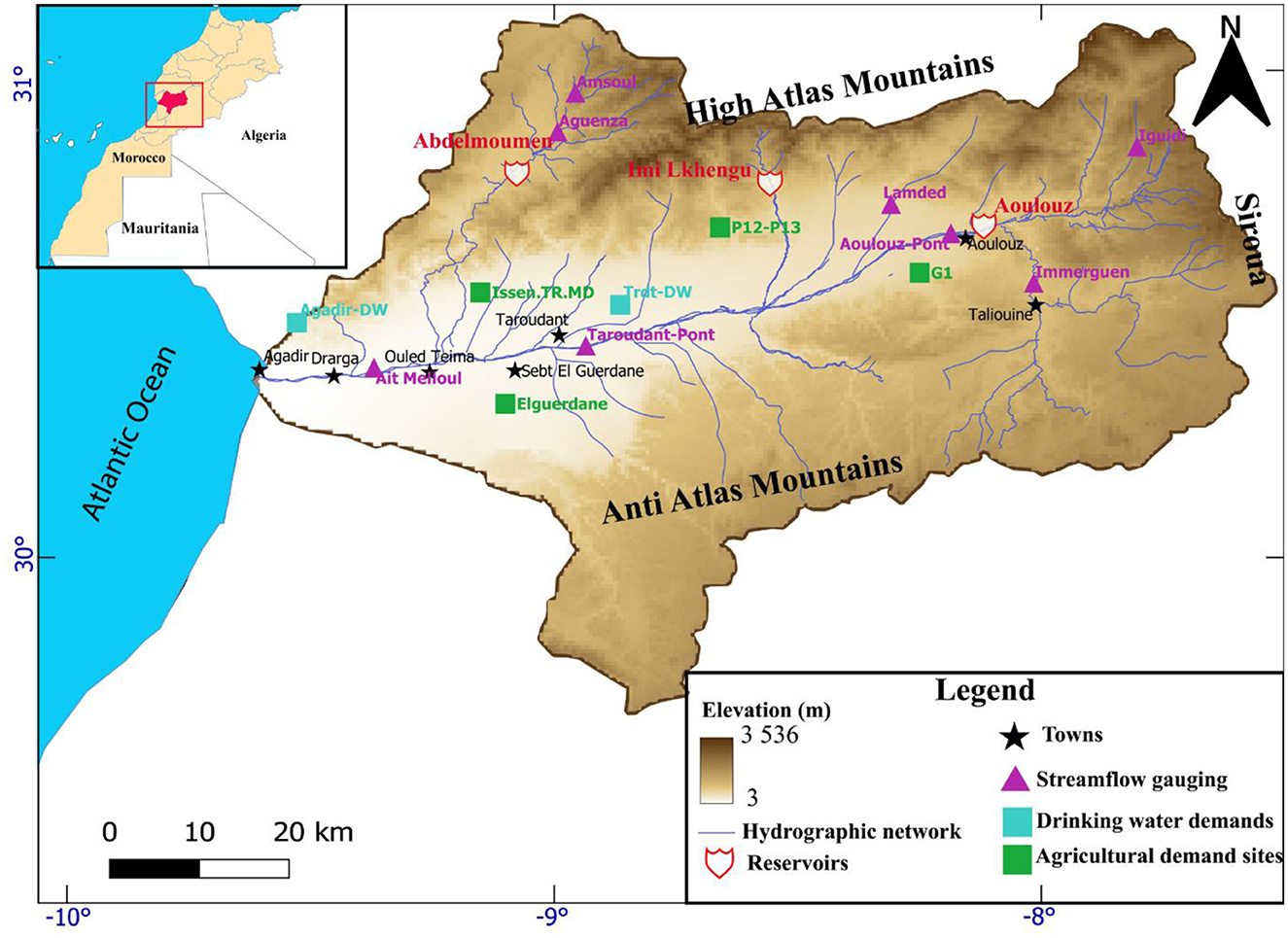
Figure 1. Location of the Souss basin, the topography, streamflow network and streamflow gauging stations.
In recent decades, monthly observations highlight substantial seasonal irregularities, notably a decreasing trend in precipitation and a simultaneous increase in average monthly temperatures (Figure 2). The mean annual temperature changes from 14°C to 20°C from north to south. In the summer, the maximum temperature can reache 49°C while in the winter the temperature sees lows of −3°C. Precipitation has an average of 600 mm in the High Atlas, 150 mm in the Anti Atlas and the plain gets an annual average of 200 mm (Ait Brahim et al., 2017; Seif-Ennasr et al., 2017; Abahous et al., 2018b).
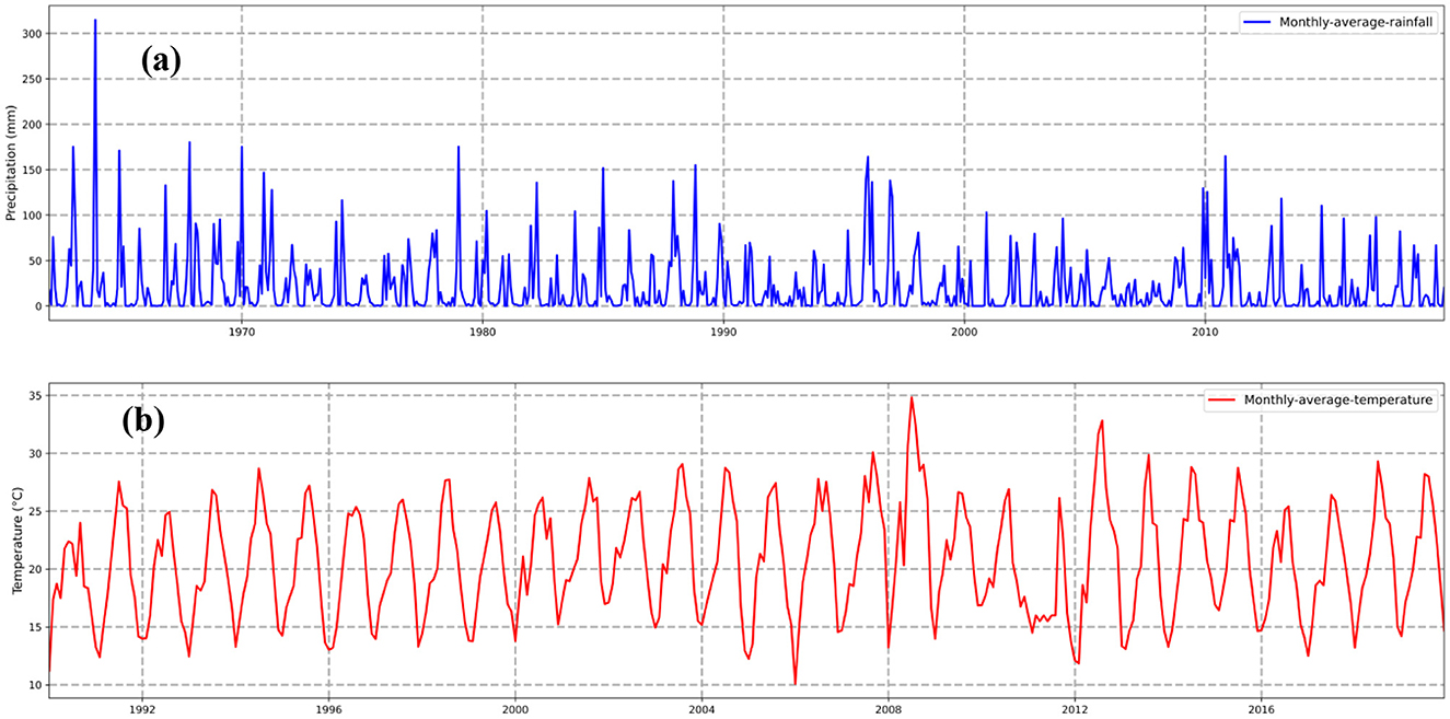
Figure 2. (a) Seasonal variation of monthly precipitation in the Souss basin displaying decreasing trend, (b) Seasonal variation of monthly temperature in the Souss basin displaying an increasing trend.
According to the RCP 4.5 (optimistic Representative Concentration Pathway 4.5 Wm−2 toward 2100) and RCP 8.5 scenarios (pessimistic Representative Concentration Pathway 8.5 Wm−2 toward 2100), the average temperature should rise by 1.5 and 2.5 degrees Celsius between 2045 and 2055, and by 3 and 6 degrees Celsius by the end of the century. On the other hand, climate change will affect precipitation. In both the RCP4.5 and RCP8.5 scenarios, precipitation will drop by 10% to 30% between 2030 and 2049, and by up to 60% between 2080 and 2099 (Seif-Ennasr et al., 2016).
The Hydraulic Basin Agency (ABHSM) has the legal authority to coordinate and manage the water and the administration of all the consumers and suppliers of water. The Souss-Massa Hydraulic Basin Agency collaborates with several stakeholders, including the Regional Agricultural Development Office of Souss-Massa (ORMVASM) and the National Drinking Water Office (ONEP), that supplies water to rural and urban consumers.
The agricultural development of the basin depends mainly on the Souss water table, and is supplemented by the releases of the three dams (Aoulouz, Imi-lkhengu and Abdelmoumen) of the basin. The volumes of the dams are mainly intended to satisfy the demand for drinking water in the basin. The areas supplied directly by the dams in the basin are grouped into four main areas (Figure 1).These perimeters are: (a) the G1 perimeter, (b) the Elguerdane perimeter, (c) the traditional Issen perimeter and the modern Issen perimeter (ISSEN. TR.MD) and (d) P12-P13. The main crops of these four perimeters are market gardening, cereals and citrus.
Based on the abundance of its natural resources, the Souss basin has considerable economic potential. The region's growth is mostly related to the agricultural sector, the fishing industry, tourism and the mining industry. In spite of its dry climate, the region is currently experiencing intensive agriculture production which constitutes the main economic system in the region. The agricultural area represents 100,000 ha. The majority of these lands are located in the Souss plain, which is known for its early crops and citrus fruit production
However, despite all these difficulties, the area is the first, in Morocco, in terms of exporting vegetables and citrus fruits. The Souss region is responsible for 6.6% of the country's gross domestic product (GDP), as reported by the High Commission for Planning and deduced from an investigation into the years 2013–2017. On the other hand, 15.3% of the regional gross domestic product is contributed by the region's agriculture production.
In this research, we provide a methodological framework that was developed in order to analyse the water management in the study area basin. The Methodology adopted for the study is illustrated in Figure 3. The figure provides the steps that were taken in order to successfully implement the model.
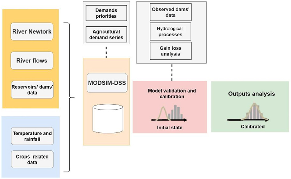
Figure 3. Methodological framework adopted in the study.
Meteorological time series data, crop surface data, data on water demand and data on water supply were all utilized in this study. The inputs for ModSim were gathered from a variety of different sources including the streamflow simulation of missing data using the GR2M model (Mouelhi, 2003; Mouelhi et al., 2006) and calculation of crop water requirements.
Climate data for (1990–2019) from nine stations in the Souss basin were obtained. Data on the flows of the tributaries of Oued Souss were obtained from the Agency of the hydraulic basin of Souss-Massa (ABHSM). The flows were selected for the stations of the tributaries of Oued Souss (Iguidi, Immerguen, Lemdad, Amsoul, Aguenza) and the stations located at Oued Souss (Aoulouz.Pont, Taroudant.Pont, Ait Melloul). ModSim was calibrated and evaluated using flow data.
In order to finish preparing the missing data, the rainfall-runoff model GR2M (Mouelhi, 2003; Mouelhi et al., 2006) was used. Precipitation and potential evapotranspiration are the primary factors that were considered by the model. The model was chosen for its simplicity and to overcome the over-parameterization of other complex models (Zamoum and Souag-Gamane, 2019). The GR2M model has been successfully applied in various geographical and climatic contexts. Planning and management of water resources are the two main applications of the GR2M model (Dezetter et al., 2008). The GR2M model has been the solution and the tool that is being loosely used to predict monthly runoff in ungauged watersheds (Zamoum and Souag-Gamane, 2019), as well as the reconstruction of monthly runoff information (O'Connor et al., 2021). In the case of lack of data, the simple structure of the model makes it the best solution to simulate monthly flows correctly (Bachir et al., 2015).
Irrigation site data were collected through consultations with governmental organizations Regional Agricultural Development Office (ORMVASM). The consultations included the identification and location of agricultural perimeters, water sources, crop surfaces, and irrigated areas. The data were used to estimate crop water requirements. In addition, additional perimeter data were extracted from reports and studies on the Souss basin.
Table 1 displays the different hydrological and demands inputs used for ModSim. The simulation is calibrated based on the period 1990–2009 flow measured on the Souss River at the Taroudant-Pont and Ait Melloul measuring sites. The period 2010–2019 was used for the validation of the model.
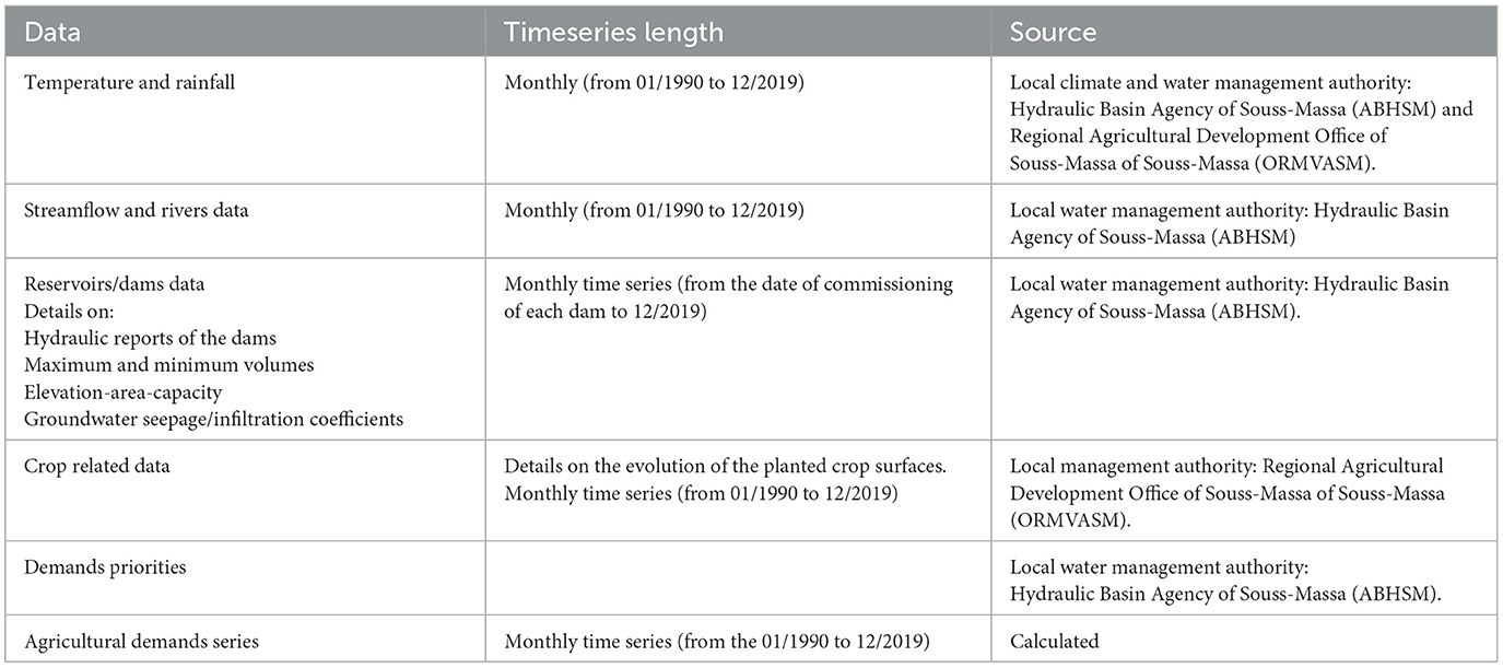
Table 1. ModSim input data.
The decision support system program ModSim was first developed in 1978 at Colorado State University (Shafer and Labadie, 1978). In ModSim, links and nodes reflect the physical and hydrological properties of a river basin system as well as artificial and conceptual components to simulate the complicated administrative and legal systems affecting water allocation. These links and nodes are required to ensure the mass balance of the network (Labadie, 2010).
ModSim solves a network flow optimization problem for each time period t = 1,…,T:
subject to
A represents the set of all links in the network, the group of node is represented by N. Oi is the group of links that start at node i. Ii is the group of links that end at node i ; bit represents the gain (positive) or loss (negative) that occurred at node I during the time period t; qk is the flow rate in link k; ck represent the costs or water right priorities per unit of flow; in link k. lkt and ukt are lower and upper bounds, respectively, on the flow in link k at time t. bit, lkt, and ukt are network flow vector q functions (Labadie, 2010).
Using ModSim, the Souss basin system was represented with nodes and links (Figure 4). The nodes represent the reservoirs (dams), demands and confluences of rivers. The links represent the sections of the rivers or diversions linking the dams with the consumer demands. The three reservoir nodes represent the three dams Aoulouz Dam (AOULOUZ DAM), Imi-lkhengu Dam (LKHENG DAM) and Abdelmoumen Dam (ABDMNN DAM). The irrigation demand nodes represent the agricultural perimeters: The G1 perimeter, the modern and traditional Issen perimeters (Issen.TR.MD), Elguerdane perimeter and the P12–P13 perimeter. The two applications DW.AGADIR and DW.Taroudant represent the two drinking water demands of the two cities Agadir and Taroudant respectively.
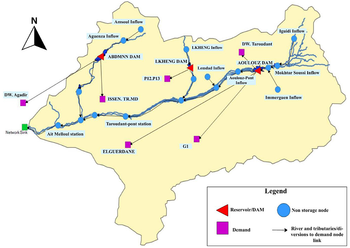
Figure 4. ModSim model network.
To get the monthly average values of evapotranspiration, the equation developed by Blaney and Criddle (1962) is used. The equation is the most frequent and extensively used particularly in dry and semi-arid regions as well as in areas with a lack of data (Espadafor et al., 2011; El-Nashar and Hussien, 2013; Valipour et al., 2017). In this study, the irrigation water demand was estimated by combining data collected from the regional development office (ORMVASM) on the perimeter crops, the types of crops and the calculated evapotranspiration. Crop coefficients were provided by FAO document 56 (Allen et al., 1998). Cultivated areas were multiplied by water requirements to determine agricultural water demand.
In this study we considered two development paths to make the analyses. In the first period (1990–2006), the dams provide a small part of the discharges for irrigation and the irrigation of relied mainly on pumping from the groundwater. The period (2007–2019) where the area started to adopt new policies to safeguard the agricultural areas namely the project to safeguard the citrus growing area of Elguerdane which consists of a transfer of an annual volume of water from the Aoulouz dam, and the rehabilitation of small and medium irrigation schemes in the Souss region. The information on the two periods was built based on information from the official document which is the Master Plan for Water Resources Management in the Souss Massa Drâa region, which provides the regional planning of water resources management in the region.
In order to construct a solid reference for modeling for the scientific community in the area, and since no previous Decision Support System tool was performed in the Souss basin, important efforts were made to push the model to replicate the historical processes of the study area. ModSim is not provided with automatic calibration or parameters estimation capabilities. Manual calibration can be very time-consuming, and this has been one of the biggest challenges of this first use of the model in the Souss basin. The calibration of the model was performed by adopting the knowledge of the physical parameters of the watershed, the hydrologic processes, and the experience with the model. The assessment of the calibration and validation was based on the manual inspection of the results over time. The trial-and-error procedure was adopted to adjust the parameters while comparing and evaluating the observed and simulated outputs using graphical plots. The approach was by making the best estimation of the network parameters and the actual data and then making sure that predicted flows match the trends and general tendency of the observed data.
The gain loss analysis of the network was first performed for the Souss basin. Then the first 19 years (1990–2009) of the data sets were used for the calibration and the last 9 years (2010–2019) were used for the model verification. Different assumptions were used for the simulation to develop the unexplained gain and loss terms firstly analyzed.
The first calibration (hydrologic calibration) was used in the model to calibrate its water mass balance and to define the model accuracy and deficiencies in the input data, then the second calibration was performed using the observed reservoir volumes as target storage to represent the different operations of the reservoirs. The calibration was performed to meet the flow levels observed in the gaging stations along the Souss river, using observed flows from the calibration time for the water deliveries, and the infiltration coefficient of the bed of the wadis, reservoir seepage loss coefficient and the evaporation of the dams.
In the absence of any prior initiatives to determine infiltration coefficients in the basin, a considerable effort is being made, but it is still not sufficient. Significant efforts were made to determine the importance of the infiltration processes in the area and determine the volume part that will participate in the recharge of the groundwater. The ModSim model was an ideal opportunity to adjust these parameters taking into consideration the geology of the bed of Oued Souss and of its tributaries.
The determination coefficient (R2), the Nash–Sutcliffe coefficient (NSE), and the per cent bias (PBIAS) were the three statistical indicators that we looked at in order to confirm that there was a maximal concordance between MODSIM estimated flows and observed flow records :
Where:
Oi: the value of the observed parameter during interval i
Si: the value of the simulated parameter during same interval i
Oavg: the observed average values of the parameters per time period
SPavg: the simulated average values of the parameters per time period
n: total time intervals.
Modsim-DSS has been used in several studies, and for many climatic conditions, including semi-arid climates (Cheong, 2008; Shourian et al., 2008; Fereidoon and Koch, 2018; Behboudian and Kerachian, 2021), but rarely in the African context. In fact, ModSim has been used in Ethiopia (Berhe et al., 2013) to analyze the water allocation to the upper, middle, and lower valleys of the Awash Basin at different levels of irrigation development. The approach developed in this study provides a first application of water allocation modeling of the Souss basin in Morocco. The development of the model calibration, and the design of the basin operating rules are a major achievement of this study. As this is the first time such a model has been applied in the region, Modsim-DSS has shown acceptable results in reproducing the hydrological processes that occur in a semi-arid environment.
After calibration, the observed monthly flows compared to the simulated flows, both ModSim simulated dams' inputs and hydrological stations installed in the Souss river reasonably match the observed data. Figure 5 illustrates the differences between the flows of simulated and observed volumes of the inputs of Abdelmoumen and Aoulouz dams throughout the calibration (1990–2009) and validation (2010–2019) periods. For the two periods, the coefficients R2, NSE values are > 0.6. These findings suggest that ModSim is effective at reproducing observed data.
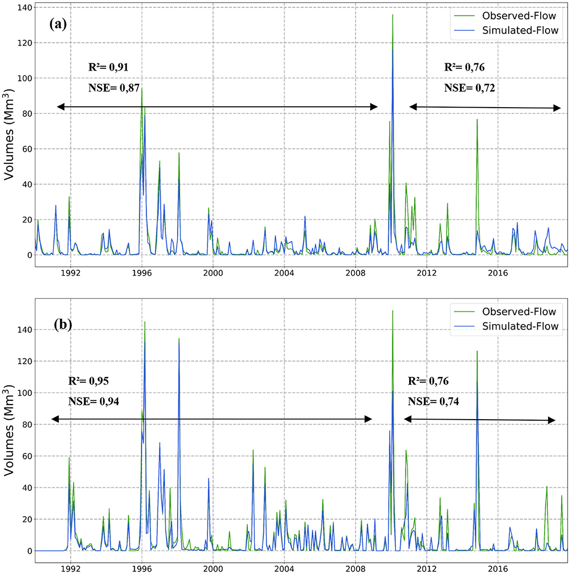
Figure 5. Simulated and observed monthly dams' inputs during the calibration and validation periods at (a) Abdelmoumen dam, (b) Aoulouz dam.
The hydrological calibration was carried out to meet the flow values reported by the gauging stations along the Oued Souss. This was achieved by utilizing data from the Taroudant Pont and Ait Melloul stations. The calibration process involved adjusting the infiltration coefficients of the Oued Souss beds, considering the loss coefficient at reservoir levels, and accounting for evaporation.
The simulated and observed flows for the calibration period (1990–2009) at the two stations Taroudant Pont and Ait Melloul are shown in Figure 6. The comparison indicates that model has well captured the general pattern observed at the two stations. The coefficients calculated are shown in Figure 6.
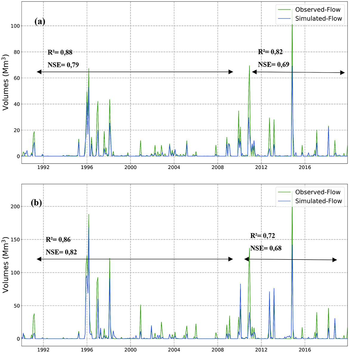
Figure 6. Simulated and observed monthly flows during the calibration and validation periods at stations (a) Taroudant-Pont, (b) Ait Melloul.
According to the results, ModSim tends to underestimate high flows (−30% to −38% of under estimation), as seen in the figures as well as the values of the PBIAS. This indicates that the inputs hydrologic data set may be missing certain tributary inflows that supply the Souss River. This may be explained by the fact that the right bank of the basin has a large number of tributaries which have a significant supply during flood periods but due to lack of data these supplies have not been taken into consideration. However, ModSim, on the other hand, is able to reliably follow low flows, which is likely of more significance given that the model is being used in the study to evaluate water allocation policies not the flood control operations. According to the findings of recent research, the general decrease in surface water flow that has been occurring in the Souss region since the early 1970s is directly related to the decrease in annual precipitation (Ait Brahim et al., 2017).
The inflows from the dams have been decreasing during the whole study period, which can be linked to the drought periods that the region has experienced during this period. Drought-related studies in the study area (Bouchaou et al., 2008; Tagma et al., 2009) found similar results, continuous periods of drought and climate variability have impacted the hydrology of the High Atlas Mountains, which feed the main dams and aquifer of the basin.
Results of agricultural demands for water are shown in Figure 7. With the increase of the temperature and the decrease of the precipitations, the agricultural water demand starts to increase in a significant way, which exceeds a value of 600 mm3 during the hot season. The monthly demand declines to 300 mm3 in the wet season (the monthly average demand increases by 55% in the hot season, compared to the demands of the rest of the year).
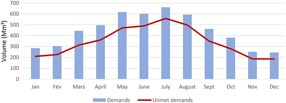
Figure 7. Monthly distribution of demand and unsatisfied demand during the simulation period (1990–2019).
A comparison of the water demand and the shortages recorded by all the perimeters every month is shown in Figure 7 which highlights the unsatisfied water demand. The increased demand in the summer season had led to an increase in the shortage in this period. The agricultural sector in the region is the most water-consuming where problems of water lack arise most in the hot period (May–Sep). This is explained by the fact that these months correspond to the dry seasons. In parallel, the groundwater pumping for irrigation will grow continuously during this period under the increase in demand. In contrast to the findings of Hadri et al. (2021), a study conducted in another Moroccan semi-arid area, the correlation between SPI (Standardized Precipitation Index) and SWI (Water-Level Index), shows is an increase in the use of groundwater to irrigate the primary crops. Hadri et al. (2021) also emphasized the significance of this time of year, which marks the beginning of the season for the development of many types of crops.
On the other hand, the findings of Lovelli et al. (2010) and Dettori et al. (2017) suggest that climate change has also induce increases in water demand (especially for irrigation), due to increased seasonal temperatures and evapotranspiration. Significant increases in temperature and decreases in precipitation lead to significant increases in water deficit and thus irrigation requirements. In fact, for some crops, the substantial increase in temperature and evapotranspiration demand leads to an anticipation of the thresholds for the beginning of the growing season and the harvest period (Lovelli et al., 2010; Dettori et al., 2017).
Figure 8 presents an overview of the annual total water requirements, supply, and unmet demand for the four perimeters (G1, Elguerdane, P12-P13, and Issen.TR.MD). Results from 1990 to 2019 show an average total water demand of 180 mm3, with the average total unmet demand that reached 163 mm3, constituting a substantial 92% of the total demand. Peak demand and unmet demand reached 206 mm3 and 201 mm3, respectively, emphasizing the need for improved water resource management. Affected by factors such as precipitation, available supply from dams, and actual evaporation, unmet demand from the agricultural sector is lower in years with more precipitation (such as 1990–1991). In contrast, unmet demand increases in other years. These results are related to the work of Bouchaou et al. (2008) and Tagma et al. (2009), which pointed out that the Souss region has had a number of problems related to a lack of water frequent, long-lasting droughts, and climate change especially in the last decades (Latifa et al., 2017; N'da et al., 2017; Oumarou Danni et al., 2017; Ez-zaouy et al., 2023).
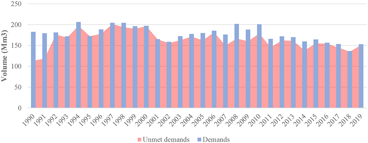
Figure 8. Annual distribution of demand and unsatisfied demand during the simulation period (1990–2019).
Irrigation accounts for a large part of water use in the study are. Moreover, the stored water in the dams is used for drinking water needs in the basin. Calculated delivered water supplies from each dam is shown in Figure 9, the figure shows the summary of water withdrawal from dams in the entire Souss basin for the period 1990–2019. The simulation period witnessed a considerable decrease in the supply levels from the different dams. The supplies decline in the last years (2012–2019) by 52% for Aoulouz dam and 89% for ABDMNN dam, while the supplies have decreased by 38% for lkhengu dam (Figure 9). The differences among different supply sources fluctuate during the simulation period, resulting from changes in the available water inputs each year.
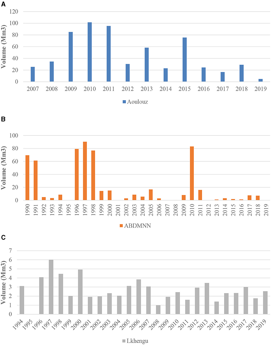
Figure 9. Delivered water supplies from each dam (1990–2019), (A) Aoulouz dam, (B) Abdelmoumen dam, (C) Lkhengu dam.
In the studied perimeters, the extension of market gardening and citrus fruits, which require a lot of water, is unsuited to the potential of the aquifer, and constitutes a threat to the sustainability of groundwater resources (Choukr-Allah et al., 2017). In addition, during periods of surface water scarcity, farmers have to rely heavily on groundwater to compensate for the lack of river flow and the absence of supply from reservoirs (Heidecke et al., 2010; Seif-Ennasr et al., 2016). As a result, the Souss aquifer is subject to continuous intensive use that does not allow it to regenerate (Seif-Ennasr et al., 2021).
The annual water supply does not match the demand for all perimeters. Figure 9 indicates that the unmet demand has always been important during the study period. During the period 2007–2019, after the rehabilitation of the perimeters and the supply of the different perimeters by dam releases, the unmet water demand amounts have slightly decreased. However, it has increased from 82% to 94% for the Issen perimeter and this is mainly due to the decrease in the Abdelmoumen dam inflows (Figure 5) which is the main source of irrigation releases for the traditional and modern perimeters of ISSEN. After the realization of the two projects that aim to supply the two perimeters Elguerdane and G1 with water from the Aoulouz dam, the unmet water demand has decreased to 87% and 91% respectively (Figure 10).
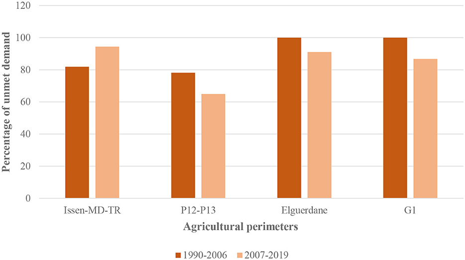
Figure 10. The percentage of unmet demand before and after the rehabilitation of the perimeters and supply of the different perimeters by dams.
Even though the releases from the dams have reduced the demands of the two perimeters, the unmet demand remains high at these sites. The results suggest that the unmet demand is significant for all demand sites. Indeed, the demands will be met by the uncontrolled withdrawal of water from groundwater resources. These findings are in line with Hirich et al. (2017) and Seif-Ennasr et al. (2017) who discuss the development of the Souss region resulting in increasing demand for irrigation and a major loss of groundwater reserves.
Identical conclusions have been made by Bouchaou et al. (2017). The spatio-temporal decrease in groundwater levels observed in the area is related to the successive years of drought as well as to the considerable intensification of pumping (Bouchaou et al., 2017). On the other hand, and by analyzing the evolution of the levels of the groundwater resources of the Souss basin (Ait Brahim et al., 2017; Hssaisoune et al., 2017), demonstrated that the groundwater resources have shown a decrease in the last years. This decrease concerns all irrigation areas. They confirmed that groundwater resources are seriously affected by the succession of drought years and overexploitation mainly caused by agriculture. Over the past four decades, annual water level declines have averaged 0.5–2.5 meters (Hssaisoune et al., 2020).
Climate analyses in Morocco, established in the framework of the 3rd National Communication of Morocco to the United Nations Framework Convention on Climate Change, suggest that the average annual temperatures will increase for the period (2016-2035) from 1.0 to more than 1.8°C and precipitation will decline by between 3 and 30% (UNFCC, 2016). According to the conclusions of these climate change studies, many authors (Bouchaou et al., 2017; Elame et al., 2020; Seif-Ennasr et al., 2021) have claimed that because of the drought, there has been a huge rise in the overexploitation and the use of groundwater for irrigation. Our findings provide strong support to those conclusions as well.
The future development plans of agriculture and their potential impact on water supplies in the Souss basin should also be examined. The unsatisfied demands highlighted in this study have been of course satisfied through pumping which harms the groundwater resources of the Souss basin. In addition, the region has been equipped with development plans, namely the Generation Green strategy and the Plan 2020–2027, to enable this region to continue its territorial development and contribute to the national socio-economic growth. As a consequence, the influence of climate change on the hydrology of the area and the water demand will likely become much more pronounced which will certainly affect the water balance. Therefore, a simulation of the interactions between the hydrological cycle and water users in the region to explore the medium- and long-term future scenarios in the region under climate change would be beneficial (Attar et al., 2022).
Water resources management in semi-arid basins, such as Souss in Morocco, requires holistic approaches (Parson and Fisher-Vanden, 1997; Davies and Simonovic, 2011; Bouchaou et al., 2017). To ensure economic and social stability and sustainable use of water resources, a conceptual model integrating the different challenges and opportunities of the basin will help to achieve the goal of sustainable use (Momm et al., 2022). The model will include a systematic approach where at each step the different pressures and drivers will be taken into consideration, and they will help to understand the interactions between the different components of the watershed and then produce improved decisions and measures.
The approach proposed herein (Figure 11) consists of two main steps: the starting point is the characterization of the current situation of the basin, and this is done through data collection or through the literature. After the data collection, a process must be conducted to distinguish the key causes that affect the water resources of the area. Then, the structure of the model will be extracted by analyzing the different relationships between the parameters of the framework (Qi and Altinakar, 2011; Apostolaki et al., 2019).
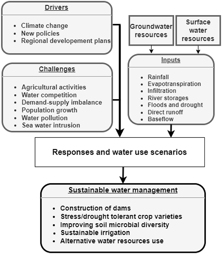
Figure 11. Schematization of the proposed conceptual framework with a sustainable water use goal.
After determining the current situation of the basin, the various opportunities, challenges, and strengths that involve the basin's resources must be defined. The analysis will start with a detailed characterization of the different hydrological components and processes of the basin. This step also involves mapping the pressures and drivers on the water resources. The various changes and pressures on the state of the basin indicate the problems and constraints on the resources and human activities, and these problems and constraints may be exacerbated by current and future drivers (Maxim et al., 2009; Potschin, 2009; Kagalou et al., 2012; Gari et al., 2018). This simulation will provide a picture of the basin's situation and will help develop informed responses as part of development plans for water-stressed regions.
Such an approach will help complex and semi-arid systems in mastering the relationships between production and resource sustainability (Terêncio et al., 2017, 2018; Brouziyne et al., 2018; Hssaisoune et al., 2020). In the next step, the design of this model will lead to the adoption and implementation of management policies to adapt to the different risks (Stocker et al., 2013; Schröder et al., 2019; Seif-Ennasr et al., 2021).
Farm management decisions are not always well understood, and agricultural production systems are rapidly evolving in response to changing customer expectations, food security concerns, and environmental impacts. In this context, the analyses adopted in this type of models will allow the generation of source-demand connections and the understanding of the effects of various conditions in time and space. Therefore, they allow specifying the different relevant measures that can be taken to decrease the negative impacts on the economy, society and the environment.
In our study we used the water resource systems model ModSim-DSS to analyze the various water allocations of a semi-arid watershed as well as to illustrate the region's water balance at various irrigation perimeters. The analysis integrated the development of the agri-demand to examine the different consequences on a complex nationally important river basin system that combine major consumptive demands (agriculture and drinking water) and complex multifunctional infrastructures as well as the different development plans.
For meaningful assessment of results and crucial usage in decision making, models must be correctly calibrated and validated using observable data. Data is considered a classic issue in modeling dry areas. A considerable limitation of this proposed framework in this study is the data quality and quantity. Due to the fact that semi-arid agricultural watersheds are susceptible to intense hydrologic and anthropogenic impacts, having access to relevant data is essential (Samimi et al., 2020). However, the flow measurement stations in the sections of Oued Souss and its tributaries have some gaps, the different floods that the area has experienced have damaged the different measurement tools which resulted in several missing records that could not be measure at the station, and the tributaries of the Souss river were not gauged for longer periods. The model performance was improved with the estimation of the missing either by the linear regression or the use of an external model to fill the gaps of the stations.
The study has known some limitations which need to be improved to deal with the different interactions of the basin in future works. Firstly, ModSim was carefully calibrated to better understand and validate the different parameters characterizing the basin. The calibration integrated the customization features of the model. This later gives the opportunity to use automatic calibration to estimate the basin parameters. Basin parameters in the model need to be estimated with highest precision to ensure that the model's outputs can be based upon and that the model's simulations closely match observations (Maclean, 2009; Moradkhani and Sorooshian, 2009). Hence, the use of optimization algorithms to develop automatic calibration has shown interesting results (Sabzzadeh et al., 2016). With the automatic calibration, the determination of the parameter's procedure is formulated as an optimization problem through an objective function. These algorithms help to improve the objective function by looking at and testing different parameter values to help the model replicate the observed data.
In the study area, the infiltration process has never been previously studied. However, the soil-water infiltration plays an important function in hydrology as well as contributing to the groundwater recharge (Kale and Sahoo, 2011; Mahapatra et al., 2020). Different data-based and machine-learning strategies have recently been developed to improve the accuracy of estimates of water infiltration (Lange and Sippel, 2020; Panahi et al., 2021; Sun et al., 2021). These algorithms proved their effectiveness in characterizing the variable affecting the infiltration process. It is also recommended to collect various data and use Machine learning algorithm power in the prediction of the infiltration process and infiltration rate (Panahi et al., 2021).
This work shows how ModSim, a generic DSS can be used to model water allocations. The Souss basin, which is located in Morocco, is selected for this ModSim application because of its relevance to water planning and management issues. All basin facilities, hydrological processes, and water use are included in monthly time-step simulations. The simulation of inflow required a significant amount of calibration effort. The inflows to the Aoulouz and Abdelmoumen reservoirs were successfully modeled using, resulting in a strong correlation with the inflows recorded at the dams. The model simulated flows were well matched to the observed hydrograph volumes for the gauging stations installed at Oued Souss.
The results indicate that the average total water demand for the period (1990–2019) is 180 mm3, while the average total unmet demand is 201 mm3 of the total demand. The monthly average demand increases by 55% in the hot season, compared to the demands of the rest of the year. With regards to the unsatisfied demand at the level of each perimeter, the largest unsatisfied water demand during the second period 2007–2019 occurs at the level of Issen perimeter with 94% of the demand remaining unsatisfied by the dam releases. The results also indicate that the other demand sites in the watershed have unmet demands that remain high for both periods. The unmet water demands will be probably satisfied by the uncontrolled withdrawal of water from groundwater resources. The study's findings and the use of ModSim highlight the importance of enhancing water governance in the Souss basin. More efforts to build representations of groundwater and surface water interactions are needed to improve water governance even further. More in-depth assessments and the use of advanced modeling methods may be required to better understand the consequences of various water uses, particularly in arid and semi-arid areas where water is limited.
The original contributions presented in the study are included in the article/supplementary material, further inquiries can be directed to the corresponding author.
OA: Conceptualization, Data curation, Formal analysis, Investigation, Methodology, Software, Writing—original draft, Validation. YB: Conceptualization, Data curation, Methodology, Supervision, Validation, Writing—review & editing. LB: Conceptualization, Methodology, Supervision, Writing—review & editing, Validation. AE: Writing—review & editing. YA: Writing—review & editing, Conceptualization, Supervision, Validation. AC: Writing—review & editing.
The author(s) declare financial support was received for the research, authorship, and/or publication of this article. This research was supported by the grant of Mohammed VI Polytechnic University. This research was supported by the PRIMA AGREEMed project and the APRD GEANTeck Project.
Our thanks also go to the staff of Hydraulic Agency and the Regional Office of Agricultural Development of Souss-Massa. The authors thank the editor and the reviewers for their constructive comments.
The authors declare that the research was conducted in the absence of any commercial or financial relationships that could be construed as a potential conflict of interest.
All claims expressed in this article are solely those of the authors and do not necessarily represent those of their affiliated organizations, or those of the publisher, the editors and the reviewers. Any product that may be evaluated in this article, or claim that may be made by its manufacturer, is not guaranteed or endorsed by the publisher.
Abahous, H., Ronchail, J., Sifeddine, A., Kenny, L., and Bouchaou, L. (2018a). “Impacts of the water resources variability on cereal yields in the region of Souss-Massa Southern Morocco,” in Groundwater and Global Change in the Western Mediterranean Area. Environmental Earth Sciences, eds M. Calvache, C. Duque, D. Pulido-Velazquez (Cham: Springer). doi: 10.1007/978-3-319-69356-9_1
Abahous, H., Ronchail, J., Sifeddine, A., Kenny, L., and Bouchaou, L. (2018b). Trend and change point analyses of annual precipitation in the Souss-Massa Region in Morocco during 1932–2010. Theor. Appl. Climatol. 134, 1153–1163. doi: 10.1007/s00704-017-2325-0
Achli, S., Epule, T. E., Dhiba, D., Chehbouni, A., and Er-Raki, S. (2022). Vulnerability of barley, maize, and wheat yields to variations in growing season precipitation in Morocco. Appl. Sci. (Switzerland) 12, 1–28. doi: 10.3390/app12073407
Ait Brahim, Y., Bouchaou, L., Sifeddine, A., Beraaouz, E. H., Wanaim, A., and Cheng, H. (2019). Hydro-climate characteristics of the karst system of Wintimdouine cave (Western High Atlas, Morocco): monitoring and implications for paleoclimate research. Environ. Earth Sci. 78, 5. doi: 10.1007/s12665-019-8496-5
Ait Brahim, Y., Seif-Ennasr, M., Malki, M., Choukrallah, R., el Morjani, Z. E., Sifeddine, A., et al. (2017). Assessment of climate and land use changes: Impacts on groundwater resources in the Souss-Massa river basin. Handb. Environm. Chem. 53, 121–142. doi: 10.1007/698_2016_71
Allain, S., Plumecocq, G., and Leenhardt, D. (2020). Linking deliberative evaluation with integrated assessment and modelling: a methodological framework and its application to agricultural water management. Futures 120, 102566. doi: 10.1016/j.futures.2020.102566
Allen, R. G., Pereira, L. S., Raes, D., Smith, M., and Ab, W. (1998). “Crop evapotranspiration - Guidelines for computing crop water requirements,” in FAO Irrigation and Drainage Paper 56 (Rome: FAO).
Apostolaki, S., Koundouri, P., and Pittis, N. (2019). Using a systemic approach to address the requirement for Integrated Water Resource Management within the Water Framework Directive. Sci. Total Environ. 679, 70–79. doi: 10.1016/j.scitotenv.2019.05.077
Attar, O., Brouziyne, Y., Bouchaou, L., and Chehbouni, A. (2022). A critical review of studies on water resources in the Souss-Massa Basin, Morocco: envisioning a water research agenda for local sustainable development. Water (Basel) 14, 1355. doi: 10.3390/w14091355
Bachir, S., Nouar, B., Hicham, C., Azzedine, H., and Larbi, D. (2015). Application of GR2M for rainfall-runoff modeling in Kébir Rhumel Watershed, north east of Algeria. World Appl. Sci. J. 33, 1623–1630.
Balaghi, R. (2017). État de l'art, vulnérabilité, impact sur les terres et les principales cultures-mapm. Rabat: Agence pour le Développment agricole.
Behboudian, M., and Kerachian, R. (2021). Evaluating the resilience of water resources management scenarios using the evidential reasoning approach: the Zarrinehrud river basin experience. J. Environ. Manage. 284, 112025. doi: 10.1016/j.jenvman.2021.112025
Benabdelouahab, T., Balaghi, R., Hadria, R., Lionboui, H., Minet, J., and Tychon, B. (2015). Monitoring surface water content using visible and short-wave infrared SPOT-5 data of wheat plots in irrigated semi-arid regions. Int. J. Remote Sens. 36, 4018–4036. doi: 10.1080/01431161.2015.1072650
Berhe, F. T., Melesse, A. M., Hailu, D., and Sileshi, Y. (2013). MODSIM-based water allocation modeling of Awash River Basin, Ethiopia. Catena (Amst) 109, 118–128. doi: 10.1016/j.catena.2013.04.007
Bijaber, N., El Hadani, D., Saidi, M., Svoboda, M. D., Wardlow, B. D., Hain, C. R., et al. (2018). Developing a remotely sensed drought monitoring indicator for Morocco. Geosciences (Switzerland) 8, 1–18. doi: 10.3390/geosciences8020055
Blaney, H. F., and Criddle, W. D. (1962). “Determining consumptive use and irrigation water requirements,” in United States Department of Agriculture Technical, 1–59.
Borden, C., Gaur, A., and Singh, C. R. (2016). Water Resource Software. Water Res. Softw. 2016, 1–76. doi: 10.1596/24762
Bouchaou, L., Choukr-Allah, R., Hirich, A., Ennasr, M., Malki, M., Abahous, H., et al. (2017). Climate change and water valuation in Souss-Massa region: Management and adaptive measures. Eur. Water 60, 203–209.
Bouchaou, L., Tagma, T., Boutaleb, S., Hssaisoune, M., and El Morjani, Z. E. A. (2011). Climate change and its impacts on groundwater resources in Morocco: the case of the Souss-Massa basin. Clim. Change Eff. Groundw. Resour. A Glob. Synth. Find. Recomm. 129, 147–162. doi: 10.1201/b11611-13
Bouchaou, L., houssaine.Michelot, J. L., Vengosh, A., vner.Hsissou, Y.oussef., Qurtobi, M., ohamed.Gaye, C. B., et al. (2008). Application of multiple isotopic and geochemical tracers for investigation of recharge, salinization, and residence time of water in the Souss-Massa aquifer, southwest of Morocco. J. Hydrol. (Amst) 352, 267–287. doi: 10.1016/j.jhydrol.2008.01.022
Bras, L., and Cordova, J. R. (1981). Intra-seasonal water allocation in deficit irrigation. Water Resour. Res. 17, 866–874. doi: 10.1029/WR017i004p00866
Brouziyne, Y., Abouabdillah, A., Chehbouni, A., Hanich, L., Bergaoui, K., McDonnell, R., et al. (2020). Assessing hydrological vulnerability to future droughts in a mediterranean watershed: combined indices-based and distributed modeling approaches. Water (Switzerland) 12, 2333. doi: 10.3390/w12092333
Brouziyne, Y., Abouabdillah, A., Hirich, A., Bouabid, R., Zaaboul, R., and Benaabidate, L. (2018). Modeling sustainable adaptation strategies toward a climate-smart agriculture in a Mediterranean watershed under projected climate change scenarios. Agric. Syst. 162, 154–163. doi: 10.1016/j.agsy.2018.01.024
Brouziyne, Y., De Girolamo, A. M., Aboubdillah, A., Benaabidate, L., Bouchaou, L., and Chehbouni, A. (2021). Modeling alterations in flow regimes under changing climate in a Mediterranean watershed: an analysis of ecologically-relevant hydrological indicators. Ecol. Inform. 61, 101219. doi: 10.1016/j.ecoinf.2021.101219
Cheong, T. (2008). Application of MODSIM to Hydropower Operations in the Geum River Basin, Korea. Daegu: Korea Water Resources Corporation, 1–22.
Choukr-Allah, R., Nghira, A., Hirich, A., and Bouchaou, L. (2017). Water resources master plan for sustainable development of the Souss-Massa River Basin. Handb. Environm. Chem. 53, 1–26. doi: 10.1007/698_2016_67
Cook, C., and Bakker, K. (2012). Water security: debating an emerging paradigm. Global Environm. Chang. 22, 94–102. doi: 10.1016/j.gloenvcha.2011.10.011
Danni, S. O., Bouchaou, L., Elmouden, A., Ait Brahim, Y., and N'da, B. (2019). Assessment of water quality and nitrate source in the Massa catchment (Morocco) using δ 15N and δ 18O tracers. Appl. Radiat. Isotopes 154, 108859. doi: 10.1016/j.apradiso.2019.108859
Davies, E. G. R., and Simonovic, S. P. (2011). Global water resources modeling with an integrated model of the social-economic-environmental system. Adv. Water. Resour. 34, 684–700. doi: 10.1016/j.advwatres.2011.02.010
Dettori, M., Cesaraccio, C., and Duce, P. (2017). Simulation of climate change impacts on production and phenology of durum wheat in Mediterranean environments using CERES-Wheat model. Field Crops Res. 206, 43–53. doi: 10.1016/j.fcr.2017.02.013
Dezetter, A., Girard, S., Paturel, J. E., Mah,é, G., Ardoin-Bardin, S., and Servat, E. (2008). Simulation of runoff in West Africa: is there a single data-model combination that produces the best simulation results? J. Hydrol. 354, 203–212. doi: 10.1016/j.jhydrol.2008.03.014
El Bilali, A., Taleb, A., and Brouziyne, Y. (2021). Comparing four machine learning model performances in forecasting the alluvial aquifer level in a semi-arid region. J. African Earth Sci. 181, 104244. doi: 10.1016/j.jafrearsci.2021.104244
Elame, F., Doukkali, R., and Lionboui, H. (2020). Dynamic modeling of climate change impact on agricultural lands and water resources. Handb. Clim. Change Manage. 1–21. doi: 10.1007/978-3-030-22759-3_41-1
El-Nashar, W. Y., and Hussien, E. A. (2013). Estimating the potential evapo-transpiration and crop coefficient from climatic data in Middle Delta of Egypt. Alexandria Eng. J. 52, 35–42. doi: 10.1016/j.aej.2012.12.001
Espadafor, M., Lorite, I. J., Gavilán, P., and Berengena, J. (2011). An analysis of the tendency of reference evapotranspiration estimates and other climate variables during the last 45 years in Southern Spain. Agric. Water Manag. 98, 1045–1061. doi: 10.1016/j.agwat.2011.01.015
Ez-zaouy, Y., Bouchaou, L., Saad, A., Hssaisoune, M., Brouziyne, Y., Dhiba, D., et al. (2021). Morocco's coastal aquifers: recent observations, evolution and perspectives towards sustainability. Environ. Pollut. 293, 118498. doi: 10.1016/j.envpol.2021.118498
Ez-zaouy, Y., Bouchaou, L., Schreiber, H., Montcoudiol, N., Kalberkamp, U., Danni, S. O., et al. (2023). Combined geophysical methods to investigate seawater intrusion in the Souss-Massa coastal area, Morocco. Groundw. Sustain. Dev. 21, 100915. doi: 10.1016/j.gsd.2023.100915
Ezzine, H., Bouziane, A., and Ouazar, D. (2014). Seasonal comparisons of meteorological and agricultural drought indices in Morocco using open short time-series data. Int. J. Appl. Earth Observat. Geoinform. 26, 36–48. doi: 10.1016/j.jag.2013.05.005
Fereidoon, M., and Koch, M. (2018). SWAT-MODSIM-PSO optimization of multi-crop planning in the Karkheh River Basin, Iran, under the impacts of climate change. Sci. Total Environm. 630, 502–516. doi: 10.1016/j.scitotenv.2018.02.234
Gari, S. R., Ortiz Guerrero, C. E. A., Uribe, B., Icely, J. D., and Newton, A. (2018). A DPSIR-analysis of water uses and related water quality issues in the Colombian Alto and Medio Dagua Community Council. Water Sci. 32, 318–337. doi: 10.1016/j.wsj.2018.06.001
Gorantiwar, S. D., and Smout, I. K. (2005). Multilevel approach for optimizing land and water resources and irrigation deliveries for tertiary units in large irrigation Schemes II: application. J. Irrigat. Drain. Eng. 131, 264–272. doi: 10.1061/(ASCE)0733-9437(2005)131:3(264)
Guemouria, A., Chehbouni, A., Belaqziz, S., Epule Epule, T., Ait Brahim, Y., El Khalki, E. M., et al. (2023). System dynamics approach for water resources management: a case study from the souss-massa basin. Water (Switzerland) 15, 1506. doi: 10.3390/w15081506
Hadri, A., Saidi, M. E. M., and Boudhar, A. (2021). Multiscale drought monitoring and comparison using remote sensing in a Mediterranean arid region: a case study from west-central Morocco. Arab. J. Geosci. 14. doi: 10.1007/s12517-021-06493-w
Hadri, A., Saidi, M. E. M., El Khalki, E. M., Aachrine, B., Saouabe, T., and Elmaki, A. A. (2022). Integrated water management under climate change through the application of the WEAP model in a Mediterranean arid region. J. Water Clim. Change 00, 1–28. doi: 10.2166/wcc.2022.039
He, S., and Jiao, W. (2022). Adapting traditional industries to national park management: A conceptual framework and insights from two Chinese cases. J. Clean. Prod. 367, 133007. doi: 10.1016/j.jclepro.2022.133007
Heidecke, C., Kuhn, A., Liebelt, C., Speth, P., Christoph, M., and Diekkrüger, B. (2010). “Hydro-economic processes and institutions in Southern Morocco,” in Impacts of Global Change on the Hydrological Cycle in West and Northwest Africa, eds. P. Speth, M. Christoph, B. Diekkrüger (Heidelberg: Springer), 88–100.
Hirich, A., Choukr-Allah, R., and Nrhira, A. (2017). Groundwater-dependent ecosystems in the Souss-Massa river region: an economic valuation of ecosystem services. Handb. Environm. Chem. 53, 163–196. doi: 10.1007/698_2016_73
Hssaisoune, M., Bouchaou, L., Sifeddine, A., Bouimetarhan, I., and Chehbouni, A. (2020). Moroccan groundwater resources and evolution with global climate changes. Geosciences (Switzerland) 10, 81. doi: 10.3390/geosciences10020081
Hssaisoune, M., Boutaleb, S., Benssaou, M., Bouaakkaz, B., and Bouchaou, L. (2017). Physical geography, geology, and water resource availability of the Souss-Massa River Basin. Handb. Environm. Chem. 53, 27–56. doi: 10.1007/698_2016_68
Kagalou, I., Leonardos, I., Anastasiadou, C., and Neofytou, C. (2012). The DPSIR approach for an integrated river management framework. A preliminary application on a mediterranean site (Kalamas River -NW Greece). Water Res. Manag. 26, 1677–1692. doi: 10.1007/s11269-012-9980-9
Kale, R. V., and Sahoo, B. (2011). Green-Ampt infiltration models for varied field conditions: a revisit. Water Res. Manage. 25, 3505–3536. doi: 10.1007/s11269-011-9868-0
Labadie, J. (2010). MODSIM: Decision Support System for River Basin. Fort Collins: Department of Civil Engineering, Colorado State University 6.
Larson, R. K., and Spinazola, J. (2000). “Conjunctive management analyses for endangered species flow augmentation alternatives in the Snake River,” in Proceedings of Watershed Management and Operations Management 2000. (Reston, VA: Environmental and Water Re- sources Institute of the American Society of Civil Engineers), 1–7.
Latifa, A. Y., Lhoussaine, B., Etienne, J., Moussa, M., Yassine, A. B., Ahmed, E. M., et al. (2017). Impact of rock-water interactions and recharge on water resources quality of the Agadir-Essaouira basin, southwestern Morocco. Arab. J. Geosci. 10, 2. doi: 10.1007/s12517-017-2968-2
Le Page, M., Berjamy, B., Fakir, Y., Bourgin, F., Jarlan, L., Abourida, A., et al. (2012). An integrated DSS for groundwater management based on remote sensing. The case of a semi-arid aquifer in Morocco. Water Res. Manag. 26, 3209–3230. doi: 10.1007/s11269-012-0068-3
Loucks, D., van Beek, E., Stedinger, J., Dijkman, J., and Villars, M. (2005). Water Resources Systems Planning and Management: An Introduction to Methods, Vol. 2. Cham: Springer.
Lovelli, S., Perniola, M., di Tommaso, T., Ventrella, D., Moriondo, M., and Amato, M. (2010). Effects of rising atmospheric CO2 on crop evapotranspiration in a Mediterranean area. Agric Water Manag 97, 1287–1292. doi: 10.1016/j.agwat.2010.03.005
Maclean, A. J. (2009). Calibration and Analysis of the MESH Hydrological Model applied to Cold Regions. Ontario: University of Waterloo.
Mahapatra, S., Jha, M. K., Biswal, S., and Senapati, D. (2020). Assessing variability of infiltration characteristics and reliability of infiltration models in a tropical Sub-humid Region of India. Sci. Rep. 10, 8. doi: 10.1038/s41598-020-58333-8
Malki, M., Bouchaou, L., Hirich, A., Ait Brahim, Y., and Choukr-Allah, R. (2017). Impact of agricultural practices on groundwater quality in intensive irrigated area of Chtouka-Massa, Morocco. Sci. Total Environm. 574, 760–770. doi: 10.1016/j.scitotenv.2016.09.145
Malki, M., Choukr Allah, R., Bouchaou, L., Ait Brahim, Y., Hirich, A., and Reichert, B. (2016). Evolution of groundwater quality in intensive agricultural zone: case of Chtouka-Massa Aquifer, Morocco. Arab. J. Geosci. 9, 6. doi: 10.1007/s12517-016-2592-6
Malmir, M., Javadi, S., Moridi, A., Randhir, T., and Saatsaz, M. (2022). Integrated groundwater management using a comprehensive conceptual framework. J. Hydrol. 605, 127363. doi: 10.1016/j.jhydrol.2021.127363
Mansir, I., Bouchaou, L., Chebli, B., Ait Brahim, Y., and Choukr-Allah, R. (2021). A specific indicator approach for the assessment of water resource vulnerability in arid areas: the case of the Souss-Massa Region (Morocco). Hydrol. Sci. J. 66, 1151–1168. doi: 10.1080/02626667.2021.1924379
Maxim, L., Spangenberg, J. H., and O'Connor, M. (2009). An analysis of risks for biodiversity under the DPSIR framework. Ecol. Econ. 69, 12–23. doi: 10.1016/j.ecolecon.2009.03.017
Momm, H. G., Bingner, R. L., Moore, K., and Herring, G. (2022). Integrated surface and groundwater modeling to enhance water resource sustainability in agricultural watersheds. Agric Water Manag. 269, 107692. doi: 10.1016/j.agwat.2022.107692
Moradkhani, H., and Sorooshian, S. (2009). “General review of rainfall-runoff modeling: model calibration, data assimilation, and uncertainty analysis,” in Hydrological Modelling and the Water Cycle. Water Science and Technology Library, eds. S. Sorooshian, K. Hsu, E. Coppola, B. Tomassetti, M. Verdecchia, and G. Visconti, G. Berlin: Springer.
Mouelhi, S. (2003). “Vers une chaîne cohérente de modèles pluie-débit aux pas de temps pluriannue, annuel, mensuel et journalier,” in Ecole Nationale Du Genie Rural Des Eaux Et Des Forets.
Mouelhi, S., Michel, C., Perrin, C., and Andréassian, V. (2006). Stepwise development of a two-parameter monthly water balance model. J. Hydrol (Amst) 318, 200–214. doi: 10.1016/j.jhydrol.2005.06.014
Mourad, K. A., and Alshihabi, O. (2016). Assessment of future Syrian water resources supply and demand by the WEAP model. Hydrol. Sci. J. 61, 393–401. doi: 10.1080/02626667.2014.999779
Mousavi, S. J., and Shourian, M. (2010). Adaptive sequentially space-filling metamodeling applied in optimal water quantity allocation at basin scale. Water Resour. Res. 46, 1–13. doi: 10.1029/2008WR007076
N'da, B., Bouchaou, L., Reichert, B., Hanich, L., Danni, S., Ait Brahim, Y., et al. (2017). Chemical tracers and stable isotopes mixing models for groundwater quality and recharge study in the Moroccan High Atlas Mountains. Environ. Earth Sci. 235–244. doi: 10.1007/978-3-319-69356-9_27
O'Connor, P., Murphy, C., Matthews, T., and Wilby, R. L. (2021). Reconstructed monthly river flows for Irish catchments 1766–2016. Geosci. Data J. 8, 34–54. doi: 10.1002/gdj3.107
Ouarani, M., Brahim, Y. A., Mulla, D., Rafik, A., Azennoud, K., Bouchaou, L., et al. (2023). A comprehensive overview of groundwater salinization and recharge processes in a semi-arid coastal aquifer (Essaouira, Morocco). J. Hydrol. Reg. Stud. 49, 101501. doi: 10.1016/j.ejrh.2023.101501
Oumarou Danni, S., Bouchaou, L., Elmouden, A., N'da, B., Ait Brahim, Y., and Malki, M. (2017). Isotopic and chemical tracers for the sustainable management of water resources in semi-arid area: case of massa catchment, Morocco. Arab. J. Geosci. 261–268. doi: 10.1007/978-3-319-69356-9_30
Panahi, M., Khosravi, K., Ahmad, S., Panahi, S., Heddam, S., Melesse, A. M., et al. (2021). Cumulative infiltration and infiltration rate prediction using optimized deep learning algorithms: A study in Western Iran. J. Hydrol. Reg. Stud. 35. doi: 10.1016/j.ejrh.2021.100825
Parson, E. A., and Fisher-Vanden, K. (1997). Integrated assessment models of global climate change. Ann. Rev. Ener. Environm. 22, 589–628. doi: 10.1146/annurev.energy.22.1.589
Potschin, M. (2009). Land use and the state of the natural environment. Land Use Policy 26, 170–177. doi: 10.1016/j.landusepol.2009.08.008
Qi, H., and Altinakar, M. S. (2011). A conceptual framework of agricultural land use planning with BMP for integrated watershed management. J. Environ. Manage. 92, 149–155. doi: 10.1016/j.jenvman.2010.08.023
Qian, Y. (2016). Sustainable management of water resources. Engineering 2, 23–25. doi: 10.1016/J.ENG.2016.01.006
Rafik, A., Ait Brahim, Y., Amazirh, A., Ouarani, M., Bargam, B., Ouatiki, H., et al. (2023). Groundwater level forecasting in a data-scarce region through remote sensing data downscaling, hydrological modeling, and machine learning: A case study from Morocco. J. Hydrol. Reg. Stud. 50, 101569. doi: 10.1016/j.ejrh.2023.101569
Rajaee, T., Ebrahimi, H., and Nourani, V. (2019). A review of the artificial intelligence methods in groundwater level modeling. J. Hydrol. 572, 336–351. doi: 10.1016/j.jhydrol.2018.12.037
Rao, N. H., Sarma, P. B. S., and Chander, S. (1992). Real-time adaptive irrigation scheduling under a limited water supply. Agric. Water Manag. 20, 267–279. doi: 10.1016/0378-3774(92)90002-E
Sabzzadeh, I., Alimohammadi, S., and ShahriariNia, E. (2016). Estimating return-flow fractions at the river basin scale using automatic calibration of MODSIM. J. Irrigat. Drain. Eng.42, 05016002. doi: 10.1061/(ASCE)IR.1943-4774.0001033
Samimi, M., Mirchi, A., Moriasi, D., Ahn, S., Alian, S., Taghvaeian, S., et al. (2020). Modeling arid/semi-arid irrigated agricultural watersheds with SWAT: applications, challenges, and solution strategies. J. Hydrol. (Amst) 590, 125418. doi: 10.1016/j.jhydrol.2020.125418
Schröder, P., Sauvêtre, A., Gnädinger, F., Pesaresi, P., Chmelikov,á, L., Dogan, N., et al. (2019). Discussion paper: Sustainable increase of crop production through improved technical strategies, breeding and adapted management – a European perspective. Sci. Total Environm. 678, 146–161. doi: 10.1016/j.scitotenv.2019.04.212
Seif-Ennasr, M., Bouchaou, L., Brouziyne, Y., Chikhaoui, M., and Choukr-Allah, R. (2021). Towards more sustainable and climate-smart water and agricultural systems: Study case of the Souss Massa Basin in Morocco. Front. Sci. Eng. 11, 33–42. doi: 10.34874/IMIST.PRSM/fsejournal-v11i2.29003
Seif-Ennasr, M., Malki, M., Bouchaou, L., Beraaouz, E., Hirich, H., Abdelaziz, N., et al. (2017). Assessment of global change impacts on groundwater resources in Souss-Massa Basin. Water Resources in Arid Areas: The Way Forward, Springer Water 295–318.
Seif-Ennasr, M., Zaaboul, R., Hirich, A., Caroletti, G., Bouchaou, L., el Morjani, Z. E., et al. (2016). Climate change and adaptive water management measures in Chtouka Aït Baha region (Morocco). Sci. Total Environ. 573, 862–875. doi: 10.1016/j.scitotenv.2016.08.170
Shafer, J. M., and Labadie, J. W. (1978). Synthesis and Calibration ofa River Basin Water Management Model, Completion Report No. 89. Ft. Collins, CO: Colorado Water Resources Research Institute, Colorado State University.
Sharon, G. C., Hanna, R. B., Flug, M., and Scott, J. F. (2001). Modelling KLamath River system operations for quantity and quality. J. Water Resour. Plan Manag. 127, 284–294. doi: 10.1061/(ASCE)0733-9496(2001)127:5(284)
Shourian, M., Mousavi, S. J., and Tahershamsi, A. (2008). Basin-wide water resources planning by integrating PSO algorithm and MODSIM. Water Res. Manag. 22, 1347–1366. doi: 10.1007/s11269-007-9229-1
Stocker, T., Qin, D., Plattner, G., Tignor, M., Allen, S., Boschung, J., et al. (2013). IPCC, 2013: Climate Change 2013: The Physical Science Basis. Contribution of Working Group I to the Fifth Assessment Report of the Intergovernmental Panel on Climate Change. (Cambridge, New York: Cambridge University Press), 3.
Sun, K., Hu, L., Guo, J., Yang, Z., Zhai, Y., and Zhang, S. (2021). Enhancing the understanding of hydrological responses induced by ecological water replenishment using improved machine learning models: A case study in Yongding River. Sci. Total Environ. 768, 145489. doi: 10.1016/j.scitotenv.2021.145489
Tagma, T., Hsissou, Y., Bouchaou, L., and Bouragba, L. (2009). Groundwater nitrate pollution in Souss-Massa basin. Sci. And Technol. 3, 301–309. doi: 10.4314/AJEST.V3I10.56258
Terêncio, D. P. S., Sanches Fernandes, L. F., Cortes, R. M. V., Moura, J. P., and Pacheco, F. A. L. (2018). Rainwater harvesting in catchments for agro-forestry uses: a study focused on the balance between sustainability values and storage capacity. Sci. Total Environm. 613–614, 1079–1092. doi: 10.1016/j.scitotenv.2017.09.198
Terêncio, D. P. S., Sanches Fernandes, L. F., Cortes, R. M. V., and Pacheco, F. A. L. (2017). Improved framework model to allocate optimal rainwater harvesting sites in small watersheds for agro-forestry uses. J. Hydrol. (Amst) 550, 318–330. doi: 10.1016/j.jhydrol.2017.05.003
Tiyasha, T., Tung, M., and Yaseen, Z.M. (2020). A survey on river water quality modelling using artificial intelligence models: 2000–2020. J. Hydrol. 585, 124670. doi: 10.1016/j.jhydrol.2020.124670
Triana, E., and Labadie, J. W. (2007). “GEO-MODSIM: spatial decision support system for river basin management,” ESRI International User Conference (San Diego, CA).
UNFCC (2016). ≪ Troisieme communication nationale du Maroc à la Convention Cadre des Nations Unies sur les Changements Climatiques,” in Ministère Délégué auprès du Ministre de l'Energie, des Mines, de l'Eau et de l'Environnement Chargé de l'Environnement.
Vaghefi, S. A., Abbaspour, K. C., Faramarzi, M., Srinivasan, R., and Arnold, J. G. (2017). Modeling crop water productivity using a coupled SWAT-MODSIM model. Water (Switzerland) 9, 1–15. doi: 10.3390/w9030157
Valipour, M., Gholami Sefidkouhi, M. A., and Raeini–Sarjaz, M. (2017). Selecting the best model to estimate potential evapotranspiration with respect to climate change and magnitudes of extreme events. Agric. Water Manag. 180, 50–60. doi: 10.1016/j.agwat.2016.08.025
Wang, W., Straffelini, E., Pijl, A., and Tarolli, P. (2022). Sustainable water resource management in steep-slope agriculture. Geogr. Sustain. 3, 214–219. doi: 10.1016/j.geosus.2022.07.001
Yaseen, Z. M., Sulaiman, S. O., Deo, R. C., and Chau, K. W. (2019). An enhanced extreme learning machine model for river flow forecasting: state-of-the-art, practical applications in water resource engineering area and future research direction. J. Hydrol. 569, 387–408. doi: 10.1016/j.jhydrol.2018.11.069
Zamoum, S., and Souag-Gamane, D. (2019). Monthly streamflow estimation in ungauged catchments of northern Algeria using regionalization of conceptual model parameters. Arabian J. Geosci. 12. doi: 10.1007/s12517-019-4487-9
Zare, F., Elsawah, S., Bagheri, A., Nabavi, E., and Jakeman, A. J. (2019). Improved integrated water resource modelling by combining DPSIR and system dynamics conceptual modelling techniques. J. Environ. Manage. 246, 27–41. doi: 10.1016/j.jenvman.2019.05.033
Keywords: decision support system, ModSim, water allocation modeling, climate change, Souss
Citation: Attar O, Brouziyne Y, Bouchaou L, El Bilali A, Ait Brahim Y and Chehbouni A (2024) Understanding the trade-offs between climate change-induced aridity and agricultural water demand in the Souss basin, Morocco. Front. Water 6:1270078. doi: 10.3389/frwa.2024.1270078
Received: 31 July 2023; Accepted: 23 January 2024;
Published: 14 February 2024.
Edited by:
Rodrigo Valdés Pineda, University of Arizona, United StatesReviewed by:
Mustapha Namous, Université Sultan Moulay Slimane, MoroccoCopyright © 2024 Attar, Brouziyne, Bouchaou, El Bilali, Ait Brahim and Chehbouni. This is an open-access article distributed under the terms of the Creative Commons Attribution License (CC BY). The use, distribution or reproduction in other forums is permitted, provided the original author(s) and the copyright owner(s) are credited and that the original publication in this journal is cited, in accordance with accepted academic practice. No use, distribution or reproduction is permitted which does not comply with these terms.
*Correspondence: Oumaima Attar, b3VtYWltYS5hdHRhckB1bTZwLm1h
Disclaimer: All claims expressed in this article are solely those of the authors and do not necessarily represent those of their affiliated organizations, or those of the publisher, the editors and the reviewers. Any product that may be evaluated in this article or claim that may be made by its manufacturer is not guaranteed or endorsed by the publisher.
Research integrity at Frontiers
Learn more about the work of our research integrity team to safeguard the quality of each article we publish.