 Shuifeng Zhang1
 Xin Zhang
- 1Zhejiang University Urban Rural Planning Design Institute Co, Ltd., Hangzhou, China
- 2College of Land Science and Technology, China Agricultural University, Beijing, China
Rural development and restructuring are critical steps toward achieving optimal spatial adjustment for regional and rural revitalization. Using the rural regional system and the TOPSIS model supported by the entropy value method, this study analyzed the model of rural development and spatial restructuring in the study area from 2000 to 2020. The study examined the exchange and change and discussed the internal logical correlation and role relation among them. The results indicated that: (1) During the study period, the level of rural development in the study area increased considerably. The rural regional function shifted from a lower level of homogenous development to a higher level of diversified development, which are important features of the evolution of economic and social development levels. (2) Spatial restructuring was characterized by temporal continuity and non-linearity of stages. The overall shape transformed from “dispersion-homogeneity-differentiation.” (3) The coupling coordination degree of the two subsystems showed a constant rise to a low level, with apparent temporal heterogeneity. The type of coupling coordination became a benign optimizing direction with a significant level of heterogeneity. Rural revitalization depends on the coupling and coordination among economic, social, ecological, and spatial systems. The research results provide baseline information to decipher the path of rural revitalization at various degrees of coupling and promoting sustainable rural development.
1 Introduction
Since the 1950s, rapid industrialization and urbanization have led to generalized rural shrinkage throughout the world, which has become an increasingly significant topic of academic interest (Yu et al., 2017). The rapid urbanization of recent decades has profoundly impacted rural areas, leading to significant structural changes and raising numerous practical issues that require thorough investigation. As urban centers expand, rural regions often experience depopulation, economic decline, and environmental degradation, necessitating structural adjustments to revitalize these areas. Different nations have implemented various strategies to address these challenges, such as promoting agricultural modernization, enhancing rural infrastructure, and integrating rural and urban economies. Developed countries such as the United States, the United Kingdom, Germany, and Australia have typically experienced urbanization and reverse urbanization (Long and Tu, 2017).
To improve rural comfort and explore rural revitalization, research has been conducted on important changes in socio-economic and regional patterns in rural areas, specifically the elements, patterns, processes, and experiences of rural restructuring. Research has shown that rural restructuring is characterized by temporal change and is a key method for adapting to national socio-economic development and achieving rural revitalization. Its significance lies in controlling rural development dynamics and clarifying the characteristics of spatial restructuring patterns to realize rural revitalization (Woods, 2011; Woods, 2005). Woods defines rural restructuring as the restructuring of the agricultural economy, the optimization and integration of rural services, and the model of social development in the process of industrialization and urbanization key methods for adaptation to national socio-economic development and rural revitalization. Heterogeneous elements are organized and combined into a rural socio-economic subversion.
In China, the government has introduced comprehensive policies under the rural revitalization strategy to tackle these issues, focusing on improving living standards, boosting rural economies, and preserving the environment. Despite these efforts, significant challenges remain, including the need for better coordination between economic development and spatial restructuring. Since the 1990s, the acceleration of industrial development and urbanization has led to significant structural and functional fluctuations in the geographical configuration of the Chinese countryside. These fluctuations have caused dramatic changes in the living environment and the configuration of human-land relations, and extinguished most areas, severely limiting the ability of rural communities to develop sustainably. In response to this decline of the countryside and as a crucial way to resolve the development conundrum, the Party proposed in the report of the 19th National Congress to comprehensively promote the construction of new rural areas, implementing the strategy of rural revitalization in many aspects and dimensions. Experts in China’s rural geography have closely linked the restructuring of the countryside with China’s national condition, highlighting its critical function in the new development stage. Modern rural geography research possesses significant responsibility and has the crucial task to accurately define contemporary rural development and the evolution of rural spatial structure. Strengthening the rural revitalization strategy and achieving sustainable development in China is contingent upon accurate and meticulous analysis and comprehensive re-search (Liu, 2018).
2 Theoretical framework and hypothesis
2.1 Literature review
The restructuring of rural areas cannot be dissociated from the contraction and decline of rural areas induced by urban development. European researchers conducted research on the components, models, processes, and experiences of rural restructuring from the mid-twentieth century to the early twenty-first century. With the profound impact of information and globalization in recent years, Chinese research on rural re-structuring is primarily based on rural geography and the theory of regional systems of human-land relations. The process-mechanism-regulation for rural spatial restructuring is the primary research paradigm, and small-scale case studies have developed new models of farmers’ geographical perspectives (Tu et al., 2020). Researchers have defined rural restructuring as the process of reshaping rural economic and social patterns and regional spatial patterns through rational allocation and scientific organization of several factors of rural development, based on the joint action of exogenous and endogenous driving forces (Tu et al., 2020; Long et al., 2021). This process aims to achieve the ratio of the components of the rural regional system, complementary functional advantages, and mutual promotion and coordinated development of rural regional subsystems. It is a complex project that encompasses many dimensions.
Overall, academic research on rural development, spatial restructuring, and revitalization exploration is extensive, and a variety of academic schools have been established (Long et al., 2021; Meyfroidt et al., 2013; Nelson, 2001), stressing the basic theory of rural restructuring (Tu et al., 2020; Chen et al., 2018), the spatial evolution of rural settlements (Chen et al., 2018; Li et al., 2015; Huang et al., 2018; Nie et al., 2022), and rural transformation (Long and Liu, 2016; Li et al., 2021). Researchers have discussed in detail the rotating and changing nature of rural restructuring. However, throughout the existing studies, most researchers have explored rural transformation, rural development, and rural spatial restructuring in separate discussions, without ad-dressing the intrinsic logical correlations or the relationships between the level of development and the level of spatial restructuring. They also cannot propose specific targeted measures for the complex rural situation in China, and the situation of blurring the disciplinary boundaries due to the extensive and comprehensive geographic disciplines. In this respect, this study aims to build a quantitative assessment of the level of rural development and the level of restructuring based on X county of Zhejiang province for case analysis. It will quantitatively determine the characteristics of rural development and spatial restructuring in the county from 2000 to 2020 based on entropy weighted TOPSIS and GIS techniques. The study will analyze the relationship between rural development and spatial restructuring through a coupled coordination degree model, direct route, and regulation mean for rural revitalization. The study will provide a benchmark for coordinated local development.
2.2 Theoretical framework and hypothesis
The regional human-land relations system holds an important place in the study of rural development as the heart of geography (Lyu et al., 2021). The rural area is an open, diverse, and dynamic regional complex system composed of several interdependent and interdependent multi-faceted elements, such as natural, economic, social, cultural, and spatial, within a certain regional scope. The complexity of the system depends on the combination and the structural and functional properties of the building blocks. Its development is motivated by transformation and improvement in the economy and society (Zheng and Zhang, 2021), as economic and societal developments shift the area’s natural properties and ecological landscape.
On this basis, this study investigates the internal logical correlation and the role relationship between the level of rural development and spatial restructuring from the regional rural system. It clarifies the specific practical pathway for complex rural regions as part of the rural revitalization strategy. This study constructs the index system to evaluate the level of rural development based on three dimensions: economic development, social development, and ecological building. From the point of view of the theory of rural regional systems, it is known that space belongs to the byproduct of the system (Zhang et al., 2019). “Production-Living-Ecological Space” can reshape the spatial form and even the socio-economic structure of rural areas. By optimizing the rural spatial structure and promoting the implementation of a rural re-generation strategy, the study builds a system of a level index of rural spatial restructuring from three aspects: production, ecology, and life.
The level of rural development measures the state of development of the rural regional system formed by the arrangement and combination of material and non-material elements at a specific research time point. The dynamism and change are weak compared to rural restructuring. The development model, driving mechanism, and model form of rural development are all hotspots for research.
Rural spatial restructuring quantifies the extent to which the study area moves spatially in a particular direction over a specific study period. It is the quantitative shift and outward appearance of rural settlement in spatial form. The relationship between the level of rural development and the intensity of rural restructuring is demonstrated by the concepts mentioned above. However, the relationship between the rural development level constructed by non-spatial indicators based on economic, social, and natural aspects and the intensity of rural spatial restructuring constructed by the core of “Production-Living-Ecological” is still open to debate.
Through the introduction of the Rural Development Level Index and the Rural Spatial Restructuring Intensity Index, this study combines rural transformation, rural development, and rural restructuring in a discursive study. It comprehensively evaluates and analyzes the rural development model and the spatial restructuring trend in X County, Zhejiang Province, from 2000 to 2020. The study explains the internal logical correlation and the relationship between the level of rural development and the level of spatial restructuring. The study provides suggestions and recommendations for the implementation of rural revitalization.
Based on the theoretical analysis, the following research hypotheses can be proposed to clarify the relationship between the level of spatial reconstruction and the level of rural development: H1: There is a positive correlation between the level of spatial reconstruction and the level of rural development. As spatial restructuring progresses, rural development indicators such as economic growth, social progress, and ecological sustainability improve. H2: The coupling coordination between spatial restructuring and rural development follows a non-linear trajectory, characterized by phases of low coordination evolving into higher coordination over time. H3: Different dimensions of spatial restructuring (production space, living space, and ecological space) contribute variably to rural development, with production space restructuring showing immediate economic impacts, while ecological and living space restructuring contribute to long-term sustainable development. These hypotheses will guide the investigation of how changes in spatial organization and usage affect overall rural development and will help in understanding the dynamic interplay between these variables.
3 Study area, research methods, and data sources
3.1 Study area
X County in Zhejiang Province was selected as a case study due to its unique geographic and socio-economic conditions. Located at the intersection of Zhejiang, Jiangxi, and Anhui provinces, the county spans approximately 2,236 km2 with a varied topography that is high in the northwest and low in the southeast. This terrain, combined with favorable climate and soil conditions, supports diverse agricultural and ecological activities. Since the 1990s, X County has transitioned from traditional agriculture to a more diverse economy incorporating industry and tourism, driven by its advantageous transportation links and resource availability.
The county’s industrial and economic evolution has led to significant spatial restructuring. From 2000 to 2020, X County experienced a notable shift from homogenous rural development to a diversified development pattern. This restructuring is characterized by temporal continuity and non-linear stages, moving from dispersion to homogeneity and then differentiation. The county’s development is measured through various socio-economic indicators, including economic growth (farmers’ income, gross regional product), social progress (healthcare, education), and ecological construction (environmental protection investments, greening efforts).
X County’s development strategy emphasizes a balance between industrial growth and ecological conservation, making it a nationally important area for ecological function protection. The region’s comprehensive rural development and spatial restructuring provide a representative example for studying sustainable rural development in China. The integration of ecological preservation with economic development in X County offers valuable insights and benchmarks for implementing rural revitalization strategies across similar regions.
3.2 Research methods
3.2.1 TOPSIS entropy weighting method analysis
The study employed the TOPSIS entropy weighting method to assign weights to the Rural Development Level Index and Rural Spatial Restructuring Intensity Index of X County, Zhejiang Province during 2000–2020. The entropy weighting method is a relatively objective weighting method that determines the weights of each evaluation index by dimensionless processing of the obtained data through the extreme value method. It avoids arbitrary and subjective weighting, which makes it a preferable method. The TOPSIS model, also known as “Approximation of Ideal Ranking,” is often used to completely assess multiple indicators in a study (Zhao et al., 2018). It can objectively and scientifically reflect the dynamic shifts in the assessment system.
To evaluate the level of rural development and the intensity of rural spatial restructuring, we utilized the TOPSIS entropy methodology (Tu and Long, 2017). The data processing steps of the TOPSIS model supported by the entropy method consist of indicator construction, data processing, and indicator assignment. Next, the optimal solution and the worst solution are determined by calculating the normalized weighting matrix with its Euclidean distance. Finally, the evaluation score index is evaluated to determine the superiority and inferiority of the evaluation subject.
The data standardization and evaluation index assignment steps used the extreme value method to standardize the original data to make them comparable. Then, we transformed the range of the index interval between [0, 1]. Here is how the transformation was done:
where i denote the year, j denotes the indicator, aij is the original indicator data, aij is the standardized indicator data, and amax and amin are the maximum and minimum values in the original indicator data.
Steps for calculation of indicator weights using the entropy method:
where x and y represent the years and indicators of the study, respectively, and the weights of each indicator are calculated by the formula.
3.2.2 Measurement of rural development level
The index evaluation system was constructed from three dimensions, drawing on relevant research results (Yu et al., 2017; Long and Tu, 2017; Liu, 2018; Tu et al., 2020; Long et al., 2021; Long et al., 2021; Huang et al., 2018): economic development, social development, and ecological construction (Table 1). These dimensions were chosen because economic and social development can reflect the dynamic tendencies of a complex internal and external environment, while ecological construction is linked to the spatial change under the organic combination of human activities and geographical elements.
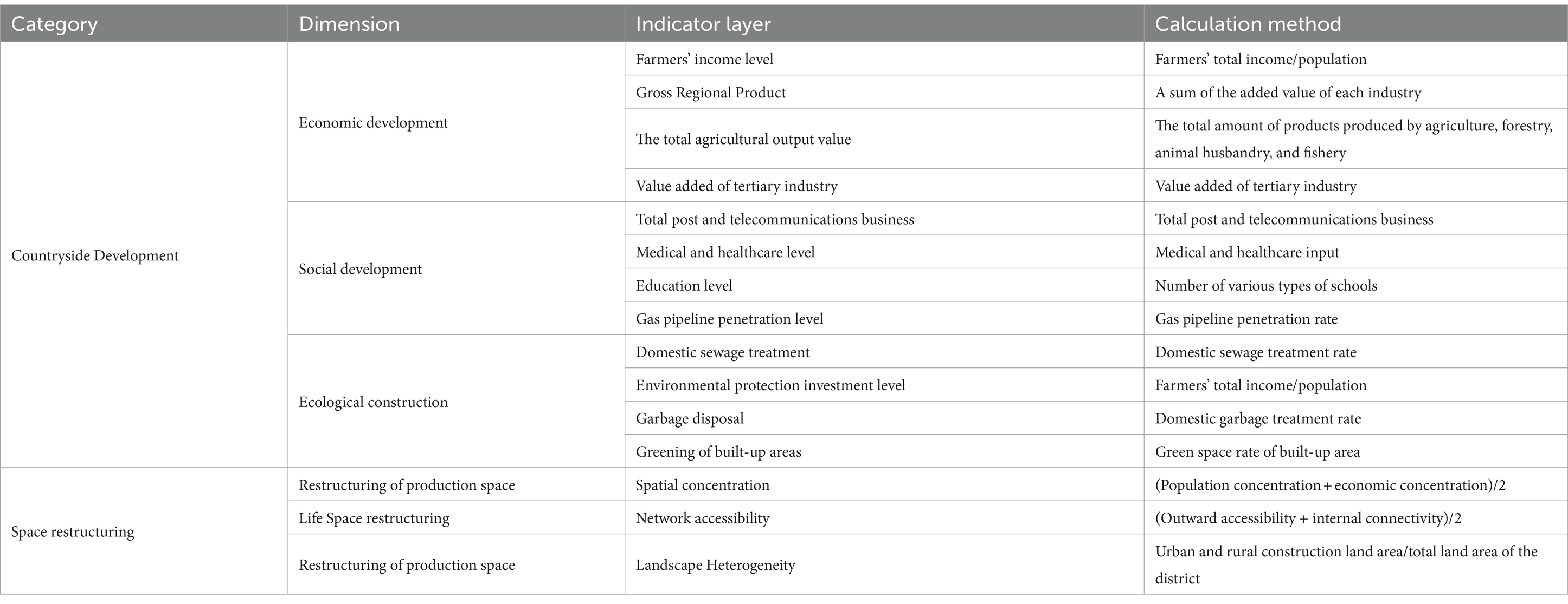
Table 1. Index system of rural development level and spatial restructuring intensity.
Using the entropy-weighted TOPSIS model, we measured the economic development level index, social development level index, ecological construction level index, and comprehensive development level index of X county in Zhejiang province from 2000 to 2020. Our goal was to establish a system of indices to assess the level of rural development, based on the principle of coherence of the range of gauges and accessibility of data for assessment indices. To this end, we identified four indicators to reflect the economic development level of the study unit: the level of farmers’ income, gross regional product, gross agricultural product, and added value of the tertiary industry. Additionally, we selected four indicators to reflect the social development level of the study unit, including the total amount of post and telecommunications services, level of medical and healthcare, level of education, and level of gas pipeline penetration. Furthermore, we identified four indicators to reflect the ecological construction of the study unit, including domestic sewage treatment, level of environmental protection investment, garbage treatment, and greening of built-up areas. Each of these indicators captures an essential aspect of the ecological construction of the study unit. We have analyzed the magnitude of change for each indicator, which reflects the intensity of change in the rural development level. By combining all these indicators, we were able to gain comprehensive insights into the rural development level of X county in Zhejiang province over a period of 18 years.
3.2.3 Measurement of the rural restructuring intensity index
The index evaluation system was constructed from three dimensions of production spatial restructuring, living spatial restructuring, and ecological spatial restructuring (Table 1), based on the entropy-weighted TOPSIS model, to measure the production spatial restructuring intensity index, living spatial restructuring intensity index, eco-logical spatial restructuring intensity index and comprehensive spatial restructuring intensity index in X County, Zhejiang Province from 2000 to 2020. Under the premise of following the same principles as the development level metric system, the system of indicators of evaluation at the level of rural spatial restructuring is built, and the spatial concentration index is selected to reflect the production spatial restructuring intensity of the study unit. Spatial concentration reflects the regional economic and demographic concentration, which is of practical importance for calculating the spatial intensity of the output of the unit of study; the network accessibility index is selected to reflect the spatial restructuring intensity of the home area of the study unit. The factors of network accessibility include the development level of transportation road network per unit area, which is closely related to human living conditions; the index of landscape heterogeneity is selected to reflect the intensity of ecological spatial restructuring of the study unit, and landscape heterogeneity is a major factor in coordinating land allocation and reasonable distance, which can reflect the level of ecological spatial restructuring of the study area more intuitively (Figure 1).
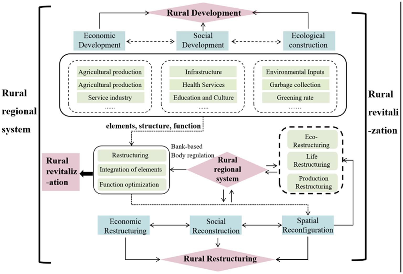
Figure 1. Theoretical framework diagram.
3.2.4 Coupling coordination evaluation method
Physical coupling refers to the interaction and influence between two or more systems through interconnectedness (Li et al., 2015). Achieving quality rural development requires promoting linkages and coordination among various systems, such as rural development and spatial restructuring (Gao et al., 2021). The organic combination of production, living, and ecological spaces is a crucial precondition and guarantee for the social, economic, and natural development of the countryside. It provides the necessary conditions for the development of economic, social, and natural systems, but it can also have negative effects. The objective representation of the coupling between the two systems focuses on the interaction between the elements of the system and the tendency of the system to develop toward complexity and sophistication. There can be a high degree of coupling even when the system is at a low level (Luo et al., 2020). Therefore, this study used the coupling coordination degree model to comprehensively evaluate the level of rural development and spatial restructuring, as well as the degree of coupling coordination in County X from 2000 to 2020, to reveal the synergy between the two systems. The degree of coupling C and the degree of coordination of coupling D were computed using this model.
Where C represents the coupling degree between two systems, the higher its value, the better the coupling coordination between the two surfaces; α and β are coefficients to be determined and add up to be equal to 1. According to the relevant studies with the contribution of two systems, α = β = 0.5 is taken in this study.
3.3 Research sources
In the present study, the county serves as the fundamental unit of analysis, and the study period spans from 2000 to 2020. The socioeconomic data used in this study were primarily sourced from the Quzhou City Statistical Yearbook, X County Statistical Yearbook, Zhejiang Province Yearbook, China Rural Statistical Yearbook, China Agri-cultural Yearbook, and other relevant county and city statistical yearbooks within the study area. All economic data were converted to comparable 2000 prices. Additional data were collected from relevant government websites between 2000 and 2020. Baseline geographic data was obtained from the Chinese Academy of Sciences Resource and Environment Data Center and associated data websites. Any missing data were completed via linear interpolation, and land use data were obtained from Landsat TM image interpretation data provided by the Resource and Environment Data Center of the Chinese Academy of Sciences (Figure 2).
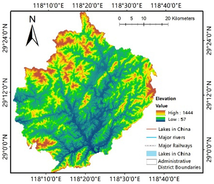
Figure 2. Geographical location map of X County.
4 Discussion
4.1 Pattern characteristics of rural development level
Between 2000 and 2020, the level of rural development in County X rose substantially. This was reflected in the shift of geographic functions from a lower level of consistent development to a higher level of diversified development due to the geographic proximity of the region (Long, 2014). The indices of economic and social development also dis-played important time-changing characteristics, which were closely related to the excellent ecological resources present in the region. For the study period, the average value of the level of integrated rural development in County X increased from 0.038 to 0.203, while the standard deviation was reduced from 0.316 to 0.270. Additionally, there was an increase in the absolute value of the skewness coefficient and peak coefficient, and the degree of outlier data increased. These findings indicate that the development process of the rural area system in County X is moving away from a low level of single development state and toward a high level of diversified development trend. Upon analyzing the three dimensions of economy, society, and ecology, we found that the average economic level of County X experienced the largest increase over the study period, rising from 0.038 to 0.203. The level of social development also increased from 0.044 to 0.156, while the level of ecological construction changed significantly from 0.070 to 0.226 (Table 2).
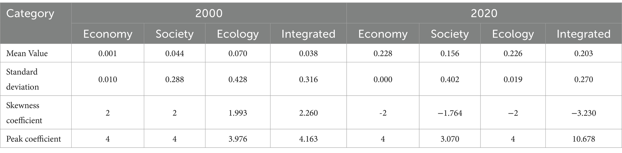
Table 2. Statistical table of development levels in County X, 2000–2020.
To comprehensively evaluate the development level of County X from 2000 to 2020, we assigned indicators and determined criteria for each indicator before applying factor analysis. This enabled us to calculate the level of rural development indices for each target level and criterion level and analyze the characteristics of the rural development level pattern of County X from 2000 to 2020 (Figure 3).
1. Over the past two decades, County X’s economic development has demonstrated a trend of “stable to good, high start and low decline, “with the comprehensive economic development index level increasing from 0.002 in 2000 to 0.385 in 2020 (Table 3). How-ever, the overall economic development rate has experienced fluctuations with an “in-creasing-decreasing-stable” trend. Analysis of major economic indicators revealed that in 2009, County X experienced its highest economic development rate in 20 years, with the economic growth rate surpassing the provincial and municipal averages, and exhibiting a positive trend in terms of operating quality and growth. However, after 2015, the economic situation became increasingly complex and challenging, leading to a severe and challenging development mission for the leadership team. To address these challenges, the leadership team promoted comprehensive industrial strength, green development, “a belt of four platforms” economic construction, and a high level of county governance to foster high-quality development, gradually achieving stable and healthy improvements in economic quality and life satisfaction for the people of County X.
2. The overall social development level of X County follows a flattened, inverted “S” pattern curve, where each cycle continues the trend of the previous one. After each complete cycle, the social development level enters a stage of rapid upgrading, followed by a gradual slowdown or even stagnation. The third stage shows a saturation of progress, signifying a shift to a steady state of development. From 2008 to 2011, the trend of social development level in X County mirrored that of ecological construction, as rural agricultural development led to pollution and a decline in rural habitat quality. This has resulted in a lagging trend for social development. The decreasing trend in rural social development levels between 2017 and 2020 can be attributed to the imbalance of the urban–rural dichotomy, the adjustment of basic education facilities’ layout, and the market-oriented reform of higher education. The solidified hukou registration system in X County has restricted population transfer between rural and urban areas, thereby increasing the burden of population support. The reforms such as “school abolition” and “school consolidation, “and structural adjustments in the layout, have led to a decrease in the number of primary and secondary schools in rural areas of County X, causing a concentration of spatial layout. The confluence of economic, educational, and household registration factors has culminated in a state of unequal social development in X County, necessitating an immediate implementation of requisite interventions to promote harmonious growth.
3. The ecological construction level of X County has exhibited an oscillatory trend in an upward direction, surpassing the level of socio-economic advancement in particular quantitative values, due to the county’s unique ecological resources and environment. Despite the various ecological accomplishments and honors, including its designation as a showcase county for national ecological civilization-building, X County has faced the challenge of decreasing ecological construction levels between 2007 and 2010, attributed to the resource consumption and resulting environmental degradation posed by the expansion of social industry and economy. To counteract this ecological deterioration, X County, led by its county government, implemented specialized industries for cultivating developmental plans, prioritizing ecological considerations, green development, and sustainable development to realize a thriving society with pleasant landscapes, affluence, and revitalization. In 2014 and 2020, X County achieved full coverage of its ecological towns and its first round of “Fresh Air Demonstration Areas,” explored the national park system pilot, and strives to attain the dual targets of healthy ecological civilization and synchronized socio-economic development of the county.
4. The comprehensive development level of X County has exhibited a fluctuating, yet an upward developmental trend, with a rapid change of the development level score from 0.104 in 2000 to 0.746 in 2020. The unique location and natural resources of X County have earned it the distinction of being hailed as “China’s natural oxygen bar,” with the improvement of its developmental level being intrinsically linked to its enviable ecological resources. The available data reveal the period between 2000 and 2010 as the phase where the level of ecological construction and lack of resource constraints predominantly controlled the comprehensive development level of X County. In contrast, since 2010, the current situation manifests a more nuanced perspective, with the joint effect of economic development and ecological construction on comprehensive development taking center stage. In 2006, X County committed to cultivating specialized industrial clusters, thereby greatly enhancing its comprehensive capability, leading to ecological damage. However, the excessive growth of “two-silicon” enterprises and the development of electric light sourcing, pencil, bamboo, and wood products industries led to soil erosion and environmental pollution, leading to a reduction in X County’s comprehensive developmental level index, with regression evident in 2009. Notwithstanding, X County has continually increased its ecological conservation efforts through increased soil erosion control system and ecological river construction, promoting local economic development uniquely aligned with environmental protection, thereby achieving steady, progressive enhancement in its comprehensive developmental level coinciding with its comprehensive rural area’s development.
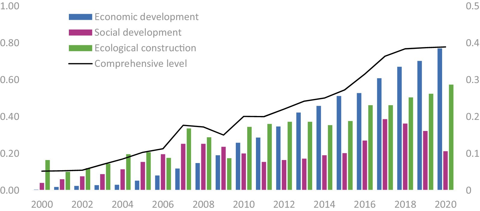
Figure 3. Map of rural development levels in County X, 2000–2020.
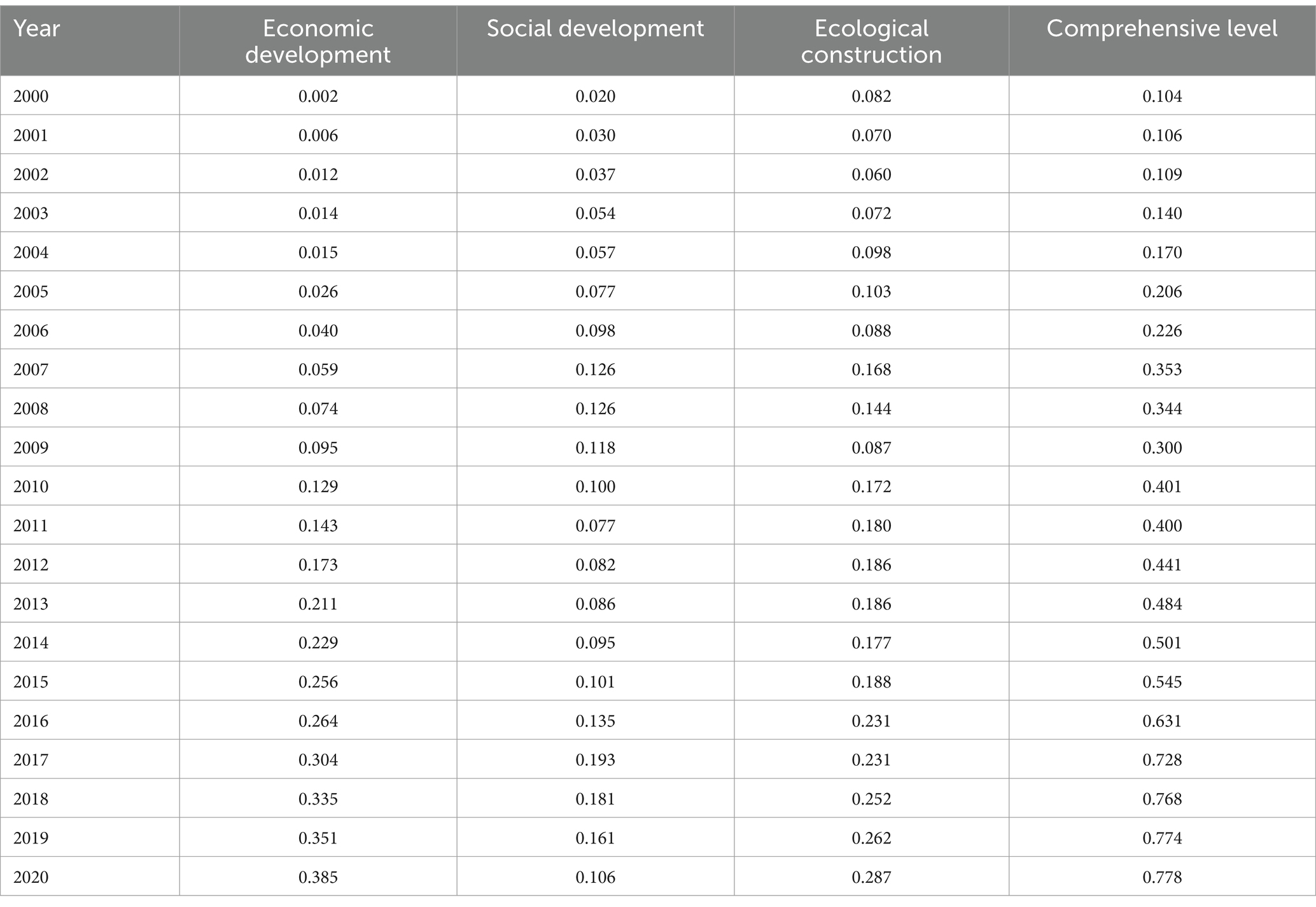
Table 3. Development level index scores for County X, 2000–2020.
4.2 Pattern characteristics of spatial restructuring intensity of countryside
The current research methodology involves the application of the entropy method to calculate the weights of various indicators in the “Three Lives” spatial restructuring section of Table 1. The fractal dimension and comprehensive index of rural spatial re-structuring are derived via weighting techniques, and the outcomes are elucidated in Figure 3 and Table 4. The spatial redesign of rural areas within the research domain exhibits temporal continuity and stage nonlinearity, with the general restructuring undergoing a process of “decentralized, equalized, differentiated development.” The average intensity of production, living, and ecological spatial restructuring is steadily increasing, with the three domains moving closer toward a stable and balanced state, a scenario that aligns with the current developmental conditions.
(1) The rural areas of X County continue to experience spatial restructuring, and the spatial restructuring index continues to rise. Between 2000 and 2020, Rural County X’s Global Spatial Restructuring Level Index increased from 0.124 to 0.969. Among them, the index of spatial restructuring of production increased from 0.004 to 0.385, and the index of spatial restructuring of living and spatial restructuring of ecology increased from 0.119 and 0.411 to 0.325 and 0.259. Spatial restructuring of rural areas is a process of spatial transformation and development of rural areas, tracing the spatial reconfiguration indicators related to the “Production-Living-Ecological” and their changes: the characteristics of the rural landscape in County X have changed significantly during the study period and are being continuously transformed and upgraded. The restructuring of rural production space is predominantly witnessed by an augmentation in population concentration and economic concentration. Alternatively, the restructuring of the rural living space is primarily reflected by an increase in the total area of urban and rural building land, coupled with the gradual intensification of the land. Lastly, the restructuring of rural ecological space is chiefly manifested by an improvement in the connectivity of ecological networks. Based on these findings, substantial changes have occurred in the components and structure of the regional rural system, which constantly promotes the transformation and development of rural regional functions.
(2) The evolution of the “Production-Living-Ecological” space serves as a critical medium for rural spatial restructuring, representing the projection of politics, economy, society, culture, and nature on the regional space. Rural spatial reconstruction in X County exhibits phased and nonlinear characteristics, and the overall form of spatial reconstruction has undergone a process of “decentralization, equalization, differentiation development” (He, 2012). As a node, around 2009, the contribution rate of rural ecological space reconstruction decreased significantly in the early stage and slowed down in the later stage. The contribution rate of rural living space reconstruction tended to increase uniformly in the early stage and remained relatively stable in the later stage. The fluctuation and changes in the early stage and the increased amplitude in the later stage of rural production space reconstruction tended to be calm. The adjustment of industrial structure, the level of industry technology, the size of input factors, and the advantages of natural resources all have a significant impact on the spatial demand and competitiveness of rural “Three Lives” areas under county units. Before 2009, the reconstruction of rural ecological space in X County was in a dominant and core position, which was in line with X County’s unique ecological and environmental resource advantages. After 2009, the growth rate of rural production space reconstruction became relatively uniform, and the reconstruction of rural social space and ecological social space tended to stabilize. This is consistent with the fact that X County had excellent economic operation quality and was growing steadily in 2009.
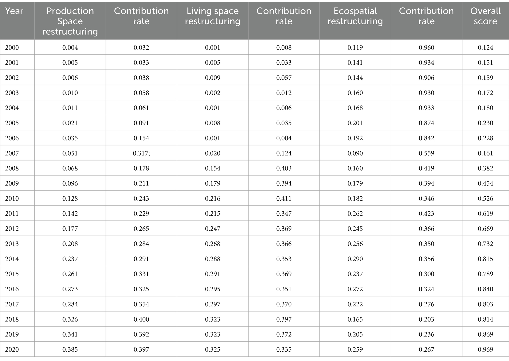
Table 4. Change in restructuring level index in County X, 2000–2020.
4.3 Coupling and coordination relationship between the rural development level and spatial restructuring
By establishing a coupling relationship model between the rural development level and spatial restructuring level in County X, the degree of coupling between rural development and spatial restructuring in County X is estimated to be between 0.4 and 0.5 between 2000 and 2020. The level of coordination between the rural development subsystem and the space restructuring subsystem is constantly evolving. However, the simple calculation of the degree of coupling does not make it easy to identify the coupling between development and space under low-intensity restructuring and high-intensity restructuring. To address this issue, the degree of coupling coordination model was used to measure the development subsystem and the space restructuring subsystem. The measurement results were classified into the five following types based on the existing study (Li, 2023) and the specific development situation of X County: severe disorder (0.200 < D ≤ 0.300), moderate disorder (0.300 < D ≤ 0.400), mild dysregulation (0.400 < D ≤ 0.500), primary coordination (0.500 < D ≤ 0.600), and good coordination (0.600 < D ≤ 0.700).
The classification of the coupling coordination degree into five categories helps to systematically evaluate the relationship between rural development and spatial restructuring, offering a clear understanding of their interactions and the extent of their integration. The ranges are defined as follows:
Severe Disorder (0.200 ≤ D < 0.300): This range indicates a very low level of coordination between rural development and spatial restructuring, where the systems are largely independent and there is significant misalignment. This could result from severe socio-economic disparities, lack of infrastructure, or environmental degradation.
Moderate Disorder (0.300 ≤ D < 0.400): In this range, there is some interaction between the systems, but it is insufficient for meaningful integration. Challenges such as underdeveloped economic sectors, insufficient social services, and moderate environmental issues might characterize this stage.
Mild Disorder (0.400 ≤ D < 0.500): This level reflects a growing interaction between rural development and spatial restructuring, yet significant disparities and inefficiencies remain. Improvements in infrastructure, economic diversification, and social services are necessary to progress further.
Primary Coordination (0.500 ≤ D < 0.600): At this stage, the systems are beginning to work together more effectively, showing initial signs of synergistic development. Coordination is improving, with better infrastructure, economic integration, and environmental management leading to enhanced rural development.
Good Coordination (0.600 ≤ D < 0.700): This highest range indicates a strong, positive interaction between rural development and spatial restructuring. The systems are well-aligned, leading to sustainable development characterized by economic vitality, social equity, and environmental sustainability. Effective policy implementation and continuous improvement drive this high level of coordination (Table 5).
1. The coordination of the coupling shows a constant increase at low levels with significant temporal heterogeneity. Between 2000 and 2020, the degree of coupling of the rural development subsystem with the space restructuring subsystem in County X remained relatively stable. Over time, the degree of coupling shifted from primarily low-level and antagonistic coupling to the early cooperation and collaboration phases, and continues to be in a crushing phase. The linear trend growth and improvement in the value of coordinated development reflects the ideal state of interaction among several systems in County X over the study period, and is the presentation of diverse development results and the global optimization and enhancement of County X. As shown in Figure 4, between 2008 and 2009, with rapid economic and social development in County X over the study period, ecological and environmental capacity was coerced and faced greater challenges, hindering the benign relationship and coordinated development of social development and spatial restructuring of Eco-Living Production, resulting in a slow upward trend (Li et al., 2019). After 2010, X County’s overall level of development significantly increased, with the contribution of output and life continuing to increase. The general trend of the degree of role between the two subsystems also increased, and the trend in the level of coupling and coordination became more evident. The coupling coordination degree belongs to the concept of time, and the mean value of the degree of coordination of coupling of the two sub-systems of County X over the study period shows a steady increase. Following the degree of coordination and the characteristics of the change, it can be seen that the degree of linkage coordination for County X during the study period ranges from 0.238 to 0.659, exhibiting a homogeneous linear increase. With an improvement in productivity and economic development, the interaction between the two systems gradually increases, and the orderliness of the development direction improves. However, a complete comparison of the current level of coordination of County X as a whole is weak and has not yet achieved the benign high coordination state (Figure 5).
2. The type of coupling coordination changes to benign optimization with significant stage heterogeneity. Between 2000 and 2020, the overall coordination relationship between the level of rural development and the level of spatial restructuring in County X evolved from severe dysfunction to good coordination. The development history can be further subdivided into four stages.(1) Between 2000 and 2004, the overall level of economic and social development in County X was low, and the level of economic and social development fell significantly behind environmental development. The coordination between the rural development subsystem and the spatial restructuring subsystem was the lowest, and the interaction was weak. The mean level of coupling coordination degree was between 0.238–0.296, indicating severe dysfunction. (2) From 2005 to 2011, X County focused on cultivating special industry clusters and promoting equalization of core public services, leading to a breakthrough and an enhancement of economic and social development and a significant increase in the county’s total population. The coordination of the coupling of the two subsystems changed from moderate to slight dissonance, with the average level of coordination between 0.330 and 0.499, remaining in the basic dissonance stage, and overall coordination of coupling remained weak and delayed (Li et al., 2014). (3) From 2012 to 2015, both subsystems reached a stage of coordination of light between them, and their interactions tended to intensify. At this stage, with the thorough implementation of the development strategy of “ecological county, characteristic county” and the change in the political context, the overall coordination of rural development and spatial restructuring tended to be coordinated and was nearing the end of the adversarial phase.(4) Since 2016, the government of County X took “the pursuit of progress within the framework of stability, the pursuit of activity during change, the pursuit of good in transformation” as the overall orientation of the county’s work, and adjusted the development strategy system with the complex external situation, steadily improving the economic construction and ecological construction, and optimizing industrial conversion and structural adjustment. The level of integration of the two subsystems has maintained a steady and positive trend toward a good coordination stage, and rural development and spatial restructuring of County X tend to be coordinated, with the mean value of coupling coordination above 0.573.
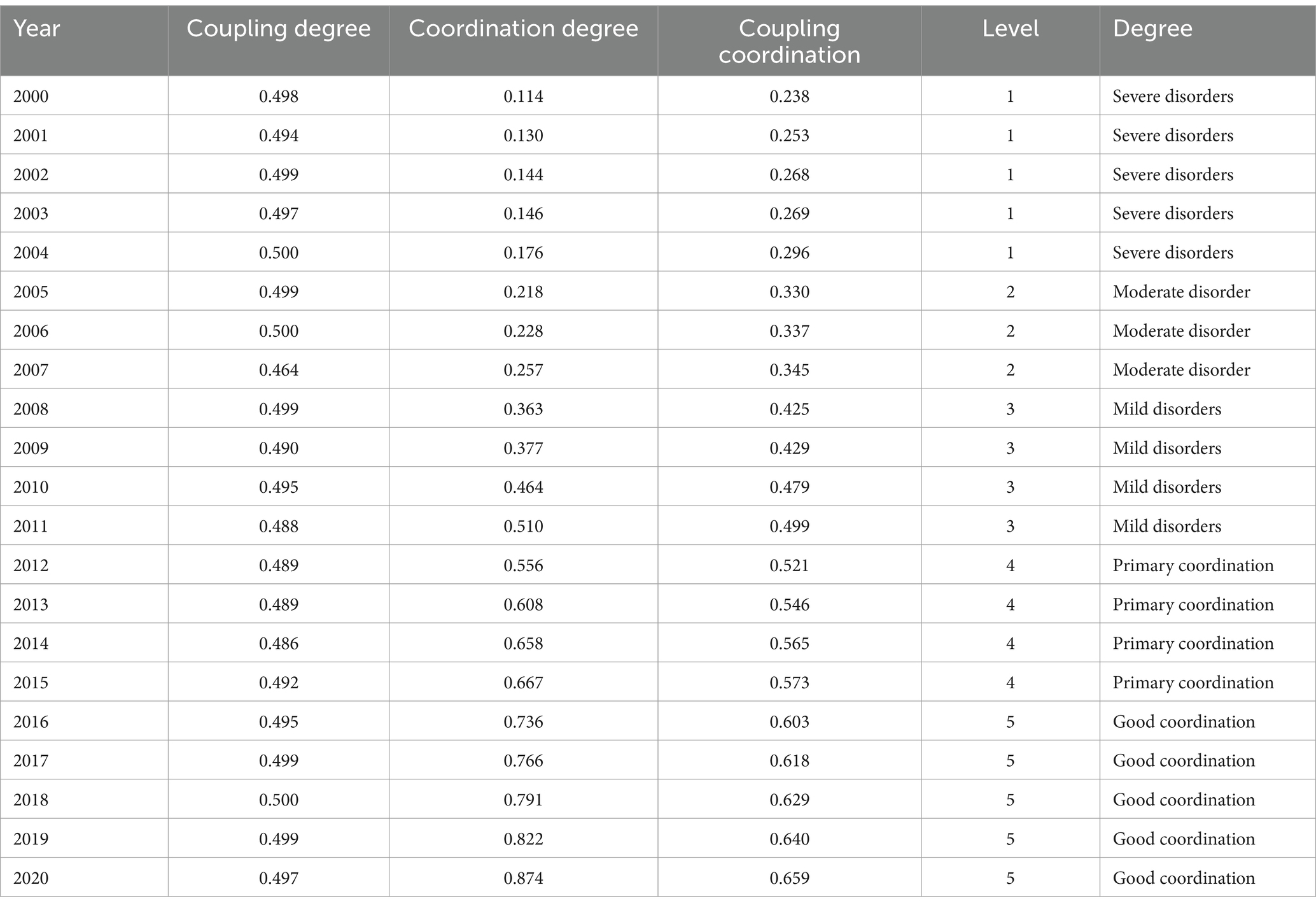
Table 5. Coupling coordination measures for County X, 2000–2020.
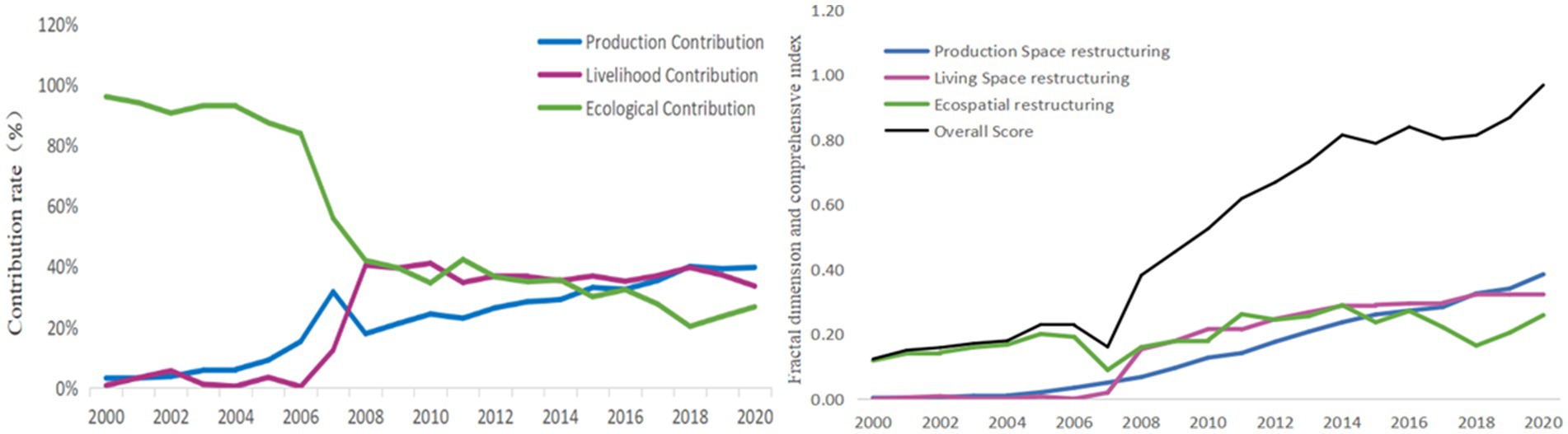
Figure 4. Trends in rural restructuring index and its structure in County X, 2000–2020.
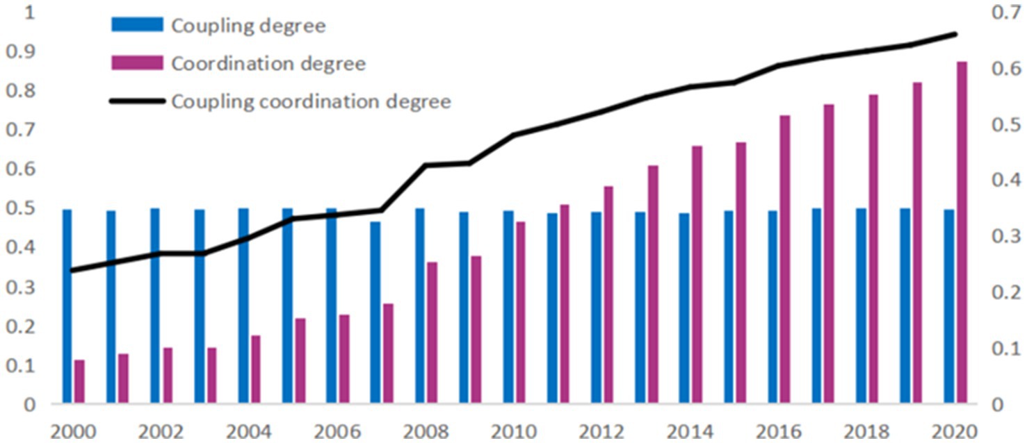
Figure 5. Changes in the coupling coordination between rural development and spatial restructuring in County X, 2000–2020.
5 Conclusion and suggestion
The core purpose of rural revitalization is to create a highly coupled and coordinated state among all elements in the rural regional system (Liu, 2018), which depends on the combination of economic, social, ecological, and spatial aspects. This study analyzed the rural development model and spatial restructuring characteristics of County X over the period 2000–2020 using the TOPSIS model backed by the entropy value method and decoded the County of X rural revitalization pathway using the degree of coordination combining rural development and spatial restructuring sub-systems. The natural resources and human conditions of County X are diverse, which allows for diversified rural development through integrated planning and regional systems. The research concept and methodology integrate the spatial coupling of rural regional function and “Production-Living-Ecological,” and the research results provide baseline information to decipher the path of rural revitalization at various degrees of coupling and promote sustainable rural development (Table 6). The exchange, change, and role of the elements of the grain system were also considered in the analysis, providing a comprehensive understanding of the rural revitalization process in County X.
1. Rural areas with low levels of coupling and coordination need to focus on regional resource advantages, optimize the rural industrial structure, and develop leading industries. Currently, most rural development in China is limited by natural constraints and underdeveloped utilization, such as single natural resources and low efficiency in utilizing ecological resources. Large areas of old-growth forests and unused fertile resource reserves are ubiquitous. “Greening” and “characterizing” should be adopted as the starting point for optimizing industrial structure based on local resource characteristics and regional advantages. Different regions, including the “Sherao Barrier” landscape, five types of topographic features, revolutionary base areas’ red culture, and folk art, possess distinct cultural heritage that needs to be explored. To revitalize ecological resources, new trends in rural economic development, such as elderly care and health preservation, green tourism, and ecological culture, need to be developed through “densification” and “prioritization.” For instance, abundant mineral resources can be utilized for cement, bricks, and tiles production, and the scientific and macro-industrial development system can be optimized through reasonable development, utilization, planning, and design. This will provide resource support and basic guarantees for the tertiary industry’s development. In contrast, superior soil and water resources can promote the development of industries such as grain and oil, tea, traditional Chinese medicine, and fruits and vegetables, while accelerating the construction of an ecological industrial system, increasing the added value of agricultural production, and promoting the highly integrated complex of primary and tertiary industries. “Organization” and “integration” should be the foundation of rural revitalization, and strengthening grassroots organizations and improving infrastructure are effective means to implement rural revitalization strategies.
2. High coupling and coordination rural areas need to coordinate ecological and environmental protection, improve the spatial layout of rural areas, and create replicable models. China’s ecological deficit is gradually getting worse, therefore for rural spatial restructuring and productivity expansion, the cornerstone for survival is land resources and ecological resources. The countryside faces enormous problems and tests in the rational distribution of land resources and the rational organization of land use, and it is crucial to “systematize” and “ecology” rural development. On the one hand, areas with a high level of ecological construction must develop environmentally sustainable development ideas, strengthen ecological protection and the rational use of resources, pay attention to soil erosion control and the ecological construction of rivers in the construction and development of special industrial clusters, developing ecologically sensitive areas sensibly, actively exploring a diverse model of spatial development restructuring, and building a green sample with a beautiful environment, thriving industries and rich farmers. Based on the concept of “diversification” and “coordination” of rural development, we will expand the intense use of the three living spaces and truly rejuvenate ecological resources. On the other hand, as society continues to progress and farmers’ income generation targets continue to rise, rural development must be “upscale” and “experienced” to create the beautiful countryside of China.
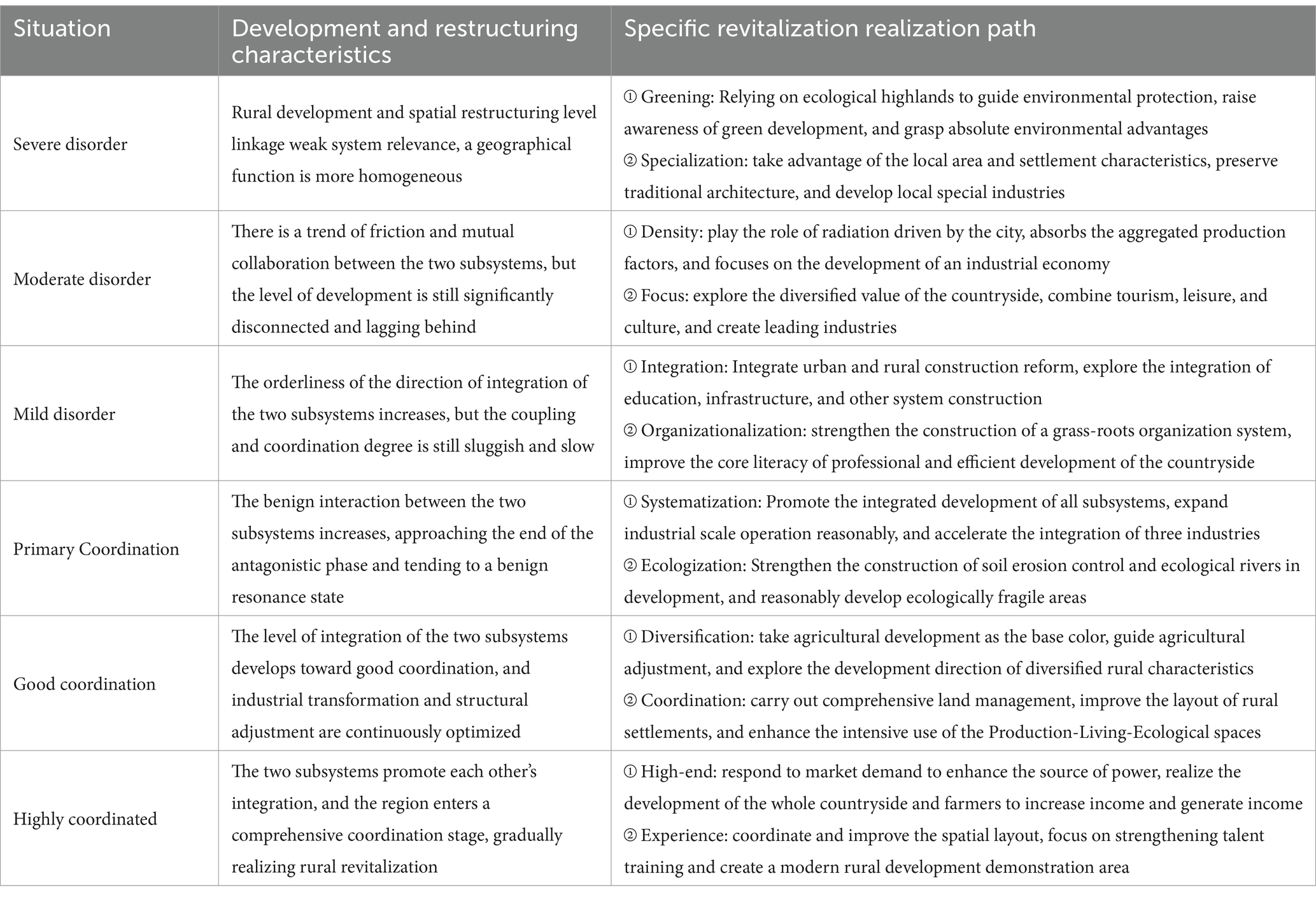
Table 6. Rural revitalization paths under different coupling coordination degrees.
By demonstrating the effectiveness of using the coupling coordination degree model to analyze and enhance the synergy between economic, social, and ecological systems, this study provides a replicable framework for assessing and promoting rural revitalization. The findings underscore the importance of integrated development strategies that consider the unique geographical and socio-economic conditions of each region. This research not only highlights the critical role of spatial restructuring in achieving diversified and sustainable rural development but also serves as a benchmark for policymakers and researchers aiming to foster harmonious growth in other rural areas facing the challenges of industrialization and urbanization. This research is also crucial for understanding the complexities of rural development in the context of fast urbanization, offering insights into effective policy measures and sustainable development practices that can be applied both within China and globally.
Data availability statement
The original contributions presented in the study are included in the article/supplementary material, further inquiries can be directed to the corresponding author/s.
Author contributions
SZ: Writing – original draft. YC: Investigation, Writing – review & editing. XZ: Writing – review & editing.
Funding
The author(s) declare that financial support was received for the research, authorship, and/or publication of this article. This research was funded by the Comprehensive Territorial Spatial Planning for Taishun County (2020–2035) (No. 2019330).
Conflict of interest
SZ and XZ were employed by the Zhejiang University Urban Rural Planning Design Institute Co, Ltd.
The remaining author declares that the research was conducted in the absence of any commercial or financial relationships that could be construed as a potential conflict of interest.
Publisher’s note
All claims expressed in this article are solely those of the authors and do not necessarily represent those of their affiliated organizations, or those of the publisher, the editors and the reviewers. Any product that may be evaluated in this article, or claim that may be made by its manufacturer, is not guaranteed or endorsed by the publisher.
References
Chen, F., Yu, M., Zhu, F., Shen, C., Zhang, S., and Yang, Y. (2018). Rethinking rural transformation caused by comprehensive land consolidation: insight from program of whole village restructuring in Jiangsu Province, China. Sustainability 10:2029. doi: 10.3390/su10062029
Gao, Y., Li, H., and Song, Y. (2021). Interaction relationship between urbanization and land use multifunctionality: evidence from Han River basin, China. Land 10:938. doi: 10.3390/land10090938
He, X. (2012). On the regional differences in rural areas in China—a perspective of village social structure. Open Age 10, 108–129.
Huang, Q., Xu, J., Qin, H., and Gao, X. (2018). Understanding land use and rural development in the National Scheme of village relocation and urbanization in China: a case study of two villages in Jiangsu Province. Sustain. For. 10:3227. doi: 10.3390/su10093227
Li, H. (2023). The research of marginalization of agricultural land. Beijing, China: China social sciences press.
Li, X., Guo, Y., Tian, S., Bai, Z., and Liu, H. (2019). The Spatio-temporal pattern evolution and driving force of the coupling coordination degree of urban human settlements system in Liaoning Province. Sci. Geogr. Sin. 39, 1208–1218. doi: 10.13249/j.cnki.sgs.2019.08.002
Li, H., Huang, X., Kwan, M.-P., Bao, H. X. H., and Jefferson, S. (2015). Changes in farmers’ welfare from land requisition in the process of rapid urbanization. Land Use Policy 42, 635–641. doi: 10.1016/j.landusepol.2014.09.014
Li, T., Long, H., Tu, S., and Wang, Y. (2015). Analysis of income inequality based on income mobility for poverty alleviation in rural China. Sustain. For. 7, 16362–16378. doi: 10.3390/su71215821
Li, Y., Wang, J., and Liu, Y. (2014). Spatial pattern and influencing factors of the coordination development of industrialization, informatization, urbanization and agricultural modernization in China: a prefecture level exploratory spatial data analysis. Acta Geograph. Sin. 69, 199–212. doi: 10.11821/dlxb201402005
Li, T., Wang, Y., and Liu, C. (2021). Research on identification of multiple cropping index of farmland and regional optimization scheme in China based on NDVI data. Land 10:861. doi: 10.3390/land10080861
Liu, Y. (2018). Research on the urban-rural integration and rural revitalization in the new era in China. Acta Geograph. Sin. 73, 637–650. doi: 10.11821/dlxb201804004
Liu, Y. S. (2018). Introduction to land use and rural sustainability in China. Land Use Policy 74, 1–4. doi: 10.1016/j.landusepol.2018.01.032
Long, H. L. (2014). Land consolidation: an indispensable way of spatial restructuring in rural China. J. Geogr. Sci. 24, 211–225. doi: 10.1007/s11442-014-1083-5
Long, H., Kong, X., Hu, S., and Li, Y. (2021). Land use transitions under rapid urbanization: a perspective from developing China. Land 10:935. doi: 10.3390/land10090935
Long, H., and Liu, Y. (2016). Rural restructuring in China. J. Rural. Stud. 47, 387–391. doi: 10.1016/j.jrurstud.2016.07.028
Long, H., and Tu, S. (2017). Rural restructuring in China: theory, approaches and research prospect. Acta Geograph. Sin. 72, 563–576.
Long, H., Zhang, Y., Ma, L., and Tu, S. (2021). Land use transitions: Progress. Challenges Prospects Land 10:903. doi: 10.3390/land10090903
Luo, Y., Xiang, P., and Wang, Y. (2020). Investigate the relationship between urbanization and industrialization using a coordination model: a case study of China. Sustain. For. 12:916. doi: 10.3390/su12030916
Lyu, L., Gao, Z., Long, H., Wang, X., and Fan, Y. (2021). Farmland use transition in a typical farming area: the case of Sihong County in the Huang-Huai-Hai plain of China. Land 10:347. doi: 10.3390/land10040347
Meyfroidt, P., Lambin, E. F., Erb, K. H., and Hertel, T. W. (2013). Globalization of land use: distant drivers of land change and geographic displacement of land use. Curr. Opin. Environ. Sustain. 5, 438–444. doi: 10.1016/j.cosust.2013.04.003
Nelson, P. B. (2001). Rural restructuring in the American west: land use, family and class discourses. J. Rural. Stud. 17, 395–407. doi: 10.1016/S0743-0167(01)00002-X
Nie, C. J., Liu, Z. W., Yang, L. S., and Wang, L. (2022). Evaluation of spatial reconstruction and driving factors of tourism-based countryside. Land 11:1446. doi: 10.3390/land11091446
Tu, S., and Long, H. (2017). Rural restructuring in China: theory, approaches and research prospect. J. Geogr. Sci. 27, 1169–1184. doi: 10.1007/s11442-017-1429-x
Tu, S., Zheng, Y., and Long, H. (2020). Spatio-temporal pattern of rural development and restructuring and regional path of rural vitalization in Guangxi. China. Acta Geogr. Sin. 75, 365–381. doi: 10.11821/dlxb202002011
Woods, M. (2005). Rural geography: processes, responses and experiences in rural restructuring; sage: London. UK, 26–48.
Yu, B., Lu, Y., and Zeng, J. (2017). Progress and prospect on rural living space. Sci. Geogr. Sin. 37, 375–385.
Zhang, B., Sun, P., Jiang, G., Zhang, R., and Gao, J. (2019). Rural land use transition of mountainous areas and policy implications for land consolidation in China. J. Geogr. Sci. 29, 1713–1730. doi: 10.1007/s11442-019-1687-x
Zhao, Y., Leng, H., Sun, P., and Yuan, Q. (2018). A spatial zoning model of municipal administrative areas based on major function-oriented zones. Sustain. For. 10:2976. doi: 10.3390/su10092976
Keywords: rural restructuring, rural development, coupling and coordination, rural revitalization, rural regional system
Citation: Zhang S, Chen Y and Zhang X (2024) Spatial restructuring and development characteristics of villages and the revitalization path: a case study of the X County of Zhejiang Province in China. Front. Sustain. Cities. 6:1441750. doi: 10.3389/frsc.2024.1441750
Edited by:
Guoliang Xu, Jiangxi University of Finance and Economics, ChinaReviewed by:
Yu Ting Xu, Anhui Normal University, ChinaHua Lu, Jiangxi University of Finance and Economics, China
Copyright © 2024 Zhang, Chen and Zhang. This is an open-access article distributed under the terms of the Creative Commons Attribution License (CC BY). The use, distribution or reproduction in other forums is permitted, provided the original author(s) and the copyright owner(s) are credited and that the original publication in this journal is cited, in accordance with accepted academic practice. No use, distribution or reproduction is permitted which does not comply with these terms.
*Correspondence: Xin Zhang, emhhbmd4aW4wOTEzMjAyNUAxMjYuY29t