 Francesco Tajani
 Pierluigi Morano2
 Felicia Di Liddo
 Debora Anelli
 Francesco Sica
94% of researchers rate our articles as excellent or good
Learn more about the work of our research integrity team to safeguard the quality of each article we publish.
Find out more
ORIGINAL RESEARCH article
Front. Sustain. Cities , 22 December 2023
Sec. Sustainable Infrastructure
Volume 5 - 2023 | https://doi.org/10.3389/frsc.2023.1314967
This article is part of the Research Topic New frontiers in evaluation, management, and technologies for sustainable cities View all 6 articles
Introduction: The industrial activity constitutes one of the most driving sectors of a nation, as it is often considered at the center of public debate as the fulcrum of development policies. However, considering the climate impacts generated, many industries have necessarily changed, relocated, and/or interrupted their production. Due to the connection of industrial sites with the socio-economic, environmental, and health systems of cities, the real estate market dynamics can be differently affected by the presence of polluting industrial sites. With reference to the Italian context, the goal of the research is to, firstly, verify whether there is a functional relationship between the presence of polluting industrial sites and the residential real estate market dynamics, for then determining its type and the extent of purchase price affection.
Method: The proposed logical-evaluative model is based on the application of an econometric technique for investigating the significance of the industrial sites on the residential real estate dynamics through a set of technological, locational, and health variables.
Results: The obtained results show that the total surface area of the polluting sites, the activity level and the industrial plant opening date are among the most relevant variables, instead the accessibility to the industrial site does not influence the real estate market dynamics.
Discussion and practical implications: The main practical implication of the present research consists of the possibility to provide a support for the activation of strategies aimed at adopting sustainable development models in the industrial sector.
In the context of global urban regeneration initiatives, the recovery of sizable disused industrial sites for potential future reuse is a key issue (Dasgupta and Tam, 2009). In fact, the remediation and renovation initiatives of contaminated sites represent a good choice in terms of the environment, economy and society (Green, 2018), even if the high remediation costs and bureaucratic complexity are often considered the most significant obstacles of such initiatives. Given the common technical, regulatory and economic critical issues in the development of regeneration initiatives aimed at introducing new activities - residential, commercial, artisanal, office or functional mix - on areas previously used for industrial production or for the storage of products from the agri-food chain -, in recent decades, public attention toward environmental issues has increased (Alker et al., 2000). With the advent of sensitivity to ongoing climate changes and the increase in awareness in various academic, political and professional fields of having access to natural resources in limited quantities, a progressive desire to move industries toward peripheral urban areas and away from real estate residential properties has inevitably established.
Numerous studies and research have highlighted how the increase in pollution levels, the emergence of diseases, the increase in the mortality rate and the depopulation of some urban areas are all dynamics attributable to the presence of polluting industrial sites. According to the analysis carried out by the European Environmental Agency (EEA), the largest industrial plants contribute a significant share of total emissions of major air pollutants and greenhouse gases, including the release of pollutants into water and soil, the production of toxic and radioactive waste and the reduced consumption of energy from renewable sources (European Environmental Agency, 2020). However, thanks to the contributions deriving from a series of factors such as stricter environmental regulations, progress in energy efficiency, a general trend in European industry toward the abandonment of heavy, more polluting production, and the spread of more responsible industrial models, the environmental impact of European industry has improved in recent years.
There are currently five European regulations aimed at limiting industrial pollution: the European Parliament Council Directive 2010/75/EU (2010) on industrial emissions, the European Parliament Council Directive 2015/2193/EU (2015) and of the Council of 25 November 2015 on the limitation of emissions of certain pollutants into the air from medium combustion plants, the European Parliament Council Directive 2009/125/EC (2009) establishing a framework for the setting of ecodesign requirements for energy-related products, the European Parliament Council Directive 2003/87/EC (2003) establishing a scheme for greenhouse gas emission allowance trading within the Community and amending European Parliament Council Directive 2000/60/EC (2000) of the European Parliament and of the Council of 23 October 2000 establishing a framework for Community action in the field of water policy, the European Council Directive 91/271/EEC (1991) concerning urban waste-water treatment.
As part of the strategic measures established and promoted at European level, the ecological transition is one of the pillars of the European Commission (2019), Next Generation EU (2022) in connection with the Green Deal and, in the Italian context, one of the fundamental components of the National Recovery Resilience Plan (NRRP) (2022). The ecological transition plan refers to a significant transformation process aimed at neutralizing all those phenomena considered harmful to the ecosystem and human wellbeing. 71.6 billion euros of European funds have been dedicated to this goal achievement, divided into three missions articulated into a set of components for different purposes. Within this framework, an essential aspect concerns the costs of damage caused by air pollution. It is estimated that in 2017, air pollution emitted by large industrial sites in Europe cost society between 277 and 433 billion euros. This is equal to about 2–3% of the European Gross Domestic Product (GDP) and is higher than the total economic output of many individual member states in that year. The main polluting facilities are in Germany, the United Kingdom, Poland, Spain and Italy. When these costs are compared to GDP - as an indicator of relative environmental performance per unit of national economic production - the top five countries are Estonia, Bulgaria, the Czech Republic, Poland and Slovakia.
The consequent delocalization, however, has modified the socio-economic sub-stratum of cities and urban fabrics, both in terms of modification of the level of attractiveness in the work-employment context, and in terms of the spread of degraded and now contaminated urban areas due to former abandoned industrial sites (Williams and Dair, 2007). These areas usually result from the loss of once rich inner city districts, leaving behind environmentally risky properties and buildings that can represent significant obstacles in terms of development. They are generally defined as abandoned structures and premises that are totally or partially decommissioned and no longer serve their purpose (Schädler et al., 2011). According to Accordino and Johnson (2000) and Yount (2003), brownfields are real estate properties that are underutilized, neglected, and perhaps contaminated (Accordino and Johnson, 2000; Yount, 2003; Anelli and Tajani, 2022). Several brownfields still exist because they were once used for industrial, agricultural, military, transportation, religious, or communal purposes but were no longer economically viable (Skrabal, 2020; Turečková et al., 2021). Brownfields, however, stay to be a crucial component of both urban and rural areas, therefore they must be carefully considered when planning development (Dubé et al., 2018; Navrátil et al., 2020; Anelli and Tajani, 2023). Although they are a fairly specialized aspect of spatial architecture in post-industrial areas, brownfields are unquestionably important (Martinat et al., 2017). Living near a brownfield or having a property there has disadvantages that aren't always seen favorably. These locations are frequently associated with a number of detrimental effects, involving social, environmental, economic, health, and safety challenges (Accordino and Johnson, 2000). Gaining a better grasp of how brownfield sites affect the values of surrounding properties is the main goal of the following work.
Through the analysis of the real estate market dynamics, it is possible to highlight the influence that the pollution sites have on the demand and supply composition, in order to provide essential basis for the adoption of urban environment improvement strategies. Regardless of whether a property is adjacent to a brownfield, its location beneath communities or regions - whether central or remote - has a substantial influence on its value (Bacot and O'Dell, 2006). If this influence is detrimental, it causes an adverse effect for the owners of surrounding properties, thus as a consequence, the owner works to reduce or remove such an externality (Lange and McNeil, 2004). Being an inspiration in lowering and alleviating social-economic failures is consistent with the public sector's core responsibility. Assistance is urgently needed, particularly in the area where the frequency of neglected brownfields is significantly high and has a detrimental effect on people's standard of life and welfare.
The study map is articulated as follows: Section 2 is intended to report the brownfield's effect on the market value of surrounding properties from the literature on the topic; Section 3 describes the case study and all the considered variables; Section 4 explains the applied method and includes the discussion of the obtained results; Section 5 consists of the conclusion of the work, where the advantages and the limitations of the proposed methodology are reported and the future insights are provided.
Neglected brownfields have several negative effects, one of which is the decrease in value of nearby houses. There have been several studies on this subject that have examined the relationship between the presence of brownfields and the effect they have on the value of residential properties in the surrounding area (De Sousa, 2002, 2006; Bacot and O'Dell, 2006; Hula and Bromley-Trujillo, 2010; Schädler et al., 2011; Green, 2018). A research of Leigh and Coffin (2005) examined the worth of more than 6,800 properties in the City of Cincinnati (Ohio, USA) that were <2,000 feet (~610 m) from brownfields. They discovered that each percent of residential property was positioned closer to the brownfield, which resulted in a depreciation of the property value of almost 0.1%. On the other hand, market value rose by almost 0.1% for every 1% increase in distance from the closest brownfield. The Authors also noted that the city's property taxes (in their analysis, they cited a loss of 2.2 million US dollars yearly) are affected by the general decline in property values brought on by their proximity to brownfields. The effect of brownfields on property value began to diminish at a distance of 2,000 feet between properties.
The existence of brownfields, according to Gibilaro and Mattarocci (2019) study, has a detrimental effect on the real estate market since it lowers demand for homes, apartments, and other assets while also lowering the rental value. Because of this undesired consequence, the owners of the impacted properties unintentionally suffer a loss (a negative externality), and as a result, their rental income is lower than it could otherwise be. Their research also found something else that is quite important: the district's property prices decrease as the proportion of brownfield sites increases.
A more significant decline in property values can be seen if abandoned and abandoned brownfield sites are in the vicinity of the center (within a 0.5 km radius of the core). In fact, it appears that the value of a property's neighbors may depend on more than just its proximity to a brownfield—in addition, it may depend on how many nearby abandoned sites there are (Gibilaro and Mattarocci, 2019). A similar method was used by Bacot and O'Dell (2006) to analyze the effects of brownfield regeneration on the property values of nearby residential properties in Milwaukee (WI, USA) and Minneapolis (MN, USA) in an effort to quantify the effects of brownfield on property value. They found that the redevelopment of nearby brownfields boosted the net home prices by 11.4 and 2.7%, respectively (Bacot and O'Dell, 2006). This result is corroborated by findings from the Haninger et al. (2017), which found that brownfield regeneration causes rise in home prices ranging from 5.1 to 12.8% (Haninger et al., 2017). According to a different research, it is 5 to 15% for real estate, located no farther than 3/4 mile from the brownfield site (Kaufman and Cloutier, 2006). Haninger et al. (2017) more recent research established that brownfield regeneration had a statistically significant, favorable, but highly localized influence on home prices. According to the study, real estate value rose from 5 to 11.5% when brownfields were cleaned up and restored. This range fits the expected impact range (3 to 36%) based on earlier research (Longo and Alberini, 2006; Braden et al., 2011; Gamper-Rabindran and Timmins, 2013). At this point, it is quite crucial to highlight that, according to a cost-benefit study, the advantages of brownfield regeneration outweigh the costs required. This study also demonstrates how general cleanup and regeneration of brownfield lands enhanced the value of nearby houses and had a favorable impact on the surrounding community's wellbeing (Banzhaf and McCormick, 2006; Angelakoglou et al., 2019).
The value of surrounding properties is impacted by many factors than just the presence of a nearby brownfield. According to the literature, it is primarily the local real estate market's characteristics (Heitz et al., 2019), the desire for other properties (Immergluck, 2008), or how residents see specific areas (Kuethe, 2012). Numerous studies listed above also highlight the significance of how far key properties are from brownfields or from the center of the community. According to Baxter and Lauria (2000), a negative impact of brownfields on the average property value within the neighborhood implies a change in the average income of the inhabitants (a decrease), or alternatively, a change in the social or cultural status of the inhabitants in the relevant locality, as these properties will be traded at a lower price or rented for less (Baxter and Lauria, 2000). As a result, the properties will become more appealing to less wealthy individuals who may eventually relocate into the region. The concentration of such groups of individuals may develop deeper and stronger over time, and in extreme cases, it may lead to the establishment of poor regions. Much research on the perception of abandoned brownfields uses the stigmatization of whole areas where these sites are located as a psychological phenomenon. In his study (McCarthy, 2002), McCarthy underlines that worries about brownfields stem from a lack of knowledge regarding the status of the relevant site (its safety, pollution). Mueller (2005) demonstrates such a concept while also discussing the uncertainty associated with brownfield regeneration initiatives, which is reflected in the values of nearby properties as well as in the brownfield itself. Only strong dialogue with residents and a regular information campaign will be able to eradicate the stigma of pollution and associated health risks (Mueller, 2005). Brownfield regeneration can address the health, ecological, and economic risks posed by site contamination, as well as help to manage the growing population in urban areas and prevent urban sprawl. A component of microeconomic consumer theory is unquestionably worth addressing. It contends that the real price of the property is unimportant, and that the perceived worth appears to be the most important aspect. This value might range greatly from the real price, and the perceived value influences the objective property price (Pan et al., 2014). Numerous more internal and external elements, as well as the distinctiveness of the socio-cultural area around each specific brownfield, affect property prices in brownfield communities. In general, it may be inferred that there is a negative relationship between the value of the nearby properties and the location of abandoned and decaying brownfields.
When addressing the unfavorable consequences that brownfields typically have on their community, redeveloping the brownfield site does appear to be the best course of action. Due to the fact that the majority of these abandoned sites are found in urban settings, it is crucial to regenerate in accordance with sustainability principles, and to take into account urban planning (Potschin and Haines-Young, 2008; Walter and Stützel, 2009; Bleicher and Gross, 2010; Schwilch et al., 2012; Morano et al., 2021; Tajani et al., 2022). The public sector has a significant opportunity to intervene and support brownfield regeneration processes because it is equipped with a number of necessary prerequisites, including financial resources, bargaining power, appropriate tools, and, most importantly, a drive to act that is motivated by the attitudes and interests of the general public (Heberle and Wernstedt, 2006). Reusing and regenerating brownfields improves people's quality of life, helps the environment, increases the value of the land (Dixon, 2006), guards against unwelcome urbanization effects (Schulze-Bäing and Wong, 2012), prevents unwelcome local development (Dixon, 2006), reduces interest in greenfield (Leigh and Coffin, 2005), and prevents socio-pathological phenomena (Haninger et al., 2012).
Additionally, the EU Cohesion Policy (European Commission, 2014, 2015, 2021) encourages integrated development and the redevelopment of brownfield areas rather than greenfield developments. In this setting, brownfield regeneration may address the health, ecological, and economic risks posed by site pollution, as well as assist deal with the growing urban population and prevent urban sprawl (Atkinson et al., 2014). It's worth highlighting a component of the microeconomic consumer theory. According to this argument, the perceived worth of the item appears to be the deciding factor, not the actual amount paid for it. In addition, the perceived worth influences the objective property price in a substantial way, even if it might range greatly from the real price. When determining a property's value, people heavily weigh price (Pediaditi et al., 2005).
The case study relates to the Italian territory. Starting from the classification provided by the Ministry of the Environment and Protection of Land and Sea (now MiTE - Ministry of Ecological Transition), the research focuses on the so-called Sites of National Interest (SINs). These sites, for the purposes of reclamation, are identified by ministerial decree, in agreement with the regions involved, according to the criteria defined by Legislative Decree 152/2006. A SIN consists of a large portion of territory in which the quantity and dangerousness of the pollutants present determine a high environmental and health impact, which includes humans, built heritage, rivers, natural reserves, etc.
Based on the changes to the identification criteria introduced with art. 36-bis of law 7 August 2012, no. 134, in 2012 a survey was carried out of the initial 57 sites classified as SINs, reducing the overall number to 39 with the decree of the Ministry of the Environment and Protection of Land and Sea 11 January 2013 (Approval of list of sites that do not satisfy the requirements referred to in paragraphs 2 and 2-bis of art. 252 of legislative decree 3 April 2006, no. 152 and which are no longer included among the SINs). Now (second semester 2023) there are 41 SIN, for a total surface area of ~170,000 total hectares on land and ~78,000 hectares at sea. Some reclamation procedures have become the responsibility of the regions.
In general terms, SINs, as contaminated areas classified as dangerous by the Italian State, require remediation of the soil, subsoil and/or surface and underground waters to avoid environmental and health damage. In fact, following human activities carried out or underway, for each site an alteration in the qualitative characteristics of the land, surface and underground waters was ascertained. Specifically, the SINs include:
• Abandoned industrial areas;
• Industrial areas undergoing reconversion;
• Active industrial areas;
• Sites affected by asbestos production and extraction activities;
• Ports;
• Areas that have been the subject of accidents in the past with the release of chemical pollutants;
• Former mines, quarries, landfills that do not comply with legislation;
• Illegal landfills.
In such sites, exposure to contaminants can come from professional activity, industrial emissions and from contaminated soil and groundwater. The main contaminants most present within SIN are dioxins, polycyclic aromatic hydrocarbons, heavy metals and organochlorinated solvents and polychlorinated biphenyls.
In all Italian regions there is at least one SIN (Figure 1) in fact 7 of the 58 original SINs are in Lombardy, followed by Campania with 6, Piedmont and Tuscany with 5, Puglia and Sicily with 4, Liguria with 3, Trentino-Alto Adige, Veneto with 2, Friuli-Venezia Giulia, Emilia-Romagna, Marche, Lazio, Abruzzo, Sardinia and Basilicata and finally with 1 Valle d'Aosta, Umbria, Molise and Calabria. The regions with the largest contaminated area are Sardinia with 445,000 hectares and Campania with 345,000 hectares.
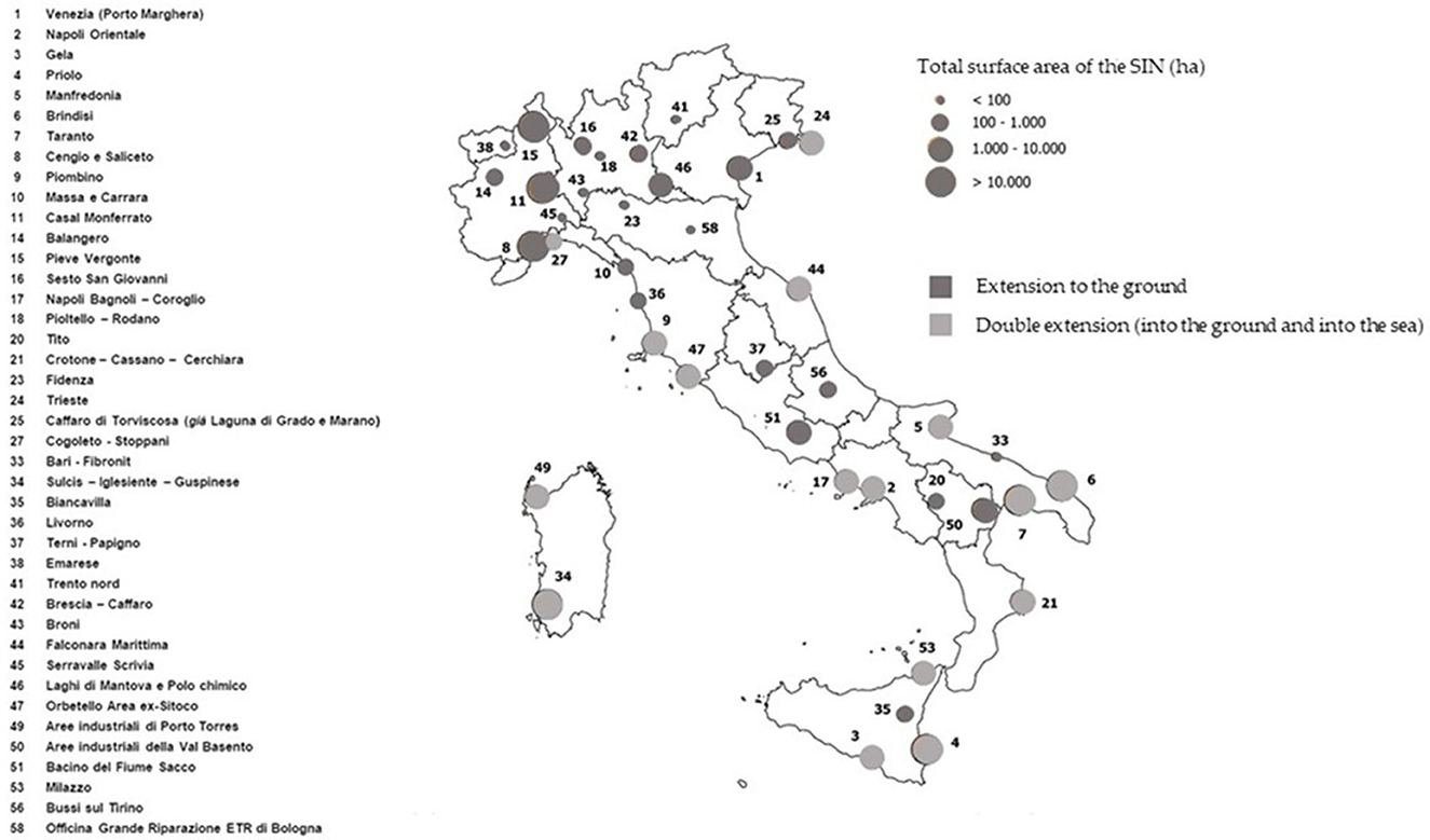
Figure 1. Localization of the SIN within the Italian context. Source: Istituto Superiore per la Protezione e la Ricerca Ambientale (ISPRA) – Authors re-elaboration.
According to the aim of the research related to the verification of the existence and, possibly, the extent of the influence that the presence of the 41 SIN determines on the real estate market dynamics, a set of independent variables capable of enucleating the main peculiarities of the SIN is identified. These are technological factors and locational ones and aim to provide a summary of the fundamental intrinsic characteristics of each site with respect to its status quo and location in the geographical context of reference (Angelakoglou et al., 2019; Gibilaro and Mattarocci, 2019). Furthermore, a range of factors which consider the potential influence of the proximity to the polluting site on human health is identified and collected (called health variables). This variables' category is taken as a proxy variable of the health phenomena determined by its closeness and aims to evaluate the perception of the danger of the site by the community in terms of health risks which is reflected in the choices of buyers and sellers (Haninger et al., 2012; Heitz et al., 2019).
Due to the primary frequencies of the indicators' existence in the relevant literature, it was determined to concentrate on the types of indicators mentioned above. In addition, selection was done using uniform individualization criteria that did not anticipate specific, localized circumstances of reference. The relationship between market pricing and environmental quality characteristics has been the subject of several contributions; nevertheless, any parameters of this type should be based on an investigation of each pollution site under review.
Below are the three categories of variables selected for the study:
• Total surface area of the site, expressed in hectares and evaluated as the sum of the extension of the SIN at sea and on land (S);
• Industrial plant opening date, calculated as the difference between the current year (2023) and the construction one (Y);
• State of the site (if it is still operational, decommissioned or partially functional), considered as a ordinal variable (the score 1 is assigned to the decommissioned SIN condition, the score 0 to the active state and the score 0.5 to the partial functionality, or when some activities within the SIN have been discontinued) (D).
• Distance of the SIN from the nearest public green space, calculated in km on foot (V);
• Distance of the SIN from the urban center, calculated in km on foot from the first agglomeration of buildings present (C);
• Accessibility level, assessed in terms of distance from the nearest entrance to the high-speed road, calculated in km by car (A).
• Mortality rate from cancer (T);
• Mortality rate from diseases of the nervous system (N).
These variables are determined on the basis of the average value, estimated on a ten-year historical basis (2010–2020) for each study province in which the analyzed SIN fall, referring to the data reported by the database of Health For All of the National Institute of Statistics (ISTAT). The Table 1 summarizes the mean, the min and the max values, the unit of measurement and the type of variable (ordinal/cardinal) of the considered factors.
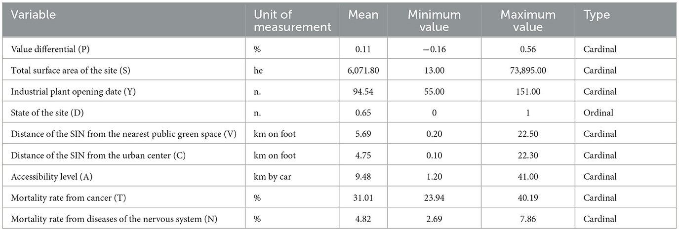
Table 1. Main descriptive statistics of the considered variables.
The dependent variable considered in the analysis is represented by the value differential between the average price recorded at municipal level and the average price of the micro-zone in which the SIN falls, both expressed in €/m2 for the residential market segment and referring to the year 2023. The choice to use the differential of average housing sales prices is linked to the objective of the work of analyzing the influence of the presence of the SIN on the dynamics of the real estate market and, in particular, on the difference existing between the average real estate values in the reference context and those of the specific urban area in which the SIN is located. The assumption underlying the logical evaluation model is, in fact, that the gap detected is associated with the presence of the contaminated site and its specific characteristics and that the value differential is an adequate proxy variable of the preferences of potential buyers.
The econometric technique implemented in the present research for the verification of the existence and extension of the correlations between the presence of the SIN and the differential between the municipal average residential prices and the average property selling prices observed in the urban area in which the SIN is included, borrows the operative logic of Hedonic Prices (HP) methods. The technique is called Evolutionary Polynomial Regression (EPR) and is explained in depth in different research papers concerning several fields, among which the real estate one (Tajani et al., 2017; Di Liddo et al., 2020; Morano et al., 2020). In particular, the econometric technique is used in this research for the analysis of the contribution of the different variables on selling prices (i) by identifying the most influencing factors, (ii) by determining the function correlation typology (direct or inverse). The tool is functional to the quantification of the percentage contribution of each factor (independent variable) on property prices differential (dependent variable). Different applications have already attested the potentialities of the EPR technique if compared to HP, Artificial Neural Networks (ANN) and Utility Additive (UTA) approaches (Morano et al., 2018). It should be highlighted that the main advantages of the EPR technique are related to the possibility to obtain the Pareto optimal frontier by considering the following three conflictual objectives: the maximization of the statistical accuracy; the minimization of the complexity of the model and the maximization of the model's parsimony. The implementation of EPR also allows to generate non-linear marginal function of the variables included in the model - the marginal price is not constant - and this demonstrates a higher empirical validity of the mathematical correlations that reflect in a better way the real market behavior. In addition, with reference to the possibility to immediately identify the functional correlation between the explanatory variables and the dependent one, the Artificial Neural Networks is not able to do it, the HP models have minor statistical goodness, whereas EPR automatically selects the optimal functions that are easily interpretable. The UTA approach, instead, even if consents the identification of marginal utility functions divided into sections, is more computationally complex due to the lack of software for the automatic and encoded implementation of the UTA algorithms (Tajani et al., 2016).
After the implementation of the EPR technique to the case study a set of models has been obtained. Each model is expressed in polynomial form in which the dependent variable is the differential in average housing sales prices recorded at municipal level and in the micro-zone to which the SIN belongs (P) and the independent ones are selected by EPR among the factors listed in the sub-paragraph 1 (initially considered). Each additive term of the mathematical expression of the models is assumed as a combination of the input variables raised to the proper numerical exponents. In particular, the candidate exponents selected in the research belong to the set (0; 0.5; 1; 2) and the maximum number of additive terms in final expressions is assumed equal to eight. The several models differ in terms of the statistical performance level (summarized by the Coefficient of Determination) and the complexity of the algebraic expression (in terms of the quantity of the equation terms and the number of variables combined in each term): in this sense, the first choice of the “best” model (i.e., that to be analyzed in accordance with the aim of the paper) should be carried out taking into account these two aspects and, then, the empirical consistence of the coefficient's signs. Among the models generated by EPR, in this analysis the one chosen for the subsequent analysis related to the quantification of the contribution of each selected influencing factor on the price's differential is reported below (Equation 1):
By taking into account the collected input data, among the 8 variables initially selected for the study, seven factors have been included in the model generated by EPR as considered influencing in the residential market dynamics. The only variable initially considered in the analysis but not included in the model generated by EPR and selected by the user is that relating to the accessibility level, assessed in terms of distance from the nearest entrance to the fast road artery. The exclusion of this factor from those most influential in the formation processes of real estate prices attests to a lack of market appreciation for the proximity to a specific urban or extra-urban road.
The analysis of the functional correlations between the selected independent variables and the value differential between the average price recorded at municipal level and the average price of the micro-zone in which the SIN falls (Figure 2) has allowed to (i) verify the empirical consistence with the expected outputs and (ii) determine the weight of each explanatory variables on the preferences of potential buyers.
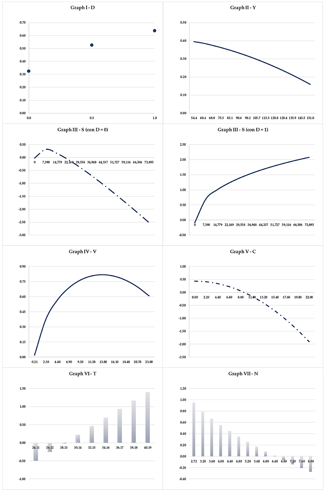
Figure 2. Functional relationships between the locational, technological, and health variables chosen by the econometric approach and the considered value differentials.
For each of the seven factors selected by EPR technique as the most influencing in the real estate mechanisms, a brief explanation is provided below, according to the following three category categories of variables: technological, locational and health.
With reference to the technological variables, the total surface area of the SIN (S) represents a relevant factor considered in the choice processes related to the housing market (Gibilaro and Mattarocci, 2019). When the SIN is abandoned (D = 1) a direct link with the extension of the site and the value differential between the prices recorded for the entire municipality and those of the micro-zone to which the site belongs is observed. As the size of the polluted area grows, the gap between prices progressively increases, with the municipal average always higher than that of the micro-zone. The phenomenon described demonstrates how the size of the SIN influences the decision-making processes of potential subjects interested in purchasing a house to satisfy their own needs (and therefore for personal use) or for investment purposes (Zhao et al., 2018). In correspondence with SIN of limited dimensions (in the study sample analyzed the smallest SIN has a total extension of 13 hectares), a negative differential between the average municipal quotation and the micro-zone quotation is detected, i.e., a negative value is established higher average real estate prices in the micro-zone to which the SIN belongs compared to the average recorded in the broader context of the municipality. For SIN with a size of 85 hectares, a substantial coincidence of real estate prices is observed and, therefore, a value differential equal to 0%, which is associated with an almost zero influence of the presence of the SIN on the dynamics of the residential market of reference.
When the SIN is active (D = 0), the trend of the dependent variable observed on the basis of the collected study sample is opposite to that described for decommissioned SIN and, therefore, of an inverse type. Specifically, there is an initial increase in the value gap between average municipal quotations and micro-zone quotations which, starting from positive values (municipal quotation higher than the micro-zone quotation) and in correspondence with SIN of limited size (beyond below 8,000 hectares), is followed by a gradual decrease in the differential. For SIN with a total extension of ~20,000 hectares, equality is verified between the prices recorded at municipal level and those of the reference micro-zone (value differential equal to 0%). Once this threshold is exceeded, there is a reversal of the trend in the value differential with the prices of the micro-zone taking on higher values than those of the municipal ones (negative differentials). Therefore, while maintaining the decreasing trend already noted, the increase in the gap between the municipal and micro-zone quotations referring to each SIN of the study sample is highlighted with a growing appreciation for the urban areas in which the active sites occupy surfaces greater. The result obtained is consistent with the expected one, given the job opportunities that larger active SINs offer compared to smaller ones. In the illustrated scenario (in which the SIN is functioning), the ability of the SIN to attract new potential workers, configuring itself as a receptacle of work and, therefore, a source of wealth, constitutes a significantly influential factor in purchasing choices, distorting the vision of the SIN as a polluted and polluting place, dangerous for human health.
For the technological variable relating to the age of the SIN (Y), the observed trend of the value differential between the average price recorded at municipal level and the average price of the micro-zone in which the SIN falls is of an inverse type both for decommissioned and active SIN. As the difference between the current year 2023 and the year of construction of the SIN increases (i.e., the older the SIN is), a decrease in the differential between the municipal price and that of the micro-zone is found. As the date of creation of the SIN increases, the differential between the municipal and micro-zone quotations diminishes, mainly thanks to different factors that characterize the area in which these SINs are located which, being older, is more urbanized (Warren et al., 2017). In fact, it must be highlighted that, especially in the periods of maximum industrial development, a real urban nucleus was established around the production plants, with private and public services, capable of creating a strong connection between working life and domestic life. In this sense, the oldest industrial plants are located in totally urbanized areas in which the presence of facilities (potentially also easily accessible and well-functioning) constitutes a determining factor in the decisions to purchase properties for residential use.
The status of the SIN in relation to its degree of operation is among the factors included in the model generated by EPR as influential in the dynamics of the real estate market.
The graph in Figure 2 shows that in all three situations (D = 0, D = 0.5, and D = 1), the value differential between the municipal prices and those of the SIN micro-zone is positive, ensuring an average value of prices housing in the larger municipality compared to that of the micro-zone. Furthermore, the trend found with reference to the study sample is increasing (on average by 28% moving from a condition of total inactivity to that of partial functionality and, subsequently, to that of total operation and by 49% in the transition from the situation of complete inactivity to that of full activity) but not constant. In fact, there is an increase of 38% in correspondence with the transition from an active SIN to a partially active one and of 17% when moving from this condition to that in which the SIN is completely decommissioned. In the situation where the SIN is active, this constitutes a potential workplace for the community. Proximity to the job site represents a significant element appreciated by buyers who, ordinarily, show a preference for houses located not too far from the workplace. The result obtained for variable D attests to a significant importance assumed by the economic component strictly associated with the presence of a SIN in full operation, which is reflected in a value differential between the observed prices that is less considerable compared to the condition in which the SIN is decommissioned (Nguyen and Nguyen, 2021).
In fact, if the SIN is decommissioned, the community's general sharing of the presence of the polluting site (a source of risk for human health) and, very often, in a state of abandonment and degradation, determines an increase in the difference in quotations with the average value of prices at municipal level higher than those of the micro-zone to which the SIN belongs.
The considerations made on variable D are in line with the generally valid behavior assumed by communities residing near production plants, which have been the subject of extensive public debate for years due to the health impacts that proximity to such plants causes.
With regards to the locational variables, the distance of the SIN from the nearest public green space (V) and the distance of the SIN from the urban center (C) are the two variables included in the model obtained from the implementation of the econometric technique and selected for the analysis among the three initially considered (Yao and Stewart Fotheringham, 2016; Soltani et al., 2022).
The functional correlations found for the variable V in the situation of active SIN and in that of decommissioned SIN are consistent with what was expected. As the distance of the SIN from the nearest green area increases, the trend detected in the two situations is parabolic. For the active SIN, starting from the situation observed for the study sample of minimum proximity to the public green space (distance equal to 0.20 km) for which the differential is negative (average price of the micro-zone higher than the municipal one), it stands then a progressive growth of the positive differential between municipal and micro-zone prices. The gradual increase in the gap in real estate values shows its peak at a distance from the nearest green area equal to 13.80 km, beyond which it transforms into the opposite and inverse trend. In this scenario with the site functioning, the proximity of the SIN to the nearest urban green area has a significant influence, constituting a factor positively appreciated in real estate choices. The same trend of the variable V with D = 1 (i.e., decommissioned SIN) differs in correspondence with the condition of V = 0.20 Km for which the recorded difference is almost equal to 0, with the average price of the micro-zone in which the SIN is located similar to the municipal one.
The maximum positive differential (with the municipal quotation higher than that of the micro-zone) is found at the distance from the green area closest to the SIN equal to 16.0 km, beyond which the progressive reduction of the differential is highlighted (corresponding to the second part of the decreasing parabolic trend). The output obtained in the two situations analyzed (D = 0 and D = 1) indicates how the operation of the site takes on a central role in the residential dynamics which are reflected (i) in the preferences shown by potential buyers, and (ii) in the formation of sales prices.
With reference to the location variable C (distance of the SIN from the nearest urban center), as the value of this factor increases, the differential between the average municipal price and that of the micro-zone in which the site is located decreases (Ho et al., 2021). Starting from positive differentials which demonstrate average real estate values recorded at a municipal level that are higher than those of the micro-zone to which the SIN belongs, corresponding to a distance from the production plant to the urban center of ~9.0 km, we observe a differential equal to 0 and therefore substantial uniformity in the market values of residential properties. Once this distance has been overcome, even with the same inverse trend between the distance of the SIN from the urban center and the differential of the real estate prices, negative differentials progressively increase in absolute value are highlighted (the average price of the micro-zone of the SIN is gradually greater than the average municipal price). At SIN further away from the urban center, the price of the micro-zone is therefore higher than that of the municipal one, due to the infrastructural systems and public and private services built around the site which make the neighboring area attractive from a real estate point of view. In this sense, the urban development of the SIN area furthest from already structured urban centers has become necessary over the years, creating real “satellite cities,” in which the SIN constitutes the polarity around which the built spaces diversified in terms of functions and relationships, of various sizes, equipped with primary and secondary urbanization works and the different infrastructures and commercial activities were created. In general terms, the urban context defined starting from the SIN is progressively enriched with services for the community, allowing SIN workers not to travel long distances to reach the workplace.
It must first of all be underlined that both variables initially considered in the analysis are included in the model generated by the econometric technique among the most influential factors in the real estate mechanisms connected to the presence of SIN. For the variable relating to the cancer mortality rate (T) recorded at the provincial level with respect to the location of the SIN analyzed, the constructed trend is fully in line with what was expected. For active SIN, as the mortality rate from cancer increases, the trend in the differential between the municipal price and that of the micro-zone increases. At a rate of up to ~28, the price of the micro-zone in which the SIN falls is higher than that of the municipality, subsequently undergoing a gradual decrease which is reflected in an increase in the differential detected. Beyond this threshold, in fact, the municipal quota is higher than that of the micro-zone in a gradually increasing manner, attesting to a relationship of direct proportionality between the mortality rate from cancer and the differential in real estate values found (Heitz et al., 2019).
The trend obtained demonstrates that, in situations where the mortality rate is low, the danger to human health and the risk of death from tumors is not perceived as linked to the SIN and, therefore, an influencing factor on residential prices (Haninger et al., 2012).
For decommissioned SINs, the trend is like that described, even if the trend reversal of the differential between the municipal price and the micro-zone price is observed for a smaller mortality rate from tumors (26 compared to 28 in the situation of active SINs). This discrepancy can be reasonably justified by considering the state of the SIN, i.e., its functionality or inactivity. In fact, the condition of full productivity of the SIN translates into the general sharing of the site as a place of work, a source of income, which determines the overcoming of the fear felt for the health associated with the industrial site. This leads to real estate prices in the micro-zone being higher than those in the municipal ones, corresponding to higher cancer mortality rates than what was found for abandoned SIN. By assuming that the residential selling prices are a proxy variable of the preferences shown by potential buyers regarding the presence, the result has allowed to attest the relevance of the state of the site (functioning or decommissioned) with respect to other (health) issues and social).
The findings obtained for the second variable health are contrary to those expected. In fact, the direct functional relationship between the mortality rate for diseases of the nervous system (N) and the differential between the municipal prices and those of the micro-zone in which the SIN falls which was empirically expected, does not correspond to the outputs achieved. As the mortality rate due to diseases of the nervous system increases, there is a progressively decreasing differential in real estate values. In this way, the average municipal price gradually approaches that of the micro-zone, decreasing and attenuating the difference in value between the two. The correspondence of the average prices (differential equal to 0) is found for a mortality rate equal to 6.40. From this value, the trend of the differential is the opposite, with the average price of the micro-zone in which the SIN falls greater than that of the municipal one. The result found attests to the absence of the link between mortality connected to neurological pathologies and the presence of the SIN: the possibility of contracting diseases of the nervous system is not, therefore, associated with the proximity of the home to the SIN. The increase in real estate values in the micro-zone to which the SIN belongs is possibly correlated to other specific factors that make the urban area more attractive from a real estate point of view (Gunn et al., 2022).
The industrial sector is one of the most relevant items in the ranking of importance for the global Gross Domestic Product (GDP), which can be identified as an ever-present element in a country's sustainable development policies and strategies. However, many existing brownfield sites are former industrial, agricultural, military, transport, religious or community businesses that have lost their economic use but remain an integral part of urban and rural spaces and should therefore be considered appropriately in development planning. Furthermore, the real estate market reflects the influence of the presence of industrial sites in a manner commensurate with their respective importance, the creation of jobs, the activities carried out and, above all, the services and infrastructures created in the surrounding area. For these reasons, the analysis of the influence of the presence of industrial sites that are active, abandoned, polluting and partially active constitutes a topic of international interest, both in the academic literature of reference and in public debates and global development policies. In particular, the presence of industrial sites can influence the dynamics of the local real estate market, to the point of significantly changing supply and demand.
The research is part of the outlined context. The aim was to verify the existence, the extent and the typology of the functional relationships between the presence of industrial polluting sites and a set of 8 technological, locational and health variables detected for 41 SINs in the Italian context. The application of the econometric technique through the EPR software has shown interesting results. First of all, in the analyzed case study the accessibility degree has appeared to be not a considered factors in the demand and supply mechanisms of the reference real estate markets, due to the general good level of urban and extra-urban roads that reach the industrial sites. For the technological aspects, the total surface area (S) of the SIN has been particularly appreciated. In fact, it has been observed that if the SIN is still active the trend of the dependent variable observed based on the collected study sample is opposite to that described for decommissioned SIN and, therefore, of an inverse type. Moreover, the oldest industrial plants are in totally urbanized areas in which the presence of facilities (potentially also easily accessible and well-functioning) constitutes a determining factor in the decisions to purchase properties for residential use. In fact, the activity level of the SIN attested a significant importance assumed by the economic component strictly associated with it. With regards to the locational variables, the nearest green spaces (V) and the city center (C) have highlighted that if an active SIN is near a green space, the latter prevails on the buyers' preferences, and that beyond a certain distance from the city center this feature is no more appreciated. The obtained results for the health variables demonstrated that the possibility of contracting diseases of the nervous system is not, therefore, associated with the proximity of the house to the SIN. The trend obtained for the other one variable demonstrates that, in situations where the mortality rate is low, the danger to human health and the risk of death from tumors is not perceived as linked to the SIN and, therefore, an influencing factor on residential prices.
The proposed logical-valuative model is characterized by high statistical accuracy and robustness, allowing to identify coherent functional relationships between the considered set of extrinsic variables and the real estate dynamics. It can be easily applied to other international context of different territorial scale for mapping the influence of the presence of industrial polluting sites in several further property market segments, such as offices, retail, etc. The limits of the research concern the lack of consideration of other market segments, such as offices, that could be influenced by polluting sites, the use of a small set of explanatory variables and a limited sample of properties.
Further insights of the research will concern the application of the proposed methodology to international industrial contexts and the identification of a novel set of variables that can also be related to the air pollution and air quality levels of urban and rural areas, due to their importance as highlighted by Mei et al. (2020), Tsai (2022), and Chiarazzo et al. (2022) for the significance between the pollution levels and the real estate market. Furthermore, the comparison of the results obtainable from the implementation of other econometric techniques (e.g., ANN, UTA, HP models) with those of the EPR can be useful for testing the validity of the methodology and its potential and/or critical issues.
The original contributions presented in the study are included in the article/supplementary material, further inquiries can be directed to the corresponding author.
FT: Writing—original draft, Writing—review & editing. PM: Writing—original draft, Writing—review & editing. FDL: Writing—original draft, Writing—review & editing. DA: Writing—original draft, Writing—review & editing. FS: Writing—original draft, Writing—review & editing.
The author(s) declare that financial support was received for the research, authorship, and/or publication of this article. This contribution is to be framed within the PRIN 2022 project – INSPIRE: Improving Nature – Smart Policies through Innovative Resilient Evaluations.
The authors declare that the research was conducted in the absence of any commercial or financial relationships that could be construed as a potential conflict of interest.
All claims expressed in this article are solely those of the authors and do not necessarily represent those of their affiliated organizations, or those of the publisher, the editors and the reviewers. Any product that may be evaluated in this article, or claim that may be made by its manufacturer, is not guaranteed or endorsed by the publisher.
Accordino, J., and Johnson, G. T. (2000). Addressing the vacant and abandoned property problem. J. Urb. Affairs 22, 301–315. doi: 10.1111/0735-2166.00058
Alker, S., Joy, V., Roberts, P., and Smith, N. (2000). The definition of brownfield. J. Environ. Plann. Manage. 43, 49–69. doi: 10.1080/09640560010766
Anelli, D., and Tajani, F. (2022). Valorization of cultural heritage and land take reduction: an urban compensation model for the replacement of unsuitable buildings in an Italian UNESCO site. J. Cult. Herit. 57, 165–172. doi: 10.1016/j.culher.2022.08.006
Anelli, D., and Tajani, F. (2023). Spatial decision support systems for effective ex-ante risk evaluation: an innovative model for improving the real estate redevelopment processes. Land Use Policy 128, 106595. doi: 10.1016/j.landusepol.2023.106595
Angelakoglou, K., Nikolopoulos, N., Giourka, P., Svensson, I. L., Tsarchopoulos, P., Tryferidis, A., et al. (2019). A methodological framework for the selection of key performance indicators to assess smart city solutions. Smart Cities. 2, 269–306. doi: 10.3390/smartcities2020018
Atkinson, G., Doick, K. J., Burningham, K., and France, C. (2014). Brownfield regeneration to greenspace: Delivery of project objectives for social and environmental gain. Urb. Forestr. Urb. Greening 13, 586–594. doi: 10.1016/j.ufug.2013.04.002
Bacot, H., and O'Dell, C. (2006). Establishing indicators to evaluate brownfield redevelopment. Econ. Dev. Q. 20, 142–161. doi: 10.1177/0891242405285749
Banzhaf, H. S., and McCormick, E. (2006). Moving Beyond Cleanup: Identifying the Crucibles of Environmental Gentrification; Report Prepared for the National Center for Environmental Economics. Washington, DC: EPA.
Baxter, V., and Lauria, M. (2000). Residential mortgage foreclosure and neighborhood change. Hous. Policy Deb. 11, 675–699. doi: 10.1080/10511482.2000.9521382
Bleicher, A., and Gross, M. (2010). Sustainability assessment and the revitalization of contaminated sites: operationalizing sustainable development for local problems. Int. J. Sust. Dev. World Ecol. 17, 57–66. doi: 10.1080/13504500903488263
Braden, J. B., Feng, X., and Won, D. (2011). Waste sites and property values: a meta-analysis. Environ. Res. Econ. 50, 175–201. doi: 10.1007/s10640-011-9467-9
Chiarazzo, V., dell'Olio, L., Ibeas, A., and Ottomanelli, M. (2022). Modeling the effects of environmental impacts and accessibility on real estate prices in industrial cities. Proc. Soc. Behav. Sci. 111, 460–469. doi: 10.1016/j.sbspro.2014.01.079
Dasgupta, S., and Tam, E. K. L. (2009). Environmental review: a comprehensive review of existing classification systems of brownfield sites. Environ. Prac. 11, 285–300. doi: 10.1017/S1466046609990287
De Sousa, C. A. (2002). Measuring the public costs and benefits of brownfield versus greenfield development in the Greater Toronto area. Enviro. Plann. Design 29, 251–280. doi: 10.1068/b1283
De Sousa, C. A. (2006). Unearthing the benefits of brownfield to green space projects: an examination of project use and quality of life impacts. Local Environ. 11, 577–600. doi: 10.1080/13549830600853510
Di Liddo, D., Morano, F., Tajani, P. F., and Torre, C. M. (2020). An innovative methodological approach for the analysis of the effects of urban interventions on property prices. Valori E Valutazioni 26, 2604. doi: 10.48264/VVSIEV-20202604
Dixon, T. (2006). Integrating sustainability into brownfield regeneration: Rhetoric or reality?–An analysis of the UK development industry. J. Prop. Res. 23, 237–267. doi: 10.1080/09599910600933889
Dubé, J., Desaulniers, S., Bédard, L. P., Binette, A., and Leblanc, E. (2018). Urban residential reconversion through demolition: a land use model based on administrative spatial micro-data. Land Use Policy 76, 686–696. doi: 10.1016/j.landusepol.2018.02.052
European Commission (2014). Cohesion Policy Legislation 2014–2020. Available online at: https://ec.europa.eu/ (accessed September 8, 2022).
European Commission (2015). European Structural and Investment Funds 2014-2020: Official Texts and Commentaries. Available online at: https://ec.europa.eu (accessed September 8, 2022).
European Commission (2019). Green Deal. Available online at: https://ec.europa.eu/info/strategy/priorities-2019-2024/european-greendeal_it (accessed March 28, 2022).
European Commission (2021). New Cohesion Policy. Available online at: https://ec.europa.eu/ last (accessed September 9, 2023).
European Council Directive 91/271/EEC (1991). Official Journal of the European Communities. Available online at: https://eur-lex.europa.eu/legal-content/EN/TXT/PDF/?uri=CELEX:31991L0271 (accessed May 21, 1991).
European Environmental Agency Costs of Air Pollution From European Industrial Facilities 2008–2017 (2020). Available online at: https://www.eionet.europa.eu/etcs/etc-atni/products/etc-atni-reports/etc-atni-report-04-2020-costs-of-air-pollution-from-european-industrial-facilities-200820132017 (accessed April 14, 2020).
European Parliament and Council Directive 2000/60/EC (2000). Official Journal of the European Union. Available online at: https://eur-lex.europa.eu/resource.html?uri=cellar:5c835afb-2ec6-4577-bdf8-756d3d694eeb.0004.02/DOC_1&format=PDF (accessed October 23, 2000).
European Parliament andCouncil Directive 2003/87/EC (2003). Official Journal of the European Union. Available online at: https://eur-lex.europa.eu/legal-content/EN/TXT/PDF/?uri=CELEX:32003L0087 (accessed October 13, 2003).
European Parliament and Council Directive 2009/125/EC (2009). Official Journal of the European Union. Available online at: https://eur-lex.europa.eu/LexUriServ/LexUriServ.do?uri=OJ:L:2009:285:0010:0035:en:PDF (accessed October 21, 2009).
European Parliament and Council Directive 2010/75/EU (2010). Official Journal of the European Union. Available online at: https://eur-lex.europa.eu/legal-content/EN/TXT/PDF/?uri=CELEX:32010L0075 (accessed November 24, 2010).
European Parliament and Council Directive 2015/2193/EU (2015). Official Journal of the European Union. Available online at: https://eur-lex.europa.eu/legal-content/EN/TXT/PDF/?uri=CELEX:32015L2193 (accessed November 25, 2015).
Gamper-Rabindran, S., and Timmins, C. (2013). Does cleanup of hazardous waste sites raise housing values? Evidence of spatially localized benefits. J. Environ. Econ. Manage. 65, 345–360. doi: 10.1016/j.jeem.2012.12.001
Gibilaro, L., and Mattarocci, G. (2019). Brownfield areas and housing value: evidence from Milan. J. Sust. Real Estate. 11, 60–83. doi: 10.22300/1949-8276.11.1.60
Green, T. L. (2018). Evaluating predictors for brownfield redevelopment. Land Use Policy 73, 299–319. doi: 10.1016/j.landusepol.2018.01.008
Gunn, L. D., Saghapour, T., Giles-Corti, B., and Turrell, G. (2022). Exploring inequities in housing affordability through an analysis of walkability and house prices by neighborhood socioeconomic disadvantage. Cities Health 6, 616–634. doi: 10.1080/23748834.2022.2072058
Haninger, K., Ma, L., and Timmins, C. (2012). Estimating the impacts of brownfield remediation on housing property values. Duke Environ. Energ. Econ. Working Paper Series 12, 2469241. doi: 10.2139/ssrn.2469241
Haninger, K., Ma, L., and Timmins, C. (2017). The value of brownfield remediation. J. Assoc. Environ. Res. Econ. 4, 197–241. doi: 10.1086/689743
Heberle, L., and Wernstedt, K. (2006). Understanding brownfields regeneration in the US. Local Environ. 11, 479–497. doi: 10.1080/13549830600853064
Heitz, A., Launay, P., and Beziat, A. (2019). Heterogeneity of logistics facilities: an issue for a better understanding and planning of the location of logistics facilities. Eur. Transp. Res. Rev. 11, 5. doi: 10.1186/s12544-018-0341-5
Ho, W. K., Tang, B. S., and Wong, S. W. (2021). Predicting property prices with machine learning algorithms. J. Prop Res. 38, 48–70. doi: 10.1080/09599916.2020.1832558
Hula, R. C., and Bromley-Trujillo, R. (2010). Cleaning up the mess: redevelopment of urban brownfields. Econ. Dev. Q. 24, 276–287. doi: 10.1177/0891242410365711
Immergluck, D. (2008). From the subprime to the exotic: excessive mortgage market risk and foreclosures. J. Am. Plann. Assoc. 74, 59–76. doi: 10.1080/01944360701702313
Kaufman, D. A., and Cloutier, N. R. (2006). The impact of small brownfields and greenspaces on residential property values. The J. Real Estate Financ. Econ. 33, 19–30. doi: 10.1007/s11146-006-8272-7
Kuethe, T. H. (2012). Spatial fragmentation and the value of residential housing. Land Econ. 88, 16–27. doi: 10.3368/le.88.1.16
Lange, D. A., and McNeil, S. (2004). Brownfield development: tools for stewardship. J. Urb. Plan. Dev. 130, 109–116. doi: 10.1061/(ASCE)0733-9488(2004)130:2(109)
Leigh, N. G., and Coffin, S. L. (2005). Modeling the relationship among brownfields, property values, and community revitalization. Hous. Policy Deb. 16, 257–280. doi: 10.1080/10511482.2005.9521543
Longo, A., and Alberini, A. (2006). What are the effects of contamination risks on commercial and industrial properties? Evidence from Baltimore, Maryland. J. Environ. Plann. Manage. 49, 713–737. doi: 10.1080/09640560600850028
Martinat, S., Navratil, J., Picha, K., Tureckova, K., and Klusacek, P. (2017). Brownfield regeneration from the perspective of residents: place circumstances versus character of respondents. Deturope 9, 71–92. doi: 10.32725/det.2017.013
McCarthy, L. (2002). The brownfield dual land-use policy challenge: reducing barriers to private redevelopment while connecting reuse to broader community goals. Land Use Policy 19, 287–296. doi: 10.1016/S0264-8377(02)00023-6
Mei, Y., Gao, L., Zhang, J., and Wang, J. (2020). Valuing urban air quality: a hedonic price analysis in Beijing, China. Environ. Sci. Pollut. Res. 27, 1373–1385. doi: 10.1007/s11356-019-06874-5
Morano, P., Guarnaccia, C., Tajani, F., Di Liddo, D., and Anelli, F. (2020). An analysis of the noise pollution influence on the housing prices in the central area of the city of Bari. J. Phys. Conf. Series 1, 12027. doi: 10.1088/1742-6596/1603/1/012027
Morano, P., Tajani, F., Guarini, M. R., and Sica, F. (2021). A systematic review of the existing literature for the evaluation of sustainable urban projects. Sustainability 13, 4782. doi: 10.3390/su13094782
Morano, P., Tajani, F., and Locurcio, M. (2018). Multicriteria analysis and genetic algorithms for mass appraisals in the Italian property market. Int. J. Hous. Markets Anal. 11, 229–262. doi: 10.1108/IJHMA-04-2017-0034
Mueller, G. (2005). Brownfields Capital—Unlocking value in environmental redevelopment. J. Real Est. Portf. Manage. 11, 81–92. doi: 10.1080/10835547.2005.12089715
National Recovery and Resilience Plan (NRRP). (2022). Available online at: www.mef.gov.it (accessed January 7, 2022).
Navrátil, J., Krejčí, T., Martinát, S., Pícha, K., Klusáček, P., Škrabal, J., et al. (2020). Abandonment or regeneration and re-use? Factors affecting the usage of farm premises in different social spaces of the rural. Sustainability. 12, 9124. doi: 10.3390/su12219124
Next Generation EU. (2022). Recovery Fund. Available online at: www.ec.europa.eu.it (accessed January 5, 2022).
Nguyen, D., and Nguyen, T. H. T. (2021). The external impacts of historic landmarks and buildings on townhouse prices in Vietnam. Int. J. Hous. Markets Anal. 14, 1092–1110. doi: 10.1108/IJHMA-08-2020-0104
Pan, Q., Pan, H., Zhang, M., and Zhong, B. (2014). Effects of rail transit on residential property values: Comparison study on the rail transit lines in Houston, Texas, and Shanghai, China. Trans. Res. Record. 2453, 118–127. doi: 10.3141/2453-15
Pediaditi, K., Wehrmeyer, W., and Chenoweth, J. (2005). Monitoring the sustainability of brownfield redevelopment projects: the redevelopment assessment framework. Land Contam. Reclam. 13, 173–183. doi: 10.2462/09670513.665
Potschin, M., and Haines-Young, R. (2008). Sustainability impact assessments: limits, thresholds and the sustainability choice space. Sust. Imp. Assessm. Land Use Changes 425–450. doi: 10.1007/978-3-540-78648-1_21
Schädler, S., Morio, M., Bartke, S., Rohr-Zaenker, R., and Finkel, M. (2011). Designing sustainable and economically attractive brownfield revitalization options using an integrated assessment model. J. Environ. Manage. 92, 827–837. doi: 10.1016/j.jenvman.2010.10.026
Schulze-Bäing, A., and Wong, C. (2012). Brownfield residential development: what happens to the most deprived neighbourhoods in England?. Urban Studies 49, 2989–3008. doi: 10.1177/0042098012439108
Schwilch, G., Bachmann, F., Valente, S., Coelho, C., Moreira, J., Laouina, A., et al. (2012). A structured multi-stakeholder learning process for sustainable land management. J. Environ. Manage. 107, 52–63. doi: 10.1016/j.jenvman.2012.04.023
Skrabal, J. (2020). What can we learn from brownfield databases? Exploring specifics of the location of brownfields in the Czech Republic. Geograph. Tech. 15, 191–201. doi: 10.21163/GT_2020.152.18
Soltani, A., Heydari, M., Aghaei, F., and Pettit, C. J. (2022). Housing price prediction incorporating spatio-temporal dependency into machine learning algorithms. Cities 131, 103941. doi: 10.1016/j.cities.2022.103941
Tajani, F., Guarini, M. R., Sica, F., Ranieri, R., and Anelli, D. (2022). Multi-criteria analysis and sustainable accounting. defining indices of sustainability under Choquet's integral. Sustainability 14, 2782. doi: 10.3390/su14052782
Tajani, F., Morano, P., Locurcio, M., and Torre, C. M. (2016). Data-driven techniques for mass appraisals. Applications to the residential market of the city of Bari (Italy). Int. J. Bus. Int. Data Mining 11, 109–129. doi: 10.1504/IJBIDM.2016.081604
Tajani, F., Morano, P., Torre, C. M., and Di Liddo, F. (2017). An analysis of the influence of property tax on housing prices in the Apulia region (Italy). Buildings 7, 67. doi: 10.3390/buildings7030067
Tsai, I. C. (2022). Impact of proximity to thermal power plants on housing prices: capitalizing the hidden costs of air pollution. J. Clean. Prod. 367, 132982. doi: 10.1016/j.jclepro.2022.132982
Turečková, K., Nevima, J., Duda, D., and Tuleja, P. (2021). Latent structures of brownfield regeneration: A case study of regions of the Czech Republic. J. Clean. Prod. 311, 127478. doi: 10.1016/j.jclepro.2021.127478
Walter, C., and Stützel, H. (2009). A new method for assessing the sustainability of land-use systems (II): Evaluating impact indicators. Ecol. Econ. 68, 1288–1300. doi: 10.1016/j.ecolecon.2008.11.017
Warren, C. M., Elliott, P., and Staines, J. (2017). The impacts of historic districts on residential property land values in Australia. Int. J. Hous. Markets Anal. 10, 66–80. doi: 10.1108/IJHMA-02-2016-0015
Williams, K., and Dair, C. (2007). A framework for assessing the sustainability of brownfield developments. J. Environ. Plann. Manage. 50, 23–40. doi: 10.1080/09640560601048275
Yao, J., and Stewart Fotheringham, A. (2016). Local spatiotemporal modeling of house prices: a mixed model approach. The Prof. Geograph. 68, 189–201. doi: 10.1080/00330124.2015.1033671
Yount, K. R. (2003). What are brownfields? Finding a conceptual definition. Environ. Prac. 5, 25–33. doi: 10.1017/S1466046603030114
Keywords: sustainable city, polluting sites-recovery, real estate properties, industrial sites, econometric technique, environmental impact
Citation: Tajani F, Morano P, Di Liddo F, Anelli D and Sica F (2023) The presence of polluting sites in urban contexts: an analysis of the effects on the dynamics of the residential real estate market. Front. Sustain. Cities 5:1314967. doi: 10.3389/frsc.2023.1314967
Received: 10 October 2023; Accepted: 01 December 2023;
Published: 22 December 2023.
Edited by:
Md Maruf Mortula, American University of Sharjah, United Arab EmiratesReviewed by:
Gabriella Maselli, University of Salerno, ItalyCopyright © 2023 Tajani, Morano, Di Liddo, Anelli and Sica. This is an open-access article distributed under the terms of the Creative Commons Attribution License (CC BY). The use, distribution or reproduction in other forums is permitted, provided the original author(s) and the copyright owner(s) are credited and that the original publication in this journal is cited, in accordance with accepted academic practice. No use, distribution or reproduction is permitted which does not comply with these terms.
*Correspondence: Debora Anelli, ZGVib3JhLmFuZWxsaUBwb2xpYmEuaXQ=
Disclaimer: All claims expressed in this article are solely those of the authors and do not necessarily represent those of their affiliated organizations, or those of the publisher, the editors and the reviewers. Any product that may be evaluated in this article or claim that may be made by its manufacturer is not guaranteed or endorsed by the publisher.
Research integrity at Frontiers
Learn more about the work of our research integrity team to safeguard the quality of each article we publish.