 Nina Liu
 Yingying Chen
 Fei Su*
- Department of Urban and Rural Planning, Zhejiang Gongshang University, Hangzhou, China
Once the integrated urban-rural development enters a high-quality development stage, multiple dimensions would be reflected in population, space, economics, society, and environment, which will further advance sustainable development. An integrated urban and rural development have shown different features, rules, and models amid different social systems and in different development stages. Therefore, it's urgent to scientifically measure the integration level of rural and urban areas, revealing the spatial differences, characteristics, and internal mechanism. Targeting the 41 cities within the Yangtze River Delta, this paper evaluates the integrated urban-rural development in this area based on the global principal component analysis, explores its spatial agglomeration and evolution pattern by ESDA method, analyzes the principal factors that result in the spatial differences in integrated urban and rural development in the Yangtze River Delta and their interactive relations by the geographical detector, and discusses the regional differences between those influencing factors by the geographical weighted regression method. The results indicate that (1) the integrated development of the 41 cities is not balanced and there is a great difference between different cities. (2) The integrated development of this area has shown the apparent feature of geographical agglomeration, or in other words, the central cities have become the forces that drive the development of neighboring cities. (3) Since integrated urban-rural development is influenced by economic development, basic infrastructure, government support, and industrial structure, all regions should put forward suggestions for the formulation of policies accordingly based on realities.
1. Introduction
The urban area and the rural area are organic components of the regional system. They are interdependent, integrated, and complementary (Ji et al., 2019). The urban-rural relationship is complex and refers to the symbiotic relationship of interaction between urban and rural areas that affect each system. It is the most basic economic and social relationship in the development of human society, and it is also an important relation that must be dealt with in regional development (Potter and Unwin, 1995; Herberholz and Phuntsho, 2018). Marx divides the urban-rural relation into three stages, respectively, the antagonism between urban and rural areas, their accelerated separation and integration. Urban-rural integration is essentially the last stage in the evolution of urban-rural relations placing greater emphasis on shared development opportunities and equality between urban and rural areas, and recognizing the unique and intrinsic value of rural areas. Urban-rural integration originates from the vision of urban-rural development from the Utopian socialist theory and is regarded as a necessary path to achieve common prosperity Urban and rural integration refers to many aspects, such as urban and rural structure, public infrastructure, economic structure, and ecological environment. In the context of regional sustainable development, urban-rural integration provides an important perspective for understanding key regional development issues and formulating effective policies to address them (Davoudi, 2002). Once the integrated urban-rural development enters into a high-quality development stage, multiple dimensions should be reflected in population, space, economics, society, and environment (Tacoli, 2002; Liu, 2018; Long and Tu, 2018), which will further advance the complementary and coordinated development between urban and rural areas.
With the advance of global urbanization and industrialization, the rural recession has become a global phenomenon. The contrast between the decline of rural areas and the prosperity of urban areas has become more obvious (Hommes and Boelens, 2017; Bennett et al., 2018). Urban and rural areas are two different but coexisting systems (Ann et al., 2014). Only the coordinated development of the two systems can support and promote the development of each system (Liu and Li, 2017). Therefore, balancing urban and rural development and achieving sustainable urban-rural integration have become a common challenge for all countries (Ma et al., 2021), the International Council of Science (ICSU) merged the Future Earth, the International Council of Science Unions and the International Social Science mainly focuses on the coupling development of urban and rural areas. The UN puts forwards the 2030 Agenda for Sustainable Development, which clarifies the aims of building sustainable cities and pushing forward rural revitalization. All over the world are actively exploring an integrated approach to urban and rural areas considering their basic conditions (Murdoch, 2000; Salvati and Carlucci, 2011; Miszak and Monsutti, 2014). A mature stage of integrated urban-rural development is also an important signal of national modernization. In this transformation development process, it's important to achieve a complementary and interactive development of rural and urban areas, change the city-biased mentality and bridge the gap between urban and rural areas. China's urbanization development is highly compressed in terms of space and time, and complex in terms of content (Liu and Li, 2011) and it is of international significance to analyze China as a case. The integrated urban and rural areas of China lack systematic theories and guidance, therefore, it's urgent to measure the level of integrated urban and rural development, reveal the development order and build a profound layout of urban-rural development, which is of great value to solve the gap between urban and rural areas and promote sustainable development.
The Yangtze River Delta is one of the regions with the most developed economy with a high economic level in both urban and rural areas and is now advancing integrated urban-rural development, which will provide an important reference for the other areas in our country to achieve integrated development. However, as the construction region of the Yangtze River Delta is expanding, the development differences in this delta are more and more apparent and show spatial features and evolution models of different stages and under different levels of urbanization. Therefore, this paper takes 41 cities in the Yangtze River Delta as the targets and builds an index system for evaluating the level of integrated urban-rural development of 17 indicators from the perspectives of economy, population, society, space, ecology, and culture based on data in 2000, 2005, 2010, 2015, and 2020 and research on the spatial differences and influencing factors of integrated urban-rural development and puts forward more targeted development suggestions.
The remainder of this article is structured as follows: Section 2 provides a literature review; Section 3 describes the materials and methods; Section 4 analysis the results; and Section 5 includes our conclusions and recommendations.
2. Literature review
Urban-rural relations have been researched in terms of theoretical connotation (Howard, 1898; Preston, 1975; Isserman, 2005; Natsuda et al., 2012; Zhou and Bai, 2014a), measurement and evaluation, spatial analysis and influencing factors, and bountiful results have been achieved. Urban-rural integration means viewing industry and agriculture, urban and rural, citizens and farmers, not as isolated parts. As a process of reshaping and reconstructing urban and rural values (Chen and Long, 2019), it is manifested in the transformation of dual structure to unit structure, the narrowing of urban-rural income gap, the progress of urban-rural productivity, and the improvement of living standards of urban and rural residents. The integrated development of urban and rural areas refers to the functional optimization of the urban and rural regional system through the interaction and complementarity between urban and rural areas. The fundamental purpose of this strategy is to break down institutional barriers and strengthen the interaction between urban and rural areas in terms of resources, labor, technology, and other aspects, thus to achieve coordinated urban and rural development (Chen and Li, 2004; Luo and Li, 2005). The urban-rural interaction in different regions presents different characteristics.
Urban-rural interaction is manifested in the flow of material, capital, personnel, information, and technology resources between urban and rural areas. Broadly speaking, resources tend to flow and aggregate in places where production costs are low, and profits are high (Krugman, 1991; Fujita et al., 1999; Glaeser, 2008). The direct consequence of this concentration of resources is the change in the landscape, manifested in the expansion of urban and rural settlements and the reduction of arable land. However, the integrated development of urban and rural areas is not only to eliminate the boundary between urban and rural areas and realize rural urbanization, nor to assimilate the functions and landscapes of cities, nor is it to homogenize urban and rural development, but to achieve equal development of urban and rural areas. Urban-rural equivalence development refers to the promotion of the right to just and equitable development in the urban-rural geographical system (Liu et al., 2013). Integrated urban-rural development aims to remove obstacles to urban-rural development through institutional innovation. It is conducive to promoting the free flow and equal exchange of urban and rural factors. The final result of the integrated development of urban and rural areas is the establishment of a new type of urban-rural relationship in which industry and agriculture promote each other, urban and rural complementarity, urban and rural areas are fully integrated, and symbiosis and common prosperity.
Many scholars have proposed regional theories of simultaneous urban and rural behaviors within the same geographical area and put forward theories such as “urban and rural integration” basing on the gap between urban and rural areas and problems of the integrated urban-rural development (Fields, 2005), “dual structure theory of urban and rural areas” (Graeml and Graeml, 2004), “urban-orientation theory” (Lipton, 1984) and “joint development of urban and rural areas” (Epstein, 2001), all of which have formed a series of famous models and theories, such as “the desakota” model” (Mcgee, 1989), “regional network model” (Douglass, 1998a,b), “continuum between urban and rural areas” (Tacoli, 1998), “urban and rural equating” (Lynch, 2005) as well as “flow space” theory (Castells, 1989). Castle et al. (2011) proposed the framework of urban-rural spatial integration considering the inequality of per capita salary of urban and rural residents and then discussed the historical interdependence between urban and rural areas. Kūle (2014) analyzed the local diversity and particularity of urban and rural integration in Europe Latvia in terms of regional policy and practice models. All the above theoretical explorations show that urban-rural integration has a positive effect on urban and rural development (Chung, 2017).
The measurement of urban-rural integration development is the basis of transforming qualitative analysis into the quantitative research on urban-rural development (Zhou and Bai, 2014b), which essentially is the measurement and evaluation of urban-rural factor flow combination and urban-rural relationship. Quantitative evaluation of urban and rural integration starts with the multidimensional perspective, such as Yang (1997) evaluated the domestic urban-rural integration level from perspectives of economy, population, space, life, and ecological environment. Since then, many scholars have also attempted to conduct a quantitative analysis of urban and rural development issues to search for a more comprehensive and scientific evaluation index system. Tang et al. (2021) built a comprehensive evaluation index system from efficiency and equity, Ma et al. (2020) built an index system of urban and rural life quality from the economy, society, and environment to evaluate urban-rural differences and integration, Yang et al. (2021) and Wang et al. (2021) built an urban-rural integration index from the economy, society, and space. As the research is more and more mature, it is impossible to comprehensively explain integrated urban-rural development from only two or three dimensions. Therefore, scholars represented by Wu and Cui (2016) and Kai and Jiahao (2015) extend the connotation of urban-rural integration to five dimensions of population, space, economy, society, and ecology to further integrate urban-rural development.
Integrated urban-rural development also shows certain characteristics and rules in terms of space. The level, mechanism, and mode of urban-rural integration show significant spatial and temporal correlation and heterogeneity (Wang et al., 2016). At present, the analysis methods of the spatial pattern of urban-rural integration mainly include spatial autocorrelation analysis (Wu and Cui, 2016), Markov chain model (Liu et al., 2013), hot spot analysis (Zhou et al., 2020) and cluster analysis (Xie et al., 2020). For example, Yang et al. (2021) adopted methods such as hot spot analysis, potential profile analysis to study the level and spatial differentiation of integrated urban-rural development in China and found that the significant spatial agglomeration feature of integrated urban-rural development in China is “high in the eastern region, low in the western and central region.” Guo and Xu (2013) used methods such as exploratory spatial data analysis (ESDA) and the Markov chain model to measure the development level of urban-rural integration in Jiangsu Province and found that the development level of urban-rural integration showed a downward trend from south to north. Xie et al. (2020) conducted ESDA on the urban-rural integration development of the Yangtze River Delta by using the statistical yearbook data of two cross-sections in 2007 and 2016 and revealed that the obvious agglomeration characteristics of urban integration development of the Yangtze River Delta. Zhang et al. (2020) comprehensively applied the LISA time path, the LSIA space-time transition and other methods to study the spatio-temporal dynamic characteristics of the development level of urban-rural integration in Huaihai Economic Zone with the help of the ESDA, which has enriched the research paradigm of urban-rural integration evolution from a spatio-temporal perspective. Taking Jiangsu province as an empirical area, Ma et al. (2006) proposed three fundamental regional differences of urban-rural spatial gradient, circle layer, and axis. In terms of influencing factors, scholars have shifted from single influencing factor analysis to multi-factor analysis. For example, Guo and Xu (2013) believe that economic strength, economic structure, and information technology application are the three major factors affecting the spatio-temporal evolution of the development level of urban-rural integration in Jiangsu Province. Yang et al. (2020) held the opinion that the urban-rural spatial difference in the Pearl River Delta is the result of the joint action of the regional growth force, market driving force, and government regulation force.
To sum up, the existing literatures can be great references, however, there are still some shortcomings: Scholars have adopted different research methods and constructed index systems of urban-rural integration development based on different perspectives to measure and analyze influencing factors in different regions. However, the research on the urban-rural integration development in the Yangtze River Delta region is still not comprehensive because of inadequate indicators, such as indicators of research dimensions or corresponding dimensions. Therefore, it is impossible to evaluate the development of urban-rural integration of cities objectively and comprehensively in the Yangtze River Delta. Moreover, the four provinces of Jiangsu, Zhejiang, Anhui, and Shanghai are designated as the planning area of the Yangtze River delta in 2019. Thus, all previous studies can't explain the existing spatial difference between urban and rural integration development in this delta, and the study of the development of urban and rural integration of Yangtze River Delta is of great significance.
From the domestic and foreign studies of urban and rural development, the existing research has disclosed the basic thinking, theoretical hypothesis, practicing paradigm, and measurement of urban and rural integration. However, the integrated urban and rural development have shown different features, rules, and models amid different social systems and in different development stages. Therefore, it's urgent to scientifically measure the integration level of rural and urban areas, reveal the spatial differences, characteristics, and internal mechanism.
Based on the literature review, this paper builds an evaluation index system of urban-rural integration development in terms of “economic integration,” “population integration,” “social integration,” “spatial integration,” “ecological integration,” and “cultural integration.” First, this paper applied the global principal component analysis to measure the integration level of the 41 cities in this delta from 2000 to 2020 and got corresponding results. Next, this paper adopts the ESDA method to analyze the spatial distribution of the integrated development of the Yangtze River Delta, explores the influencing factors of spatial differences by geographical detector and geographical weighted regression model and puts forward countermeasures and suggestion accordingly.
3. Materials and methods
3.1. Research object
With a total planned area of 358,000 square kilometers, the Yangtze River Delta covers Shanghai, 13 prefecture-level cities in Jiangsu Province, 11 prefecture-level cities in Zhejiang Province, and 16 prefecture-level cities in Anhui Province (as shown in Figure 1). The “central area” of the Yangtze River Delta is composed of 27 cities, including Shanghai, Nanjing, Wuxi, Changzhou, Suzhou, Nantong, Yangzhou, Zhenjiang, Yancheng, Taizhou, Hangzhou, Ningbo, Wenzhou, Huzhou, Jiaxing, Shaoxing, Jinhua, Zhoushan, Taizhou, Wuhu, Ma'anshan, Tongling, Anqing, Chuzhou, Chizhou, and Xuancheng. The “non-central area” includes 14 cities such as Xuzhou, Lianyungang, Huai'an, Suqian, Lishui, Quzhou, Bozhou, Suzhou, Huaibei, Huainan, Fuyang, Bengbu, Lu'an and Huangshan.
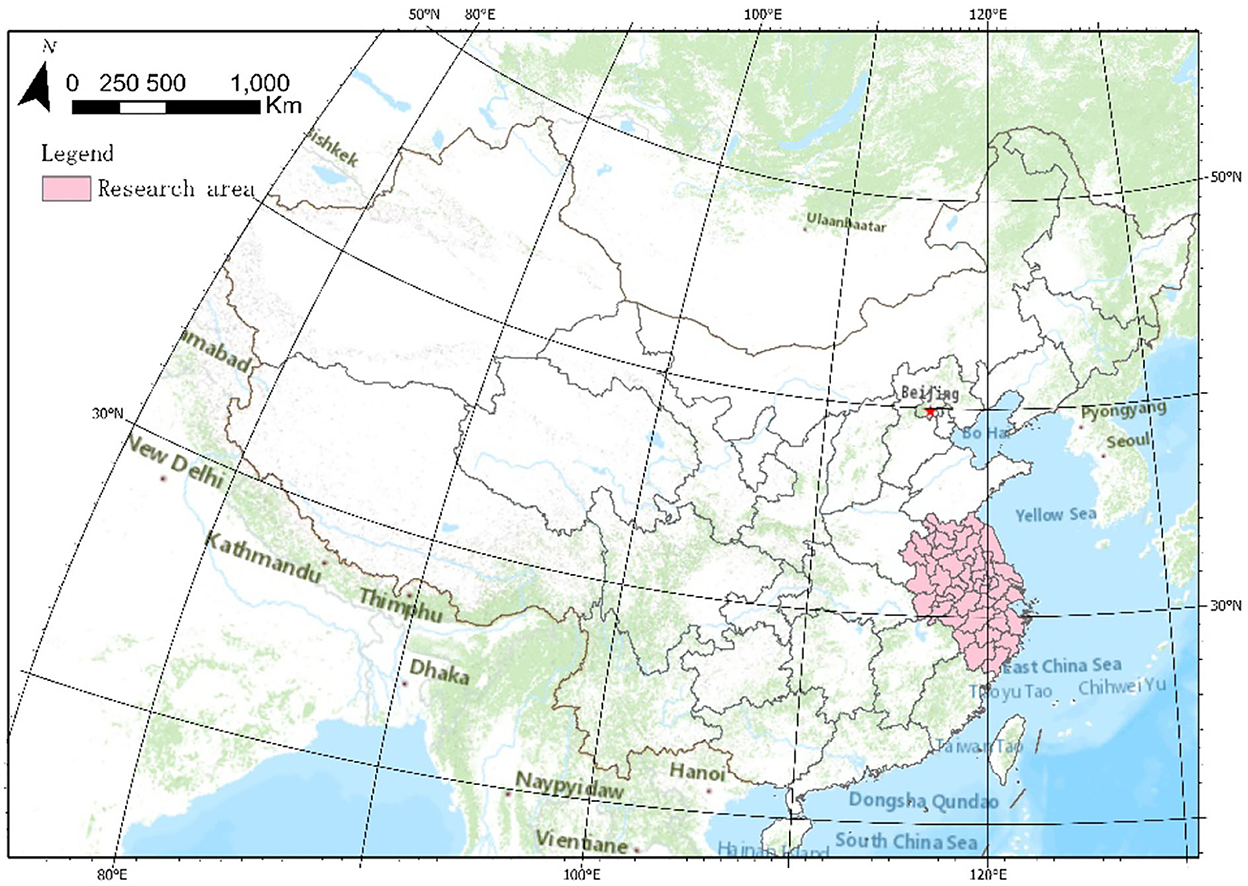
Figure 1. The location of the Yangtze River Delta.
As one of the regions with the most active economy, the greatest degree of openness, and innovative capability, the Yangtze River Delta region has always led other areas of China in terms of urban and rural construction. Moreover, the rural and urban development in this area is quick and relatively complete, however, the development imbalance between urban and rural areas is also prominent. At present, China is actively promoting the integrated development of the Yangtze River Delta by implementing the regional coordinated development strategy. As the development of urban-rural integration is an important part of the integration of the Yangtze River Delta, its experience will undoubtedly have more important reference value and demonstration significance for other regions in China.
3.2. Data collection and cleaning
Relevant data on urban-rural integration development level and the index system of influencing factors mainly come from China Urban Statistical Yearbook, Shanghai Statistical Yearbook, Jiangsu Statistical Yearbook, Zhejiang Statistical Yearbook, and Anhui Statistical Yearbook in 2000, 2005, 2010, 2015, and 2020. At the same time, some of the data come from the corresponding city statistical yearbook of prefectural cities, statistical bulletin of national economic and social development, and government websites. Some missing data were completed by interpolation or estimation.
3.3. Methods
3.3.1. Global principal component analysis
Global principal component analysis (GPCA) replaces the original multidimensional variables with a few unrelated comprehensive variables by dimensionality reduction, to simplify the data structure while retaining most of the original information, which is conducive to facilitating the comprehensive evaluation of the research object (Abdi and Williams, 2010). Generally, Principal component analysis adopts a plane data table composed of indicators and samples, which makes it impossible to conduct a longitudinal comparison of the analysis results of the same sample at different times. However, GPCA takes the time series into account, analyses the unity of stereo time-series data tables, compares the timelines, and to evaluate regional differences, which simplifies the original index system. Moreover, the comprehensive index is independent of each other, which will reflect the original features of the original index as much as possible.
3.3.2. Exploratory spatial data analysis
As a method of analyzing the spatial correlation of data, Exploratory Spatial Data Analysis (ESDA) can explain the spatial correlation characteristics of spatial variables and further explain the spatial clustering state of variables. The measurement indexes used in ESDA include the global Moran index (Geary, 1954), the Moran scatter diagram (Nieto Masot et al., 2020). Therefore, this paper adopts the global Moran index to reflect whether there is an agglomeration trend in the whole space and further explains specific agglomeration types and spatial correlation characteristics through the scatter plot.
3.3.3. Geographical detector
The geographical detector is a spatial algorithm first put forward by scholar Wang and Xu (2017) in 2010 to explore the driving factors (independent variables) affecting dependent variables by using the principle of spatial heterogeneity. The advantages of the geographical detector include: (1) It can not only explore the influence of quantitative data on dependent variables, but also measure the influence of qualitative data on dependent variables. (2) It can explore the interaction between independent variables. The geographic detector was originally used for health risk assessment and has been widely used into research fields such as ecology, meteorology, hydrology and social economy.
Geographic detectors are composed of four main detectors (algorithms), which are factor detector, interactive factor detector, risk detector, and ecological detector. This paper mainly adopts the factor detector to detect spatial distribution heterogeneity of dependent variable Y, and quantifies the influence degree of independent variable X on Y, and uses q value to represent the influence degree of X on Y. Moreover, this paper explores the relationship between independent variables X through the interactive factor detector, which is also known as the interaction between factors.
In the formula, H = 1, L is the stratification of independent variable Y or dependent variable X, namely classification or partition, and Nh and N are the number of units of layer h and the whole region respectively. and σ2 are the variances of the Y values of layer h and the whole region.
3.3.4. Geographical weighted regression model
The geographically weighted regression (GWR) model can be applied to reflect the local characteristics of the relationship between variables and visualizes the different effects of the same index on the regression results in different spaces. This paper aims to explore the specific changes in the size and direction of regression parameters of influencing factors of urban-rural integration development as geographical location changes (Brunsdon et al., 1996).
In this formula, γi is the measure value of urban-rural integration development level, Xij is the influencing factor of urban-rural integration development, (μi, vi) is the spatial coordinate of the ith sample point, and βj(μi, vi) is the kth regression parameter of the ith sample point.
4. Research results
4.1. The measurement of the integrated urban-rural development on the Yangtze River Delta
4.1.1. The evaluation index system of integrated urban-rural development in Yangtze River Delta
To scientifically measure the integrated urban and rural development of urban agglomerations in the Yangtze River Delta, this paper builds the evaluation index system of integrated urban and rural development based on the principles of scientificity, integrity, systematicness, and accessibility, which are shown in Table 1. The index system constructed in this paper includes 17 indicators from six dimensions of “economic integration,” “population integration,” “social integration,” “spatial integration,” “ecological integration,” and “cultural integration.”
(1) Indicators of economic integration
Per capita GDP (X1) in urban and rural areas is an important symbol of urban and rural economic development. The per capita consumption of urban and rural residents (X2) reflects the degree of wealth and economic integration of urban and rural residents. Per capita income of urban and rural residents (X3) reflects the degree of income difference between urban and rural residents. The comparative coefficient of productivity between primary industry and secondary and tertiary industry (X4) is one of the main indicators for measuring the dual economic structure. The larger this indicator is, the smaller the difference between the primary industry and the secondary and tertiary industries. On the contrary, the greater the difference between the two sectors is. Therefore, this indicator is a positive indicator for the level of urban-rural integration development.
(2) Indicators of population integration
The proportion of non-agricultural and agricultural employment (X5) reflects the degree of integration of urban and rural industrial structure and comprehensive service capacity. Population urbanization level (X6) reflects the degree of population integration of urban and rural residents.
(3) Indicators of social integration
Coverage of old-age insurance in urban and rural areas (X7) and Unemployment insurance coverage in urban and rural areas (X8) reflect the level of social welfare and the quality of life of residents. Comparison coefficient of urban and rural medical care (X9) and Medical conditions in urban and rural areas (X10) reflect the level of urban and rural medical and health services and the degree of integrated development of health security of residents.
(4) Indicators of spatial integration
Land urbanization level (X11) reflects the degree of urban spatial expansion. Road network density (X12) reflects the level of interdependence and integration between urban and rural areas supported by the transportation system and infrastructure system.
(5) Indicators of ecological integration
Urban and rural greening level (X13), Urban and rural household garbage disposal (X14) and Urban and rural pollution control (X15) reflect the quality of residents' living environment, the overall ecological environment of the city and the level of sustainable development.
(6) Indicators of cultural integration
Comparison coefficient of education, culture, and entertainment between urban and rural areas (X16) reflects the difference between urban and rural residents in their cultural and educational consumption behavior and their emphasis on spiritual culture. Urban and rural cultural level(X17) reflects the integration level of infrastructure construction of urban and rural science and education activities.
Table 1. An evaluation index system of integrated urban-rural development in Yangtze River Delta.
4.1.2. The results of the development level of urban-rural integration in Yangtze River Delta
After the data are standardized by the standardization method, the data of 17 indicators in 2000, 2005, 2010, 2015, and 2020 were input into the SPSSAU tool for global principal component analysis. The results show that KMO is 0.832, which meets the prerequisite conditions of GPCA, and the data pass the Bartlett sphericity test (P < 0.05), which indicates that the data are suitable for GPCA. Four principal components were extracted according to the standard with an eigenvalue >1, and the cumulative contribution rate reached 65.424%, which could explain the index characteristics well. Each principal component can be obtained according to the principal component load matrix and eigenvalue. The weight of each principal component can be obtained according to the variance contribution rate of each principal component after the score of each principal component was obtained, to calculate the comprehensive value of each sample.
After a lateral analysis of the scores, this paper finds that there are great different differences in the 41 cities in the Yangtze River Delta in terms of the level of urban-rural integration development. There is a wide difference between the scores of the top one Shanghai and the last one Fuyang. It is also noticed that the average score of the urban-rural integration development level of 41 cities in the Yangtze River Delta in 2000, 2005, 2010, 2015, and 2020 is −0.114, 0.058, 0.060, 0.061, 0.021, and −0.065 respectively, which means that the development level of urban-rural integration in the Yangtze River Delta presents a slight fluctuating upward trend overall. The standard deviations of the development level of urban and rural integration in the 41 cities in the Yangtze River Delta show small fluctuations but retaining same basically. However, the range first rises and then declines, and shows an obvious declining trend, which indicates the gap between 41 cities in the Yangtze River Delta shrinks in terms of urban and rural integration development shrinks gradually and the regional imbalance has been improved (as shown in Figure 2). It's found by comparing chronologically: During the urban-rural integration development from 2000 to 2020, the urban-rural integration development of most cities has been improved, especially Huzhou with an increase of 1.3 points, and has risen 15 in the ranking of urban-rural integration of urban agglomerations in the Yangtze River Delta. It reflects that the urban-rural integration development of Huzhou city has received great attention and support in the past 20 years. However, some cities, the level of urban-rural integration development declines greatly in cities such as Huainan, Tongling, Bengbu, Shanghai, Jinhua, Huai'an, Fuyang, Shaoxing and Zhenjiang, reflecting the widening gap between urban and rural areas in these cities during this period, with cities becoming stronger and villages weaker and in slow development.
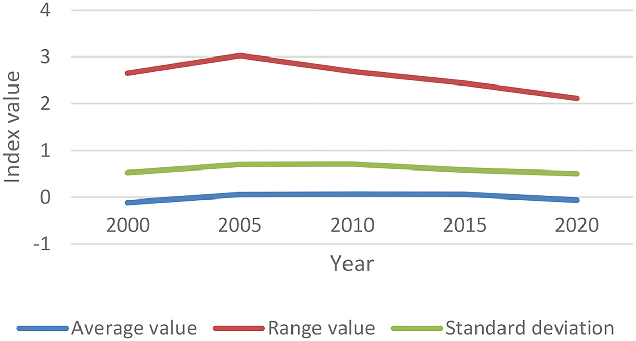
Figure 2. Evolution of integrated urban-rural development level in the Yangtze River Delta.
4.2. The spatial differences of the integrated urban-rural development in the Yangtze River Delta
4.2.1. Spatial layout of the integrated urban and rural development in the Yangtze River Delta
To more intuitively analyze urban-rural integration development in 41 cities of the Yangtze River Delta spatially and temporally, this paper adopts ArcGIS software to analyze the urban-rural integration level of 41 cities in 2000, 2005, 2010, 2015, and 2020, and draws a five-bit-map by the nature breaks to visually express the spatial characteristics (as shown in Figure 3).
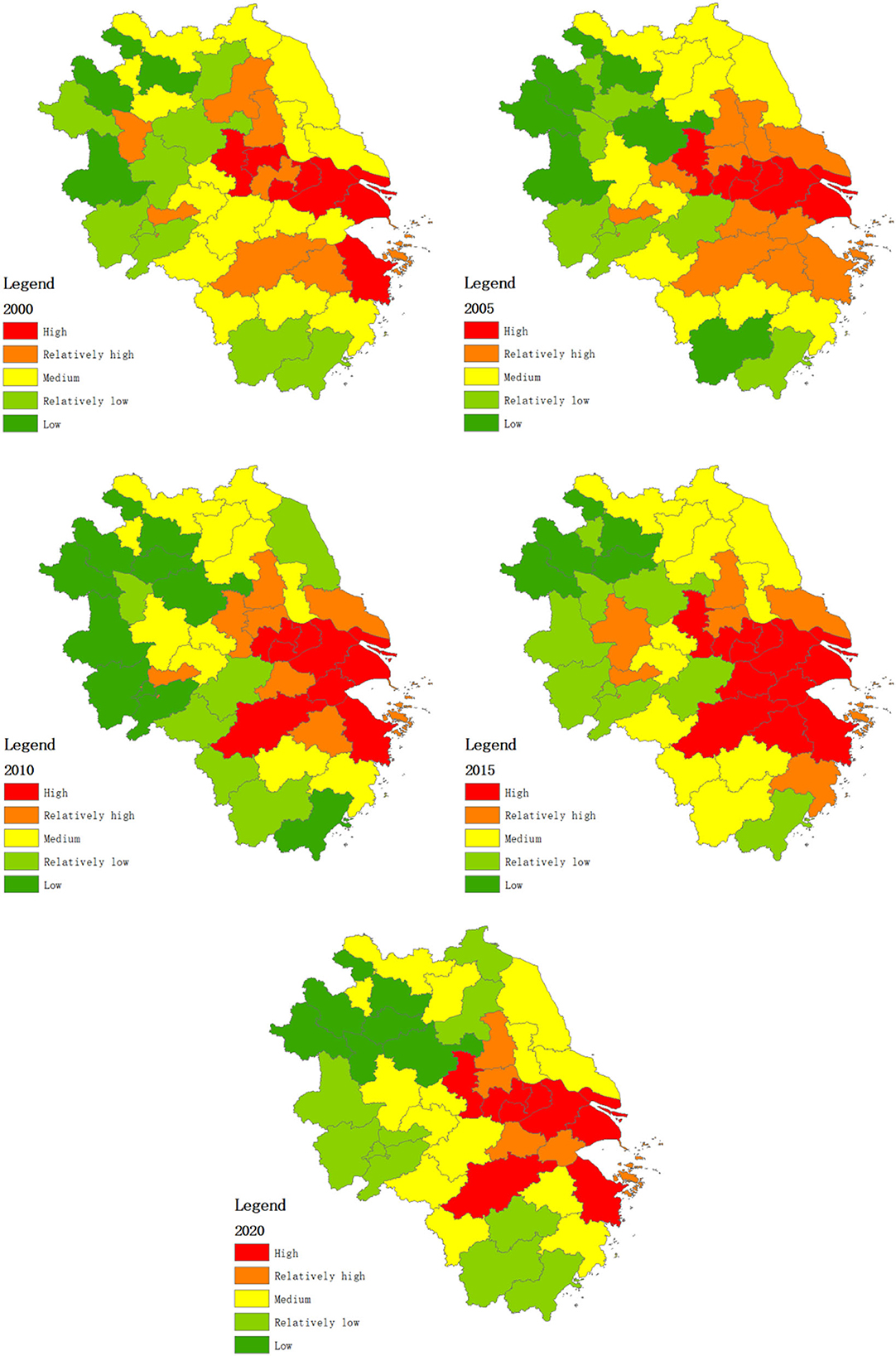
Figure 3. Distribution of integrated development level in 41 cities of Yangtze River Delta.
We can see: (1) the integrated urban-rural development in the Yangtze River Delta shows a significant spatial differentiation, the places of highly integrated level are mainly distributed in the eastern and central part of the Yangtze River Delta, including Shanghai, Suzhou, Wuxi, Changzhou, Nanjing, Hangzhou, Ningbo, while the places of low integration are distributed in the northeast of the Yangtze River Delta, including Fuyang, Bozhou, Suzhou, Bengbu, Huainan and Chuzhou in Anhui Province. All these cities are at a relatively low economic level, which are of strong urban-rural development differences and in a prominent dual structure. (2) Central cities play a strong radiating role. The level of integrated development decreases from the center cities Shanghai, Suzhou, Nanjing and Hangzhou to the peripheral cities, which attributes to the factors, such as geographical location, social economy, urban and rural circulation.
4.2.2. Spatial differences of integrated urban-rural development in the Yangtze River Delta
At first, Moran's I is applied to research the spatial agglomeration of urban-rural integration development level. Moran's I values (2000, 2005, 2010, 2015, and 2020) are all positive, and all p-values pass the significance test of 5%, which indicates that the integrated urban-rural development in 41 cities of Yangtze River Delta show clear features of spatial autocorrelation and agglomeration. We can also see that the spatial agglomeration of urban-rural integration development in the Yangtze River Delta shows an upward trend at first and then a downward trend, and gradually show a more decentralized and homogeneous spatial distribution.
However, Moran's I index can just be used to elaborate if there is a spatial autocorrelation in the whole research region and calculate the agglomeration level, while the spatial correlation of different regions varies from each other.
To further quantitatively analyse the spatial differentiation of integrated urban-rural development in the Yangtze River Delta, this paper adopts the Moran's I scatter plot drawn by local spatial autocorrelation analysis to analyse the local characteristics of the spatial agglomeration of 41 cities in the Yangtze River Delta. It can be seen directly from Figure 4 that most cities are in the HH and LL quadrants. In terms of the scatter spot: the percentage of points distributed in the first and third quadrants was 71% in 2000, 81% in 2005, 83% in 2010, 83% in 2015, and 73% in 2020, showing the obvious spatial agglomeration characteristics of urban-rural integration in the 41 cities in the Yangtze River Delta.
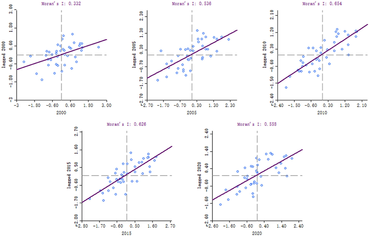
Figure 4. Moran's I scatter points in 41 cities of the Yangtze River Delta.
It can be seen from Table 2 that cities such as Shanghai, Nanjing, Wuxi, Changzhou, Suzhou, Yangzhou, Zhenjiang, Ningbo, Jiaxing, and Zhoushan have always been the HH cluster type from 2000 to 2020, all of which are in a relatively high level of urban-rural integration development and with positive spatial autocorrelation.
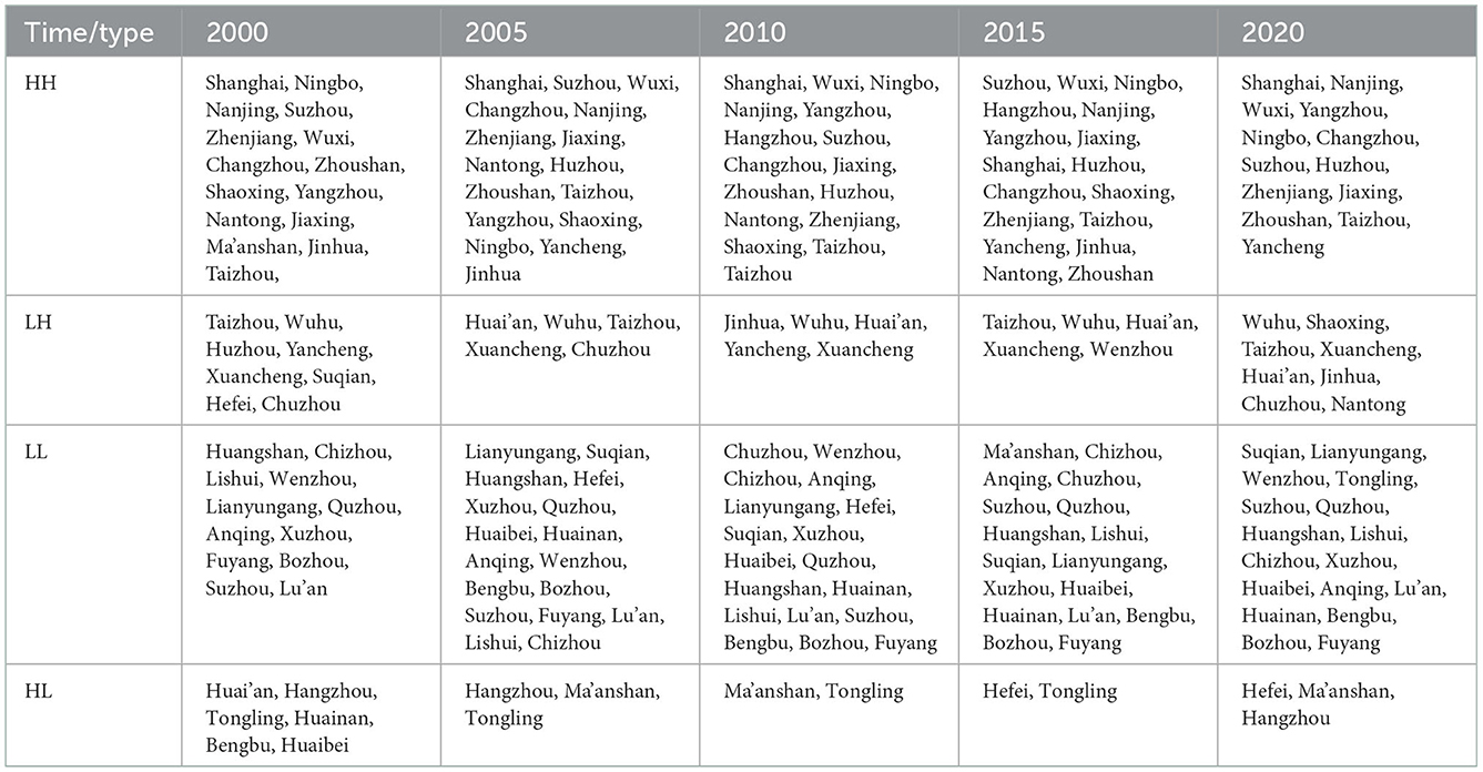
Table 2. Urban distribution based on Moran's I scatter.
The HH cluster type of spatial distribution gradually spreads northward and westward over time. Cities such as Yancheng, Taizhou and Huzhou have changed from LH cluster type to HH cluster type, which indicates that the urban-rural integration development level of surrounding areas is gradually improving while spatial agglomeration is enhancing.
At the same time, the northwest and west edge of the Yangtze River Delta show an agglomeration trend, including cities such as Xuzhou, Lianyungang, Quzhou, Lishui, Anqing, Huangshan, Fuyang, Suzhou, Lu'an, Bozhou, and Chizhou, all of which are agglomeration areas with a lower level of urban-rural integration development. From the perspective of spatial distribution, the inner regions of the Yangtze River Delta continue to show an agglomeration trend from 2000 to 2010. However, since 2010, the scope of regions of LL agglomeration starts to concentrate on the marginal areas, but the scope was still larger than that of 2000. Places such as Suqian, Wenzhou, Bengbu, Huainan, Huaibei, and Tongling have changed from LH and HL agglomeration to LL agglomeration, which shows that the urban-rural integration development level is getting closer to that of the surrounding areas, or in other words, the integrated urban-rural development of those cities is relatively reduced.
4.3. The influencing factors of spatial differences in integrated urban-rural development in the Yangtze River Delta
4.3.1. Selection of influencing factors
The level of integrated urban-rural development is influenced by comprehensive factors such as economy, culture, infrastructure, people's livelihood, and government policy management. As a result of the continuous accumulation and interaction of these factors, the levels of regional integrated urban-rural development in different regions will differ. To study the influencing factors of spatial differences in urban-rural integration development in the Yangtze River Delta, this paper selects seven indicators in terms of the economic development, industrial structure, government support, science and education level, medical foundation, people's livelihood, and infrastructure. The specific indicators are shown in Table 3. The indicators are selected according to the regional revenue above the line is important evidence to elaborate the regional economic development, thus it is always used to describe the factors that influence economic development. The percentage of employees in the tertiary industry reflects the regional employment and industrial structure to a certain degree, thus this indicator can show the reasonableness of the industrial structure. Therefore, this paper selects this indicator to elaborate the factor of industrial structure. The expenditure of science and technology in the fiscal expenditure can not only reflect the government's fiscal support, but also indicate the capacity of scientific and technological innovation, thus this indicator is chosen to reflect governmental governance and support.
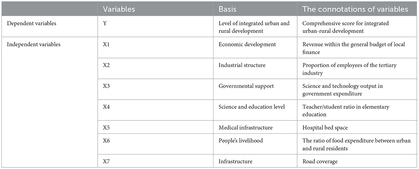
Table 3. Influencing factors of urban-rural integration development level.
The teacher-student ratio of elementary education can not only reflect the construction level of basic education facilities in a region, but also the comprehensive quality of the labor force in the region, thus it is used to describe the factors of science and education level. The hospital bed space can reflect the development level of regional medical infrastructure, the convenience of people's life, and the strength of medical security, which can be used to describe basic medical factors. The ratio of food expenditure between urban and rural residents not only reflects the difference between the living standards of urban and rural residents in the region, but also the regional consumption expenditure, thus this paper adopts this indicator to describe people's living factors. Road coverage reflects the level of infrastructure construction in a region, which is used to describe infrastructure factors.
4.3.2. Analysis of influencing factors of integrated urban-rural development based on geographical detector
First, this paper adopts ArcGIS to rasterize the independent variables which are discretized according to the classification of natural breakpoints. Next, the correlation factors of the development level of urban-rural integration are explored and interaction detection is conducted by geographical detector to find out the relation between the urban and rural integration development level (Y) and economic development, industrial structure, government support, science and education level, health, people's living standards and infrastructure (X) and the interaction relationship between the driving forces. All of these will provide a decision-making reference for the integrated urban and rural development of the Yangtze River Delta.
STEP1: Factor detection can be used to detect the spatial differentiation of urban-rural integration development and the extent to which each driving factor explains the spatial difference of integrated urban-rural development. The results are shown in Table 4.
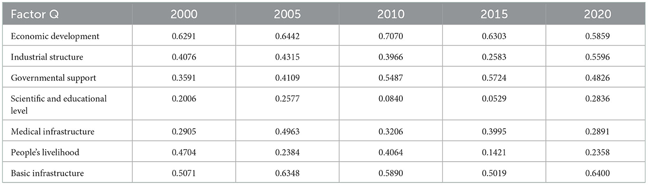
Table 4. Factor detection results of influencing factors of integrated urban-rural development.
It can be seen from the results of factor detection that the average p of the economic development index from 2000 to 2020 is greater than that of other indicators, which indicates that the local revenue above the line is the most important factor influencing the level of integrated urban-rural development, and the integrated urban-rural development has the strongest correlation with the revenue above the line. For regions with a weak economic foundation, revenue above the line can advance the development of infrastructure and public services effectively on the one hand, and improve economic development on the other hand, which will finally improve integrated urban and rural development.
The infrastructure factor is the second important factor for rural development, and the improvement of infrastructure is a prerequisite to improve the livelihood of residents, especially rural residents' living standards, to meet the needs for a portable and efficient life, to improve the quality of urban and rural social development, narrow the gap between the urban and rural areas, and improve the level of urban and rural integration development. Government fiscal support is also the main factor affecting urban and rural integration, science and technology spending not only reflects the degree of government financial support to the urban areas and illustrates the science and technology development of cities. More specifically, the higher scientific and technology spending, the greater support for the development of science and technology. Moreover, the improvement of science and technology can improve overall regional development and improve integrated urban and rural development.
The next is the factor of industrial structure, which is only second to government support. Generally, the degree of regional economic development is positively correlated with industry development, especially with the optimization and upgrade of industrial structure, the proportion of the tertiary industry will improve, more and more practitioners will work in the tertiary industry, and the regional economic development level will grow rapidly. A rational industrial structure has laid a solid material foundation for integrated urban and rural development. The q value of the basic medical factor doesn't change so much, indicating that the influence of hospital bed space has a constant and weak influence on the development of urban-rural integration. The q of factors such as people's life &science and education level are small, which can be explained by the reason that as China becomes stronger, the expenditure and technical support on food production and the development of basic education account little in the overall expenditure of urban and rural residents. Moreover, the popularization of nine-year compulsory education has greatly improved the living standards of residents.
STEP2: The interaction detector can detect whether there is an interaction between different influencing factors, and judge whether the interaction type of the two factors will increase or weaken the explanatory power of integrated urban-rural development. From the result of interaction detection (Table 5), the interaction between the influence factors of urban and rural integration development shows the features of a double factor enhancement and Non-linear enhancement. Double factor enhancement shows that the explanatory power of the interaction of the influencing factors is greater than that of each factor. The non-linear enhancement shows that the explanatory power of the interaction of the influencing factors is greater than the sum of the explanatory powers of each factor. The non-linear enhancement effect is greater than the double factor enhancement, which demonstrates that the interaction of any two factors will cause a greater influence on the development of urban and rural integration than an individual one, which indicates that the urban and rural integration development of cities in the Yangtze River Delta is the result of the comprehensive correlation of various influencing factors.
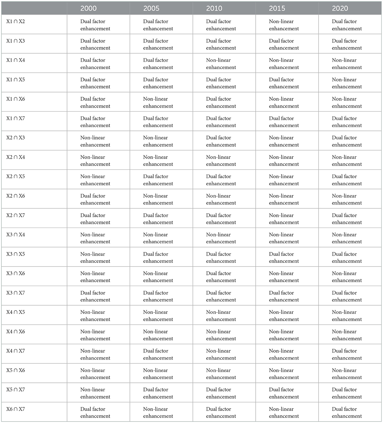
Table 5. Interactive detection results of influencing factors of integrated urban-rural development.
By analyzing the above factor detection, we can find that the single factor of teacher/student ratio in basic education (X4), the ratio of food expenditure rate between urban and rural areas (X7) and hospital bedspace (X6) have little influence on the urban-rural integration development in cities of Yangtze River Delta, but when they interact with economic development, government support, infrastructure, industrial structure, and other factors, their influence will be significantly enhanced as the level of urban and rural integration upgrades. Amid the background of China's rural revitalization strategy, promoting the integrated urban-rural development is a complex and comprehensive project, a process of economic, social, demographic, and ecological coupling between urban and rural areas, and the result of various internal and external factors.
4.3.3. Analysis of the influence of various factors on spatial differentiation based on geographical weighted regression model
Since there is heterogeneity in the integrated urban and rural development, this paper analyses the influence of different variables on different areas to learn more about the regression relations of the local space between independent variables and dependent variables in the Yangtze River Delta. The following paragraph takes the data in 2020 as an example to conduct a geographically weighted regression analysis, and the bandwidth is determined according to “The AICc minimum criterion” for regression, and the coefficient of determination is 0.7285, which indicates a good degree of the fitting.
The GWR regression coefficients can clearly explain the relationship between influence factors and the space differentiation of urban and rural integration development. A positive regression coefficient means that the dependent variable has a positive effect on the independent variables. To put it more specifically, the greater the dependent variables, independent variables will play a greater role in promoting the independent variables. On the contrary, a negative regression coefficient means that the larger the dependent variables, the greater inhibiting effect the independent variables will have. Once the regression coefficients of all variables obtained from regression analysis are displayed in the ArcGIS, they can more intuitively reflect the impact of each independent variable on the spatial distribution of integrated urban-rural development, and the regression coefficients of all variables can be divided into 7 categories according to nature breaks, which are shown in Figure 5.
(1) The impact of economic development on spatial differentiation of urban-rural integration
The revenue above the line is an important indicator to illustrate the degree of regional economic development, and urban-rural integration is closely related to economic development. Economic development can promote regional productivity and industrial structure optimization, and then improve people's income and living standards. The regression results of GWR show that the influence of revenue above the line on urban-rural integration development of the Yangtze River Delta decreases from west to east, with the areas of high value mainly distributed in the westernmost Anqing, Huaizhou, and Lu'an, while the low-value areas distributing in the eastern part of Yangtze River Delta, especially in the eastern part of Zhejiang Province, such as Zhoushan, Shanghai, Suzhou, Jiaxing, Ningbo, Shaoxing, Taizhou. Among them, the one with the maximum value is Fuyang city, and the one with the minimum value is Zhoushan city.
(2) The impact of labor structure on spatial differentiation of urban-rural integration
The proportion of employees in the tertiary industry of urban and rural areas not only reflects the employment of urban and rural areas but also indicates the difference between industrial structure between urban and rural areas. GWR regression results show that the proportion of employees in the tertiary industry can influence the degree of urban-rural integration in the Yangtze River Delta, which decreases from the northeast to the southwest, and the places with high values include Lianyungang, Yancheng, Nantong, Yangzhou and Taizhou, and places with low values include Wenzhou, Lishui, Jinhua, and Quzhou.
(3) The impact of science and technology expenditure on spatial differentiation of urban-rural integration
As the primary productive forces, science and technology directly affect the innovation level and economic vitality of a city. On the one hand, the expenditure on science and technology reflects the level of science and education development of a city, on the other hand, it also reflects the government's financial support for local economic and social development. GWR regression results show that the impact of science and technology expenditure on urban-rural integration development in the Yangtze River Delta is higher in the west and lower in the middle. The high-value areas include Anqing and Lu'an, while the low-value areas include Xuancheng, Changzhou, and Zhenjiang.
(4) Influence of teacher-student ratio in basic education on the spatial differentiation of integrated urban-rural development
On the one hand, the teacher-student ratio in basic education reflects the differences in educational resources, the social and cultural environment, on the other hand, it also reflects the differences in the quality of the labor force. GWR regression results indicate that the influence of the ratio of teachers and students of basic education in the Yangtze River Delta on urban and rural integration development decreases from northwest to southeast gradually, and high value areas including Haozhou, Fuyang, Huaibei, Suzhou, Xuzhou, Bengbu, Huainan, and Lu'an, while the districts of low value include Zhoushan, Ningbo, Taizhou and Wenzhou.
(5) Influence of hospital bed-space on spatial differentiation of urban-rural integration
The number of hospital bedspace reflects the differences between urban and rural medical resources, hospital infrastructure, and the convenience degree of people's living. The results of GWR regression show that the hospital bedspace in the Yangtze River Delta is high in the middle and low in the surrounding areas. The high-value areas include Wuxi, Changzhou, Zhenjiang, Xuancheng, Huzhou, and Hangzhou, and the areas of low value including Anqing, Lu'an, and Chizhou.
(6) The influence of the ratio of food expenditure between urban and rural residents on spatial differentiation of urban-rural integration
The ratio of food expenditure rate between urban and rural residents reflects the difference in people's living standards, affluence, and consumption capability between urban and rural residents. GWR regression results show that the ratio of the food expenditure rate of urban residents to the food expenditure rate of rural residents in the Yangtze River Delta is higher in the southeast and northwest, and lower in the central and western regions. Places of high value include Ningbo, Taizhou, Shaoxing, Wenzhou, Jinhua, Lishui, and Hangzhou, while places of low value include Chizhou, Tongling, and Wuhu, reflecting that the integrated urban-rural development in these areas has not been significantly affected by the ratio of food expenditure rates between urban and rural residents.
(7) Impact of road coverage on spatial differentiation of urban-rural integration
Road coverage reflects the development of infrastructure in the region, the living standard of the people in the region, and the government's financial investment in the region. GWR regression results show that the influence of road coverage rate decreases from the southeast to the northwest and the central and western regions have the lowest values. The high-value areas include Zhoushan, Ningbo, Taizhou, Shaoxing, Wenzhou, Jinhua, and Lishui, while the low-value areas included Anqing, Chizhou, Tongling, and Wuhu.

Figure 5. Spatial distribution of GWR regression coefficients in 41 cities of Yangtze River Delta.
5. Conclusions and recommendations
5.1. Conclusions
First, from 2000 to 2020, the overall integrated urban-rural development in the Yangtze River Delta shows a fluctuating upward trend, and the gap between urban-rural integration development among 41 cities in the Yangtze River Delta gradually narrows, but the development within the is still significantly imbalanced.
Second, the integrated rural-urban development in the Yangtze River Delta shows a strong inclination toward spatial agglomeration, and the development of cities with a low level of integration development can be promoted by taking advantage of the driving effect of areas of a high degree of rural-urban integration.
Third, the integrated urban-rural development in the Yangtze River Delta shows strong spatial differentiation, with the integration level in the eastern part of the Yangtze River Delta being higher, while it's low in the northwest part, which indicates a prominent imbalanced distribution.
Fourth, economic development, infrastructure, government support, and industrial structure are the main factors affecting rural-urban integration development. GWR regression results show that the same factors have different impacts on rural-urban integration development in different regions.
The conclusion indicates that the integrated development of the 41 cities is not balanced and there is a great difference between different cities. The integrated development of this area has shown the apparent feature of geographical agglomeration, or in other words, the central cities have become the forces that drive the development of neighboring cities. Since the integrated urban-rural development is influenced by economic development, basic infrastructure, government support, and industrial structure, to improve the urban-rural integration development of 41 cities in the Yangtze River Delta and promote the overall development, prefecture-level cities need to identify their advantages and disadvantages while taking local realities into account, formulate targeted solutions to the problems, strive to develop the economy, actively improve infrastructure construction, and formulate relevant policies according to their local conditions to promote integrated urban and rural development.
5.2. Recommendations
Based on the results, we put forward suggestions for the formulation of policies in terms of the economy, infrastructure, financial expenditure, the people's life, and space layout to improve the development level of urban and rural integration of the Yangtze River Delta, which will enlighten the formulation of new countermeasures and policies to advance the urban and rural integration development of the Yangtze River Delta, and are of reference meaning for other areas to improve the level of urban and rural integration development.
(1) Promoting local economy
Economic development is the basis of urban-rural integration. According to the results of the geographical detector, economic development degree has the greatest influence on urban-rural integration development. GWR analysis results show that economic development indicators have the most significant influence on the level of urban-rural integration in the western part of the Yangtze River Delta, especially in Lu'an, Anqing, and Chizhou. Since economic growth largely depends on investment, the western region of Anhui Province should actively introduce science and technology and high-end manufacturing industries, learn the development route of Hefei, and reduce the proportion of industries with high pollution and low energy production. It is necessary to increase fiscal investment in backward and rural areas, give full play to the driving role of government policies, and promote factor flow between urban and rural areas. At the same time, it's suggested to change traditional agricultural production methods, improve agricultural productivity, improve rural markets, as well as increase farmers' income in a diversified way, attract factors such as the labor force to return to rural areas, and revitalize rural economic and social development. At the same time, urban areas should improve the quality of industrial development, gradually increase the contribution rate of the tertiary industry to economic aggregate, promote the development of industrial clusters, and pay attention to the coordinated development of urban and rural industries.
(2) Strengthening infrastructure
Rural infrastructure is the main task of integrated urban-rural development, and the results of the GWR analysis show that the infrastructure in the southeastern Yangtze River Delta region has the most significant influence on urban and rural integration development. Due to the influence of the geographical environment, the economic development conditions in the region are poor, and the infrastructure construction is still not perfect. It's difficult for rural areas to rely on themselves to develop infrastructure quickly, thus it's suggested to Increase investment in the construction of rural public facilities, public service facilities, environmental infrastructure, information infrastructure, etc., optimize the construction of regional road network, comprehensively open up the transportation network between urban and rural areas, and improve the level of urban-rural integration through sustainable transportation development. Moreover, it's suggested to increase employment opportunities in rural areas to improve the employment situation of the rural labor force and avoid the problem of hollow villages caused by population loss. Finally, it's necessary to improve rural road transportation, strengthen rural Internet, and enhance farmers' access to information.
(3) Improving the government expenditure policy
It's suggested to increase the proportion of agricultural expenditure in government spending, improve the structure of government supply, ensure that government input contributes to the realization of rural revitalization, and attract more nongovernmental capital to rural areas. GWR results show that government support plays a significant role in urban-rural integration in the western Yangtze River Delta, especially Anqing and Lu'an, thus these two places should increase financial support to rural areas. What's more, it's also urgent to improve the social security system in rural areas, improve the quality and quantity of security facilities to ensure that rural residents and urban residents enjoy relatively equal social services, and attract more population to move to rural areas, to alleviate the population pressure in urban areas.
(4) To improve people's living standards
The residents' living standards should be improved by granting them with better material support and enriching their spiritual and cultural life. It's suggested to strengthen the construction of natural ecological protection in rural areas, improve the living environment of rural residents, and build beautiful and livable villages. It is also important to increase investment in education and culture in rural areas, improve the education level of rural residents, promote the sinking of urban education resources, and constantly narrow the gap between the educational resources and cultural resources enjoyed by urban and rural residents. Moreover, it's also of paramount importance to implement poverty alleviation policies and measures, improve the subsistence allowance system, help people in need, and ease urban-rural tensions.
(5) To optimize the spatial layout of urban and rural areas
The Yangtze River Delta is suffering from a serious imbalanced urban-rural integration development. The urban-rural integration in the eastern part of the Yangtze River Delta is high and shows a great inclination toward agglomeration. Therefore, it is suggested to focus on the optimization of spatial distribution, give full play to the driving role of central cities, cultivate economic agglomeration belt and growth pole, strengthen urban-rural connection and advance factor flow. Last, it's necessary to focus on the central city of Shanghai, Hangzhou, Nanjing, Hefei, and other provincial capital cities, give full play to the main cities to drive the development of peripheral and secondary cities and villages, accelerate to form a rational layout and closely connected factor flow mechanism, in such a way to improve the integrated urban-rural development.
Data availability statement
The original contributions presented in the study are included in the article/supplementary material, further inquiries can be directed to the corresponding author.
Author contributions
NL: conceptualization, methodology, and writing—original draft. YC: data curation and formal analysis. FS: writing—original draft. All authors contributed to the article and approved the submitted version.
Funding
This research was funded by the National Natural Science Foundation of China, grant 42071159.
Conflict of interest
The authors declare that the research was conducted in the absence of any commercial or financial relationships that could be construed as a potential conflict of interest.
Publisher's note
All claims expressed in this article are solely those of the authors and do not necessarily represent those of their affiliated organizations, or those of the publisher, the editors and the reviewers. Any product that may be evaluated in this article, or claim that may be made by its manufacturer, is not guaranteed or endorsed by the publisher.
References
Abdi, H., and Williams, L. J. (2010). Principal component analysis. Wiley Interdiscipl. Rev. 2, 433–459. doi: 10.1002/wics.101
Ann, T., Wu, Y., Zheng, B., Zhang, X., and Shen, L. (2014). Identifying risk factors of urban-rural conflict in urbanization: A case of China. Habitat. Int. 44, 177–185. doi: 10.1016/j.habitatint.2014.06.007
Bennett, K. J., Yuen, M., and Blanco-Silva, F. (2018). Geographic differences in recovery after the great recession. J. Rural Stud. 59, 111–117. doi: 10.1016/j.jrurstud.2018.02.008
Brunsdon, C., Fotheringham, A. S., and Charlton, M. E. (1996). Geographically weighted regression: a method for exploring spatial nonstationarity. Geogr. Anal. 28, 281–298. doi: 10.1111/j.1538-4632.1996.tb00936.x
Castells, M. (1989). The Informational City: Information Technology, Economic Restructuring, and the Urban-Regional Process [M]. Blackwell Oxford.
Castle, E. N., Wu, J., and Weber, B. A. (2011). Place orientation and rural–urban interdependence. Appl. Econ. Perspect. Policy 33, 179–204. doi: 10.1093/aepp/ppr009
Chen, K., and Long, H. (2019). Impacts of land market on urban-rural integrated development in China. J. Nat. Resourc. 34, 221–235. doi: 10.31497/zrzyxb.20190201
Chen, X., and Li, C. (2004). Study on urbanization and urban-rural integration in China. Urban Stud. 11, 41–45.
Chung, S. (2017). The effect of urban to rural migrants' social capital on the development of rural areas. Community Soc. 18, 79–99.
Davoudi, S. (2002). Urban-rural relationships: An introduction and brief history. Built Environ. 28, 269–277. doi: 10.2307/23287748
Douglass, M. (1998a). Rural-Urban Linkages and Poverty Alleviation: Toward a Policy Framework; Proceedings of the International Workshop on Rural-Urban Linkages. Curitiba.
Douglass, M. (1998b). A regional network strategy for reciprocal rural-urban linkages: an agenda for policy research with reference to Indonesia. Third World Plann. Rev. 20, 1–34. doi: 10.3828/twpr.20.1.f2827602h503k5j6
Epstein T. S, and Jezeph, D.. (2001). Development—there is another way: a rural–urban partnership development paradigm. World Dev. 29, 1443–1454. doi: 10.1016/S0305-750X(01)00046-8
Fields, G. S. (2005). A welfare economic analysis of labor market policies in the Harris–Todaro model. J. Dev. Econ. 76, 127–146. doi: 10.1016/j.jdeveco.2003.10.003
Fujita, M., Krugman, P., and Venables, A. (1999). The Spatial Economy: Cities, Regions, and International Trade. Cambridge, MA: The MIT Press. doi: 10.7551/mitpress/6389.001.0001
Geary, R. C. (1954). The contiguity ratio and statistical mapping. Incorporat. Statistician 5, 115–146. doi: 10.2307/2986645
Graeml, K. S., and Graeml, A. R. (2004). Urbanization solutions of a third world country's metropolis to its social environment challenges. J. Urban Econ. 8, 36–51.
Guo, Y., and Xu, J. (2013). Spatial and temporal evolution of urban-rural integrated development levels in Jiangsu Province, China. Region. Sci. Policy Pract. 5, 323–341. doi: 10.1111/rsp3.12012
Herberholz, C., and Phuntsho, S. (2018). Social capital, outpatient care utilization and choice between different levels of health facilities in rural and urban areas of Bhutan. Soc. Sci. Med. 211, 102–113. doi: 10.1016/j.socscimed.2018.06.010
Hommes, L., and Boelens, R. (2017). Urbanizing rural waters: Rural-urban water transfers and the reconfiguration of hydrosocial territories in Lima. Polit. Geogr. 57, 71–80. doi: 10.1016/j.polgeo.2016.12.002
Howard, E. (1898). Tomorrow, A Peaceful Path to Real Reform. Garden Cities of Tomorrow [M]. London: ATC Books/Faber and Faber.
Isserman, A. M. (2005). In the national interest: Defining rural and urban correctly in research and public policy. Int. Reg. Sci. Rev. 28, 465–499. doi: 10.1177/0160017605279000
Ji, X., Ren, J., and Ulgiati, S. (2019). Towards urban-rural sustainable cooperation: Models and policy implication. J. Clean. Prod. 213, 892–898. doi: 10.1016/j.jclepro.2018.12.097
Kai, S., and Jiahao, L. (2015). Construction of urban-rural integration evaluation system in Nanchang City and empirical studies. J. Landscape Res. 2015, 7. doi: 10.16785/j.issn1943-989x.2015.05.009
Krugman, P. (1991). Increasing returns and economic geography. J. Polit. Econ. 99, 483–499. doi: 10.1086/261763
Kūle, L. (2014). Urban–rural interactions in Latvian changing policy and practice context. Euro. Plan. Stud. 22, 758–774. doi: 10.1080/09654313.2013.772785
Liu, J., and Li, Y. (2011). An analysis on urban-rural conflict and cause of formation in the rapid process of urbanization. Theoretical Issues 12, 5–9. doi: 10.18306/dlkxjz.2018.05.002
Liu, Y. (2018). Research on the urban-rural integration and rural revitalization in the new era in China. Acta Geograph. Sinica 73, 637–650. doi: 10.11821/dlxb201804004
Liu, Y., and Li, Y. (2017). Revitalize the world's countryside. Nature 548, 275–277. doi: 10.1038/548275a
Liu, Y., Lu, S., and Chen, Y. (2013). Spatio-temporal change of urban–rural equalized development patterns in China and its driving factors. J. Rural Stud. 32, 320–330. doi: 10.1016/j.jrurstud.2013.08.004
Luo, Y., and Li, T. (2005). Analysis on the systematic function of urban-rural integration in China. Human Geogr. 20, 47–51.
Lynch, K. (2005). Rural-Urban Interaction in the Developing World [M]. Taylor & Francis. doi: 10.4324/9780203646274
Ma, C., Jiang, Y., and Qi, K. (2021). Investigating the urban–rural integrated town development strategy on the basis of the study of rural forms in Nantong, China. Front. Architect. Res. 10, 190–201. doi: 10.1016/j.foar.2020.06.001
Ma, L., Liu, S., Fang, F., Che, X., and Chen, M. (2020). Evaluation of urban-rural difference and integration based on quality of life. Sustain. Cities Soc. 54, 101877. doi: 10.1016/j.scs.2019.101877
Ma, Y. J., Zhang, X. L., and Zhang, C. H. (2006). Spatial evolution and differentiation of urban-rural areas in Jiangsu Province. J. Anhui Agri. Sci. 22, 5983–5986.
Mcgee, T. G. (1989). Urbanisasi or Kotadesasi?: Evolving patterns of urbanization in Asia. Urbanization Asia 1989, 93–108. doi: 10.1515/9780824890650-008
Miszak, N., and Monsutti, A. (2014). Landscapes of power: local struggles and national stakes at the rural-urban fringe of Kabul, Afghanistan. J. Peasant Stud. 41, 183–198. doi: 10.1080/03066150.2014.886566
Murdoch, J. (2000). Networks—a new paradigm of rural development? J. Rural Stud. 16, 407–419. doi: 10.1016/S0743-0167(00)00022-X
Natsuda, K., Igusa, K., Wiboonpongse, A., and Thoburn, J. (2012). One Village One Product–rural development strategy in Asia: the case of OTOP in Thailand. Canad. J. Dev. Stud. 33, 369–385. doi: 10.1080/02255189.2012.715082
Nieto Masot, A., Cardenas Alonso, G., and Engelmo Moriche, A. (2020). Spatial analysis of the rural-urban structure of the spanish municipalities. Int. J. Geo-Informat. 9, 213. doi: 10.3390/ijgi9040213
Potter, R. B., and Unwin, T. (1995). Urban-rural interaction: physical form and political process in the Third World. Cities 12, 67–73. doi: 10.1016/0264-2751(95)91866-E
Preston, D. A. (1975). Rural-urban and inter-settlement interaction: Theory and analytical structure. Area 1975, 171–174.
Salvati, L., and Carlucci, M. (2011). The economic and environmental performances of rural districts in Italy: Are competitiveness and sustainability compatible targets? Ecol. Econ. 70, 2446–2453. doi: 10.1016/j.ecolecon.2011.07.030
Tacoli, C. (1998). Rural-urban interactions: a guide to the literature. Environ. Urban. 10, 147–166. doi: 10.1177/095624789801000105
Tacoli, C. (2002). Changing Rural-Urban Interactions in Sub-Saharan Africa and Their Impact on Livelihoods: A summary. London: International Institute for Environment and Development (IIED).
Tang, D., Mao, M., Shi, J., and Hua, W. (2021). The spatio-temporal analysis of urban-rural coordinated development and its driving forces in Yangtze River Delta. Land 10, 495. doi: 10.3390/land10050495
Wang, J. F., and Xu, C. (2017). Geodetetor: Principle and prospective. Acta Geograph. Sinica 72, 116–134.
Wang, M., Yang, Y., and Guo, T. (2021). Measurement of urban–rural integration level in suburbs and exurbs of big cities based on land-use change in Inland China: Chengdu. Land 10, 474. doi: 10.3390/land10050474
Wang, Y., Liu, Y., Li, Y., and Li, T. (2016). The spatio-temporal patterns of urban–rural development transformation in China since 1990. Habitat Int. 53, 178–187. doi: 10.1016/j.habitatint.2015.11.011
Wu, X., and Cui, P. (2016). A study of the time–space evolution characteristics of urban–rural integration development in a mountainous area based on ESDA-GIS: the case of the Qinling-Daba Mountains in China. Sustainability 8, 1085. doi: 10.3390/su8111085
Xie, S. H., Zhou, F. B., and Wu, L. T. (2020). Evalution and spatial pattern evolution of urban and rural integrated development in the Yangtze River Delta. Urban Dev. Stud. 27, 28–32.
Yang, R N. (1997). Research on the evalution index system of urban-rural integration. Urban Research 2, 20–24.
Yang, R., Zhang, J., Xu, Q., and Luo, X. (2020). Urban-rural spatial transformation process and influences from the perspective of land use: A case study of the Pearl River Delta Region. Habitat. Int. 104, 102234. doi: 10.1016/j.habitatint.2020.102234
Yang, Y., Bao, W., Wang, Y., and Liu, Y. (2021). Measurement of urban-rural integration level and its spatial differentiation in China in the new century. Habitat Int. 117:102420. doi: 10.1016/j.habitatint.2021.102420
Zhang, X. L., Qiu, F. D., and Zhu, C. G. (2020). Evolution of urban-rural integration in Huaihai economic zone from the perspective of spatio-temporal interation. J. Nat. Resourc. 35, 1867–1880. doi: 10.31497/zrzyxb.20200809
Zhou, J. N., Zhou, W., and Qin, F. C. (2020). Review of urban-rural multi-dimensional integration and influencing factors in China based on the concept of equivalence. Geograph. Res. 39, 1836–1851. doi: 10.19581/j.cnki.ciejournal.2014.02.001
Zhou, J. Y., and Bai, Y. X. (2014a). The integration level of urban-rural development in China: Theory and measurement. China Rural Econ. 6, 16–26.
Keywords: integrated urban-rural development, spatial differences, geographical detector, geographical weighted regression model, the Yangtze River Delta
Citation: Liu N, Chen Y and Su F (2023) Research on the spatial differences and influencing factors of integrated urban-rural development in the Yangtze River Delta. Front. Sustain. Cities 4:1077653. doi: 10.3389/frsc.2022.1077653
Received: 23 October 2022; Accepted: 19 December 2022;
Published: 09 January 2023.
Edited by:
Yizhao Yang, University of Oregon, United StatesReviewed by:
Jianming Cai, Chinese Academy of Sciences (CAS), ChinaBing Xue, Institute for Advanced Sustainability Studies (IASS), Germany
Copyright © 2023 Liu, Chen and Su. This is an open-access article distributed under the terms of the Creative Commons Attribution License (CC BY). The use, distribution or reproduction in other forums is permitted, provided the original author(s) and the copyright owner(s) are credited and that the original publication in this journal is cited, in accordance with accepted academic practice. No use, distribution or reproduction is permitted which does not comply with these terms.
*Correspondence: Fei Su,  c3VmOTEwQDE2My5jb20=