 Andresa Ledo Marques
 Angélica Tanus Benatti Alvim
- Graduate Program in Architecture and Urbanism, School of Architecture and Urbanism, Mackenzie Presbyterian University, São Paulo, Brazil
This article explores the relationship between legal frameworks, urbanization, and environment in the context of metropolitan fringes. The focus of study is the Juqueri-Cantareira sub-basin, a strategic territory for the ecosystemic balance of the São Paulo Metropolitan Region (SPMP), Brazil. This region is also home to critical natural remnants and watersources protected by Law and encompasses smaller cities undergoing intense urbanization out of step with prevailing instruments of urban and environmental planning. The article examines the limits and challenges of the urban and environmental instruments proposed for a section of the Juqueri-Cantareira sub-basin, particularly those lying within the protected area for Spring recovery (Alto Juquery). It is assumed that municipal Master Plans and the Specific Law for Protection and Recovery of Springs (State Law 15.790/2015) should be within the framework of an integrated planning process, in which sustainability is systemic and has multiple dimensions. A qualitative assessment methodology was adopted that covers four dimensions of sustainability (political, environmental, territorial, and socioeconomic) in an analysis of the urban instruments of the cities of Caieiras, Franco da Rocha and Mairiporã, and of the environmental instrument—the Specific State Law for the Protection and Recovery of Springs. The study sought to determine how these instruments articulate and incorporate these dimensions to promote strategies contributing to sustainable development and addressing socio-spatial inequalities in the region. The results revealed that, although the instruments analyzed addressed, to a greater or lesser extent, the dimensions of sustainability defined for the study, a sectoral fragmented view prevailed, as did the model of a sprawling city. The planning process should be reviewed to provide an integrated vision of regional scope to value the territory, environmental heritage and local communities, favoring their sustainable development.
Introduction
Currently, the intensity of the urbanization process has exerted tremendous pressure on protected areas, establishing a vicious circle of environmental degradation. In this context, the fringe areas of Brazil's major metropolises are equally affected which, while constituting ecological preservation areas, also present an opportunity for urban occupation, often without planning or control. In general, such regions comprise small towns or peripheral districts of large cities, and tend to have a higher population growth rate than their larger counterparts. Urban occupation processes threaten the natural remnants of the metropolitan fringes and, even though legislation at various levels (Municipal, State and Federal) provides for protection of these regions, a fragmented situation prevails (Alvim et al., 2018; Marques, 2019).
In the case of the Metropolitan Region of São Paulo (SPMP), Brazil's foremost and largest metropolis, its fringe areas endowed with significant natural remnants are invariably occupied by peripheral districts of the host city (São Paulo) and by smaller towns that have higher geometric population growth rates than those of the capital city.
In the northern portion of the SPMP (Juqueri-Cantareira sub-basin), the empirical focus of the present article, there is evident intense demographic growth with the presence of precarious settlements hand in hand with existing or planned major real estate, road and infrastructure projects for the region. Implementing these projects without considering socio-spatial inequalities or incorporating an integrated vision of environmental attributes can have dire consequences. These consequences impact the cities that make up the region and the metropolis as a whole, especially with regard to water resources (quality and quantity), since part of the sub-basin encompasses an area of regionally listed springs and other environmentally protected areas.
As part of a larger study1, this article defends the importance of urban and environmental planning that considers social asymmetries in its scope and addresses the multiple dimensions of sustainability from a systemic perspective. It is assumed that urban and environmental planning instruments should be part of an integrated planning process.
This article aims to discuss the limits and challenges of the urban and environmental instruments proposed for a section of the Juqueri-Cantareira sub-basin. This study investigates the environmental instruments governing the Area of Protection and Recovery of Springs—Alto Juquery, especially its specific Law, as well as smaller cities, most notably, the Master Plans for Caieiras, Franco da Rocha and Mairiporã. A qualitative evaluation methodology is proposed that covers four dimensions of sustainability (political, environmental, territorial and socioeconomic) to determine how the selected instruments articulate and incorporate these dimensions to promote strategies that contribute to sustainable development and address socio-spatial inequalities in the region.
Theoretical Framework
Sustainable Development: A Glance Over the Territory
Within the scope of the discussion on sustainable development of the planet, cities have come under the spotlight since urban environments are currently the habitat of most of the global population. According to the 2016 UNhabitat report (UN Habitat, 2016), 54% of the world population (approximately 4 billion people) live in cities. The projections presented by the United Nations indicate that the percentage of the world's urban population will rise to 66% by the middle of the century. In this perspective, and considering that urban population growth is set to continue in the years ahead, a scene is set in which cities play a crucial role in global balance and sustainability (Alvim et al., 2018).
A number of authors (Acselrad, 2004; Bellen, 2007; Magnaghi, 2011; Farr, 2013) argue that the concept of sustainable development has arisen in response to the crisis involving the traditional vision of growth and development. This idea, guided by the discourse of economic growth, treats the environment as a source of inexhaustible resources to be exploited. Several discursive matrices have addressed urban sustainability, predominantly after the Brundtland Report in the 1980s. Since then, the notion of sustainability has occupied increasing space in the international debate (Acselrad, 2007).
Although a growing number of studies indicate high levels of environmental degradation and the need for new development paths in several areas of knowledge, there is no consensus on the meaning of “sustainability.” On the contrary, sustainability is a developing concept and the focus of a dispute encompassing authors from different spectrums.
The main lines of thought include theories that are more focused on the extreme protection of nature—which may often tend to a rigid determinism of the design of the anthropic environment and not reproduce a radical critique of the socioeconomic system that drives environmental degradation, and definitions centered on a more functionalist and technocentric perspective—which sometimes fail to question the primacy of the economic dimension and reproduces a corrective logic with deep environmental injustices, transferring the consequences of ecosystem imbalances to more vulnerable countries and communities (Acselrad, 2004; Bellen, 2007; Magnaghi, 2011).
In the research that gave rise to this article, the concept of sustainability adopted was that addressed by two seminal authors: Sachs (2009) and Magnaghi (1999, 2011). Both these authors contribute to the idea of sustainability from an integrated and systemic standpoint, defending that sustainability has multiple dimensions beyond environmental aspects.
Sachs (2009), a Polish economist who lived and taught for many years in Brazil, takes a broad view of sustainability. According to the author, the term “sustainability” is often used to express “environmental sustainability;” however, the author holds that the term covers other aspects that should be seen as part of the same problem. Sachs (2009) defines eight dimensions of sustainability that provide support for the application and analysis of this important concept, namely: the social dimension, economic dimension, environmental dimension, territorial dimension, ecological dimension, national political dimension, and the international political dimension.
The architect Magnaghi (1999, 2011), one of the Italian territorialist school's leading theorists, contributes with a definition that is more focused on urbanism, understanding sustainability from an integrated perspective, valuing local development and the importance of territory. In his concept, Magnaghi establishes five sustainability dimensions: the social dimension, economic dimension, environmental dimension, territorial dimension and the political dimension.
Table 1 synthesizes the definitions of the authors for the multiple dimensions of sustainability.
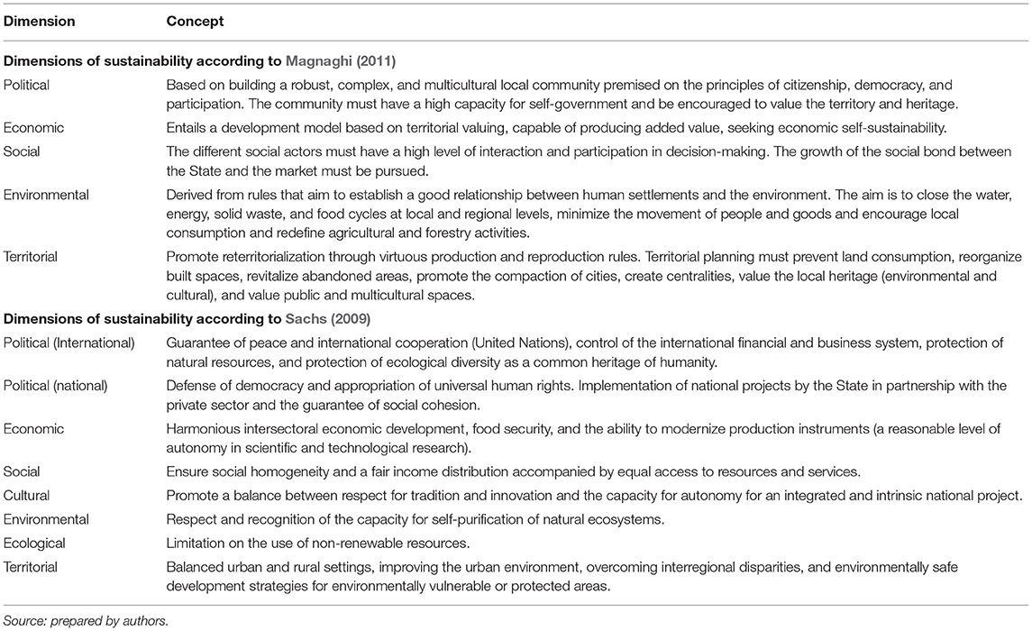
Table 1. Dimensions of sustainability according to Magnaghi (2011) and Sachs (2009).
The dimensions listed by Sachs (2009) and Magnaghi (2011) have several similarities and convergences. Although Sachs takes a broader perspective and Magnaghi a more applied approach to territorial planning, both authors view sustainability from a systemic and interdependent perspective. In this sense, “sustainability” is not seen as a mere environmental or sectoral issue, but as a relational problem with multiple dimensions.
Alvim (2003), corroborating with Magnaghi (1999), argues that redefining sustainability in the ambit of urban planning calls for the notion of territory as a living space for society and its pre-existences. The territorial approach seeks to address the problems surrounding territory with a multidisciplinary focus, considering environmental, territorial, cultural, and socioeconomic heritage in local dimensions through community empowerment.
When evaluating urban and environmental instruments in a water-producing region with rapid urban growth and marked socioeconomic inequalities, the valuing of the territory and the society residing within it based on democratic and citizenship practices should be considered determinants for the sustainability of these public policies.
The appreciation of the territory and its physical, environmental, and social pre-existence translates as an essential strategy to achieve sustainable development. This means that the quality of territorial production is an important indicator of ecological sustainability, since it is interpreted as a mixture of ecosystems. Territorialism approaches sustainability by focusing on the human environment (considering natural and built environments), thinking about sustainable development from the territory, understood as a neoecosystem produced by people, including the relations between culture, nature and history. From this integrated perspective, the territory's degradation has implications for multiple dimensions, promoting deterioration of natural, built and social aspects (Magnaghi, 2011; Alvim et al., 2019).
Rethinking the concept of sustainable development entails understanding and overcoming the dualistic view that divides the territory between areas with “economic” function and protected areas with “naturalistic” function. This involves a shift toward a systemic and integrated perspective, in which the whole territory (including the urban, built environment) is treated as a neoecosystem, seeking a concept of environmental, social, territorial, economic, and political sustainability (Alvim et al., 2019; Marques, 2019).
The sustainability concept that underpins the analysis in this article is aligned with this systemic vision and applied to territorial planning, aiming to construct sustainable territories. Despite recognizing the importance of each of the sustainability dimensions developed by the authors and their intersections, this article lists those elements that are potentially more adequate to support an analysis of urban and environmental legislation. The dimensions were listed according to major themes, seeking to pool elements (qualitative indicators) that corroborate an integrated analysis, namely, the political, socioeconomic, environmental and territorial dimensions.
In this systemic vision, it is understood that the construction of sustainable territories involves the incorporation of citizenship and participation principles in the planning and management process. In this sense, the political dimension of sustainability assumes a fundamental role because it must counter the culture of social polarization. Supported by democracy and participation, self-government and the strengthening of the local community should be encouraged, recognizing conflicts, complexity, peculiarities of the territories, allowing mediation and resolution of disputes, and collectively generating a future project for this society.
This type of organization does not extinguish the conflicting interests of the community. However, the mediation of its conflicts must be based on understanding and valuing collective interests over individual interests.
In this article, the social and economic dimensions will be addressed together. As outlined earlier, addressing the concept of sustainable development from a systemic approach is premised on understanding that environmental degradation is not a sectoral problem. Unsustainability is the product of a systematic process of man's distancing from his territory and an extractivism that generates socio-environmental injustices (Acselrad, 2004; Magnaghi, 2011). Therefore, when thinking about the construction of sustainable habitats, the socioeconomic dimension should be considered, toward promoting a low-carbon economy and just income distribution, allied with equal access to resources and services, based on the participation and balance of forces of various actors in society. Thus, it seeks to strengthen the social bond between the State, civil society, and the market, aiming to value the territory and create job opportunities and income generation for the local community.
Under a systemic view, the environmental dimension of sustainability should not be based on a corrective logic but aim at establishing a healthy relationship between human settlements and the environment. In this respect, it is fundamental to seek territories from low carbon matrices and encourage the closing of water, energy, solid waste and food cycles at local and regional levels (Sachs, 2009; Magnaghi, 2011). Given the goal of reducing pollutant emissions, the movement of people and goods should be minimized and local consumption encouraged. In this view, the environment is not interpreted as a mere source of economic support. There is an attempt to establish virtuous relationships between the natural environment, built environment, and distribution of activities/functions within the territory.
The territorial dimension aims to promote the local community's “reterritorialization” with its territory by establishing virtuous production and reproduction rules. The fragmented city, dispersed and organized as a function of supporting the economic activities of circulation, consumption and accumulation, must be remedied. Given the level of deforestation and environmental degradation, city planning must prevent land consumption, reorganize the spaces already built, recover abandoned areas and value local heritage (cultural and ecological) and public spaces. The built environment should be based on multi-center systems, replacing the center-periphery logic and creating balanced urban and rural relations.
The State Water Resources Policy and Integrated Approach
In the political-institutional panorama, the State of São Paulo has some peculiarities, especially with regard to water resource policies. Since 1991, before the 1997 National Policy on Hydrological Resources (Federal Law 9.433/1997), the State of São Paulo had enacted its State Policy for Water Resources (State Law 7.663/1991), providing for a decentralized, participative and integrated management system, adopting the hydrographic basin as the physical-territorial unit for planning and management (Alvim, 2003). The administrative structure defined in the Law comprised the State Council of Hydrological Resources, formed by the State Secretariats or their representatives; by representatives of the cities within the hydrographic basins, civil society and universities, and by the Hydrographic Basin Committees, which have the same tripartite structure. The Hydrological Resources Management Units (UGRHIs) of the State of São Paulo were derived from this landmark legislation.
In 1997, the new Law for the recovery and preservation of the springs of the State of São Paulo (State Law no. 9866) was implemented. This Law adopted a new planning and management model for the State's hydrographic basins, outlining the principles established by the State Policy for Hydrological Resources (State Law 7.663/1991) cited above. The new Law stipulated the devising of specific legislation for each springs area of regional importance in the State's hydrographic basins or sub-basins (São paulo, 1997).
Within the scope of the Upper Tietê Watershed, four specific laws were enacted between 2006 and 2016. These laws include State Law No. 15,790/2015, which defined the Area of Protection and Recovery of Springs—Alto Juquery (APRM-AJ), of the Juqueri-Cantareira sub-basin, which will be analyzed in this article. The specific legislation's approval required that the cities located within the spring preservation area make their Master Plans compatible with the guidelines set out in the Law and the new environmental zoning regulations of each sub-basin. However, to date, none of the Juqueri-Cantareira sub-basin cities that make up the APRM-AJ (State Law 15.790/2015) have made their Master Plans compatible with the Specific Law.
It is essential to highlight the impasses in coordination between Master Plans and specific laws to protect springs. Several authors (Saraiva, 1999; Muñoz, 2000; Alvim, 2003) consider the watershed a fundamental unit for planning and environmental management to ensure environmental quality, especially water resource availability. However, in Brazil, this territory is subordinated to planning and management processes that favor other sectoral logic and, therefore, it is a territory subject to disputes and conflicts (Alvim et al., 2008, 2015).
In the Brazilian case, following the precepts of the 1988 Federal Constitution, urban policy is the responsibility of the municipal authorities, and the Master Plan is the main instrument in urban development, and mandatory for cities with over 20,000 inhabitants (articles 182 and 183 of the Federal Constitution). At the regional level, Article 25 of the Federal Constitution stipulates that the States, through complementary Law, can establish metropolitan regions, urban agglomerations and micro-regions, composed of groups of neighboring cities, to integrate the organization, planning and execution of public functions of common interest. According to the constitution, environmental policies are the joint responsibility of the three federative entities (Union, States, Federal District, and Municipalities) that must promote the protection of the environment and water resources (article 20 of the Federal Constitution).
According to Alvim et al. (2008), although the Brazilian legislation governing environmental, urban and hydrological policies is considered advanced, the challenge of building paths that equate the main conflicts to render this integration feasible prevails. The integration of principles with a view to promoting sustainability in a given territory depends on effective articulation with other policies that affect it, i.e., a negotiated process between government bodies, institutional sectors and players that arbitrate conflicts and multiple interfaces.
Context: The Juqueri-Cantareira Sub-Basin
The empirical focus of the present article, the Juqueri-Cantareira sub-basin, is a hydrological sub-region comprising the Upper Tietê Hydrographic Basin (UGRHI-6) and is situated in the northern portion of the São Paulo Metropolitan Region, covering part of the city of São Paulo, principally the districts of Anhanguera, Jaraguá and Perus, and the smaller cities of Caieiras, Cajamar, Franco da Rocha, Francisco Morato, and Mairiporã, as shown in Figure 1.
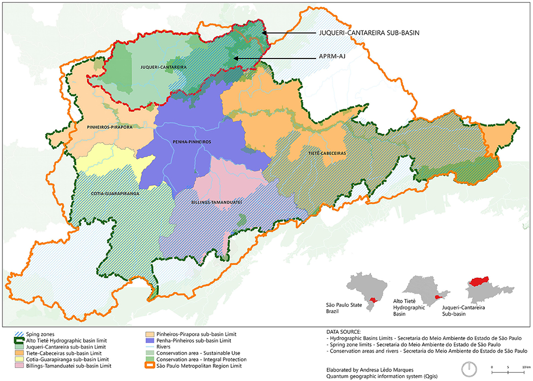
Figure 1. Hydrographic sub-basins of the Alto Tietê Hydrographic Basin highlighting the Juqueri-Cantareira Sub-basin. Data source: São Paulo State Secretariat for the Environment. Available at: http://datageo.ambiente.sp.gov.br. Accessed: July 2018. Produced by: Andresa Ledo Marques.
This sub-basin is located in an area of very uneven topography and encompasses significant natural remnants on a metropolitan scale, such as state parks and environmental protection areas, which are part of the São Paulo Green Belt Biosphere Reserve (Instituto de Pesquisas Tecnológicas do Estado de São Paulo, 2008, p. 52). Besides the ecological heritage, the region also has a very relevant historical heritage. Figure 2 illustrates the listed sites protected by the Council for the Defense of Historical, Archeological, Art, and Tourist Heritage (CONDEPHAAT). These sites constitute an extensive group of important works, which tell part of the State's history and that of the Metropolitan Region of São Paulo. Many of these sites are linked to the railroad or the industrial development period of the cities.
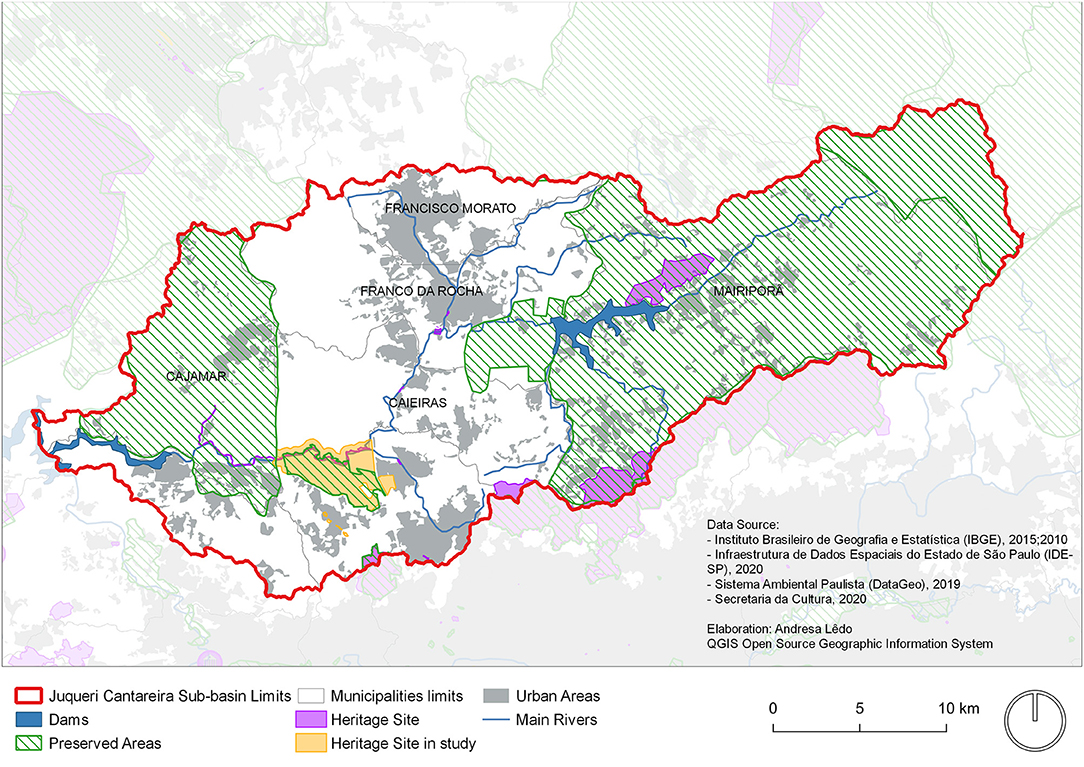
Figure 2. Juqueri-Cantareira Sub-basin: APRM-AJ, heritage sites and those under consideration by CONDEPHAAT and environmental preservation areas. Data source: São Paulo State Secretariat for the Environment and EMPLASA. Available at: http://datageo.ambiente.sp.gov.br. Accessed: December 2018. Produced by: Andresa Ledo Marques.
The sub-basin is home to 848,593 inhabitants (IBGE, 2010) and has undergone significant population growth. The average population growth rate of the Juqueri-Cantareira sub-basin between 2000 and 2010 was 2.60% per year. In the same period, the average for São Paulo city was 0.76% per year and 0.97% per year for the metropolitan region. The cities of Mairiporã (3.04%), Cajamar (2.36%), and Caieiras (2.01%) stand out with the highest rates, besides the districts of Jaraguá (2.39%) and Anhanguera (2.6%), located in the extreme north of São Paulo city. This migratory population movement causes population pressure which, if not adequately tackled and controlled by integrated inclusive public policies—Urban and Environmental—can lead to a disastrous scenario, especially from an environmental perspective.
As defined by the IBGE, the precarious settlements, or Subnormal Agglomerations, have been expanding in the region, especially in the cities of Franco da Rocha and Francisco Morato and in the districts of Perus, Anhanguera, and Jaraguá. The amount of settlements in Risk areas is alarming, especially those located in Francisco Morato and the central region of Mairiporã, near the Paiva Castro reservoir, as evident in Figure 3 based on georeferenced data from IBGE.
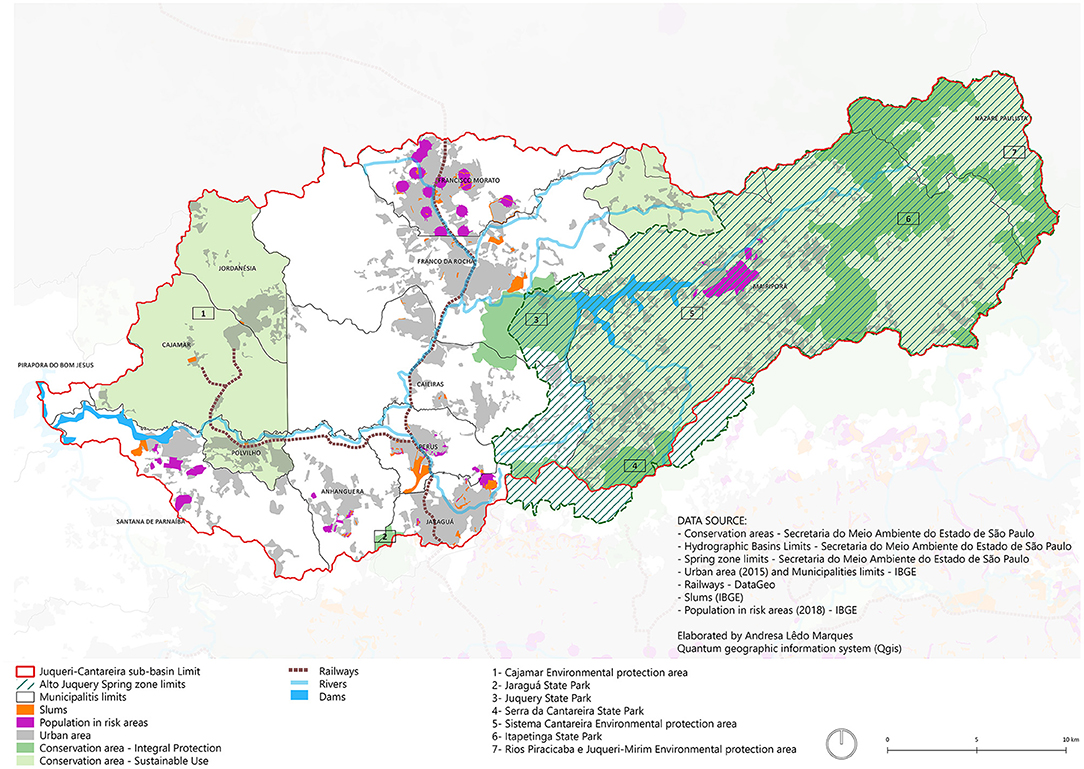
Figure 3. Juqueri-Cantareira Sub-basin: APRM-AJ, urbanized areas, subnormal agglomerates (slums), and population at risk. Data source: São Paulo State Secretariat for the Environment, EMPLASA, and DataGEO. Available at: http://datageo.ambiente.sp.gov.br. Accessed: July 2018. Produced by: Andresa Ledo Marques.
With regard to social vulnerability, georeferenced data for the São Paulo Social Vulnerability Index (spatialized in Figure 4) shows that the areas corresponding to vulnerability grades 6 and 7 (high vulnerability) correspond to the outskirts of Mairiporã (within the protected springs area), and the outskirts of Franco da Rocha and Francisco Morato. The areas rated as grade 1, with very low vulnerability, correspond to high standard condominiums. The most vulnerable municipalities in the sub-basin are Francisco Morato, Franco da Rocha and Cajamar because a significant part of their territory is rated as medium and high vulnerability. The other districts and cities have high/medium vulnerability, where most of this territory has a low degree of social vulnerability.
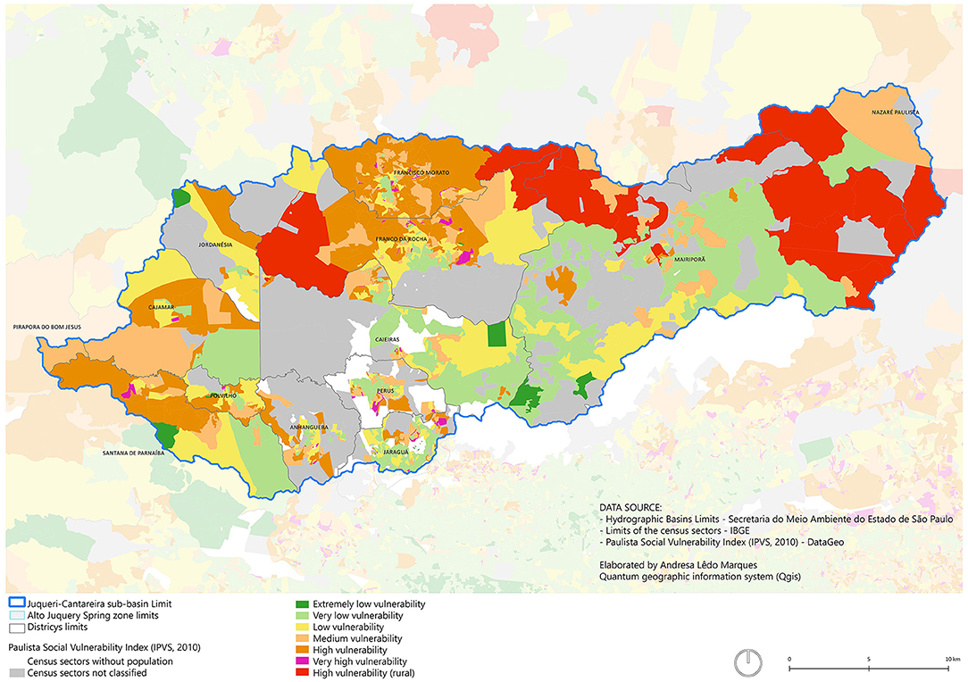
Figure 4. Juqueri-Cantareira sub-basin—São Paulo social vulnerability index, 2010. Source: Fundação Seade (2013) and IBGE. Produced by: Andresa Lêdo Marques.
The synthesis of some data from this sub-region, although not reflecting the full Construction of sustainable territories and the multiple dimensions of sustainability complexity of its problems, help highlight the central issues that should be dealt with in an articulated manner by the set of urban and environmental planning instruments proposed, within the overarching perspective of sustainability of the territory. Subsequently, albeit briefly, an evaluation is provided of the main urban and environmental planning instruments in effect within the region, along with the Master Plans of the cities of Caieiras, Franco da Rocha and Mairiporã, and the Specific Law of the Alto Juquery Springs Protection and Recovery Area (APRM-AJ).
Materials and Methods
The Multiple Dimensions of Sustainability
The premise that sustainability has multiple dimensions is based on the theories of Sachs (2009) and Magnaghi (1999, 2011), as summarized in the previous section. Both scholars argue that sustainability is systemic and complex, recognizing the complexity of the discussion on sustainable development and providing contributions that go beyond the classic tripartite of sustainability of social, economic and environmental dimensions. These authors extended the concept by also incorporating cultural, territorial, and political aspects.
In the study of Marques (2019), a qualitative evaluation matrix was built for the analysis of Master Plans and Specific Legislation derived from articulation of the dimensions addressed by Sachs (2009) and Magnaghi (1999, 2011). The sustainability dimensions elected were: political, environmental, territorial, and socioeconomic (Figure 5). From these dimensions, elements (Table 2) of analysis were listed based on the literature review that correspond to each group and tare compatible with the study of urban and environmental policy, as follows:
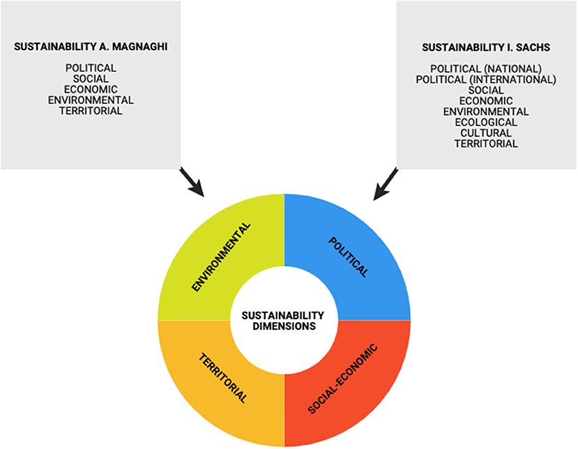
Figure 5. Diagram depicting articulation of sustainability dimensions of Sachs (2009) and Magnaghi (2011).
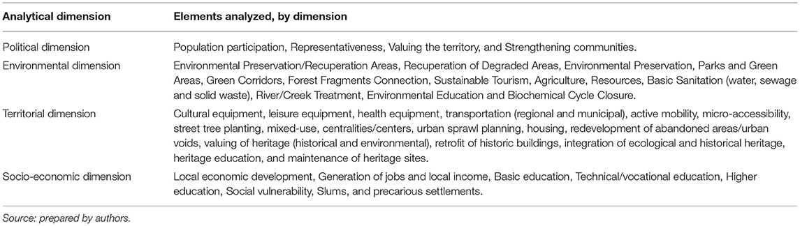
Table 2. Summary evaluation matrix containing elements analyzed, by sustainability dimension.
Political Dimension
Political dimension involves the degree of participation in decision-making, representativeness of different groups of society (including those historically marginalized), valuing and strengthening of the local community. The following components were listed for instrument analysis: participation of the population, representativeness, valuing the territory and strengthening the communities.
Environmental Dimension
Environmental dimension evaluates how strategies established in the analyzed legislation have considered the components of environmental science, especially ecology, in its scope, while addressing environmental recovery/protection and balance of ecosystems. The following elements were considered in the analysis: Environmental Preservation/Recuperation Areas, Recuperation of Degraded Areas, Environmental Preservation, Parks and Green Areas, Green Corridors, Forest Fragments Connection, Sustainable Tourism, Agriculture, Resources, Basic Sanitation (water, sewage and solid waste), River/Creek Treatment, Environmental Education, and Biochemical Cycle Closure.
Territorial Dimension
Territorial dimension aims to understand what strategies the Municipal Master Plans and the Specific Law have devised to establish a balance between the natural and built environments, between society and nature, and to promote reterritorialization of the local community into its territory. To this end, the following components are analyzed: cultural equipment, leisure equipment, health equipment, transportation (regional and municipal), active mobility, micro-accessibility, street tree planting, mixed-use, centralities/centers, urban sprawl planning, housing, redevelopment of abandoned areas/urban voids, valuing of heritage (historical and environmental), retrofit of historic buildings, integration of ecological and historical heritage, heritage education, and maintenance of heritage sites.
Socioeconomic Dimension
Socioeconomic dimension deals with fundamental components to the population's socioeconomic dynamics, seeking to understand how the urban and environmental instruments solve or mitigate the main social and economic problems of the region, aimed at promoting its sustainable development. The proposed analysis components are: local economic development, Generation of jobs and local income, Basic education, Technical/vocational education, Higher education, Social vulnerability, Slums, and precarious settlements.
Study Period and Empirical Context
The present article reports the analysis of the Master Plans of the cities of Caieiras, Franco da Rocha and Mairiporã, carried out between 2005 and 2018. These cities are located on the outskirts of the São Paulo Metropolitan Region, more specifically in the Juqueri-Cantareira sub-basin, and were selected according to the following criteria:
• Small cities relative to São Paulo city and, therefore, with a lower degree of complexity in terms of urban and environmental policies;
• Cities that have undergone marked population growth to the detriment of preserved areas;
• Cities situated within the Area of Protection and Recovery of Springs—Alto Juquery, since the environmental issue, such as water production, among other ecosystem services, are central to this study.
The list of cities located within the Juqueri-Cantareira sub-basin and their respective percentage of the catchment area is given in Table 3. Mairiporã has 80% of its territory within the APRM-AJ, Caieiras has 20%, Franco da Rocha 5% and São Paulo 1.5%. The Master Plan of São Paulo will not be discussed in this article because the study objective was to address cities that lie fully within the fringe area.
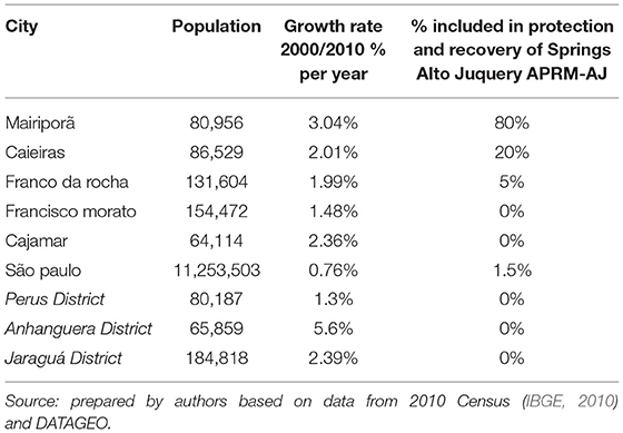
Table 3. List of cities with areas within Juqueri-Cantareira sub-basin.
Considering the criteria listed above, the strategies/guidelines of the following urban and environmental instruments were analyzed:
• Mairiporã Master Plan: Complementary Law No. 297/2006 (Mairiporã, 2006)
• Caieiras Master Plan: Supplementary Law No. 4538/2012 (Caieiras, 2012)
• Franco da Rocha Master Plan: Supplementary Law No. 618/2007 and amendments contained in Supplementary Law No. 244/2015 (Franco Da Rocha, 2007, 2015)
• Specific Law for the Protection and Recovery Area of Alto Juquery Springs—APRM-AJ: Law 15.790/2015 (São paulo, 2015)
Data Collection
The qualitative analyses of the instruments listed according to the criteria set out in the previous item were performed based on the four dimensions of sustainability, namely: the political dimension, socioeconomic dimension, environmental dimension and the territorial dimension. These dimensions of analysis were established from the articulation of the sustainability dimensions devised by Magnaghi (2011) and Sachs (2009), as noted in the theoretical framework. From these dimensions, elements of analysis were listed that correspond to each dimension and were compatible with the study of urban and environmental policy.
The matrix was completed with information gathered from the reading and analytical transcription of the articles of the Master Plans and Specific Legislation corresponding to each element in the evaluation matrix. After filling out the matrix and comparing the laws, a synthesis of each instrument's strategies was produced outlining the dimensions of sustainability addressed. Finally, to aid comparison of the instruments analyzed, scales (grades) were assigned to measure the elements making up each dimension, as follows:
• 0 = no guideline/strategy in the instrument addressed the element of analysis;
• 1 = the element of analysis was addressed in a minimal and/or superficial way;
• 2 = the element of analysis was addressed partially or not satisfactorily;
• 3 = the element of analysis was addressed in depth.
This stage, considered exploratory, provided the basis of a comparative and relativized analysis of the cases addressed. The results obtained for each dimension were systematized into a matrix. The general grades assigned are based on the overall average of the elements analyzed. This average will be presented in a comparative Wheel Chart graph in the ensuing section.
Results
Figure 6 depicts a comparative Wheel Chart graph of all the instruments analyzed according to the criteria and scales detailed in the previous item. Although the legislation provides for some elements of the sustainability dimensions, there are still a series of shortcomings in promoting the construction of more just sustainable cities. Indeed, some elements actually induce the processes of sprawl, monofunctional, and extractive urbanization.
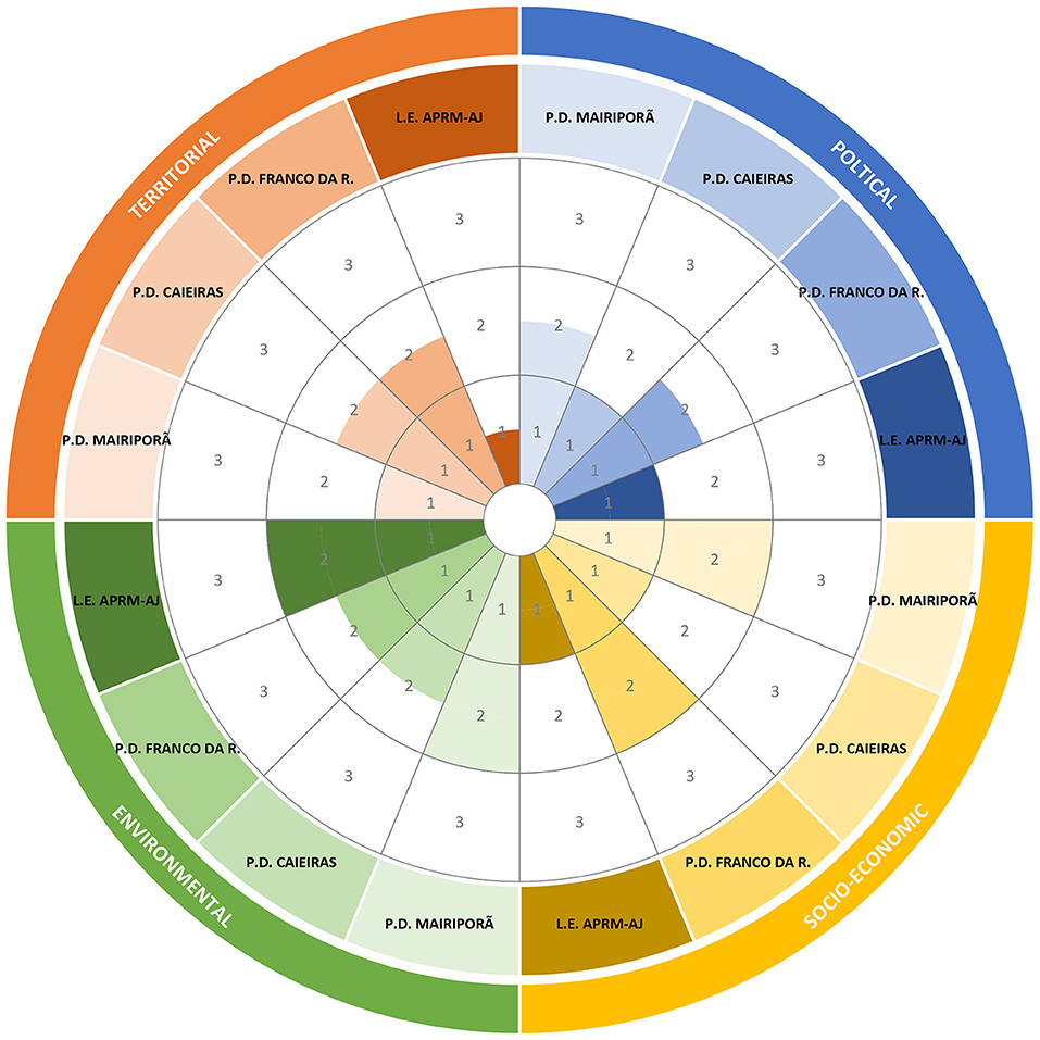
Figure 6. Comparative wheel chart graph illustrating instruments analyzed and degree to which they address each sustainability dimension. PD, master plan; LE, specific law.
Although the legislation cites the concept of “sustainability,” this concept should be addressed in an integrated way, allowing it to permeate several dimensions of urban and environmental policy and more effectively address today's dynamics and complexities.
The Political and Territorial dimensions attained the lowest overall averages among the instruments. This was due to the fact that they did not consider, or considered very superficially, issues related to the representativeness of different social groups in the process of planning and management of the territories and the strengthening of local communities, with regard to the political aspects. Other shortcomings included a lack of guidelines aimed at containing the sprawl of the urban area, redevelopment of urban voids, compacting of cities, active mobility and the integration of both environmental and historical heritage.
The socioeconomic dimension was better developed in the Mairiporã and Franco da Rocha plans, both addressing a series of elements in favor of local economic development and dealing with the social vulnerabilities present in the cities. Franco da Rocha stood out for emphasizing education at different levels (primary, vocational and higher education) in its plan. Caieiras, on the other hand, failed to meaningfully address the issue of higher education or tackling social vulnerability. The Specific Law did not address elements related to education and social vulnerability.
The elements of the Environmental dimension were, in general, well-provided for by the legislations, especially in the case of the Specific Law and Caieiras Master Plan. The most neglected aspect in the analysis in all cases was the intention of closing the water, energy, solid waste, and food cycles at local and regional levels; this issue did not feature in any of the instruments.
Discussion
Taken together, the results reveal the limits and advances of the urban and environmental instruments analyzed, especially the Master Plans and the Specific Law for Protection and Recovery of Springs. We pose questions about paths for a planning process favoring the sustainability of the region in its multiple dimensions. Is it possible to devise a planning process that reconciles local community needs, economic development, and the preservation of a territory rich in environmental and historical heritage? What is the vision of “sustainability” addressed by the instruments?
The Political Dimension
The Political Dimension was less prominent in all cases, especially for aspects related to the representation of different groups of society in the planning process and management of territories. Although the legislation analyzed cites population participation in the planning process, in accordance with the precepts established by the Federal Constitution of 1988 and by the City Statute, this issue remains a major challenge for the cities assessed.
Multicultural representation featured only superficially in the instruments analyzed. This reveals a certain weakness of the legislation in promoting the strengthening and valuing of the local community, in building a solid and aware community capable of valuing the local territorial and environmental heritage and promoting its self-sustainability. It is important to emphasize that the weakening of the political dimension systematically jeopardizes the commitment and effectiveness of the other dimensions of sustainability, since society's participation and engagement are central elements to implementing a more sustainable development model. How can sustainable territories be built without the effective participation and engagement of local communities?
Despite the weakness of the political dimension, some strategies present in the plans—albeit incipient—seem to indicate the beginning of a process of valuing this dimension. Mairiporã's Master plan establishes procedures that promote the valuing of local community and territorial goals, recognizing the need to strengthen the economic bases identified as a city goal. Another example is the Franco da Rocha Master Plan that outlines the importance of creating a municipal memory and cultural identity and appropriation of public spaces by residents.
The Environmental Dimension
Specific Law 15.790/2015 was the legislation which best addressed the environmental issue among all the other legislations analyzed. The Law provides for the creation of several areas for preservation, leisure, tourism, recreation, and valuing of the scenic-landscape attributes of the region and areas for environmental recovery and protection. Several strategies stand out in the Specific Law, such as the creation of incentive, support, and advisory programs for the ecological management of the land, sustainable use of agriculture and non-impacting rural activities in Low-Density Sub-Areas (SBD) and the reduction of the effects of diffuse pollution: use of appropriate agricultural management practices, prioritizing organic agriculture and bans on the use of biocides.
Mairiporã stands out among the Municipal Plans by addressing local agriculture, which is not destined only to a small portion of the territory, as is the case of Caieiras. The Mairiporã Master Plan states the importance of reviving local agricultural farming and creating stimulus programs for sustainable agricultural activities, offering technical support to local producers so that they can adequately manage the land.
Regarding regional planning, the Inter-Municipal Consortium of Municipalities of the Juquery Basin (CIMBAJU) played a key role in incorporating urban-environmental planning strategies on the sub-basin scale, i.e., on the regional scale. Because of the committee's action, Caieiras and Franco da Rocha's plans include the implementation of a linear park along the embankments of the Linha 7 Rubi railroad, which would form a large regional park. In the same vein, the city of Caieiras furthered this with a system of parks and green areas that permeates the whole municipal territory, connecting large environmental preservation areas, the Cajamar Environmental Protection Area and the Environmental Protection Area of the Cantareira system.
None of the instruments analyzed addressed the closing of the water, energy, solid waste and food cycles at local and regional levels. In general, consistent with the precepts of the Brazilian legal framework, the scope of the instruments included the universal provision of basic sanitation, the creation of environmental education programs and actions for preservation ecological recuperation, with an emphasis on protected areas. Although the Master Plans analyzed, up to the time of data treatment, had not yet been made compatible with the Specific Law, all recognized the importance of the water catchment areas' metropolitan nature and defined protection strategies for them.
In this sense, the defining of areas of regional importance under the State Water Resources Policy led to the creation of preservation strategies for these areas. However, the cities still have an extractive vision for the areas not yet occupied and unprotected by Law.
The Territorial Dimension
In the instruments analyzed, actions concerning the territory were more linked to environmental and urban aspects and failed to address socioeconomic and political issues. A development perspective based on traditional industries, highways and urban sprawl predominated in the Master Plans.
The highway model still plays a central role in the territorial planning strategies concerning municipal and regional transport. Road widening and plans for new highways and viaducts were common, to the detriment of encouraging quality public transportation, among other modes with less environmental impact. The issue of active mobility (bike lanes, sidewalks, pedestrian walkways) was addressed only in the Caieiras and Franco da Rocha Plans.
An advance is a fact that all the Master Plans cite the importance of integrating (in terms of fares and physically) of metropolitan transportation, proposing articulations with the State Government and transportation companies. This is a central point for improving public transport in the São Paulo Metropolitan Region, since there is fare integration is only available for trains and buses, which come under State Government jurisdiction with no integration for municipal transportation. This issue makes it more expensive and difficult for the population to access public transport.
Except for Mairiporã, the Master Plans analyzed did not value local development and still promoted urban sprawl and fragmentation of the city. This can be exemplified by the case of Caieiras, which has no mixed zones in its zoning regulations, only a few areas of diversified use, reaffirming the fragmented city logic. All the commercial use zones of the city are located along the main highways. The urban expansion areas head toward the Cajamar Environmental Preservation Area, with predominantly residential and industrial uses. Figure 7 clearly shows the large number of predominantly residential zones compared to other uses.
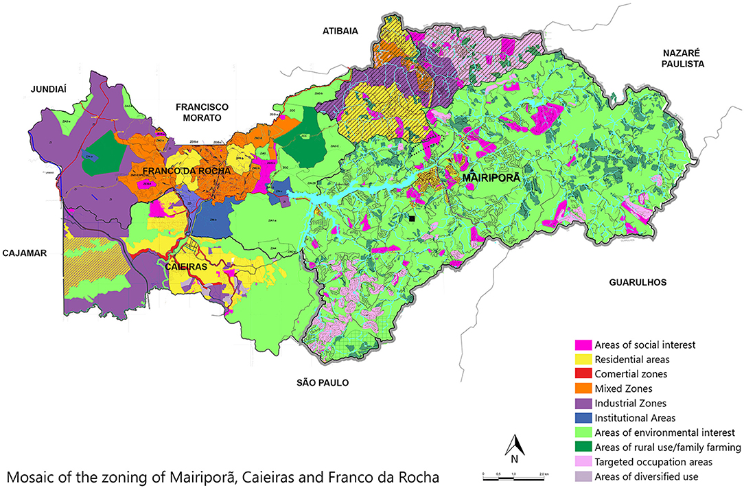
Figure 7. Mosaic of municipal Zoning of Mairiporã, Caieiras, and Franco da Rocha. Data source: municipal authority of cities of Mairiporã, Caieiras and Franco da Rocha. Produced by: Andresa Lêdo Marques.
It can be noted that Caieiras and Franco da Rocha, in particular, consider the eastern region (toward Cajamar) as an urban expansion vector, encouraging urban sprawl in this region, with industrial and residential uses. It should be highlighted that the Caieiras Master Plan establishes a Special Zone of Metropolitan Interest (ZEIM 1 and 2) for this region, in which a forestry area is currently located. The plan defines this area for high and medium population density residential use or structuring projects of metropolitan scope and interest. There is a project commissioned by the Companhia de Concessões de Rodovias (CCR) to build the New São Paulo Airport in this area.
The Socioeconomic Dimension
With regard to the socioeconomic dimension, the strategies adopted did not focus on the sustainable development of the region or on a vision of economic self-sustainability that considers regional aspects or activities potentially appropriate for a water-producing region, with a historical and environmental heritage of great importance.
The Franco da Rocha and Caieiras Plans present employment and income generation strategies centered on industrial development (potentially polluting or otherwise), attributing to the cities the same vision and strategy of economic “development” implemented in other areas of the Metropolitan Region, such as the ABC Paulista, with no emphasis on low-carbon and ecological, economic activities.
In general, the cities promoted strategies aimed at local development and valuing of the environmental heritage only in Spring areas; ecological processes were not an integral part of the city planning. The case of Caieiras exemplifies this issue by encouraging sustainable tourism activities as an alternative to economic development that generates employment and income only in a small part of the city consisting of the water springs area protected by State law. Other areas endowed with significant natural remnants are destined for industrial development.
The Mairiporã Master Plan is noteworthy for containing economic guidelines focused on the territory's environmental goals, emphasizing sustainable tourism, the implementation of low impact and high added value industries, sustainable agricultural activities and cooperatives as forms of employment and income generation.
Regarding the aspects related to education, all the plans analyzed cited the implementation of new school units to meet municipal demand and the creation of technical schools. However, only Franco da Rocha outlined the implementation of a University Campus for Higher Education, which was not mentioned as a priority for the other cities.
Regarding the strategies aimed at precarious settlements, slums and areas with high social vulnerability, the Master Plans and Specific Law emphasized the importance of ensuring the social function of property and decent housing and promoting land regularization, urbanization projects, and removal of the population from high risk areas and basic sanitation. However, some strategies stand out. For example, the Master Plan of Mairiporã adopts the neighborhood or census sector scale as the territorial unit of reference for the implementation of social welfare policies. In addition, the plan includes the promotion of self-defense practices and environmental education for risk management.
Actionable Recommendations
The urban and environmental instruments analyzed in this article focus on a complex territory that is home to critical natural remnants and protected areas, while marked by profound social and economic asymmetries and pressured by different demands and actors. The analysis shed light on the advances and challenges of integrating urban and environmental policies, albeit in a limited fashion. Application of the methodology showed that, although the Municipal and State Urban Policy touches on the dimensions of sustainability, there are still many flawed and superficial approaches. The main shortcomings that appeared recurrently in the instruments are described below, together with recommendations.
Effective Integration Between Public Policies
Although the State Policy framework stipulates compatibility of municipal Master Plans with the Specific Law for Protection and Recovery of Springs, this proved not to be the case for the plans analyzed. This process is not address in an integrated way, and the timing of the legislations differs. Moreover, in the Brazilian reality, the smaller cities often do not have technical experts available to carry out the compatibility process with the competent state organ.
This lack of compatibility creates a series of obstacles for the cities, which depend on the state agency for environmental licensing, involving a series of extensive and bureaucratic processes that, coupled with the lack of inspection in these areas, often leads to a devaluing of the importance of watershed areas and irregular occupation of these areas.
The public policies designed for these essential natural remnants should yield benefits for the population in different spheres. To this end, it is necessary to carefully examine the territory, considering its features and particularities, involving other agents in the process. The State and Cites must work together to safeguard the preservation of areas that provide important environmental services and have a systemic impact on a network of cities connected in different dimensions. Thus, there is a pressing need for convergences and synergies regarding natural resource sustainability and sustainable development of the region analyzed.
The Production of Fragmented Constantly Expanding Cities Must Be Overcome
Except for the Specific Law, a vision of development based on industries, highways and urban sprawl prevailed in the Master Plans. The Plans reaffirm the logic of the fragmented constantly expanding city organized to support economic activities, circulation of people and goods, consumption and accumulation. The cities analyzed must radically change this vision of planning and devise strategies that prevent urban sprawl and promote reorganization of existing built areas, reduction of movement of people and goods and incentives for local consumption.
Establishing a planning process based on an integrated vision aimed at sustainability calls for multidisciplinary efforts and a cultural shift, which is at the same time complex and involves multiple authors. The region's problems must be tackled and the value of its environmental potential and local communities appreciated, incorporating the various dimensions of sustainability in its territorial management from a systemic vision of integrated planning embracing urban and environmental aspects at municipal and regional levels.
Sustainability Should Not Be Regarded as a Sectoral Problem
As discussed in the theoretical framework, it is argued here that the construction of sustainable territories requires a systemic vision that considers not only environmental aspects but also social, economic, cultural and territorial aspects. However, in the policies analyzed, sustainability is still regarded as a sectoral, merely environmental problem, as if the preservation and recuperation of a small proportion of natural remnants were enough to construct “sustainable cities.” Effective participation of different actors, valuing of the community, and environmental awareness of the structural changes needed to build fairer and more sustainable cities are lacking.
Without the construction of a solid and aware local community, it is impossible to value the local heritage with access to education and job opportunities or to promote the construction of sustainable territories. Furthermore, incentives in different areas are necessary to reduce pollutant emissions, change the energy matrix, and close the water, energy, solid waste, and food cycles at local and regional levels.
Conclusions
The analysis presented sought to discuss how the Specific Law for Preservation and Recovery of Springs—Alto Juquery (APRM-AJ) and the Master Plans of the cities within a section of the Juqueri-Cantareira sub-basin have proposed actions and guidelines for sustainable development of this region in the formulation of their respective legislation.
The results show that the vision of “sustainability” contained in the urban and environmental instruments analyzed has a sectoral perspective and fails to address its various dimensions in urban and environmental policies. In general, the political and territorial dimensions were overlooked in the scope of the instruments. However, the construction of a participative process of effective planning and management prevails. The vision of city production focused on land consumption that prioritizes the economic dimension to the detriment of social and environmental aspects.
Citing the environmental protection of a small portion of natural remnants does not mean building sustainable cities. Clear strategies are needed that do not focus solely on the recovery and/or protection of a particular area, but aim to integrate social, economic, environmental, territorial and political aspects into the planning process based on citizenship principles.
Cities and State government should embrace sustainability, incorporating its multiple dimensions into territorial management adopting a systemic vision of integrated planning that involves urban and environmental aspects and municipal and regional levels. Sustainable and innovative alternatives should be explored for the region, to promote sustainable territories capable of providing employment and income generation, quality of life, and a balanced environment for this region and for future generations.
Author Contributions
ALM and AA conceptualized the study and performed the data analysis presented in the paper. The manuscript was written by ALM and reviewed by AA. ALM produced the maps and tables. Both authors were involved in collecting data and discussing the results and methods presented in the manuscript.
Funding
The work was funded by CAPES-PROEX (Coordenação de Aperfeiçoamento de Pessoal de Nível Superior—Programa de Excelência Acadêmica) Processo no. 88887.198452/2018-00 e Processo no. 88887.502738/2020-00, CAPES-PRINT Processo no. 745884P, and CNPq (Conselho Nacional de Desenvolvimento Científico e Tecnológico) Process 23038.009799/2019-96 CAPES/PROEX, Project 1135/2019.
Conflict of Interest
The authors declare that the research was conducted in the absence of any commercial or financial relationships that could be construed as a potential conflict of interest.
Acknowledgments
The authors are grateful to the colleagues from the Faculty of Architecture and Urbanism of Mackenzie Presbyterian University for all the exchange of knowledge and experience, especially the research group Projects for the Urbanization of Precarious Settlements and Environmental Protection Areas: the Dimensions of Sustainability. Thanks are also extended to the following bodies and professionals who contributed to the development of this work: Coordenação de Aperfeiçoamento de Pessoal de Nivel Superior (CAPES), Secretariat of the Environment of the municipalities of Caieiras and Mairiporã, Secretariat of Infrastructure and Environment of the State of São Paulo, EMPLASA, Bonfílio Alves Ferreira, and Prof. Francisco José de Toledo Pizza.
Footnotes
1. ^Master's dissertation authored by Andresa Lêdo Marques under the supervision of Prof. Dr. Angélica Benatti Alvim entitled “Franjas metropolitanas e as dimensões da sustentabilidade: o caso da sub-bacia Juqueri-Cantareira da Região Metropolitana de São Paulo.”
References
Acselrad, H. (2004). “Justiça Ambiental: ação coletiva e estratégias argumentativas,” in Justiça Ambiental e Cidadania, eds A. Henri, H. Selene, and P. José Augusto (Rio de Janeiro: Relume Dumará; Fundação Ford), 23–40.
Acselrad, H. (2007). Vigiar e unir: a agenda da sustentabilidade urbana? Revista VeraCidade 2, 1–11. Available online at: http://anais.anpur.org.br/index.php/anaisenanpur/article/view/624/611 (accessed February 01, 2021).
Alvim, A., Marques, A., and Alves, K. (2018). “Urbanização e Meio Ambiente no Contexto das Franjas Metropolitanas de São Paulo: O Caso Das Sub-bacias Juqueri-cantareira e Billings,” in V Encontro da Associação Nacional de Pesquisa e Pós-Graduação em Arquitetura e Urbanismo – ANAIS (Salvador: FAUFBA), 7889–7922. Available online at: https://repositorio.ufba.br/ri/handle/ri/27744 (accessed February 01, 2021).
Alvim, A., Rubio, V. M., Castro, L. G., Castro, A., Bruna, G. C., Brocaneli, P. F., et al. (2019). Assentamentos precários em áreas vulneráveis na Região Metropolitana de São Paulo: as dimensões da sustentabilidade nas intervenções para urbanização. Relatório final de pesquisa. São Paulo: Universidade Presbiteriana Mackenzie, Fundo Mackpesquisa.
Alvim, A. T. B. (2003). A contribuição do Comitê do Alto do Tietê à gestão da bacia metropolitana entre 1994 e 2001. Tese de Doutorado em Estruturas Ambientais e Urbanas pela Faculdade de Arquitetura e Urbanismo da Universidade de São Paulo.
Alvim, A. T. B., Bruna, G. C., and Kato, V. R. C. (2008). Políticas ambientais e urbanas em áreas de mananciais: interfaces e conflitos. Cad. Metrópole 1, 143–164. Available online at: http://www.veracidade.salvador.ba.gov.br/v2/index.php?option=com_content&view=article&id=21&Itemid=3 (accessed February 01, 2021).
Alvim, A. T. B., Kato, V., and Rosin, J. (2015). A urgência das águas: intervenções urbanas em Áreas de Mananciais. Cadernos Metrópole 17, 83–107. doi: 10.1590/2236-9996.2015-3304
Bellen, H. (2007). Indicadores de sustentabilidade: uma análise comparativa, 2nd Edn. Rio de Janeiro: Editora FGV.
Caieiras (2012). Lei Complementar n° 4538 DE 23 DE MARÇO DE 2012. Available online at: https://leismunicipais.com.br/plano-diretor-caieiras-sp (accessed February 01, 2021).
Franco Da Rocha (2007). Lei Complementar 618/2007. Available online at: http://www.francodarocha.sp.gov.br/franco/servico/leipdf/7081 (accessed February 01, 2021).
Franco Da Rocha (2015). Lei Complementar 244/2015. Available online at: http://www.francodarocha.sp.gov.br/franco/servico/leipdf/7270 (accessed February 01, 2021).
Fundação Seade (2013). Índice Paulista de Vulnerabilidade Social. São Paulo: Fundação Seade. Available online at: http://ipvs.seade.gov.br/view/index.php (accessed July 1, 2019).
IBGE (2010). Censo Demográfico 2010. Available online at: https://www.ibge.gov.br/geociencias/downloads-geociencias.html (accessed February 01, 2021).
Instituto de Pesquisas Tecnológicas do Estado de São Paulo (2008). Plano de Desenvolvimento e Proteção Ambiental da Sub-bacia do Juquery-Cantareira. São Paulo: Instituto de Pesquisas Tecnológicas do Estado de São Paulo.
Magnaghi, A. (1999). “Territorial heritage: a genetic code for sustainable development,” in Possible Urban Worlds: Urban Strategies at the End of the 20th Century, eds R. Wolff, A. Schneider, C. Schmid, P. Klaus, A. Hofer, and H. Hitz (Zurich: INURA), 114–21.
Magnaghi, A. (2011). El proyecto local: hacia uma conciencia del lugar (1a ed. en Arquitectonics). Barcelona, España: Universitat Politècnica de Catalunya.
Mairiporã (2006). LEI COMPLEMENTAR N° 297/2006. Available online at: https://leismunicipais.com.br/plano-diretor-mairipora-sp (accessed February 01, 2021).
Marques, A. L. (2019). Franjas metropolitanas e as dimensões da sustentabilidade: o caso da sub-bacia Juqueri-Cantareira da região metropolitana de São Paulo (dissertation/master). Universidade Presbiteriana Mackenzie, São Paulo (SP), Mestrado, Brazil: Available online at: http://tede.mackenzie.br/jspui/handle/tede/4079
Muñoz, H. R. (2000). Interfaces da Gestão dos Recursos Hídricos: Desafios da Lei deÁguas. Brasília: MMA/SRH.
São paulo (1997). Lei n° 9.866, de 28 de novembro de 1997. Available online at: https://www.al.sp.gov.br/repositorio/legislacao/lei/1997/lei-9866-28.11.1997.html (accessed February 01, 2021).
São paulo (2015). Lei n° 15.790, de 16 de abril de 2015. Available online at: https://www.al.sp.gov.br/repositorio/legislacao/lei/2015/lei-15790-16.04.2015.html#:~:text=Disp%C3%B5e%20sobre%20os%20limites%20da,AJ%20e%20d%C3%A1%20provid%C3%AAncias%20correlatas (accessed February 01, 2021).
Saraiva, M. (1999). O rio como paisagem – gestão de corredores fluviais no quadro do ordenamento do território. Lisboa, Fundação Calouste Gulbenkian.
UN Habitat (2016). Urbanization and Development: Emerging Futures. Available online at: http://wcr.unhabitat.org/wp-content/uploads/2017/02/WCR-2016-Full-Report.pdf (accessed March 01, 2021).
Keywords: sustainable development, sustainability dimensions, urban instruments, environmental instruments, spring protection zones, Juqueri-Cantareira sub-basin
Citation: Marques AL and Alvim ATB (2021) Construction of Sustainable Territories and the Multiple Dimensions of Sustainability: An Assessment of Urban and Environmental Instruments in the Juqueri-Cantareira Sub-basin of the São Paulo Metropolitan Region. Front. Sustain. Cities 3:670985. doi: 10.3389/frsc.2021.670985
Received: 22 February 2021; Accepted: 13 April 2021;
Published: 20 May 2021.
Edited by:
Pedro Roberto Jacobi, University of São Paulo, BrazilReviewed by:
Maria Lucia Refinetti Martins, University of São Paulo, BrazilTenley M. Conway, University of Toronto Mississauga, Canada
Copyright © 2021 Marques and Alvim. This is an open-access article distributed under the terms of the Creative Commons Attribution License (CC BY). The use, distribution or reproduction in other forums is permitted, provided the original author(s) and the copyright owner(s) are credited and that the original publication in this journal is cited, in accordance with accepted academic practice. No use, distribution or reproduction is permitted which does not comply with these terms.
*Correspondence: Andresa Ledo Marques, YW5kcmVzYS5sZWRvQGhvdG1haWwuY29t