- 1Faculty of Engineering and Applied Sciences, Cranfield Environmental Centre, Cranfield University, Cranfield, United Kingdom
- 2School of Natural Sciences, College of Health and Science, University of Lincoln, Lincoln, United Kingdom
- 3Department of Environmental Science, Bangladesh Agricultural University, Mymensingh, Bangladesh
- 4Urban and Rural Planning Discipline, Khulna University, Khulna, Bangladesh
- 5Leibniz Institute of Ecological Urban and Regional Development, Dresden, Germany
The livelihoods of coastal people are at risk as shoreline migration is accelerated by climate change. To safeguard these communities and maintain their economy, it is imperative to strengthen resilience via adaptive strategies. Therefore, this study aims to estimate the rates and impacts of physical shoreline migration over the past 9,000 years using geospatial analysis and focus on understanding the livelihood resilience of coastal at-risk communities using in-depth interviews with environmental experts. The dynamic system of the Ganga-Brahmaputra-Meghna is highly complex and causes continuous shoreline migration. Historical data and more recent satellite remote sensing imagery analysis identified that the shrinking of the delta system has resulted from the migration of the shorelines at the mouth of the river system. Since 5,000 BP, it has been expanding towards the Bay of Bengal – meaning land gains at the coast. Land gain provides an opportunity for the extension of coastal communities but also increases their vulnerability to natural hazards. Moreover, by 2050, the salinity isoline with a 5-ppt is expected to shift inland by ⁓8 km in the south-east (Bhola-Patuakhali) and ⁓24 km in the southwest (Khulna-Satkhira) region. The in-depth interviews reveal several adaptive practices to effectively deal with the situation, including community knowledge, stakeholder engagement, local-led adaptation, and most importantly, temporal migration. The findings also highlighted the urgent need for an adaptation plan for the sustainability and resilience of coastal communities, considering indigenous knowledge with local cultural orientation and incorporation of scientific standards.
1 Introduction
Climate change is regarded as one of the most pressing and widely debated issues in the global communities, with profound implications, especially in vulnerable regions that are highly exposed to environmental shifts, such as coastal zones (e.g., Griggs and Reguero, 2021). Climate change accelerates shoreline migration, challenging coastal communities. Rising sea levels, driven by global warming, are one of the key causes of shoreline erosion, particularly in low-lying areas. This erosion disrupts ecosystems vital to coastal resilience. Coastal communities, especially those reliant on fishing, agriculture, and tourism, face direct impacts (Akter et al., 2020). Saltwater intrusion reduces agricultural productivity, threatening food security, while erosion damages home and displaces residents. Communities have responded by adopting adaptive strategies like mangrove restoration, which helps stabilize shorelines, and diversifying income sources (e.g., Mullick et al., 2020; Bricheno et al., 2021). However, many marginalized groups lack the resources to adapt fully, and the pace of climate change may exceed their capacity to respond. Integrating traditional knowledge with modern science is vital for strengthening adaptive capacity and building resilience. Coastal protection efforts must consider both ecological preservation and livelihood needs.
The loss and gaining of land along the coastline of Bangladesh shows the physical consequences of climate change that are revealed by the erosion and deposition of sediments. Rising sea levels, altered sediment supply from upstream, and human interventions, including land reclamation and river engineering, have resulted in unpredictable shoreline changes (Shariot-Ullah, 2024). Offshore regions, e.g., the Meghna estuary and the Sundarbans (the largest mangrove forest in the world and a UNESCO World Heritage Site), have experienced severe erosion, leading to land loss, habitat destruction, and coastal community displacement/migration (Islam and Bhuiyan, 2018). Although new land mass has been created through the accretion process, it is outpaced by the rapid erosion leading to net loss of habitable and arable land. Consequently, the net loss of land contributes to intense resource competition among the coastal population, thereby increasing community vulnerability. Recent studies applying geospatial techniques, such as remote sensing and GIS, have provided valuable insights into shoreline dynamics and the quantification of coastal changes over time. These techniques have been increasingly used to monitor coastal erosion and accretion, offering a more detailed understanding of shoreline changes across regions (Mullick et al., 2020; Matin and Hasan, 2021). However, the long-term analysis of shoreline migration in the Ganges-Brahmaputra-Meghna delta remains underexplored, particularly with respect to its socio-economic impacts and adaptive strategies.
Climate change and shoreline dynamics profoundly impact the socioeconomic condition of the coastal communities in Bangladesh (Roy et al., 2022). Agrarian, fishing and aquaculture-dependent coastal communities are most vulnerable in this context and face threats to their livelihoods from shoreline inundation and encroaching waters. The loss of land directly impacts their livelihood, resulting in forced migration and increasing pressure on urban infrastructure (Poncelet et al., 2010). This migration of coastal communities towards urban regions disrupts social cohesion and erodes traditional knowledge and practices. Specifically, women and children are most vulnerable because their rights to education, healthcare, and economic freedom are vastly affected.
The coastal communities in Bangladesh have shown remarkable resilience in response to these challenges. Indigenous approaches and scientifically informed adaptation strategies are being employed to reduce the adverse effects of climate change and build resilience against coastal erosion (Haque et al., 2019). Several structural measures have been implemented to protect lives and properties, including embankments, cyclone shelters, and polders (Bianchi and Malki-Epshtein, 2021). On the other hand, non-structural measures/approaches including community-based adaptation, livelihood diversification, and early warning systems, were adopted to enhance long-term resilience (Uddin et al., 2021). Initiatives like the Bangladesh Delta Plan 2100 aim to integrate climate resilience into national policy, development, and adaptation planning (Arfanuzzaman, 2024). Currently, support from the international community in the form of financial and technical assistance remains crucial to ensuring the sustainability of these efforts.
This study presents a novel approach by integrating geospatial analysis of shoreline migration over the past 9,000 years with insights on socio-economic resilience, focusing on the impacts of salinity intrusion and coastal migration on livelihoods. The research gap this study addresses lies in combining long-term shoreline dynamics with climate-induced hazards and adaptation strategies, providing new perspectives on building resilience in coastal communities. The purpose of this research is to estimate the rates of both short-term and long-term shoreline migration that occurred over the past 9,000 years. The impact of climate change on the shoreline dynamics and coastal communities in Bangladesh indicates a major global environmental challenge. This study also narratively addresses the impact of shoreline migration and climate-induced hazards on livelihood resilience in coastal Bangladesh.
2 Materials and methods
2.1 Coastal delta and shoreline of Bangladesh
Bangladesh is among the most vulnerable and sensitive countries to the impacts of shoreline migration due to its extensive 710 km long coastline along the Bay of Bengal (Rashid et al., 2009; Islam et al., 2021a). The evolving shoreline dynamics due to climate change pose significant challenges, particularly impacting the socio-economic status and stabilization of existing coastal communities. Bangladesh is located in a delta system formed by the convergence of the Ganges, Brahmaputra, and Meghna rivers (Figure 1) (Goodbred and Kuehl, 2000; Allison et al., 2001), making it exceptionally vulnerable to climate-induced hazards and related environmental risks (Haque and Nahar, 2023). Although this region has a relatively large tract of arable land and supports rich biodiversity, it is also vulnerable to adverse environmental impacts, including sea level rise, frequent cyclones, and increasing storm surges (Afjal Hossain et al., 2012). Among these, sea level rise remains the most menacing threat to the coastline of Bangladesh (Dasgupta et al., 2014). According to the Intergovernmental Panel on Climate Change (IPCC), global sea levels could rise by 0.5–1 m by 2100 if the high-emission scenario persists (Thiéblemont et al., 2019). In Bangladesh, even a modest increase in sea level threatens to submerge a significant portion of coastal land area, triggering massive displacement and intensifying existing socio-economic vulnerabilities.
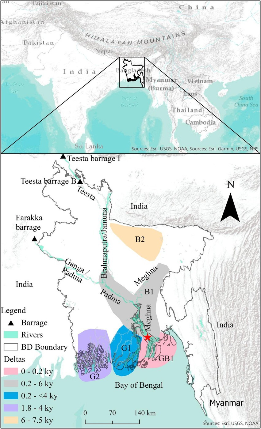
Figure 1. Location of major rivers in Bangladesh and Holocene delta of Ganges (G1, G2), Brahmaputra (B1, B2), and Ganges–Brahmaputra (GB1) with age. The red star denotes the approximate mouth’s location where Meghna meets the Bay of Bengal, adopted from Allison et al. (2001), Rahman et al. (2020); and Sarker et al. (2013).
2.2 Long-term shoreline migration
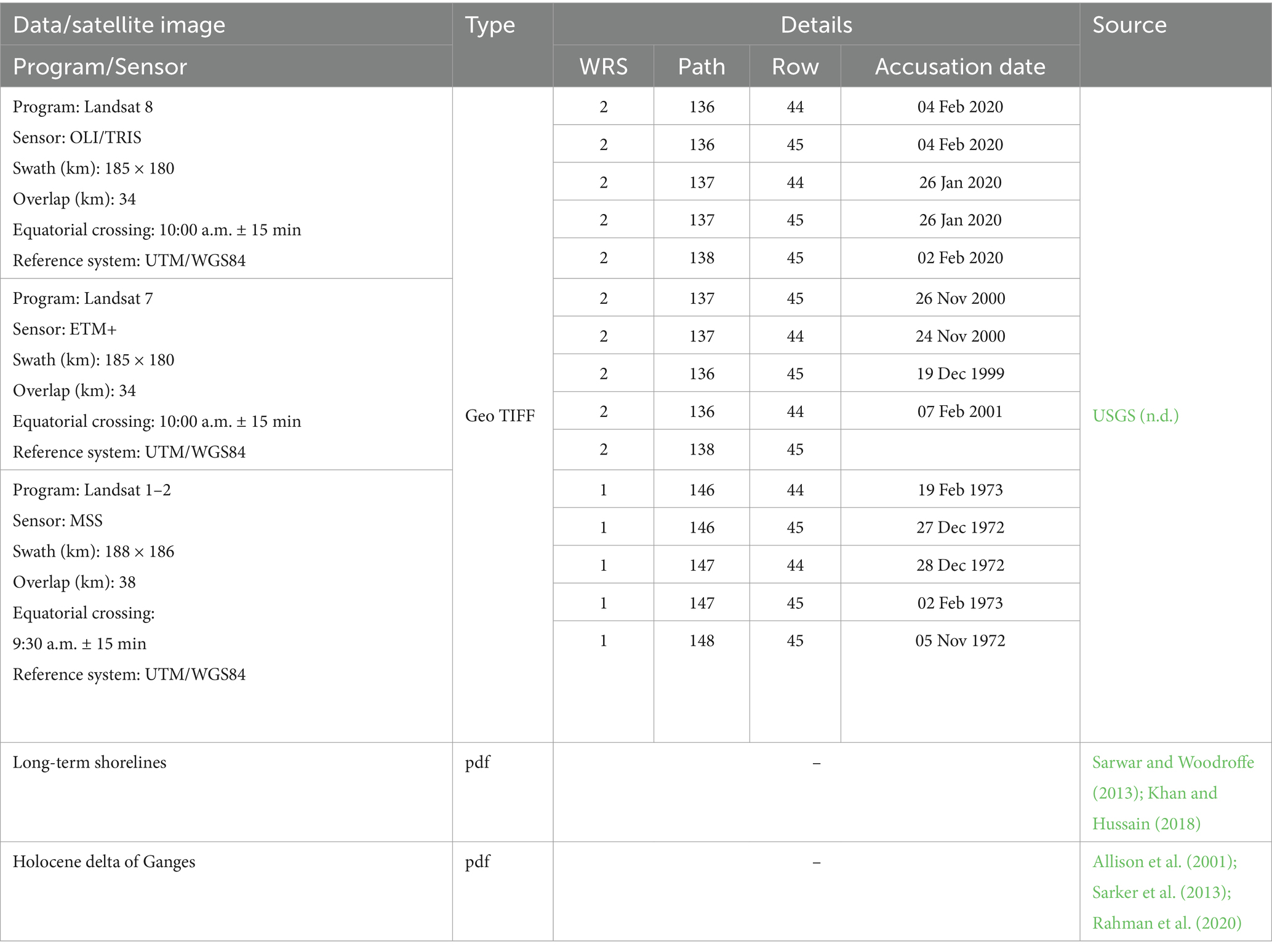
Data for the long-term shoreline was derived from secondary sources (Table 1). The shoreline locations since 9,000 BP were in PDF format, converted to JPG format. The JPG formatted data were imported to ArcGIS Pro, a commercial GIS software. In ArcGIS Pro, the JPG data were georeferenced based on ArcGIS Pro Basemap (Streets) using the WGS 1984 UTM Zone 46 N geospatial reference system (GRS). In that reference system, the location of shorelines in 9,000 BP, 7,000 BP, 5,000 BP, and 174 BP were digitized using the ArcGIS Pro standard digitization tool.
To analyze long-term shoreline migration, four transects (Cross Lines A, B, C, and D) were drawn at specific places perpendicular to the general direction of the coastline that represent different geomorphological and hydrological features of the coastline. The initial objective of these transects was to standardize the measurement of shoreline migration throughout various time periods. The second objective was to record the variation in shoreline movement caused by various local dynamics, including coastal erosion and riverine sedimentation. Using a Measure Distance tool in ArcGIS Pro, the differences in the location of shorelines at different times were measured in m along the transects. Then, the migration during a specific time interval, e.g., 9,000–7,000 BP, was calculated yearly.
2.3 Estimation of shoreline migration since 1970s
2.3.1 Description of data sources
Satellite images from Landsat programs were used to quantify the short-term shoreline migration over time in the study area (Table 1). The images were taken from EarthExplorer, the Science for a Changing World archive of the United States Geological Survey (USGS, n.d.).The images were captured in the winter season with cloud-free conditions. Details of the image properties can be seen in Tables 1, 2.
2.3.2 Image processing
Normalized Differentiate Water Index (NDWI) operation conducts pixel by pixel. Therefore, all images’ spatial resolution has to be the same. The spatial resolution of OLI/TRIS (Landsat 8) and ETM+ (Landsat 7) data was the same at 30 m, which differs from the pixel resolution of MSS (Landsat 1–2) (60 m). Therefore, MSS images were resampled from 60 m to 30 m by applying the first-ordered resampling technique of ArcGIS Pro software.
Normalized Difference Water Index (NDWI) was calculated as in equation 1 (e.g., Li et al., 2013; McFeeters, 2013; Islam et al., 2021b).
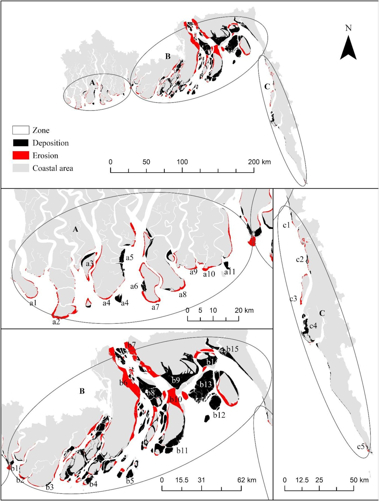
The NDWI was calculated using Map Algebra of ArcGIS Pro. The NDWI layers were classified such that NDWI <0.15 to other than water and NDWI > = 0.15 to water. This classification was judged by visual interpretation from False Color Composition (FCC) images of the corresponding year. This classification was level I (e.g., water, land), can be classify without ancillary data based on visual interpretation (Thompson, 1996). Secondly, NDWI is widely used to detect waterbody from land (e.g., Li et al., 2013; McFeeters, 2013; Tallor et al., 2021; Islam et al., 2021b) and thirdly, the results were consistent with others (e.g., Mullick et al., 2020; Matin and Hasan, 2021). NDWI is a simple and not computationally expensive but provide comparable results to other methods. Therefore, we strict to NDWI in this study to detect waterbody. The FCC images were generated by introducing Green, Red, and NIR bands to the Blue, Green, and Red channels, respectively. Further, the coastline was demarcated into zones A, B, and C to quantify erosion and deposition, as shown in Figure 2.
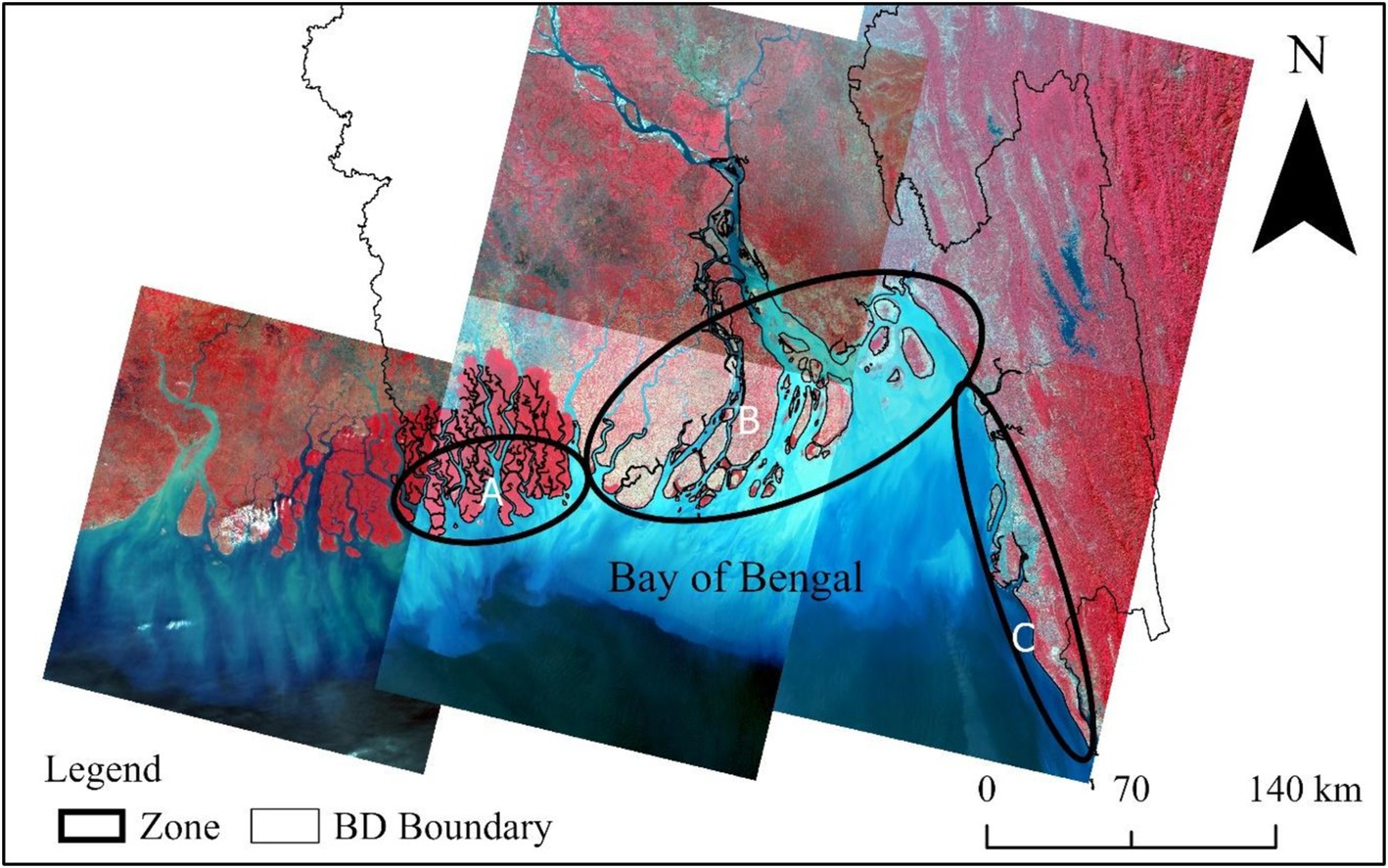
Figure 2. Study area with Landsat 8 data (in 2020) in RGB composite bands, with three different zones (A–C).
2.4 Expert interview: knowledge on coastal community’s livelihood resilience practice
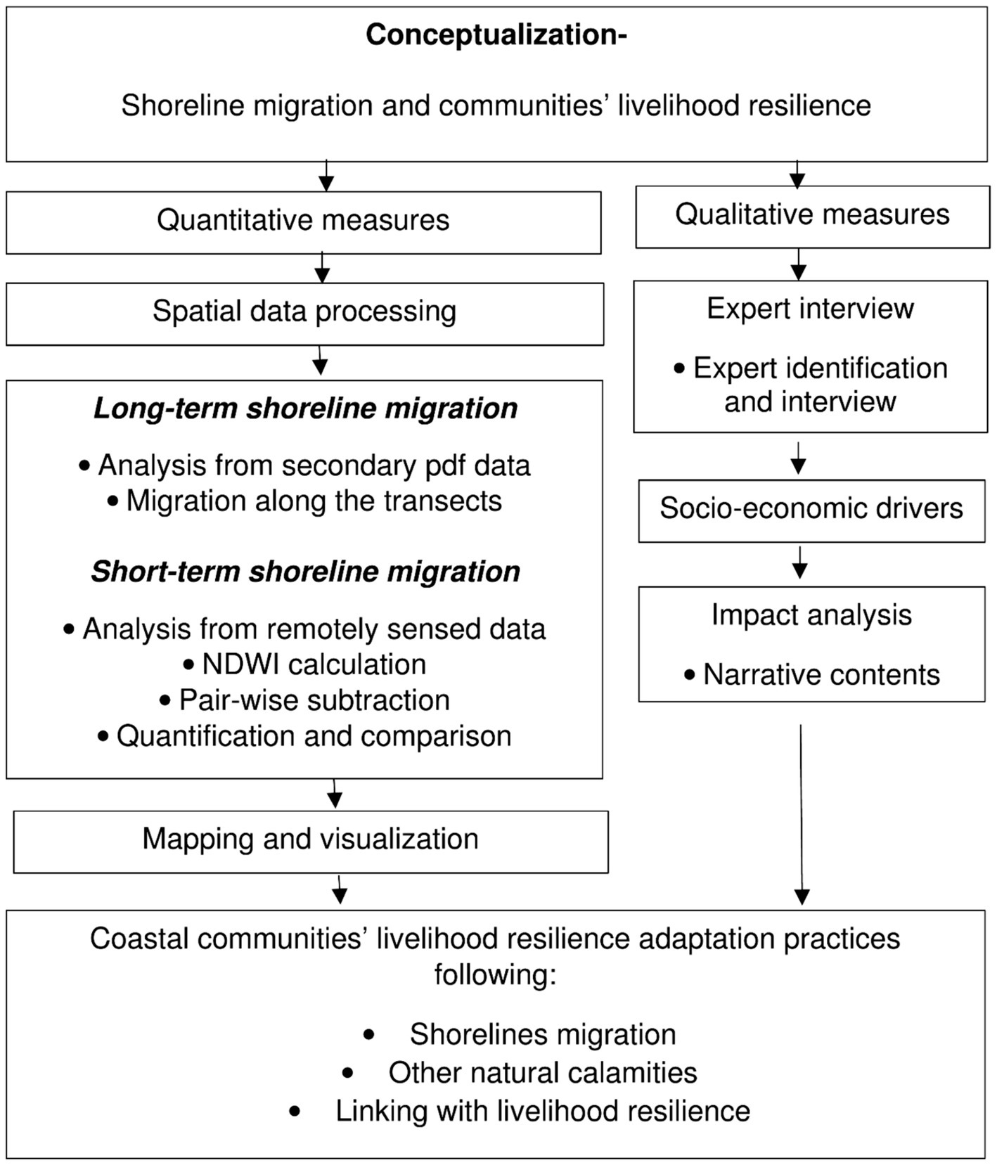
Contemporary coastal communities’ livelihood resilience practices are reviewed by investigating experts’ opinions. The experts were chosen based on their professional linkage with coastal communities’ resilience in Bangladesh. The experts who are activists on the ground and/or research in Bangladesh were considered. Six experts (three national and three from foreign institutes) were selected. The expert opinions were taken through online interviews of about 40 min to an hour through Microsoft Teams. Seven interviews with six experts were recorded. The interviews were opened with quite open questions, e.g., “What are your opinions on most recent projects and programs conducted for the coastal communities’ resilience in Bangladesh?” followed by other questions “what are the specific actions on livelihood resilience by BD govt. and local and international NGOs?,” what activities are adopted by the communities on this regard?” and so on. The interviews were recorded and extracted later and summarized in narrative form (e.g., Islam et al., 2023). The methodology of this study is presented by a flowchart in Figure 3.
3 Results
3.1 Dynamics of shoreline migration
The shorelines of the Bangladeshi coast have been very dynamic over time, from 9,000 BP to the present (Figure 4). The most dynamic location was found along the transect (Cross Line) C, and it was observed the most stable location at the Cox’s Bazar. This is a natural phenomenon for a shoreline to be the most dynamic at the mouth of a major river system to the sea. Through the Padma River (along the Cross Line C), most of the upstream water of the Ganga/Padma, Brahmaputra/Jamuna, and Meghna rivers discharge to the Bay of Bengal (Figure 1). However, at the most recent time, 174 BP–70 AP, the shoreline at Cross Line B moved with the high rate of ⁓187.6 m/yr. (Figure 4, Table 3). In the near part, since 5,000 BP, the shoreline moved very slowly along transect A, which might have affected forest land coverage, the Sundarbans (Figure 4). Along the transect D, the shoreline has been almost static, which might be the effect of hill track (Figure 4, Table 2). The dynamics of shorelines in Bangladesh are presented in Figure 4, and the quantified movement of shorelines with direction is presented in Table 3.
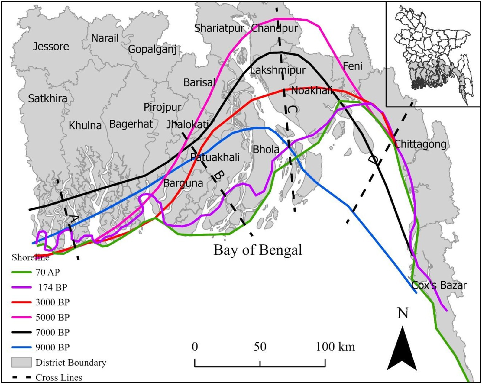
Figure 4. Location of generalized shoreline at different times, derived from Sarwar and Woodroffe (2013) and Khan and Hussain (2018).
Figure 4 offers a visual representation of the generalized shorelines of Bangladesh at various historical points, ranging from 9,000 BP to 70 AP. The shoreline along Cross Line A shows significant inland migration during 5,000–3,000 BP. This area has remained relatively stable since then, with minimal changes observed up to 70 AP. The region across Cross Line B experienced the highest migration rates, particularly between 174 BP and 70 AP, moving south-southeast at an impressive rate of 187.6 m/yr. This high level of dynamism indicates a significant susceptibility to coastal changes and highlights the need for effective management strategies to mitigate the impacts of such rapid movements. The shoreline along Cross Line C exhibited substantial migration southward at a rate of 27.7 m/yr. during 5,000–3,000 BP. The influence of the Padma River, which channels substantial water flow from major river systems, is a key factor driving this significant migration. The shorelines have migrated in various directions over time, influenced by geological and hydrological factors. The areas with higher migration rates, such as Cross Lines B and C, highlight regions that may require focused coastal management efforts to address erosion and land loss.
3.2 Shoreline migration since 1972
Similar to long-term shoreline migration, it moves frequently at the mouth of the Padma River system at the Bay of Bengal (Figure 5B). In the Sundarbans, erosion and deposition were insignificant (Figure 5A). Similarly, on the shoreline along the hill track, the erosion and deposition were also negligible (Figure 5C). Bank of the Padma River next to the mouth, erosion is dominant due to the fluctuation of upstream water flow. Many islands in the Bay of Bengal have grown due to siltation (Figure 5B). Erosion most occurred at the banks in the region. The rate of erosion over the observation time from 1972 to 2020 is almost constant in the southeastern region (Figure 5C). It might vary slightly here and there, but high fluctuation is not observed. On the other hand, most deposition is observed at the southwestern banks at the mouth of the river system (Hr in Figure 5B) and the Bay of Bengal (islands in Figure 5B). For example, Bhasan Char (Bh in Figure 5B) was not observed in 2000. Similarly, Jahangir Char was mainly developed during 2000–2020 (J in Figure 5B). At the southwestern mouth (Hr) was observed in 2020.
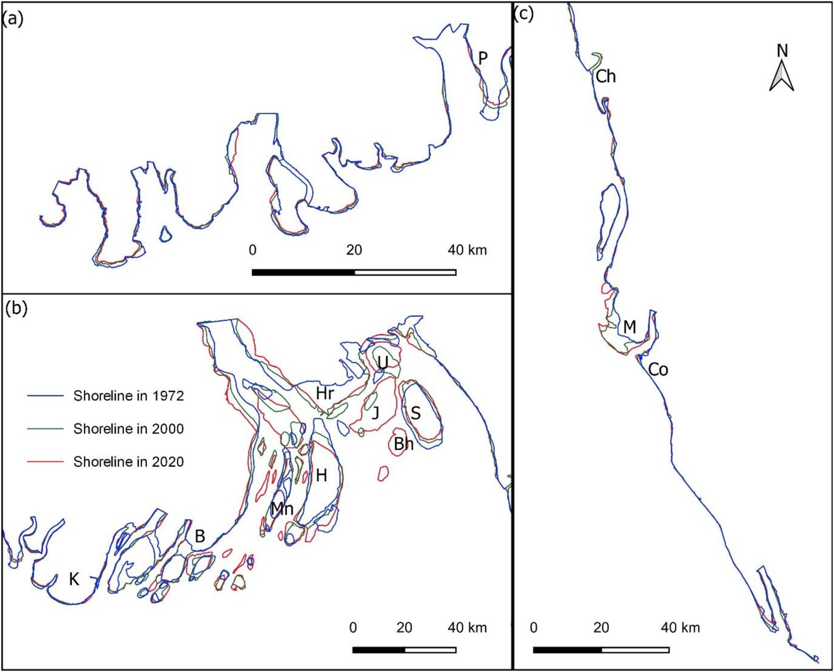
Figure 5. Shoreline location in different years; (a) western, (b) central and (c) eastern parts. Pathorghata (P) in Jhalokati District; Kalapara (K) in Patuakhali District; Bhola (B) and Monpura (Mn) in Bhola District; Hatia (H), Jahangirchar (J), Bhasan Char (Bh), Harani (Hr), Sandip (S) and Urirchar (U) in Noakhali District; Chittagong (Ch) in Chittagong District; Moheshkhali (M) and Cox’s Bazar (Co) in Cox’s Bazar District are illustrated.
The high-resolution spatial analysis of erosion and deposition patterns along the shoreline of Bangladesh from 1972 to 2020, depicted in Figure 6, reveals significant changes predominantly at the banks of major rivers and the northern faces of islands. Zone A, located in the southwestern part of the map, primarily covers the Sundarbans region and adjacent areas. Zone B spans a broader area, including the mouth system of the rivers. Zone C stretches along the eastern coastline, covering areas of hill-track. In these zones, areas marked in red indicate regions of substantial erosion, while those marked in black represent zones of significant deposition.
Specifically, the areas marked as b6, b7, and b10 exhibit the most substantial erosion. The northern bank of the river mouth at location b6 experienced an extensive erosion estimated at 22048.3 ha, while location b7 recorded 10881.7 ha of erosion, and the north face of the island at location b10 faced erosion totaling 18284.3 ha (Figure 6B; Table 4).
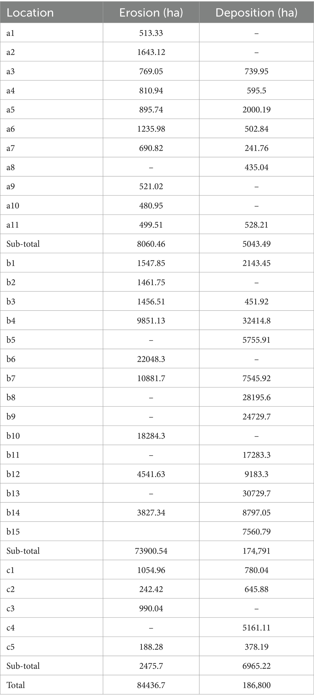
Table 4. Erosion and deposition during 1972–2020 at different locations in the shoreline of Bangladesh.
The detailed quantitative analysis, as summarized in Table 4, highlights the extensive changes in the shoreline over the past five decades. Between 1972 and 2020, the total area affected by erosion is estimated at 84436.7 ha. During the same period, deposition was significantly higher, amounting to 186,800 hectares. This indicates that deposition processes outpaced erosion by approximately 2.2 times. The distribution of erosion and deposition across different locations is varied. For instance, in region A, significant deposition areas include a5 and a8, with areas of 2000.19 ha and 435.04 ha, respectively, while notable erosion occurred at a1 and a2, with 513.33 ha and 1643.12 ha, respectively. In region B, substantial deposition was recorded at b4 and b13, with 32414.8 ha and 30729.7 ha, respectively. Erosion was predominant in areas such as b6 and b10, with areas of 22048.3 ha and 18284.3 ha, respectively. Region C experienced a mix of erosion and deposition, with significant deposition at c4 (5161.11 ha) and considerable erosion at c1 (1054.96 ha).
3.3 Impact on living and adaptation practice in coastal Bangladesh
The coastal region of Bangladesh is highly vulnerable to the impacts of climate change, which has significant consequences for the local communities. Currently, rising sea levels, cyclones, coastal erosion, and other hazards are jeopardizing the livelihoods of the coastal communities, making it difficult for them to carry out their activities and forcing them to adopt new strategies for survival. Respondents from interviews shed light on the multi-faceted impact of these challenges, focusing on living conditions, adaptation efforts, and migration trends.
3.3.1 Impact on living
The coastal communities are highly vulnerable to climate-induced changes as they depend on land and sea resources for their livelihood. According to a respondent, “the communities along the coastal region largely depend on agriculture and fisheries are threatened by the encroaching water and saltwater intrusion due to rising sea levels.” Soil salinity influences agricultural productivity and fish mobility in aquatic environments, directly impacting food security and income for the coastal communities. Aquaculture, particularly shrimp farming, has emerged as a common adaptation technique to overcome rising salinity; however, it has other risks, and its sustainability is questionable. Moreover, many families in the coastal region suffer from poor health as the available potable water supply and sanitation remain inadequate. These environmental changes impact the life cycle demographics very aggressively and place an additional strain on the volatile groups that are on the verge of socio-economic breakdown.
Climate change and resilience experts highlight the inequities between wealthier and marginalized people of the coastal region. A respondent mentioned, “After any catastrophic event, poor and marginalized families struggle to recover, whereas those with economic means can rebuild quickly.” He also argued, “This inequality has to be rectified by adopting meaningful resilience strategies, focusing on the need of at-risk communities to facilitate their capacity to adapt and recover.”
3.3.2 Adaptation activities
Adaptation efforts have emerged as the dominant approach to addressing these challenges in the coastal region of Bangladesh. A respondent underscored “the difference between adaptation and resilience, explaining that while communities have been highly adaptable, transitioning from conventional agriculture to shrimp farming in response to growing soil salinity, this does not always imply resilience.” Some of the adaptation measures include the construction of embankments and cyclone shelters to protect lives and properties. Another respondent emphasized, “many of these embankments are poorly constructed, making them susceptible to damage, particularly during powerful cyclones and floods.” Other initiatives like mangrove reforestation and the introduction of saline-tolerant crop varieties aim to improve sustainability and reduce environmental vulnerability. However, experts identified these as reactive, expressing the need for proactive planning and investment in long-term infrastructure.
Additionally, the involvement of local communities in adaptation strategies remains crucial. Experts supported the integration of community knowledge and participation in decision-making processes. It is essential to consider that local communities are the first to experience the effects of climate change; hence they are the most vulnerable groups; their traditional knowledge and practices can be instrumental in shaping effective adaptation strategies.
Another respondent commented on the coping capacities of the coastal communities and said, “People are now more educated and aware of different disasters. For example, many residents in the coastal region have raised their homes above flood level and adopted newer construction methods in response to frequent flooding.” Such grassroots efforts demonstrate the determination of local communities to build resilience with the resources they have during a crisis period.
Involvement of local government, locally honored people, e.g., schoolteachers, and imam of the masjid (religious leader of the mosque) to contributing to the improvement of community resilience is significant and practical. A respondent suggested, “Union Parishad (lowest local govt. unit in rural Bangladesh from hierarchy) members along with other community leaders must take proactive roles in spreading education initiatives focusing on climate adaptation and preparedness.” He also underlined, “the need for community-level engagement in educating people about climate risks, particularly through local institutions like mosques and other formal institutions within the clusters are practical and effective.”
Migration is a significant and distressing adaptive process by the coastal communities to cope with these changes. As environmental degradation deteriorates the livelihood of coastal communities, many people are forced to migrate either temporarily or permanently. Insights from the interview reveal that the loss of arable land, reduced fish stocks, and destruction of homes due to cyclones and coastal erosion directly facilitate short-term and long-term migrations. A respondent said, “Temporal migration has been increasingly common among individuals who travel from rural and coastal areas and looking for job opportunities in urban areas during the off-peak farming period.” This migration is often because of a lack of job opportunities in affected regions, where traditional livelihoods have become unsustainable. Temporal migration also happens when people flee from environmental conditions inflicted on them. A respondent explained, “This migration disrupts social structures, reducing protection for those who are left behind. And the culture of mutual assistance is still prevalent but has weakened over time as consecutive shocks overwhelm people’s ability to support one another.” However, permanent migration is becoming necessary for several coastal families as repeated natural or climatic calamities have threatened their ability to restore or modify their homes. As a result, they move to divisional and capital cities like Dhaka, Khulna, and Chittagong often living in overcrowded slum areas, increasing the burden on urban infrastructure.
The displacement of communities has profound regional, environmental as well as social consequences. A respondent commented, “migration is an important factor that can dismantle social conformity that in turn affects resilience.” Migrants often live in very vulnerable conditions in urban areas with limited access to healthcare, education, and social services, hence increasing the suffering of displaced populations.
4 Discussion
Climate change significantly influences shoreline movement in the coastal region of southern Bangladesh, affecting erosion, flooding, salinity, and overall coastal landscape dynamics. Rising sea levels driven by climate change through melting glaciers threaten coastal regions by increasing erosion and inland salinity intrusion (Griggs and Reguero, 2021). The shoreline dynamics of Bangladesh emphasize that the interaction of riverine sediment discharge, longshore sediment transport, and coastal currents influence the ongoing erosion and deposition patterns (Hossain et al., 2023).
The Bangladeshi coastline has changed a lot over time, showing its dynamic nature, as discussed by both historical data and recent satellite image analysis. The combined influence of major river systems, including Ganga/Padma, Brahmaputra/Jamuna, and Meghna, especially at the Padma River’s mouth, plays a significant role in shaping the shoreline. Findings show that the southern region of Bangladesh is at high risk of erosion, which is corroborated by findings from other research. Matin and Hasan (2021) analysed the shoreline changes along the coast of Bangladesh and found that during 1989–2019, the western zone experienced significant erosion of 5,037 ha and only 970 ha deposition. The central zone had both considerable erosion and deposition. Bhola island consistently eroded, losing nearly 6,000 ha, and the Noakhali district saw significant land gain, with up to 600 ha of shoreline advancing at rates of 230 m/year.
The shoreline dynamics of the broader coastal region of Bangladesh have exhibited significant changes over the past several decades, driven by complex interactions of natural and anthropogenic factors (e.g., Mullick et al., 2020). Hatiya Island has seen significant shoreline changes, with continuous erosion in the north due to its position at the mouth of the Meghna River estuary, where water flows fastest. This matches our findings that river mouths like the Padma River are especially prone to shoreline changes. It has been seen that rising water levels and changing rainfall patterns significantly influence shoreline dynamics, with higher erosion rates highlighting the vulnerability of alluvial islands (Kabir et al., 2020). Strong water flow from major river systems contributes to shoreline migration by continuous erosion and deposition (Hein et al., 2019). The dynamic shoreline changes in Bangladesh highlight the targeted need for specific coastal management strategies. Areas with higher erosion in the coaster region require immediate attention to prevent land loss and protect local people, whereas regions with accretion offer opportunities for land reclamation and development (Salman et al., 2018). It is evident that the shoreline changes in Bangladesh are highly localized and influenced by various factors, including river dynamics, tidal effects, and human interventions (Rahman et al., 2022).
The salinity contour in coastal Bangladesh from IWM and CEGIS (2007) highlights significant spatial and temporal variations influenced by seasonal changes and projected future conditions. During the dry season in 2007, the salinity intrusion extends further inland, particularly affecting regions like Satkhira, Khulna, and Patuakhali. Five parts per thousand (ppt) salinity contour during the dry season, showing a substantial inland reach. The monsoon season sees a notable decrease in salinity levels, with the 5 ppt salinity contour line receding closer to the coastline. During this period, regions such as Bagerhat, Barguna, and Bhola experience significant relief from high salinity levels. The average salinity levels in 2007 offer a comprehensive view of the annual salinity dynamics. This average line shows moderate salinity intrusion, balancing the extremes observed during the dry and monsoon seasons. Coastal areas like Noakhali and Lakshmipur are moderately affected, reflecting the interplay between seasonal freshwater inflows and saline water intrusion. The predicted salinity levels for 2050 suggest a concerning trend of increasing salinity intrusion inland. This projection accounts for factors such as climate change, sea-level rise, and potential changes in river discharge patterns. The projected 2050 salinity line extends further inland compared to the 2007 observations, implying that areas currently experiencing moderate salinity levels might face more severe conditions in the future. Districts like Satkhira, Khulna, Patuakhali, and Cox’s Bazar are likely to be significantly impacted, with potential adverse effects on agriculture, freshwater availability, and the overall livelihood of the coastal communities. The interplay of freshwater flow, tidal activity, and climatic factors affects salinity levels, influencing agriculture, drinking water availability, and local livelihood (Akter et al., 2020). During dry seasons, less freshwater flows towards the coastal area by major river systems and increased evaporation rates lead to saline water intrusion towards inland areas, particularly affecting regional districts including, e.g., Satkhira, Khulna, Patuakhali (e.g., Miah et al., 2020; Bricheno et al., 2021), which is even further infiltrated by the Farakka Dam at Ganga (Gain and Giupponi, 2014; Islam, 2014). However, during the monsoon seasons, increased river discharge from the inland area restricts saline water from entering the inland region and provides significant relief to coastal areas, e.g., Bagerhat, Bhola, Barguna (Haque, 2006; Sun et al., 2022). The projected trends suggest that, by 2050, there will be a concerning rise in saltwater intrusion, posing risks to both coastal ecosystems and communities (Dasgupta et al., 2015).
The professionals (from the interview) emphasized the urgent need for adaptive strategies to address issues like increasing sea levels, frequent cyclones, and shoreline erosion to reduce the vulnerability of coastal communities. Economic inequities increase the socioeconomic vulnerabilities of coastal communities that are highly affected by salinity intrusion, equally found by others (e.g., Dasgupta et al., 2015; Akter et al., 2020). Mangrove afforestation and embankment construction might be effective tools for long-term shoreline management (e.g., Hossain et al., 2023; Kabir et al., 2020). Inadequacy of coastal infrastructure, particularly embankments, which are poorly constructed and remain vulnerable, compromising community resilience (e.g., Schroeder, 2014; Hein et al., 2019; Griggs and Reguero, 2021). Identifying the damage to existing infrastructure and focusing on infrastructure resilience and the need for adaptive measures against extreme climatic events beyond past climatic patterns are also vital.
Incorporating community-based adaptations with scientific interventions is also recommended by the respondents, and this is equally mentioned by others (e.g., Haque, 2006; Rahman et al., 2022). Many residents in the coastal communities have adopted different preventive measures in response to frequent flooding, showcasing their determination to build resilience with available resources (e.g., Mullick et al., 2020; Matin and Hasan, 2021). Respondents from the interview also emphasized social capital and leadership in post-disaster recovery, a major component often missing in many research. The traditional culture of mutual assistance has weakened over time as consecutive shocks overwhelm people’s ability to support one another.
The inclusive analysis of dynamic shoreline changes and salinity intrusion in the coastal regions highlights the complex interactions between natural processes and human activities. There is a critical need for adaptive coastal management strategies to protect vulnerable coastal communities. Effective coastal management should include sustainable land-use practices, resilient infrastructure development, and community engagement to mitigate erosion risks and enhance adaptive capacity. Integrated water management approaches should be adopted to address salinity intrusion and to balance freshwater availability in the coastal region. The results from this study emphasized the necessity of local governance and community engagement in spreading education initiatives focusing on climate adaptation and preparedness, particularly through local institutions like mosques. Future research and policy initiatives are necessary to improve predictive modeling, stakeholder involvement and adaptive governance that help in building resilience against environmental challenges.
However, this study is not free of error. (a) It only considered digital number differencing method in remote sensing data processing to estimate short-term shorelines migration. Supervised image classification or automated machine learning process might provide slight better shorelines detection. (b) Instead of gross results between 1972 and 2020, several time intervals might provide more insights of shorelines dynamics (c) This was dependent to fewer respondents for qualitative assessment. (d) Other environmental and socio-economic dimensions could be integrated to visualize the complete scenarios for the impacts of climate change on shoreline migration of coastal communities’ resilience in Bangladesh.
5 Conclusion and recommendations
This study points out the critical impact of climate change on shoreline dynamics and saline water intrusion in the coastal region of Bangladesh. Our study indicates significant erosion along the shoreline, particularly in the southern coastal region with large areas of coastal land loss documented, over 5,000 hectares in certain zones from 1989 to 2019. The results illustrate that the interaction between riverine sediment discharge and tidal effects plays a central role in shaping these coastal landscapes (Figure 6; Akter et al., 2020; Hossain et al., 2023). The analysis explains that the impact of sediment erosion is more vulnerable at the river mouth like the Padma River, due to the progressive rise in sea level and increased salinity levels, which threatens agricultural productivity and local livelihoods.
Effects of salinity intrusion on agriculture and fisheries, aligning with the quantitative findings of increases salinity levels during dry seasons in the southwest districts in Bangladesh (IWM and CEGIS, 2007). Infrastructural vulnerability relates to structural designs and construction that do not adequately consider climatic variability, which could jeopardize community safety and recovery during extreme weather events. However, some key adaptation strategies have reduced the socio-economic vulnerabilities of the people living in the coastal areas but insignificantly. Our study findings suggest addressing the challenges of shoreline erosion and salinity intrusion by:
• Adaptive Coastal Management: Implementing Integrated Coastal Management strategies to consider localized vulnerabilities is crucial. This includes rehabilitation of existing natural defences like mangrove restoration and the construction of robust embankments to mitigate erosion and flooding.
• Community Involvement: Involve local communities in the planning and development of adaptation strategies as well as in major decision-making. By fostering community participation and involving local knowledge and practices, coastal management would be more efficient and sustainable.
• Integrated Water Resource Management: It is vital to formulate all-inclusive water management practices and policies that facilitate freshwater availability and its necessity to agriculture. Attempts should be made to maintain river flow during dry seasons to combat salinity intrusion in the river delta and protect the ecosystem and agricultural production in adjacent areas.
• Continued Research and Monitoring: Promote ongoing research initiatives and monitor shoreline changes and salinity dynamics regularly to enhance predictive coastal modeling. This will enable more proactive measures and ensure that the communities can adapt to potential changes in coastline and other environmental shifts.
• Policy Development: Encourage robust policy frameworks to facilitate adaptive governance and stakeholder collaboration. However, policies should integrate scientific research and knowledge of local communities, recognizing the importance of the multifaceted challenges of climate change.
Recommendations for Stakeholders:
• For Policymakers: Develop policies that integrate both scientific research and indigenous knowledge, addressing long-term and short-term adaptation needs across local, regional, and national scales.
• For Urban Planners: Incorporate climate resilience into urban planning strategies, focusing on strengthening infrastructure to withstand extreme weather events and supporting adaptive governance at the local level.
• For Local Communities: Engage communities in planning and decision-making processes, integrating local knowledge with scientific approaches to build resilience. Encourage the adoption of community-based adaptation measures, such as mangrove restoration, alongside infrastructure development.
By implementing these recommendations, Bangladesh can strengthen its resilience against climate impacts, safeguard vulnerable coastal communities, and promote sustainable development in its coastal regions. Future research should continue to explore the interplay between environmental dynamics and socio-economic factors, providing a comprehensive understanding that informs effective policy and community practices.
Data availability statement
Publicly available datasets were analyzed in this study. This data can be found at: https://earthexplorer.usgs.gov/.
Ethics statement
Ethical approval was not required for the studies involving humans because it was only involved anonymous interview with key expert. The studies were conducted in accordance with the local legislation and institutional requirements. Written informed consent for participation was not required from the participants or the participants’ legal guardians/next of kin in accordance with the national legislation and institutional requirements because oral consent was received before interview.
Author contributions
MI: Conceptualization, Data curation, Formal analysis, Investigation, Methodology, Project administration, Resources, Software, Supervision, Validation, Visualization, Writing – original draft, Writing – review & editing. MMH: Data curation, Formal analysis, Methodology, Software, Writing – original draft. NH-M: Writing – review & editing. MZH: Writing – review & editing. SS: Supervision, Writing – review & editing.
Funding
The author(s) declare that no financial support was received for the research, authorship, and/or publication of this article.
Acknowledgments
The authors would like to thank who took part in interview. The editor and the reviewers are greatly acknowledged for their constructive comments.
Conflict of interest
The authors declare that the research was conducted in the absence of any commercial or financial relationships that could be construed as a potential conflict of interest.
Generative AI statement
The author(s) declare that no Gen AI was used in the creation of this manuscript.
Publisher’s note
All claims expressed in this article are solely those of the authors and do not necessarily represent those of their affiliated organizations, or those of the publisher, the editors and the reviewers. Any product that may be evaluated in this article, or claim that may be made by its manufacturer, is not guaranteed or endorsed by the publisher.
References
Afjal Hossain, M., Imran Reza, M., Rahman, S., and Kayes, I. (2012). “Climate change and its impacts on the livelihoods of the vulnerable people in the southwestern coastal zone in Bangladesh” in Climate change and the sustainable use of water resources. ed. W. Leal Filho (Berlin: Springer), 237–259.
Akter, S., Ahmed, K. R., Marandi, A., and Schüth, C. (2020). Possible factors for increasing water salinity in an embanked coastal island in the Southwest Bengal Delta of Bangladesh. Sci. Total Environ. 713, 136668–136619. doi: 10.1016/j.scitotenv.2020.136668
Allison, M. A., Khan, S. R., Goodbred, S. R., and Kuel, S. A. (2001). Stratigraphic evolution of the late Holocene Ganges-Brahmputra lower delta plan. Sediment. Geol. 155, 317–342. doi: 10.1016/S0037-0738(02)00185-9
Arfanuzzaman, M. (2024). Bangladesh’s pathways to climate-resilient development: a methodical review. World Dev. Sustain. 4:100144. doi: 10.1016/j.wds.2024.100144
Bianchi, E., and Malki-Epshtein, L. (2021). Evaluating the risk to Bangladeshi coastal infrastructure from tropical cyclones under climate change. Int. J. Disaster Risk Reduct. 57:102147. doi: 10.1016/j.ijdrr.2021.102147
Bricheno, L. M., Wolf, J., and Sun, Y. (2021). Saline intrusion in the Ganges-Brahmaputra-Meghna megadelta. Estuar. Coast. Shelf Sci. 252, 107246–107215. doi: 10.1016/j.ecss.2021.107246
Dasgupta, S., Akhter Kamal, F., Huque Khan, Z., Choudhury, S., and Nishat, A. (2015). “River salinity and climate change: evidence from coastal Bangladesh,” in World Scientific Reference on Asia and the World Economy (World Scientific), 205–242. doi: 10.1142/9789814578622_0031
Dasgupta, S., Huq, M., Khan, Z. H., Ahmed, M. M. Z., Mukherjee, N., Khan, M. F., et al. (2014). Cyclones in a changing climate: the case of Bangladesh. Clim. Dev. 6, 96–110. doi: 10.1080/17565529.2013.868335
Gain, A., and Giupponi, C. (2014). Impact of the Farakka dam on thresholds of the hydrologic flow regime in the lower Ganges River basin (Bangladesh). Water (Basel) 6, 2501–2518. doi: 10.3390/w6082501
Goodbred, S. L., and Kuehl, S. A. (2000). The significance of large sediment supply, active tectonism, and eustasy on margin sequence development: late quaternary stratigraphy and evolution of the Ganges–Brahmaputra delta. Sediment. Geol. 133, 227–248. doi: 10.1016/S0037-0738(00)00041-5
Griggs, G., and Reguero, B. G. (2021). Coastal adaptation to climate change and sea-level rise. Water (Basel) 13, 1–26. doi: 10.3390/w13162151
Haque, S. A. (2006). Salinity problems and crop production in coastal regions of Bangladesh. Pak. J. Bot. 38, 1359–1365.
Haque, S. E., and Nahar, N. (2023). Bangladesh: climate change issues, mitigation, and adaptation in the water sector. ACS ES&T Water 3, 1484–1501. doi: 10.1021/acsestwater.2c00450
Haque, A., Rahman, M. H., and Rahman, D. (2019). An evaluation of sea level rise vulnerability and resilience strategy to climate change in the coastline of Bangladesh. Int. J. Environ. Sci. Nat. Resour. 18, 56–70. doi: 10.19080/IJESNR.2019.18.555983
Hein, C. J., Fallon, A. R., Rosen, P., Hoagland, P., Georgiou, I. Y., FitzGerald, D. M., et al. (2019). Shoreline dynamics along a developed river mouth Barrier Island: multi-decadal cycles of Erosion and event-driven mitigation. Front. Earth Sci. (Lausanne) 7, 1–23. doi: 10.3389/feart.2019.00103
Hossain, M. S., Yasir, M., Shahriar, M. S., Jahan, M., Liu, S., and Niang, A. J. (2023). Morphological change assessment of a coastal island in SE Bangladesh reveal high accumulation rates. Reg. Stud. Mar. Sci. 62, 102969–102917. doi: 10.1016/j.rsma.2023.102969
Islam, M. T. (2014). Vegetation changes of Sundarbans based on Landsat imagery analysis between 1975 and 2006. Acta Geogr. Debr. Landsc. Environ. Ser. 8, 1–9. Available at: https://ojs.lib.unideb.hu/landsenv/article/view/2304
Islam, S. M. D.-U., and Bhuiyan, M. A. H. (2018). Sundarbans mangrove forest of Bangladesh: causes of degradation and sustainable management options. Environ. Sustain. 1, 113–131. doi: 10.1007/s42398-018-0018-y
Islam, M. T., Charlesworth, M., Aurangojeb, M., Hemstock, S., Sikder, S. K., Hassan, M. S., et al. (2021a). Revisiting disaster preparedness in coastal communities since 1970s in Bangladesh with an emphasis on the case of tropical cyclone Amphan in May 2020. Int. J. Disaster Risk Reduct. 58, 102175–102115. doi: 10.1016/j.ijdrr.2021.102175
Islam, M. T., Islam, M. T., and Rabbi, A. (2021b). A quantitative approach for geographical vulnerability assessment of Bhasan char, Bangladesh, using remote sensing and GIS, in 2nd intercontinental Geoinformation days (IGD), (Mersin), 52–55.
Islam, M. T., Sikder, S. K., Charlesworth, M., and Rabbi, A. (2023). Spatial transition dynamics of urbanization and Rohingya refugees’ settlements in Bangladesh. Land Use Policy 133, 106874–106811. doi: 10.1016/j.landusepol.2023.106874
IWM and CEGIS (2007). Investigating the impact of Relative Sea-level rise on coastal communities and their livelihoods in Bangladesh, Dhaka.
Kabir, M. A., Salauddin, M., Hossain, K. T., Tanim, I. A., Saddam, M. M. H., and Ahmad, A. U. (2020). Assessing the shoreline dynamics of Hatiya Island of Meghna estuary in Bangladesh using multiband satellite imageries and hydro-meteorological data. Reg. Stud. Mar. Sci. 35, 101167–101111. doi: 10.1016/j.rsma.2020.101167
Khan, E., and Hussain, N. (2018). Coastline dynamics and raising landform: a geo-informatics based study on the Bay of Bengal, Bangladesh. Indones. J. Geogr. 50, 41–48. doi: 10.22146/ijg.26655
Li, W., Du, Z., Ling, F., Zhou, D., Wang, H., Gui, Y., et al. (2013). A comparison of land surface water mapping using the normalized difference water index from TM, ETM+ and ALI. Remote Sens. 5, 5530–5549. doi: 10.3390/rs5115530
Matin, N., and Hasan, G. M. J. (2021). A quantitative analysis of shoreline changes along the coast of Bangladesh using remote sensing and GIS techniques. Catena (Amst) 201, 105185–105111. doi: 10.1016/j.catena.2021.105185
McFeeters, S. K. (2013). Using the normalized difference water index (NDWI) within a geographic information system to detect swimming pools for mosquito abatement: a practical approach. Remote Sens. 5, 3544–3561. doi: 10.3390/rs5073544
Miah, M. Y., Kamal, M. Z. U., and Islam, M. S. (2020). Impact of salinity intrusion on agriculture of Southwest Bangladesh – a review. Int. J. Agric. Policy Res. 8, 40–47. doi: 10.15739/IJAPR.20.005
Mullick, M. R. A., Islam, K. M. A., and Tanim, A. H. (2020). Shoreline change assessment using geospatial tools: a study on the Ganges deltaic coast of Bangladesh. Earth Sci. Inform. 13, 299–316. doi: 10.1007/s12145-019-00423-x
Poncelet, A., Gemenne, F., Martiniello, M., and Bousetta, H. (2010). “A country made for disasters: environmental vulnerability and forced migration in Bangladesh” in Environment, forced migration and social vulnerability. eds. T. Afifi and J. Jäger (Berlin, Heidelberg: Springer), 211–222.
Rahman, M. M., Haque, A., Nicholls, R. J., Darby, S. E., Urmi, M. T., Dustegir, M. M., et al. (2022). Sustainability of the coastal zone of the Ganges-Brahmaputra-Meghna delta under climatic and anthropogenic stresses. Sci. Total Environ. 829, 154547–154513. doi: 10.1016/j.scitotenv.2022.154547
Rahman, M. M., Salehin, M., Haque, A., Hossain, M. A., Ghosh, T., Ghosh, A., et al. (2020). “Ganges-Brahmaputra-Meghna Delta, Bangladesh and India: a transnational Mega-Delta” in Deltas in the Anthropocene. eds. R. J. Nicholls, W. N. Adger, C. W. Hutton, and S. E. Hanson (Berlin: Springer), 23–51.
Roy, B., Penha-Lopes, G. P., Uddin, M. S., Kabir, M. H., Lourenço, T. C., and Torrejano, A. (2022). Sea level rise induced impacts on coastal areas of Bangladesh and local-led community-based adaptation. Int. J. Disaster Risk Reduct. 73:102905. doi: 10.1016/j.ijdrr.2022.102905
Salman, M. A., Hasan, S. M. R., Ahmed, S., Tahsin, M., and Khan, N. (2018). Shoreline change rate along the southern coast of Bangladesh due to climate change using remote sensing & ArcGIS technology. Int. J. Emerg. Technol. Adv. Eng. 8, 21–28.
Sarker, M. H., Akter, J., and Rahman, M. M. (2013). Century-scale dynamics of the Bengal delta and future development, in 4th International Conference on Water and Flood Management, (Dhaka), 91–104. Available at: https://edepot.wur.nl/317989 (accessed November 3, 2022).
Sarwar, M. G. M., and Woodroffe, C. D. (2013). Rates of shoreline change along the coast of Bangladesh. J. Coast. Conserv. 17, 515–526. doi: 10.1007/s11852-013-0251-6
Schroeder, K. (2014). Embankments in Bangladesh - everyone is needed. Topos Int. Rev. Landscape Archit. Urban Des. 87, 88–93.
Shariot-Ullah, M. (2024). Sea-level rise and sustainable shore protection strategies in the low-lying delta: a case study of Bangladesh. Reg. Stud. Mar. Sci. 71:103424. doi: 10.1016/j.rsma.2024.103424
Sun, Y., Bricheno, L. M., Payo-Payo, M., Rahman, M. M., and Burns, N. M. (2022). Simulation of freshwater transport network and salt flux in the Bangladesh delta. Estuar. Coast. Shelf Sci. 270, 107839–107814. doi: 10.1016/j.ecss.2022.107839
Tallor, A. K., Manhas, D. S., and Kothyari, G. C. (2021). Retrieval of land surface temperature, normalized difference moisture index, normalized difference water index of the Ravi basin using Landsat data. Appl. Comput. Geosci. 9, 100051–100011. doi: 10.1016/j.acags.2020.100051
Thiéblemont, R., Le Cozannet, G., Toimil, A., Meyssignac, B., and Losada, I. J. (2019). Likely and high-end impacts of regional sea-level rise on the shoreline change of European Sandy coasts under a high greenhouse gas emissions scenario. Water (Basel) 11, 1–22. doi: 10.3390/w11122607
Thompson, M. (1996). A standard land-cover classification scheme for remote sensing application in South Africa. S. Afr. J. Sci. 92, 34–42.
Uddin, M. S., Haque, C. E., Khan, M. N., Doberstein, B., and Cox, R. S. (2021). “Disasters threaten livelihoods, and people cope, adapt and make transformational changes”: community resilience and livelihoods reconstruction in coastal communities of Bangladesh. Int. J. Disaster Risk Reduct. 63:102444. doi: 10.1016/j.ijdrr.2021.102444
USGS (n.d.). EarthExplorer. Available at: https://earthexplorer.usgs.gov/ (accessed September 30, 2024).
Keywords: climate change, shoreline migration, spatial analysis, remote sensing-GIS, adaptation practices, mixed method
Citation: Islam MT, Hossain MM, Ha-Mim NM, Hossain MZ and Sikder SK (2025) Climate change impacts on shoreline migration and community livelihood resilience: evidence from coastal Bangladesh. Front. Sustain. 5:1525483. doi: 10.3389/frsus.2024.1525483
Edited by:
Murat Erkoc, University of Miami, United StatesReviewed by:
Shi Xue, University of Illinois at Urbana-Champaign, United StatesBishwajit Roy, University of Lisbon, Portugal
Copyright © 2025 Islam, Hossain, Ha-Mim, Hossain and Sikder. This is an open-access article distributed under the terms of the Creative Commons Attribution License (CC BY). The use, distribution or reproduction in other forums is permitted, provided the original author(s) and the copyright owner(s) are credited and that the original publication in this journal is cited, in accordance with accepted academic practice. No use, distribution or reproduction is permitted which does not comply with these terms.
*Correspondence: Md. Tariqul Islam, dGFyaXF1bC5pc2xhbUBjcmFuZmllbGQuYWMudWs=
†ORCID: Tariqul Islam, https://orcid.org/0000-0003-2831-2252
 Md. Tariqul Islam
 Md. Monabbir Hossain
 Nur Mohammad Ha-Mim4
 Sujit Kumar Sikder