 Hua Ge
 Lingling Zhu
 Bing Mao1,2
- 1Changjiang River Scientific Research Institute, Wuhan, China
- 2Key Laboratory of River & Lake Regulation and Flood Protection in the Middle and Lower Reaches of Changjiang River, Ministry of Water Resources, Wuhan, China
- 3Bureau of Hydrology, Changjiang Water Resources Commission, Wuhan, China
The combined impact of climate change and human activity has brought uncertainty regarding hydrological drought in the lower reaches of the Yangtze River (LYR), thereby threatening the security of regional water resources. To address this uncertainty, based on data from over 70 years, the trends, mutations, and causes of hydrological drought in the LYR were analyzed using the Mann–Kendall test method. The results of this study show that the most extreme annual hydrological drought situation defined by the daily minimum value improved, but the scenario defined by the monthly average intensified in September and October after the flood season, with a mutation in the 2000s after the Three Gorges Reservoir. The continuous decline in water availability during the flood season and the water storage of reservoirs after flooding made 2022 the most severe drought period in nearly 70 years. The rapid storage of reservoirs after flooding has promoted hydrological droughts in the LYR. In future scenarios, the impact of riverbed cutting on hydrological drought should be comprehensively evaluated, and the effects of future tide level changes under global climate change conditions should be measured.
1 Introduction
Hydrological drought refers to the phenomenon wherein river runoff is lower than its normal value or the water level decreases significantly (Linsley et al., 1975) and has been reported to be closely related to vegetation growth (Xiao et al., 2021; Mo et al., 2022). Under the influence of multiple factors such as climate change and human activity, hydrological droughts have occurred at a global scale over the past few decades (Kumar et al., 2014; Wang et al., 2015) and may continue well into the future (Rahiz and New, 2013). These changes have manifested as a gradual increase in the drought period (Seager et al., 2022) and an increase in drought severity in dry areas (Seager et al., 2022), which can cause a series of adverse effects on river management. For example, droughts can drive changes in the availability of water resources during the dry season, leading to crises in water supply management (Zhao et al., 2021), affecting water intake along riverbanks (Ke et al., 2023), and deteriorating navigation conditions (Xia et al., 2021). Ecologically, a drought state in rivers can also affect phytoplankton (Townsend and Douglas, 2017; da Costa et al., 2022) and the transport of organic and inorganic substances in the water (Ran et al., 2017; Shang et al., 2023). Hydrological drought has an even stronger impact on tidal river sections, as it may lead to an increase in tidal dynamics, thereby enhancing sediment resuspension and considerably affecting channel evolution (Hua et al., 2020; Wang et al., 2020). In tidal river sections, drought conditions can also invite the invasion of saltwater from the ocean, thus adversely affecting the utilization of freshwater resources along the river (Xie et al., 2017; Zhu et al., 2021). In addition, tides have a substantial impact on the transport of phytoplankton (Sebastiá et al., 2013), mercury (Chakraborty et al., 2019), and sulfur (Xu et al., 2019) from rivers to the ocean under drought conditions, thereby affecting coastal ecosystems. Therefore, studying the changing characteristics and causes of drought in tidal river sections is important for maintaining water resources and ecological security.
The Yangtze River, the largest river in China, has experienced increasingly intense human activity in recent decades. Coupled with the impacts of climate change, regional droughts have occurred over time (Feng et al., 2018). In some water systems, regional droughts have intensified, posing substantial risks to water security in regions such as Dongting Lake (DTL) (Ge et al., 2022) and Poyang Lake (PYL) (Wu et al., 2021; Xiong et al., 2024). In 2022, the Yangtze River Basin (YRB) experienced its largest drought in nearly a century (Guan and Zeng, 2022). The main stream of the Yangtze River and the DTL and PYL areas connected to it (Lei et al., 2023) experienced severe drought, which has attracted significant research attention. The drought situation of the Yangtze River in recent decades is related to both the decrease in precipitation caused by climate change (Ye et al., 2017) and human activities and is the result of a combination of various factors (Chai et al., 2019). Although the operation of cascade reservoirs, led by the Three Gorges Reservoir (TGR) in the upper reaches of the Yangtze River (UYR), has increased the annual average flow discharge in dry seasons in the reaches downstream of the TGR, it has also advanced the start of the dry season due to water storage after the flood season (Tian et al., 2019) and significantly exacerbated severe hydrological droughts from late September to November (Lai et al., 2014). In addition, since the reservoir impoundment in 2003, the riverbed downstream of the TGR has been downward cut, resulting in a significant decrease in the water level, especially during dry seasons (Yang et al., 2021; Mei et al., 2023). This has further affected the hydrodynamic characteristics of tidal river sections in the lower reaches of the Yangtze River (LYR) (Yuan et al., 2019). The data analysis from 1982 to 2015 indicates that extreme drought events in the YRB have a widespread negative impact on vegetation activity (Jin et al., 2021). As droughts become increasingly severe, the inhibitory effect of drought on vegetation growth becomes more significant (Xu et al., 2024). One study using the catastrophic meteorological drought event in the YRB in 2022 as an example shows that vegetation in the middle and lower reaches of the Yangtze River has higher sensitivity response to drought (Zhao et al., 2024). The proportion of severe and extreme droughts in autumn in the YRB is expected to increase in future years (Zhang et al., 2023). Therefore, it is necessary to further clarify the historical trends and influencing factors of hydrological drought in the LYR to respond more effectively to future changes. Because hydrological characteristics remain consistent in the downstream segments of rivers with reservoirs built upstream (Liu et al., 2024), findings in the LYR can provide a reference for other rivers.
Several studies have focused on typical hydrological drought years in the YRB, including 2006 (Chai et al., 2019), 2011 (Shen et al., 2012; Yang et al., 2013), 2019 (Xu et al., 2020; Liu and Zhou, 2021; Ran et al., 2021), and 2022 (Liang et al., 2023; Lyu et al., 2023). Other studies have also analyzed droughts in the middle reaches of the Yangtze River (MYR) and LYR based on long data series. For example, Shan et al. (2018) analyzed the long-term spatiotemporal characteristics of abrupt dry–wet change events in the MYR and LYR based on daily precipitation observations from 75 rainfall stations during the summers of 1960–2015. Wu et al. (2006) defined long-term drought and flood mutation indices in the MYR and LYR using daily precipitation data from the summers of 1957–2003. Zhang and Wang (2012) analyzed the monthly precipitation during the rainy season and winter in the MYR and LYR from 1961 to 2010. However, owing to its geographical location, the trends and causes of drought in the tidal section of the Yangtze River differ from those in other areas of the basin. The drought dynamics in this region will inevitably create additional requirements for scheduling in upstream cascade reservoir water resource management (Cao et al., 2023; Ding et al., 2023; Ouyang et al., 2023). With the construction of lake water conservancy hubs, the drought dynamics in the LYR may become increasingly complex (Lai et al., 2017). Therefore, it is necessary to conduct a detailed analysis of the characteristics and causes of the recent hydrological drought in the LYR, especially in 2022, to guide the operation of cascade reservoirs in the UYR and address extreme drought in the LYR. To this end, based on data obtained over more than 70 years from the mainstream and major tributaries of the MYR, this study analyzed the trend and mutation characteristics of hydrological drought and its causes in the tidal section of the LYR. These results can support water resource management activities in the LYR.
2 Materials and methods
2.1 Study area and data
The LYR starts in Hukou County at the mouth of the PYL and ends at the Yangtze River Estuary (YRE), with no large tributaries whose total length is over 1,000 km merging along the way. The Datong hydrological station is located approximately 219 km below the Hukou hydrological station and 624 km above the YRE. Hydrological drought is affected by upstream runoff and downstream tides in different periods of the year. Datong is the last hydrological station on the Yangtze River with daily average flow discharge () and water level () data before flowing into the ocean. Therefore, this study used representative data from the Datong station to study the hydrological drought situation in the LYR.
Runoff at the Datong station mainly originates from the UYR, large tributaries, and water systems in the MYR, such as the Han River (HR), DTL, and PYL water systems. In this study, runoff sources in Datong were divided into five categories. The first originated from the UYR, which was represented by the Yichang hydrological station. The second originated from the DTL water system, which is the sum inflow of the Xiang, Zi, Yuan, and Li Rivers and is represented by the Xiangtan, Taojiang, Taoyuan, and Shimen hydrological stations. At the outlet of DTL, measurement data are collected by the Qilishan station, which can be used to characterize the amount of water flowing out of DTL. These data also include the amount of water that flows into DTL from the main stream of the Yangtze River through the Songzi, Taiping, and Ouchi entry points. These data are also collected by the Yichang station. Therefore, to avoid duplicate statistics, this study takes the sum of the inflow of the above four rivers in the second category originating from the DTL water system. The third was from the HR, which was represented by the Xiantao hydrological station. The fourth originated from the PYL water system, which was determined as the sum of inflows of the Gan, Fu, Xin, Rao, and Xiu Rivers. The total runoff of these rivers was represented by data from the Hukou hydrological station, which is located at the exit of the PYL. The fifth comprised runoff from other small tributaries. The study area and the diversion and confluence relationships between the rivers and lakes are shown in Figure 1.
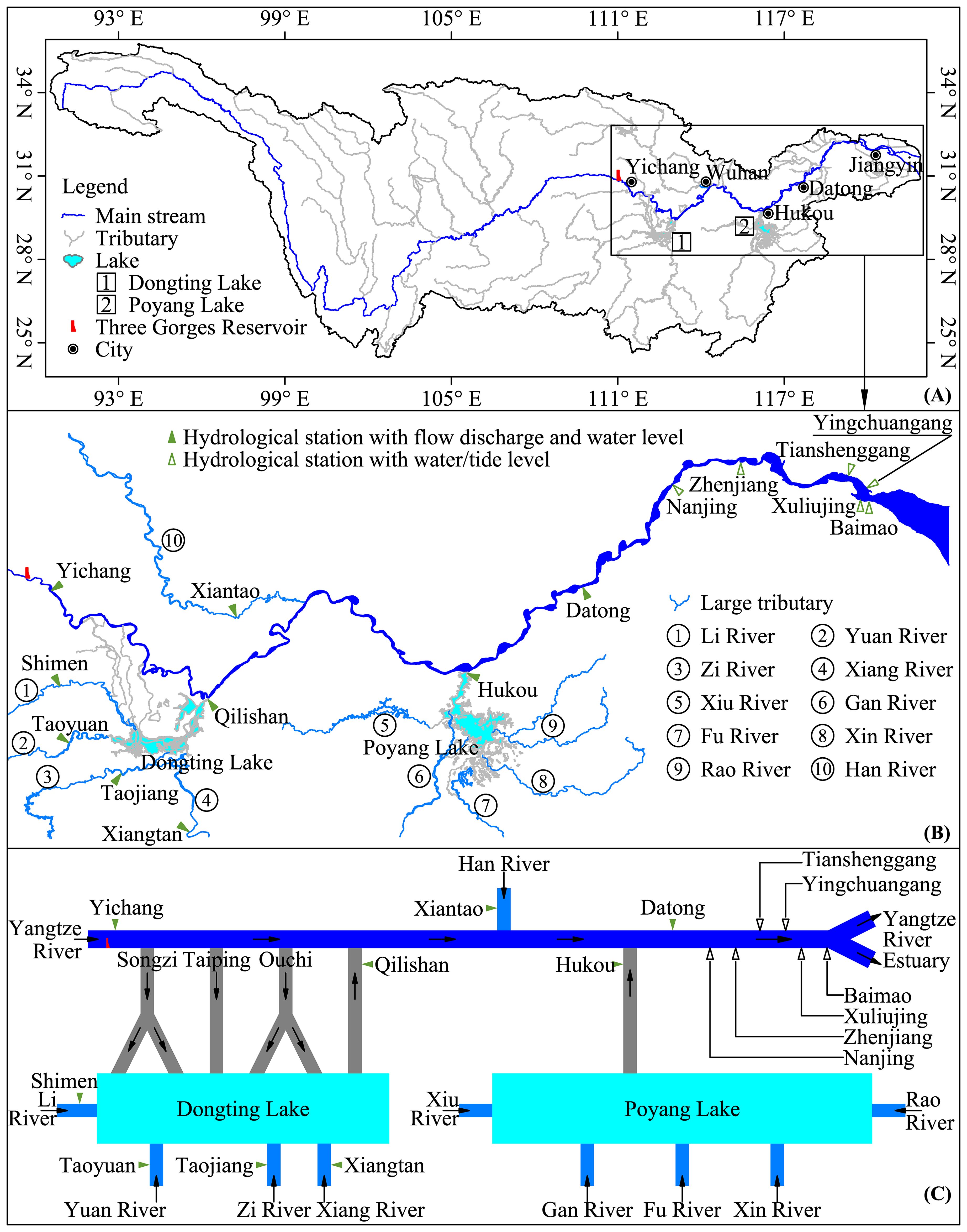
Figure 1. Study area showing (A) the Yangtze River Basin, (B) middle and lower Yangtze River, and (C) the diversion and confluence relationship between rivers and lakes.
The data used in this study were the measured and values from hydrological stations in each river (Figure 1). To analyze the impact of tides on hydrological drought in the study area, hourly tide level (Zh) data from the Nanjing, Zhenjiang, Tianshenggang, Yingchuangang, Xuliujing, and Baimao tide stations in the LYR were also collected. The data for each station are listed in Table 1.
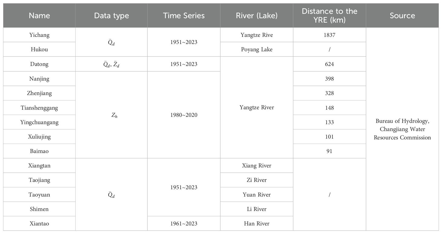
Table 1. Data of the hydrological stations utilized in this study.
Reliable data are crucial for trend and mutation tests. All data were sourced from the Bureau of Hydrology, Changjiang Water Resources Commission. These data underwent hydrological data compilation (China, 2020) before being released. Table 2 presents the reliability analysis results of the annual minimum and at Datong station. Data from all 73 years were deemed valid, with a standardized Cronbach’s alpha (Johnson, 2021) of 0.949, indicating very high reliability.
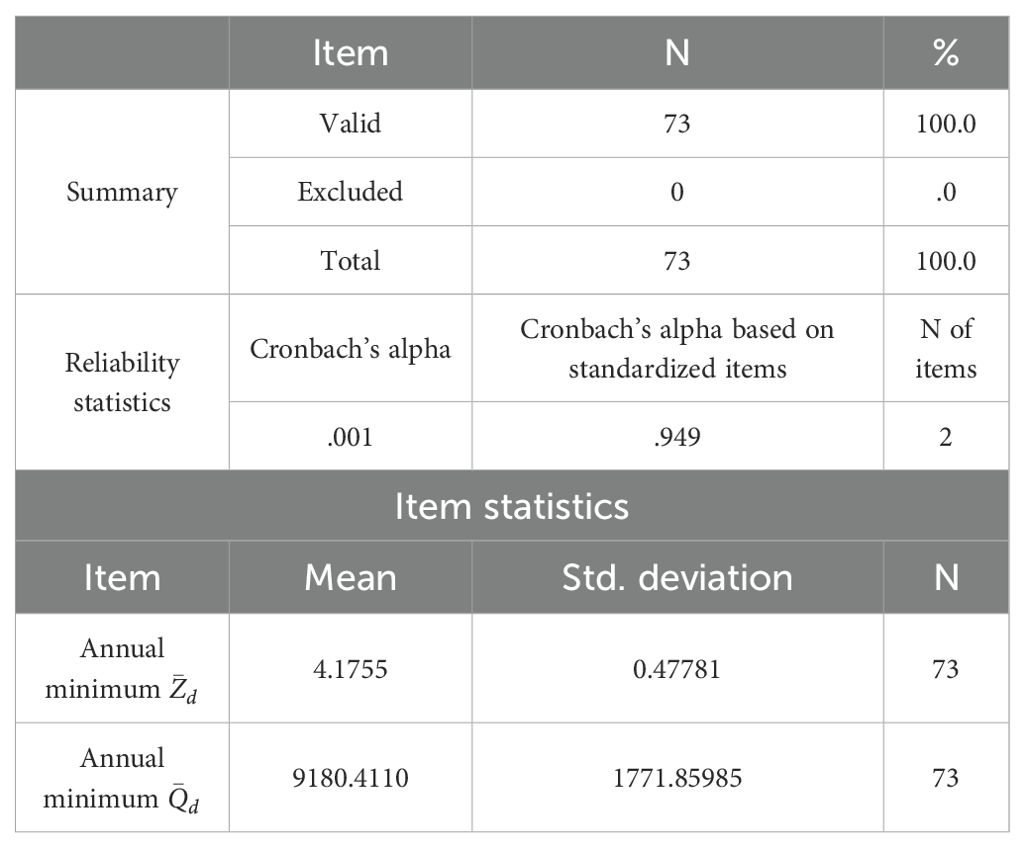
Table 2. Reliability analysis results of the annual minimum and at Datong station.
2.2 Mann–Kendall method
The Mann–Kendall method is typically used to analyze river hydrology (Du et al., 2022). This method was applied to conduct trend and mutation evaluations of hydrological droughts. We used a data series (x1, x2, …, xn) with assumed independent and random distributions. First, statistic D is calculated as follows:
where xi and xj are the observed data corresponding to the i and j time series, respectively, and . sgn is a symbolic function:
After standardizing the D value, the test statistic Z is calculated as follows:
where denotes variance. For a given significance level α, if , the original assumption is unacceptable; more specifically, there is an obvious change trend at significance level for the time series data. In this method, the p-value was inversely calculated through the . If , there is no changing trend in the sequence and vice versa. indicates an upward trend, whereas indicates a downward trend.
For mutation detection, Sk is used to represent the cumulative number of the jth sample data when :
The Sk is standardized as follows:
where is the mean of Sk and is the variance. For a given significance level , indicates an obvious change trend in all datasets. UFk can form a curve. UBk can be calculated using this method to produce an inverse sequence. At a given significance level, for example , the critical value is ±1.96. The UFk and UBk curves and ± 1.96 straight lines can be drawn in one chart. If , the dataset exhibits an upward trend, with a downward trend for . If these variables plot beyond the critical straight line, the change in the trend is significant. A zone exceeding the critical boundary was defined as the moment at which a mutation appeared. If UFk and UBk cross and the crossover point is within the critical line, the time corresponding to the intersection is the start time of the mutation.
3 Results
3.1 Trend and mutation of annual minimum values
Figure 2 shows the trend and mutation analysis results of the annual minimum and at Datong station over the past 70 years. The trend analysis results (Figures 2A, B) show that the p values of the annual minimum and were all close to 0, below the confidence level of 0.05, and the Z values were all >0, indicating that the annual minimum and exhibited an upward trend. The mutation analysis results (Figures 2C, D) reveal that there were no cross-phenomena between UB and UF within the confidence interval for the annual minimum , indicating a non-significant mutation. However, for the minimum , the UB and UF curves crossed within the confidence interval around 1989, indicating a mutation during this period.
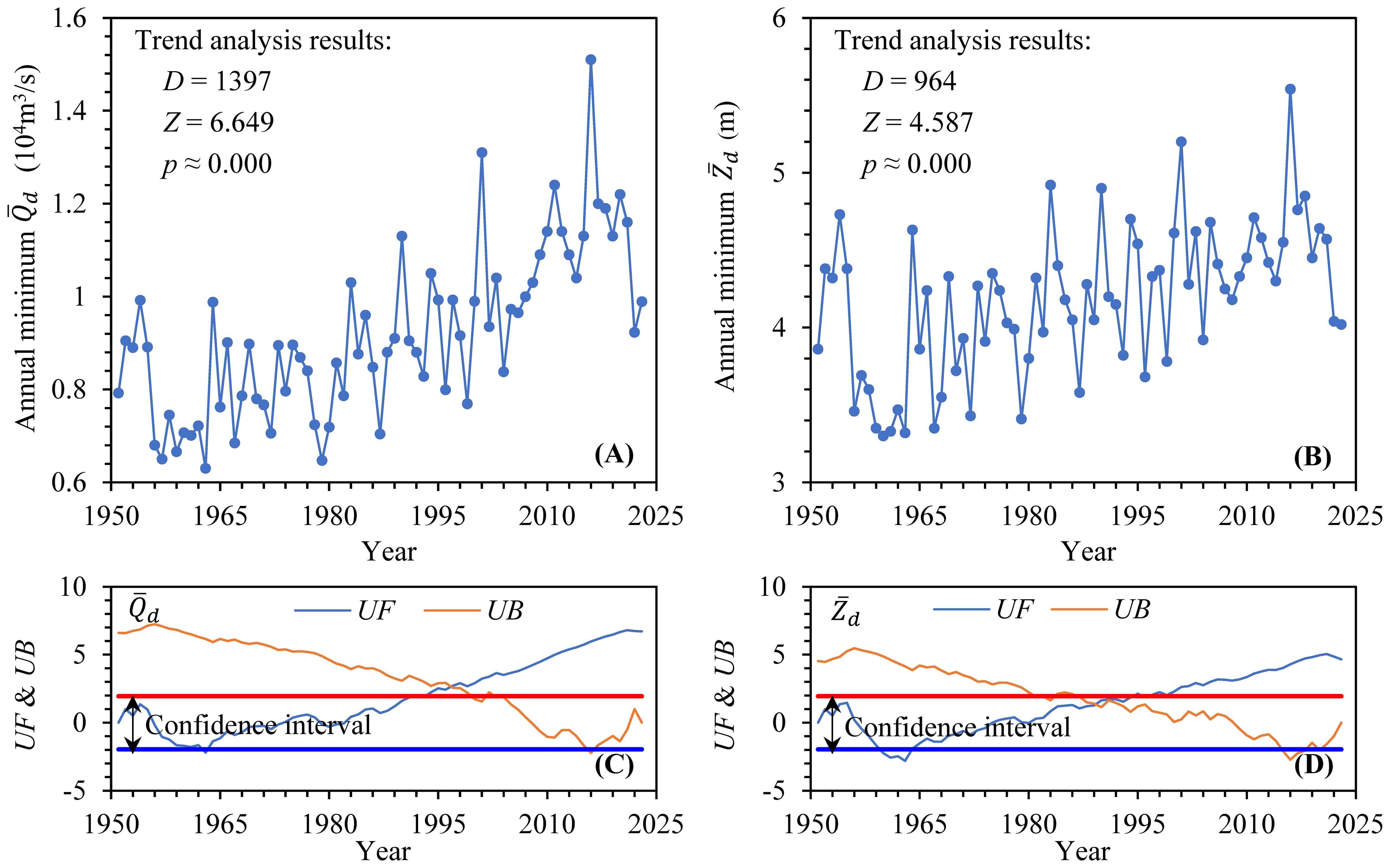
Figure 2. Trend and mutation analysis results of annual minimum values at Datong: (A) trend of , (B) trend of , (C) mutation of , and (D) mutation of .
Notably, the date of occurrence of the minimum within a year did not always correspond to that of at Datong. Figure 3 shows the statistical results of this mismatch. Since the 1950s, the number of years in which the two events occurred on different dates has increased each year (Figure 3A). In particular, since 1996, the dates on which the two occurrences appeared each year have been almost inconsistent, and their cumulative frequency has annually increased, reaching 53.4% by 2023 (Figure 3B). Figure 3C gives the number of days in which the minimum appeared behind the within the year. In rare years such as 1956, 1998, and 2011, the minimum and values appeared at the beginning and end of the year, respectively, with an interval of more than 320 days. In the past 20 years, there has been an upward trend in delayed days, with 5 years in which the delayed days exceeded 26 days and another 4 years ranging from 3 to 5 days. This result indicates that the minimum at Datong within the year was not entirely determined by the minimum but was also related to other factors.
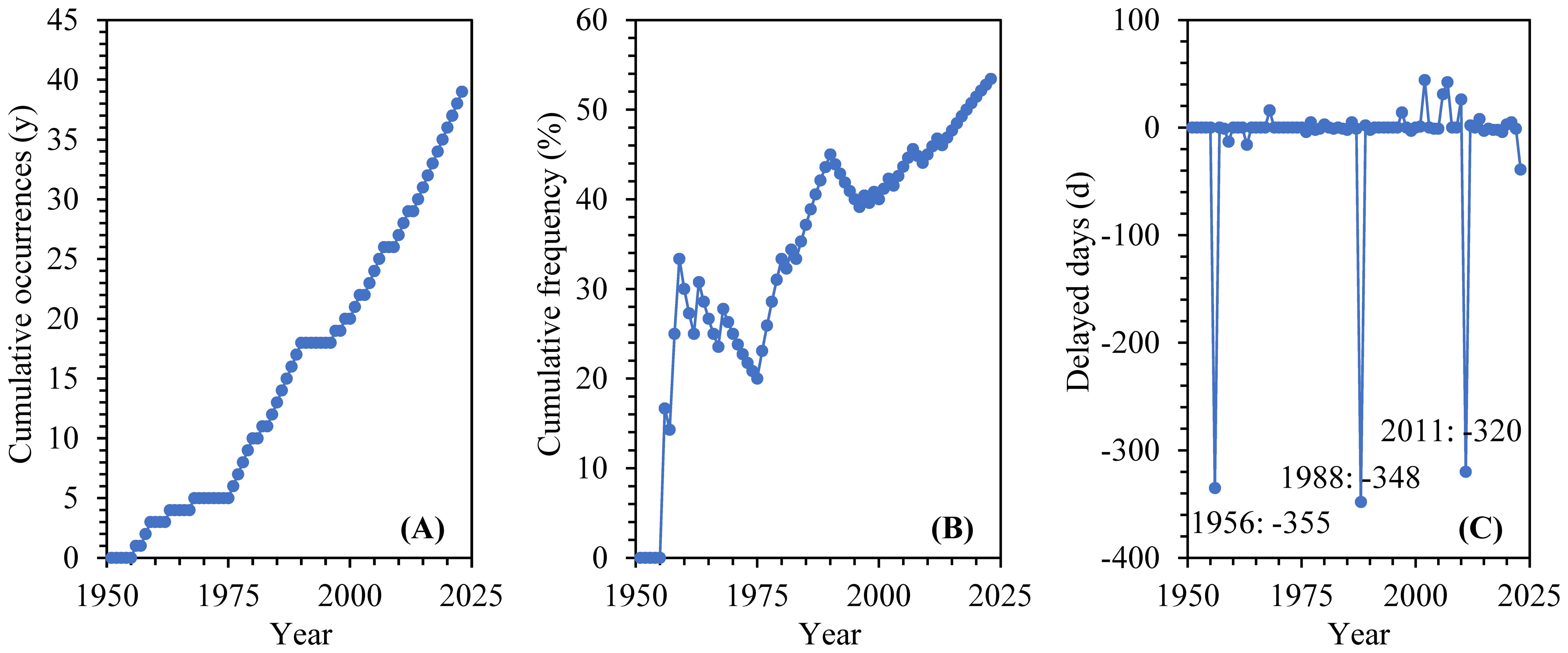
Figure 3. Inconsistency of occurrence dates for minimum and annually at Datong: (A) cumulative years of occurrence, (B) cumulative frequency of occurrence, and (C) the number of days when the minimum appears behind the .
3.2 Trend and mutation of monthly average values
Figure 4 shows the trend and mutation analysis results for the monthly average flow discharge () and water level (). Regardless of or the , the p-values from January to March before the flood season and from September to November after the flood season were all <0.05, indicating a significant trend in the and the . The D-value from January to March was >0, indicating an upward trend in these 3 months, whereas the D-value from September to November was <0, indicating a downward trend in these 3 months.
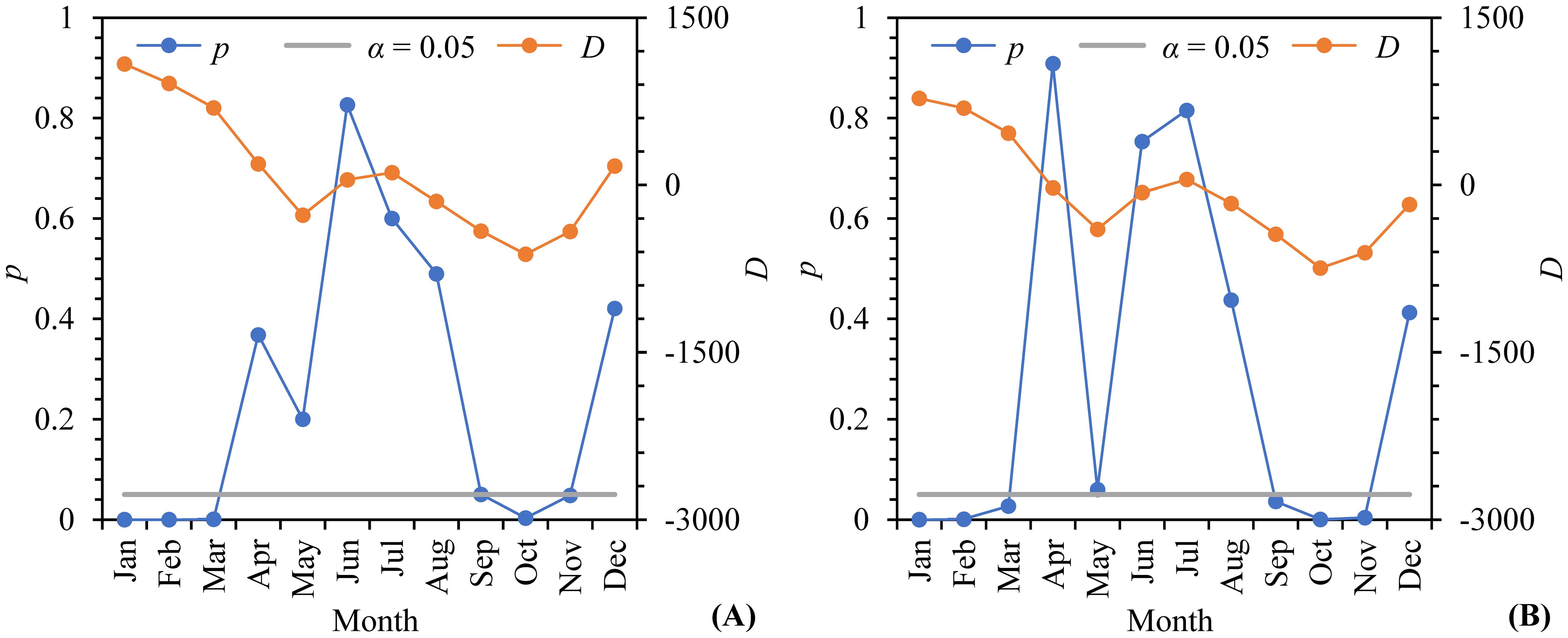
Figure 4. Trend analysis results of (A) and (B) .
The mutation analysis results (Figure 5) indicated that the UB and UF of the from January to March and from September to November both crossed within the confidence interval, indicating a mutation for . Mutations in January, February, and December occurred in the 1990s, whereas mutations in March, September, and October occurred in the 2000s. The mutation characteristics of the were similar to those of .
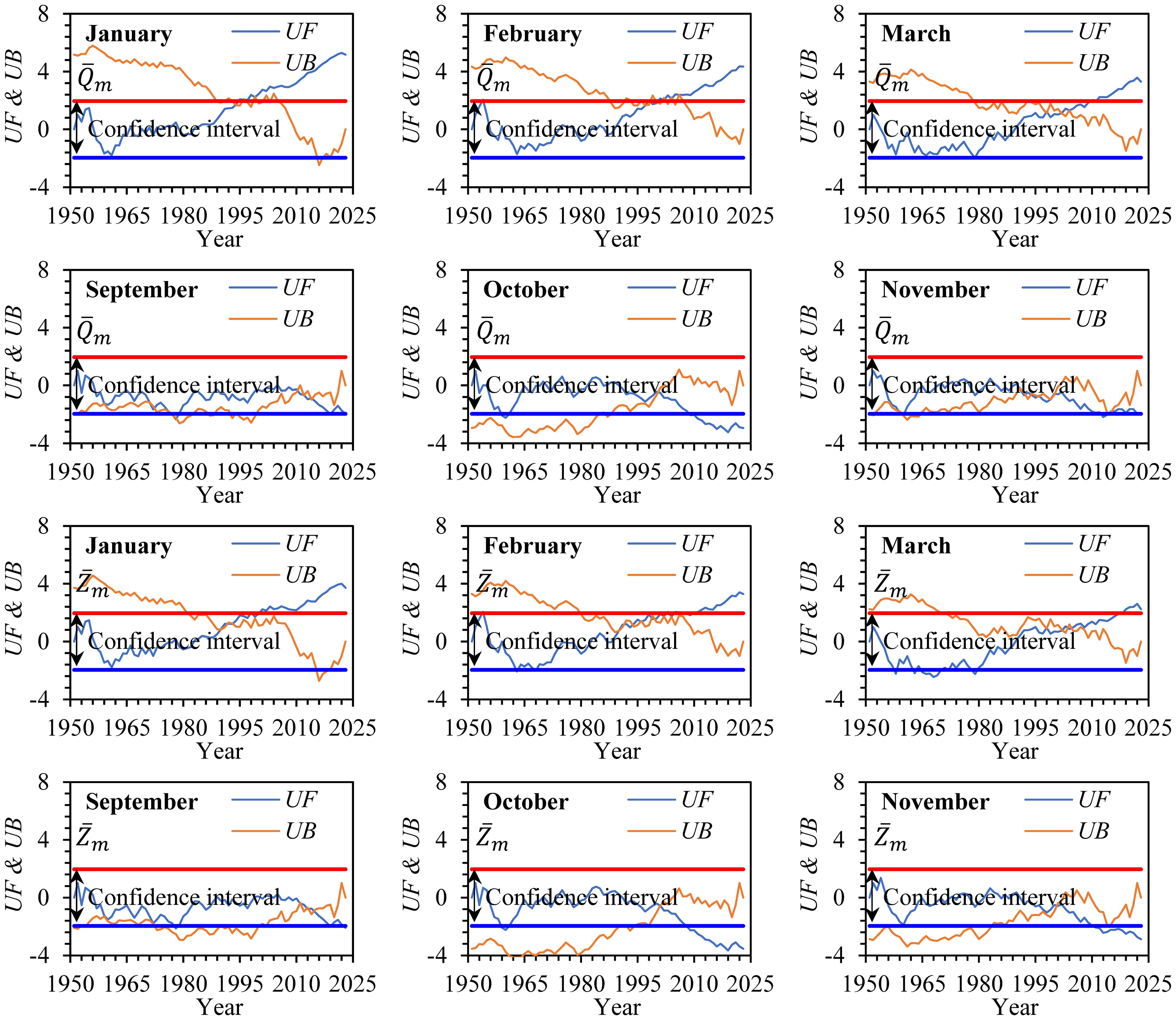
Figure 5. Mutation analysis results of and from January to March and September to November.
3.3 Extreme drought in 2022
In 2022, the YRB experienced an extreme hydrological drought from the beginning of the flood season onward. This drought can be divided into four stages (Figure 6): a pre-flood season with abundant water, an initial flood season with a rapid decline, a main flood season with a continuous decline, and a post-flood season with the driest season.
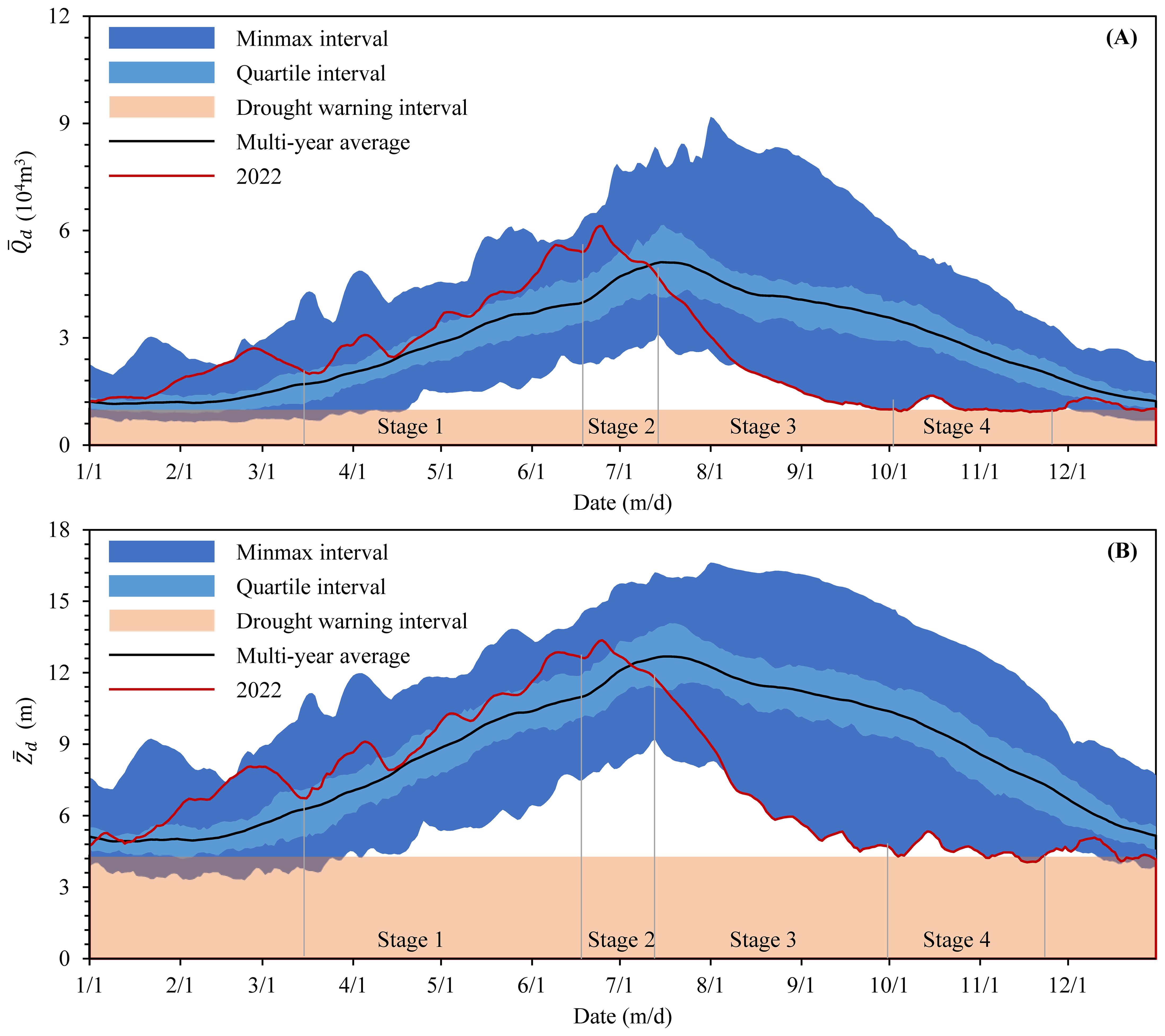
Figure 6. Comparison of (A) and (B) processes at Datong in 2022 with values recorded on the same day in history.
In stage 1 in June 2022, owing to the influence of abundant rainfall in the YRB, and at Datong began to increase in volatility at a rate significantly higher than that of the multiyear average of the same period. The average elevated amplitude of was 1.6 m, and the maximum was 2.41 m, which occurred on June 9. The annual maximum (61800 m3/s) and (13.38 m) appeared on June 24, after which the values began to decline rapidly.
In stage 2 in July, the and at Datong continued to rapidly decline, with an average daily decline of 0.11 m for , and the maximum of 0.19 m occurred on July 26. and on July 4 changed from higher to lower than the multiyear average value during the same period. Afterwards, the depressed magnitude gradually increased, from 0.12 m on July 4 to approximately 3.6 m at the end of July for , with an average depressed magnitude of approximately 1.9 m. On July 27, and at Datong dropped to 35,400 m3/s and 9.83 m, respectively, ranking the 10th lowest values in the same period. The lowest monthly values of (31,300 m3/s) and (9.06 m) that appeared on July 31 ranked the fourth lowest in recorded history.
In stage 3 in June, the average daily decline of was 0.11 m, with the largest of 0.28 m on August 5. The and in June were lower overall than the historical average, and the depressed magnitude continued to increase, from 3.6 m at the beginning of the month to 5.6 m at the end of the month for , with an average of approximately 5.0 m. On August 18, n . (19,600 m3/s) and . (6.56 m) reached the penultimate lowest values during the study period. The monthly lowest and were 15,400 m3/s and 5.65 m, respectively, which occurred on August 31. The was 0.92 m lower than the lowest value recorded in history.
In stage 4, beginning in early September, the cascade reservoirs in the UYR entered a concentrated storage period, and the and at Datong continued to decline. The lowest annual was 6,400 m3/s, which occurred on September 15. By November 16, the lowest annual was 3.91 m, which was below the drought warning level (4.3 m) for 22 days, indicating a severe hydrological drought.
Since the 1950s, the YRB has experienced multiple extreme droughts based on annual runoff, as shown in Figure 7A in 1978, 2006, 2011, 2022, and 2023. Although the annual runoff in 2022 was not the smallest, after mid-August, and in Datong were lower than those of the former typical drought years (Figures 7B, C). There were 41 days with a less than the drought warning flow discharge (10,000 m3/s); these days were mainly concentrated from October to December, with November receiving the most. Compared with previous drought years, 2022 constituted a typical post-flood drought.
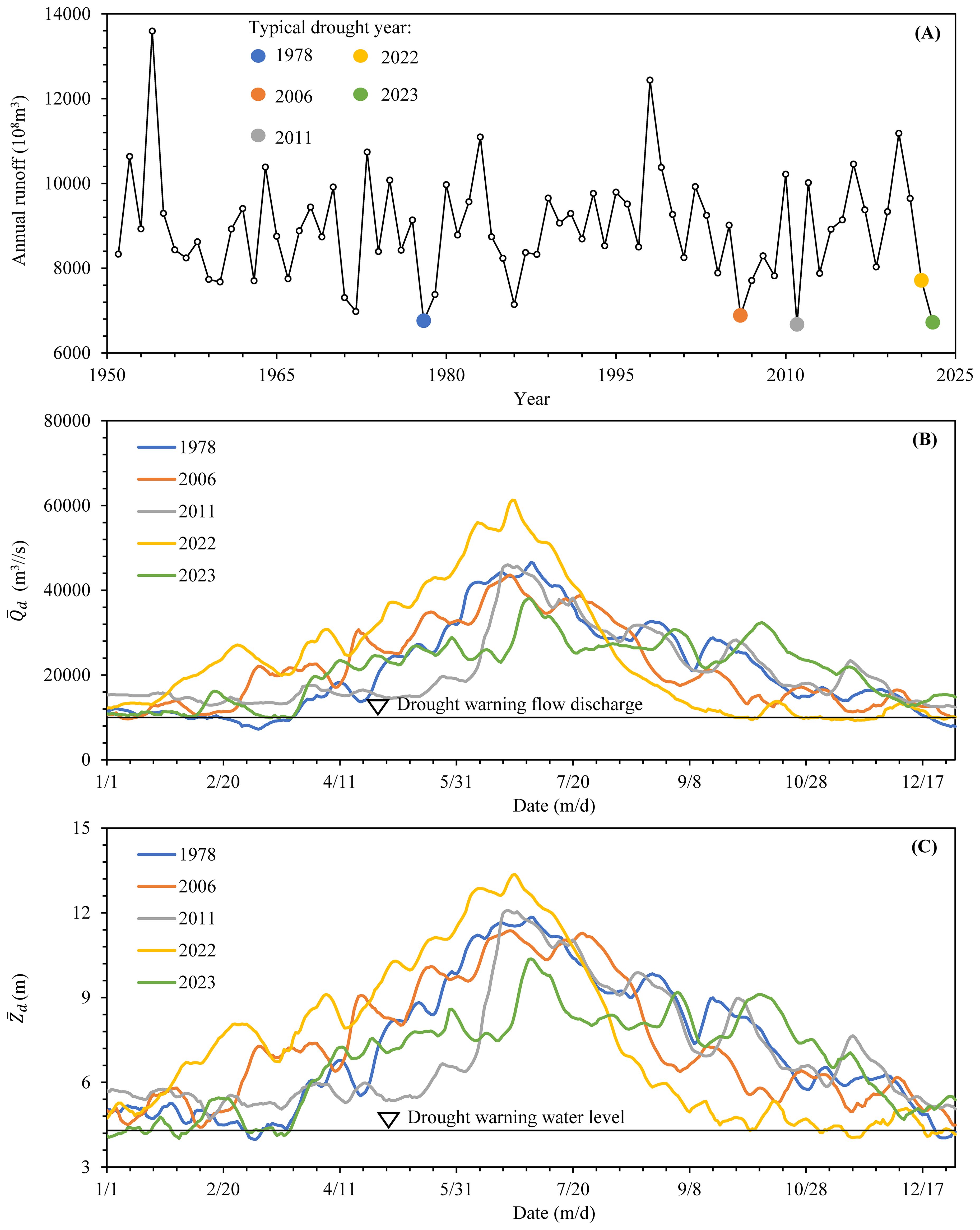
Figure 7. Comparison of the drought process at Datong between 2022 and typical historical drought years: (A) typical drought years defined by annual runoff since the 1950s, (B) comparison of , (C) comparison of .
4 Discussion
4.1 Impact of runoff
Although precipitation is a fundamental cause of drought, it is ultimately converted into runoff for specific river reaches. Figure 8 shows variations in the annual runoff composition of Datong during different historical periods. Overall, the annual runoff source was relatively stable, and the UYR and the two lake water systems consistently remained the main sources. The proportion of annual runoff from the UYR, determined at Yichang station, fluctuated between 39.6% and 59.7%, with an average of approximately 48.4%. The proportion of the total annual runoff in the two lake water systems fluctuated between 22.2% and 46.4%, with average proportions of 18.6% and 16.7% in the DTL and PYL water systems, respectively. Compared with the two periods of 2003–2010 (before the normal storage of the TGR) and 2011–2023 (after the normal storage of the TGR), the proportion of annual runoff sources at Yichang increased slightly by 0.7%, whereas that of the DTL and PYL water systems increased by 1.9%, indicating relatively small changes.
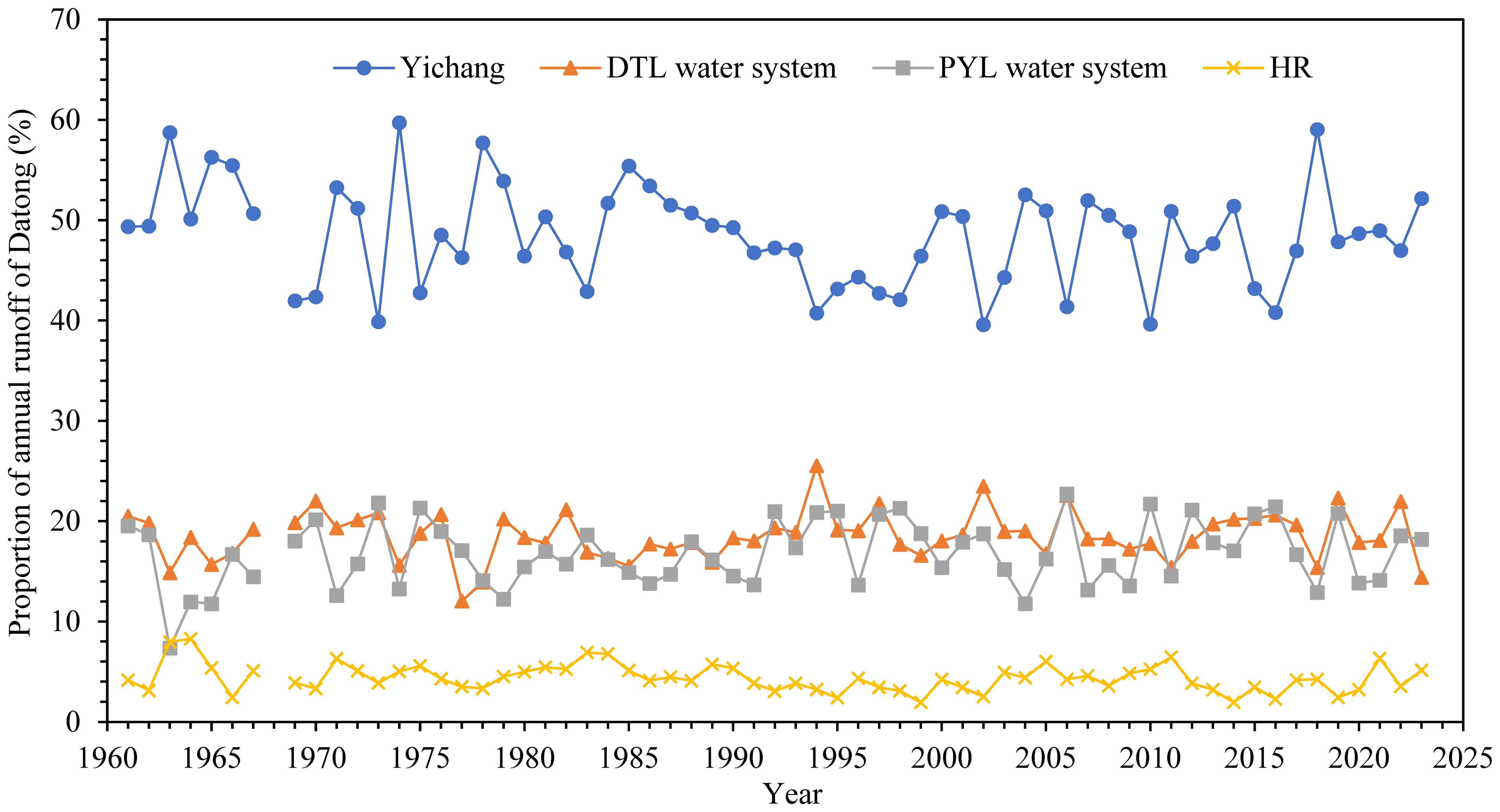
Figure 8. Sources of annual runoff at Datong since the 1960s.
Judging by the composition of different months (Figure 9), the runoff from Yichang increased significantly from January to May from 2011 to 2023, with an average increase of 27%–72% (approximately 7–8.5 billion m3) compared to runoff before 2011. This increase was even greater in February (72%). However, in September and October after the flood, runoff decreased by 24% (15.7 billion m3) and 20% (9 billion m3), respectively.

Figure 9. Composition of monthly runoff of Datong station.
Overall, although the sources of annual runoff at Datong did not change, the changes in monthly runoff within the year were more obvious, mainly because of the influence of reservoir water storage in the UYR. When the water level of the reservoir decreased before the flood season, the runoff from Yichang increased, whereas it substantively decreased after the flood season (Feng et al., 2020). Because of the longer duration of the reservoir subsidence period compared with the storage period, the trend of turning from flood to drought after the flood season was more obvious at Datong station. The storage of cascade reservoirs played an important role in the hydrological drought situation in Datong after the flood season.
Widespread drought has continued to occur in various tributaries of the basin in 2022. Figure 10 shows a comparison of the runoff composition at Datong from July to October between 2022 and the typical drought years. During this period, the runoff levels from the UYR, DTL, PYL, and HR were all significantly lower. The water volume from the UYR was close to that in 2006, whereas those in the PYL, HR, and other areas in the MYR were the lowest during these drought years. As a result, the relatively small inflow in the MYR in 2022 also substantially affected the drought conditions observed at Datong.
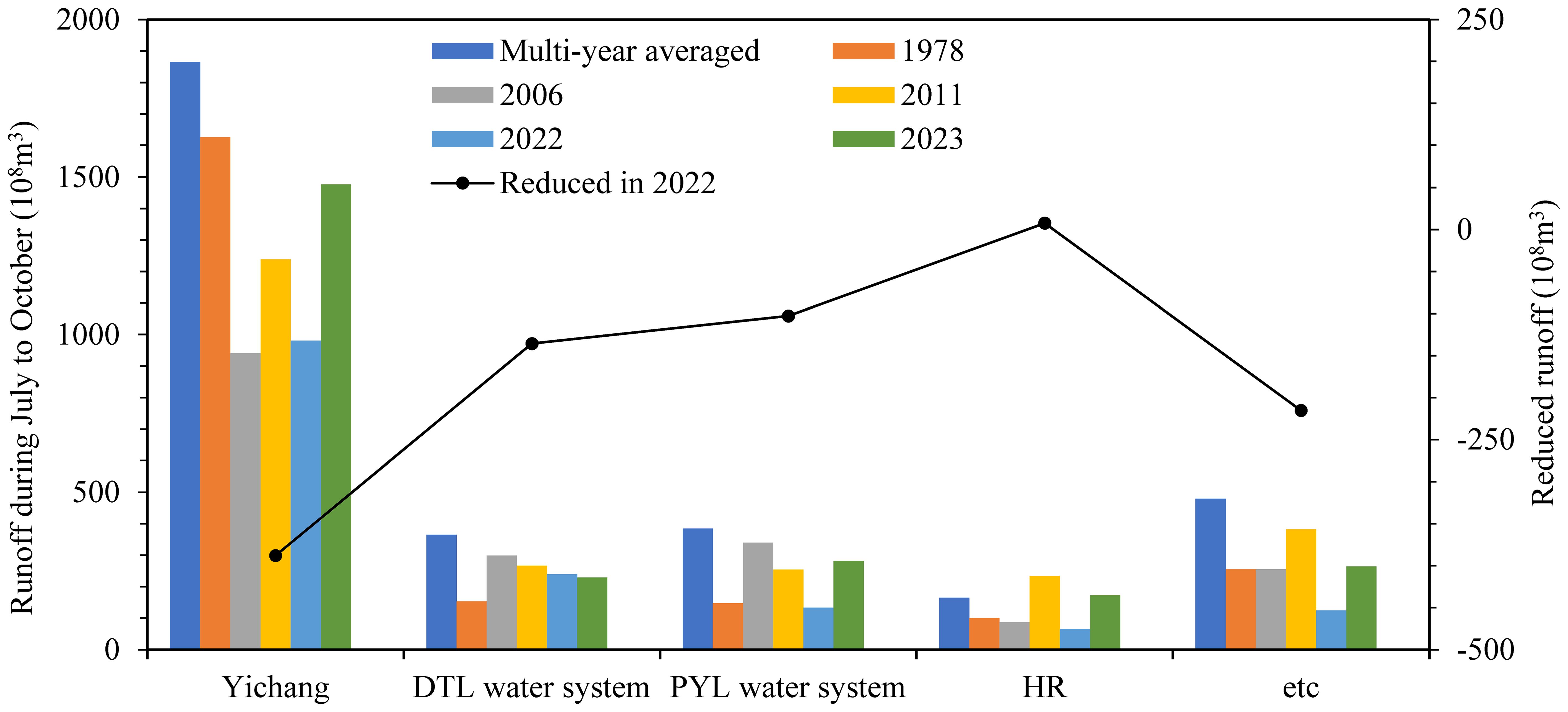
Figure 10. Comparison of the runoff sources composition at Datong from July to October between 2022 and other typical drought years.
4.2 Influence of riverbed evolution
Since the application of the TGR from 2003 to 2021, the riverbeds in the MYR and LYR have mainly eroded (Xu et al., 2023). For the tidal reach from Datong to YRE, the erosion amount for the bankfull channel (corresponding water levels for Datong and Jiangyin are 10.06 m and 2.66 m, respectively) is 18.82×10⁸ m3, of which 62.9% occurred between Datong and Jiangyin, mainly concentrated in low-water river channels, and the erosion intensity increased year by year. After a riverbed is eroded and cut down, it inevitably causes a decrease in the water level under the same inflow and tidal conditions, thereby exacerbating the hydrological drought defined by the water level. Figure 11 shows the correlation between the lowest annual at the Datong station and at the downstream Nanjing station. There is a close correlation between them, but this correlation varies in different periods. In recent decades, under the same lowest conditions at Nanjing, the lowest at Datong has slightly increased, with an amplitude of generally within 0.2 m, which has a certain buffering effect on drought conditions. Although the erosion amplitude of the riverbed in the LYR is not yet severe, in future years, with the continuous operation of cascade reservoirs in the UYR, the riverbed in the LYR will inevitably suffer more severe erosion (Hu et al., 2023), and a further increase in the erosion amplitude will exacerbate the water level decrease at the Datong station. Therefore, future drought trends in the LYR will inevitably be affected by riverbed cutting and should receive sufficient attention.
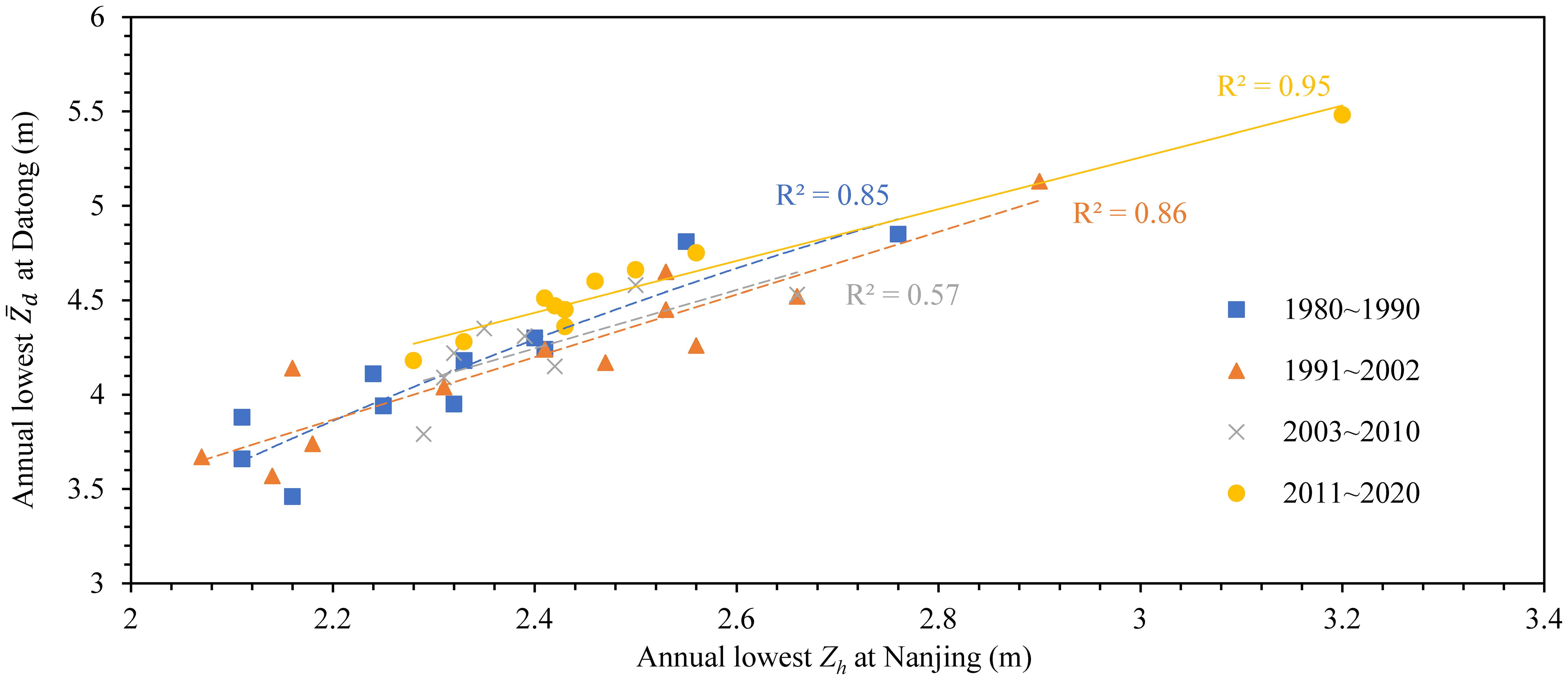
Figure 11. Correlation of the lowest water level between Datong and Nanjing stations.
The downcutting of the riverbed can also cause a decrease in at the same . Figure 12 shows the changes in the relationship between and at Datong station over the past 20 years. It can be seen that the relationship has been relatively stable, but the still slightly decreases when the is <40,000 m3/s, and the bigger the , the smaller drop of the . When the are 15,000 m3/s, 25,000 m3/s, and 35,000 m3/s, compared to 2001, the drops in 2021 are 0.36 m, 0.28 m, and 0.16 m, respectively. When the further increases, the remains basically unchanged. This is consistent with the above-mentioned riverbed erosion law, that is, erosion is mainly concentrated in low-water river channels. As a result, decline is also mainly concentrated in smaller .
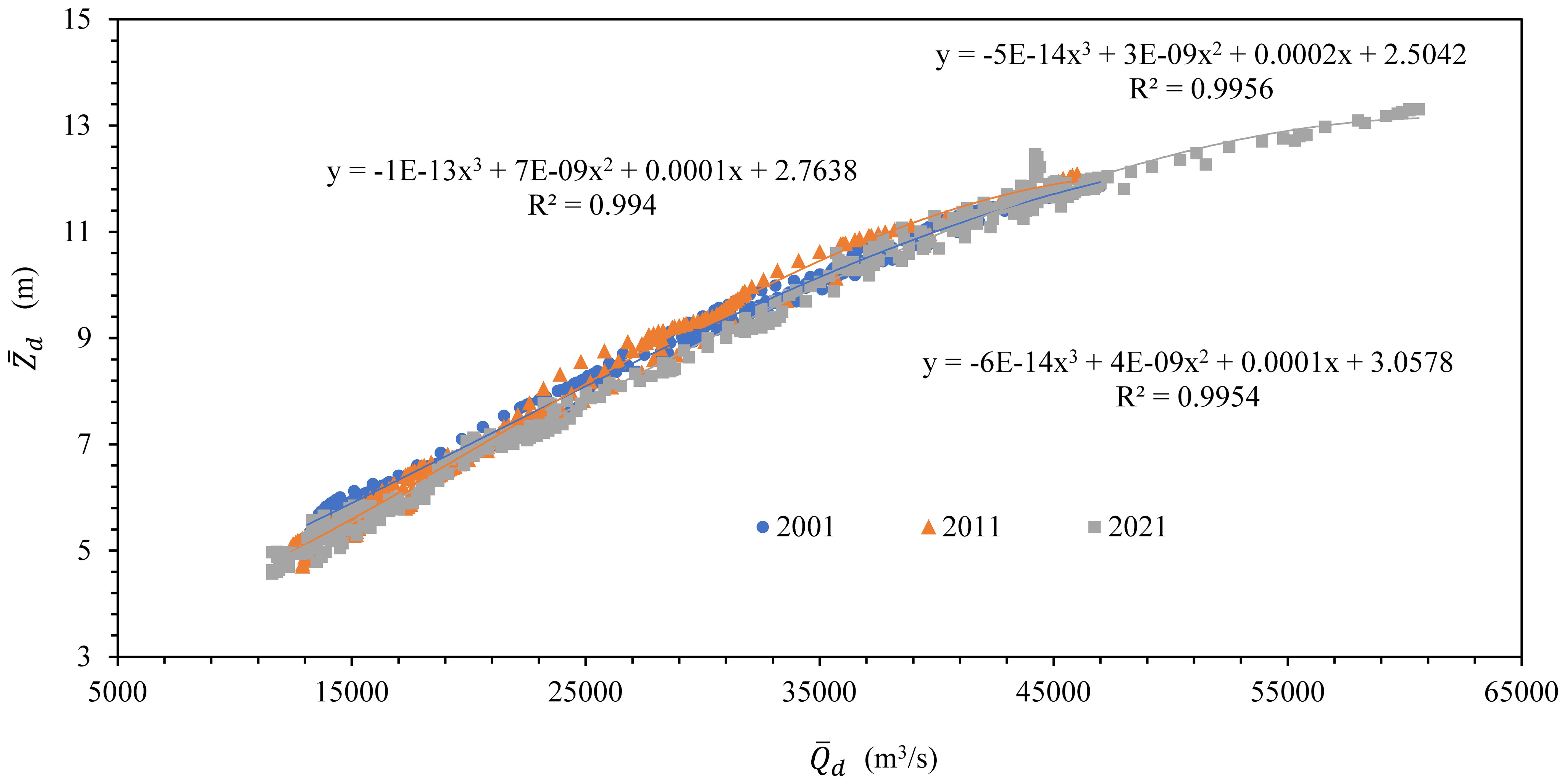
Figure 12. The relationship between and at Datong station in recent 20 years.
4.3 Effect of tide currents
Tidal reach is affected by both the input runoff from the upstream river and downstream tidal currents. The tidal level at the Baimao hydrological station, located at the entrance of the YRE, was selected to analyze the effects of tidal currents. Figure 13 shows the correlation between the characteristic Zh at the Baimao station and those distributed along the LYR from 2010 to 2020. A close linear correlation exists between Baimao and other stations in the LYR for the annual average low Zh (Figure 13A). Except for the correlation coefficient with Tianshenggang, which was 0.61, the linear correlation coefficients with the other stations were above 0.9. This result indicates that, on average, low Zh in the YRE will have a significant impact on hydrological drought in the LYR. However, for the lowest annual Zh, the correlation between Baimao and the stations in the LYR above Xuliujing was extremely low, with a linear correlation coefficient generally within 0.2 as shown in Figure 13B. In summary, the extremely low Zh in the YRE had a relatively small impact on the overall extreme drought in the LYR. Therefore, although the average low Zh had an impact on drought in the LYR, because the downstream low Zh is not controllable by human activities, future research on the impact of downstream tidal currents on droughts in the LYR should be conducted from a global climate perspective.
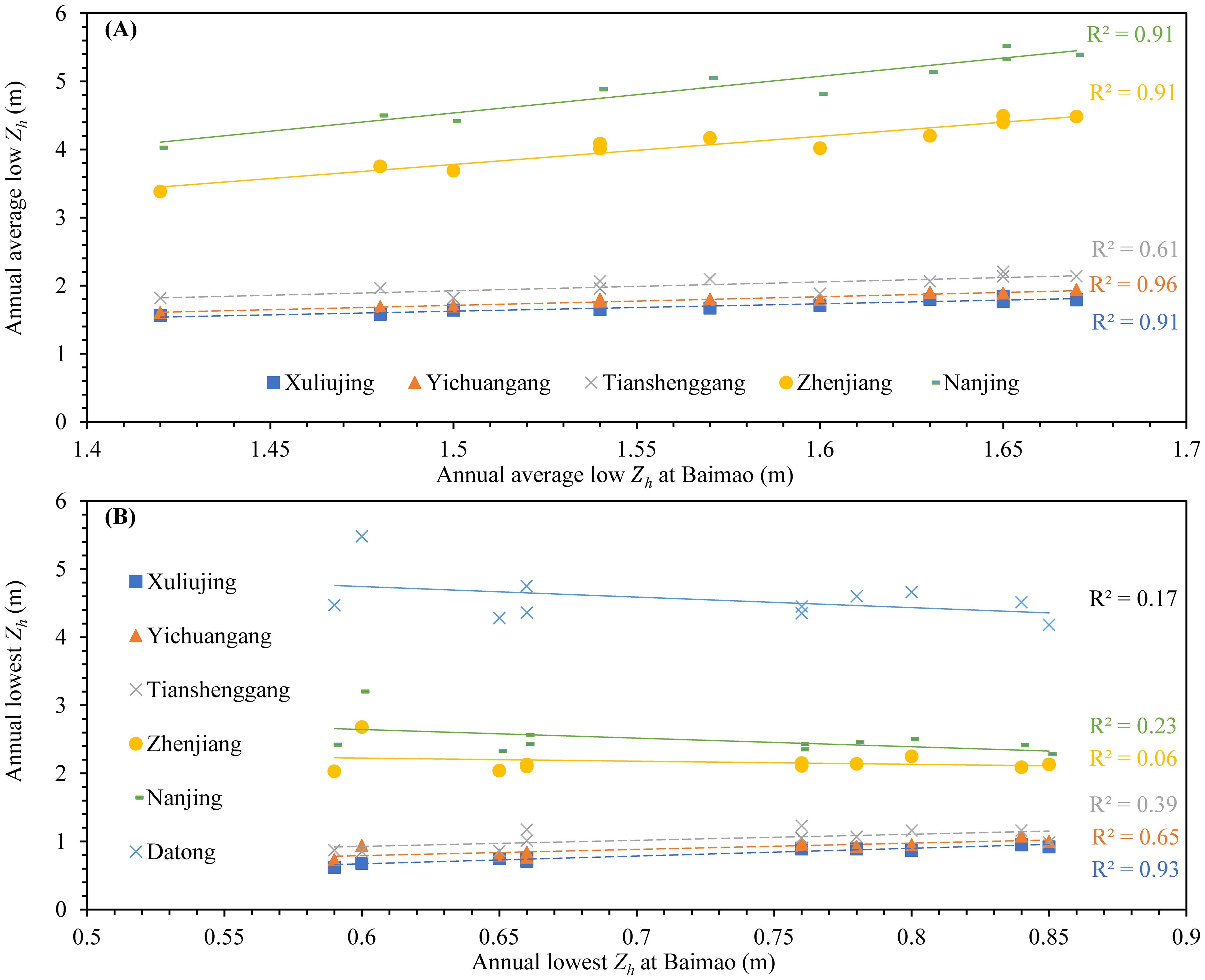
Figure 13. Correlation of the characteristic Zh between the stations along the LYR: (A) annual average low Zh and (B) annual lowest Zh.
4.4 Impact of drought on water intake and shipping
The water intake in tidal river sections is not only affected by the lowest but also the . This is because the main purpose of water intake is to utilize freshwater resources, and when the is low, saltwater intrusion is extremely detrimental to the acquisition of freshwater resources. In recent years, under the comprehensive influence of continuous erosion of the riverbed and the replenishment scheduling of the TGR during the dry season, the frequency of extremely low at Datong station has decreased, and the extremely low , has been raised. Therefore, for general dry water conditions, the impact of riverbed cutting is greater than the replenishment effect of reservoirs, especially since 2020, in the flow range of 11,000–25,000 m3/s, under the same inflow , the measured average and minimum have both decreased by approximately 0.35 m.
Considering the relationship shown in Figures 11, 12, the was found to decrease by 0.22 m for every 1,000 m3/s decrease in at Datong station, and the low Zh at Nanjing station decreased by 0.53 m for every 1 m decrease in , approaching a ratio of 2:1. To maintain the low Zh of Nanjing station with a 95%–99% guarantee rate without decreasing, the of Datong station needs to gradually increase from 10,000 m3/s to 12,500 m3/s. To ensure the safe operation of the existing water intake project and maintain the Zh at Nanjing station above 2.3 m, the minimum of Datong should be increased to 11,300 m3/s.
The continuous decline in caused by hydrological drought will deteriorate the navigation environment, which will significantly impact shipping. The narrowing of the waterway after decreases will make it difficult for ships to rendezvous and overtake. Due to limitations, cargo ship loads will need to decrease to meet these navigation conditions. In addition, the rapid drop in after the flood season can also make it difficult to maintain the corresponding depth of the sea vessel channel, leading to closures and reduced shipping efficiency.
5 Conclusions
Based on an over 70-year dataset, we analyzed the hydrological drought situation and its causes in the lower reaches of the Yangtze River using the Mann–Kendall method. The conclusions are as follows.
1. Both the annual minimum flow discharge and water level at Datong station showed an upward trend over the past 73 years. There was no mutation in the annual minimum flow discharge, but the mutation for annual minimum water level occurred around 1989. The dates on which these two events occurred each year have almost remained inconsistent since 1996, exhibiting as a delayed water level behind flow discharge and even appearing at the beginning and end of the year, respectively.
2. For both monthly average flow discharge and water level, there was a clear upward trend from January to March before the flood season and a downward trend from September to November after the flood season. For both variables, changes observed in January, February, and December occurred in the 1990s, whereas those in March, September, and October occurred in the 2000s.
3. The extreme drought in 2022 showed four distinct stages, with a rapid decline in the water situation during the initial flood season, which started the prelude to drought. The continuous decline during the flood season and the storage of reservoirs after the flood season caused 2022 to be the most severe drought period in nearly 70 years. In the future, the joint operation of cascade reservoirs can alleviate the hydrological drought more effectively in the lower reaches of the Yangtze River under extreme weather conditions. Further research to determine optimal strategies for achieving this goal is required.
4. Although the source of annual runoff in the lower reaches of the Yangtze River has not changed, the rapid storage of reservoirs after floods intensified the trend of the lower reaches of the Yangtze River from flooding to drought and promoted hydrological drought. Lower runoff from the DTL, Poyang Lake, and HR also promoted extreme drought in the lower reaches of the Yangtze River in 2022.
5. Presently, the impact of slight riverbed erosion on drought in the lower reaches of the Yangtze River is not significant. With the continuous operation of reservoirs in the upper reaches of the Yangtze River in future years, continued riverbed erosion is expected to exacerbate hydrological drought in this region. Further research should focus on the impact of riverbed cutting, and research considering global climate change is required to determine the impacts of future tide level changes on drought conditions in lower reaches of the Yangtze River.
Data availability statement
The original contributions presented in the study are included in the article/supplementary material. Further inquiries can be directed to the corresponding author.
Author contributions
HG: Conceptualization, Data curation, Formal analysis, Funding acquisition, Writing – original draft, Writing – review & editing. LZ: Formal analysis, Investigation, Methodology, Supervision, Validation, Writing – original draft, Writing – review & editing. BM: Formal analysis, Resources, Visualization, Writing – review & editing.
Funding
The author(s) declare financial support was received for the research, authorship, and/or publication of this article. This research was funded by the National Key Research and Development Program of China (grant number 2022YFC3202602) and National Natural Science Foundation of China (grant number U2240224).
Conflict of interest
The authors declare that the research was conducted in the absence of any commercial or financial relationships that could be construed as a potential conflict of interest.
Generative AI statement
The author(s) declare that no Generative AI was used in the creation of this manuscript.
Publisher’s note
All claims expressed in this article are solely those of the authors and do not necessarily represent those of their affiliated organizations, or those of the publisher, the editors and the reviewers. Any product that may be evaluated in this article, or claim that may be made by its manufacturer, is not guaranteed or endorsed by the publisher.
References
Cao R., Li S., Xing L., Zhu W., Gong W., Shen Z. (2023). Reservoir impounding strategies of cascade reservoirs under extreme low-flow conditions.Case study of lower Jinsha River and Three Gorges cascade reservoirs. J. Hydroelectric Eng. 42, 1–12. doi: 10.11660/slfdxb.20230601
Chai Y. F., Li Y. T., Yang Y. P., Li S. X., Zhang W., Ren J. Q., et al. (2019). Water level variation characteristics under the impacts of extreme drought and the operation of the Three Gorges Dam. Front. Earth Sci. 13, 510–522. doi: 10.1007/s11707-018-0739-3
Chakraborty P., Jayachandran S., Lekshmy J., Padalkar P., Sitlhou L., Chennuri K., et al. (2019). Seawater intrusion and resuspension of surface sediment control mercury (Hg) distribution and its bioavailability in water column of a monsoonal estuarine system. Sci. Total Environ. 660, 1441–1448. doi: 10.1016/j.scitotenv.2018.12.477
da Costa A. K. R., Pereira L. C. C., Jiménez J. A., de Oliveira A. R. G., Flores-Montes M. D., da Costa R. M. (2022). Effects of extreme climatic events on the hydrological parameters of the estuarine waters of the amazon coast. Estuaries Coasts 45, 1517–1533. doi: 10.1007/s12237-022-01056-y
Ding S., Niu W., Zhang H. (2023). Study on joint operation scheme of reservoirs in upper reaches of Yangtze River for low water in 2022. Yangtze River 54, 1–6. doi: 10.16232/j.cnki.1001-4179.2023.02.001
Du P., Ye W.-J., Deng B.-P., Mao M., Zhu Y.-L., Cheng F.-P., et al. (2022). Long-term changes in zooplankton in the Changjiang estuary from the 1960s to 2020. Front. Mar. Sci. 9. doi: 10.3389/fmars.2022.961591
Feng R., Rong Y., Yin Y. (2020). Influence of Three Gorges Dam construction on runoff distribution in the upper reaches of the Yangtze River. J. Beijing Normal University(Natural Science) 56, 334–342. doi: 10.12202/j.0476-0301.2020167
Feng B., Zhang T., Zeng M. (2018). Analysis on low flow in middle and lower Yangtze River in Autumn 2016 and its enlightenment to co-regulation of reservoir group. Yangtze River 49, 9–13. doi: 10.16232/j.cnki.1001-4179.2018.11.003
Ge H., Zhu L. L., Long R., Deng C. Y., Yin S. R., Zhang O. Y. (2022). Spatial and temporal evolution characteristics of low water level based on 70 years’ Measured data: A case study of Dongting Lake in China. Front. Earth Sci. 10. doi: 10.3389/feart.2022.933568
Guan X., Zeng M. (2022). Characteristics and enlightenment of low water in Changjiang River Basin in 2022. Yangtze River 53, 1–5 + 36. doi: 10.16232/j.cnki.1001-4179.2022.12.001
Hu C., Fang C., Shi H. (2023). Recent progress in sediment research of the Three Gorges Project. China Water Resour. 19), 10–16. doi: 10.3969/j.issn.1000-1123.2023.19.004
Hua X., Huang H. M., Wang Y. G., Yu X., Zhao K., Chen D. K. (2020). Seasonal estuarine turbidity maximum under strong tidal dynamics: three-year observations in the Changjiang river estuary. Water 12, 18. doi: 10.3390/w12071854
Jin J., Xiao Y., Jin J., Zhu Q., Yyong B., Ji Y. (2021). Spatial-temporal variabilities of the contrasting hydrometeorological extremes and the impacts on vegetation growth over the Yangtze River basin. Adv. Water Sci. 32, 867–876. doi: 10.14042/j.cnki.32.1309.2021.06.006
Johnson E. (2021). “Cronbach’s alpha,” in Encyclopedia of Autism Spectrum Disorders. Ed. Volkmar F. R. (Springer International Publishing, Cham), 1248–1249.
Ke S., Ding B., Qu G. (2023). Research on the impact and countermeasures of low water conditions on the operation of water extraction projects in the middle and lower reaches of the Yangtze River. China Flood Drought Manage. 33, 25–30. doi: 10.16867/j.issn.1673-9264.2023290
Kumar S., Lawrence D. M., Dirmeyer P. A., Sheffield J. (2014). Less reliable water availability in the 21st century climate projections. Earths Future 2, 152–160. doi: 10.1002/2013ef000159
Lai X. J., Jiang J. H., Yang G. S., Lu X. X. (2014). Should the Three Gorges Dam be blamed for the extremely low water levels in the middle-lower Yangtze River? Hydrological Processes 28, 150–160. doi: 10.1002/hyp.10077
Lai G., Zhang Z., Wang P., Wu Q., Pan S., Hu X., et al. (2017). Simulation of impacts of Poyang Lake Hydraulic Project on the flow of the Yangtze River using an EFDC model. J. Lake Sci. 29, 521–533. doi: 10.18307/2017.0301
Lei S., Shi S., Qu Y., Liu Y., Liao J., Zhang Y., et al. (2023). Characteristics of extreme drought in the Poyang Lake Basin in 2022 and implications for future response. J. Hydraulic Eng. 54, 333–346. doi: 10.13243/j.cnki.slxb.20220925
Liang M. L., Yuan X., Zhou S. Y., Ma Z. S. (2023). Spatiotemporal evolution and nowcasting of the 2022 Yangtze River mega-flash drought. Water 15, 14. doi: 10.3390/w15152744
Linsley J. R. K., Kohler M. A., Paulhus J. L. (1975). Hydrology for engineers (New York: McGraw-Hill).
Liu C., Xiao Y., Yu M., Chen X., Xi S., Zhang B. (2024). Seasonal differences in the impacts of human activities on river-tidal dynamics in the Pearl River Networks in recent two decades. Eng. J. Wuhan Univ. 57, 1–10. doi: 10.14188/j.1671-8844.2024-01-001
Liu Z. C., Zhou W. (2021). The 2019 autumn hot drought over the middle-lower reaches of the Yangtze River in China: early propagation, process evolution, and concurrence. J. Geophysical Research-Atmospheres 126, 21. doi: 10.1029/2020jd033742
Lyu Z. Z., Gao H., Gao R., Ding T. (2023). Extreme characteristics and causes of the drought event in the whole Yangtze River Basin in the midsummer of 2022. Adv. Climate Change Res. 14, 642–650. doi: 10.1016/j.accre.2023.09.007
Mei X. F., Dai Z. J., Du J. Z., Darby S. E. (2023). Mega dam-induced riverbed erosion exacerbates drought effects on river water surface elevation. Hydrological Processes 37, 13. doi: 10.1002/hyp.14917
Mo S., Zhong Y., Forootan E., Shi X., Feng W., Yin X., et al. (2022). Hydrological droughts of 2017–2018 explained by the Bayesian reconstruction of GRACE(-FO) fields. Water Resour. Res. 58, e2022WR031997. doi: 10.1029/2022WR031997
Ouyang s., Xu C., Shao J., Hu F. (2023). Preliminary study on water storage situation of cascade reservoirs in the upstream of Yangtze River under drought conditions. J. Yangtze River Sci. Res. Institute 40, 15–22. doi: 10.11988/ckyyb.20221681
Rahiz M., New M. (2013). 21st century drought scenarios for the UK. Water Resour. Manage. 27, 1039–1061. doi: 10.1007/s11269-012-0183-1
Ran X., Liu J., Yu Z., Yao Q., Guo H., Chen H. (2017). Distribution, transport and retention of silica in the main channels of the Yangtze River in exceptionally low water discharge year. J. Lake Sci. 29, 740–752. doi: 10.18307/2017.0324
Ran Y. H., Zhong M., Chen W., Zhong Y. L., Feng W. (2021). Monitoring the extreme drought in the middle and lower reaches of the Yangtze River in 2019 from GRACE-FO satellites. Chin. Sci. Bulletin-Chinese 66, 107–117. doi: 10.1360/tb-2020-0375
Seager R., Ting M. F., Alexander P., Nakamura J., Liu H. B., Li C. H., et al. (2022). Mechanisms of a meteorological drought onset: summer 2020 to spring 2021 in southwestern North America. J. Climate 35, 3767–3785. doi: 10.1175/jcli-d-22-0314.1
Sebastiá M. T., Rodilla M., Falco S., Sanchis J. A. (2013). Analysis of the effects of wet and dry seasons on a Mediterranean river basin: Consequences for coastal waters and its quality management. Ocean Coast. Manage. 78, 45–55. doi: 10.1016/j.ocecoaman.2013.03.012
Shan L. J., Zhang L. P., Song J. Y., Zhang Y. J., She D. X., Xia J. (2018). Characteristics of dry-wet abrupt alternation events in the middle and lower reaches of the Yangtze River Basin and the relationship with ENSO. J. Geographical Sci. 28, 1039–1058. doi: 10.1007/s11442-018-1540-7
Shang N. A., Wang C., Kong J. J., Yu H. Y., Li J. H., Hao W. Y., et al. (2023). Dissolved polycyclic aromatic hydrocarbons (PAHs-d) in response to hydrology variation and anthropogenic activities in the Yangtze River, China. J. Environ. Manage. 326, 10. doi: 10.1016/j.jenvman.2022.116673
Shen B. Z., Zhang S. X., Yang H. W., Wang K., Feng G. L. (2012). Analysis of characteristics of a sharp turn from drought to flood in the middle and lower reaches of the Yangtze River in spring and summer in 2011. Acta Physica Sin. 61, 11. doi: 10.7498/aps.61.109202
Tian J. X., Chang J., Zhang Z. X., Wang Y. J., Wu Y. X., Jiang T. (2019). Influence of three gorges dam on downstream low flow. Water 11, 16. doi: 10.3390/w11010065
Townsend S. A., Douglas M. M. (2017). Discharge-driven flood and seasonal patterns of phytoplankton biomass and composition of an Australian tropical savannah river. Hydrobiologia 794, 203–221. doi: 10.1007/s10750-017-3094-6
Wang X. Y., Sun J. W., Zhao Z. H. (2020). Effects of river discharge and tidal meandering on morphological changes in a meso tidal creek. Estuar. Coast. Shelf Sci. 234, 10. doi: 10.1016/j.ecss.2020.106635
Wang W., Zhu Y., Xu R., Liu J. (2015). Drought severity change in China during 1961–2012 indicated by SPI and SPEI. Natural Hazards 75, 2437–2451. doi: 10.1007/s11069-014-1436-5
Wu Z. W., Li J. P., He J. H., Jiang Z. H. (2006). Large-scale atmospheric singularities and summer long-cycle droughts-floods abrupt alternation in the middle and lower reaches of the Yangtze River. Chin. Sci. Bull. 51, 2027–2034. doi: 10.1007/s11434-006-2060-x
Wu C., Tian B., Gao P., Mu X., Zhao G., Yin D. (2021). Characteristics and driving factors of water area change of Poyang Lake during dry season in recent 40 years. J. Soil Water Conserv. 35, 177–184 + 189. doi: 10.13870/j.cnki.stbcxb.2021.03.025
Xia J., Li X., Yao J., Zhou M., Deng S. (2021). Low-water channel adjustment in middle Yangtze River after operation of Three Gorges Project and its effect on navigation. J. Hydroelectric Eng. 40, 1–11. doi: 10.11660/slfdxb.20210201
Xiao Z., Zhu S., Luo X., Lou L., Li J., Luo S., et al. (2021). Multi-scale hydrological drought characteristics and vegetation responses in the Three-River-Source Region. J. Hohai Univ. (Natural Sciences) 49, 515–520. doi: 10.3876/j.issn.1000.1980.2021.06.005
Xie R. R., Pang Y., Luo B. R., Li J. B., Wu C. S., Zheng Y. Y., et al. (2017). Spatiotemporal variability in salinity and hydraulic relationship with salt intrusion in the tidal reaches of the Minjiang River, Fujian Province, China. Environ. Sci. pollut. Res. 24, 11847–11855. doi: 10.1007/s11356-017-8788-9
Xiong B., Zhuo Y., Xu C., Xiong L., Chen Z., Tian Y. (2024). Analysis on the evolution and driving mechanism of low flow regime from 1956 to 2022 in Poyang Lake,China. J. Hydraulic Eng. 55, 1–13. doi: 10.13243/j.cnki.slxb.20230329
Xu Q., Dong B., Yuan J., Zhu L. (2023). Scouring effect of the middle and lower reaches of the Yangtze River and its impact after the impoundment of the Three Gorges Project. J. Lake Sci. 35, 650–661. doi: 10.18307/2023.0221
Xu F., Liu L., Liu X., Zhang H., Yang G. (2019). Concentration characteristics of biogenic sulfur and influencing factors in the Changjiang River estuary and its adjacent area during the dry and wet seasons. Res. Environ. Sci. 32, 116–125. doi: 10.13198/j.issn.1001-6929.2018.08.03
Xu K., Miao H. Y., Liu B. Q., Tam C. Y., Wang W. Q. (2020). Aggravation of record-breaking drought over the mid-to-lower reaches of the Yangtze River in the post-monsoon season of 2019 by anomalous indo-pacific oceanic conditions. Geophysical Res. Lett. 47, 9. doi: 10.1029/2020gl090847
Xu R., Zhao A., Li Z., Bian R., Zzhu X. (2024). Spatial and temporal evolution of vegetation and response to droughts in the middle and lower reaches of the Yangtze River based on multi-source remote sensing data. Resour. Environ. Yangtze Basin 33, 2619–2631. doi: 10.11870/cjlyzyyhj202412006
Yang C., Li S., Dong B., Yuan J. (2021). Study on the mechanism of lower water level in middle and lower reaches of the Yangtze River after impounding of the Three Gorges Reservoir. J. Sediment Res. 46, 34–40. doi: 10.16239/j.cnki.0468-155x.2021.05.006
Yang S. Y., Wu B. Y., Zhang R. H., Zhou S. W. (2013). Relationship between an abrupt drought-flood transition over mid-low reaches of the Yangtze River in 2011 and the intraseasonal oscillation over mid-high latitudes of East Asia. Acta Meteorologica Sin. 27, 129–143. doi: 10.1007/s13351-013-0201-0
Ye X. C., Xu C. Y., Li Y. L., Li X. H., Zhang Q. (2017). Change of annual extreme water levels and correlation with river discharges in the middle-lower Yangtze River: Characteristics and possible affecting factors. Chin. Geographical Sci. 27, 325–336. doi: 10.1007/s11769-017-0866-x
Yuan X., Cheng H., Zheng S., Shi S., Ma Y. (2019). A study on the trend and change mechanism of tidal dynamic at Datong-Nanjing Reach of the Yangtze River in recent years. Mar. Sci. Bull. 38, 553–561. doi: 10.11840/j.issn.1001-6392.2019.05.009
Zhang Y., Hu X., Zhang Z. X., Kong R., Peng Z. H., Zhang Q., et al. (2023). The increasing risk of future simultaneous droughts over the Yangtze River basin based on CMIP6 models. Stochastic Environ. Res. Risk Assess. 37, 2577–2601. doi: 10.1007/s00477-023-02406-3
Zhang Y. W., Wang W. G. (2012). “Observed changes of drought/wetness episodes in the middle and lower reaches of the Yangtze River, China,” in International Conference on Civil, Architectural and Hydraulic Engineering (ICCAHE 2012) (Trans Tech Publications Ltd, Durnten-Zurich), 765–771.
Zhao F. B., Ma S., Wu Y. P. (2021). Changes in dry-season water availability and attributions in the Yellow River basin, China. Front. Environ. Sci. 9. doi: 10.3389/fenvs.2021.762137
Zhao Q., Zhang X., Fei J., Xu Y., Li C., Hao F. (2024). Vegetation responses to extreme meteorological drought event of 2022 in the Yangtze River Basin. China Environ. Sciencece 44, 5134–5144. doi: 10.3969/j.issn.1000-6923.2024.09.040
Keywords: hydrological drought, trend and mutation, Lower Yangtze River, extreme drought, downstream reservoir
Citation: Ge H, Zhu L and Mao B (2025) Hydrological drought in the lower reaches of the Yangtze River (China): a 70-year data analysis. Front. Mar. Sci. 12:1534674. doi: 10.3389/fmars.2025.1534674
Received: 26 November 2024; Accepted: 15 January 2025;
Published: 10 February 2025.
Edited by:
Chao Liu, Sichuan University, ChinaReviewed by:
Xijun Lai, Chinese Academy of Sciences (CAS), ChinaYang Yunping, Tianjin Research Institute of Water Transport Engineering, China
Weijie Wang, China Institute of Water Resources and Hydropower Research, China
Copyright © 2025 Ge, Zhu and Mao. This is an open-access article distributed under the terms of the Creative Commons Attribution License (CC BY). The use, distribution or reproduction in other forums is permitted, provided the original author(s) and the copyright owner(s) are credited and that the original publication in this journal is cited, in accordance with accepted academic practice. No use, distribution or reproduction is permitted which does not comply with these terms.
*Correspondence: Lingling Zhu, emh1bGwxMDEyQGZveG1haWwuY29t