 Juul E. H. Kusters
 Ferry M. G. van Kann
94% of researchers rate our articles as excellent or good
Learn more about the work of our research integrity team to safeguard the quality of each article we publish.
Find out more
ORIGINAL RESEARCH article
Front. Mar. Sci., 05 February 2025
Sec. Marine Affairs and Policy
Volume 12 - 2025 | https://doi.org/10.3389/fmars.2025.1468734
As activities in the North Sea are steadily increasing in both size and number, spatial conflicts are becoming increasingly inevitable. Marine Spatial Planning is widely adopted as an area-based planning approach to manage competing claims for maritime space, but spatial conflicts are also managed through permitting procedures for maritime activities. To explore how Denmark, England and the Netherlands resolve, minimize or mitigate spatial conflicts, this paper identifies what conflict resolution measures are adopted in marine spatial plans and permitting procedures, and analyzes how national institutional capacities shape their deployment. Collected data includes marine spatial plans and permitting documents as well as interviews with involved policy- and decision-makers. The findings demonstrate a common set of guiding principles for conflict resolution in their marine spatial plans across countries, including spatial reservation, multi- or co-use, ecosystem-based planning, and financial compensation. Within permitting procedures, a wide variety of spatial, physical-technical, logistic, and financial conflict resolution measures are adopted to minimize or mitigate spatial conflicts on project-specific levels. However, large differences exist in the degree to which decision-makers prescribe what conflicts must be addressed in what manner during project development. A lack of ecological and spatial knowledge and fragmented governmental responsibilities hinder decision-makers’ freedom to deviate from established types of conflict resolution measures. Overall, this paper presents valuable insights on how conflicts are addressed across the North Sea region as well as how institutional capacities, and institutional space in particular, shape the adoption of conflict resolution measures.
Spatial competition in European waters is increasing rapidly, primarily driven by the expansion of renewable energy infrastructure. Particularly in the North Sea, political ambitions to achieve 300 GW of offshore wind energy (OWE) by 2050 (Ostend Declaration of Energy Ministers on The North Seas as Europe’s Green Power Plant, 2023) present an unprecedented, tenfold increase of the installed capacity compared to early 2023 (WindEurope, 2023). The additional aim for offshore energy system integration (Frederiksen et al., 2022) is set to instigate a range of other infrastructure developments, such as energy hubs or islands, offshore energy storage, offshore hydrogen production, meshed grids, or interconnector cables (Wiegner et al., 2024). However, pursuing these high ambitions takes place within one of the world’s busiest sea basins. The North Sea is home to a wide variety of activities with clearly designated spatial claims, such as such as oil and gas operations, shipping routes, marine protected areas, or military zones, but also more dynamic activities including fisheries and ecosystem protection. This increasing spatial competition necessitates appropriate governance frameworks to find physical space for offshore energy technologies in already one of the busiest offshore areas globally (Kusters et al., 2023). Furthermore, the long development trajectories of offshore (energy) infrastructure – up to 10 years from plan to construction – more broadly indicate the importance of a strategic and integrated management of the inevitable trade-offs between spatial claims of maritime activities on the long-term.
Marine Spatial Planning (MSP) is widely promoted as an area-based and integrated planning approach to manage existing and new claims for maritime space and, as such, manage “current and potential conflicting uses” (Douvere, 2008, p. 766; Jay et al., 2013). MSP, therefore, means to provide the governance framework for balancing various offshore interest and values within which the pursuit of high ambitions for upscaling OWE takes place. Early MSP studies suggest that having a marine spatial plan in place will lessen spatial conflicts (see e.g. Calado et al., 2010; Tuda et al., 2014). But, portraying the plan itself as a panacea for conflict resolution is too simplistic. Rather, we argue that conflict resolution occurs not only through plan formulation, but also in long-term plan implementation through project-specific permitting procedures. Hence, examining the functioning of conflict resolution in MSP processes and permitting procedures requires a reflection of both substantive elements – i.e., what types of measures are adopted both in plans and through permitting requirements (Van Den Burg et al., 2022) – and institutional elements – i.e., how and why certain measures are and can be deployed (Alexander, 2020; ICES, 2020).
To date, researchers have identified and researched a variety of adopted and promising measures for conflict resolution. While doing so, recent studies also highlight the need for such measures if the high ambitions for OWE upscaling are to occur in a context of a wide variety of other offshore interests and values. For example, Spijkerboer (2021); de Koning et al. (2021) and Hatenboer et al. (2023) examine the Dutch North Sea Agreement and Dialogues, which serve as a platform to anticipate upon future spatial conflicts and establish conflict resolution measures to prioritize activities on the Dutch North Sea. Further, zoning solutions, such as co-location, multi-use of space or spatial decision-support tools help optimize the spatial configuration of maritime space both across sea-basins as well as on project-specific scales (Christie et al., 2014; Yates et al., 2015; Pınarbaşı et al., 2017; Boussarie et al., 2023). Last, a broad array of scholars – from ecologists to engineers – explore project-specific, often technical, solutions for minimizing conflicts or mitigating their effects, again often targeting OWE projects by e.g. placing artificial reefs in offshore windfarms for environmental protection (Degraer et al., 2020) or curtailing offshore windfarms during bird migration events to reduce collision risks (Brabant et al., 2021). Whereas these studies offer valuable insights into individual conflict resolution measures, they do not involve a wider reflection on the types and totality of measures actually available for policy- and decision-makers, and how they contribute to a more integrated and strategic management of spatial conflicts. Especially given the plans for more internationally connected offshore energy systems on the North Sea (ENTSO-E, 2024; North Seas Energy Cooperation, 2023; Ostend Declaration of Energy Ministers on The North Seas as Europe’s Green Power Plant, 2023), it is key to better understand the variety of adopted measures across the sea basin. Furthermore, to be able to develop effective approaches for addressing spatial conflicts across borders it is important to evaluate the role of the institutional context shaping how and why certain measures can and are deployed (Alexander, 2020; ICES, 2020).
Therefore, this paper answers the research question: How can and are spatial conflicts resolved, minimized or mitigated within marine spatial plans and permitting procedures for offshore wind energy? To do so, we first identify which (types of) conflict resolution measures are available. Second, we explore how the institutional context influences the adoption of the identified measures. A multiple case-study approach is adopted, in which the marine spatial plans and OWE permitting procedures of Denmark, England and the Netherlands are examined. The focus on spatial conflict emerging from OWE developments is justified given its significantly expanding spatial demands and corresponding contribution to spatial conflict (Guşatu et al., 2022). The results first compile a comprehensive overview of types of conflict resolution measures available in North Sea countries, enabling us to deepen our academic understanding of approaches to spatial conflict management in marine governance. Second, the results show how and why available measures are being adopted given the specific institutional capacities in the cases studied. Combined, the findings enable us to discuss how different governance frameworks support a strategic and integrated management of spatial conflict.
Conflict resolution repeatedly emerges in definitions and descriptions of MSP. Ehler and Douvere, 2009, p. 24) influential definition states that MSP “analyzes and allocates space in a way that minimizes conflicts among human activities [ … ] and nature, and, where possible, maximizes compatibilities among sectors”. Therein, they call for a strategic and integrated plan-based MSP practice for managing marine spaces, and as such, spatial conflicts or synergies (Ehler and Douvere, 2009). Strategic and integrated refer, respectively, to a long-term and cross-sectoral approach. More recently, Ramírez-Monsalve and van Tatenhove (2020) describe MSP as a framework for arbitrating between conflicting claims for maritime space. Van Den Burg et al. (2022) add to this that conflict resolution occurs both through the planning process as well as through the implementation of a plan once in place. The above underlines that, ever since its conceptual beginnings, resolving spatial conflict has been a central element of MSP. It further marks two central insights for studying conflict resolution in MSP, the implications of which for data analysis for this study are discussed in greater detail in the following paragraphs.
First, resolving spatial conflicts in MSP does not only occur in the formulation of a marine spatial plan and corresponding strategic priorities, but rather, also takes place through permitting procedures on a project-specific level (ICES, 2017; Alexander, 2020; Van Den Burg et al., 2022). On both levels, conflict resolution measures can be adopted, which are formal instruments for policy- and decision-makers to make trade-offs or find synergies between conflicting maritime activities. To illustrate, financial support structures can be established in the marine spatial plan to compensate fisheries for the negative effects of closing fishing grounds for renewable energy infrastructure. On a project-specific level, permitting procedures may stipulate project developers to adjust construction timelines based on seasonal bird trek patterns.
Generally, conflict resolution measures on plan- and project-levels encompass distinct temporal and spatial scopes. Where measures on a plan-level may offer more long-term guidance for larger geographical areas – e.g., an entire Exclusive Economic Zone (EEZ) or sea basin – project-level measures provide more short-term and site-specific support. Ideally, conflict resolution measures on plan-levels align with and are translated to project-specific guidance. Namely, clear support in the marine spatial plan can streamline decision-making processes and speed up permit procedures for specific projects (Schaefer and Barale, 2011). When the marine spatial plan offers a predefined structure for assessing and approving offshore developments or activities – e.g. through designating specific zones for multi-use within offshore windfarms or earmarking certain activities to be prioritized over others – it clarifies the objectives and trade-offs made at the EEZ or sea basin-level for both permitting authorities and developers. However, there is limited understanding of whether and how these plan-level measures for conflict resolution are also reflected in activity-specific permitting procedures.
Second, spatial conflicts may not always be completely resolved through MSP, but rather can be managed in various ways. Specifically, three strategies for addressing spatial conflict are distinguished: relocate, minimize conflict, or mitigate its negative effects (based on Kyriazi, 2018; Guşatu et al., 2022). Relocating conflicting maritime activities essentially takes away the root of the conflict – i.e. the spatial overlap. This may involve proactively moving one of the conflicting uses to alternative locations or a more passive relocation resulting from exclusion that prompts activities to shift elsewhere. When relocation is no viable solution, conflict resolution strategies may instead aim to minimize the conflict by addressing the spatial overlap itself or, alternatively, mitigate the effects of the conflict by addressing the non-spatial consequences. To illustrate, a minimization strategy may involve bundling infrastructure, reducing intensity of use from conflicting activity through financial compensation for missed revenues, or curtailing conflicting activities during sensitive periods such as bird trek. Mitigation strategies may include compensatory measures to limit environmental effects of constructing offshore infrastructure, or shared insurances and responsibility for potential damages of multiple activities in one area. These examples show that conflict resolution is not only about addressing the root of the conflict – i.e. the spatial overlap – but may also be directed at minimizing or mitigating the physical-technical, financial-administrative, or logistic dimensions of a spatial conflict.
The approach to spatial conflict resolution is influenced by the institutional context (Stepanova and Bruckmeier, 2013; ICES, 2017; Spijkerboer et al., 2020). Specifically, institutional capacities of policy- and decision-making authorities shape the uptake of various conflict resolution measures. Institutional capacities broadly refer to the availability of established systems of policy instruments, procedures, techniques, ideas and values, but also how these features work in practice (Domorenok et al., 2021). It is about the competence of organizations (Healey, 1998) or, in this case, whether policy and decision-makers have and can mobilize the knowledge, willingness and resources necessary to deploy the conflict resolution measures as they see fit to make trade-offs or find synergies between conflicting spatial claims. This comprises both formal rules and regulations, such as laws, explicit divisions of responsibilities and policies, as well as informal norms, traditions and habits (Rodríguez-Pose, 2020). Trygg and Wenander (2022) identify three dimensions of institutional capacities – i.e. knowledge resources, relational resources and mobilization capacity – to which a fourth dimension of institutional space is added in this study (see Oteman et al., 2014).
Knowledge resources capture the formal, informal and tacit knowledge relevant to specific planning contexts (Healey, 2004) as well as policy- and decision-makers’ frames of reference and how these are shared between actors (De Magalhães et al., 2002). Relational resources comprise the stakeholders involved in planning processes, the networks that link these actors together, enable their collaboration, and the power relations among them (Healey, 2004; Trygg and Wenander, 2022). Knowledge and relational resources are then positioned as necessary preconditions to build up mobilization capacity (Isaksson and Hagbert, 2020). Essentially, mobilization capacities concern the ability of actors to use knowledge and networks to adopt certain conflict resolution measures. Therein, Trygg and Wenander (2022) omit any notion of how matters of financial support or legal guidance influence the degree actors are able to mobilize these knowledge or relational resources. Nevertheless, as shown by e.g., Grotenbreg and van Buuren (2018) and Skill et al. (2024), the influence of financial or legal elements on the capacity to mobilize knowledge and relational resources cannot be overlooked.
Further, having sufficient institutional capacities is about more than being able to mobilize knowledge and relational resources within existing financial means and regulatory frameworks. Namely, particularly in times of increasing spatial competition with many unknown future spatial conflicts, policy- and decision-makers can benefit from a certain flexibility in deploying conflict resolution measures. Hence, we turn to the concept of institutional space to examine this freedom of policy- and decision-makers to strategically mobilize resources and adopt available conflict resolution measures when circumstances call for it. Taking from Spijkerboer’s (2022) work on offshore energy transitions and MSP, institutional space is defined as the discretionary freedom of actors within established formal and informal norms or procedures (Oteman et al., 2014). We hypothesize that the institutional space shapes and is shaped by the mobilization capacities of policy- and decision-makers to address conflicts in novel ways and deviate from established types of conflict resolution measures. For instance, Spijkerboer (2022) demonstrates that existing formal responsibilities (i.e. relational resources) can constrain the institutional space and make it difficult for actors to claim this space. Conversely, Dorado (2005) asserts that a certain degree of institutionalization – i.e., when some institutional guidance exists within the institutional space – also supports actors’ capacity to these strategically leverage and mobilize resources. This example indicates that complete freedom for policy- and decision-makers may also manifest as an undesirable institutional void. Interestingly, Spijkerboer (2022) further posits that institutional space is more easily shaped when solutions are sought at higher levels of abstraction compared to specifics of project designs. Hence, institutional space may be especially valuable for establishing conflict resolution measures during long-term plan formulation, rather than for addressing project-specific conflicts. This paper will further explore this dynamic.
In sum, this paper hypothesizes that the adoption of spatial conflict resolution measures depends on the available measures as well as the institutional capacity that enables or constrains the freedom to mobilize resources and deploy those measures.
A qualitative multiple case-study approach is adopted to examine the uptake of various types of conflict resolution strategies adopted in MSP processes in Denmark, England and the Netherlands. Studying multiple cases enables comparisons and helps gain a nuanced understanding of conflict resolution in MSP by considering the role of the specific national context (Yin, 2017). All national cases are located in the North Sea region. The region is among the busiest seas globally and will only see an increase in spatial conflicts considering the recent political ambitions on OWE and offshore energy system integration (Frederiksen et al., 2022; Ostend Declaration of Energy Ministers on The North Seas as Europe’s Green Power Plant, 2023). Namely, the expected growth of the 2023 capacity of 30 GW to 300 GW of OWE by 2050 (WindEurope, 2023), will only exacerbate the already apparent spatial conflicts. Strict requirements for case selection within the North Sea region include the availability of policy documents, presence of dedicated OWE permitting procedure, publication language (English or Dutch) and published in the last five years. This led to the selection of Denmark, England and the Netherlands as cases to study in this article (see Figure 1 and Table 1). As shown in Figure 1, the English marine plan does not cover the entire English EEZ. For this paper, the North East Marine Plan was studied, since only this English marine plan met the previously mentioned requirements for case selection. Remaining North Sea countries – i.e. Sweden, Belgium, Norway, Germany, France and Scotland – did not meet these criteria upon initiating this study1.

Figure 1. Map depicting the Exclusive Economic Zones of the countries corresponding to the selected cases.

Table 1. Background information about the analyzed case studies that guided data collection.
Collected data includes (1) publicly available policy and permitting and (2) semi-structured interviews with primarily governmental professionals involved in the MSP processes or permitting procedures of the respective countries corroborated with one interview with an internationally active OWE developer. First, documents were collected, including the country’s marine spatial plans and those related to permitting procedures documents (see Appendix A, Table A1 for a full overview). Here, permitting procedures refer to those in place for developing OWE infrastructures in a nation’s EEZ2. Second, semi-structured interviews were conducted with marine spatial planners and permitting officials (see Appendix A, Table A2 for an overview of the interviews). Themes and sub-themes discussed with these groups are included in Appendix A, Table A3. An additional interview with a representative from the OWE industry helped validate and nuance insights from governmental actors. The interviews were transcribed and sent to the interviewees for crosschecking.
Data analysis was done in two rounds of coding using qualitative data analysis software Atlas.ti, based on the codebook presented in Table 2 (and based on the theoretical framework developed in Section 2). The first round of coding focused on identifying conflict resolution measures and segments of text concerning the institutional capacities. In the second round of coding, the identified conflict resolution measures were further categorized according to their level of guidance (i.e., plan- or project-level) and strategy to address conflict (i.e., relocate, minimize or mitigate). Similarly, the coded segments on institutional capacities were explored to apply sub-codes (i.e., knowledge resources, relational resources, mobilization capacities and institutional space).
Table 2. Codebook used as analytical guidance during data analysis to examine conflict resolution measures and the institutional context shaping their uptake.
The results section refers to documents as [country]-Doc# (e.g., DK-Doc1) and to interviews as [country]-Int# (e.g., NL-Int1). These references align with the overviews included in Tables A1 and A2 of Appendix A.
Various relocation, minimization and mitigation measures are identified in Danish, English and Dutch marine spatial plans (see Table 3). Although all three plans anticipate conflicts by establishing some form of spatial reservation, available measures are mostly concentrated on minimizing them or mitigating their effects. For example, all plans promote multi- or co-use of maritime space and adhere to an ecosystem-based planning approach. Financial compensation mechanisms are scarce; i.e., only in the Netherlands an overarching fund for investments in transitions in energy, nature and food on its North Sea exists. More explicit differences emerge in the translation of these plan-level conflict resolution measures into project-level conflict resolution measures (as presented in Sections 4.1, 4.2 and 4.3 as well as Tables 4–6). In Section 4.4, we explore how the corresponding institutional capacities shape their uptake (also see Table 7).

Table 3. Identified conflict resolution measures in the respective marine (spatial) plans.
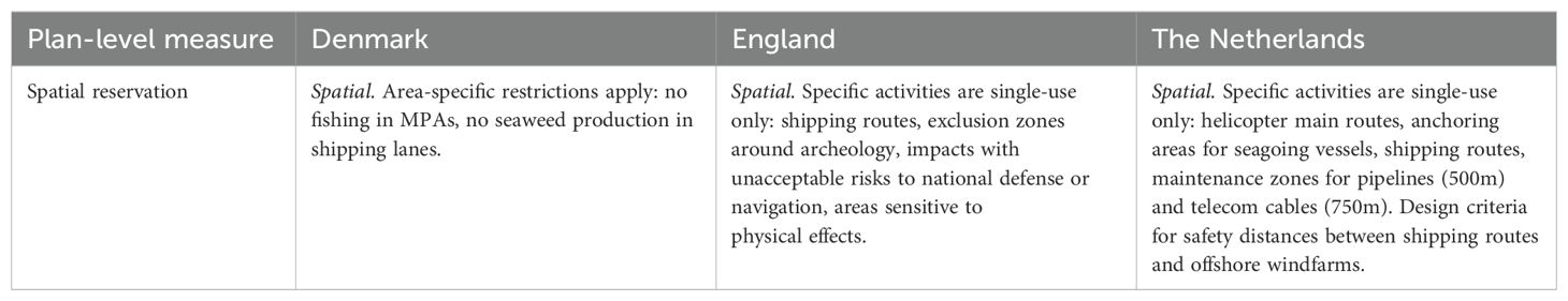
Table 4. Identified project-level conflict resolution measures with a relocation strategy.

Table 5. Identified project-level conflict resolution measures with a minimization strategy.
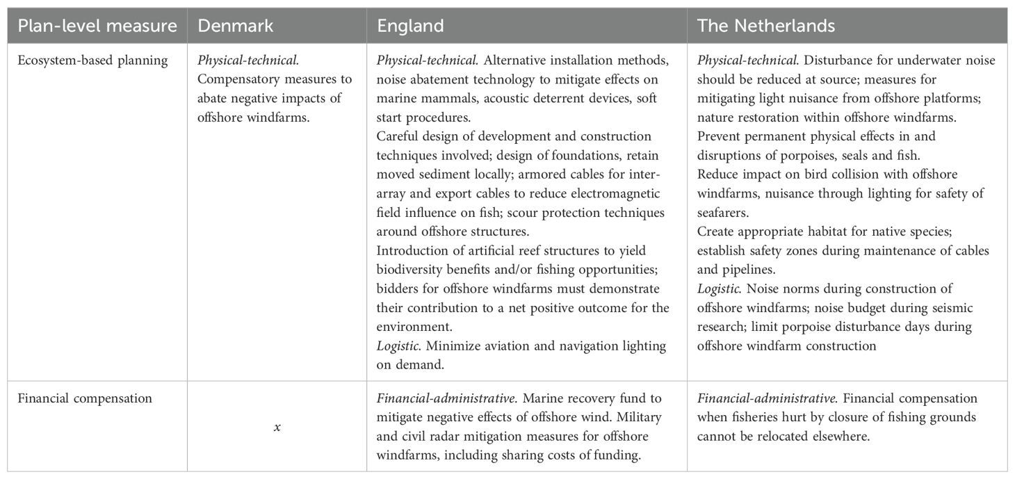
Table 6. Identified project-level conflict resolution strategies with a mitigation strategy.
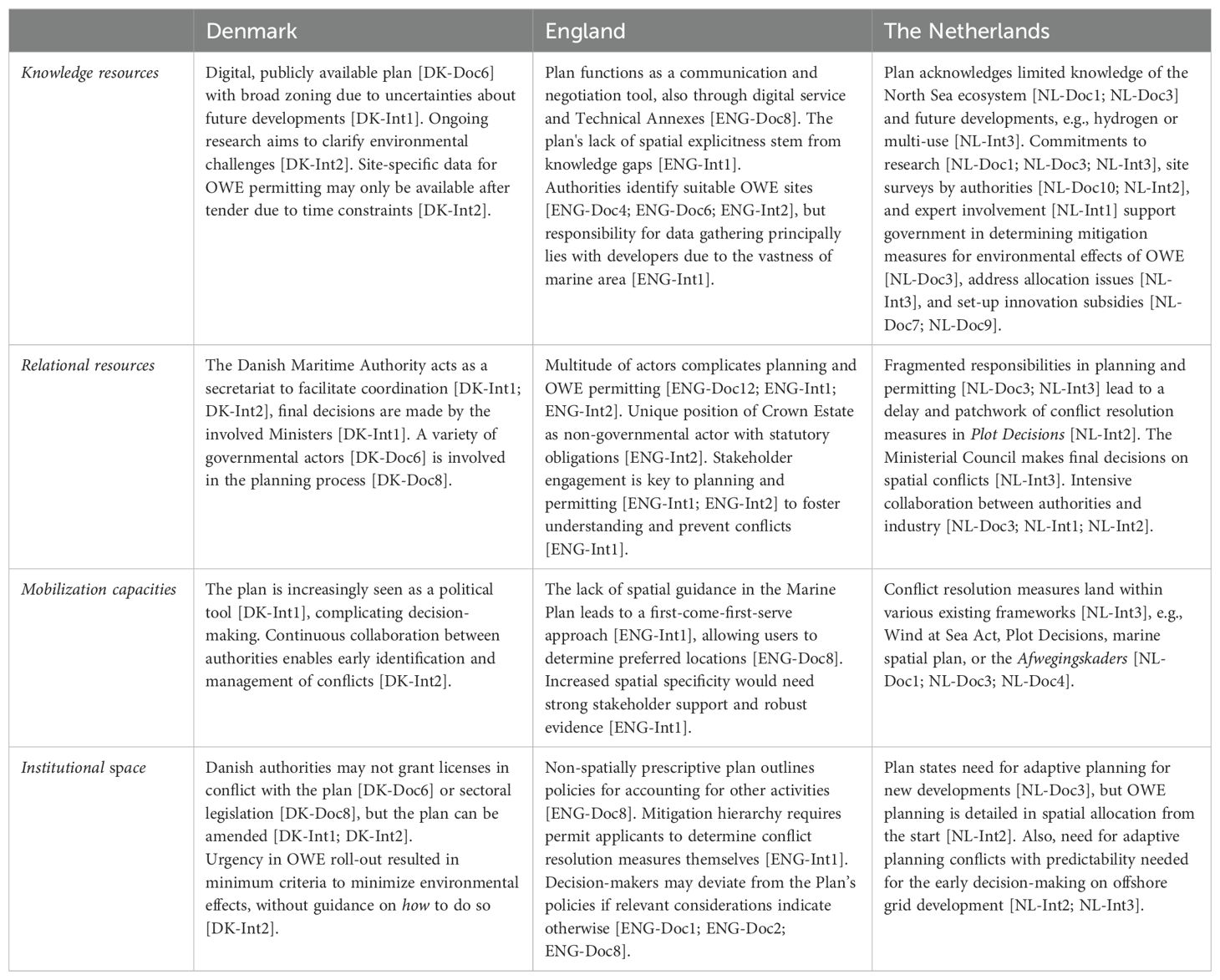
Table 7. Overview of Institutional capacities per case.
Relocating conflicting maritime activities through spatial reservation – i.e. resolving the spatial overlap – is a central tenet behind MSP processes. Although relocation measures are primarily adopted within marine spatial plans, the following paragraphs also shows how these are translated within OWE permitting procedures (see Table 4). Across cases, passive relocation strategies prevail. That means, by reserving space for specific activities, activities other than those designated in specific areas are excluded and prompted to shift elsewhere.
The Danish plan allocates broad development zones for a variety of uses, meaning that the designated activities may only be developed within these delineated zones [DK-Doc6; DK-Int2; see Appendix B, Figure B1 for a map outlining these zones]. As such, the plan provides a first strategic guidance and mentions that area-specific restrictions can emerge from sectoral legislation. To illustrate, the plan itself does not forbid fishing in marine protected areas, but environmental legislation restricts fishing in areas allocated as ‘nature and environmental protection areas’ [DK-Doc6]. Similarly, the Dutch plan also reserves zones for specific activities, albeit in a more detailed manner. For instance, OWE areas are designed to fit specific amounts of GW [NL-Doc3] and, as such, directly displace conflicting activities. Where the broad spatial reservations in the Danish plan do not automatically mean that the designated space will be utilized in the future, the allocated OWE zones in the Dutch plan come with a detailed timeline for development and definitively displace existing activities on the short-term. In contrast, the English plan does not include any spatial allocation or zoning [ENG-Doc8; ENG-Int1]. Rather, it implies a conditional relocation of conflicting uses by protecting areas for possible future developments of, among others, renewable energy, cables, and oil and gas “from other activities that could affect the sites ability to generate energy” [ENG-Doc8, p.32]. Spatial reservation in England does occur on sectoral levels, e.g., marine protected areas are allocated through sectoral plans and policies. Moreover, passive relocation is embedded in sector- or project-specific requirements in permitting procedures (see Appendix B, Table B1). For example, English and Dutch documents pose restrictions stipulating that existing renewable energy developments [ENG-Doc8], shipping routes [ENG-Doc8; NL-Doc3] or maintenance zones for pipelines and telecom cables [NL-Doc4] cannot co-exist with any other uses.
One example of a more proactive relocation strategy involves the potential to appoint fishing areas as compensation for closure of fishing grounds in OWE locations, as indicated by a Dutch policymaker [NL-Int3]. This addresses concerns that fisheries (along with other dynamic activities such as tourism or small shipping) seem more likely to carry the burden of new offshore infrastructure developments. In contrast, Danish and English policymakers regard proactive relocation of fisheries as less urgent, as they still see sufficient physical space within their offshore waters to avoid currently busy areas [DK-Int2; ENG-Int2].
Conflict minimization measures intend to decrease the spatial overlap by adapting one of the spatial claims or activities, rather than completely relocating on the conflicting activities. Multi- or co-use, and ecosystem-based planning measures aim to reduce conflicts respectively by aiming to efficiently allocate multiple uses in one area or adjust the main activity in line with spatially specific ecological parameters. Table 5 presents the identified conflict resolution measures on project-levels.
All three plans emphasize multi- or co-use as a key strategy to optimize the use of maritime space and promote cooperation among marine users, thereby minimizing conflicts over resources and space. Where the Netherlands explicitly refers to multi-use [NL-Doc1; NL-Doc3], both Denmark and England allude to co-use or co-existence of marine activities [DK-Doc6; ENG-Doc2; ENG-Doc8]. To illustrate, in Denmark, co-use is brought into practice by keeping “the plan open when possible” [DK-Int1]. This enables other activities to take place until a specific area will be used for their designated purpose and allows for refinement when new knowledge or stakeholder interests arise. Although the guiding principle of co-use is not explicitly translated in project-level conflict resolution measures, the plan specifies that co-use should be understood in relation to the three-dimensional nature of the sea [DK-Doc6]. That is, activities may take place simultaneously on the surface water, water column and seafloor. Similarly, the English plan broadly states that “proposals that optimize the use of space and incorporate opportunities for co-existence and cooperation with existing activities will be supported” [ENG-Doc8, p.21]. The plan does not designate spatial reservations for specific activities (see Section 4.1), which means that the potential for multi-use depends on who gets there first and whether it can co-exist with a secondary activity [ENG-Int1]. In this context, dynamic activities (e.g., fisheries, tourism, and shipping) are at a disadvantage. Since these typically do not require a place-specific permit, their spatial claims are not protected by existing planning or permitting frameworks. Resultantly, they seem more likely to be displaced by new permitted activities with fixed locations. On a project-level (see Table 5), co-existence of activities is operationalized as a conflict minimization measure through cable burial [ENG-Doc10] or by adapting the layout of offshore windfarms to accommodate the passage of small ships or fishing activity [ENG-Doc15]. In the Netherlands, this plan-level guiding principle is translated into a concrete assessment framework for co-use of OWE including pre-determined potential co-existing uses [NL-Doc3; see Figure 2]. Also, qualitative, non-price criteria in OWE permitting procedures stipulate investments in both floating solar within offshore windfarms [NL-Doc7] as well as ecosystem protection or improvement [NL-Doc4; NL-Doc6; see Table 5].
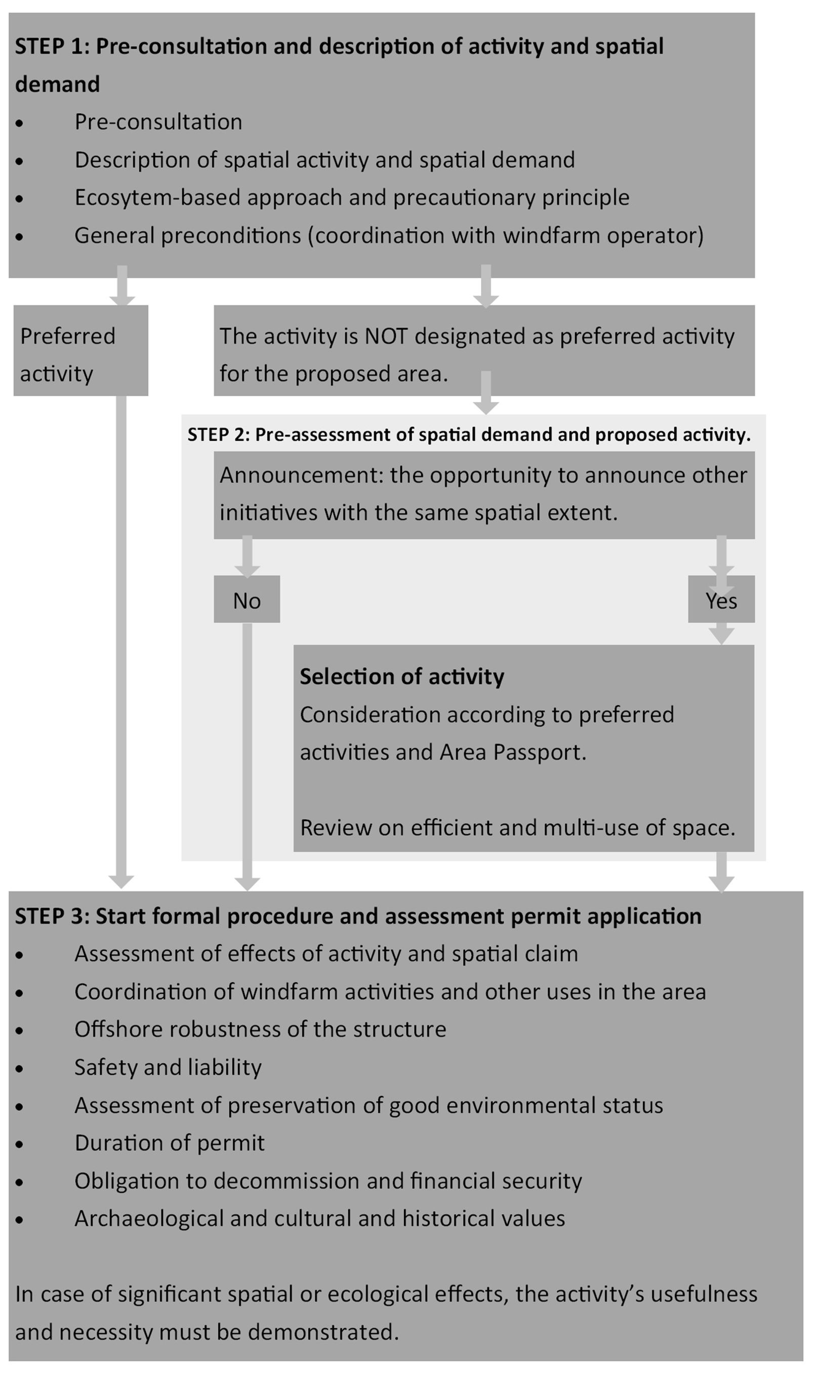
Figure 2. Assessment framework for co-use within offshore wind farms to be used in case of co-use permitting application [NL-Doc3, p.132]. Translated version created by author.
Comparatively most measures identified in permitting documents target the potential conflict with nature, as based on an ecosystem-based planning approach promoted in all three plans [DK-Doc6; ENG-Doc8; NL-Doc3]. These involve both minimization measures (this section) and mitigation measures (presented in Section 4.3). Ecosystem-based minimization measures target the conflict with spatially-specific ecological processes or protected areas – e.g., adjust turbine height to reduce collision risk within bird trek routes [ENG-Doc10] or minimize turbine rotations during bird and bat trek periods [NL-Doc4] – rather than the wider ecological effects which are targeted through mitigation measures. The three cases demonstrate varying applications of this ecosystem-based approach, which is further translated into permitting requirements with different levels of detail and stringency. The Danish plan follows the EU Marine Strategy Framework Directive’s definition3 [DK-Doc6], without stipulating any specific requirements upfront within permitting procedures. Rather, any requirements are based on the results of the Environmental Impact Assessment, which is commissioned by the OWE developers who were granted the permit [DK-Int2]. Although it is clear that the Danish Energy Agency is the responsible authority to check developers’ conformance to the requirements, it is not explicated how the assessment’s results are translated into requirements and how detailed and prescriptive the measures are. Both the English and Dutch plans similarly refer to the EU definition, but respectively further emphasize the precautionary principle [ENG-Doc2] and incorporate a nature-inclusive approach to building new infrastructure [NL-Doc3]. The English and Dutch cases display various measures to minimize the conflict that are set and reviewed by the respective permitting authorities (see Table 5), including temporal restrictions on noisy activities during sensitive periods or specific weather conditions [ENG-Doc10; NL-Doc4] or spatial restrictions to project-layout or maintenance vessel traffic [ENG-Doc10]. Interestingly, both cases further require developers to demonstrate how they “will accelerate progress towards a net positive outcome for environment” [ENG-Doc12, p.45] or state their “contribution [.] to the ecosystem of the Dutch North Sea” [NL-Doc6, p.22]. Where the English leave it to the knowledge and creativity of the market to determine how this should be done, Dutch permitting documents more specifically stipulate that turbines must be built in nature-inclusive manner, enhance underwater nature, and promote biodiversity [NL-Doc4; NL-Doc6]. These differences in approaches are further scrutinized in Section 4.4.
Table 6 outlines the mitigation measures identified within OWE permitting procedures, corresponding to the plan-level measures of ecosystem-based planning and financial compensation.
Beyond conflict minimization, ecosystem-based planning also enables a mitigation or compensation of conflicts’ effects, which may range wider than the designated area for the activity. Identified mitigation measures include, among others, financial compensation for negative environmental effects [ENG-Doc11] or closure of fishing grounds due to OWE [NL-Doc1], alternative installation methods to prevent negative environmental effects of windfarm construction [ENG-Doc10; NL-Doc3], and introducing artificial reef structures to yield biodiversity benefits [ENG-Doc2; ENG-Doc12; NL-Doc4; NL-Doc5]. In contrast to the multitude of measures identified in the Dutch and English documents (see Table 6), Danish documents remain rather abstract by merely stating the need for “appropriate compensatory measures to abate the negative impacts for the [OWE] site” [DK-Doc1, p.12]. As stated in Section 4.2, further area-specific requirements and conflict resolution measures are to be determined based on results from project-specific Environmental Impact Assessments [DK- Int2], though how this occurs, their levels of detail and prescription remain unclear.
A second plan-level mitigation measure enables financial compensation. Within the Dutch North Sea Agreement a so-called ‘transition fund’ is established for investments related to one or multiple of the three transitions facing the North Sea, i.e. nature, energy and food [NL-Doc1]. Although this compensation mechanism can support broader North Sea investments, it also provides decision-makers the opportunity to allocate financial resources to target emerging spatial conflicts more specifically. For example, the fund may provide financial subsidies for a more sustainable fisheries sector or for downsizing the fleet when fishing grounds are closed due to new offshore windfarms [NL-Doc1]. Project-specific financial compensation measures are also identified within English OWE permitting procedures. The British Energy Act establishes a ‘marine recovery fund’ to mitigate negative environmental effects of OWE [ENG-Doc11]. Further, depending on the location, developers may be required to share the costs of effects on military and civil radar technologies [ENG-Doc12]. No project-level measures for financial compensation were identified in the Danish marine spatial plan or OWE permitting procedures.
Denmark, England and the Netherlands each have different institutional capacities shaping the adoption of (various types of) conflict resolution measures (see Table 7 for an overview).
The capacity to mobilize the aforementioned available conflict resolution measures depends on the relational and knowledge resources. Relational resources manifest differently across cases. After plan development, the Danish Maritime Authority functions as a secretariat to facilitate dialogue and decision-making among involved ministries [DK-Doc8; DK-Int1; DK-Int2]. In England, the plan itself intends to function as a communication and negotiation mechanism after a comprehensive stakeholder engagement process aimed at fostering understanding, and frontloading dialogue and conflicts [ENG-Doc8; ENG-Int1]. However, the wide variety of ministries and authorities involved in the plans and permitting procedures is recognized as a complexity in both England and the Netherlands [ENG-Int1; NL-Int2], with a Dutch permitting official stating it makes allocating OWE areas and determining corresponding development requirements almost “a form of diplomacy” [NL-Int2].
Across cases, there is equal recognition of considerable knowledge gaps on the marine environment [DK-Int1; ENG-Int1; NL-Doc3], which differently shaped the respective plans (see Table 7). In Denmark, the open nature of the plan with large area reservations – which remain free to be used for other activities until the designated activity is developed – enables decision-makers to adjust the plan based upon emerging knowledge and become more specific further down the line in permitting and project development [DK-Int1]. In contrast, English policy-makers deal with their lack of robust spatial and environmental evidence base by developing non-spatially prescriptive plans and stipulating general conditions for development [ENG-Int1], under the general premise that developers are to determine preferred locations for activities themselves [ENG-Doc8]. All involved permitting authorities (i.e. the Crown Estate, the Marine Management Organisation, and the Planning Inspectorate) must make decisions in accordance with the plan “unless relevant considerations indicate otherwise” [ENG-Doc8, p.57]. In the Netherlands, the plan’s explicit recognition of a structural lack of knowledge has led to intensified efforts towards research and monitoring programs of the marine environment [NL-Doc3]. This scarcity of knowledge resources identified across cases may not only complicate the identification of where certain spatial conflicts may occur, it simultaneously can undermine the institutional capacities to deploy conflict resolution measures due to a lack of information on their effectiveness.
Abovementioned mobilization capacities refer to those embedded in plan development processes, nevertheless, the knowledge and relational resources also affect permitting procedures. In both Denmark and the Netherlands, OWE permits are handled through a ‘one-stop-shop-approach’ in which the permitting authorities – i.e. respectively the Danish Energy Agency and the Netherlands Enterprise Agency – issue a standardized tender procedure in which developers place bids to develop pre-designated OWE zones. In England, the Crown Estate tailors the approach for each leasing round to broader areas in which OWE may be developed [ENG-Int2]. In all three cases, the permitting authorities responsible for granting right to the seabed conduct location-specific studies to identify environmental conditions, existing spatial claims, and potential other interests. Where the Dutch use this knowledge to specifically prescribe how to resolve project-specific spatial conflicts in permitting requirements – e.g., wind turbines must be paused during periods of bird trek – the Danish and English take a more open approach by stating which conflicts need to be addressed rather than specifying how [DK-Int2; ENG-Int2]. As such, Danish and English decision-makers rely more heavily on the knowledge and creativity of developers to address location-specific conflicts. In the Netherlands, sectoral interests and knowledge are considered in decision-making through an extensive collaboration between authorities and industry actors [NL-Doc3; NL-Int1; NL-Int2]. Regardless, all countries have established strict political targets for OWE and legal obligations on nature protection, which restrict the freedom of developers in determining and implementing novel measures at odds with existing priorities [INT-Int1]. This already shows that market-driven approaches to conflict resolution can offer both benefits as well as pose risks, which is further discussed in Section 5.
In all cases, it was found that governmental responsibilities for plan development and OWE permitting are fragmented between various ministries and authorities (see Table 7). To illustrate, new OWE zones in the Netherlands are appointed in the marine spatial plan by the Ministry of Infrastructure and Water Management. The Plot Decisions – which include area-specific development requirements – are handled by the Ministry of Economic Affairs and Climate who relay part of the work to executive agency Rijkswaterstaat. Thereafter, the Netherlands Enterprise Agency takes care of the permitting procedure. Although these formal responsibilities are clearly demarcated and transparently communicated, the fragmentation of responsibilities does create a certain administrative congestion and potential delays to the formulation of Plot Decisions [NL-Int2]. A similar picture is observed in Denmark and England (see Table 7). This demonstrates that conflict resolution measures land within a wide variety of established legal and policy frameworks. On the one hand, this suggests a degree of institutionalization, supporting decision-makers to strategically leverage and mobilize resources for the adoption of conflict resolution measures. On the other hand, this multitude of sectoral frameworks may crowd the institutional space and requires all authorities and stakeholders to be aware of and be able to navigate them.
Given the aforementioned challenges in mobilizing knowledge and relational resources, it important to consider how this may constrain or open up institutional space and, consequently, how this space offers decision-makers room to maneuver within established norms or procedures. As theorized in Section 2, the findings show that existing legal frameworks can restrict the institutional space and influence to what extent actors are able to mobilize existing knowledge or relational resources. Naturally, all countries are bound by existing sectoral legislation, in which additional requirements for dealing with spatial conflicts are embedded [DK-Doc8; ENG-Int1; NL-Int3]. Most importantly, it is the stringency and specificity of the individual plans that has implications for the way, shape and form in which measures are and can be adopted. The following three paragraphs scrutinize how the nature of the individual plans and permitting procedures shapes the institutional space to mobilize resources and adopt conflict resolution measures.
First, the Danish marine spatial plan designates extensive development zones for, among others, renewable energy and energy islands, but the reserved areas are intentionally larger than necessary to provide spatial flexibility. This need for spatial flexibility is underscored by a Danish policymaker stating: “I do not really understand if anyone can have a plan right now that is lasting more than two years” [DK-Int1]. Although broad zoning embeds considerable spatial flexibility within designated areas, it simultaneously imposes restrictions outside these areas. Specifically, for activities permitted within designated development zones, formal amendments to the plan are required for approval outside these zones [DK-Int1; DK-Int2]. Yet, as the plan is increasingly perceived as a political instrument, one Danish policymaker acknowledges that changes to the plan have become more time- and resource-intensive, particularly because all involved ministries and authorities must agree upon proposed changes [DK-Int1]. This suggests that institutional space is restricted on a plan-level. Contrastingly, the political momentum behind the accelerated rollout of OWE actually expanded institutional space within OWE permitting procedures, offering decision-makers considerable freedom to streamline and standardize OWE permitting [DK-Int2].
Conversely, the English marine plan lacks spatial allocation, but grants decision-makers the discretion to decide how development proposals may or may not support the vision and objectives of the plan, or whether “imperative reasons of overriding public interests” exist [ENG-Doc8]. The broad conditions established in the plan, offer permit applicants considerable institutional space to determine how they will conform to these conditions, but equally grant decision-makers considerable institutional space in assessing permit applications. However, decision-makers lack the strategic guidance needed to effectively utilize this space, rendering it almost an institutional void. Namely, the results show that the English plan provides primarily project-specific, operational guidance for developers, rather than showing how conflicting spatial claims can be or are balanced upfront in a strategic and integrated manner. Moving away from this market-driven approach towards increased strategic spatial guidance seems unlikely in the future. The missing robust evidence base was positioned as the main argument for developing the marine plan without spatial reservations [ENG-Int1]. This suggests that any new governmental spatially specific guidance in the form of conflict resolution measures would require similarly robust evidence (see Table 7).
Interestingly, the Dutch marine spatial plan introduces a broad range of conflict resolution measures for decision-makers to balance interests and make trade-offs, but simultaneously recognizes the need for flexibility to “initiate, accept and realize new and innovative developments” [NL-Doc3]. This raises the question to what extent Dutch decision-makers can realistically make use of the institutional space expressed in the plan. Interviewees suggest that the institutional space for decision-makers is partly undermined by the large share of governmental ministries, departments and authorities involved in planning and permitting [NL-Int1; NL-Int2]. Namely, the complex governmental landscape may make it difficult for both governmental and non-governmental actors to oversee and collaborate with all involved departments and authorities, and for policy-makers specifically, to find consensus in decision-making. Further, the institutional space is hindered by the limited spatial flexibility in the plan. Although the plan is posed as broad in scope [NL-Int2; NL-Int3], OWE areas are appointed for pre-specified amounts of GWs and include limited spatial flexibility. Even if new spatial conflicts are identified during project development phases – e.g. resolved by slightly changing the outer borders of a zone – these zones cannot be deviated from [NL-Int2]. This suggests that institutional space exists mainly for adopting conflict resolution measures within permitting procedures that target physical-technical, financial, or logistic dimensions, and is limitedly shaped at more strategic plan-levels as theorized in Section 2.
Overall, the findings show the institutional space to resolve emerging conflicts in novel ways is limitedly used across cases. This is particularly visible through the following (hypothetical) scenario. When policy-makers were asked how they would handle conflicting permitting applications for offshore activities – i.e. outside of the competitive (tender) procedures for OWE – they widely acknowledged that applications would be assessed on a first-come-first-serve, case-by-case basis [DK-Int2; ENG-Int1; NL-Int1]. No strategic guidance or legal framework was mentioned, that could support them in deviating from this approach and prioritize applications that may be strategically more desirable than the first one. This indicates that institutional space alone (i.e., a lack of strategic guidance or legal framework) is insufficient for decision-makers to act differently and may even function as an institutional void paralyzing decision-making. It further underlines the importance of having capacity to mobilize knowledge and relational resources within established norms and procedures to effectively utilize this institutional space.
A diverse array of conflict resolution measures are adopted in Denmark, England and the Netherlands (see Table 3-6) indicative of the respective institutional capacities (see Table 7). Reflecting upon the results, two noteworthy observations emerge regarding the adopted approaches to conflict resolution: (1) they only limitedly enable a strategic balancing of trade-offs between spatial claims of sectoral activities and (2) they are primarily tailored to minimize or mitigate conflicts within permitting procedures.
First, although MSP literature points out that plans should enable a proactive relocation of displaced activities (see e.g., Bradshaw et al., 2018; Ehler and Douvere, 2009), adopted spatial reservation measures mainly help passively displace original spatial claims in lieu of newly planned activities. The English marine plan avoids spatial allocation entirely and only offers spatial guidance through conditional relocation policies. The Danish plan designates extensive development zones that, due to their size and overlapping designations, defer conflict resolution to future planning and permitting efforts. The Dutch plan offers a detailed allocation of OWE areas for predetermined amounts of GW and alludes to the opportunity to proactively appoint fishing grounds, suggesting comparatively more capacity to resolve spatial conflicts on a strategic level.
The results reveal that these differences in measures for strategic-level conflict resolution are, at least partly, prompted by the (perceived) spatial competition in the respective marine areas. The explicit recognition of spatial congestion by Dutch policy-makers forces them to make detailed decisions on spatial allocation and resolve spatial conflicts upfront, rather than waiting for conflicts to be resolved upon later stages of project development. In contrast, Danish and English policy-makers both perceive sufficient spatial flexibility and ‘empty space’ for dynamic activities to move to different areas in case of spatial conflicts. Earlier research corroborates this observation, showing a concentration of spatial congestion in the Southern North Sea, while Northern areas (which include parts of English and Danish EEZ’s) experience comparatively less pressure (Guşatu et al., 2020). The detailed support for multi- or co-use provided in the Netherlands, in contrast to the limited direction in Denmark and England (see Section 4.2), further underscores that (perceived) spatial congestion can spur the adoption of spatial conflict resolution measures.
The above argument of (perceived) spatial congestion may also explain the adoption of the broad ‘transition fund’ in the Netherlands. The Dutch recognize that not all activities and corresponding spatial demands can be accommodated through a strategic-level spatial allocation. The fund aims to streamline funding for all Dutch North Sea policy (see Spijkerboer, 2021) and enables decision-makers to target spatial conflicts not covered by existing (sectoral) funds. As such, it offers decision-makers institutional space to determine whether and how to compensate those adversely affected by the trade-offs, provided its relation to the nature, energy or food transition.
Across cases, the findings show that the strategic allocation of activities in marine spatial plans is further complicated by the fragmented responsibilities among ministries and authorities as well as a lack of spatial and environmental knowledge (see results in Table 7 and further explanation in Section 4.4; also confirming earlier research by Gill et al., 2018; Spijkerboer, 2021). More importantly, these challenges within relational and knowledge resources are found to constrain the institutional space which decision-makers may deploy for translating measures from the marine spatial plan into permitting procedures. As demonstrated in Section 4, the involvement of numerous authorities in Dutch OWE planning and permitting created a patchwork of measures for OWE-related conflict resolution and is even perceived as a diplomatic effort. This is not only challenging to navigate for both decision-makers and developers, but also offers limited flexibility and adaptability (i.e. institutional space) to make institutional changes. Moreover, considerable knowledge gaps contributed to the English marine plan lacking spatial allocations. Consequently, institutional space to adopt spatially explicit measures only emerge within project development phases. The above empirically substantiates our theorized connections between mobilization capacities and the concept of institutional space (see Section 2). Specifically, the results demonstrate that difficulties in mobilizing knowledge and relational resources can constrain the institutional space of decision-makers to implement new conflict resolution measures.
Second, the findings show a wide variety of minimization or mitigation measures adopted in OWE permitting procedures of England and the Netherlands (see Tables 5 and 6). The prominence of ecosystem-based conflict resolution measures offering project-specific guidance is unsurprising given the shared legal basis protecting the marine ecosystem on an international and European level. This includes, among others, the United Nations (1991), the EU Birds and Habitats Directives (Council Directive 92/43/EEC, 1992; Directive 2009/147/EC, 2009), the Marine Strategy Framework Directive (Directive 2008/56/EC, 2008), and the MSP Directive (Directive 2014/89/EU, 2014).
These legal frameworks led Dutch policy-makers to adopt various measures stipulating how to mitigate or minimize the spatial conflict with specific habitats or species. Conversely, English OWE permitting procedures merely stipulate which conflicts need to be addressed rather than how. Due to the time constraints and political urgency to receive OWE targets, the Danish defer decision-making on which conflicts need to be addressed until the results of the Environmental Impact Assessments become available, even though they are conducted after the first permits are granted. As presented in Section 4.4, both English and Danish decision-makers rely quite heavily on the knowledge and creativity of the sector to find appropriate ways to address conflicts. Although developers are assumed to favor economically efficient measures over more expensive ones, adopting such market-driven approaches can offer opportunities to innovate and implement novel or creative conflict resolution measures unknown to or previously deemed infeasible by decision-makers.
However, having no clear requirements on minimum minimization or mitigation efforts risks that the interests of powerful actors – e.g., the offshore renewable energy sector within MSP processes (Spijkerboer et al., 2020; Kusters et al., 2023) – become subconsciously prioritized. This risk is particularly pronounced in situations of institutional voids, with recent research emphasizing the influential role of informal institutions in the absence of strong formal guidance, such as the aforementioned power relations (Hasan and Bondy, 2024). Similarly, the findings in the Danish and English contexts indicate that in cases of substantial institutional space without strategic guidance on its utilization, market-driven approaches become more prevalent. Subsequently, a question that emerges for decision-makers is to what extent it is appropriate to rely on developers to minimize and mitigate societally relevant spatial conflicts.
Throughout this paper, we repeatedly discuss the importance of institutional space to cope with unforeseen or unprecedented spatial conflicts. In doing so, we do not mean to argue that unlimited institutional space – i.e. an institutional void – is desirable for conflict resolution, especially in the current era of energy transition and large-scale roll-out of OWE. Although Salet (2018) argues that institutional voids may offer considerable institutional space for actors to experiment, low levels of institutionalization also hinder actors’ ability to act strategically and seize opportunities, which eventually may even lead to inertia (Dorado, 2005; Hasan and Bondy, 2024). Along those lines, Spijkerboer (2022) demonstrates that some degree of institutionalization is crucial for creating effective institutional space. Our findings show that challenges in capacity to mobilize resources – i.e. large knowledge gaps and fragmented responsibilities – constrain the extent to which the institutional space can effectively be utilized for, in this case, conflict resolution (Section 4.4). Interestingly, although Section 2 theorized that institutional space could be more easily perceived and pursued on higher levels of abstraction (as based on Spijkerboer, 2022), these challenges in mobilization capacities seem to particularly affect how decision-makers could pursue institutional space on plan-levels. For example, English decision-makers refer to the limited robust spatial evidence base as the main reason for deferring the uptake of spatial conflict resolution measures to project development. Moreover, the fragmentation of governmental responsibilities, recognized in Danish and Dutch cases, created confusion on who should pursue and take ownership of this institutional space on strategic levels, particularly when dealing with various sectoral maritime activities and corresponding authorities. This highlights that pursuing effective institutional space on strategic levels requires institutional guidance, particularly on ownership and shared knowledge bases.
Future research may deepen understanding on this relationship between mobilization capacities and institutional space, particularly regarding conditions contributing to effective institutional space supporting long-term and strategic decision-making versus the conditions contributing to an institutional void or overload. In addition, the role of financial support structures and legal frameworks in mobilizing resources can be further explored (as shown by e.g., Grotenbreg and van Buuren, 2018; Skill et al., 2024), since this is only minimally addressed in the current study.
Overall, this paper demonstrates that spatial conflicts in the marine environment can be and are resolved, minimized and mitigated in a multitude of manners. Most importantly, the findings illustrate that conflict resolution within MSP goes beyond establishing spatial reservations in marine spatial plans (as asserted in early MSP literature, see Calado et al., 2010; Tuda et al., 2014) and also involves measures stimulating multi- or co-use, promoting ecosystem-based planning and enabling financial compensation (see Table 3). Within permitting procedures, a wide variety of spatial, physical-technical, logistic, and financial conflict resolution measures are adopted to minimize or mitigate spatial conflicts on project-specific levels (see Tables 4-6).
The findings show that the adoption of these measures can be, at least partly, explained by the countries’ institutional capacities. Across cases, a lack of spatial and environmental data and fragmented governmental responsibilities constrain the effective institutional space of decision-makers to adopt conflict resolution measures. On the one hand, these difficulties in resource mobilization contributed to a more market-driven approach to conflict resolution within English and Danish permitting procedures, by stating merely which conflicts need to be addressed whilst leaving room for developers to propose how. Conversely, Dutch permitting procedures specifically prescribe how to resolve specific conflicts in line with strategic priorities. Our analysis of institutional capacities does not fully explain these differences, which may also be shaped by national planning cultures and wider governance contexts (e.g., Berisha et al., 2021; Nadin et al., 2024). This offers an interesting avenue for future research, particularly since such differences are likely to affect the increasing sea basin-wide collaboration efforts, such as the Greater North Sea Basin Initiative (2023) or similar endeavors in the Baltic Sea and Atlantic.
The enormous foreseen growth of offshore renewable energy infrastructures towards 2050 coupled with the EU’s ambition to protect 30% of marine habitats by 2030 (European Commission, 2021) necessitates that policy- and decision-makers continuously assess and carefully consider the inevitable trade-offs between spatial claims of maritime activities. Our results illustrate that large knowledge gaps and a fragmentation of governmental responsibilities pose barriers to the institutional space for conflict resolution within MSP practice. Scientists, policymakers and infrastructure developers are already working hard to close existing knowledge gaps through academic and applied research as well as offshore pilots and experiments. We wish to highlight two additional steps to move conflict resolution within MSP practice forward. First, this study demonstrates that conflict resolution does not end with the creation of a marine spatial plan; rather, efforts to resolve spatial conflicts are currently to a large degree deferred to permitting procedures and project development. To enable decision-makers to pursue the institutional space on the strategic level of marine spatial plans, the fragmentation of responsibilities within MSP and permitting should be addressed by clarifying and appointing one governmental authority, department or ministry who takes ownership and set the course for spatial conflict resolution on a strategic level. Centralizing decision-making can smoothen conflict resolution by facilitating discussions on trade-offs between maritime activities and bring together all sectoral considerations and individual measures, allowing a more proactive approach to conflict resolution. Second, given the inherently borderless nature of the sea and the plans for more internationally connected offshore energy systems, we applaud current initiatives for intensified international collaboration (such as the Greater North Sea Basin Initiative and the North Seas Energy Cooperation) and recommend them to proactively include spatial issues in their dialogues. Therein, it is vital importance to share insights into national policies and governance frameworks across borders and sectors, to enable greater international alignment in the forthcoming era of transboundary spatial conflicts.
Regardless of whether authorities have a comprehensive set of conflict resolution measures in place for permitting procedures, marine spatial plans should be regarded as critical instruments for the strategic and integrated management of the inevitable trade-offs between spatial demands of sectoral activities over the long-term.
The datasets presented in this article are not readily available because the interviews contain sensitive and identifiable information on organizational routines and practices. No consent was given by the interviewees to share. A list of analyzed documents is included in the Supplementary Materials. Requests to access the datasets should be directed to ai5lLmgua3VzdGVyc0BydWcubmw=.
The studies involving humans were approved by Research Ethics Committee of the Faculty of Spatial Sciences, University of Groningen. The studies were conducted in accordance with the local legislation and institutional requirements. The participants provided their written informed consent to participate in this study.
JK: Conceptualization, Data curation, Formal Analysis, Investigation, Methodology, Software, Validation, Visualization, Writing – original draft, Writing – review & editing. Fv: Conceptualization, Methodology, Supervision, Writing – original draft, Writing – review & editing. CZ: Conceptualization, Methodology, Supervision, Writing – original draft, Writing – review & editing.
The author(s) declare that financial support was received for the research, authorship, and/or publication of this article. This work was supported by the Dutch Research Council through the NWO research program PhD@Sea (project DOSTA, no: WIND.2019.002). Funding for the open access fee was received from the Faculty of Spatial Sciences Open Access Fund, University of Groningen.
We are grateful to the interviewees who provided their time and expertise on the matter and for the two reviewers and their valuable comments for improving the manuscript.
The authors declare that the research was conducted in the absence of any commercial or financial relationships that could be construed as a potential conflict of interest.
All claims expressed in this article are solely those of the authors and do not necessarily represent those of their affiliated organizations, or those of the publisher, the editors and the reviewers. Any product that may be evaluated in this article, or claim that may be made by its manufacturer, is not guaranteed or endorsed by the publisher.
The Supplementary Material for this article can be found online at: https://www.frontiersin.org/articles/10.3389/fmars.2025.1468734/full#supplementary-material
Alexander K. A. (2020). Conflicts over marine and coastal common resources: causes, governance and prevention. 1st (Milton Park: Routledge).
Berisha E., Cotella G., Janin Rivolin U., Solly A. (2021). Spatial governance and planning systems in the public control of spatial development: a European typology. Eur. Plann. Stud. 29, 181–200. doi: 10.1080/09654313.2020.1726295
Boussarie G., Kopp D., Lavialle G., Mouchet M., Morfin M. (2023). Marine spatial planning to solve increasing conflicts at sea: A framework for prioritizing offshore windfarms and marine protected areas. J. Environ. Manage 339, 117857. doi: 10.1016/J.JENVMAN.2023.117857
Brabant R., Rumes B., Degraer S. (2021). “Occurrence of intense bird migration events at rotor height in Belgian offshore wind farms and curtailment as possible mitigation to reduce collision risk,” in Memoirs on the Marine Environment. Environmental Impacts of Offshore Wind Farms in the Belgian Part of the North Sea. Eds. Degraer S., Brabant R., Rumes B., Vigin L. (Royal Belgian Institute of Natural Sciences, OD Natural Environment, Marine Ecology and Management, Brussels).
Bradshaw C. J. A., Greenhill L., Yates K. L. (2018). “The future of marine spatial planning,” in Offshore Energy and Marine Spatial Planning. Eds. Yates K. L., Bradshaw C. J. A. (Routledge, New York), 284–294. doi: 10.4324/9781315666877
Calado H., Ng K., Johnson D., Sousa L., Phillips M., Alves F. (2010). Marine spatial planning: Lessons learned from the Portuguese debate. Mar. Policy 34, 1341–1349. doi: 10.1016/j.marpol.2010.06.007
Christie N., Smyth K., Barnes R., Elliott M. (2014). Co-location of activities and designations: A means of solving or creating problems in marine spatial planning? Mar. Policy 43, 254–261. doi: 10.1016/j.marpol.2013.06.002
Council Directive 92/43/EEC of 21 May 1992 on the conservation of natural habitats and of wild fauna and flora (1992). European Community. Available online at: https://eur-lex.europa.eu/legal-content/EN/TXT/?uri=celex%3A31992L0043 (Accessed June 5, 2024).
Degraer S., Carey D. A., Coolen J. W. P., Hutchison Z. L., Kerckhof F., Rumes B., et al. (2020). Offshore wind farm artificial reefs affect ecosystem structure and functioning. Oceanography 33, 48–57. doi: 10.2307/26965749
de Koning S., Steins N., van Hoof L. (2021). Balancing sustainability transitions through state-led participatory processes: The case of the dutch north sea agreement. Sustainability 13, 1–16. doi: 10.3390/su13042297
De Magalhães C., Healey P., Madanipour A. (2002). “Assessing institutional capacity for city centre regeneration: newcastle’s grainger town,” in Urban Governance, Institutional Capacity and Social Milieux. Eds. Cars G., Healey P., Madanipour A. (Routledge, London), 45–62.
Directive 2008/56/EC of the European Parliament and of the Council of 17 June 2008 establishing a framework for community action in the field of marine environmental policy (Marine Strategy Framework Directive) (2008). Available online at: https://eur-lex.europa.eu/eli/dir/2008/56/oj (Accessed February 28, 2024).
Directive 2009/147/EC of the European Parliament and of the Council of 30 November 2009 on the conservation of wild birds (2009). European Council. Available online at: https://eur-lex.europa.eu/eli/dir/2009/147/oj (Accessed June 5, 2024).
Directive 2014/89/EU of the European Parliament and of the Council of 23 July 2014 establishing a framework for maritime spatial planning (2014). Available online at: https://eur-lex.europa.eu/legal-content/EN/TXT/?uri=celex%3A32014L0089 (Accessed November 30, 2020).
Domorenok E., Graziano P., Polverari L. (2021). Introduction: policy integration and institutional capacity: theoretical, conceptual and empirical challenges. Policy Soc. 40, 1–18. doi: 10.1080/14494035.2021.1902058
Dorado S. (2005). Institutional entrepreneurship, partaking, and convening. Organ. Stud. 26, 385–414. doi: 10.1177/0170840605050873
Douvere F. (2008). The importance of marine spatial planning in advancing ecosystem-based sea use management. Mar. Policy 32, 762–771. doi: 10.1016/j.marpol.2008.03.021
Ehler C. N., Douvere F. (2009). Marine Spatial Planning: a step-by-step approach toward ecosystem-based management (Paris). Available online at: http://www.unesco-ioc-marinesp.be/uploads/documentenbank/3368f5bcac7792e8da75ed70c9d8dd63.pdf (Accessed December 17, 2020).
ENTSO-E (2024). Offshore Network Development Plans. European offshore network transmission infrastructure needs. Pan-European summary (Brussels). Available online at: https://eepublicdownloads.blob.core.windows.net/public-cdn-container/tyndp-documents/ONDP2024/web_entso-e_ONDP_PanEU_240226.pdf (Accessed June 10, 2024).
European Commission (2021). EU biodiversity strategy for 2030 - Bringing nature back into our lives. Available online at: https://data.europa.eu/doi/10.2779/677548 (Accessed July 21, 2024).
Frederiksen M., Rutte M., De Croo A., Scholz O. (2022). The Esbjerg Declaration on the North Sea as a Green Power Plant of Europe. (Esbjerg).
Gill A. B., Birchenough S. N. R., Jones A. R., Judd A., Jude S., Payo-Payo A., et al. (2018). “Environmental implications of offshore energy,” in Offshore Energy and Marine Spatial Planning. Eds. Yates K. L., Bradshaw C. J. A. (Routledge, London, UK), 132–168.
Grotenbreg S., van Buuren A. (2018). Realizing innovative public waterworks: Aligning administrative capacities in collaborative innovation processes. J. Clean Prod 171, S45–S55. doi: 10.1016/j.jclepro.2016.08.128
Guşatu L. F., Yamu C., Zuidema C., Faaij A. (2020). A spatial analysis of the potentials for offshore wind farm locations in the North Sea Region: challenges and opportunities. ISPRS Int. J. Geoinf 9, 96. doi: 10.3390/ijgi9020096
Guşatu L. F., Zuidema C., Faaij A. (2022). A multi-criteria analysis framework for conflict resolution in the case of offshore wind farm sitting: A study of England and the Netherlands offshore space. Front. Mar. Sci. 9. doi: 10.3389/FMARS.2022.959375
Hasan M. N., Bondy K. (2024). Reframing informal institutional voids as the attempted remaking of contested social spaces: evidence from England. J. Manage. Inq, 1–19. doi: 10.1177/10564926241242045
Hatenboer C., van den Berg C., Holzhacker R. (2023). The Dutch fisheries sector and the North Sea Accord: Unpacking stakeholder participation in multi-levelled marine governance. Mar. Policy 147, 105364. doi: 10.1016/j.marpol.2022.105364
Healey P. (1998). Building institutional capacity through collaborative approaches to urban planning. Environ. Plann. A: Economy Space 30, 1531–1546. doi: 10.1068/a301531
Healey P. (2004). The treatment of space and place in the new strategic spatial planning in Europe. Int. J. Urban Reg. Res. 28, 45–67. doi: 10.1111/j.0309-1317.2004.00502.x
ICES (2017). Report of the workshop on conflicts and coexistence in marine spatial planning (WKCCMSP). ICES CM 2015/SSGEPI:22, Geesthacht, Germany. (Copenhagen:ICES). 8–12. doi: 10.17895/ices.pub.8535
ICES (2020). Working Group for Marine Planning and Coastal Zone Management (WGMPCZM; outputs from 2019 meeting). ICES Sci. Rep. 2, 65. doi: 10.17895/ices.pub.5964
Isaksson K., Hagbert P. (2020). Institutional capacity to integrate ‘radical’ perspectives on sustainability in small municipalities: experiences from Sweden. Environ. Innov. Soc. Transit 36, 83–93. doi: 10.1016/j.eist.2020.05.002
Jay S., Flannery W., Vince J., Wen-Hong L., Xue J. G., Matczak M., et al. (2013). International progress in marine spatial planning. Ocean Yearbook Online 27, 171–212. doi: 10.1163/22116001-90000159
Kusters J. E. H., van Kann F. M. G., Zuidema C. (2023). Exploring agenda-setting of offshore energy innovations: Niche-regime interactions in Dutch Marine Spatial Planning processes. Environ. Innov. Soc. Transit 47, 100705. doi: 10.1016/J.EIST.2023.100705
Kyriazi Z. (2018). From identification of compatibilities and conflicts to reaching marine spatial allocation agreements. Review of actions required and relevant tools and processes. Ocean Coast. Manag 166, 103–112. doi: 10.1016/J.OCECOAMAN.2018.03.018
Nadin V., Cotella G., Schmitt P. (Eds.) (2024). Spatial Planning Systems in Europe (Cheltenham: Edward Elgar Publishing). doi: 10.4337/9781839106255
North Seas Energy Cooperation (2023). North Seas Energy Cooperation Action Agenda 2023-2024 on implementing the offshore ambitions in the North Seas. Available online at: https://energy.ec.europa.eu/system/files/2023-11/Actie%20agenda%20DEF.pdf (Accessed June 10, 2024).
Oteman M., Wiering M., Helderman J.-K. (2014). The institutional space of community initiatives for renewable energy: a comparative case study of the Netherlands, Germany and Denmark. Energy Sustain Soc. 4, 11. doi: 10.1186/2192-0567-4-11
Pınarbaşı K., Galparsoro I., Borja Á., Stelzenmüller V., Ehler C. N., Gimpel A. (2017). Decision support tools in marine spatial planning: Present applications, gaps and future perspectives. Mar. Policy 83, 83–91. doi: 10.1016/j.marpol.2017.05.031
Ramírez-Monsalve P., van Tatenhove J. (2020). Mechanisms of power in maritime spatial planning processes in Denmark. Ocean Coast. Manag 198, 1–11. doi: 10.1016/j.ocecoaman.2020.105367
Rodríguez-Pose A. (2020). Institutions and the fortunes of territories. Regional Sci. Policy Pract. 12, 371–386. doi: 10.1111/rsp3.12277
Schaefer N., Barale V. (2011). Maritime spatial planning: opportunities & challenges in the framework of the EU integrated maritime policy. J. Coast. Conserv. 15, 237–245. doi: 10.1007/s11852-011-0154-3
Skill K., Farhangi M., Trygg K. (2024). Size matters: action space for sustainability transition among planners in Swedish municipalities. Urban Res. Pract. 17, 329–346. doi: 10.1080/17535069.2023.2209554
Spijkerboer R. C. (2021). The institutional dimension of integration in marine spatial planning: the case of the Dutch North Sea dialogues and agreement. Front. Mar. Sci. 8. doi: 10.3389/fmars.2021.712982
Spijkerboer R. C. (2022). Institutional harmonization for energy transition (Groningen: University of Groningen). doi: 10.33612/diss.211259536
Spijkerboer R. C., Zuidema C., Busscher T., Arts J. (2020). The performance of marine spatial planning in coordinating offshore wind energy with other sea-uses: The case of the Dutch North Sea. Mar. Policy 115, 1–10. doi: 10.1016/j.marpol.2020.103860
Stepanova O., Bruckmeier K. (2013). The relevance of environmental conflict research for coastal management. A review of concepts, approaches and methods with a focus on Europe. Ocean Coast. Manag 75, 20–32. doi: 10.1016/j.ocecoaman.2013.01.007
Trygg K., Wenander H. (2022). Strategic spatial planning for sustainable development – Swedish planners’ institutional capacity. Eur. Plann. Stud. 30, 1985–2001. doi: 10.1080/09654313.2021.2001792
Tuda A. O., Stevens T. F., Rodwell L. D. (2014). Resolving coastal conflicts using marine spatial planning. J. Environ. Manage 133, 59–68. doi: 10.1016/J.JENVMAN.2013.10.029
United Nations (1991). Espoo Convention on Environmental Impact Assessment in a Transboundary Context. Available online at: https://treaties.un.org/pages/ViewDetails.aspx?src=IND&mtdsg_no=XXVII-4&chapter=27&clang=_en (Accessed April 6, 2023).
Van Den Burg S. W. K., Chouchane H., Kraan M., Selnes T., Roebeling P., Bogers M., et al. (2022). Assessment of the relevance and effect of the Maritime Spatial Planning Directive in the context of the European Green Deal. Final Rep. Brussels, 1–58. doi: 10.2926/911941
Wiegner J. F., Andreasson L. M., Kusters J. E. H., Nienhuis R. M. (2024). Interdisciplinary perspectives on offshore energy system integration in the North Sea: A systematic literature review. Renewable Sustain. Energy Rev. 189, 113970. doi: 10.1016/j.rser.2023.113970
WindEurope (2023). EU leaders meet in Ostend to agree rapid build-out of offshore wind in the North Seas (WindEurope). Available online at: https://windeurope.org/newsroom/press-releases/eu-leaders-meet-in-ostend-to-agree-rapid-build-out-of-offshore-wind-in-the-north-seas/ (Accessed July 31, 2023).
Yates K. L., Schoeman D. S., Klein C. J. (2015). Ocean zoning for conservation, fisheries and marine renewable energy: Assessing trade-offs and co-location opportunities. J. Environ. Manage 152, 201–209. doi: 10.1016/j.jenvman.2015.01.045
Keywords: marine spatial planning, spatial conflict, North Sea, conflict resolution, permitting procedures, institutional capacities
Citation: Kusters JEH, van Kann FMG and Zuidema C (2025) Spatial conflict resolution in marine spatial plans and permitting procedures for offshore wind energy: an analysis of measures adopted in Denmark, England and the Netherlands. Front. Mar. Sci. 12:1468734. doi: 10.3389/fmars.2025.1468734
Received: 22 July 2024; Accepted: 21 January 2025;
Published: 05 February 2025.
Edited by:
Michael Gilek, Södertörn University, SwedenReviewed by:
Nitin Agarwala, Centre for Joint Warfare Studies, IndiaCopyright © 2025 Kusters, van Kann and Zuidema. This is an open-access article distributed under the terms of the Creative Commons Attribution License (CC BY). The use, distribution or reproduction in other forums is permitted, provided the original author(s) and the copyright owner(s) are credited and that the original publication in this journal is cited, in accordance with accepted academic practice. No use, distribution or reproduction is permitted which does not comply with these terms.
*Correspondence: Juul E. H. Kusters, ai5lLmgua3VzdGVyc0BydWcubmw=
Disclaimer: All claims expressed in this article are solely those of the authors and do not necessarily represent those of their affiliated organizations, or those of the publisher, the editors and the reviewers. Any product that may be evaluated in this article or claim that may be made by its manufacturer is not guaranteed or endorsed by the publisher.
Research integrity at Frontiers
Learn more about the work of our research integrity team to safeguard the quality of each article we publish.