 Letian Ma
 Jiabiao Li1,2
 Xuwen Feng
 Tianyao Hao
 Fangzhou Nan
- 1Key Laboratory of Submarine Geosciences, Ministry of Natural Resources, Hangzhou, China
- 2Second Institute of Oceanography, Ministry of Natural Resources, Hangzhou, China
- 3Institute of Geology and Geophysics, Chinese Academy of Sciences, Beijing, China
Rising demand for marine resources has led to a great interest in seabed exploration and mining, while deep-sea environments are faced with cumulative effects of many human activities. Currently, conducting an environmental impact assessment for deep-sea exploration and mining is challenging due to the dynamic nature and a lack of high-quality data. The International Seabed Authority (ISA), which charges with regulating human activities on the seabed beyond the continental shelf, requires contractors to establish both geological and environmental baselines. Also, the ISA provides a general environmental guideline for exploring various seabed resources. However, standardization of its implementation would need to be addressed with specified technical international standards. The marine technology subcommittee of International Standardization Organization (ISO) contributes to the study of standards on deep-sea geological, geophysical and biological surveys, also on marine environmental protection. In this review, we explore two broad aspects of ISO standards: (1) the development of marine geological and geophysical exploration standard, which may help to establish geological map in the seabed area. (2) the current state of development of a series of Marine Environmental Impact Assessment (MEIA) standards, which could standardize the environmental surveys and monitoring activities in the seabed area. We also consider the standardization gap between MEIA and seabed mining, and propose future focus on coordination relationship between marine exploration and environmental protection.
1 Introduction
Marine exploration is an important approach for investigating earth system evolution, predicting seabed resource formation, and understanding natural disaster mechanisms. With the continuous increase in marine exploration, deep-sea environments are impacted by the cumulative effects of many human activities, such as large marine litter (Bergmann and Klages, 2012) and microplastics (Courtene-Jones et al., 2019) on the deep seafloor which may affect benthic ecosystems, offshore industries (i.e., bottom trawling and oil/gas) which may disturb deep-sea habitats (Aguzzi et al., in press), and the ecological impact (i.e. lighting, noise and routine discharges) of mining in the deep sea (Kaikkonen et al., 2018). United Nations (UN) agencies have proposed criteria for managing marine environmental conditions, e.g., criteria including Ecologically and Biologically Significant Areas (EBSAs) by the Convention for Biological Diversity (Secretariat of the CBD, 2021) and Particularly Sensitive Sea Areas (PSSAs) by the International Maritime Organization (IMO, 2006). As more attention has been paid to the potential environmental impacts of deep-sea exploration, there is a need to establish international standards that provide technical support to the UN policies and to conduct a practical marine environment impact assessment (MEIA) for marine investigation and seabed mining.
The ISA is established under the United Nations Convention on the Law of the Sea (UNCLOS) to control mineral-resources-related activities in seabed area beyond national jurisdiction (the Area) (Kaikkonen et al., 2018; http://www.isa.org.jm/about-isa/). The ISA have issued recommendations for the guidance of contractors for the assessment of environmental impacts of mineral exploration in the Area (ISA, 2013; Miller et al., 2018; Thompson et al., 2018; ISA, 2020; Christiansen et al., 2022; ISA, 2022). The recommendations briefly describe the procedures to be followed in the acquisition of baseline data, and the monitoring to be performed during and after the exploration activities (ISA, 2022), which provide a basic framework for MEIA. However, specific technical details have rarely been included in the ISA recommendations, i.e., the design of survey lines and sampling strategies for biological fauna. Thus, developing detailed technical international standards for conducting marine exploration regarding the assessment of the environmental impacts is imperative, and it is a technical complementary to ISA recommendations. These standards shall include two logically related fields: (1) standards relating to geological and geophysical explorations, which enabled the high-resolution mapping of seabed structures and new resources; (2) standards relating to biological and environmental investigations to assess the ecological impacts of exploration activities and deep-sea mining.
Based on ten years of ISO work in the field of marine technology, herein, we review various ISO standards for marine exploration and environmental impact assessment, and provide suggestions for future development. We consider two broad aspects related to international standards: (1) the development of ISO standards on marine geological and geophysical surveys, such as the published ISO 3482. It standardize a seismic survey, Ocean Bottom Seismometers (OBS), in order to reveal crust structure beneath the ocean and magma chamber information, which may help analyzing the environmental changes caused by submarine earthquakes or volcanic eruptions, and (2) the publication of a series of ISO standards on MEIA close to marine biological and environmental surveys, which may help establishing the environmental baselines for deep-sea mining (Figure 1).
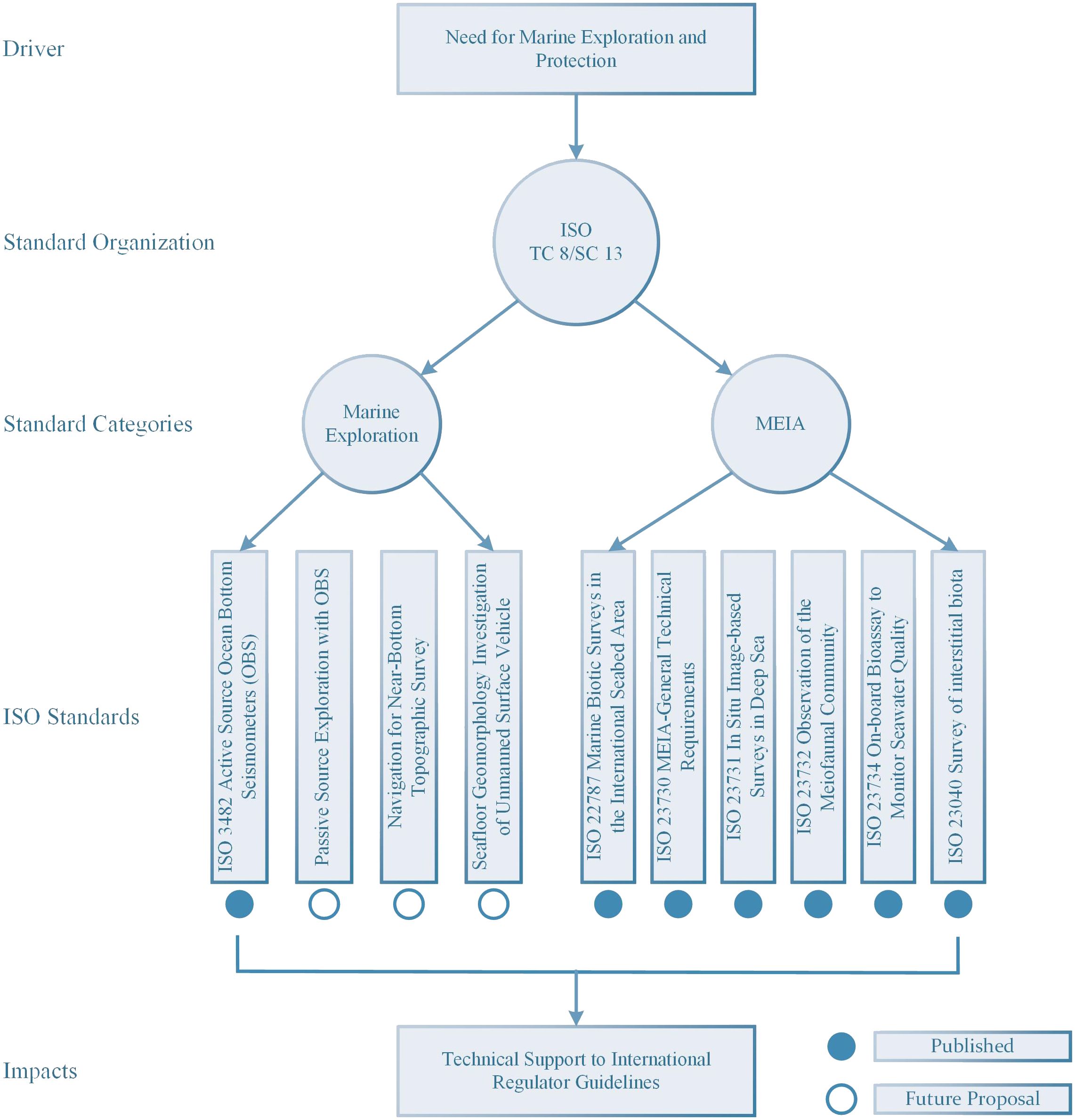
Figure 1 The framework of marine exploration and MEIA standardization in the ISO.
2 Marine exploration and MEIA standardization work in the ISO
ISO is an independent, nongovernmental international organization with a membership of 169 national standards bodies. The ISO standards are established by 825 technical committees and subcommittees [https://www.iso.org/about-us.html]. Marine Technology Subcommittee SC 13 of the ISO Technical Committee TC 8 (ISO/TC 8/SC 13) provides a reliable international platform for negotiating and specifying requirements for sustainable marine exploration activities. There are international standards for geological and geophysical explorations before the establishment of ISO/TC 8/SC 13, e.g., the American Society of Testing Materials (ASTM), including the standard guide for using the seismic refraction method for subsurface investigation (ASTM D5777–18) (ASTM, 2019) and the standard guide for using the seismic-reflection method for shallow subsurface investigation (ASTM D7128–18) (ASTM, 2018), and the International Organization for Standardization (ISO) standards, including ISO 16063–42 (ISO, 2014). However, they are limited to the common approaches for seismic measurements on land and cannot be applied to deep-sea adaptations of geophysical measurements. In addition, they do not address the details of field procedures or data services. Since 2014, ISO/TC 8/SC 13 has operated six working groups (WGs) and developed 15 standards. WG 4 is responsible for the MEIA, and WG 6 oversees seabed exploration. The other WGs focus on marine observation, investigation instruments, resource utilization, and climate change.
ISO standards related to marine exploration and its environmental impact assessment are presented in (Table 1):
Table 1 ISO standards related to marine exploration and its environmental impact assessment.
ISO 3482 focuses on marine geological and geophysical exploration. It specifies the technical requirements for active source exploration using OBSs. Furthermore, it is related to marine geophysical investigation and can be used in offshore resources surveys, geological disaster surveillance, and regional deep earth exploration (ISO, 2022a).
Several ISO standards have been published to assess the degree of impact of deep-sea activities on the marine environment. ISO/TC 8/SC 13/WG 4, a working group of MEIA, has published six standards: ISO 23730, 23731, 23732, 23734, 23040, and 22787.
ISO 23730 and 22787 provide general technical requirements for MEIA (ISO, 2022b) and general principles for biotic surveys in the international seabed areas (ISO, 2023). ISO 23040 and 23732 provide detailed specifications for marine biotic surveys of different biomes (ISO, 2021a, b). ISO 23731 specifies the performance requirements for imaging equipment for deep-sea environments (ISO, 2021c), and ISO 23734 specifies a bioassay method to provide preliminary data for the quality assessment of shipboard seawater at deep-sea mining sites (ISO, 2021d).
A preliminary framework of international standards for marine exploration and the environmental impact assessment has been established over the past decade. Considering that standards for marine geological and geophysical exploration activities have not been systematized, herein, we discuss the opportunities for developing potential standards while highlighting the published ISO 3482. For MEIA, most existing standards are related to marine biotic investigation and seabed mining. Herein, we review several MEIA standards, focusing on the possibility of providing technical support to other international organizations in policy-making.
3 Marine geological and geophysical exploration perspectives on ISO standards
3.1 ISO 3482: specification standard for marine geological and geophysical exploration—importance, technology maturity, and market validation of OBS
The earth’s internal structure is mainly understood from earthquake observation data. The data can be obtained by laying seismic stations on the surface. Seismic observation stations are primarily distributed on land and islands; therefore, detailed seismic investigation of the earth’s deep structure beneath the ocean, which covers approximately 71% of the earth’s surface, is a challenge, particularly because of the obstacles caused by the water layer spanning hundreds to thousands of meters. OBS is a seismic observation station that places a detector directly on the ocean floor and can be used to detect earthquakes from natural and artificial sources. Compared with the traditional ship-borne towed multichannel seismic system, OBS detection has the following advantages in data acquisition: (1) it is directly in contact with the seabed and can receive primary and shear waves from the earth’s interior (Jacobson et al., 1991); (2) in addition to reflection seismic surveys at small offsets, OBS can be used for wide-angle reflection/refraction surveys and natural seismic observations at large offsets to explore the deep crust–mantle structure (WHOI, 2000, 2002); (3) it has low environmental noise, high detection accuracy, and high signal resolution (Hao et al., 2022).
The first independent OBS prototypes were released and tested in the 1930s (Ewing and Vine, 1938; Beer et al., 2015). Since the 1960s, OBS has been employed in marine observations. For example, the United States deployed OBSs manufactured by Texas Instruments Company for observations in the Kuril Islands and Kamchatka (WHOI, 2000, 2002; Liu et al., 2012) and promoted the Vela Uniform Project to normalize passive and active observations of OBSs (Sutton et al., 1965). Because of the limitations of industrial technologies, such as magnetic tape analog recording storage media technology and batteries in the 1970s and early 1980s, OBSs for seabed observation were mostly short-time equipment, staying on the seabed for no more than 3 months, and were only used in artificial seismic tests (Trnkoczy et al., 2012). Since the 1990s, with the rapid development of digital storage technology, the promotion of large international marine geoscience projects, such as the InterRidge project for midocean ridge surveys and the MARGINS project for subduction zone surveys, and the need for offshore oil and gas industry, the research and industrial communities have considerably promoted the development of modern digital OBSs. The United States, Europe, Japan, and China developed broadband digital OBS manufacturing technology and conducted sea tests in the late 1990s and early 2000s (Hao et al., 2022). Over the past two decades, the application of OBSs has been expanded to active and passive surveys as well as the detection of seismic activities, such as seabed microearthquakes. OBSs are categorized into two types based on their recording duration: short-period OBS (SPOBS) and broadband OBS (BBOBS). SPOBS is usually employed in active-source artificial seismic exploration and short-time microseismic detection experiments, while BBOBS provides seismic observation capability similar to that of terrestrial seismographs, with a high dynamic range and stable internal clock. Considering OBSs from international oceanographic research institutions as examples, the parameters of SPOBS and BBOBS between different manufacturers are compared (see Supplementary Material).
Currently, the OBS method is one of the most effective geophysical methods for studying the deep structure. It is widely used to study subduction zones (Zhao et al., 2018; Akuhara et al., 2023), continental margins (Lester et al., 2014; Brotzer et al., 2022), and midocean ridges (Schlinndwein et al., 2015; Ding et al., 2022), and to explore oil and gas (Mienert et al., 2005; Mark and Mona, 2008), gas hydrates (Westbrock et al., 2008; Dash and Spence, 2011; Satyavani et al., 2016), marine engineering constructions and marine carbon geological storage (Leung et al., 2014).
3.2 Purpose and justification of ISO 3482
OBS has gained much interest in both industrial and academic communities. However, the performance of OBSs produced by different manufacturers varies. Their technical requirements, such as instrument assembly and calibration, field design, OBS delivery, seismic sources, OBS recovery, and data processing, also differ. On the one hand, the loss rate of an OBS may increase during fieldwork because of the nonstandardized operation. There may also be no or low-quality data after OBS recovery. On the other hand, standardized OBS data processing criteria help to efficiently obtain reliable seismic data and geological results. Therefore, it is necessary to standardize OBS technical requirements and basic procedures to promote international cooperation in seabed geological and geophysical exploration.
3.3 Scope and stakeholders of ISO 3482
ISO 3482: 2022 ‘Ships and marine technology—Technical guidelines for active source exploration with OBS’ establishes the technical guidelines covering procedures for reference/positioning system, instrument calibration, field design, OBS delivery, seismic sources, OBS recovery, exploration process, data acquisition, and data processing (ISO, 2022a). It benefits stakeholders from various communities, such as large industries and small- and medium-sized enterprises that conduct deep-sea seismic surveys, government, academic and research bodies, and nongovernmental organizations. For example, it provides technical assistance for ISA in establishing geological map in the seabed area to regulate future seabed exploration.
4 MEIA perspectives on ISO standards
4.1 Standards related to MEIA: an overview and a comparison with ISA recommendation
The following general principle standards related to MEIA have been published (Table 1):
ISO 23730: This standard defines a concept and general technical requirements for MEIA operation, including cost-effective deep-sea survey and monitoring, habitat mapping based on baseline data, estimation of impacts from seabed mining, monitoring of measures for mitigation, and postmining monitoring (ISO, 2022b). It does not provide legal or administrative requirements or protocols on MEIA, which would be under the scope of ISA.
ISO 22787: This standard is applicable to marine biotic surveys in international seabed areas. It provides general technical recommendations for components of marine biotic surveys in international seabed areas, including station and survey line design, sampling strategies, survey items, equipment for survey and analysis, and sample preservation (ISO, 2023). This standard involves the design of survey lines and sampling strategies, and provide a detailed description of biological communities, which are given as a preliminary introduction in the ISA recommendation (ISA, 2020).
The following specification standards related to marine biotic surveys for different biomes have been published (Table 1):
ISO 23040: This standard is applicable to marine surveys in diverse benthic habitats on any seabed, such as benthic sediments of coastal zones, shallow seas, or deep-sea waters. It specifies requirements and recommendations for conducting marine surveys of interstitial biota in marine sediments (ISO, 2021a).
ISO 23732: This standard is applicable to marine environment impact assessments and other occasions where long-term image-based data are required. It specifies a general protocol for the observation of the meiofaunal community in deep sea and provides a standardized method applicable in baseline data acquisition and monitoring during and after mining (testing) accompanying resource development, making it easier to compare data beyond differences in workers and waters. The ISA recommendation mandates to obtain data on population density, biomass and species composition for meiofauna, and ISO 23732 provides a new method aligned to the recommendation (ISA, 2020; ISO, 2021b).
The published specification standards related to equipment performance requirements or methods are as follows (Table 1):
ISO 23731: This standard specifies minimum requirements and provides recommendations for gathering image-based data at the seafloor where epifauna and benthopelagic fauna with a minimum dimension of 1 cm are used as a proxy for the status of the biological community. The ISA recommendation requires for long-term data sets of different environments within the proposed mining field to monitor any environmental impacts due to extraction and processing of minerals, and ISO 23731 standardized a long-term in situ image-based survey in the seabed area to get such data sets (ISA, 2020; ISO, 2021c).
ISO 23734: This standard is applicable onboard to generate basic data for seawater quality management at deep-sea mining sites where time and space are extremely limited. The ISA recommendation states that MEIA should address various water quality management fields, which directly or indirectly affected by mining and mineral transport process, and ISO 23734 specifies a bioassay method for determining the presence of unknown toxic contaminants in the test seawater (ISA, 2020; ISO, 2021d).
4.2 Gap addressed in standardization for MEIA and seabed mining
As a prerequisite for evaluating the effects of seabed mining activities, the environmental baseline is essential for monitoring impacts and measuring the possibility of recovery or rehabilitation (Xu et al., 2023). The ISA requires contractors to establish environmental baseline for their respective contract areas to assess environmental impacts of mining (Christiansen et al., 2022). However, it is challenging to establish robust and comparable baseline due to uncertainties in environmental conditions and the limited spatial–temporal data (Thompson et al., 2018). Thus, the gaps on what a robust environmental baseline entails and how to evaluate the quality of baselines are still existing.
The development of consensus-based international standards is a possible approach to addressing this gap. At the international regulator level, the Legal and Technical Commission of ISA considers standards a priority to assess the deep-sea environment (Xu et al., 2023). ‘Recommendations for the guidance of contractors for the assessment of the possible environmental impacts arising from exploration for marine minerals in the Area’ was published by ISA (ISA, 2013, ISA, 2020, 2022) as a general environmental guideline for exploring various seabed resources. At the nongovernmental organization level, ISO 14001 ‘Environmental management systems—Requirements with guidance for use’ provides a framework to change environmental conditions while balancing socioeconomic needs (ISO, 2015) and specifies a common language and guidelines for environmental management. However, these guidelines need to be complemented by specific technical standards to facilitate their implementation.
Therefore, the series of ISO MEIA standards provide technical specifications for deep-sea mining to standardize the biota survey and monitoring activities under the general guidelines of ISA and to maintain the equipment performance and data quality on assessment (ISO, 2022b). The standards cover the following areas: cost-effective operation (ISO, 2023), habitat mapping (ISO, 2021b), estimation of impacts and resilience (ISO, 2021d), and monitoring equipment performance (ISO, 2021c).
5 Discussion and future development
Improved methods of geological and geophysical investigation have enabled the imaging of structure beneath the ocean and the mapping of seabed resources. Progress on biological and environmental investigation have made risk assessment and environmental management for seabed mining possible. The international regulator, ISA, publishes general environmental recommendations to regulate mining activities. While the above improvements have been made, there continues to be a lack of specified technical standards to regulate marine exploration surveys, assess the environmental impacts, and support the ISA recommendations.
In this paper, we reviewed the marine exploration and MEIA standardization by ISO/TC 8/SC 13, which would technically support the governance of the deep-sea environment. ISO standards relating to geological and geophysical surveys provides the technical requirements and basic procedures to promote the healthy development of seabed seismic exploration. ISO standards relating to MEIA have preliminary addressed a standardization gap between environmental impact assessment and seabed mining. We recommend the following criteria for future standardizations:
1. The content of marine geological and geophysical standards in ISO, such as technical requirements of passive source exploration with OBS, navigation and positioning for near-bottom topographic survey, and seafloor geomorphology investigation of unmanned surface vehicle, should be expanded (Figure 1). The future standard proposals will focus on recognizing deep and shallow seabed structures with different investigation methods and predicting resources formation.
2. Legislated organizations (ISA or other regulatory bodies) should be supported by technical standards to minimize the environmental impact of seabed exploration activities. Such support may include promoting a liaison relationship or organizations with observer status between ISO and ISA.
Author contributions
LM: Writing – original draft, Conceptualization. JL: Writing – review & editing, Conceptualization. XF: Writing – review & editing, Conceptualization. TH: Writing – review & editing, Resources, Conceptualization. FN: Writing – review & editing, Resources, Conceptualization.
Funding
The author(s) declare financial support was received for the research, authorship, and/or publication of this article. This work is supported by National Key Research and Development Program of China (2023YFF0803401), National Natural Science Foundation of China (Grant 42025601) , and National Key Research and Development Program of China (2021YFF0601700).
Acknowledgments
The authors would like to thank Shangguo Chen for improving Figure 1. The authors would like to thank the reviewer and editor for their insightful comments which substantially improved the manuscript.
Conflict of interest
The authors declare that the research was conducted in the absence of any commercial or financial relationships that could be construed as a potential conflict of interest.
Publisher’s note
All claims expressed in this article are solely those of the authors and do not necessarily represent those of their affiliated organizations, or those of the publisher, the editors and the reviewers. Any product that may be evaluated in this article, or claim that may be made by its manufacturer, is not guaranteed or endorsed by the publisher.
Supplementary material
The Supplementary Material for this article can be found online at: https://www.frontiersin.org/articles/10.3389/fmars.2024.1389906/full#supplementary-material
References
Aguzzi J., Thomsen L., Flögel S., Robinson N. J., Picardi G., Chatzievangelou D., et al. New technologies for monitoring and upscaling marine ecosystem restoration in deep-sea environments. Engineering. doi: 10.1016/j.eng.2023.10.012
Akuhara T., Yamashita Y., Ohyanagi S., Sawaki Y., Yamada T., Shinohara M. (2023). Shallow low-velocity layer in the Hyuga-Nada accretionnary prism and its hydrological implications: Insights from a passive seismic array. J. Geophys. Res. Solid Earth 128, e2022JB026298. doi: 10.1029/2022JB026298
ASTM D5777–18 (2019) Standard guide for using the seismic refraction method for subsurface investigation. Available online at: https://www.astm.org/d5777–18.html.
ASTM D7128–18 (2018) Standard guide for using the seismic-refraction method for shallow subsurface investigation. Available online at: https://www.astm.org/d7128–18.html.
Beer M., Kougioumtzoglou I. A., Patelli E., Au S.-K. (2015). Encyclopedia of earthquake engineering (Heidelberg: Springer Berlin), 1–20. doi: 10.1007/978–3-642–35344-4
Bergmann M., Klages M. (2012). Increase of litter at the Arctic deep-sea observatory HAUSGARTEN. Mar. pollut. Bull. 64, 2734–2741. doi: 10.1016/j.marpolbul.2012.09.018
Brotzer A., Funck T., Geissler W., Piepjohn K., Heyde I., Berglar K. (2022). Geophysical insights on the crustal structure of Greenland’s northern continental margin towards the Morris Jesup Spur. Tectonnophysics 843, 229588. doi: 10.1016/j.tecto.2022.229588
Christiansen S., Bräger S., Jaeckel A. (2022). Evaluating the quality of environmental baselines for deep seabed mining. Front. Mar. Sci. 9. doi: 10.3389/fmars.2022.898711
Courtene-Jones W., Quinn B., Ewins C., Gary S. F., Narayanaswamy B. E. (2019). Consistent microplastic ingestion by deep-sea invertebrates over the last four decades, (1976–2015), a study from the North East Atlantic. Environ. pollut. 244, 503–512. doi: 10.1016/j.envpol.2018.10.090
Dash R., Spence G. (2011). P-wave and S-wave velocity structure of northern Cascadia margin gas hydrates. Geophys. J. Int. 187, 1363–1377. doi: 10.1111/gji.2011.187.issue-3
Ding W., Niu X., Zhang T., Chen S., Liu S., Tan P., et al. (2022). Submarine wide-angle seismic experiments in the high arctic: the JASMInE Expedition in the slowest spreading Gakkel Ridge. Geosys. Geoenviron. 1, 100076. doi: 10.1016/j.geogeo.2022.100076
Ewing M., Vine A. (1938). Deep-sea measurements without wires or cables. EOS Trans. Am. Geophys. Un. 19, 248–251. doi: 10.1029/TR019i001p00248
Hao T., You Q., Wang Y., Guo Y., Qiu X., Huang S., et al. (2022). Development technology and its application of Chinese ocean bottom seismometer. Sci. Technol. Eng. 22, 15020–15027.
International Maritime Organization (2006) Revised guidelines for the identification and designation of Particularly Sensitive Sea Areas. Available online at: https://wwwcdn.imo.org/localresources/en/OurWork/Environment/Documents/A24-Res.982.pdf.
International Seabed Authority ISBA/19/LTC/8 (2013) Recommendations for the guidance of contractors for the assessment of the possible environmental impacts arising from exploration for marine minerals in the Area. Available online at: https://www.isa.org.jm/documents/isba-19-ltc-8/.
International Seabed Authority ISBA/25/LTC/6/Rev.1 (2020) Recommendations for the guidance of contractors for the assessment of the possible environmental impacts arising from exploration for marine minerals in the Area. Available online at: https://www.isa.org.jm/wp-content/uploads/2022/06/25ltc-6-rev1-en.pdf.
International Seabed Authority ISBA/25/LTC/6/Rev.2 (2022) Recommendations for the guidance of contractors for the assessment of the possible environmental impacts arising from exploration for marine minerals in the Area. Available online at: https://www.isa.org.jm/wp-content/uploads/2022/04/ISBA_25_LTC_6_Rev.2–2211076E.pdf.
ISO 14001 (2015) Environmental management systems — Requirements with guidance for use. Available online at: https://www.iso.org/search.html?q=14001.
ISO 16063–42 (2014) Methods for the calibration of vibration and shock transducers — Part 42: Calibration of seismometers with high accuracy using acceleration of gravity. Available online at: https://www.iso.org/standard/43736.html.
ISO 22787 (2023) Marine environment impact assessment (MEIA) — Technical specifications for marine biotic surveys in the international seabed area — General principles. Available online at: https://www.iso.org/standard/73925.html.
ISO 23040 (2021a) Marine environment impact assessment (MEIA) — Specification for marine sediments in seabed areas — Survey of interstitial biota. Available online at: https://www.iso.org/standard/74374.html.
ISO 23730 (2022b) Marine technology — Marine environment impact assessment (MEIA) —General technical requirements. Available online at: https://www.iso.org/standard/76786.html.
ISO 23731 (2021c) Marine technology — Marine environment impact assessment (MEIA) — Performance specification for in situ image-based surveys in deep seafloor environments. Available online at: https://www.iso.org/standard/76787.html.
ISO 23732 (2021b) Marine technology — Marine environment impact assessment (MEIA) — General protocol for observation of meiofaunal community. Available online at: https://www.iso.org/standard/76788.html.
ISO 23734 (2021d) Marine technology — Marine environment impact assessment (MEIA) — On-board bioassay to monitor seawater quality using delayed fluorescence of microalga. Available online at: https://www.iso.org/standard/76789.html.
ISO 3482 (2022a) Ships and marine technology — Technical guidelines for active source exploration with ocean bottom seismometers (OBS). Available online at: https://www.iso.org/standard/79609.html.
Jacobson R. S., Dorman L. M., Purdy G. M., Schultz A., Solomon S. C. (1991). Ocean bottom seismometer facilities available. EOS Trans. Am. Geophys. Un. 72, 506–515. doi: 10.1029/90EO00366
Kaikkonen L., Venesjärvi R., Nygård H., Kuikka S. (2018). Assessing the impacts of seabed mineral extraction in the deep sea and coastal marine environments: Current methods and recommendations for environmental risk assessment. Mar. pollut. Bull. 135, 1183–1197. doi: 10.1016/j.marpolbul.2018.08.055
Lester R., Van Avendonk H. J. A., McIntosh K., Lavier L., Liu C.-S., Wang T. K., et al. (2014). Rifting and magmatism in the northeastern South China Sea from wide-angle tomography and seismic reflection imaging. J. Geophys. Res. Solid Earth 119, 2305–2323. doi: 10.1002/2013JB010639
Leung D. Y. C., Caramanna G., Maroto-Valer M. M. (2014). An overview of current status of carbon dioxide capture and storage technologies. Renew. Sustain. Energy Rev. 39, 426–443. doi: 10.1016/j.rser.2014.07.093
Liu L., Lv C., Hao T., You Q., Zheng Y., Zhi P., et al. (2012). Data processing method of OBS and its development tendency in detection of offshore oil and gas resources. Prog. Geophys. 27, 2673–2684. doi: 10.6038/j.issn.1004–2903.2012.06.047
Mark T., Mona A. (2008). Focused seismic monitoring. Lead. Edge 27, 1626–1631. doi: 10.1190/1.3036966
Mienert J., Bünz S., Guidard S., Vanneste M., Berndt C. (2005). Ocean bottom seismometer investigations in the Ormen Lange area offshore mid-Norway provide evidence for shallow gas layers in subsurface sediments. Mar. Petrol. Geol. 22, 287–297. doi: 10.1016/j.marpetgeo.2004.10.020
Miller K. A., Thompson K. F., Johnston P., Santillo D. (2018). An overview of seabed mining including the current state of development, environmental impacts, and knowledge gaps. Front. Mar. Sci. 4. doi: 10.3389/fmars.2017.00418
Satyavani N., Sain K., Oupta H. K. (2016). Ocean bottom seismometer data modeling to infer gas hydrate saturation in Krishana-Godavari (KG) basin. J. Natural Gas Sci. Eng. 33, 908–917. doi: 10.1016/j.jngse.2016.06.037
Schlindwein V., Demuth A., Korger E., Läderach C., Schmid F. (2015). Seismicity of Arctic mid-ocean system. Polar Sci. 9, 146–157. doi: 10.1016/j.polar.2014.10.001
Secretariat of the Convention on Biological Diversity (2021) Special places in the ocean: A decade of describing ecologically or biologically significant marine areas. Available online at: https://www.cbd.int/marine/ebsa/booklet-ebsa-impact-en.pdf.
Sutton G. H., McDonald W. G., Prentiss D. D., Thanos S. N. (1965). Ocean-bottom seismic observations. Proc. IEEE 53, 1909–1921. doi: 10.1109/PROC.1965.4468
Thompson K. F., Miller K. A., Currie D., Johnston P., Santillo D. (2018). Seabed minning and approaches to governance of the Deep Seabed. Front. Mar. Sci. 5. doi: 10.3389/fmars.2018.00480
Trnkoczy A., Bormann P., Hanka W., Holcomb L. G., Nigbor R. L., Shinohara M., et al. (2012). “Site selection, preparation and installation of seismic stations,” in New manual of seismological observatory practice 2 (NMSOP-2). Ed. Bormann P. (Deutsches GeoForschunngsZenturm GFZ, Potsdam), 121–128. doi: 10.2312/GFZ.NMSOP-2_ch7
Westbrook G. K., Chand S., Rossi G., Long C., Bünz S., Camerlenghi A., et al. (2008). Estimation of gas hydrate concentration from multi-component seismic data at sites on the continental margins of NW Svalbard and the Storegga region of Norway. Mar. Petrol. Geol. 25, 744–758. doi: 10.1016/j.marpetgeo.2008.02.003
Woods Hole Oceanographic Institution (2000) Oceanic mantle dynamics science plan. Available online at: https://www.whoi.edu/science/GG/omd/.
Woods Hole Oceanographic Institution (2002) Oceanic mantle dynamics implementation plan: Report of a community workshop. Available online at: https://www.whoi.edu/science/GG/omd/.
Xu X., Li M., Xue G. (2023). Operationalization of the best available techniques and best environmental practices in deep seabed mining regime: a regulatory perspective. Front. Mar. Sci. 10. doi: 10.3389/fmars.2023.1153104
Keywords: marine exploration, marine environment impact assessment, seabed mining, International Standardization Organization (ISO), standard
Citation: Ma L, Li J, Feng X, Hao T and Nan F (2024) Marine exploration and its environmental impact assessment: insights from international standards. Front. Mar. Sci. 11:1389906. doi: 10.3389/fmars.2024.1389906
Received: 22 February 2024; Accepted: 09 May 2024;
Published: 24 May 2024.
Edited by:
Kum Fai Yuen, Nanyang Technological University, SingaporeReviewed by:
Yanhui Wang, Harbin Engineering University, ChinaCopyright © 2024 Ma, Li, Feng, Hao and Nan. This is an open-access article distributed under the terms of the Creative Commons Attribution License (CC BY). The use, distribution or reproduction in other forums is permitted, provided the original author(s) and the copyright owner(s) are credited and that the original publication in this journal is cited, in accordance with accepted academic practice. No use, distribution or reproduction is permitted which does not comply with these terms.
*Correspondence: Letian Ma, bWFsdEBzaW8ub3JnLmNu