 Simona Lippi
 Chiara Piroddi
 Mariagrazia Graziano4
 Antonio Di Franco
- 1Department of Sociology, Faculty of Arts, University of Malta, Msida, Malta
- 2Arcadia Sistemi Informativi SRL, Vigevano, Italy
- 3European Commission, Joint Research Centre, Directorate D-Sustainable Resources, Ispra, Italy
- 4Global Fishing Watch, Washington, DC, United States
- 5Stazione Zoologica “Anton Dohrn”, Department of Integrative Marine Ecology (EMI), Sicily Marine Center, Lungomare Cristoforo Colombo, Palermo, Italy
- 6NBFC, National Biodiversity Future Center, Palermo, Italy
Marine protected areas (MPAs) are a cornerstone for conserving marine ecosystems. Legal instruments and directives have been put in place to foster conservation of species and habitats; among all, the development and implementation of a coherent network of effective MPAs. Spatial information on management measures and on regulated, forbidden or allowed activities are fundamental to understand the actual role of MPAs and to support/guide policy decisions. The shortage of standardized geospatial information on MPA management, governance features, and human uses hinders policy makers’ ability to make informed decisions regarding the designation, implementation and evaluation of marine associated policies. This policy brief aims to stimulate international actions to enable researchers and decision-makers accessing data for policy development, marine/maritime spatial planning and decision-making processes.
1 Introduction
The world’s oceans are facing an unprecedented crisis, with marine ecosystems impacted by multitude of stressors, threatening marine biodiversity, ecosystem functions and the nature’s contributions to people they provide (McCauley et al., 2015; Díaz et al., 2018). To combat this alarming trend, a portfolio of management tools is available to policymakers, with Marine Protected Areas (MPAs) standing out as a key instrument for safeguarding and restoring marine ecosystems (Grorud-Colvert et al., 2021; Reimer et al., 2021). In the European context, specific legal instruments and directives have been put in place to foster conservation of species and habitats that are important for European biodiversity. These include the Habitats and Birds Directives, the Marine Strategy Framework Directive, and the EU Biodiversity Strategy. The EU Biodiversity Strategy, in particular, has set ambitious targets for the protection and management of the marine environment, aiming to develop a network of MPAs, protecting 30% of European seas, with one-third of this area (i.e. 10% of European Sea) under strict protection. This has been reinforced by the recent Action Plan for Protecting and Restoring Marine Ecosystems for Sustainable and Resilient Fisheries (EC, 2023), which aims as well to phase out mobile bottom fishing in Natura 2000 and MPAs by 2030. For countries outside the European Union, particularly those bordering the Mediterranean Sea, the call for sustainable management of marine resources comes from the General Fisheries Commission for the Mediterranean (GFCM) 2030 Strategy. This strategy provides a shared vision and guiding principles for achieving sustainable fisheries and aquaculture in the Mediterranean and Black Sea regions. It acts as a unifying force, bringing together various stakeholders and fostering regional cooperation and partnerships. At global level, the Sustainable Development goal 14 [SDG: Life below water] target 14.5 first, and more recently the Kunming-Montreal Global Biodiversity Framework with Target 3 states that “by 2030 at least 30% of coastal and marine areas, should be protected through ecologically representative, well-connected and equitably governed systems of protected areas”. While these policies and directives are clear in their intent to protect marine biodiversity and regulate human activities within MPAs, the information related to MPAs, provided by each country, misses important necessary elements to ensure a correct implementation and evaluation of policies based on scientific evidence and advice. Challenges stem from the non-binding nature of some of these legal instruments and the difficulties associated with monitoring/assessing the effectiveness of MPAs management (e.g., gaps in quantitative targets) in delivering significant socio-ecological benefits [e.g. effective management, ecological representation, ecological connectivity etc (Miller-Meehan et al., 2020)]. To understand and assess the effectiveness of conservation strategies and evaluate the protection levels of marine habitats, geospatial data on regulations and allowed activities within protected areas (i.e., considering multiple pressures-impacts of human origin, such as: fishing, recreational and maritime activities), should be official and easily accessible. This policy brief explores the structure of official databases, assessing the information on MPAs regulations, and examines the challenges and opportunities using the Mediterranean Sea as case study. The overall aim of this work is stimulating international actions to enable researchers and policy makers accessing data for policy development, marine/maritime spatial planning and decision-making processes.
2 Policy options and implications
The availability and reliability of data related to biodiversity and conservation activities have become a strategic pillar of policy and decision-making processes (Maes et al., 2012; Hermoso et al., 2022). There is a strong need for data and information to better evaluate progress towards conservation goals from global to local scale, and to tailor new evidence-based conservation strategies (Stephenson and Stengel, 2020). Data availability on the state of conservation initiatives and, particularly, inventories of protected areas, have increased in the last years, supporting decision-makers in identifying priority areas and actions for enhancing conservation strategies.
At global level, the most important effort to gather information on terrestrial, coastal and marine protected areas has been the World Database on Protected Areas (WDPA). This is a joint project between the United Nations Environment Programme (UNEP) and the International Union for the Conservation of Nature (IUCN). Another significant initiative in gathering and making available information and data on marine protected areas at global level, although unofficial, is the Marine Protection Atlas (MPAtlas). This platform aims at functioning as a comprehensive online tool, acting as a centralized repository of information on MPAs worldwide. MPAtlas serves as a hub for information on the coverage of MPAs and ongoing marine conservation initiatives. The MPAtlas obtains its foundational data from The WDPA involving additional analysis; through peer-reviewed frameworks such as The MPA Guide and the Regulation-Based Classification System (RBCS) it categorizes and reports marine protected areas (MPAs) based on Level of Protection (Grorud-Colvert et al., 2021).
In the European region, the European Environment Agency (EEA) is in charge of providing and updating the Common Database on Designated Areas (CDDA). This is an inventory of officially designated terrestrial, coastal and marine protected areas for the European and collaborating countries, members of the European Environment Information and Observation Network (Eionet), which provides among all information about designated areas boundaries, designation type (e.g., national, international and regional) and year.
At a regional scale, looking, for example, at the Mediterranean Sea, in addition to the above-mentioned databases, the Network of Marine Protected Areas managers (MedPan), through their website, provides spatial allocation of multi-zone MPAs and, if defined, also the location of no take areas; yet it does not provide spatial information on regulated and allowed activities (https://medpan.org/en/annuaires-des-amp). MAPAMED (https://www.mapamed.org/), developed by UNEP/MAP-SPA/RAC and the MedPAN Association, is a GIS catalogue which gathers information on MPAs from several sources (e.g., existing databases, official documentation and questionnaires). As before, it does not include information on the management and on the spatial data of allowed, forbidden and restricted activities within each area (Figure 1).
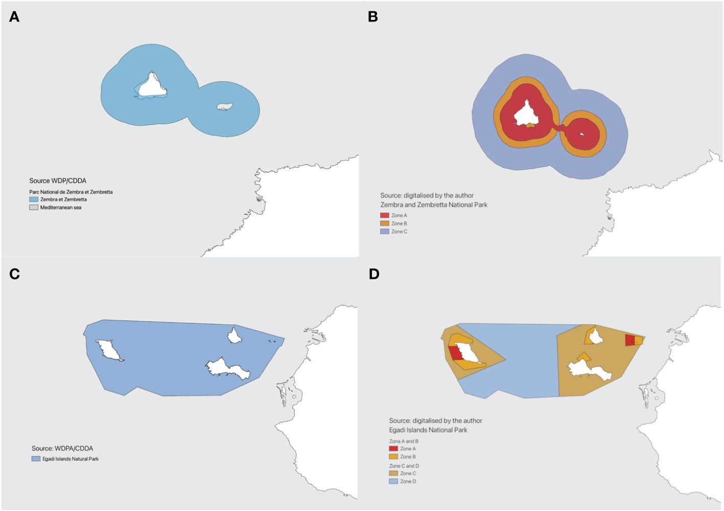
Figure 1 Boundaries of Zembra and Zembretta National Park (A, B), and Egadi Islands National Park (C, D) retrieved from WDPA (A, C), and digitalised by the authors (B, D).
All the above-mentioned databases are fundamental for assessing progress towards EU and international targets (Gurney et al., 2023). However, none of the above databases provides information on the management of each protected area and spatial data on regulated activities (Sletten et al., 2021), making the impact assessment of MPAs effectiveness and the evaluation of the above-mentioned targets/policies hard to monitor.
To highlight the gaps associated to the different levels of protection of multiple-use marine protected areas in the official databases, we focused on two specific MPAs of the Mediterranean Sea: the Egadi Island in Italy, and Zembra and Zembretta National Park in Tunisia. This selection aimed to encompass two examples with diverse socio-ecological and political contexts.
Figures 1A, C showcase spatial MPAs data retrieved from the official WDPA, while Figures 1B, D display digitalized spatial data extracted from the cartography, available in the official regulatory documents of the MPAs (mostly available in local languages).
This mapping exercise underscores the lack of critical data in management and governance features within the official database. For instance, in Zembra and Zembretta National Park (Figure 1A), the WDPA mentions a no take zone without providing its specific location and/or its extent. Similarly, in the Egadi Islands National Park (Figure 1C), the WDPA reports the boundaries for the terrestrial and marine Natura2000 area and the national Marine MPA of Egadi Islands with additional information on the designation year, and IUCN category. However, it lacks spatial data on the zoning scheme.
Contrastingly, the official regulatory documents reveal more comprehensive zoning schemes and management details. The official regulatory document of Zembra and Zembretta National Park (Figure 1B) reports Zone A and Zone B as no- take areas, covering around 36% of the total area with Zone C (around 64%) permitting regulated activities like small-scale fisheries. In the Egadi Islands MPA (Figure 1D), the official regulatory document illustrates a multiple-use area, with specific zones (A, B, C, and D) covering different percentages of the total area, each with unique regulations on activities like bottom trawling and fishing gear usage. Zone A accounts for 1,8% of the total area (540 km2), zones B and C roughly 45% of the protection, where bottom trawling is off-limits and human activities are regulated. Finally, a zone D covers around 280 km2, where bottom trawling and other fishing gears are regulated.
The lack of management measures and spatial dimension of regulated, forbidden, or allowed activities in the official databases highlighted in these examples are common for all the Mediterranean MPAs and countries, and also to other countries and MPAs globally. The absence or scattered availability, often in local languages, of this crucial regulatory data impedes the assessment of ocean protection levels and the true contribution of MPAs in preserving marine ecosystems. Such difficulties in accessing accurate information limit policy makers’ ability to make informed decisions regarding the designation, implementation and evaluation of marine associated policies.
3 Actionable recommendations
At a global level, efforts like the Protected Seas database (https://protectedseas.net/) represent an initial step to gather spatial information on regulatory data and conservation measures within MPAs (Sletten et al., 2021). The database is freely downloadable and includes GIS boundaries and an attribute table with regulatory data on human activities and additional information for each MPAs not available in other dataset. Through the navigator portal, they provide a summary of regulated and forbidden activities by area with a link, where possible, of the official management plan. It does not serve as an official database for policy purposes. Nonetheless, it provides an example for the development of a more inclusive and extensive European database. According to this database, for example considering the Mediterranean Sea and the management related to the fishery sector, there are considerable differences in the percentage of protection among its sub-regions. The West Mediterranean hosts the largest percentage of no entry areas, while bottom trawling is banned only in 10% of protected areas, and regulated in 21% of the areas. On the contrary, in the Aegean-Levantine sub-region, bottom trawling is prohibited and regulated in 20.6% and 78.8% respectively. At regional level, only 0.02% of the Mediterranean sea hosts no-entry areas and around 10% of regional protected areas are banned from bottom trawling.
The information given by Protected Sea highlights the importance of having a centralised common database to assess the current status of MPAs, and identify/tailor new evidence-based conservation strategies/measures to provide to decision makers. Since the aim and ambition of current EU and international policies is to increase and enforce marine protection, having these numbers/databases explicitly accounted for is of extreme necessity. In the past, several efforts have been made to improve the official databases, for example by collecting data from management plans, publicly available documents, legal texts; yet the collection and systematisation of regulations and related geospatial data can be labour intensive (Claudet et al., 2020), and such datasets have remained unofficial and unavailable. Having a centralised official database, that accounts for and improves features of existing databases, can reduce issues on replicability and consistency, avoiding discrepancies among the different platforms. This framework should focus on data accuracy and reliability, regular updates of management and governance information, and streamlined coordination. This implies not only a common reporting between countries but also a regular and standardized workflow among all the responsible authorities. Differences in the way of operating among stakeholders (at local, regional and global scale), might impede the correct implementation of such a database.
In order to assess the efficiency, effectiveness and comparability across MPAs, the database should include the following features: spatial zonation (i.e., boundaries of management zonation), management regulations per zonation (i.e., type of fishing gear, recreational activities, access), temporal restriction (i.e., yearly/seasonal regulation) per zonation, and conservation goals (i.e., MPA specific habitat/species preservation). In addition, it would be key to have information about governance features of the MPAs, that have been proven to be drivers of MPAs socio-ecological effectiveness (Di Franco et al., 2016; Gill et al., 2017).
The significance of spatial MPAs data extends beyond assessing existing areas. It plays a pivotal role in forecasting scenarios at regional/EU/global levels, which are currently in place to assess the implementation and evaluation of current policy measures and to support the designation of future ones (Piroddi et al., 2021; Macias et al., 2022; Piroddi et al., 2022). Missing information on spatial MPAs might negatively impact model results, increasing model uncertainty, and ultimately influence the quality of scientific advice given to policy makers.
4 Conclusion
It is now time to enhance the MPAs database framework to better assess the existing areas and guide decisions making processes by managers and policy makers for the establishment of future MPAs. This step is crucial in ensuring effective marine ecosystem preservation and sustainable management practices. This policy brief aims at stimulating international actions to enable researchers and policy makers accessing data for policy development, marine/maritime spatial planning and decision-making processes.
4.1 Data analysis
Polygons and information on marine protected areas were retrieved from the World Database of Protected Area (WDPA) [October 2023], Cambridge, UkK: UNEP-WCMC and IUCN www.protectedplanet.net
The original cartography for Egadi Island in Italy, Zembra and Zembretta National Park in Tunisia has been digitalised to highlight MPAs zoning schemes and obtain regulatory information
Navigator Data Download, ProtectedSeas®, https://navigatormap.org/data-request (last visited [September 2023]).
Author contributions
SL: Conceptualization, Formal Analysis, Writing – original draft, Writing – review & editing. CP: Conceptualization, Writing – original draft, Writing – review & editing. MG: Conceptualization, Writing – review & editing. ADF: Writing – review & editing.
Funding
The author(s) declare that no financial support was received for the research, authorship, and/or publication of this article.
Acknowledgments
We wish to thank Natalia Serpetti for helping in the conceptualization of the work.
Conflict of interest
Author SL was employed by Arcadia Sistemi Informativi SRL.
The remaining authors declare that the research was conducted in the absence of any commercial or financial relationships that could be construed as a potential conflict of interest.
The author(s) declared that they were an editorial board member of Frontiers, at the time of submission. This had no impact on the peer review process and the final decision.
Publisher’s note
All claims expressed in this article are solely those of the authors and do not necessarily represent those of their affiliated organizations, or those of the publisher, the editors and the reviewers. Any product that may be evaluated in this article, or claim that may be made by its manufacturer, is not guaranteed or endorsed by the publisher.
References
Claudet J., Loiseau C., Sostres M., Zupan M. (2020). Underprotected marine protected areas in a global biodiversity hotspot. One Earth 2, 380–384. doi: 10.1016/j.oneear.2020.03.008
Díaz S., Pascual U., Stenseke M., Martín-López B., Watson R. T., Molnár Z., et al. (2018). Assessing nature's contributions to people. Science 359, 270–272. doi: 10.1126/science.aap8826
Di Franco A., Thiriet P., Di Carlo G., Dimitriadis C., Francour P., Gutiérrez N. L., et al. (2016). Five key attributes can increase marine protected areas performance for small-scale fisheries management. Sci. Rep. 6, 38135. doi: 10.1038/srep38135
Gill D., Mascia M., Ahmadia G., Ahmadia G. N., Glew L., Lester S. E., et al. (2017). Capacity shortfalls hinder the performance of marine protected areas globally. Nature 543, 665–669. doi: 10.1038/nature21708
Grorud-Colvert K., Sullivan-Stack J., Roberts C., Constant V., Horta e Costa B., Pike E. P., et al. (2021). The MPA Guide: A framework to achieve global goals for the ocean. Science 373, eabf0861. doi: 10.1126/science.abf0861
Gurney G., Adams V., Álvarez-Romero J., Claudet J. (2023). Area-based conservation: Taking stock and looking ahead. One Earth 6, 98–104. doi: 10.1016/j.oneear.2023.01.012
Hermoso V., Carvalho S. B., Giakoumi S., Goldsborough D., Katsanevakis S., Leontiou S., et al. (2022). The EU Biodiversity Strategy for 2030: Opportunities and challenges on the path towards biodiversity recovery. Environ. Sci. Policy 127, 263–275. doi: 10.1016/j.envsci.2021.10.028
Macias D., Stips A., Grizzetti B., Aloe A., Bisselink B., De Meij A., et al. (2022). Water/marine zero pollution outlook: a forward-looking, model-based analysis of water pollution in the EU (Luxembourg: Publications Office of the European Union). Available at: https://data.europa.eu/doi/10.2760/681817.
Maes J., Egoh B., Willemen L., Liquete C., Vihervaara P., Schägner J. P., et al. (2012). Mapping ecosystem services for policy support and decision making in the European Union. Ecosystem Serv. 1, 31–39. doi: 10.1016/j.ecoser.2012.06.004
McCauley D. J., Pinsky M. L., Palumbi S. R., Estes J. A., Joyce F. H., Warner R. R. (2015). Marine defaunation: Animal loss in the global ocean. Science 347, 1255641. doi: 10.1126/science.1255641
Miller-Meehan M., Ban N., Devillers R., Singh G., Claudet J. (2020). How far have we come? A review of MPA network performance indicators in reaching qualitative elements of Aichi Target 11. Conserv. Lett. 13, 1–18. doi: 10.1111/conl.12746
Piroddi C., Akoglu E., Andonegi E., Bentley J. W., Celić I., Coll M., et al. (2021). Effects of nutrient management scenarios on marine food webs: A pan-European assessment in support of the marine strategy framework directive. Front. Mar. Sci. 8, 596797. doi: 10.3389/fmars.2021.596797
Piroddi C., Coll M., Macias D., Steenbeek J., Garcia-Gorriz E., Mannini A., et al. (2022). Modelling the Mediterranean Sea ecosystem at high spatial resolution to inform the ecosystem-based management in the region. Sci. Rep. 12, 19680. doi: 10.1038/s41598-022-18017-x
Reimer J. M., Devillers R., Claudet J. (2021). Benefits and gaps in area-based management tools for the ocean Sustainable Development Goal. Nat. Sustainability 4, 349–357. doi: 10.1038/s41893-020-00659-2
Sletten J., D'Iorio M., Gleason M. G., Driedger A., Vincent T., Colegrove C., et al. (2021). Beyond the boundaries: How regulation-centered marine protected area information improves ocean protection assessments. Mar. Policy 124, 104340. doi: 10.1016/j.marpol.2020.104340
Keywords: Mediterranean Sea, marine protected area, management and governance, regulatory activities, marine fisheries
Citation: Lippi S, Piroddi C, Graziano M and Di Franco A (2024) Highlighting the gap on spatial regulatory data in the official MPAs databases. Front. Mar. Sci. 11:1369447. doi: 10.3389/fmars.2024.1369447
Received: 12 January 2024; Accepted: 11 April 2024;
Published: 25 April 2024.
Edited by:
Lyne Morissette, M – Expertise Marine, CanadaReviewed by:
Sílvia Gómez, Autonomous University of Barcelona, SpainRafael Sarda, Spanish National Research Council (CSIC), Spain
Copyright © 2024 Lippi, Piroddi, Graziano and Di Franco. This is an open-access article distributed under the terms of the Creative Commons Attribution License (CC BY). The use, distribution or reproduction in other forums is permitted, provided the original author(s) and the copyright owner(s) are credited and that the original publication in this journal is cited, in accordance with accepted academic practice. No use, distribution or reproduction is permitted which does not comply with these terms.
*Correspondence: Chiara Piroddi, Y2hpYXJhLnBpcm9kZGlAZWMuZXVyb3BhLmV1