 Shuo Wang
 Jiaju Lin
 Xiongzhi Xue
 Yanhong Lin
95% of researchers rate our articles as excellent or good
Learn more about the work of our research integrity team to safeguard the quality of each article we publish.
Find out more
ORIGINAL RESEARCH article
Front. Mar. Sci. , 13 March 2024
Sec. Marine Affairs and Policy
Volume 11 - 2024 | https://doi.org/10.3389/fmars.2024.1337147
As the land–sea interface, the coastal zone has become an increasingly key life-support system. However, it is also highly threatened by exposure to both ocean- and land-based human activities. The interdependencies of the land and sea systems require the integration of land and sea spatial planning to achieve sustainable development of coastal zones. There are different forms of land–sea spatial management integration globally. Whether a form can positively impact and how different institutional settings affect outcomes need further explanation. Therefore, this study explores the reasons for China’s planning integration through institutional reform by using the Graph Model for Conflicts Resolution and establishes a quantitative contradiction assessment method to examine whether this top-down institutional approach has played a role at the urban level. The results show that the planning of Xiamen city after reform has a lower total contradiction value, grid cell average and cell maximum value. This progress is made possible by unifying the land–sea spatial planning departments. The equilibrium solution of the Graph Model for Conflicts Resolution indicates that due to the different preferences of the land–sea management departments and the central-local governments, it is challenging to implement the Land–sea Coordination policy under separate land–sea management. By integrating land–sea management departments, deep-seated sectoral interests between horizontal departments do not remain. The impacts on integrated management of divergences in preferences of different vertical governments can be reduced. The research results provide a universal method for the contradiction evaluation and a management reference for other regions that want to integrate land–sea coordination into urban spatial planning.
With the expansion of human demand for marine space and resources (Halpern et al., 2015; van Tatenhove, 2017; Harris, 2019), the coastal zone, as the interface between the land and sea, has become an increasingly key life-support system (Kidd et al., 2019b). However, it is highly threatened by exposure to both ocean- and land-based human activities (de Groot et al., 2002; Halpern et al., 2009; Jickells, 1998; Lindeboom, 2002). To promote sustainable development for coastal zones, governance must be integrative across diverse dimensions of land and sea systems (PAP/RAC, 2018). This is because of their interdependencies in ecosystems, resources, and socio-economic development (Valdmane et al., 2021). Spatial planning is an important field for governance to cope with social, economic and later environmental problems (Rivolin and Faludi, 2005; Douvere, 2008; Smith et al., 2011). The existing land spatial planning only stops at the shore and does not take into the impact on marine space. Meanwhile, current marine spatial planning (MSP) focuses on regulating marine activities (Loiseau et al., 2021) without considering the land planning framework (Walsh, 2021). The inconsistency between land–sea spatial planning consolidates land–sea dichotomies, resulting in conflicts in management and difficulties in sustainable development for coastal zones (Kerr et al., 2014; Zaucha and Gee, 2019; ESPON, 2020; Walsh, 2021). Therefore, how to consider land–sea interactions in planning to reduce land–sea spatial planning conflicts has become an important issue for governments globally.
To reconcile land–sea spatial planning, it is necessary to evaluate the contradictory values between them quantitatively (Wang et al., 2019). Evaluation is regarded as a management activity to determine the effectiveness of spatial planning (Khakee, 1998; Ehler and Douvere, 2009). There are many assessment methods for land or marine spatial planning. Risk assessment, ecosystem service value and life cycle assessment are often used in land use studies (Lavoie et al., 2015; Schmidt et al., 2015; Hasan et al., 2020); for MSP assessment, the cumulative impact assessment index published by Halpern et al. (2008) and its variants have been widely used, and another contradiction analysis method based on the planning scheme itself has also been continuously improved (Freeman et al., 2016; Fang et al., 2019; Ye et al., 2021; Hou et al., 2022). In this study, we introduced the contradiction analysis method to the joint assessment of land–sea spatial planning. This is a gap in current research. The advantage of this method is that it is a more forward-looking ex-ante evaluation, which is not affected by the selection of evaluation indicators, and can provide quantitative information for the spatial planning scheme itself.
Considering land–sea interactions in spatial planning is very complex because it involves natural biogeochemical processes and the scope and jurisdiction of various human activities (Smith et al., 2011; Rog and Cook, 2017; Kidd et al., 2019a). Achieving administrative integration depends on updating legislation or institutional arrangements (Zaucha and Gee, 2019; Kidd et al., 2019a). There are institutional arrangements in different regions to respond to the problems posed by land–sea interactions. The MSP Directive published by the European Union in 2014 stipulates that Member States shall make land–sea interactions a minimum requirement of MSP. Countries along the Mediterranean Sea are required to implement integrated coastal zone management to solve the problem (Ramieri et al., 2019; Kidd et al., 2019a); the UK still implements independent land and sea planning. However, considering a series of jurisdictional issues brought about by land–sea interaction is required; and a more integrated planning approach calls for encompassing both land and marine areas was taken by the Netherlands and Ghana (Kidd et al., 2019a; Iglesias-Campos et al., 2021). However, these practices are more like a “repair” for the original planning, requiring a long cycle to work.
Unlike the aforementioned countries, China has adopted a “rebuild” approach to reduce contradictions between land–sea spatial planning. China proposed the concept of Land–sea Coordination (LSC) in 2004 (Yue et al., 2023). However, the land and the sea were separately managed by different bureaus before 2018, and many contradictions exist between the land and marine spatial planning systems (Zhao and Jia, 2019). Therefore, the LSC policy has not been well implemented. In 2018, the State Council implemented a new round of the institutional reform, with the land and the sea under the newly established Ministry of Natural Resources. The various original land spatial planning and MSPs were integrated into territorial spatial planning (TSP) to reconcile the land–sea contradictions (Wang and Chen, 2019). Currently, institutional research on coordinating land–sea spatial planning mostly stays at the level of “how to achieve it”, but limited research has revealed why a country or region makes its choice regarding institutional arrangements.
There are many forms of land–sea spatial planning integration, but the effect of different integration approaches depends on the institution’s leadership and its power, knowledge and related configurations (Pelling et al., 2008; O’Hagan et al., 2020). Based on the above discussion, this study aims to conduct a contradictory assessment of the land–sea spatial planning before and after China’s institutional reform to estimate whether this transformation is effective. Then, by introducing the Graph Model for Conflicts Resolution (GMCR), an in-depth analysis of the reasons for China’s choice of institutional arrangements for coordinating land–sea spatial planning is carried out. The innovation of this study lies in (1) a universally applicable method for quantitatively evaluating contradictions in land–sea spatial planning that was constructed and applied to Xiamen and (2) the application of the GMCR to an analysis of LSC governance options.
In 2018, the Chinese Mainland implemented top-down institutional reforms aimed at the functional integration of departments. The institutional reform led to the reform in the territorial spatial planning system. The State Oceanic Administration, which was in charge of formulating the national MSP, was abolished, and the functions on spatial planning of the Ministry of Land and Resources, National Development and Reform Commission, and Ministry of Housing and Urban–Rural Development were unified into the newly established Ministry of Natural Resources. The various original land spatial planning and MSPs were integrated into TSP, which is issued by natural resources departments at all levels. The TSP includes overall planning, detailed planning and related special planning, among which coastal zone special planning is required for the coastal zone (Wang and Chen, 2019). Governance of land–sea spaces shifts from fragmentation to integration, although the transformation is still in progress. We selected Xiamen as the research area, and compared the contradictory values of land–sea spatial planning before and after the reform.
Xiamen is a city born by the sea in southeastern China, adjacent to the Taiwan Strait (Figure 1). By 2021, Xiamen had a land area of 1,698.78 km2 and a sea area of approximately 390 km2, with a resident population of 5.28 million. Its urban core grew up from southern Xiamen Island. Xiamen Island lies about one degree north of the Tropic of Cancer. The north is Huli District, and the south is Siming District. Its mainland territory is divided among Haicang, Jimei, Tong’an, and Xiang’an districts.
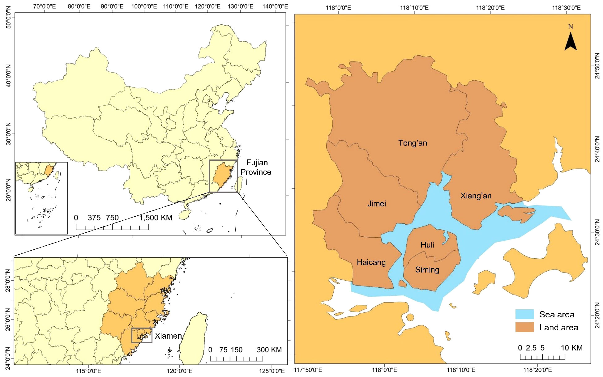
Figure 1 The location of the study area.
Over the past decade, Xiamen’s permanent population has increased by 1.64million. After the census in 2020, the population density of Xiamen is about 3,105 people per square kilometer, ranking fourth in the Chinese Mainland. The GDP of Xiamen has increased from 281.71 billion yuan in 2012 to 780.27 billion yuan in 2022. Besides, the proportion of Xiamen’s Gross Ocean Product to GDP has increased from15.1% in 2016 to 29.77% in 2021 (XMBS, 2013, 2023). With the rapid development of the population and economy, large numbers of forests, farmland and wetlands have been turned into developed land (Lin et al., 2013), and reclamation activities have begun to prevail. The impacts of human activities on the coastal ecosystem of Xiamen continue to increase (Lin et al., 2013; Liu et al., 2021). Therefore, reasonable land–sea spatial planning is crucial to Xiamen’s intensive and efficient use of territorial space and resources in Xiamen.
In this study, the data we used were mainly spatial data. They were collected from the Xiamen Master Plan (2003–2020), Xiamen Marine Functional Zoning (2013–2020), Master Plan for National Nature Reserve of Xiamen Rare Marine Species and Comprehensive Coastal Zone Protection and Utilization Planning of Xiamen Territorial Spatial Planning (2021–2035) (Draft). All the above plans can be found on the website of the Xiamen Municipal Bureau of Natural Resources and Planning (http://zygh.xm.gov.cn/). We vectorized these plans through ArcGIS10.6 for spatial analysis.
Before and after the reform of spatial planning system, the names of functional zones changed. Therefore, we first compared the types of functional zones before and after the reform. Before the reform, the division of the land functional zones is mainly determined by Xiamen Master Plan (2003–2020), which contains 12 functional zones. The division of functional zones in the sea area is mainly planned by Xiamen Marine Functional Zoning (2013–2020). There are 7 first categories of marine plane functional zones. Besides, there are three rare marine species, namely Chinese white dolphins, amphioxus and egrets. In this study, we only considered the core zones of the nature reserve for these three species according to the Master Plan for National Nature Reserve of Xiamen Rare Marine Species, and did not include the outer areas, because the outer areas basically cover all the sea areas under the jurisdiction of Xiamen. After the reform, various natural resources, including land and sea, were treated as a whole, so various plans were merged into one to balance and achieve multiple planning objectives on a map. The new integrated coastal zone planning of TSP covers sea areas and islands under the jurisdiction of the provincial government’s seaward (12 nautical miles) and covers the land under the jurisdiction of coastal county-level governments landward.
According to the Table 1, a conflict matrix of land–sea activities is constructed using the expert scoring method (Table 2). We consulted six experts in MSP through an electronic questionnaire, and the final score was the average of their respective scores. Among them, the leisure green space (L4) corresponds to the ecological green space (L41) and the public green space (L42) before the adjustment, so the conflict value between the leisure green space and the sea use activities is the average value of the ecological green space, the public green space and other sea-use activities. The comprehensive service zone (L8) has also been treated similarly. Although the marine reservation zone always exists in the two marine functional areas before and after the adjustment, the marine reservation zone before the adjustment (M4) is for protection. In contrast, the adjusted marine reservation zone (M8) belongs to the second-level activity of the marine development zone. Therefore, we classify the adjusted marine reservation zone as a new category. Moreover, we regarded the marine protected zone in the MFZ and the national marine nature reserve as one category (M3), with the same value settings when calculating the contradictory values. Since the newly added functional zones will not conflict with the non-existing functional zones after adjustment, some pairs are not assigned values.
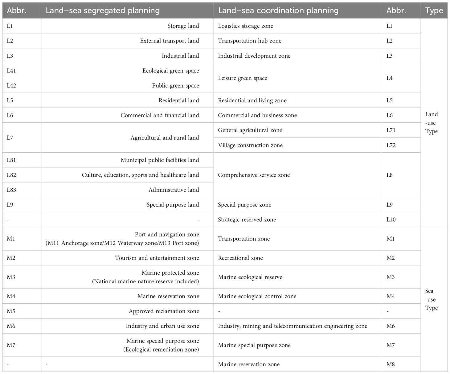
Table 1 Comparison of land–sea functional zones before and after adjustment.
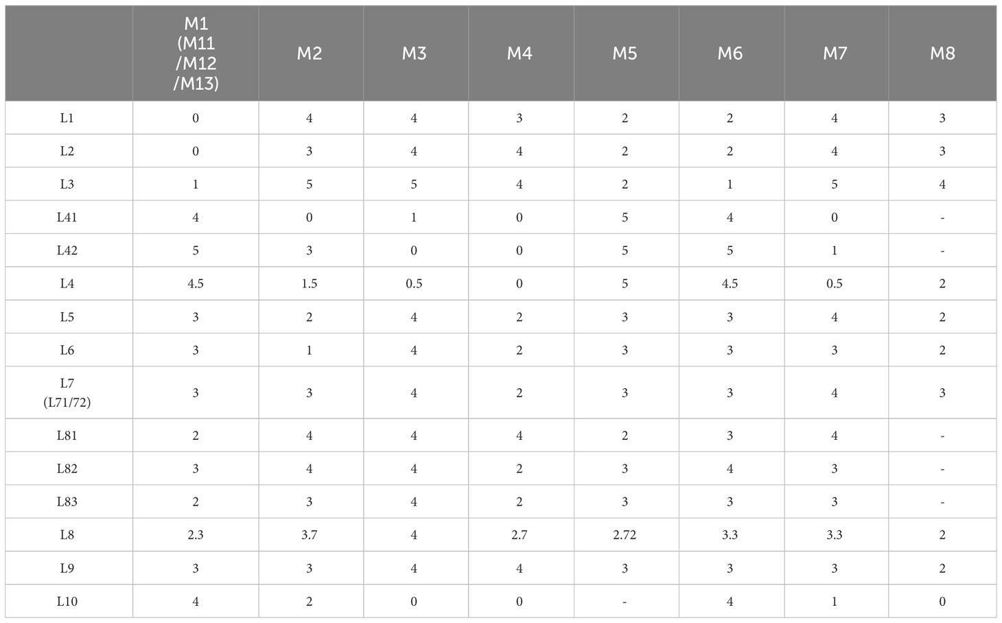
Table 2 The contradictory intensity values between land use and sea use activities.
Quantitative analysis of the buffered overlapped areas in different functional zones has been widely used in calculating conflicts in the MFZ scheme itself (Fang et al., 2019; Hou et al., 2022; Yang et al., 2022). Such analysis is usually done through ArcGIS. Therefore, this study established a buffer zone with a radius of 300 m based on land and sea functional zones and determined the overlapping area between land–sea functional zones in pairs (the intersection processing of land–sea functional zone buffers was carried out). Then, the overlapping area of buffers in each pair of land–sea functional zones is converted into a raster layer with a grid unit size of 20 m × 20 m. The total contradictory value can be obtained by accumulating the products of grid numbers and conflicting values between different pairs (Equation 1). The average of each cell is the total contradictory value divided by the number of units (Equation 2).
where is the total contradictory value of land–sea spatial planning; is the contradictory value of the unit grid; is the number of grids corresponding to different contradictory values; is the average value of the unit grid; and is the number of total grids.
In this study, we used the GMCR to analyse the game relationship between the land–sea spatial planning departments before and after the institutional reform. GMCR is a method to model, analyse and represent conflicts, which is developed on the basis of classical game theory and metagame theory (Fang et al., 1993; Yu et al., 2015). It is a systematic and flexible methodology that can analyse strategic conflicts in the real world (Fang et al., 1993, Fang et.al, 2003a). It is also a non-cooperative game and can accurately describe the behavior of different decision-makers (Kilgour et al., 1987; Dowlatabadi et al., 2020). Compared with other game theory models for analysing strategic conflicts, GMCR is more convenient to use in practice.
The GMCR consists of four elements. Suppose is the set of decision-makers, is the set of feasible states for decision-makers, and is a set of directed arcs in . Hence, can be defined as a graph model, and , denotes a directed arc starting from its tail to the head . The arcs for decision-maker are the Cartesian product of two sets of states . The preference for decision-makers is defined as the ordinal relation between each pair of states. The preference ranking for a decision-maker is denoted using (strict preference), (weak preference), and (indifference) (Fang et al., 2003b; He et al., 2014; He, 2015). Thus, a graph model can be defined as the following equation (Equation 3).
The hierarchical GMCR model before the institutional reform (Model 1), which is used to analyse the existence of land and sea planning conflicts, has four decision-makers: the Central Government (CG), the Local Government (LG), the Local Department Responsible for Land Spatial Planning (DL) and the Local Department Responsible for Marine Spatial Planning (DM). There are two sub-conflicts, one between the CG and LG and the other between the LG, DL and DM. After the institution reform (Model 2), only three decision-makers were involved, namely the Central Government (CG), the Local Government (LG) and the Local Department of Natural Resources (DNR). The two sub-conflicts are between CG and LG and between LG and DNR. Table 3 integrates the information of Model 1 and Model 2. “Y” in the status quo column represents the initial state.
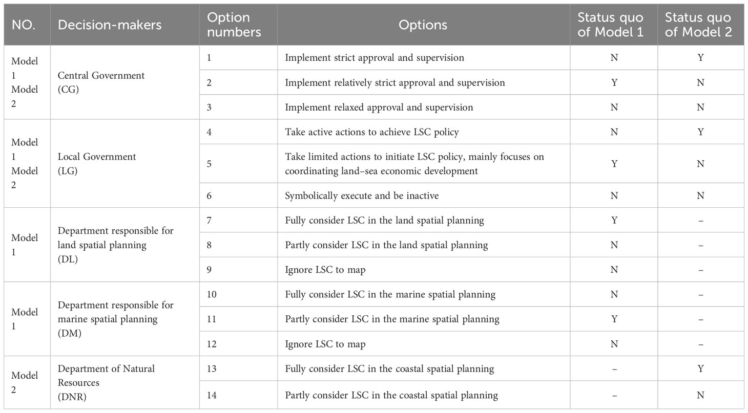
Table 3 Options of decision-makers and status quo state in Model 1 and Model 2.
Options are actions that a decision-maker may take in a conflict. In Model 1, each decision-maker has 3 choices. There are 212 states in this model. Given that some options mentioned above are impossible to occur simultaneously, they were discarded. Finally, only 57 states were considered (Supplementary Table A.1). In Model 2, CG and LG still have the three options from Model 1. The newly established DNR can hardly ignore the LSC policy, which is determined by its departmental responsibilities. Therefore, it only has two options of fully considering LSC and partly considering LSC in planning. There are 28 states, of which 239 were removed, and we analysed the stability of the remaining 17 states (Supplementary Table A.2).
In Model 1, CG wants LG to follow the principle of LSC and balance the two goals of economic development and eco-environmental protection. At the same time, it wishes to pay fewer supervision costs, while LG hopes that CG will give fewer “prescribed actions” but more room for “optional actions”. In the sub-conflict between LG, DL and DM, LG places more emphasis on the development of local economies, including land and sea economies. DLs insist that land is more important, and regard marine resources as a supplement to ignore the LSC policy. The sea is in a relatively inferior position compared to the land, especially regarding eco-environmental protection and resource development efficiency. Land-based pollution, reclamation and other activities have caused tremendous pressure on marine protection. Therefore, DM hopes that the sea and land will be treated as equally important to protect the marine eco-environment better and achieve sustainable development of the marine economy. In Model 2, the preferences of LG and CG do not change. As a department performing the responsibility of the owner of natural resources, the DNR needs to take into account the protection, utilization and development of various resources, so it tends to fully incorporate LSC into the planning. The decision-makers and their options are listed in Table 4.
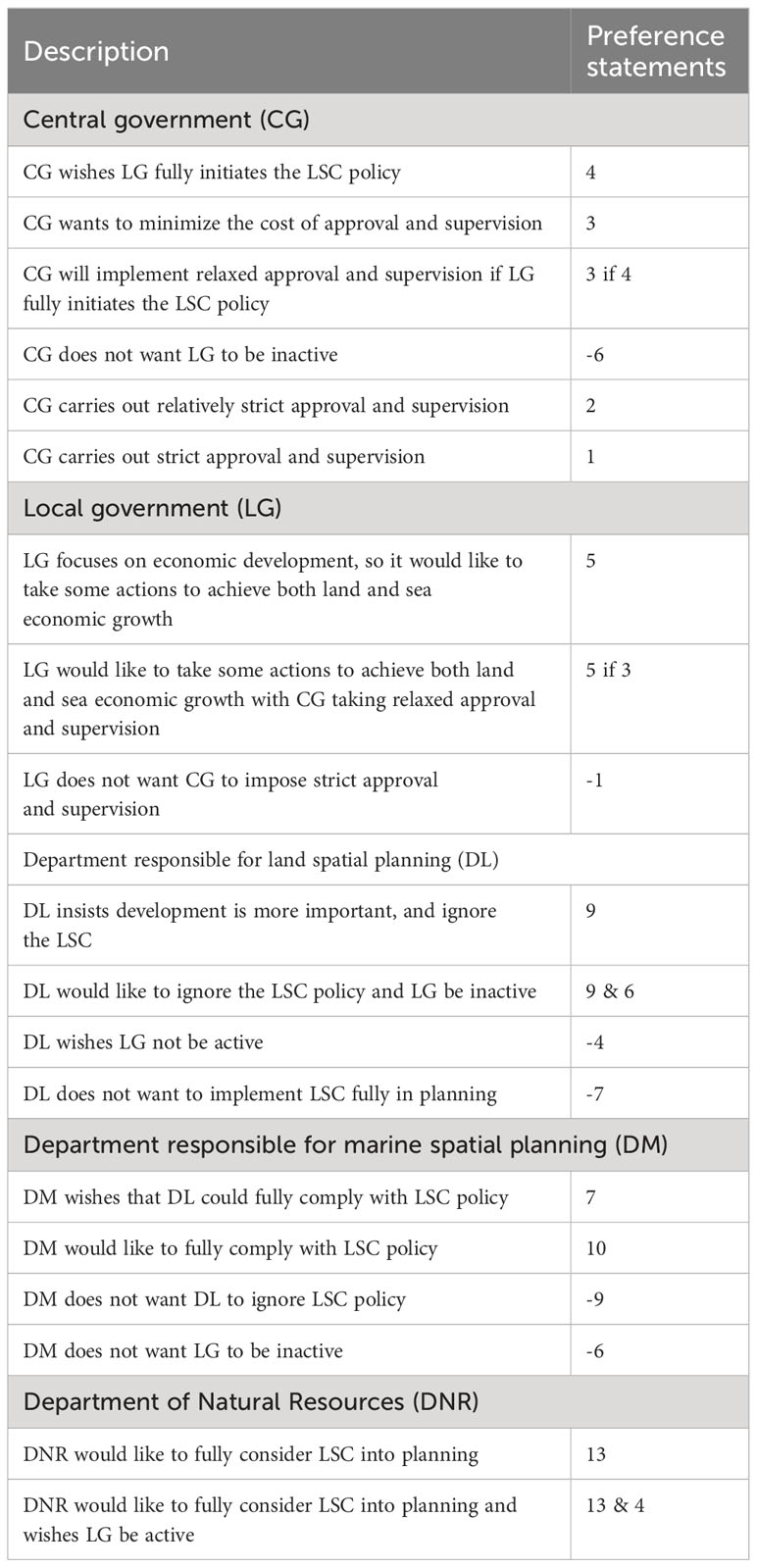
Table 4 Preference statements for decision-makers.
Conflict stability analysis is performed by determining the stability of each state for each decision-maker (Fang et al., 2003b). However, the stable state is different under different solution concepts. Nash stability is also SEQ, GMR and SMR stability. It or SEQ is considered a strong equilibrium, which means it is more likely to happen in reality, while others are less likely to happen (He, 2015).
According to the planning before adjustment, the port and navigation zone can be divided into three sub-types: anchorage, waterway and port zones. We examined the conflict situations of these three sub-type activities separately. A total of 12 land-use activities and 9 sea-use activities (national natural reserve and marine protected zone are regarded as the same sea-use activity) were analysed. The overlapping area of all land–sea functional zone pairs is 364.560 km2. Using ArcGIS for raster overlay, the cumulative value of all conflict values is 2,165,800. The highest value of the raster is 71, which is located in the Haicang area (Figure 2A). The high values of Xiamen Island are mainly distributed on the southwest coast (Siming District), especially in the area towards Gulangyu Island. Undoubtedly, the mean contradiction value of Siming District is the highest. In contrary, the mean contradiction value of Xiang’an District is the lowest, and the mean value of the whole study area is 6.621 (Figure 3).
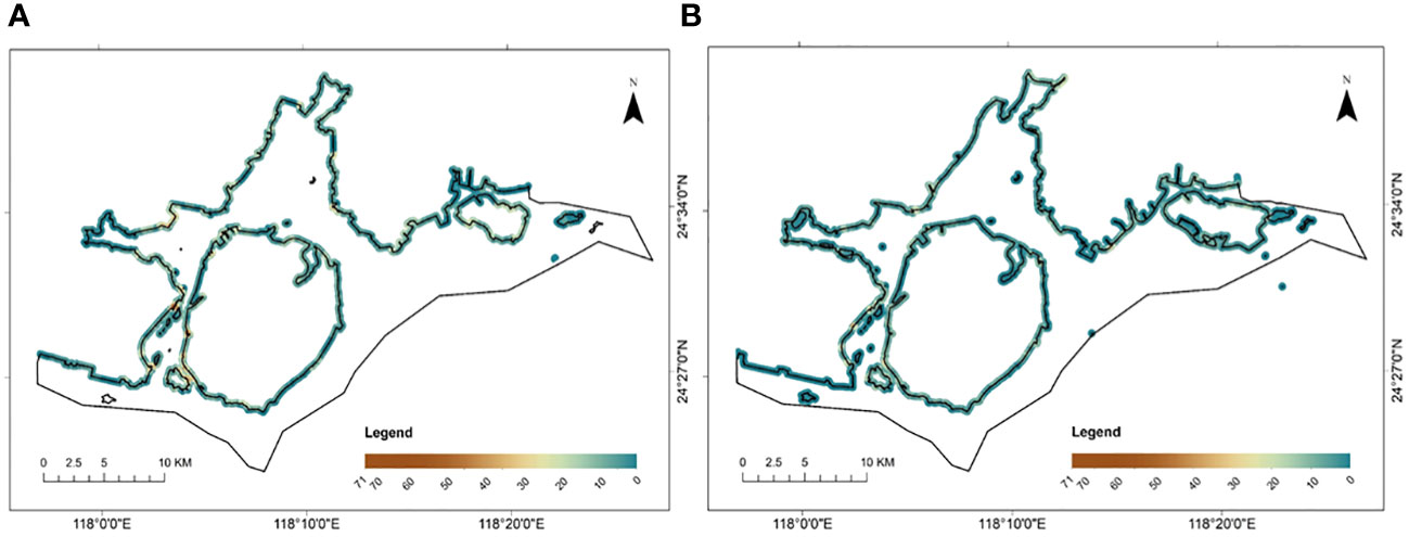
Figure 2 Land–sea contradictory value calculated by grid superposition. (A) under segregated land–sea spatial planning; (B) under integrated land–sea spatial planning.
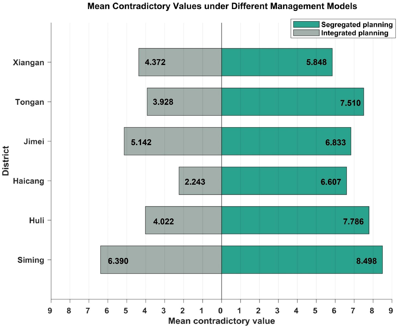
Figure 3 The mean contradictory values before and after the planning reform of each district.
Regarding quantity, the buffers of public green space and culture, education, sports and healthcare land overlap with those of all 9 kinds of marine functional zones. Storage land is the least and only overlaps with 4 kinds of sea use activities. Among the marine functional zones, the port zone, tourism and entertainment zone, approved reclamation zone and national natural reserve overlapped with 12 land use types in the buffer zone (Figure 4).
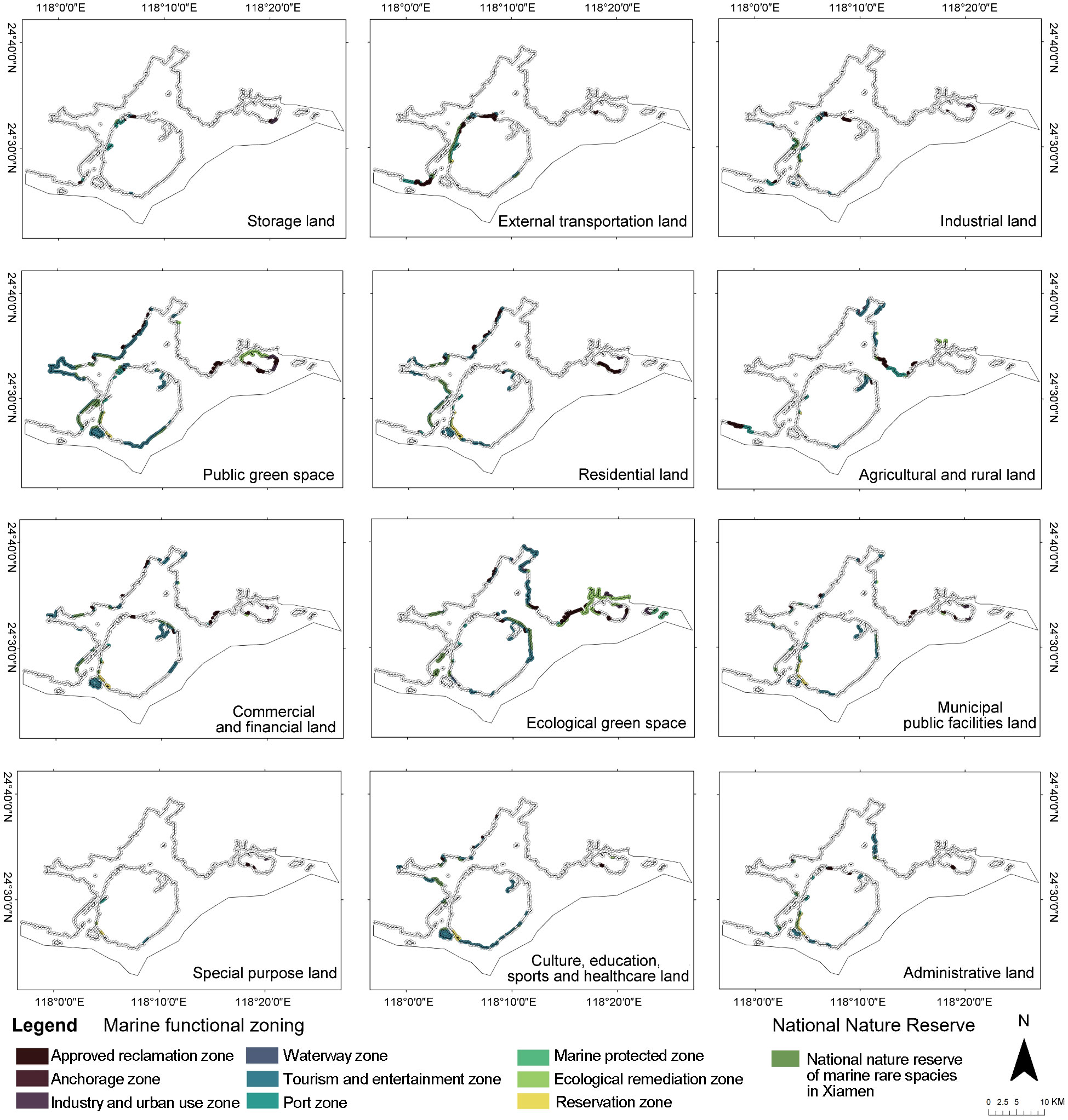
Figure 4 Overlapping area of buffer zones between land and marine functional zones under segregated land–sea spatial planning.
According to the conflict evaluation results, the largest overlapping buffer area among land–sea functional zones is public green space and tourism and entertainment zones, with an area of 35.065 km2. This is followed by ecological green space and tourism and entertainment zones, with an area of 21.393 km2. The overlapping areas of more than 10 km2 of land–sea functional pairs include commercial and financial land-tourism and entertainment zones, culture, education, sport and healthcare land-tourism and entertainment zones and residential land-tourism and entertainment zones. Undoubtedly, the marine functional zone with the largest overlapping areas with the land functional zone is the tourism and entertainment zone, with a total area of 133.33 km2. Public green space and ecological green space have the largest overlapping areas with marine functional zones, which are 69.336 and 60.820 km2, respectively. This is mainly because they have the largest areas in this study area. Special land is the land use type with the smallest overlapping area with the marine functional zones, and the total area is 2.279 km2, while the anchorage zone is the sea use type with the smallest overlapping area with the land functional zones, which is 0.303 km2.
After taking into account the conflict value of the land–sea functional zone pair, the total conflict value between the public green space and the approved reclamation zone is the largest, which is 195,455, followed by the ecological green space and the approved reclamation zone, which is 169,500. The land activity type with the highest contradiction value with the marine functional zones is the ecological green space (467,602), even though the conflict values between it and marine protected zone and ecological remediation zone are considered to be 0. From the type of marine functional zones, the total value of the conflict between the approved reclamation zone and tourism and entertainment zone, and all land functional zones ranks in the top 2. Although the overlapping area between the approved reclamation zone and land functional zones is only 57.790% of the tourism and entertainment zone and land functional zones, it is considered to have relatively large conflicts with other land use activities. It is worth mentioning that although there are buffer conflicts between marine protected zones and 6 types of land use, the overlapping area is small (4.020 km2), and the total conflict value is 1.921. However, the national natural reserve overlaps with 12 land use types, and the overlap area is 108.227 km2; the conflict value with residential land is the largest, which is 59,504. The contradictory values between each pair of land–sea functional zones can be seen in Figure 5A.
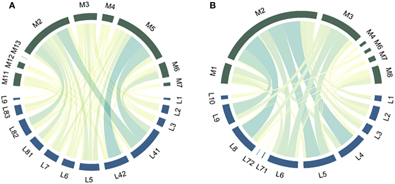
Figure 5 The contradictory values between each pair of land–sea functional zones. (A) under segregated land–sea spatial planning; (B) under integrated land–sea spatial planning.
For the adjusted integrated planning, we analysed 11 land-use activities and 7 sea-use activities. The sum of the buffer overlap area of the land–sea functional zones is 271.207 km2. The total conflict value is 1,557,819.396, the average value of each cell is 4.258, and the highest value after the raster overlay using ArcGIS is 37.700. The grids with high contradiction values (≥18) are concentrated on the west side of the Xiamen West Sea area, that is, the east coast of Haicang District, the southwest of Xiamen Island, the southeast of Jimei District, the Xiatanwei Wetland Park in the Northeast Sea area (located at the junction of Tong’an District and Xiang’an District) and the south of Xiang’an District (Figure 2B). From the average of each district, Siming District is still the highest. Although the highest value of the whole study area is located in Haicang District, its average value is the lowest, and compared with the previous value, it has dropped the most. The mean contradiction value of Xiang’an District decreased the least, and its average value changed from the least before adjustment to only behind Siming and Jimei Districts after the reform (Figure 3).
In terms of quantity, most land-use activities overlap with 5–7 sea-use activities in the buffer zone. The general agricultural zone and the village construction zone only overlap with the marine recreational zone. From the perspective of sea use activities, most of the marine functional zones overlap with the 7–9 land functional zones. The recreational zone overlaps with 11 types of land activities.
The area with the largest overlap with the buffer zone of the marine functional zone is the leisure green space, which is 64.928 km2, accounting for 23.9% of the total overlapping area; the second is the commercial and business zone, which is 58.302 km2. The recreational zone is the only marine functional zone with an overlapping area of more than 100 km2 with the land functional zones, with an overlapping area of 156.848 km2, accounting for accounting for 23.9%. The second is the marine ecological reserve, whose overlapping area with terrestrial activities is 45.006 km2 (Figure 6).

Figure 6 Overlapping area of buffer zones between land and marine functional zones under integrated land–sea spatial planning.
From the perspective of the land functional zone, the conflict values of the residential and living zone, the commercial and business zone, the comprehensive service zone, the leisure green space and marine functional zones rank in the top 4, accounting for approximately 18.6%, 17.2%, 16.5% and 16.2% of the total conflict value, which are much higher than the conflict values between other land use types and marine functional zones. Among them, the overlapping area of residential and living zones is the highest, which is 290,183. Among marine functional zones, recreational zones are still the type of sea use with the highest conflict value with land-use activities, with a conflict value of 826,180.500, which is approximately 53% of the total value of land–sea planning conflicts. The proportions of contradictory values between each pair of land–sea functional zones can be seen in Figure 5B.
It can be seen from Figure 2 that the overall land–sea conflict value of the adjusted planning has dropped significantly. The total contradiction value decreased by 607,980.604, the average value of the unit decreased by 2.363, and the maximum value declined by 33.300. The averages of all districts also fell. Coastal spatial planning may be more effective in promoting LSC than separate land–sea spatial planning.
From the changes of Xiamen City’s 6 administrative districts, before and after the adjustment, the average contradiction value of Siming District is always the highest because it is the earliest developed urban center in Xiamen, gathering a large number of population and development activities. The average value in Haicang District is the second lowest and the lowest before and after the reform, and the value decreased the most, even though the highest values under the two kinds of planning both appear in this region. The eastern shore of Haicang District has developed into the center of the region. The area of development activities is small, but there are many types, resulting in high contradiction values. In the south of Haicang District, the types of land and sea are simple. Especially after the adjustment, the compatibility of land–sea activities become higher, greatly reducing the contradiction value in this area. The development activities may cause an increase in the average contradiction value of Xiang’an District. The development of Xiang’an District has only begun in recent years, and a large amount of agricultural and rural land and ecological green space have been used for urban development. Comparing the average value of Xiang’an District before the reform, which is the lowest, with the average value of all districts after the reform, this value is the second highest, only behind Siming District. This change shows that the conflict value of each district has also dropped significantly.
By constructing GMCR models in the case of land–sea separate management and integrated management, the stability analysis of the models is analysed by using GMCR II software, and the equilibrium states are found. As shown in Table 5, State 18 is the strong equilibrium of Model 1, while State 17 is the weak equilibrium. For Model 2, the strong equilibrium is State 5, and the weak equilibrium is State 3. In Figure 7, no arrows point from strong equilibrium points to others. This means that decision-makers cannot move away from these states. All results of the analysis of the two models can be found in Supplementary Tables A.1, A.2 in the Supplementary Material.
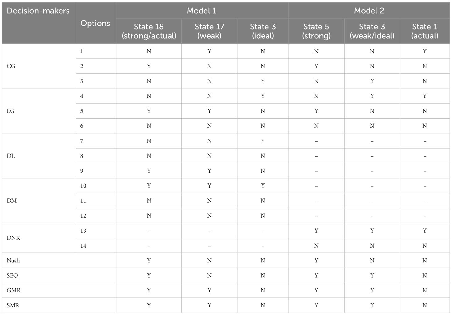
Table 5 The equilibria with options of all decision-makers for Model 1 and Model 2.
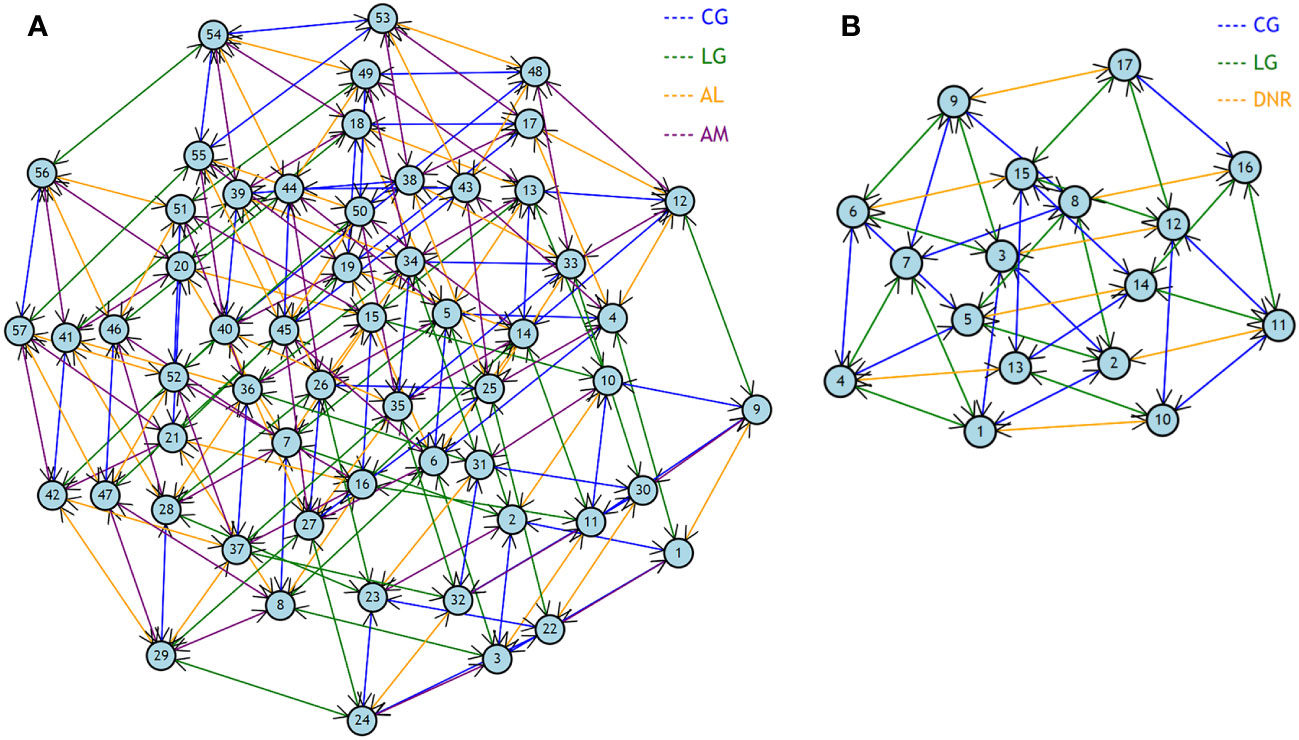
Figure 7 Graph model for conflicts. (A) Model 1: under segregated land–sea spatial planning; (B) Model 2: under integrated land–sea spatial planning.
According to the equilibrium analysis results of Model 1, in the case of land–sea separation governance, the CG will take some approval and supervision measures while the LG always takes the development of the local economy as the uppermost goal. Some of the actions taken by LG are, on the one hand, to respond to the requirements of the central government and, on the other hand, to coordinate the land–sea economy to achieve higher local GDP. However, the effects of such actions are often limited in environmental protection. In this case, DL is bound to treat marine resources as a supplement for land economic development, ignoring the need for marine development and protection, and thus carrying out reclamation, sewage discharge and other activities affecting the sea. For AM, marine environmental protection needs to address the problem of land-based pollution, and marine development needs to rely on more land-based development technologies, talent, information and other resources. Therefore, AM tends to incorporate the LSC policy into planning. The strong equilibrium point (State 18) of Model 1 is consistent with the actual situation before the institutional reform. This shows that the model can reflect reality well.
The weak equilibrium point (State 17) differs from State 18 in the choice of CG. In State 17, the central government opted for strict supervision and management. This means it needs to pay more costs, which is not CG’s Nash stability. State 3 is ideal, where LG will voluntarily push the LSC policy without strict CG supervision. At the same time, DL and DM also attach great importance to LSC and can consciously reduce the conflict between land–sea spatial planning. Only the CG and DM reach the Nash equilibrium. The post-analysis of States 3 and 18 shows that State 3 is not reachable for State 18 by solely unilateral improvement. Similarly, the state points (State 1, 2, 4, 5, 6, 7 and 8) that only require DL and DM to fully consider LSC in planning without considering the choice of CG and LG cannot be reached. It can be seen from the equilibrium states of the model that the LSC policy cannot be well implemented in the case of separate land–sea management. The final strong equilibrium state of the model is consistent with the reality before the reform, which shows that the model setting is reasonable.
In Model 2, decision-makers include CG, LG and DNR, where DNR conducts unified land–sea zone planning. State 5 is the strong equilibrium point of the model. CG implements relatively strict approval and supervision, and LG still pays more attention to the local economic development. The local DNR chose to fully incorporate the LSC into the coastal spatial planning. The weak equilibrium (State 3) point is undoubtedly the ideal state. CG pays the lowest regulatory cost, and LG actively cooperates and mobilizes resources to better help DNR implement LSC in planning. However, State 3 is not a Nash equilibrium point for LG. In reality, State 5 is more likely to be achieved than State 3. China’s territorial spatial planning reform has not been implemented for a long time, and few regions have officially announced their planning. The current situation coincides with State 1. That is, CG has adopted strict approval and supervision so that LGs have to take more action to implement the LSC policy, especially in the ecological environment. After the transition from land–sea separation planning to comprehensive territorial spatial planning, it will likely evolve to State 5.
The contradiction evaluation method has been widely used in the evaluation of MSP schemes (Freeman et al., 2016; Ye et al., 2021; Hou et al., 2022; Yang et al., 2022), but this is the first time it has been applied to evaluate land–sea planning. The benefits of focusing on land–sea interactions in planning have been highlighted (Stoms et al., 2005; Álvarez-Romero et al., 2011; Kerr et al., 2014; Loiseau et al., 2021), and we validate this view from the perspective of planning scheme evaluation based on ex-ante evaluation. Next, we innovatively use the GMCR model to analyse why China has incorporated land–sea interactions into spatial planning through institutional reform. After the institutional reform in 2018, with the end of the dual division of land–sea governance, land–sea integration is regarded as an essential principle of spatial planning. How to realize the integration of land and sea in national space planning has become a research hotspot (An et al., 2019; Yue et al., 2019; Li X. et al., 2020; Li Y. et al., 2020b). However, the reason for restructuring the spatial planning system through institutional reform seems to be ignored.
Formal or informal institutional arrangements are essential for incorporating land–sea interactions into management principles (Singh et al., 2021; Spijkerboer, 2021). Analyzing this process requires a discussion of the relationship between the governing agents (Cao and Chang, 2023). Before implementing institutional reform in 2018, China identified 28 pilot cities with integrated planning in 2014, and Xiamen is one of them. In the studies on the above pilot cities, the dilemma that “integrated planning” cannot be implemented is mentioned repeatedly, and the reconstruction of the spatial system has been proposed many times (Wang and Wei, 2015; Xie and Wang, 2015; Zhou et al., 2017), which coincides with the concept of strategic spatial planning (Albrechts, 2004; Albrechts, 2006). The reason why this “integrated planning” cannot be implemented is because there has been no change at the national level, and the original planning system and management model have not been changed (Wang and Wei, 2015). In the GMCR model, many vital management issues are reflected in the preference ranking of every decision-maker. First, before the reform, different plannings have different logical starting points and management systems. Land planning places more emphasis on development but pays little attention to the impact of land-based pollution on the marine eco-environment (Cheng et al., 2016; Li and Wu, 2017; Sun et al., 2021). The land and sea departments in local areas are not accountable to each other. Before the reform, the National Development and Reform Commission, the Ministry of Land and Resources, and the Ministry of Housing and Urban–Rural Development could issue land planning within their purview (Zhou et al., 2017) (Figure 8). For the protection and development of resources, it may not be based on scientific evaluation and development needs, but on the willingness of arm-wrestling champions. The complication is that the local functional departments accept leadership not only from the government at the same level but also from their respective higher-level business units. This top-down land–sea dual management model increases the cost for local governments to boost interdepartmental interconnection. After the institutional reform in 2018, the Ministry of Natural Resources performed the responsibilities of owning all natural resource assets, managing all territory use, and protecting and rehabilitating the eco-environment uniformly. This presents an opportunity to advance the resolution of planning conflicts. Second, the central government and local governments have different development goals. Local governments place more emphasis on local economic development (Li X et al., 2020). For some policies issued by the central government, local governments will adopt a symbolic implementation method to address supervision (Xu and Gao, 2017; Tan and Mao, 2021). The unified management of land and sea resources cannot solve all the problems caused by the central-local game. However, when the ownership, use and protection rights of natural resources are concentrated in the same department, and the Ecological Environment Departments at all levels act as supervisors, the management departments for natural resources at all levels need to consider how to balance the development and protection of various natural resources. This is a golden mean for both the central government and local governments.
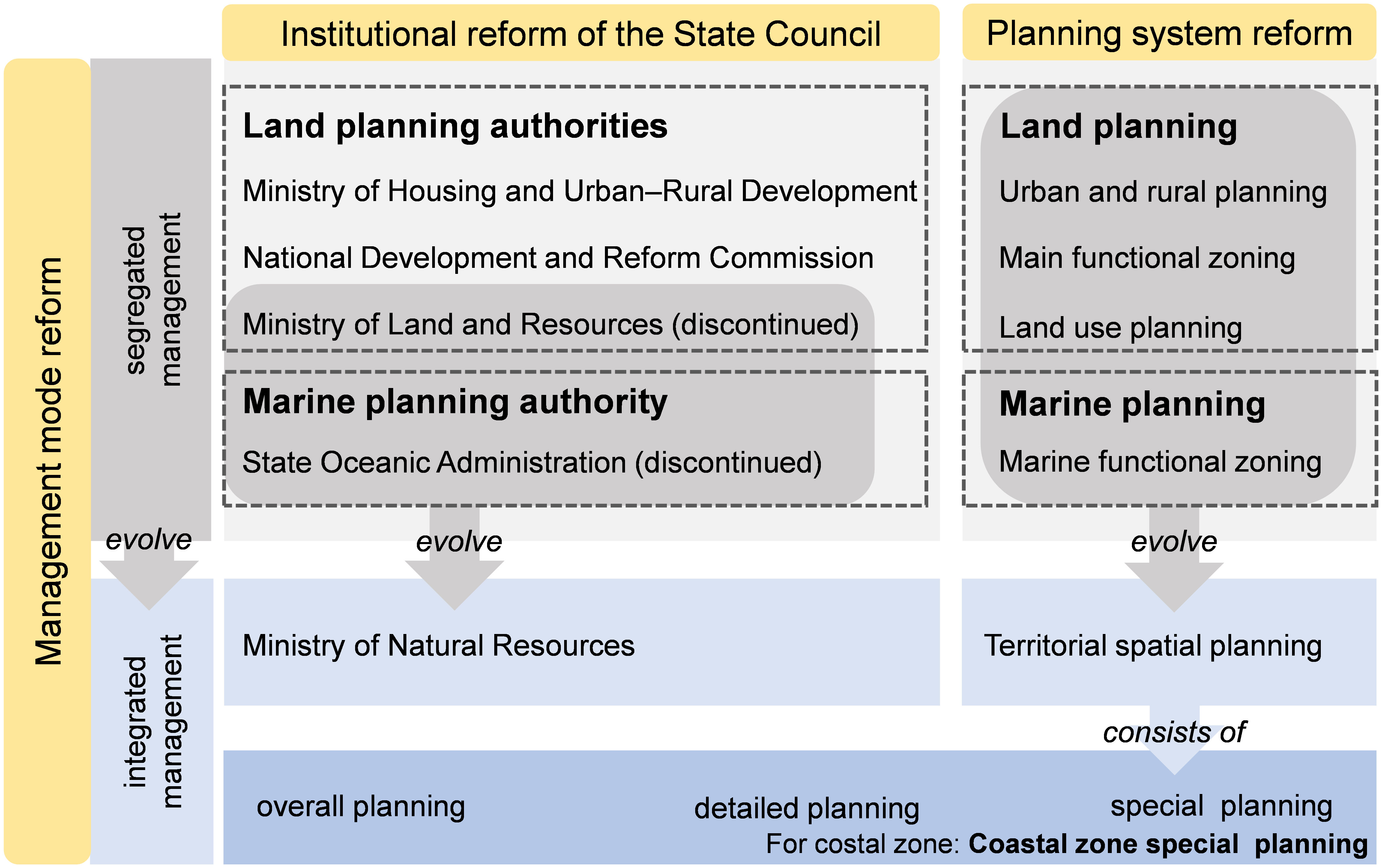
Figure 8 Changes in planning authorities, types and management models before and after institutional reform.
As a pilot city, Xiamen has much experience forming “integrated planning”, such as unifying primary data, determining protected elements, coordinating cross-affairs. These experiences are conducive to incorporating land–sea interactions into spatial planning. Specifically, the decrease in contradictory value of the adjusted planning is because in forming the coastal spatial planning in Xiamen, the ecological sensitivity of land and sea was evaluated, and different grades were delineated. Then, the potential development factor is used to conduct superposition analysis to determine the development potential of different regions. The division of functional zones was based on the results of these two evaluations. The reason for the decrease in the adjusted planning contradiction value may also be the cancellation of the sea type named the approved reclamation zone (Yue et al., 2019). Since 2018, China has halted almost all reclamation projects (Miao and Xue, 2021). Before 2018, reclamation was in full swing, which can obtain higher land-use profits at lower sea reclamation costs (Wang et al., 2014; Lin, 2022). Dadeng Island in Xiamen has been the site of the most intensive reclamation in recent years to build an international airport. In the new coastal spatial planning, no type of sea use is named the approved reclamation zone, and the reclaimed part is basically incorporated into land resources and used. In the planning before the adjustment, reclamation was considered by the experts consulted to have great conflicts with many land use types. This change in this kind of space resource also resulted in a decrease in the conflict value. In the calculation of the adjusted planning, this study does not regard them as the type of reclamation but assigns values according to the type of use in the new planning because the ecological restoration for the problems caused by reclamation is being done simultaneously.
The limitation of this study is that we only considered the contradiction between land–sea functional pairs and did not consider the suitability between the intensity of human activity and the eco-environment of land and sea. The sustainability of the eco-environment is absolutely a vital element of LSC. For example, the unit conflict value between the industrial development zone (L3) and the industry, mining and telecommunication engineering zone (M6) is 0. However, the land area and sea area under the influence of this land–sea functional pair must face enormous eco-environmental pressures. Second, since Xiamen’s Territorial Special Planning has not been officially released, we can only use the draft for this comparative study, but the planning will not be changed greatly. Given the above two deficiencies, we will further collect the ecological environment data of the Xiamen coastal zone and incorporate the suitability analysis into the study. Then, after the official promulgation of the planning, we will continue to track the subsequent implementation effects and combine the pre-evaluation based on the scheme with the post-evaluation based on the effect to analyse the role of territorial spatial planning in dealing with the land–sea interaction more comprehensively.
Incorporating land–sea interaction issues into spatial planning is inevitable. However, the relevant practice and research is still very limited. China is one of the first countries to carry out unified land–sea spatial planning. Institutional reform weakened the duality of land and sea and promoted reducing the contradictory value of land–sea spatial planning. Using ArcGIS, we estimated the contradiction between the separate land–sea spatial planning and the integrated land–sea spatial planning of Xiamen City. The reason for moving from separate to integrated planning is analysed by using the GMCR model. The results show that (1) the overlapping area of the land–sea functional zone buffer after adjustment is smaller than that of previous planning, which is from 364.560 km2 to 271.207 km2, respectively; (2) the mean value of the grid decreases from 6.621 to 4.258; (3) the cumulative conflict value of the land–sea functional zone buffer changed from 2,165,800 to 1,557,819.396; (4) the highest value has dropped from 71.000 to 37.700; (5) in the case of land–sea separate management, it is challenging to implement the LSC policy, because the equilibrium solutions of the model are not ideal, and it is unreachable from the real state to the ideal state. This means that preferences differ between government departments and levels, profoundly affecting the model’s stable results. The impacts of the differences between choices have been reduced through institutional reform, and the contradiction between land–sea spatial planning has been reduced. In summary, Xiamen’s integrated land–sea spatial planning can alleviate conflicts in land-use and sea-use activities. Unifying of land and sea management departments allows such integrated planning to be mapped. How to improve the ability of coastal cities to deal with land–sea interaction problems will be a crucial topic of research in the next few years.
Top-down institutional reform is essential for China to incorporate land–sea interactions into coastal zone planning. Although the top-down system design can ensure smooth implementation to the greatest extent, in the process, the opinions of many stakeholders, especially the public, may be ignored. In addition, although the institutional reform has unified the spatial planning authorities at the same level, they still accept the dual leadership of the superior business departments and the people’s government at the same level, which may still conflict with the local socio-economic development goals and planning. Therefore, for China, in future practice, firstly, it is necessary to broaden the participation channels of stakeholders, especially public participation, to avoid conflicts in planning implementation. Secondly, in planning integration, social and economic development planning should be adjusted according to ecological environmental protection to ensure the sustainable development of the coastal zone.
For other coastal countries and regions, China’s top-down institutional design can be used for reference to promote better land–sea interactions in spatial planning, such as establishing a dedicated department or committee to promote land–sea data and information sharing. Any scientific planning needs to be supported by accurate and unified primary data. Then, it is necessary to consider the suitability and sensitivity of both terrestrial and marine resources in the coastal zone and conduct scientific evaluation from the perspective of composite system. Of course, China’s choice is not the only way to develop integrated land–sea spatial planning, not “one-size-fits-all” approaches. Taking account land–sea interactives into spatial planning needs to consider socioeconomic-political systems.
The original contributions presented in the study are included in the article/Supplementary Material. Further inquiries can be directed to the corresponding authors.
SW: Conceptualization, Formal analysis, Methodology, Software, Visualization, Writing – original draft, Writing – review & editing. JL: Conceptualization, Formal analysis, Visualization, Writing – original draft, Writing – review & editing. XX: Supervision, Writing – original draft, Writing – review & editing. YL: Conceptualization, Methodology, Resources, Supervision, Writing – original draft, Writing – review & editing.
The author(s) declare financial support was received for the research, authorship, and/or publication of this article. This work was supported by the project of Malaysian Marine Spatial Planning Collaborative Research funded by the China Oceanic Development Foundation (XDHT2020689A).
The authors declare that the research was conducted in the absence of any commercial or financial relationships that could be construed as a potential conflict of interest.
All claims expressed in this article are solely those of the authors and do not necessarily represent those of their affiliated organizations, or those of the publisher, the editors and the reviewers. Any product that may be evaluated in this article, or claim that may be made by its manufacturer, is not guaranteed or endorsed by the publisher.
The Supplementary Material for this article can be found online at: https://www.frontiersin.org/articles/10.3389/fmars.2024.1337147/full#supplementary-material
Albrechts L. (2004). Strategic (Spatial) planning reexamined. Environ. Plan. B Plan. Des. 31, 743–758. doi: 10.1068/b3065
Albrechts L. (2006). Shifts in strategic spatial planning? Some evidence from Europe and Australia. Environ. Plan. Econ. Space 38, 1149–1170. doi: 10.1068/a37304
Álvarez-Romero J. G., Pressey R. L., Ban N. C., Vance-Borland K., Willer C., Klein C. J., et al. (2011). Integrated land–sea conservation planning: the missing links. Annu. Rev. Ecol. Evol. Syst. 42, 381–409. doi: 10.1146/annurev-ecolsys-102209-144702
An T., Zhu Q., Yue Q., Liu N. (2019). Exploring the questions and approaches about multiple spatial planning’s integration on marine spatial planning in China. Trans. Oceanol. Limnol. 03, 28–35. doi: 10.13984/j.cnki.cn37-1141.2019.03.004
Cao X., Chang Y.-C. (2023). Developing the legal basis for non-state actors in China’s ocean governance. Mar. Policy 155, 105727. doi: 10.1016/j.marpol.2023.105727
Cheng B., Dai H., Wang P., Xie Y., Chen L., Zhao D., et al. (2016). Impacts of low-carbon power policy on carbon mitigation in guangdong province, china. Energy Policy 88, 515–527. doi: 10.1016/j.enpol.2015.11.006
de Groot R. S., Wilson M. A., Boumans R. M. J. (2002). A typology for the classification, description and valuation of ecosystem functions, goods and services. Ecol. Econ. 41, 393–408. doi: 10.1016/S0921-8009(02)00089-7
Douvere F. (2008). The importance of marine spatial planning in advancing ecosystem-based sea use management. Mar. Policy 32, 762–771. doi: 10.1016/j.marpol.2008.03.021
Dowlatabadi N., Banihabib M. E., Roozbahani A., Randhir T. O. (2020). Enhanced GMCR model for resolving conflicts in a transboundary wetland. Sci. Total Environ. 744, 140816. doi: 10.1016/j.scitotenv.2020.140816
Ehler C., Douvere F. (2009). Marine spatial planning, a step-by-step approach towards ecosystem-based management. IOC Manual and Guides No. 53, ICAM Dossier No. 6. Paris: UNESCO.
ESPON. (2020). Maritime spatial planning and land–sea interactions (ESPON). Available online at: https://www.espon.eu (Accessed November 3, 2021).
Fang L., Hipel K. W., Kilgour D. M. (1993). Interactive decision making: the graph model for conflict resolution. (Hoboken, New Jersey: John Wiley & Sons).
Fang L., Hipel K. W., Kilgour D. M., Peng X. (2003a). A decision support system for interactive decision making - Part II: analysis and output interpretation. IEEE Trans. Syst. Man Cybern. Part C Appl. Rev. 33, 56–66. doi: 10.1109/TSMCC.2003.809360
Fang L., Hipel K. W., Kilgour D. M., Peng X. (2003b). A decision support system for interactive decision making-Part I: model formulation. IEEE Trans. Syst. Man Cybern. Part C Appl. Rev. 33, 42–55. doi: 10.1109/TSMCC.2003.809361
Fang Q., Zhu S., Ma D., Zhang L., Yang S. (2019). How effective is a marine spatial plan: An evaluation case study in China. Ecol. Indic. 98, 508–514. doi: 10.1016/j.ecolind.2018.11.028
Freeman M. C., Whiting L., Kelly R. P. (2016). Assessing potential spatial and temporal conflicts in Washington’s marine waters. Mar. Policy 70, 137–144. doi: 10.1016/j.marpol.2016.04.050
Halpern B. S., Frazier M., Potapenko J., Casey K. S., Koenig K., Longo C., et al. (2015). Spatial and temporal changes in cumulative human impacts on the world’s ocean. Nat. Commun. 6, 7615. doi: 10.1038/ncomms8615
Halpern B. S., Walbridge S., Selkoe K. A., Kappel C. V., Micheli F., d’Agrosa C., et al. (2008). A global map of human impact on marine ecosystems. Science 319, 948–952. doi: 10.1126/science.1149345
Halpern B. S., Ebert C. M., Kappel C. V., Madin E. M. P., Micheli F., Perry M., et al. (2009). Global priority areas for incorporating land–sea connections in marine conservation. Conserv. Lett. 2, 189–196. doi: 10.1111/j.1755-263X.2009.00060.x
Harris L. R. (2019). Advancing land–sea integration for ecologically meaningful coastal conservation and management. Biol. Conserv. 9, 81-85. doi: 10.1016/j.biocon.2019.06.020
Hasan S. S., Zhen L., Miah M., Ahamed T., Samie A. (2020). Impact of land use change on ecosystem services: A review. Environ. Dev. 34, 100527. doi: 10.1016/j.envdev.2020.100527
He S. (2015). Hierarchical graph models for conflict resolution. Available online at: https://uwspace.uwaterloo.ca/handle/10012/9826 (Accessed April 20, 2023).
He S., Hipel K. W., Kilgour D. M. (2014). Water diversion conflicts in China: A hierarchical perspective. Water Resour. Manage. 28, 1823–1837. doi: 10.1007/s11269-014-0550-1
Hou Y., Xue X., Liu C., Xin F., Lin Y., Wang S. (2022). Marine Spatial Planning Scheme evaluation based on the conflict analysis system-A case study in Xiamen, China. Ocean Coast. Manage. 221, 106119. doi: 10.1016/j.ocecoaman.2022.106119
Iglesias-Campos A., Rubeck J., Sanmiguel-Esteban D., Schwarz G., Ansong J. O., Isaksson I., et al. (2021). MSPglobal: international guide on marine/maritime spatial planning. Available online at: http://hdl.handle.net/1834/42405.
Jickells T. D. (1998). Nutrient biogeochemistry of the coastal zone. Science 281, 217–222. doi: 10.1126/science.281.5374.217
Kerr S., Johnson K., Side J. C. (2014). Planning at the edge: integrating across the land sea divide. Mar. Policy 47, 118–125. doi: 10.1016/j.marpol.2014.01.023
Khakee A. (1998). Evaluation and planning: inseparable concepts. Town Plan. Rev. 69, 359–374. doi: 10.3828/tpr.69.4.3803q86489619xm7
Kidd S., Jones H., Jay S. (2019a). Taking account of land–sea interactions in marine spatial planning. Marit. Spat. Plan. 245–270. doi: 10.1007/978-3-319-98696-8_11
Kidd S., Shaw D., Janssen H. (2019b). Exploring land–sea interactions: Insights for shaping territorial space. Eur. XXI 36, 45–59. doi: 10.7163/Eu21.2019.36.5
Kilgour D. M., Hipel K. W., Fang L. (1987). The graph model for conflicts. Automatica 23, 41–55. doi: 10.1016/0005-1098(87)90117-8
Lavoie R., Joerin F., Vansnick J.-C., Rodriguez M. J. (2015). Integrating groundwater into land planning: A risk assessment methodology. J. Environ. Manage. 154, 358–371. doi: 10.1016/j.jenvman.2015.02.020
Li X., Lin J., Chu J., Zhao Y. (2020a). Research on land-ocean planning method in territorial space planning. China Land Sci. 34, 60–68.
Li Y., Liu D., Luo T. (2020b). Exploration on the realization path of sea-land coordination in spatial planning: based on system theory. Environ. Prot. 48, 50–54. doi: 10.14026/j.cnki.0253-9705.2020.09.010
Li B., Wu S. (2017). Effects of local and civil environmental regulation on green total factor productivity in china: A spatial durbin econometric analysis. J. Clean. Prod. 153, 342–353. doi: 10.1016/j.jclepro.2016.10.042
Lindeboom H. (2002). “The coastal zone: an ecosystem under pressure,” in Oceans 2020: Science, trends and the challenge of sustainability. (Washington, DC, USA: Island Press), 49–84.
Lin T., Xue X., Shi L., Gao L. (2013). Urban spatial expansion and its impacts on island ecosystem services and landscape pattern: A case study of the island city of Xiamen, Southeast China. Ocean Coast. Manage. 81, 90–96. doi: 10.1016/j.ocecoaman.2012.06.014
Lin Y., Xue X., Hu W., Chen Q., Zhang Y., Huang F., et al. (2022). Implementing regional sea use planning system in china: Evolution, drivers and experiences. Mar. Policy 146, 105298. doi: 10.1016/j.marpol.2022.105298
Liu C., Yang M., Hou Y., Zhao Y., Xue X. (2021). Spatiotemporal evolution of island ecological quality under different urban densities: A comparative analysis of Xiamen and Kinmen Islands, southeast China. Ecol. Indic. 124, 107438. doi: 10.1016/j.ecolind.2021.107438
Loiseau C., Thiault L., Devillers R., Claudet J. (2021). Cumulative impact assessments highlight the benefits of integrating land-based management with marine spatial planning. Sci. Total Environ. 787, 147339. doi: 10.1016/j.scitotenv.2021.147339
Miao D., Xue Z. (2021). The current developments and impact of land reclamation control in china. Mar. Policy 134, 104782. doi: 10.1016/j.marpol.2021.104782
O’Hagan A. M., Paterson S., Tissier M. L. (2020). Addressing the tangled web of governance mechanisms for land–sea interactions: Assessing implementation challenges across scales. Mar. Policy 112, 103715. doi: 10.1016/j.marpol.2019.103715
PAP/RAC. (2018). How to perform analysis of land–sea interactions, combining MSP and ICZM in the considered project area. Available online at: https://iczmplatform.org/storage/documents/taFUAsAqp9pOnvq8F4zQmNIhMWBTEvocP0qncF2C.pdf.
Pelling M., High C., Dearing J., Smith D. (2008). Shadow spaces for social learning: A relational understanding of adaptive capacity to climate change within organisations. Environ. Plan. Econ. Space 40, 867–884. doi: 10.1068/a39148
Ramieri E., Bocci M., Markovic M. (2019). “Linking integrated coastal zone management to maritime spatial planning: the mediterranean experience,” in Maritime spatial planning. Eds. Zaucha J., Gee K. (Springer International Publishing), 271–294, Cham). doi: 10.1007/978-3-319-98696-8_12
Rivolin U. J., Faludi A. (2005). The hidden face of European spatial planning: innovations in governance. Eur. Plan. Stud. 13, 195–215. doi: 10.1080/0965431042000321785
Rog S. M., Cook C. N. (2017). Strengthening governance for intertidal ecosystems requires a consistent definition of boundaries between land and sea. J. Environ. Manage. 197, 694–705. doi: 10.1016/j.jenvman.2017.04.052
Schmidt J. H., Weidema B. P., Brandão M. (2015). A framework for modelling indirect land use changes in Life Cycle Assessment. J. Clean. Prod. 99, 230–238. doi: 10.1016/j.jclepro.2015.03.013
Singh G. G., Cottrell R. S., Eddy T. D., Cisneros-Montemayor A. M. (2021)Governing the land–sea interface to achieve sustainable coastal development (Accessed February 28, 2022).
Smith H. D., Maes F., Stojanovic T. A., Ballinger R. C. (2011). The integration of land and marine spatial planning. J. Coast. Conserv. 15, 291–303. doi: 10.1007/s11852-010-0098-z
Spijkerboer R. C. (2021)The institutional dimension of integration in marine spatial planning: the case of the Dutch North Sea dialogues and agreement (Accessed January 4, 2024).
Stoms D. M., Davis F. W., Andelman S. J., Carr M. H., Gaines S. D., Halpern B. S., et al. (2005). Integrated coastal reserve planning: making the land–sea connection. Front. Ecol. Environ. 3, 429–436. doi: 10.1890/1540-9295(2005)003[0429:ICRPMT]2.0.CO;2
Sun X., Wang W., Pang J., Liu X., Zhang M. (2021). Study on the evolutionary game of central government and local governments under central environmental supervision system. J. Clean. Prod. 296, 126574. doi: 10.1016/j.jclepro.2021.126574
Tan Y., Mao X. (2021). Assessment of the policy effectiveness of Central Inspections of Environmental Protection on improving air quality in China. J. Clean. Prod. 288, 125100. doi: 10.1016/j.jclepro.2020.125100
Valdmane I., Grels M., Rozenvalde A. (2021). Multi-level Governance Agenda on Blue Economy and Spatial Planning in Baltic Sea Region (Main output of the Interreg Baltic Sea Region programme project Land–sea-Act) (Ministry of Environmental Protection and Regional Development of the Republic of Latvia). Available online at: https://land-sea.eu/results/ (Accessed July 15, 2023).
van Tatenhove J. P. M. (2017). Transboundary marine spatial planning: A reflexive marine governance experiment? J. Environ. Policy Plan. 19, 783–794. doi: 10.1080/1523908X.2017.1292120
Walsh C. (2021). Transcending land–sea dichotomies through strategic spatial planning. Reg. Stud. 55, 818–830. doi: 10.1080/00343404.2020.1766671
Wang K., Chen T. (2019). The reform of institutional environment based on the reconstruction of spatial planning in the new era. Geogr. Res. 38, 2541–2551. doi: 10.11821/dlyj020190275
Wang C., Chen J., Li Z., Abouel Nasr E. S., El-Tamimi A. M. (2019). An indicator system for evaluating the development of land–sea coordination systems: A case study of Lianyungang port. Ecol. Indic. 98, 112–120. doi: 10.1016/j.ecolind.2018.10.057
Wang W., Liu H., Li Y., Su J. (2014). Development and management of land reclamation in china. Ocean Coast. Manage. 102, 415–425. doi: 10.1016/j.ocecoaman.2014.03.009
Wang W., Wei L. (2015). The practice and reflection of Xiamen “Multiple Plans Integration.” Planners 31, 46–51.
Xie Y., Wang W. (2015). From multiple-plan coordination to the reform of the spatial planning system. Urban Plan. Forum 15–21. doi: 10.16361/j.upf.201503002
XMBS. (2013). Yearbook of xiamen special economic zone. Available online at: https://tjj.xm.gov.cn/tjnj/publish/2013/2013/ (Accessed January 2, 2024).
XMBS. (2023). Yearbook of xiamen special economic zone. Available online at: https://tjj.xm.gov.cn/tjnj/publish/2023/2023.htm (Accessed January 2, 2024).
Xu Q., Gao L. (2017). The causes analysis of public policy implementation deviation: based on a framework of Paul A. Sabatier and Daniel A. Mazmanian (Dordrecht, The Netherlands: Atlantis Press), 298–303. doi: 10.2991/iceiss-17.2017.71
Yang S., Fang Q., Ikhumhen H. O., Meilana L., Zhu S. (2022). Marine spatial planning for transboundary issues in bays of Fujian, China: A hierarchical system. Ecol. Indic. 136, 108622. doi: 10.1016/j.ecolind.2022.108622
Ye G., Fei J., Wang Z., Jiang Q., Gaines S. D., Ming C. L. (2021). A novel marine spatial management tool for multiple conflicts recognition and optimization of marine functional zoning in the East China sea. J. Environ. Manage. 298, 113506. doi: 10.1016/j.jenvman.2021.113506
Yu J., Zhao M., Chen Y. (2015). Decision makers’ attitudes analysis under the framework of GMCR. Soft Sci. 29, 140–144. doi: 10.13956/j.ss.1001-8409.2015.09.30
Yue W., Hou B., Ye G., Wang Z. (2023). China’s land–sea coordination practice in territorial spatial planning. Ocean Coast. Manage. 237, 106545. doi: 10.1016/j.ocecoaman.2023.106545
Yue Q., Xue W., Li Y., Teng X., Dong Y., Hu H. (2019). Integrating marine functional zoning into multiple-plan integration from the perspective of territorial space. Ocean Dev. Manage. 36, 3–6. doi: 10.20016/j.cnki.hykfygl.2019.06.001
Zaucha J., Gee K. (Eds.) (2019). Maritime spatial planning: past, present, future. (Cham: Springer International Publishing).
Zhao X., Jia P. (2019). Multi-planning integration advancing coastal zone management: a case study from Hainan Island, China. J. Coast. Conserv. 23, 869–875. doi: 10.1007/s11852-018-0667-0
Keywords: marine spatial planning, graph model for conflicts resolution, land–sea coordination, territorial spatial planning, institutional transition
Citation: Wang S, Lin J, Xue X and Lin Y (2024) Benefits and approaches of incorporating land–sea interactions into coastal spatial planning: evidence from Xiamen, China. Front. Mar. Sci. 11:1337147. doi: 10.3389/fmars.2024.1337147
Received: 12 November 2023; Accepted: 23 February 2024;
Published: 13 March 2024.
Edited by:
Tsz Leung Yip, Hong Kong Polytechnic University, Hong Kong SAR, ChinaCopyright © 2024 Wang, Lin, Xue and Lin. This is an open-access article distributed under the terms of the Creative Commons Attribution License (CC BY). The use, distribution or reproduction in other forums is permitted, provided the original author(s) and the copyright owner(s) are credited and that the original publication in this journal is cited, in accordance with accepted academic practice. No use, distribution or reproduction is permitted which does not comply with these terms.
*Correspondence: Xiongzhi Xue, eHp4dWVAeG11LmVkdS5jbg==; Yanhong Lin, bGlueWFuaG9uZ0B4bXV0LmVkdS5jbg==
Disclaimer: All claims expressed in this article are solely those of the authors and do not necessarily represent those of their affiliated organizations, or those of the publisher, the editors and the reviewers. Any product that may be evaluated in this article or claim that may be made by its manufacturer is not guaranteed or endorsed by the publisher.
Research integrity at Frontiers
Learn more about the work of our research integrity team to safeguard the quality of each article we publish.