 Deming Ma
 Ziwen Tian1*
 Chaoqi Zhu
 Yongzhi Wang
- 1First Institute of Oceanography, Ministry of Natural Resources, Qingdao, China
- 2Key Laboratory of Submarine Geosciences and Prospecting Techniques (MoE), Ocean University of China, Qingdao, China
Coastal dunes record the evolutionary process of coastal dynamic geomorphological systems, and provide valuable information on climate change, sea level changes, environmental evolution. These dunes are essential for global change research. In view of the dynamic changes in coastal dunes caused by extreme weather, coastal erosion and human activities, we propose a comprehensive evaluation method for coastal dune evolution, which monitors Haiyang Ten Thousand Meters Beach of China from three perspectives: point, line, and surface. This method integrates LiDAR, GNSS, and RS technologies. The research results indicate that between 2016 and 2018, 68% of the GNSS point measurements in 22 survey profiles of coastal dunes were eroded along the foreshore. During 2011-2020, the coastline based on the RS data basically remained stable; only the estuarine district underwent significant changes, and the overall average change rate was 1.32 m/a. The overall morphological evolution of coastal dunes obtained by LiDAR in 2018 was relatively stable, but there was a weak erosion trend in the foreshores of the coastal dunes. This study is beneficial for providing precise targets for remediating and restoring eroded coastal areas in the future. Furthermore, it can provide technical support and informational information for ecological environment protection, coastal erosion prevention and environmental evolution in the Haiyang Ten Thousand Meters Beach Marine Nature Reserve.
1 Introduction
Coastal dunes are located at the junction of sea and land, and are a unique coastal geomorphic type. They record the evolutionary process of coastal dynamic geomorphic systems, reflect the complex interactions among land, sea and air, and contain rich information on climate change, sea level change, environmental change. (Banerjee et al., 2003; Porat and Botha, 2008; Madsen and Murray, 2013), which has important directive significance in the study of global change. The formation and evolution of coastal dunes are products of the coupling interactions between ocean, land, and atmospheric environments over thousands of years (Vliet-Lanoë et al., 2016; Levin et al., 2017; Brodie et al., 2019), which can provide evidence for the reconstruction of coastal dynamic processes, sea level changes, and environmental evolution. The detection and analysis of dynamic changes have always been key research directions and hotspots in sand dune scientific research (Łabuz, 2016; Taddia et al., 2019; Palalane and Larson, 2020).
Coastal dunes are valuable natural resources with various important functions such as coastal protection, tourism and leisure, and ecological services. China’s coastal dunes are diverse in type and complex in morphology, and they have a wide distribution (Dong, 2006; Dong and Li, 2022). They are important for maintaining ecosystem balance and protecting biodiversity, and are also natural laboratories for studying coastal geomorphological processes such as ocean dynamics and land and sea changes. The coastal dune area is relatively sensitive to environmental changes and is also relatively weak, meaning that it is vulnerable to extreme weather, coastal erosion (Mountney and Russell, 2006; Claudino-Sales et al., 2007; Vespremeanu-Stroe and Preoteasa, 2007), which can destroy the original landscape. The coastal dune migration process and morphological changes in this process are the core issues in the field of sand dune research. The quantitative expression of three-dimensional surface morphology and changes surface morphology in coastal dunes is a difficult task in current geomorphological research. Systematic analysis of the dynamic changes and causes of coastal dunes can provide necessary technical support and a scientific basis for the protection of local tourism resources and ecological environments in nature reserves, as well as the prevention and control of coastal hazards. Moreover, studying coastal geomorphological processes such as ocean dynamics and land-sea changes, and promoting the scientific and rational utilization of coastal resources are important and practical.
Due to the coupling of the sea-land-atmosphere, coastal dunes have always undergone dynamic changes, and observing their movement and morphological changes is one of the basic methods for studying their development and evolution. Research on coastal dunes by scholars has gradually shifted from initial qualitative to quantitative (Pozzebon et al., 2016; Łabuz et al., 2018; Martínez et al., 2019), and the morphological changes, movement speed and direction, and evolution process of coastal dunes are more precise. At present, conventional measurement, modern remote sensing, GIS technology, and high-precision GNSS methods are used internationally to measure the Baltic Sea in Europe (Koprowski et al., 2010; Łabuz et al., 2018), the United Kingdom (Bailey and Bristow, 2004), France (Vliet-Lanoë et al., 2016), North America (Marin et al., 2005; Delgado-Fernandez et al., 2009; Kilibarda and Shillinglaw, 2015), South America (Gay, 1999; Hesp et al., 2007), and South Korea (Rhew and Yu, 2009). Observations of the movement and morphological changes of different types of coastal dunes in Australia (Levin, 2011) and the Mediterranean coast (Tsoar and Blumberg, 2002; Bañón et al., 2019) have been made. GNSS, as a high-precision, low-cost, and fast measurement method, is widely used in various fields such as aviation, environment, transportation, marine surveying, and geological hazard monitoring. It has also become the main technical means for monitoring changes in coastal dunes (Rebêlo et al., 2002; Nagihara et al., 2004; Elbelrhiti et al., 2005; Harley et al., 2006; Thornton et al., 2006, Garrido et al., 2013). Compared with systematic research on coastal dune movement in other countries, related research in China started relatively late, and the monitoring of sand dune movement and morphological changes needs to be strengthened and further developed (Dong et al., 2019; Ma et al., 2021). Currently, the main method for determining the direction of sand dune movement is through morphological or longitudinal profile measurement methods, velocity and morphological changes (Liu et al., 2010; Dong and Huang, 2014; Zhao, 2017; Zhou et al., 2019; Dong and Lv, 2020; Li et al., 2020). With the advancement of new surveying and mapping technologies, domestic and foreign scholars have begun to use unmanned aerial vehicle remote sensing (Guillot and Pouget, 2015; Keun et al., 2017), three-dimensional LiDAR (Crapoulet et al., 2016; Xia and Dong, 2016; Schmelz and Psuty, 2019), InSAR (Putri et al., 2017; Havivi et al., 2018) and other technologies to monitor coastal dune morphology and migration, to compensate for the shortcomings of traditional monitoring methods such as low accuracy and low work efficiency, with good results. The existing methods for monitoring and evaluating dynamic changes in coastal dunes mainly focus on a single perspective for systematic research and lack comprehensive multidimensional monitoring and analysis from an overall perspective. Therefore, we combined LiDAR, GNSS, and RS technologies to monitor and evaluate the dynamic changes in coastal dunes from three perspectives, “point, line, and surface”. To comprehensively grasp the natural morphology of coastlines and the occurrence of siltation or erosion on coastal beached, technical support and a decision-making basis for the protection, regulation, and restoration of the ecological environment of coastal dunes should be provided.
2 Materials and methods
2.1 Study area and data collection
Yantai Haiyang city is located on the southern coast of the Jiaodong Peninsula, at a longitude 120°50’E∼121°29’E and a latitude 36°16’N∼37°10’N. It is adjacent to the Yellow Sea, with the Rushan Pass to the northeast and the T-shaped Bay Pass to the southwest. Known as “Oriental Hawaii”, Haiyang has a sandy coast stretching nearly 30 km from east to west (Ma et al., 2018). The sand dunes are famous for their fine sand, gentle slopes, stable waves and clear water. They have a reputation as “myriametre beaches” and are important tourism resources. In 2011, the establishment of the Haiyang Ten Thousand Meters Beach Marine Special Protection Area was approved. The tidal type in the study area belongs to the regular semi diurnal tide, with an average tidal range of 2.39 meters. The ocean currents in the vicinity of Yangjiaopan are characterized by strong reciprocating flow, and the mainstream direction of the ocean currents is biased towards W-E. Mainly dominated by wind and waves, with an average wave height ranging from 0.5 to 0.8 meters. In spring, the normal wave direction is SSE, while in autumn, the strong wave direction is SSW. Winter and spring are non strong wave seasons. The sediment particle size in the nearby sea area gradually becomes finer from shore to sea, and is distributed in sequence with medium coarse sand, medium fine sand, fine sand, clayey silt, and sandy clay (Yue, 2008; Wang et al., 2021). There are two large rivers, Liugezhuang River and Yangjiaopan River, which flow into the sea and transport a certain amount of mud and sand during the flood season. During the dry season, the flow rate is small or interrupted, and there is basically no sediment transport to the sea. The overall trend of sediment transport along the coast is from NE to SW.
With the urbanization of coastal zones and the development of coastal tourism activities, the beautiful sand dunes in Haiyang city pose potential disaster threats from beach sand erosion and beach surface erosion (Yue, 2008; Wang et al., 2021), which can affect beach tourism and coastal landscapes. To understand the changes and erosion characteristics of sand dunes in Haiyang city, we analyzed the reasons for their evolution, and explored whether the construction of artificial island (Lianli Island) impacted regional sand dune changes to provide a foundation for beach erosion protection. We carried out multiphase monitoring on the typical coastal dune area of Haiyang city (surrounding Yangjiaopan, as shown in Figure 1), and the research scope was from the Jituan estuary to Haiyang Port along the coastline.
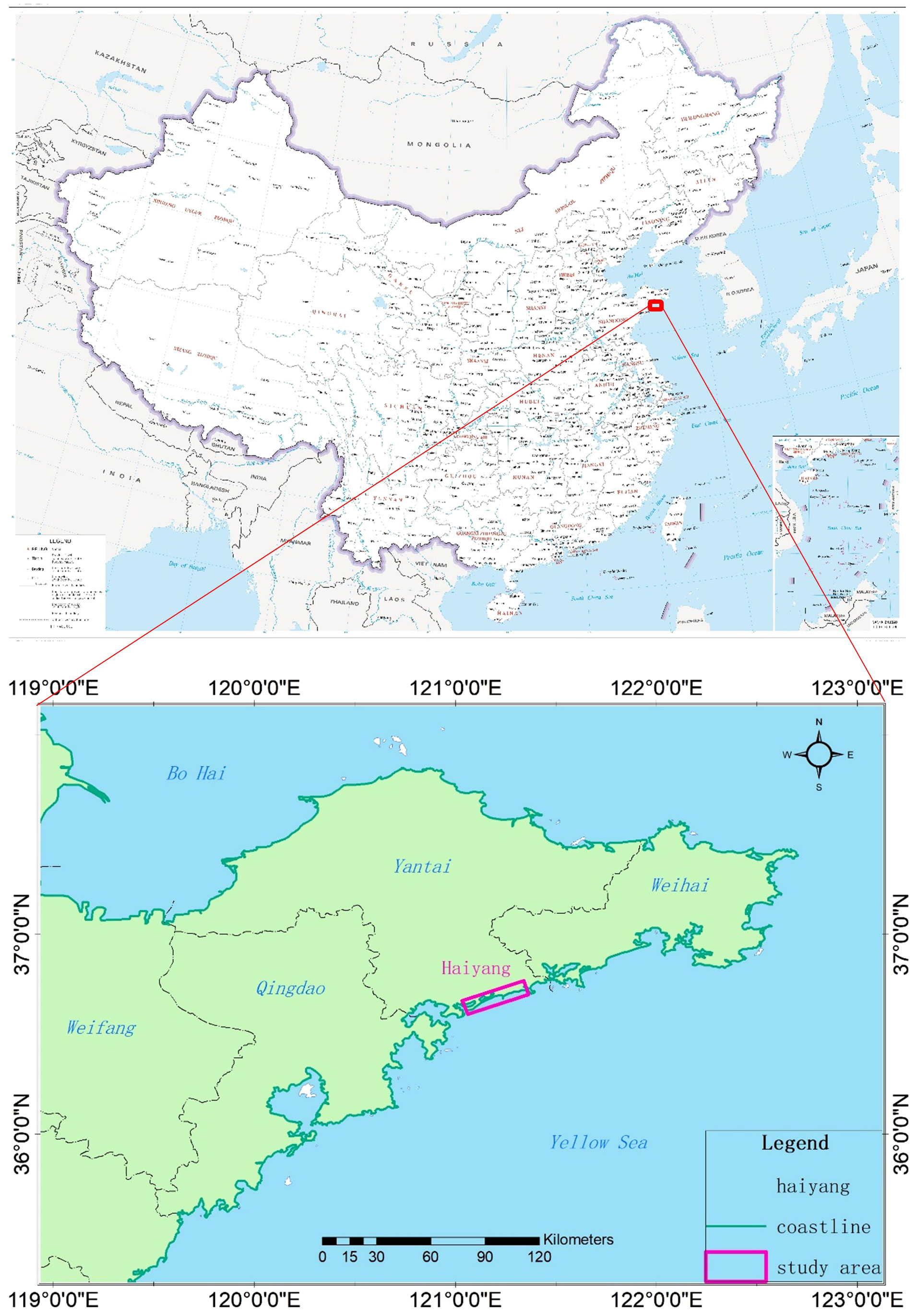
Figure 1 Study area.
The collection data includes remote sensing image data, GNSS RTK measurement point data, and LiDAR monitoring data, as shown in Table 1. Remote sensing data was downloaded from the 0.48m resolution remote sensing images of 91 Weitu (www.91weitu.com) in 2011, 2013, 2015, 2018, and 2021. GNSS data was sourced from annual profile monitoring from 2016 to 2018. LiDAR data was obtained from two repeated monitoring sessions in April and October 2018. GNSS measurement data is the profile analysis of coastal dune changes, while RS data analyzes typical characteristic lines of coastal dune changes by interpreting coastline, while LiDAR data is a full coverage surface analysis of the entire coastal dune change. By analyzing and evaluating the changing trends of coastal dunes separately, we aim to verify the monitoring results of the comprehensive technical method.
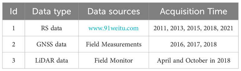
Table 1 The collection data.
2.2 RS data sources and coastline interpretation
The type of coastline in the research area belongs to sandy coastline. The interpretation method is determined according to the Technical Regulations for Coastal Zone Survey (908 Special Office of the State Oceanic Administration of China, 2005.). The sandy coastline is usually relatively straight, and the upper part of the beach is often piled up into a ridge-like sandy deposit parallel to the shore, called a beach ridge. The coastline is generally defined on the seaward side at the top of the beach ridge (Figure 2). For undeveloped or missing ridges, the coastline is generally defined on the seaward side of the line of significant changes in sandy vegetation growth. The landward side of the beach is a steep cliff and is directly connected, with the coastline defined at the intersection of the beach and the cliff (Figure 3). If the landward side of the beach is a seawall or road, the coastline can be defined as the foot of the seawall or road slope.

Figure 2 Schematic diagram of the general sandy coastline definition method.
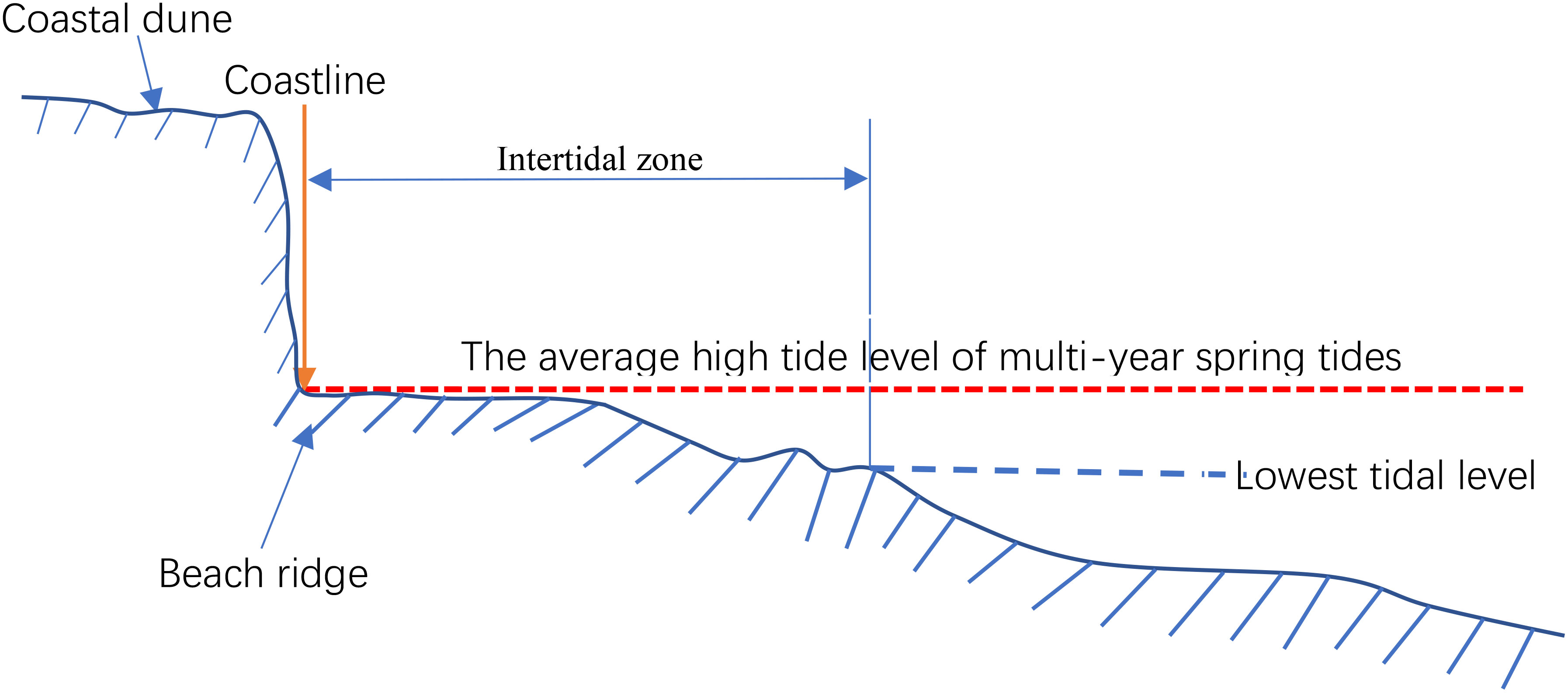
Figure 3 Schematic diagram of the method for defining sandy coastlines with steep cliffs.
2.3 GNSS-RTK profile measurements
Based on historical data and on-site surveys, typical monitoring sections are set up along the coastline, with vertical coastal trends and isobaths. The survey sections are appropriately densified near intensive aquaculture activities and important beach tourism areas on both sides of the Yangjiao River. The section layout is shown in Figure 4. The plans were continuously monitored once a year for three years from 2016 to 2018. GNSS-RTK equipment as adopted for coastal dune profile monitoring based on the Shandong CORS system, and the elevation datum was the CGCS2000 ellipsoidal height. The refined geoid of the Shandong continuous operating reference stations, (CORS) was converted to the 1985 national elevation datum of China. The starting point of each monitoring profile was located at the set marker post. Manual measurements were carried out during low tide, with a plane position better than 3 cm and a vertical direction better than 3 cm. Each measurement point did not deviate from the design measurement line by more than ± 10 cm.
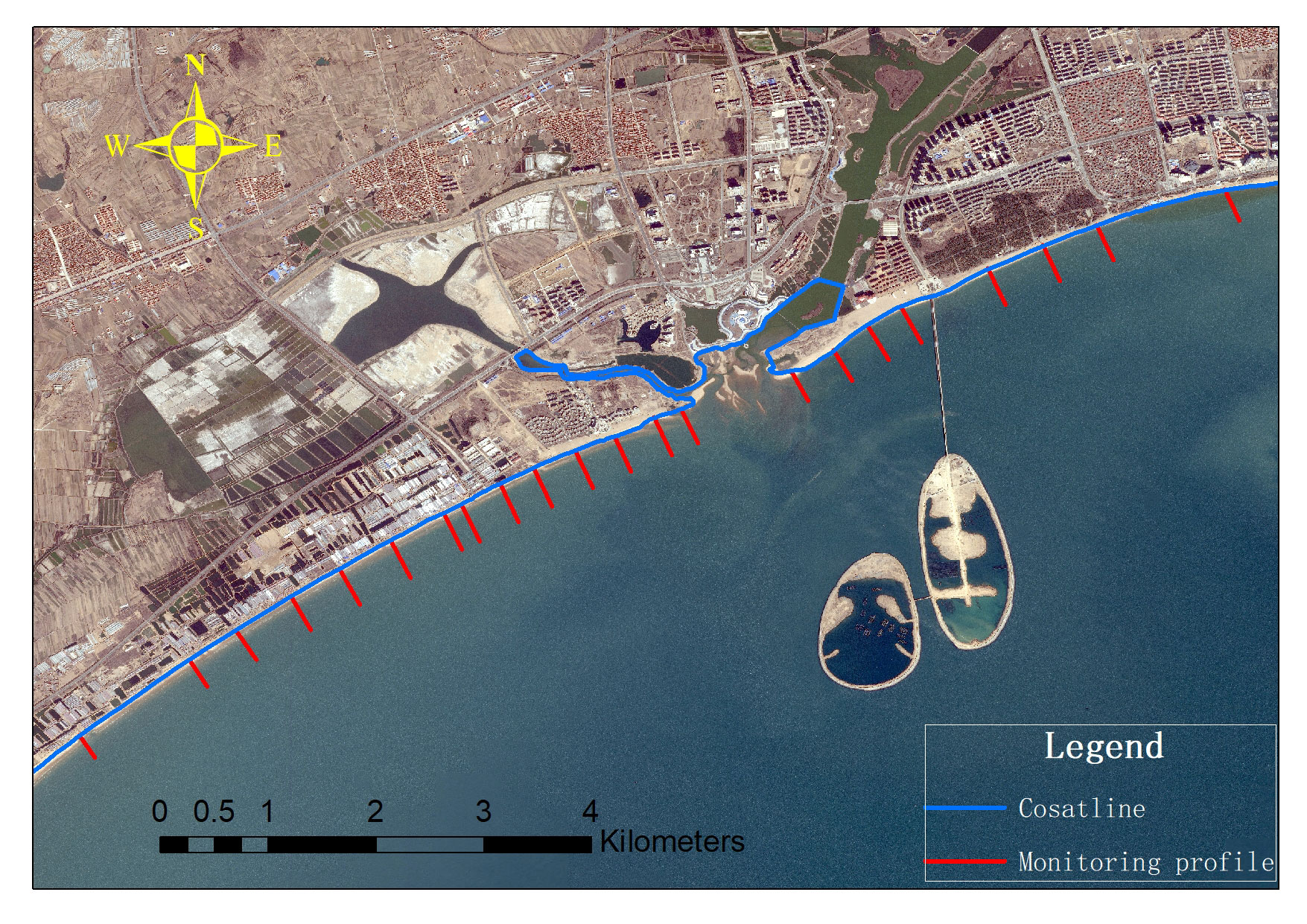
Figure 4 Layout of the coastal dune monitoring profile.
2.4 UAV LiDAR detection
Because the majority of the monitoring area was bare beach, there was no need to use laser scanner equipment with multiple echo functions. Therefore, the coastal dune monitoring system used the Spencer drone LiDAR system from Dihai Technology Co., Ltd. The system used the DJIM600 PRO as the unmanned aerial vehicle platform, integrating the Velodyne LiDAR VLP-16 laser scanner, which is lightweight, low-cost, and widely used in unmanned driving and measurement fields (Akhtar et al., 2019; Andrew et al., 2020; Gao et al., 2020; Jason et al., 2020), and the lightweight Trimble Applanix APX-15 positioning and attitude determination system (POS). The DJIM600 Pro is a six-rotor unmanned aerial vehicle with a payload of 6 kg and a flight time of approximately 15 minutes (fully loaded), supporting third-party software and hardware extensions. The UAV is equipped with a built-in minicomputer system to conduct hardware integration and data acquisition through the QinSy software on the computer system (Gao et al., 2020).
The measurement accuracy of the unmanned aerial vehicle LiDAR system was limited by the POS system configured by the drone. Due to cost and weight considerations, generally configured POS systems have lower accuracy than manned airborne lasers. To enhance accuracy, the flight altitude is usually reduced. To ensure that the laser point cloud data have a high density to meet the mapping needs, this flight was conducted at an altitude of 60 meters. Two survey lines were laid out on a sandy coast approximately 200 meters wide, with an overlap of approximately 30%. Each flight lasted for 10 minutes and covered approximately 1.5 km of coastal dunes. Two repeated monitoring periods were conducted in April and October 2018, respectively. Because the real-time positioning accuracy of drones cannot meet centimeter-level accuracy requirements, POS data need to be post-processed to obtain centimeter-level accuracy data. The monitoring and data processing process of the UAV LiDAR system is shown in Figure 5.
(1) Firstly, set up survey lines along the coastal dunes, with an overlap of about 30% between the lines, to ensure full coverage monitoring of the study area.
(2) When conducting UAV LiDAR monitoring, GNSS reference stations are set up in the measurement area. The flight path is determined through joint differential calculation of ground reference station GNSS data and unmanned aerial vehicle GNSS data. Coupled with POS data, the position and attitude information of the LiDAR at the surveying time are determined. Combined with parameters such as laser ranging and angle, the three-dimensional coordinates of each measurement point are obtained, and then geographic correction is performed to generate high-precision point cloud data.
(3) Strip splicing and deduplication. Splicing different strip point clouds to remove overlapping point clouds between strips, in order to avoid uneven distribution of point cloud data after stitching.
(4) Point cloud denoising. Based on the spatial distribution pattern of airborne LiDAR point cloud data, this paper adopts the SOR (statistical outlier removal) outlier denoising algorithm (Rusu et al., 2007) to filter out UAV LiDAR echo data that does not belong to reasonable observation values.
(5) Wave algorithm. On the basis of organizing discrete point cloud data of coastal dune monitoring areas using a regular grid, based on the principle of slope filtering algorithm, combined with the slope and elevation thresholds within the regular grid, an improved slope filtering method that is more suitable for coastal dune point cloud data is used for processing (Feng et al., 2023).
(6) DEM construction. Using point cloud data processed by denoising and filtering, a coastal dune area DEM is constructed using the inverse distance weight (IDW) interpolation method of a regular grid.
(7) Changes in coastal dune DEM. Based on generating two periods of DEM, using the difference operation of ArcGIS, obtain the coastal dune changes during the interval time between the two periods.
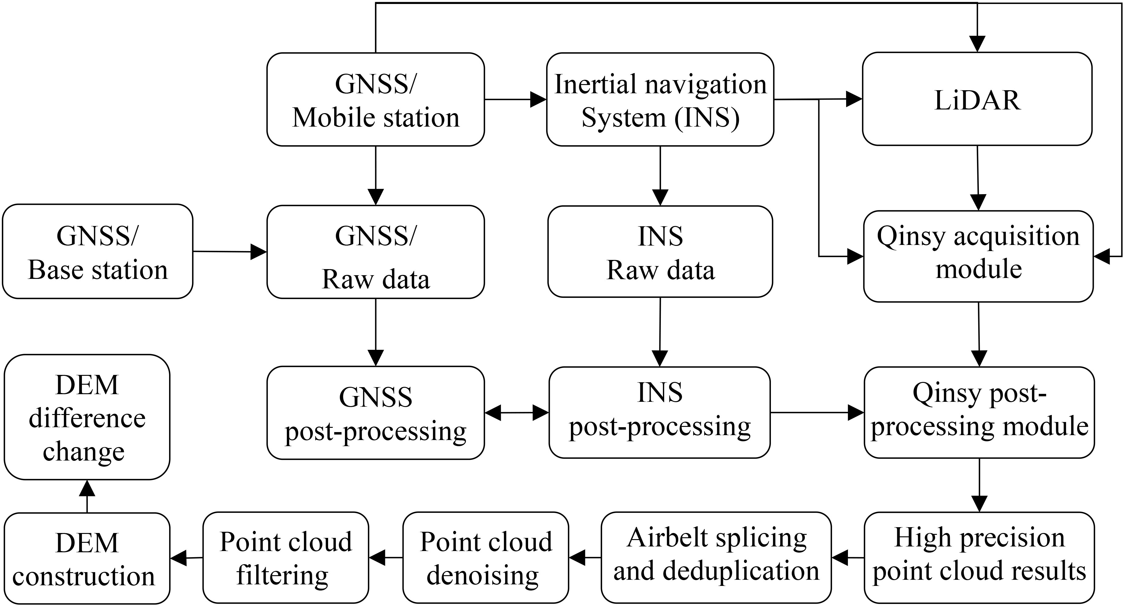
Figure 5 UAV LiDAR monitoring and data processing process.
3 Results and discussions
3.1 Coastline change based on RS
The accuracy of coastline extraction is the key to monitoring coastline changes. There are usually three methods for coastline extraction form remote sensing images: automatic extraction, semiautomatic extraction, and manual visual interpretation. The efficiency of automatic and semiautomatic extraction is much greater than that of manual visual interpretation. However, automatic and semiautomatic extraction of coastlines mostly involve instantaneous waterlines, which are significantly affected by periodic tides and are not suitable for analyzing spatiotemporal changes in coastlines (Zhang, 2021). Moreover, due to the difficulty in obtaining tide level and terrain data within the study area, it was also difficult to correct the obtained waterline position to the average high tide position. The artificial visual interpretation method is currently recognized as the method with the highest interpretation accuracy. This approach could overcome the above limitations by establishing strict interpretation standards and specifications and thus obtaining more accurate coastline positions.
Using the coastline interpretation method in Technical Regulations for Coastal Zone Survey (2005), five phases from 2011-2021 were extracted from Haiyang’s Ten Thousand Meters Beach, and the results are shown in Figures 6, 7. Figure 6 shows that, overall, during the 10-year period, the coastline did not change significantly and basically maintained a stable state. Only in the estuarine district did significant changes occur take place (Figure 7). The marked change in the coastline in the estuarine district was mainly due to artificial reclamation. In addition, the sand carried by the river into the sea caused minor changes in the coastline.
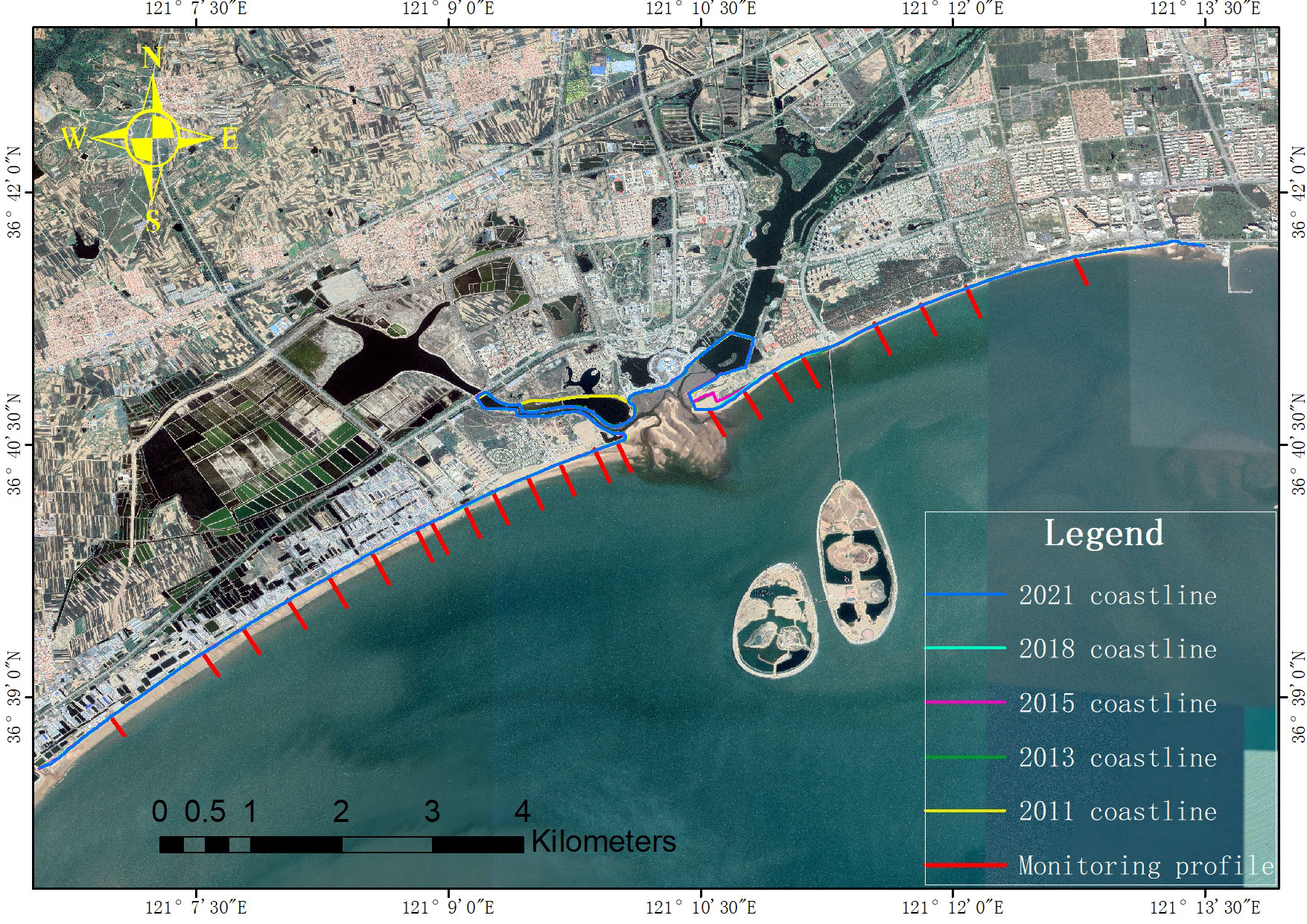
Figure 6 Changes in coastlines from 2011-2021.
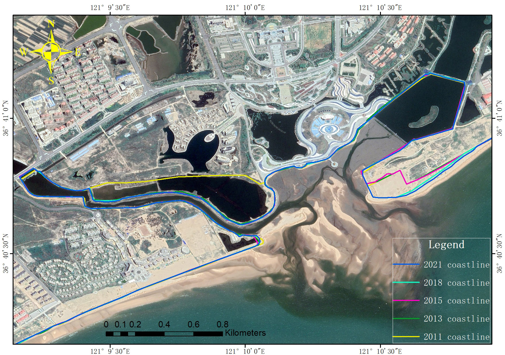
Figure 7 Changes in the coastline in the estuarine district from 2011-2021.
To further accurately quantify coastline changes, we calculated the rate of coastline change based on the baseline method. Five temporal coastlines were overlaid and buffered based on the 2011 coastline, using the buffer line above the coastline as the baseline. Then, a vertical line with a length D was drawn from the baseline to the coastlines of the other periods, and the distance d between the adjacent two vertical lines and the intersection point of the baseline was the baseline sampling interval. We set a sampling interval of 0.5 km, with each vertical line intersecting the coastline during the two periods. The ratio of the distance interval to the time interval between two coastlines was used as the endpoint rate of change (endpoint rate). The specific calculation method is shown in Formula 1:
In the equation, is the rate of change at the endpoint of the coastline between the m-th and n-th phases of the p-section. and represent the distances from the intersection point of two temporal coastlines on the p profile to the baseline. is the time interval between m and n.
The temporal and spatial patterns of the coastline change rate in Haiyang’s Ten Thousand Meters Beach coastal dunes from 2011 to 2021 are shown in Figure 8. A total of 337 profile lines were generated, during which 150 profile coastlines exhibited a positive change rate, with a maximum positive change rate of 33.75 m/a and an average positive change rate of 3.25 m/a. The change rate of 149 profile coastlines was negative, with a minimum negative change rate of -1.98 m/a and an average negative change rate of -0.28 m/a. The overall average rate of change was 1.32 m/a. According to the classification standards for coastal erosion in the Technical Regulations for Coastal Zone Survey (2005), 81% of the coastal sections in the study area are in a stable state; 6% of the bank sections are in a slightly eroded state, mainly distributed on both sides of the river mouth; 13% of the shore section is in a state of siltation, mainly concentrated in the estuary area. With the acceleration of urbanization, the construction land in the upper reaches of rivers has increased dramatically in the past decade. Effective soil and water conservation measures have led to a decrease in soil erosion, and the amount of soil carried by rivers into the sea has been decreasing year by year (Ma et al., 2018). Coastal sand dunes along the east and west sides of the estuary have not been able to replenish sufficient sediment transport, resulting in micro erosion on both sides of the estuary. Figure 8 shows that the area with the greatest change was still in the estuarine district, which was mainly caused by human cultivation and aquaculture. The coastal dunes of Haiyang beach maintain a relatively stable state overall, with some areas experiencing weak erosion.
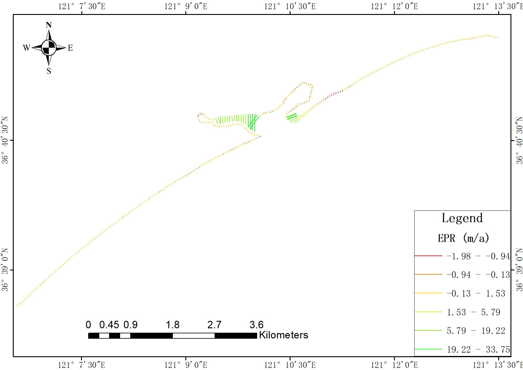
Figure 8 Temporal and spatial patterns of the coastline change rate (EPR) in coastal dunes from 2011-2021.
3.2 Typical profile changes in coastal dunes based on GNSS
According to the impacts of different human activities, the research area was divided into three regions: Block ① was the eastern section of Mahegang, Block ② was the western section of Yangjiaopan, and Block ③ was the eastern section of Yangjiaopan (Figure 9). Human activities had little impact on the eastern section of Mahe Port, which resemble the nature of coastal dunes. There were many farming activities in the western section of the Yangjiaopan sand dunes, and Lianli Island was constructed in the eastern section of Yangjiaopan.
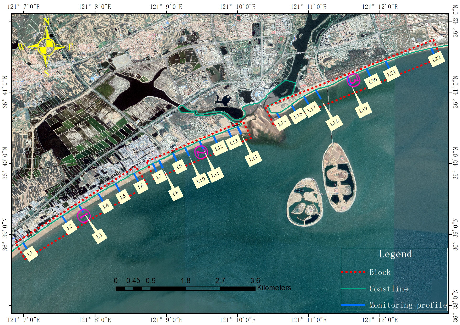
Figure 9 Coastal dune zoning.
In general, 68% of the profile foreshore in the 22 survey profiles was in an erosion state, 54% of the profile beach slope became steeper, 36% of the profile beach shoulder eroded or disappeared, the sand dune foreshore in the Hekou District where Yangjiaoban is located was slightly silted, the coastal dune foreshore extending to both sides of Yangjiaoban was in an erosion trend, and the sand dune foreshore far from the estuary and Lianli Island area was relatively stable. L represents the monitoring profile, and some typical profile elevation changes are shown in Figures 10–12.
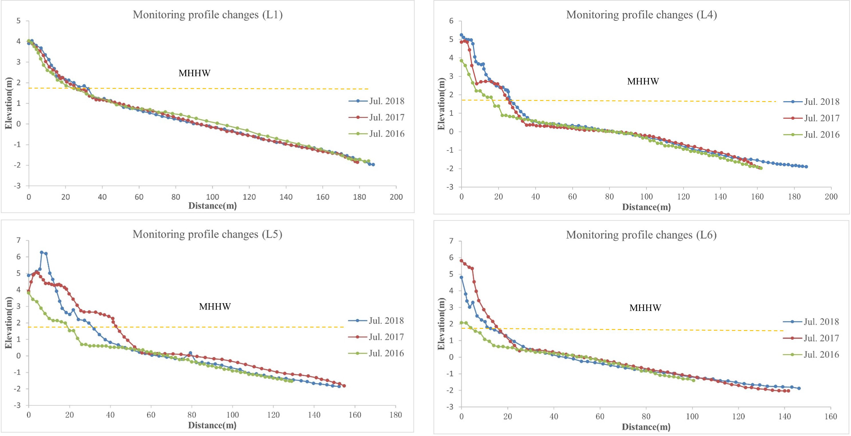
Figure 10 Typical sand dune profile changes in section ①.
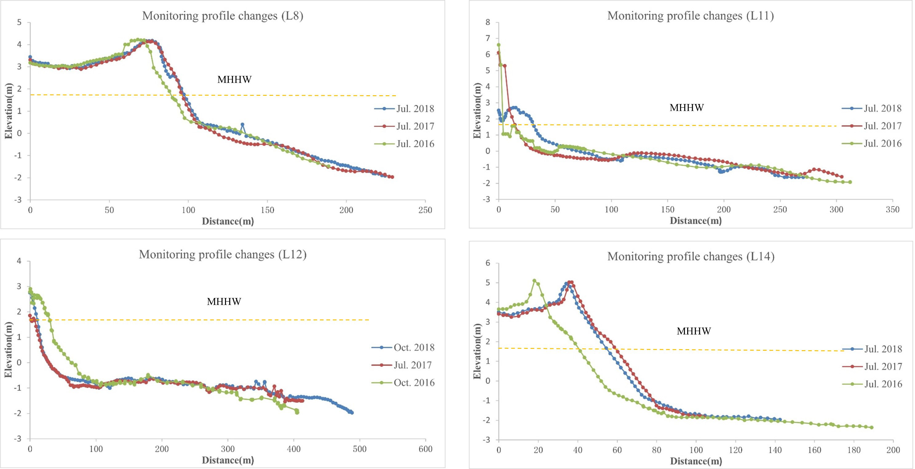
Figure 11 Typical sand dune profile changes in section ②.
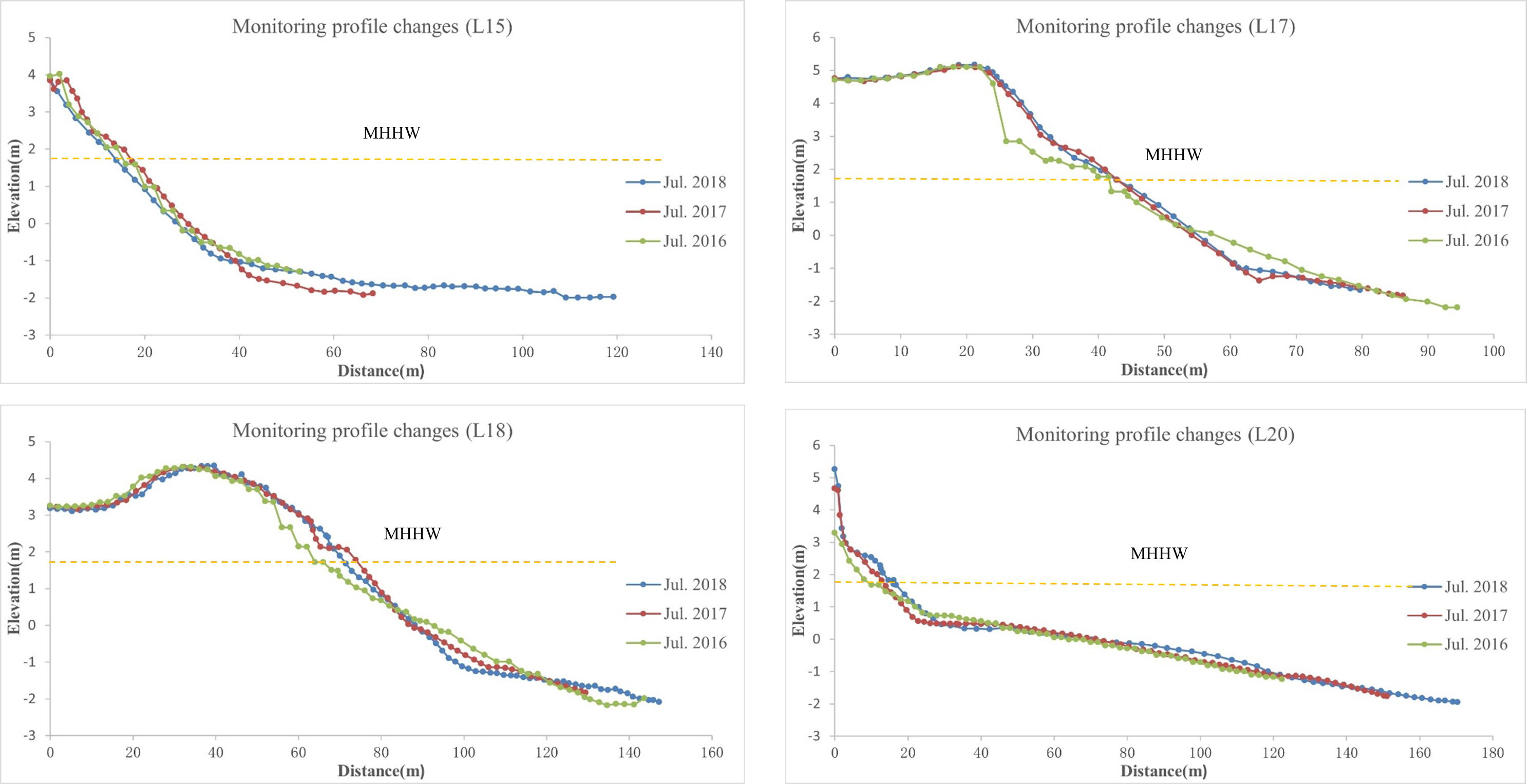
Figure 12 Typical sand dune profile changes in section ③.
(1) Coastal dunes (L1-L6) in the eastern section of Mahe Port in area ①.
The sand dunes above the eastern section of Mahe Port had slightly changed and been uplifted, mostly due to changes in coastal aquaculture activities and beach sand extraction. Except for the disappearance of the beach shoulder in the L1 profile, the beach shoulder in the other profiles was basically stable, and the foreshore remained relatively stable.
(2) Coastal dunes (L7-L14) in the western section of Yangjiaopan in area ②.
The backshore of the L7-L14 profile underwent significant erosion, while the foreshore underwent both coexistence of erosion and sedimentation. From west to east, there was a trend of erosion first, followed by sedimentation, mainly due to the proximity of the area to the river mouth, which brought a large amount of sediment into the sea, resulting in sedimentation.
(3) Coastal dunes (L7-L14) in the eastern section of Yangjiaopan in area ②.
The front shores of profiles L17-L21 showed an erosion trend, but the front shores of profiles L15 and L16, directly behind Lianli Island, showed sedimentation, with the characteristics and trend of island connected sandbars. This was due to the large amount of sediment carried into the sea by the estuary, while the front shore of profile L22 experienced sedimentation, which may be due to the blockage of seawater erosion by the construction of Haiyang Port. The back shore of the L15- L22 profile was both silted and eroded. Monitoring was conducted from July 2016 to 2018 during the peak tourist season with many tourists, so the back shore was strongly affected by tourists.
In summary, due to the significant impact of many tourist activities during the monitoring period, there were no obvious regular features on the backside of the sand dunes along the coast, while the foreshore was generally in a state of erosion.
3.3 Changes in coastal dune morphology based on LiDAR
In April 2018 and October 2018, unmanned aerial vehicle (UAV) radar monitoring was conducted on coastal dunes in the study area, and point cloud data from two phases of coastal dunes were obtained, as shown in Figure 13. Because the number of point clouds in LiDAR data typically reaches the order of millions, to improve the processing efficiency of computers while ensuring that the spatial point spacing of the point cloud is not too large due to sampling at a small analysis scale, resulting in a low number of neighboring points and reduced accuracy, the generated point cloud data were concatenated, filtered, and denoised with adjacent airstrips, and the entire denoised point cloud was used as the background for search thinning and complete point cloud classification. Then, a coastal dune surface TIN model was constructed using an irregular triangular network (Figure 14), and the DEM results of the monitoring shore section were obtained through the natural neighborhood interpolation method.
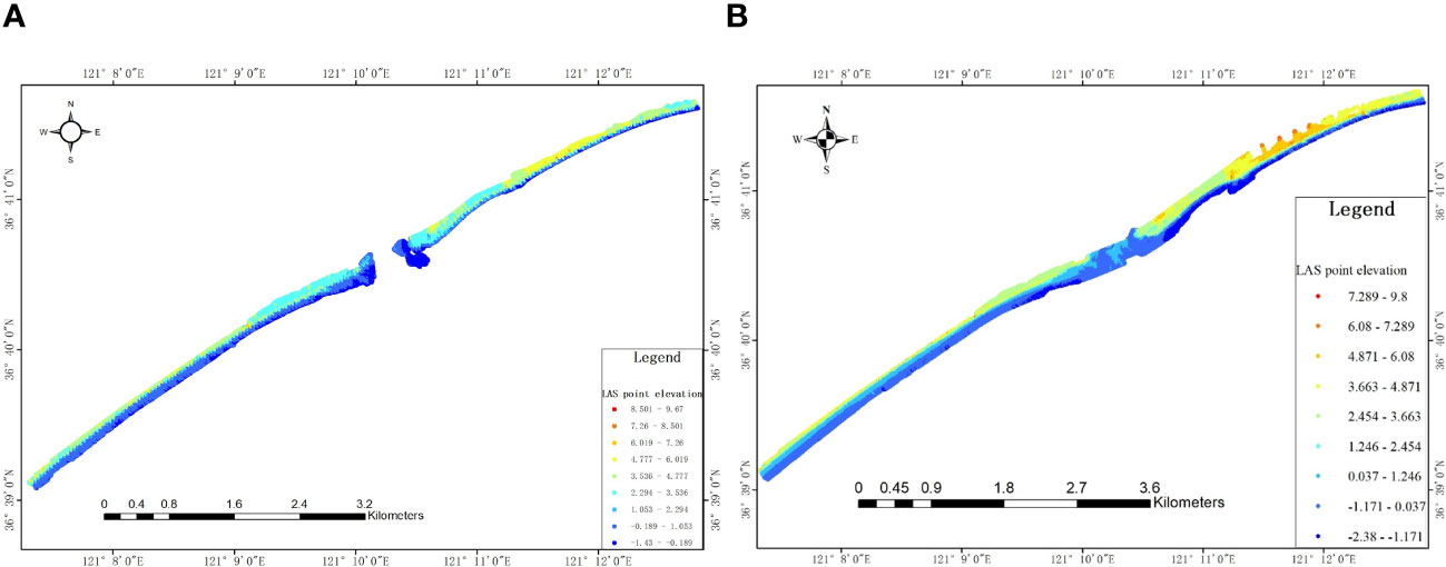
Figure 13 Results of the point cloud data for two monitoring periods of coastal dunes in April (A) and October (B), 2018.
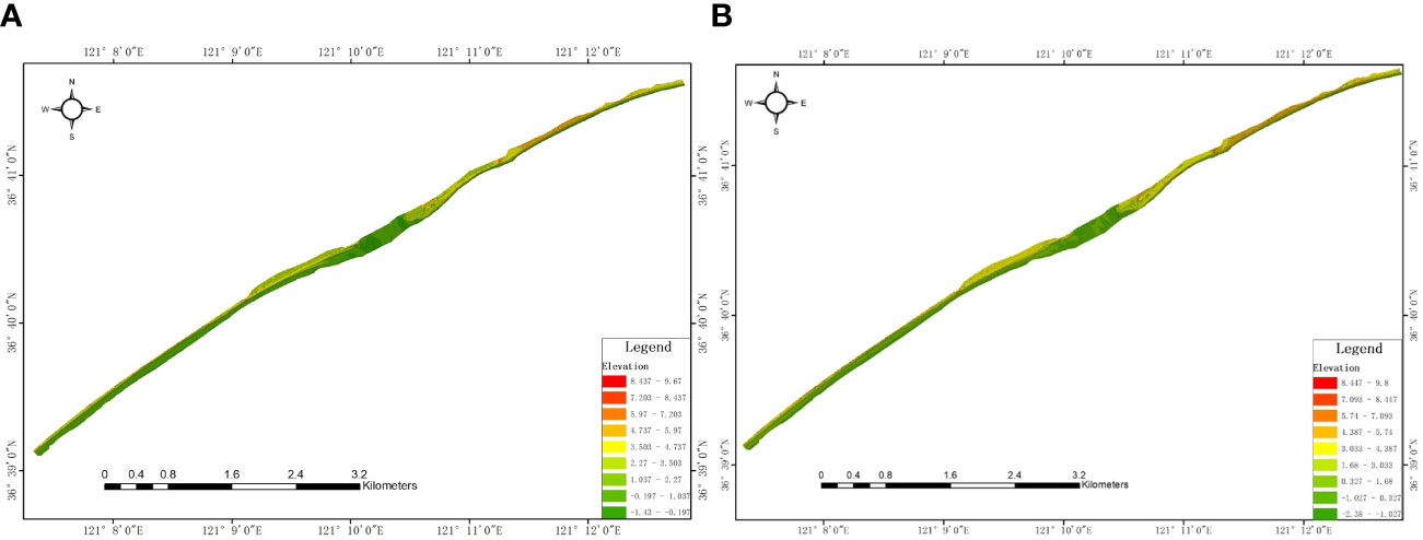
Figure 14 Two monitoring phases of TIN for coastal dune sections in April (A) and October (B), 2018.
3.3.1 UAV LiDAR monitoring accuracy evaluation
To ensure detection accuracy and verify whether the measurement accuracy of the UAV LiDAR system met monitoring needs, its accuracy was verified through sand dune terrain profiles. We measured cross-sections on the shore and compared the cross-sections extracted by DEM with the measured cross-sections. While the unmanned aerial vehicle LiDAR system collected terrain data for sandy coasts, the GNSS RTK was used to measure terrain profiles for vertical sandy coasts. The DEM generated from laser point cloud data was used to extract cross-sections, which were subsequently compared with the GNSS RTK measured points. The results are shown in Figure 15. Figure 15 shows that the extracted section data from the point clouds were in good agreement with the measured section point data, and the change trends were basically consistent. The average elevation difference between coastal dunes and beach profiles was 4 cm, and some jumping points exceeding 10 cm were due mainly to water accumulation on the beach, which affected the accuracy due to the inability of the lasers to penetrate the water. Furthermore, the humidity of the beach significantly impacted the accuracy. In addition, in the edge zone of the laser, the accuracy was relatively lower than that in the middle zone. However, overall, the accuracy of unmanned aerial vehicle LiDAR systems can meet the needs of monitoring dynamic changes in coastal dunes.
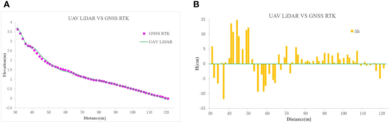
Figure 15 Comparison of GNSS RTK measured points and DEM profile elevation accuracy (A), and comparison of elevation changes (B).
3.3.2 Morphological changes in coastal dune areas
To obtain the changes in coastal dunes during the two monitoring periods, the DEMs from the two periods were unified in the same coordinate system and cropped to the same range (Figure 16). Then, the difference between the DEMs of the two periods was calculated to obtain the results of coastal dune changes, as shown in Figure 17. Figure 17 shows that the estuarine district ② had the largest area of change. The main reason was that there was ponding in the estuarine district during LiDAR monitoring in April 2018, and LiDAR point cloud data were not obtained in this area. When the area was interpolated into the TIN, the deviation was large, so there was a large difference when calculating the difference between the two DEMs. There was a slight erosion phenomenon at the front edge of the coastal dunes in Area ①, while there was slight uplift at the back of the sand dunes. Weak erosion also occurred at the front edge of the coastal dunes in Area ③, while the backside of the sand dunes remained basically unchanged. According to the rainfall monitoring results from nearby meteorological stations from April to August 2018, the climate was dry during this period, with less rainfall than usual, resulting in a significant reduction in the amount of sediment carried by the Liugezhuang River and Yangjiao Bank. This failure to timely supplement the coastal sand dunes with sediment transport from land rivers into the sea has disrupted the dynamic balance system between regional sediment transport and seawater erosion, providing a possibility for coastal erosion. The slight uplift phenomenon behind the sand dunes in Area ① may be caused by human activities in the aquaculture area or the behavior of tourists during the peak summer tourism season. Overall, the Haiyang coastal dune was relatively stable, with weak erosion on the front shore of the dune.
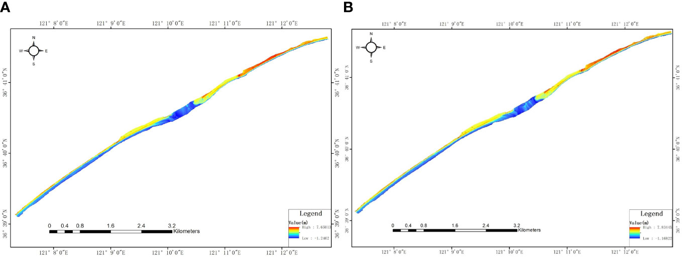
Figure 16 Two monitoring phases of the DEMs for coastal dune sections in April (A) and October (B), 2018.
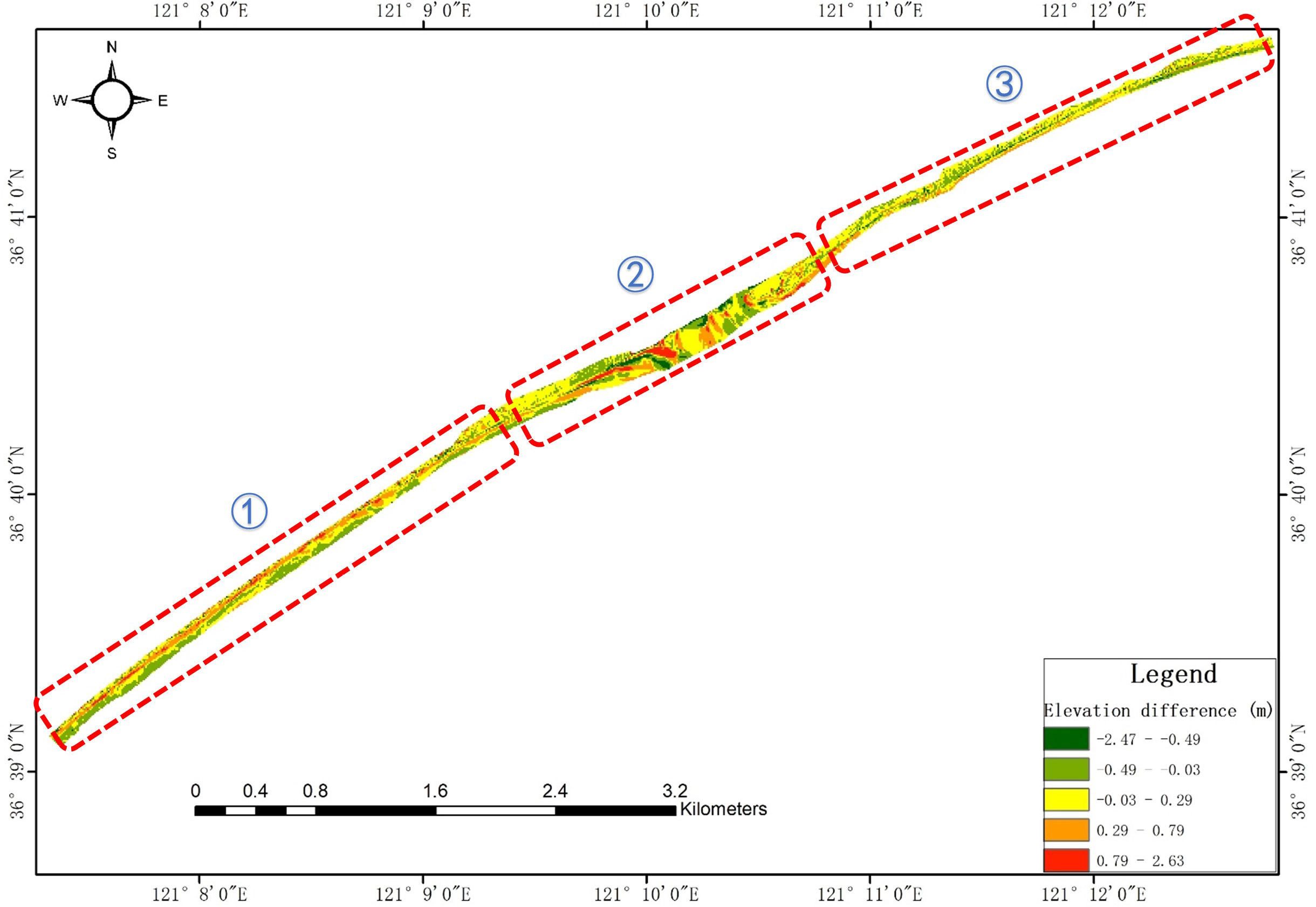
Figure 17 Difference in DEMs between the two monitoring periods of coastal dunes in 2018.
According to the 2022 China Sea Level Bulletin released by the Ministry of Natural Resources of China, from 1980 to 2022, the rate of sea level rise along the coast of China was 3.5mm/a. And the Shandong Peninsula has experienced in the process of slow crustal uplift at a rate of 1~4 mm/a (Zhang, 2004). Therefore, coastal erosion in this study area is less affected by sea level rise. The beach sediment in the research area comes from the sediment carried by the Liugezhuang River and the Yangjiaopan River into the sea. However, in the past 20 years, the amount of construction land in the region has increased dramatically, and the amount of soil entering the sea has decreased, which provides the possibility of coastal erosion (Ma et al., 2018). Haiyang’s Ten Thousand Meters dune terrain is open, the coastline is flat and straight, and the coastal trend is basically vertical to the normal wave direction. Most coastlines lack protection, and coasts are directly impacted by waves. After the waves break up in the nearshore surf zone, they will form strong scouring force, which provides dynamic conditions for coastal erosion.
According to the field investigation and analysis, the areas with large changes in coastal dunes were mostly distributed in areas with strong human disturbance, especially in areas where coastal aquaculture, artificial island and protruding dikes are located. Aquaculture along the west coast of Yangjiao Bank mostly occurred adjacent to the construction of sand dunes. Some aquaculture facilities occupy the back shore of sand dunes, and drainage pipes and culverts are exposed on the beach, directly damaging the beach profile shape and causing changes in the beach surface boundary and bottom friction, as well as changes in the beach’s ebb and flow patterns and coastal sediment transport. Moreover, some aquaculture farms use sand from coastal dunes for construction. After the construction of Lianli Island, most of the SSE waves and some of the SSW waves (Wang et al., 2021) were blocked, a wave shadow area was formed behind Lianli Island, and the waves diffract when passing through the island, breaking the dynamic equilibrium of the rear beach and leading to unbalanced sediment transport. In addition, multiple protruding embankments are distributed along the east coast of Haiyang Port, dividing the complete coastal dunes into multiple small sand dunes. The lengths of the protruding embankments are slightly longer than the length of the small beach, which not only breaks the original sediment transport pattern from west to east but also greatly changes the local water and sediment dynamic environment.
Open coastal sand dunes are prone to natural erosion and are a common erosion phenomenon in sandy coasts. However, the coastal sand dune changes that occurred at the Haiyang Ten Thousand Meters Beach not only disrupted the dynamic balance with seawater erosion due to the decrease in sediment transport from rivers entering the sea, but also resulted from unreasonable human activities that disrupted the beach profile and altered the regional water and sand dynamic environment, leading to coastal erosion.
4 Conclusion
(1) We comprehensively utilized LiDAR, GNSS, and RS technologies to detect changes in the coastal dunes of Haiyang and conducted a systematic and comprehensive analysis and evaluation of the morphological evolution of the dunes using three dimensions: point, line, and surface. Between 2016 and 2018, 68% of the foreshores of the 22 survey profiles of coastal dunes surveyed by GNSS points were in an eroded state. During 2011-2020, the coastline based on the RS data basically remained stable, only the estuarine district changed significantly, and the overall average change rate was 1.32 m/a. The overall morphological evolution of coastal dunes obtained by LiDAR in 2018 was relatively stable, but there was a weak erosion trend in the foreshore of the coastal dunes.
(2) This study used the UAV LiDAR system to carry out full-coverage monitoring of coastal dunes, quickly obtained high-precision laser point cloud data, generated DEMs, and conducted accuracy testing, allowing the monitoring results to be more intuitive. The ability to meet the needs of coastal dune migration monitoring has created an effective and rapid technical process for obtaining and producing DEM data. This is a successful attempt to apply UAV LiDAR technology in the marine industry, enriching the technical system for monitoring the evolution of coastal dune morphology, and providing a practical path for promoting UAV LiDAR in island and coastal zone monitoring. With the low cost of UAV platforms and the continuous maturity and lightweight design of LiDAR, this technology has enormous development prospects and application use.
(3) The major reasons for the changes in coastal dunes are the changes in coastal dynamic processes and coastal sediment transport caused by human activities in the Haiyang coastal dune area. The research results can provide precise guidance for remediating and restoring eroded beaches. It is also recommended to gradually dismantle the aquaculture near the west coast of Yangjiao Bank and multiple protruding embankments on the west side of the Haiyang Nuclear Power Plant, and implement beach feeding on coastal dunes.
Data availability statement
The original contributions presented in the study are included in the article/supplementary material. Further inquiries can be directed to the corresponding author.
Author contributions
DM: Conceptualization, Data curation, Formal analysis, Funding acquisition, Methodology, Software, Validation, Visualization, Writing – original draft, Writing – review & editing. ZT: Conceptualization, Data curation, Investigation, Methodology, Project administration, Software, Supervision, Writing – review & editing. CZ: Data curation, Formal analysis, Software, Writing – review & editing. YW: Formal analysis, Investigation, Writing – review & editing.
Funding
The author(s) declare financial support was received for the research, authorship, and/or publication of this article. This research was funded by Shandong Provincial Natural Science Foundation (No. ZR2023MD080, ZR2022QD002), Fujian Key Laboratory of Island Monitoring and Ecological Development (Island Research Center, MNR) (No. 2023ZD08), the National Natural Science Foundation of China (No. 42207173), the Public Science and Technology Research Funds Projects of Ocean (No. 201405028), and the Marine Industry Standards (No. 201810011-T).
Conflict of interest
The authors declare that the research was conducted in the absence of any commercial or financial relationships that could be construed as a potential conflict of interest.
Publisher’s note
All claims expressed in this article are solely those of the authors and do not necessarily represent those of their affiliated organizations, or those of the publisher, the editors and the reviewers. Any product that may be evaluated in this article, or claim that may be made by its manufacturer, is not guaranteed or endorsed by the publisher.
References
908 Special Office of the State Oceanic Administration of China (2005). Technical Regulations for Coastal Zone Survey (Beijing: China: Ocean Press).
Akhtar M. R., Qin H. B., Chen G. C. (2019). “Velodyne LiDAR and monocular camera data fusion for depth map and 3D reconstruction,” in Proceedings of Eleventh International Conference on Digital Image Processing(ICDIP 2019), Chengdu, China.
Andrew L. H., Travis W., Benjamin W., Amr A. (2020). Scan pattern characterization of Velodyne VLP-16 Lidar sensor for UAS laser scanning. Sensors 20 (24), 7351. doi: 10.3390/s20247351
Bailey S. D., Bristow C. S. (2004). Migration of parabolic dunes at Aberffraw, Anglesey, north Wales. Geomorphology 59 (1-4), 165–174. doi: 10.1016/j.geomorph.2003.09.013
Banerjee D., Hildebrand A. N., Murraywallace C. V., Bourman R. P., Brooke B. P., Blair M. (2003). New quartz SAR-OSL ages from the stranded beach dune sequence in south-east South Australia. Quaternary Sci. Rev. 22 (10), 1019–1025. doi: 10.1016/S0277-3791(03)00013-1
Bañón L., Pagán J. I., López I., Banon C., Aragonés L. (2019). Validating UAS-based photogrammetry with traditional topographic methods for surveying dune ecosystems in the Spanish mediterranean coast. J. Mar. Sci. Eng. 7, 297. doi: 10.3390/jmse7090297
Brodie K., Conery I., Cohn N., Spore N., Palmsten M. (2019). Spatial variability of coastal foredune evolution, part A: timescales of months to years. J. Mar. Sci. Eng. 7 (5), 124. doi: 10.3390/jmse7050124
Claudino-Sales V., Wang P., Horwitz M. H. (2007). Factors controlling the survival of coastal dunes during multiple hurricane impacts in 2004 and 2005: Santa Rosa barrier island, Florida. Geomorphology 95 (3-4), 295–315. doi: 10.1016/j.geomorph.2007.06.004
Crapoulet A., Héquette A., Levoy F., Bretel P. (2016). Using liDAR topographic data for identifying coastal areas of northern France vulnerable to sea-level rise. J. Coast. Res. 75 (sp1), 1067–1071. doi: 10.2112/SI75-214.1
Delgado-Fernandez I., Davidson-Arnottt R., Ollerhead J. (2009). Application of a remote sensing technique to the study of coastal dunes. J. Coast. Res. 25 (5), 1160–1167. doi: 10.2112/09-1182.1
Dong Y. X. (2006). The coastal aeolian geomorphic types and their distribution pattern in China. Mar. Geol. Quaternary Geol. 26 (4), 99–104. doi: 10.16562/j.cnki.0256-1492.2006.04.014
Dong Y. X., Huang D. Q. (2014). Typical research on the movement and topographic change of coastal crescent dune. Scientia Geographica Sin. 34 (7), 863–869. doi: 10.13249/j.cnki.sgs.2014.07.004
Dong Y. X., Li Z. Z. (2022). Review of coastal aeolian geomorphology research in China in the past 40 years. J. Desert Res. 42 (1), 12–22. doi: 10.7522/j.issn.1000-694X.2021.00182
Dong Z. B., Lv P. (2020). Development of aeolian geomorphology in China in the past 70 years. Acta Geographica Sin. 75 (3), 509–528. doi: 10.11821/dlxb202003006
Dong Y. X., Zhang Q. N., Huang D. Q. (2019). Progress and prospect of research on coastal wind-eroded landform. Adv. Earth Sci. 34 (1), 1–10. doi: 10.11867/j.issn.1001-8166.2019.01.0001
Elbelrhiti H., Claudin P., Andreotti B. (2005). Field evidence for surface-wave-induced instability of sand dunes. Nature 437 (7059), 720–723. doi: 10.1038/nature04058
Feng X. K., Lv P. X., Zhang K., Shen H. K., Ye L. J., Zhao N., et al. (2023). The filtering method of airborne LiDAR point cloud for tidal flat DEM construction. Bull. Survey. Mapp. 7, 58–62. doi: 10.13474/j.cnki.11-2246.2023.0201
Gao X. G., Tian Z. W., Ma D. M., Liu Y. X., Xu W. X. (2020). Application of UAV LiDAR system in sandy coast monitoring. Mar. Environ. Sci. 39 (3), 468–472. doi: 10.13634/j.cnki.mes.2020.03.022
Garrido M. S., Giménez E., Ramos M. I., Gil A. J. (2013). A high spatio-temporal methodology for monitoring dunes morphology based on precise GPS-NRTK profiles: Test-case of Dune of Monsul on the south-east Spanish coastline. Aeolian Res. 8, 75–84. doi: 10.1016/j.aeolia.2012.10.011
Gay S. P. (1999). Observations regarding the movement of barchan sand dunes in the Nazca to Tanaca area of southern Peru. Geomorphology 27 (3-4), 279–293. doi: 10.1016/S0169-555X(98)00084-1
Guillot B., Pouget F. (2015). UAV application in coastal environment, example of the Oleron island for dunes and dikes survey. Int. Arch. Photogram. Remote Sens. Spatial Inf. Sci, 40-3, 321–326. doi: 10.5194/isprsarchives-XL-3-W3-321-2015
Harley M. D., Turner I. L., Short A. D., Ranasinghe R. (2006). Assessment and integration of conventional, RTK-GPS and image-derived beach survey methods for daily to decadal coastal monitoring. Coast. Eng. 58, 194–205. doi: 10.1016/j.coastaleng.2010.09.006
Havivi S., Amir D., Schvartzman I., August Y., Maman S., Rotman S. R., et al. (2018). Mapping dune dynamics by InSAR coherence. Earth Surface Processes Landforms 43, 1229–1240. doi: 10.1002/esp.4309
Hesp P., Castilhos J. A. D., Silva G. M. D., Dillenburg S., Martinho C. T., Aguiar D., et al. (2007). Regional wind fields and dune field migration, southern Brazil. Earth Surface Processes Landforms 32 (4), 561–573. doi: 10.1002/esp.1406
Jason B., Henri M. D., Greoire M. (2020). Dense point cloud acquisition with a low-cost Velodyne VLP-16. Geosci. Instrument. Methods Data System 9 (2), 385–396. doi: 10.5194/gi-9-385-2020
Keun C. S., Hyeok K. G., Wan C. J., Li L. S., Yoen C. D., Heuk J. S., et al. (2017). UAV-based land cover mapping technique for monitoring coastal sand dunes. J. Korean Soc. Survey. Geodesy Photogram. Cartography 35, 11–22. doi: 10.7848/ksgpc.2017.35.1.11
Kilibarda Z., Shillinglaw C. (2015). A 70 year history of coastal dune migration and beach erosion along the southern shore of lake Michigan. Aeolian Res. 17, 263–273. doi: 10.1016/j.aeolia.2014.09.002
Koprowski M., Winchester V., Zielski A. (2010). Tree reactions and dune movements: Slowinski National Park, Poland. Catena 81 (1), 55–65. doi: 10.1016/j.catena.2010.01.004
Łabuz T. A. (2016). A review of field methods to survey coastal dunes-experience based on research from South Baltic coast. J. Coast. Conserv. 20, 175–190. doi: 10.1007/s11852-016-0428-x
Łabuz T. A., Grunewald R., Bobykina V., Chubarenko B., Česnulevičius A., Bautrenas A., et al. (2018). Coastal dunes of the Baltic Sea shores: A review. Quaestiones Geographicae 37 (1), 47–71. doi: 10.2478/quageo-2018-0005
Levin N. (2011). Climate-driven changes in tropical cyclone intensity shape dune activity on Earth’s largest sand island. Geomorphology 125 (1), 239–252. doi: 10.1016/j.geomorph.2010.09.021
Levin N., Jablon P. E., Phinn S., Collins K. (2017). Coastal dune activity and foredune formation on Moreton Island, Australia 1944-2015. Aeolian Res. 25, 107–121. doi: 10.1016/j.aeolia.2017.03.005
Li Z. X., Li Z. Z., Jin J. H., Zheng F., Zhang W. J., Bai L. (2020). Spatial-temporal variation of drift potential and dune morphology evolution during 2008-2018 in Changli coast of Hebei, China. J. Desert Res. 40 (3), 94–105. doi: 10.7522/j.issn.1000-694X.2019.00074
Liu G. J., Gao W. M., Li J. (2010). Research on GPS RTK technology to monitor the dynamic coastal dunes. Hydrographic Survey Charting 30 (1), 56–58.
Ma D. M., Liu Y. X., Li Z. H., Bao H. W., Jin Z. G. (2021). Recognition of the coastal dune migration micro-deformation in Changli gold coast of China based on GB-InSAR. Mar. Georesources Geotechnol. 39 (6), 747–755. doi: 10.1080/1064119X.2020.1755917
Ma D. M., Wang Y. Z., Zhao M., Tian Z. W. (2018). Estimation and evolution of soil erosion in river basin around Haiyang Ten Thousand Meters Beach. Period. Ocean Univ. China 48 (SupII), 88–97. doi: 10.16441/j.cnki.hdxb.20180133
Madsen A. T., Murray A. S. (2013). Optically stimulated luminescence dating of young sediments: A review. Geomorphology 109 (1), 3–16. doi: 10.1016/j.geomorph.2008.08.020
Marin L., Forman S. L., Valdez A., Bunch F. (2005). Twentieth century dune migration at the great sand dunes national park and preserve, Colorado, relation to drought variability. Geomorphology 70 (1-2), 163–183. doi: 10.1016/j.geomorph.2005.04.014
Martínez M. L., Landgrave R., Silva R., Hesp P. (2019). Shoreline dynamics and coastal dune stabilization in response to changes in infrastructure and climate. J. Coast. Res. 35, 6–12. doi: 10.2112/SI92-002.1
Mountney N. P., Russell A. J. (2006). Coastal aeolian dune development, Sólheimasandur, southern Iceland. Sediment. Geol. 192 (3-4), 167–181. doi: 10.1016/j.sedgeo.2006.04.004
Nagihara S., Mulligan K. R., Xiong W. (2004). Use of a three-dimensional laser scanner to digitally capture the topography of sand dunes in high spatial resolution. Earth Surface Processes Landforms 29 (3), 391–398. doi: 10.1002/esp.1026
Palalane J., Larson M. (2020). A long-term coastal evolution model with longshore and cross-shore transport. J. Coast. Res. 36 (2), 411–423. doi: 10.2112/JCOASTRES-D-17-00020.1
Porat N., Botha G. A. (2008). The luminescence chronology of dune development on the Maputaland coastal plain, southeast Africa. Quaternary Sci. Rev. 27 (9-10), 1024–1046. doi: 10.1016/j.quascirev.2008.01.017
Pozzebon A., Bove C., Cappelli I., Alquini F., Bertoni D., Sarti G. (2016). Heterogeneous wireless sensor network for real time remote monitoring of sand dynamics on coastal dunes. World Multidiscip. Earth Sci. Symposium(WMESS 2016) PTS 1-4, 44. doi: 10.1088/1755-1315/44/4/042030
Putri R. F., Wibirama S., Sukamdi S., Giarsih S. R. (2017). Sand dune conservation assessment in coastal area using alos palsar DInSAR technique. J. Urban Environ. Eng. 11 (1), 9–29. doi: 10.4090/juee.2017.v11n1.9-29
Rebêlo L. P., Brito P. O., Monteiro J. H. (2002). Monitoring the Cresmina dune evolution (Portugal) using differential GPS. J. Coast. Res. 36, 591–604. doi: 10.2112/1551-5036-36.sp1.591
Rhew H. S., Yu K. B. (2009). Pattern of aeolian sand transport and morphological change in the foredune ridge, Shindu dune field, Korea: a case study during the winter, December 2000 to March 200. J. Coast. Res. 25 (4), 1015–1024. doi: 10.2112/06-0674.1
Rusu R. B., Blodow N., Marton Z., Soos A., Beetz M. (2007). “Towards 3D object maps for autonomous household robots. Intelligent Robots and Systems,” in 2007 IEEE/RSJ International Conference on; San Diego, CA, USA.
Schmelz W. J., Psuty N. P. (2019). Quantification of airborne lidar accuracy in coastal dunes (Fire island, New York). Photogram. Eng. Remote Sens. 85 (2), 133–144. doi: 10.14358/PERS.85.2.133
Taddia Y., Corbau C., Zambello E., Pellegrinelli A. (2019). UAVs for structure-from-motion coastal monitoring: a case study to assess the evolution of Embryo dunes over a two-year time frame in the Po river delta, Italy. Sensors 19, 1717. doi: 10.3390/s19071717
Thornton E. B., Sallenger A., Sesto J. C., Egley L., McGee T., Parsons R. (2006). Sand mining impacts on long-term dune erosion in southern Monterey Bay. Mar. Geol. 229 (1-2), 45–58. doi: 10.1016/j.margeo.2006.02.005
Tsoar H., Blumberg D. G. (2002). Formation of parabolic dunes from barchan and transverse dunes along Israel’s Mediterranean coast. Earth Surface Processes Landforms 27 (11), 1147–1161. doi: 10.1002/esp.417
Vespremeanu-Stroe A., Preoteasa L. (2007). Beach-dune interactions on the dry-temperate Danube delta coast. Geomorphology 86 (3-4), 267–282. doi: 10.1016/j.geomorph.2006.09.011
Vliet-Lanoë B. V., Goslin J., Hénaff A., Hallégouët, B., Delacourt C., Cornec E. L., et al. (2016). Holocene formation and evolution of coastal dunes ridges, Brittany (France). Comptes Rendus Geosci. 348 (6), 462–470. doi: 10.1016/j.crte.2015.01.001
Wang Y. Z., Tian Z. W., Li X., Sun H. F. (2021). Coastal erosion mechanism and its prevention in Haiyang. Mar. Sci. 45 (12), 18–30. doi: 10.11759/kykx20210202001
Xia J., Dong P. (2016). A GIS add-in for automated measurement of sand dune migration using LiDAR-derived multitemporal and high-resolution digital elevation models. Geosphere 12 (4), 1316–1322. doi: 10.1130/GES01329.1
Yue N. N. (2008). Impact studies of the man-made island project to the vicinity of area on the sandy coast (Qingdao: Ocean University of China).
Zhang X. L. (2004). Marine disasters and their reduction in Shandong Province. Mar. Sci. Bull. 23 (3), 66–72.
Zhang Y. X. (2021). Research on spatial and temporal characteristics of island coastline along the maritime Silk Road (Yantai: Yantai Institute of Coastal Zone Research, Chinese Academy of Sciences).
Zhao L. (2017). Research on the dynamic evolution trend of coastal dunes in Changli, Hebei (Shijiazhuang: Hebei Normal University).
Keywords: coastal dunes, LiDAR, GNSS, RS, dynamic changes
Citation: Ma D, Tian Z, Zhu C and Wang Y (2024) A comprehensive approach to evaluate coastal dune evolution in Haiyang, China. Front. Mar. Sci. 11:1326317. doi: 10.3389/fmars.2024.1326317
Received: 23 October 2023; Accepted: 17 January 2024;
Published: 06 February 2024.
Edited by:
Inmaculada Rodríguez-Santalla, Rey Juan Carlos University, SpainReviewed by:
Shanwei Liu, China University of Petroleum (East China), ChinaJianjun Jia, East China Normal University, China
Copyright © 2024 Ma, Tian, Zhu and Wang. This is an open-access article distributed under the terms of the Creative Commons Attribution License (CC BY). The use, distribution or reproduction in other forums is permitted, provided the original author(s) and the copyright owner(s) are credited and that the original publication in this journal is cited, in accordance with accepted academic practice. No use, distribution or reproduction is permitted which does not comply with these terms.
*Correspondence: Ziwen Tian, dGVzZXdlbkBmaW8ub3JnLmNu