Abstract
This paper critically examines the intersections of Science, colonialism, and cartography in shaping perceptions of the ocean and its human-nature relationships. Drawing on Postcolonial Science and Technology Studies (PCSTS) and Decolonial Theory, it scrutinizes historical mapping practices, revealing how they perpetuated ontological hierarchies and controlled narratives of the ocean. Through archival research spanning from the Revolution to colonial exploration, the paper exposes how maps framed the ocean as a controllable entity, obscuring socio-cultural dimensions of biodiversity. Focusing on a case study in Northern Kwazulu-Natal, South Africa, the authors explore an Empatheatre mapping process, that challenges Western ontologies and promotes counter-hegemonic cartographic practices. Situating this within critical cartography and PCSTS literature, the paper reveals how colonial projects molded perceptions of oceanic space and influenced environmental governance. In the South African context, the ocean is haunted by a violent history of racial exclusion and ecological exploitation. Initiatives like Operation Phakisa’s Blue Economy plan underscore the tension between economic growth and ecological sustainability, leading to rapid coastal developments. Marine Spatial Planning (MSP) emerges as a tool to reconcile these interests, yet its implementation raises questions about inclusivity and community participation. Introducing the Empatheatre method, characterized by a ‘Call and Response’ approach, the paper invites local communities to co-create maps reflecting their concerns and relationships with the ocean. Through attentive listening and collaborative storytelling, Empatheatre challenges traditional consultation methods, prioritizing meaningful engagement and collective meaning-making. Mapping in this context is not merely a static representation but a dynamic process of collective thinking and relationality. By foregrounding the social, cultural, and ecological context, Empatheatre’s approach redefines the mapmaker-map relationship and empowers communities as active agents in shaping their narratives. The transformative potential of Empatheatre lies in its ability to shift power dynamics and foster empathy between diverse stakeholders. Through performative storytelling and visual representations, Empatheatre creates space for marginalized voices and alternative modes of knowledge transmission. In conclusion, this paper advocates for a decolonial approach to oceanic cartographies that acknowledges diverse ontologies and fosters inclusive governance structures.
Introduction
This paper emerges from a recognition of the ways in which the power-laden projects of Science, colonialism, and cartography have produced and entrenched a particular way of seeing the world and the human-nature relationships that constitute it (Harley, 1988; Edney, 1997; Steinberg, 2001; Garuba, 2002). We revisit the ocean archived in colonial maps to understand what and who laid the foundations for claiming and representing oceanic relationalities and ask what ontological residues remain from the entwinement of Science, colonialism, and cartography? We ask this before skipping both forwards and backwards in time to dream new cartographic imaginaries in order to develop new ways of seeing and representing the relations between humans and the ocean. We present archival research on the practices and products of mapping the ocean during the European Scientific Revolution (16th – 18th centuries) and the colonial exploration and exploitation of the ocean that followed. We outline how scientific, colonial mapping practices tamed a wild and mythic ocean to gain control, separated humans from nature, and engendered an ontological hierarchy. From this flowers a deep reflection on an Empatheatre mapping process that took place in Northern Kwazulu-Natal, South Africa in October 2021. This careful process transforms normative mapping relations and steps out from the confines of Western ontologies. This process suggests that it is possible to craft future approaches to mapping that do not replicate or reinscribe colonial dynamics.
The paper begins by formulating the theoretical lens through which Science, maps, and colonisation will be analysed. This is done by engaging with literature from Postcolonial Science and Technology Studies (PCSTS) and Decolonial Theory (Fanon, 1965; Brockway, 1979; Escobar, 1998, 2018; Wynter, 2006; Harding, 2008; Seth, 2009; Adams and Mulligan, 2012; De Sousa Santos, 2015; George and Wiebe, 2020; Quintero-Weir et al., 2023). This is followed by an engagement with the legacies of scientific mapping of ocean space and the traces left behind in marine biodiversity governance. We identify; (1) how maps facilitate the production of manageable land and seascapes through which people, nature, and their relations can be controlled, (2) how science and mapping separates humans from nature, prioritising biological elements of the natural environment and erasing the socio-cultural natures of biodiversity custodianship, and (3) how maps, through their claim (active or passive) to objectivity, enshrine an ontological superiority. From this unveiling of power, separation, and ontological superiority of colonial mapping, we accompany this critique with reflections from key lessons learned through a South African arts-research collective known as Empatheatre, and their counter-hegemonic and participatory mapping practice; revealing how performative and process-oriented approaches to mapping acknowledge the harm instigated by Science1, colonialism, and cartography and metabolise these haunted legacies through cathartic, creative and innovative ways to map human-ocean relations.
By bringing together literature in critical cartography (Harley, 1988; Turnbull, 2000; Neocleous, 2003; Pickles, 2004) and situating this within the realm of PCSTS (Haraway, 1988; Harding, 2008; Seth, 2009; Subramaniam and Willey, 2017; Escobar, 2018) it becomes possible to understand the residues of Science and colonialism and how these projects have operated in tandem to control the ocean, its people, and their interrelations. This theoretical lens encourages an interrogation of scientific practices - like mapping that have legitimised normative governance regimes and have enabled certain corresponding environmental management interventions. Taken together, this literature demonstrates how modern scientific mapping of spatial relations emerges through a particular ontology – one rooted amongst Western, scientific, colonial, and capitalist ways of knowing and being. This acknowledgement necessitates finding alternatives ways of making sense of ocean space, life, and its relationalities that draw on more relational ontologies that can enable more complex and plural understandings of the ocean, as constituted by and through social-ecological interactions amongst human, non-human, and more-than-humans.
Haunted ocean governance
Within the context of South Africa, the marine space is haunted with a violent and bloody history, that includes racialised exclusions, forced removals (Group Areas Act, 1950), policy-led silencing of spiritual practices and meaning-making (Witchcraft Suppression Act, Union of South Africa, 1957), and fortress conservation strategies that operated in tandem with racist political agendas that established an ecological apartheid (Cullinan, 2011; McGarry, 2014). The act of forcibly removing people from their ancestral lands along the coast resulted both in the material dispossession of land and marine livelihoods but with it too, social-cultural, and spiritual connections and attachments to the ocean were severed.
In more recent history, since its inception in 2014, South Africa’s “Operation Phakisa” blue economy plan, literally translated to “hurry up”, is hurtling South Africa down a path of unprecedented Blue Economy expansion, an economic development paradigm that aims to deliver sustainable ocean development by balancing economic growth and social development (Odeku, 2021). In South Africa, Operation Phakisa has involved a rapid expansion of coastal oil and gas developments, tourism and aquaculture projects, port expansions and increased marine transport capacity, all with the expressed aim of achieving a balance of economic development of the oceans with ecological and social sustainability. Marine Spatial Planning (MSP), is an emerging tool, developed in the global north, designed to achieve this balance between economic growth and sustainability, where particular areas of the ocean are spatially zoned and demarcated for particular activities (Peters, 2020). It has been proposed as the tool that will be used by policy makers and environmental managers to achieve this balance and thus the wider objectives of the national Blue Economy, however it still remains to be seen how this will be implemented in South Africa.
The rise in Blue Economy initiatives emerging rapidly throughout the world demonstrate how the commodification and exploitation of nature is expanding into a oceanic frontier (Nagy and Nene, 2021). These market-driven approaches to ocean management are, at the same time accompanied by protection and enclosure-driven initiatives like the United Nation’s 30x30 that encourages countries to protect 30% of their terrestrial, inland water, coastal, and marine areas through protected areas and other effective area-based conservation measures by 2030 (von Schuckmann et al, 2020). The dual drive for both the commodification and conservation enclosures of the ocean characterises South Africa’s current approach to ocean governance, leaving little room for alternative modes of governance to be explored. MSP has been put forward and widely accepted as a way of managing the dual imperatives of both commodification and enclosure (Peters, 2020). It should be noted that at the international level, the 30x30 commitment is subject to the protection of Indigenous Peoples’ human rights and the human rights of other communities, as outlined in Target 1 of the Global Biodiversity Framework (Morgera, 2017) but guidance on how states can implement such commitments is lacking. The re-imagining of mapping that we present in this paper could support a genuine and generative response to the 30x30 commitments: one that is aware of, and responsive to the forms of erasure and amnesia contemporary management strategies have towards ways of being and doing with the ocean that do not neatly fall within conventional governance systems.
While MSP has a relatively recent history dating back to the 1980s in the United States (Ehler, 2021), the concept of zoning and territorialising space with the goals of management and control are not so new. Within South Africa, there has been a lengthy history of spatially-based systematic conservation planning of biodiversity in both the terrestrial and marine zones - although the marine zone lagged behind the terrestrial sector (Harris et al., 2012). This systematic conservation planning, is now being used as the foundation for the development of MSP in South Africa. Considering its evolution within a predominately positivist and technical research community, there remain many questions around how other ways of knowing, being, and doing in/with the ocean will be included in this emergent MSP process (Peters, 2020).
Positionality
We position ourselves in this research as scholar activists2 within marine sociology in South Africa. We are embedded within a Knowledge Action Network (KAN) that identifies as the Coastal Justice Network, a South African regional network of scholar and community activists within the One Ocean Hub global research network (Pereira and McGarry, 2022). Our entry into this field and community of practice comes from Environmental Science, Geography, Educational Sociology, Arts-based/practice-based research, and Research Theatre. One of us was born and raised in South Africa, while the other was born in the United Kingdom, and has lived and studied in South Africa for six years. Our positions within the field of ocean justice and marine sociological research, is that of being in service of Indigenous, artisanal, small-scale fishers and other marginalised communities who find themselves continuously excluded from ocean decision-making structures. Conducting research that is co-designed, collaborative, iterative and ongoing, is one way we work in service of Indigenous knowledge holders. This does not mean we only publish papers in solidarity with Indigenous movements, we also produce theatre, art-exhibitions, help write popular media articles, support public interest lawyers and NGOs in extra-legal research, help with organising and many other traditionally non-academic practices. In this way we identify more as pracademics, co-conspirers, Indigenous Allies and other signifiers mapped by Temper et al. (2019).
Throughout the paper, we use the term Indigenous knowledge and Indigenous knowledge holders. These terms are chosen neither to homogenise an array of cultural groups within South Africa that may define themselves as Indigenous, nor to invoke ‘firstism’ identities and narratives but rather as a way of articulating distinct and sovereign ways of knowing, doing, and being that are often associated with Indigenous cultures. To refrain from homogenising science – a legitimate way of coming to know the world, we find Harding’s (2008) concept of ‘Science with a capital ‘S’ useful to differentiate between ‘Science’, produced through the legitimising apparatus of various institutions and in service of politics and capital and ‘science’, as a unique mode of enquiry consisting of a vast and diverse set of scientific knowledge projects (Subramaniam and Willey, 2017: 10).
Science, colonialism, and nature
Decolonial, and PCSTS scholars have articulated the importance of recognising the ways in which the development and expansion of scientific ontologies both served and were served by colonial projects. Scholars (Fanon, 1965; Brockway, 1979; Escobar, 1998, 2018; Wynter, 2006; Harding, 2008; Seth, 2009; Adams and Mulligan, 2012; De Sousa Santos, 2015; George and Wiebe, 2020; Quintero-Weir et al., 2023) continue to highlight the entwinement of science, capitalism, and colonialism – projects that flourished during the European Age of Enlightenment that unfolded in the 18th century. The Enlightenment’s integration of new geographical knowledge proved instrumental in fostering the emergence of scientific disciplines and exerted profound influence over the magnitude and velocity of European colonial expansion and imperialistic endeavours (Withers, 2013). This period, amongst other social, cultural, and political shifts ushered in ultimate faith in reason and rationality to oppose religious dogmatism that had preceded. Rather, faith was placed in the capacity of the rational human mind to order and conquer all; the mind was to be superior to matter and over non-rational nature. “In its imperialist vision, ‘civilized’ Europe, bearing the torch of reason, had a duty to enlighten the rest of the world, conquering wildness and bringing order and rationality to ‘uncivilized’ peoples and nature” (Adams and Mulligan, 2012: 3). It is important to state that these ways of knowing and being were not ultimate, complete, or omniscient, resistance to imperialist ontologies was ever-present and ongoing. What these analyses demonstrate is how such ontologies have attempted to dictate and control the conditions for certain relationships between humans and nature to flourish and shut down exploration of others (Steinberg, 2001). Fundamentally, they show how this binarised desire to radically exploit nature on one hand and radically preserve it on the other stems from a colonial ideology and is facilitated by science and development – remnants of which are still prevalent today (Peters, 2020).
The scientific and systematic mapping of space during the formal colonial era was an emblem of order, rationality, and control. Alexander von Humboldt (1769–1859), a German naturalist, was one of the first spatial thinkers and biodiversity mappers of the ecological tradition. He described the latitudinal and altitudinal distributions of vegetation zones in South America in his seminal work “Essay on the Geography of Plants” published in 1805 and was one of the first scientists to use maps to generate and test scientific hypotheses (Malavasi, 2020). Despite being celebrated for his more holistic view of nature (Reidy and Rozwadowski, 2014), his mapping endeavours were driven in part by a desire to catalogue and categorise the natural resources of the region for the benefit of expanding European empires, perpetuating the colonial practice of extracting and exploiting natural resources from colonised territories.
Furthermore, von Humboldt’s work reflected Eurocentric worldviews that viewed nature as something to be classified, controlled, and understood through Western scientific methods (Grove and Grove, 1996). Just over 200 years later, Timothy Morton would correct Humboldt’s worldview and reconsider ecology more holistically, without the concept of Nature as a separate and external entity that can be neatly categorised and understood. He will argue how the act of defining nature is inherently hierarchical and dualistic in its thinking and suggests how the concept of Nature itself has perpetuated a worldview that separates humans from the environment and consequently justifies the exploitation of myriad ecosystems and communities who are entangled with them. Morton will advocate for a more interconnected and relational understanding of ecology, emphasising this entanglement of human and non-human entities and the need to address environmental issues without relying on the construct of “Nature” (Morton, 2010). More on that later.
Returning to Humboldt and the many biodiversity scientists who will follow him over the next two centuries; they will to lesser or greater degrees emphasise empirical measurement and interdisciplinary collaboration as a way to “civilise” the natural world, bringing it under the purview of Western knowledge systems and authority. As such, biodiversity maps and the scientific cultures that underpin them, while becoming increasingly more complex and intertwined with technology continue to hold the ability to homogenise and solidify a wide range of spatial experiences and narratives by compiling, generalizing, classifying, and organising information into hierarchical structures and standardised geographical data (Harvey, 1990; Turnbull, 2000). This has resulted in biodiversity maps that are viewed as “mirrors of nature” and perceived as a trustworthy and accurate representation of the natural world, primarily due to advancements in technology, the influence of prevailing scientific paradigms, and underlying cartographic assumptions (Dalton and Stallmann, 2018).
Critical cartography
Bringing together literature in critical cartography and PCSTS, mapping is understood as an ongoing social and political practice that shapes perception and understanding of the world (Harley, 1988; Cosgrove, 1999; Turnbull, 2000). Following Haraway (1988), contrary to the universalism embedded within Science, seeing and knowing are always partial and thus mapmakers, actively or passively, select what to represent on their maps and what to leave out, what scales to use, and what symbols to use to represent different phenomena. Maps necessarily simplify and generalise complex and heterogeneous realities in order to create a legible and coherent representation of the world. Accordingly, maps are not neutral representations of a singular reality, but rather a partial reality that is constructed through a process of selection, interpretation, and representation that reflects the perspectives and interests of the mapmaker. As Harley (1988) argues, they do not and cannot display all there is to know about any given piece of an environment; the mapmaker omits features of the world that lie outside the purpose of the immediate discourse. As a result, maps always involve a degree of distortion and oversimplification, which means that they can never fully capture the complexity and diversity of the world they represent.
In addition, the act of mapping – of representing a set of spatial relationships, automatically situates the scientist, the knower, and the viewers outside of the map, instigating the objectification of space thereby creating a sense of detachment between that space and anyone who engages with the map. Power is intimately bound up in this process as it dictates who gets to make maps and whose perspectives and values are represented (Foucault, 1976; Giddens, 1981). This means that maps can be used to reinforce existing power relations and to marginalise certain groups and perspectives. Maps are often seen as authoritative and objective representations of reality, which can create the impression that the world can be understood and controlled from a distance, without any direct engagement with the people, places, and processes being mapped (Kitchin et al., 2011). This can also lead to a sense of detachment and disembodiment that can obscure the social and political dimensions of mapping and the world it represents.
Mapping for control: colonial legacies of scientific ocean mapping
The maps that were analysed for this section of the research included European colonial maps of Africa and the region of Southern Africa that depict both land mass and sea. These maps were sourced from the University of Cape Town’s digital collection of ‘African Historical Maps’, maps of South Africa series of the Library of Congress, and the University of Princeton’s ‘Evolution of the Map of Africa’ series. The selection of maps that were included in the visual analysis were selected to cover a wide temporal spectrum (1500 - 1900) so that ocean representations over time could be explored. This period is significant to Decolonial theorists as they argue it saw the emergence of coloniality and the Atlantic Commercial Circuit that, for the first time in the history of humanity, connected the planet by European navigators (Tlostanova and Mignolo, 2009). This moment is suggested to be the emergence of modernity - the epistemological frame that is inseparably bound to the European colonial project. The social history of the maps was also examined as well as uncovering the practical process of map-making. Where were the maps made? And by who? What instruments did they use?; Such questions were asked in order to understand the situatedness - of the map - in time and space - and in relation to society.
While cartographies of power (Craib, 2000; Garuba, 2002); and the power and violence of mapping (Harley, 1988; Neocleous, 2003) during the colonial period are well-explored themes in relation to the capture and colonisation of space and subjects, their analyses are commonly offered through a land-centric lens. Critical reflections on the relationship between cartography, power and the capture and representation of the ocean have not received as much attention. Mapping is a cultural act, not a product of the scientific revolution, nor is it a practice that emerged uniquely in Europe. Mapping, as a process of visualising a cognitive understanding of the world has flourished in vastly separate corners and cultures of the globe with a plurality of intentions. What was unique about early modern European cartography, while being informed by Arabic mathematical cultures and propelled by Chinese technological inventions like the compass, European map-making, especially in the early modern period was driven by the needs of powerful social projects with fiscal, dynastic, military, commercial, and imperial imperatives (Etherington, 2007). These social needs were - in part - met by the science of cartography and the systematic surveying of space and subjectivities (Garuba, 2002). Systematic mapping of space, both terrestrial and oceanic, burgeoned alongside the Scientific Revolution and the Age of Exploration and as a result, state support for science and the scientific study of the sea that nourished imperial objectives emerged in parallel. Many prolific hydrographers and cartographers during this period, for example, were often employed by commercial entities like the British and Dutch East India Companies, tasked with continuously creating and updating maps to reflect the most up to date geographical knowledge to aid safer and more accurate navigation in order to secure present and future colonies. The practice of cartography and later, hydrography thus began to reflect the values of a modern and enlightened science that facilitated colonial and capitalist-mercantile agendas. The emergence of hydrography as a field of study and of hydrographic offices that were tied to national governments are examples of the burning need to acquire more knowledge of the ocean so that national interests may be secured (Harley, 1988).
The social and cultural moment of the Enlightenment birthed the idea that progress depended on reason and factual observation and cartographic practices began to reflect these values. Maintaining a supposed neutral or ‘God’s eye’ perspective (Haraway, 1988) was crucial in achieving objectivity, as was striving to interpret strange, new landscapes objectively - or as they really were. Comprehensive observations of landforms and weather patterns were prioritised, along with exact calculations of depth, altitude, shoreline lengths, and the spacing between significant points or regions. Some of the most powerful products of such institutions were charts, shore profiles, tide tables, sailing directions, and weather descriptions (Etherington, 2007; Rozwadowski, 2018) which represented a systematic effort to better understand ocean dynamics so that governments could exert control and forge and maintain a “web of trade routes around the globe that tied together colonies and their raw materials and markets with industries in the home country” (Rozwadowski, 2018: 101).
By means of astute observations, meticulous measurements and record-keeping, scientists carefully described and defined the ocean in their language, unravelling its physical intricacies, deciphering its governing laws, and constructing visual aids and charts. These endeavours served not only to comprehend and contextualise the vast aquatic realm but to extend imperial power (Rozwadowski, 2018: 102). Depictions of the Agulhas Bank (Figure 1), for example, first started to appear on maps of Southern Africa in the late 1500s (e.g. John Wolfe’s map of Africa and the Atlantic [1596]). The bank extends for 250km at a depth of only 60m, and then plunges down to 1800m. This uniquely shallow and vast bank creates a tricky navigational situation and thus, gaining an understanding of the oceanic depth around the Bank was crucial for future commercial expeditions to the East and for subsequent colonial settlement that depended on the safe circumnavigation of the Cape. However, it wasn’t until approximately 100 years later that the observed and measured depths of the Agulhas Bank began to be depicted on maps. Herman Moll’s (Moll, 1710) “This Map of Africa” for example, shows the depths of the bank. On this map are also drawings of what is now known in English as Cape Town, entitled “A Prospect for the Cape of Good Hope” where ships flying British flags are stationary in the harbour and various features, like water and cattle, needed for settlement are depicted. It’s a visual moment where colonial intentions are seamlessly interwoven with scientific achievements. These scientific practices had dual epistemological implications where one way of seeing and knowing the ocean was legitimised and emerged as dominant. Yet, by sanctioning one way of knowing the ocean, this also served to marginalise and render insufficient other ways of knowing and representing the ocean.
Figure 1

Sections of John Wolfe’s Map (1596) (A) and Herman Moll’s Map (1710) (B) depicting the accumulation of scientific knowledge of the Agulhas Bank.
Wild, unknown, and empty-to-manageable, known, and ripe for exploitation
The role of terrestrial mapping in building European oversea empires is well recognised (Phillips, 2013). Accompanying this is the ways in which these systematic mapping practices and the maps they produced contributed to the narrative of empty, uninhabited lands ripe for exploitation. Similarly, there was a widespread belief that the oceans too were uncharted and unexplored, and that they too were ripe for exploitation and colonisation. This oceanic narrative was underpinned in part by the developments in ocean mapping during the European Scientific Revolution (16th – 18th centuries). European explorers and cartographers began to systematically map the ocean from the 15th century onwards, using new technologies such as the astrolabe and the compass that they had learnt from Chinese, Arab, and Persian mathematicians (Beaujard, 2020).
Following Roswadowski’s (2018) analysis, while the oceans surrounding Africa in colonial maps were often presented as bare, blank, and barren, as in Matthew Carey’s depiction (Carey, 1796), some, like Willem Blaeu’s ‘Map of Africa’ (Bleau, 1644) were often busy with naval rosettes and ships baring national flags of the map-producing nation. Such maps also often depicted wild, whimsical, seemingly dangerous, mythical creatures (e.g., Ortelius (1570). “Africae Tabula Nova”) that reflected, what would today be considered a lack of accurate knowledge about the ocean. These images also however demonstrate how science, mythology, story, and imagination, at the time could sit comfortably beside one another. As scientific knowledge and experience of the open oceans grew, representations of the ocean became less mysterious, less threatening, and even subduable. This is reflected in later maps (18th - 19th century) where the ocean became almost devoid of images and open space was most often left blank. The transition from highly ornate and intricately adorned oceanic expanses to vast, blank ocean space appears to signify a profound reinterpretation of the ocean, re-story-ing it from a perilous and enigmatic realm into a comprehensible component of the natural order. Within this transformed paradigm, the accumulation of scientific knowledge becomes instrumental in unlocking the potential for exploiting marine resources and facilitating the expansion of European influence (Rozwadowski, 2018). However, accompanying this, argue (Havice and Zalik, 2019: 8) is also “a transformational process by which oceans shift from ‘empty’ to ‘valuable’ space through scientific ‘discovery’”. The juxtaposition of the delineated national borders inscribed upon lands already subjected to European imperial conquest and colonisation and the boundless expanse of the ocean encircling the continent, evokes a compelling notion of a virtually limitless maritime domain poised for and awaiting appropriation. Heinrich Kiepert’s (Kiepert, 1897) map of the African continent, for example, shows British, Dutch, French, Spanish, and Portuguese ‘besitzungen’, which translates into English as ‘possessions’ depicted by different regions shaded in different colours, while the ocean remains pale blue in colour and textured only by latitude and longitude parallels.
Separation and control of humans and nature
The mapping revolution (Harley, 1988; Branch, 2013; Crampton, 2013) developed alongside the Scientific Revolution that emerged from 16th century Europe, a time and place where empirical observation, rationality, order, and logic became central to the development of a systematic way of coming to know nature. “Colonial mapping premised on Cartesian logic foregrounded the fantasy of an autonomous subject with a privileged view casting his eye over transparent space” (Garuba, 2002: 87). This way of knowing relied on the scientific knower positioning themselves outside of and above nature – a relationship often laced in mastery. The scientist had to remain separate and distant to nature in order to observe, measure, experiment, and analyse it objectively. Epistemologically, if they saw themselves as part of nature, this kind of distant objectivity necessary for science would not be possible, at least not within the confines of science as it was understood then. This common idea that science stands apart from the intertwined human existence, inclusive of ecosystems, societal, and cultural ties, and individual identity, will continue for two hundred years. This perception contributes to building a scientific dominance that hinders the comprehension of the interplay between science and its practices with histories and worlds marked by masculine, racial, and colonial biases, amongst other more favourable ones like feminist, equitable, anti-racial, and democratic (Schneider, 2005).
Shapin and Schaffer (2011) argue that mapping practices were crucial in defining and representing the natural world as a distinct object of scientific inquiry. Objectivity – like the word implies frames nature as an external object to be studied and controlled through scientific methods, an approach that implies that nature is separate to humans and can be understood and manipulated without considering the cultural, social, and historical contexts in which it exists. Through the act of mapping, scientists sought to create visual and spatial representations of nature, effectively separating it from the realm of human experience. This separation creates a hierarchy between humans and nature, where humans are endowed with the epistemological and technological tools to dominate and control an inferior and passive nature and impose a sense of order and legibility onto the natural world.
Maps and mapping processes are not devoid of these characteristics they are wholly informed by them. Although the objective of science and cartography at the time was to hide any remnants of the map maker and their subjectivities, the ontological positioning of the map is always evident. The emergence of the Cartesian revolution brought about a significant transformation in how subjectivity and representation were conceptualised, giving rise to a new worldview characterised by the prioritisation of the subject and the reduction of the world to an image (Garuba, 2002). Within this framework of representation, the world is an image that has been painted through the systematic application of a mathematical perspective onto the natural domain. Early modern maps produced in Europe were often based on the principles of perspective and projection, which allowed cartographers to create a two-dimensional representation of a three-dimensional world. This perspective created a sense of detachment between humans and the natural world, portraying nature as something that could be observed and studied from a distance, rather than as a complex and interconnected system in which humans are embedded. This very principle was visualised in a map by Blaeu (1659) (Figure 2), the hydrographer of the Dutch East India Company, where men of natural philosophy sit outside the map puzzling over mathematical instruments. They are depicted as if up in the sky amongst the clouds and angels, which again suggests a superiority of science and its close association at the time with God and religion.
Figure 2
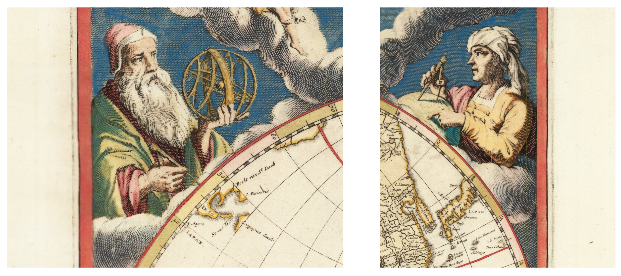
Close ups of two sections of Johannes Blaeu’s (1659) World Map depicting men of science and philosophy.
Ontological hierarchy
Colonial mapping in particular reflects an Enlightenment logic that mobilised a certain way of seeing the world that was designed within a European worldview that privileged a scientific way of knowing and simultaneously subordinated other ways of seeing and interpreting the world (Garuba, 2002). The Mercator projection, for example, upon which most maps, including Ortelius’ ‘Africae Tabula Nova’ (1570) thereafter were based “showed the latitude and longitude grid, corrected for the Earth’s curvature so lines of a compass heading could be represented on the chart as straight lines, making it much easier for mariners to keep track on the chart of a route sailed by dead reckoning” (Rozwadowski, 2018: 83–84). Gerard Mercator, known for his treatise on triangulation became known as the father of cartography who considered the globe as a scientific instrument and the world as a physical surface to be scientifically measured (Bellone et al., 2020: 25). His famous projection is an example of how the whole world can be morphed to suit the needs and desires of the mapmaker. This projection distorts the size of land masses so that the oceans can be more easily navigated and emphasises the size of the global North, de-emphasising the size of the global South. In this way, the Mercator projection - or any cartographic projection captures space and represents it through the eyes of the map-maker - homogenising and erasing localised understandings of space and relations in and to space. Through a process of abstraction, where complex and dynamic realities are simplified and represented in two-dimensional space, some objects and features are deemed more important and are given greater emphasis, while others are de-prioritised or excluded and silenced altogether (Harley, 1988). The Mercator projection also presented mariners with a universal language. It represented a standardised mapping of ocean space that was accompanied by standard charts and tools that would enable mariners and maritime imperial nations to better control and exploit the trade routes. “By systematically amassing topographical and statistical data, thereby subjecting them to the cartographic grid, cartography converted space into a visible object of knowledge which could be controlled, occupied and then managed” (Mukherjee, 2021: 65). By selecting and privileging certain objects and perspectives over others, a hierarchy of what is important and what is not arises. Due to this claim of objectivity and a map’s perceived ability to accurately mirror reality, taken at face-value, a map has the power to dictate what is real and not real and thus can and does claim ontological superiority.
This superiority also functions through a map’s implicit claim of being universally true and applicable. Scientific mapping is often presented as a universal language that can be understood by anyone, regardless of their cultural or linguistic background. This claim to universality empowers scientific mapping with ontological authority by positioning the map as a universal tool for communication and understanding. However, critical cartographers argue that maps are always situated within a particular cultural context, and the meanings and interpretations of maps are shaped by these cultural contexts and the ontologies that underpin them. The claim to the real is also achieved through the sanctioned authority of the scientists who produce the maps who are endowed as experts and thus the only ones capable of representing reality accurately, positioning scientific maps as the most legitimate and authoritative way of representing the world. Exemplifying this, countless maps in this study are adorned with superfluent titles similar to that of Overton’s (Overton, 1666) map of the African continent that reads “a new and most exact map of Africa” or Bowen’s map (Bowen, 1747) that reads, “drawn from the best authorities, assisted by the most approved charts and maps, and adjusted by astronomical observations”.
“To this end”, writes John Pickles (2004: 4), “the world has literally been made, domesticated, and ordered by drawing lines, distinctions, taxonomies, and hierarchies: Europe and its others, West and non-West, or people with history and people without history. Through their gaze, gridding, and architectures, the sciences have spatialized and produced the world we inhabit. And, indeed, this is perhaps the crucial issue: maps provide the very conditions of possibility for the worlds we inhabit and the subjects we become.”
Mapping for connection: lessons from an Empatheatre mapping process
Performative mapping, the event as an optimal disruption
Considering then the many ways in which we have shown the colonial legacy of maps that ontologically distort knowledge and context, separate people from nature, and make generalisations about particularities, we now focus on an example of mapping from South Africa. With the understanding that we have been looking at maps at smaller scales and registers than this context, we use this case study, only as an example of ways of mapping differently that might offer mapping principles and approaches that can respond to the violent reification legacies of maps, and their role in sustaining ecological apartheid in the global South.
Conceptualising maps firstly from a performative perspective, maps and map-making can become agents that shape our understanding of the world and the ways we interact with it (Pickles, 2004). Furthermore, the maps themselves become ‘artefacts of agency’ (Gell, 1998) where imbedded in them are rich forms of knowledge(s) and meaning-making praxis. In this context the actual making of the map is a form of conceptualising, or as Erin Manning (2016) explains, making is a form of thinking, conceptualising and theory building in its own right.
The performative praxis of making informs meaning, and the meaning further informs the making (McGarry, 2023). If our attention shifts towards the performative praxis of mapping itself and expands to attend to the ‘event’ (Manning, 2016) of mapping, we begin to see that the maps not only represent the world but also provide the conditions that make it possible for us to inhabit that world and can dictate the subjectivities we assume within it. According to Manning (2016), the event is a moment of intensity that optimally disrupts established patterns and opens up new possibilities. It is a rupture in the ordinary flow of things, a moment when something unexpected happens, creating a shift in perception and experience. Focussing attention on the active performance of mapping has the potential to challenge and transform preconceived notions, habits, and ways of thinking, in the moment.
When viewing maps as process, the focus shifts from what things are to how they become, emphasising the importance of ontology (Caquard, 2015). In contrast to earlier critical work that deconstructed maps to expose their hidden meanings, current critical cartography acknowledges maps as “a compelling form of storytelling” (Caquard, 2011; 136). It is in the use of the map, the repetition of the map’s story in a “particular setting for a particular purpose” (Caquard, 2015, 229) that world-making can occur. Intentionally uncovering and making explicit the messiness of map-making processes takes a step towards undoing the tether of objective and value-free science and its mapping where a map bares no dust of its makers and making. Like Gerlach (2018): 90) states, “it is no longer controversial to suggest that mapping goes beyond the lines, contours and legends of the paper map, leaking instead throughout many different genres of life: artistic, playful and experimental.”
Empatheatre’s: Umkhosi Wenala – A festival of abundance
This is precisely what Empatheatre3 undertook in their collaboration with the Mbazwana Arts Centre in Northern Kwa-Zulu Natal in South Africa from June 2021- June 2023. Using an expanded research theatre (Coppen, 2019) and public storytelling methodology (Erwin, 2021), Empatheatre comprises iterative, collaborative methodological stages and principles to ensure meaningful and transgressive, transdisciplinary, and trans-epistemological research that is accessible and inclusive (Erwin et al., 2022).
Roughly laid out, the methodology begins in the first stage with co-defining concerns, reframing cultural and historical contexts, and building contextual profiles with a variety of knowledge holders (Empatheatre, 2019). The second stage sees participants surfacing stories in relation to the concerns and context and drawing from interviews, focus groups, archival research and other methods, builds a rich data set of stories related to the concern and context (Empatheatre, 2019) (Figure 3). Stage three sees a collaborative analysis of these stories in the form of script development, through a series of ‘call and response’ iterations with knowledge holders, storytellers and other key collaborators. The team refine the script and tend to issues regarding the ethics of representation, ensuring a rich, thickly-described and multi-faceted story is compiled (Empatheatre, 2019). Stage four sees the development of a production for public performance, with further iterations with knowledge holders, until finally, in stage five, performances are rolled out and performed with rich and diverse audiences who hold different levels of agency and power in relation to the concern surfaced (Empatheatre, 2019).
Figure 3
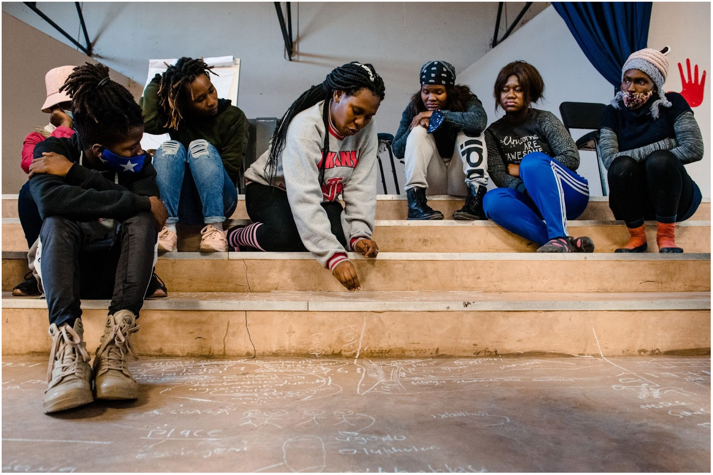
Noxolo Mlungwana sketching out stories she had unearthed in chalk in the Mbazwana Arts Centre, in Northern Kwa-Zulu Natal. She is surrounded by he fellow performers and researchers (left to right: Siphamandla Mafuleka, Nelisiwe Mbuyazi, Phindile Gumede, Sinethemba Nomandla, Snothando Ndlovu).
In this production entitled “Umkhosi Wenala4: A festival of Abundance” participants, which included 13 young activists and local storytellers/performers; were encouraged to gather and surface stories in their families and communities, particularly around the histories of forced removals, land grabbing, Marine Protected Areas and associated fortress conservation measures, and other coastal spatial changes that had happened in the region. As half the group are either young isangomas (traditional healers and diviners), or in the process of ukuthwasa5, there was a strong focus on the spiritual complexities that young isangomas have to face navigating the world today. The participants spent a year gathering stories and interviewing family members, and received data each month to stay connected in a WhatsApp group. The group became an important part of their social cohesion, friendship building and psycho-social support.
The goal of the project aimed to create a novel democratic decision-making space for rural youth in northern Kwa-Zulu Natal, South Africa through the process of restorative public storytelling. Particularly important to the project was to include voices and perspectives that have been excluded in the biodiversity conservation planning and subsequent zonation of the UNESCO world heritage site heritage site of Isimangaliso World Heritage Park that excludes cultural, spiritual, and other local perspectives. The project aimed to proactively co-create maps that surfaced the last 200 years of history from the perspective of local Indigenous peoples and in their own languages, which could be used in future conservation planning. These exclusions have been extremely violent. Within the timeframe of creating the map and play in the region, two young brothers (the Mduli brothers) were violently shot and killed almost a year apart by park rangers for fishing in the Isimangaliso conservation area. The colonial maps and subsequent biodiversity maps of the region that govern the zonation and conservation management, have played a role in this particular form of violent exclusion. During the construction of the play, the Empatheatre team were granted permission by the bereaved Mother of the sons to write a lament, which is performed and sung with great pathos by Phindile Gumede, a member of the Mbazwana Arts Center. The family of the Mudli brothers reflected that this scene felt like a memorial for the family, and thus the play was dedicated to the Mduli family.
Central to the Empatheatre methodology of this project was to co-create spatial and temporal maps, which lead to the creation of a fictional map (Figure 4). While fictional, it closely resembled local contexts and histories but utilised imaginative proxies to remove any discomfort for people associated with the stories and places and to follow a strict code of practice regarding the ethics of representation which was carefully co-defined throughout the project. We do not assume this solves the temporal and spatial quandary Lombard et al. (2023) refer to, ie. how various sectors employ either temporal or spatial methods to strategise ocean utilisation, leading to divergent conclusions regarding biodiversity management. However, we feel that storytelling as mapping could offer something valuable to the integrated approach they call for, one that includes temporal and spatial approaches to facilitate adaptive governance.
Figure 4
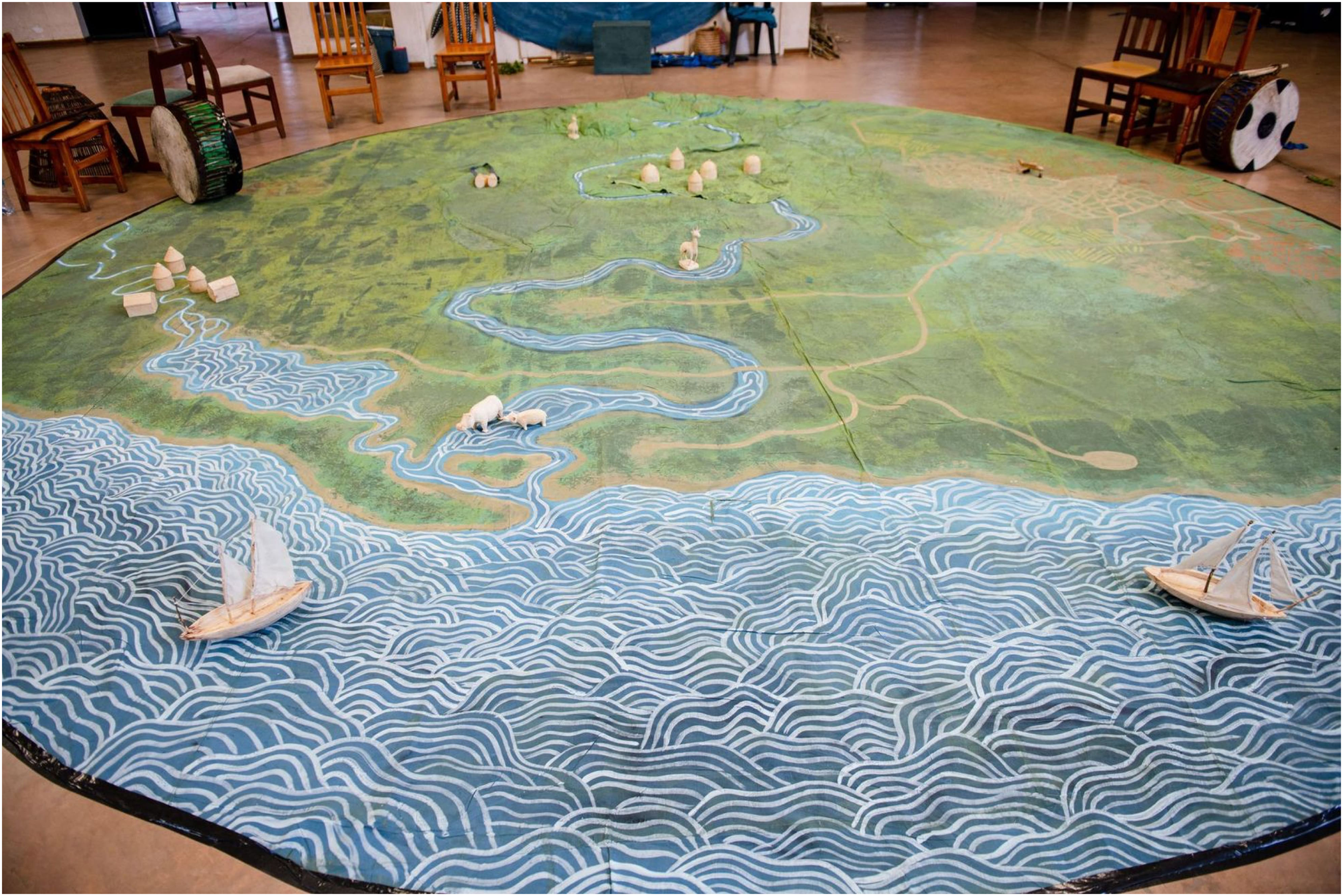
The final performance floor cloth and map, which represented a fictional community, with place names for regions, homesteads, rivers and cultural sites of significance, along with dynamic aspects of the map which could be peeled away, to represent how landscapes changed over time, due to different social, cultural, political and environmental influences.
Some key elements of the methodology used in this project are teased out here to support a re-framing of what Performative Mapping through public storytelling and collective meaning-making looks like.
Call and Response
‘Call and Response’ is an integral method to the map-making process within Empatheatre. Inspired by Kulundu-Bolus (2020): 113) who describes the “call and response tradition of singing in Africa, where one person sings a phrase, and inspired by their contribution, the crowd sings back; this becomes an intuitive ongoing iterative process of improvisation and meaning making together”. Learning and meaning making therefore benefit from this approach where knowledge co-production can be “contextually responsive, adaptive and moves towards solidarity in this time of crisis” (Kulundu-Bolus, 2020: 113).
From the beginning of the Empatheatre process, drawing from transgressive learning theory, participants were invited to co-define their concerns (Lotz-Sisitka et al, 2016) about a particular matter; in this case, this is the first ‘call’ to the collective. The call asked for local community concerns regarding the ocean and their relationship to it. Importantly, these calls are spoken in the vernacular of the community (isiZulu) and in doing so, make room for idiomatic thinking and meaning making (Mkhize and Ntšekhe, 2021). These concerns are then listened and responded to by the Empatheatre practitioners as well as the co-participants. This involves firstly, a process of attentive listening and staying with what has been told (McGarry, 2014). It should be noted that in contexts where communities have experienced various forms of collective and personal trauma, as in this region, this process is extremely sensitive; the ‘staying with’ praxis provides a forum - not to solve problems that have arose from such trauma – as this would be the domain of psycho-social practitioners (e.g., social workers, traditional healers) – but to respectfully listen and engage in active empathy.
After ‘attentive listening’ and ‘staying with’, questions, clarifications, and examples can be asked to develop and deepen the shared understanding of the matters of concern. Co-defining ‘matters of concern’ as opposed to ‘matters of fact’ (Latour, 2004) is another important layer of iterative call and response, enabling the group to develop a shared understanding from which a first map could be made. The storytelling and the story-listening were held carefully in balance, and careful attentiveness was aided by ‘making as a form of thinking’ (Manning, 2016). The embodied practice of sketching out and writing stories in chalk together on the cement floor of the Mbazwana Arts Centre’s hall provided a material visualisation of place-making and meaning-making, as well as relational, kinship and other forms of social mapping. When considering map-as-performance in this context, it begins with a call and response to inform the relational mapping of concerns, which, in turn, begins to sculpt and make visible the empathetic ‘invisible materials’ between people (Sacks, 2018).
This is a care-full and iterative process that draws on the Call-and-Response meaning-making and provides a useful framework for receiving continual contributions from those who are being sought for their input. This methodology breaks away from a tick-box consultation exercise that has, so far, characterised public participation where maps and plans for biodiversity conservation planning and Marine Protected Areas (MPA) processes that have already been decided on by external actors are displayed on a PowerPoint in community meetings in English, outside of their local language. The Empatheatre approach moves towards meaningful relationship building and frequent and ongoing participation from beginning to end, in which new maps are created that live - not just in two dimensional renders but are assembled with performative storytelling and collective meaning making and connective aesthetics.
This process also implies that the map does not necessarily begin with the data or the material or digital production of the map but begins when the necessary people are brought together to begin the process of collectively deciding why we are mapping? For whom are we mapping? And what is to be mapped? This approach also implies that the map is never finished; and is rather an ongoing collaborative process. This type of mapping is a process of collective thinking, and as Manning (2016): 28) describes that ‘making as thinking’ redirects the focus of meaning making and research away from the final object (in this case the map) towards the ‘way’ or ‘manner’ of thinking together, which fundamentally re-orients the ‘knower-known relation’.
In other words, the social relations embedded in mapping (verb) is just as – if not more important that the material map (noun). As Manning (2016): 30) explains:
“…Neither the knower nor the known can be situated in advance of the occasions coming to be - both are immanent to the field’s composition. Nor can the knower-known relation be classified independently of the ecologies that compose it, including those who register it unquantifiable, such as the quality or affective tonality of experience”.
This approach to mapping as a practice of thinking together, therefore includes a rich and thickly described texture of local social, cultural, economic, political context and ecological assemblages. Indeed, in the Mbazwana Arts Centre hall, we gathered over four days around a growing chalk map of stories (approximately 20m2 wide) and their relationships, with layers upon layers of power analyses and contextual nuance, which were negotiated and re-shaped each day. Furthermore, with each iteration of the map, it ensured that it could increasingly reflect the needs and relations of the group as its collective understanding of concerns changed or deepened (Figure 5).
Figure 5
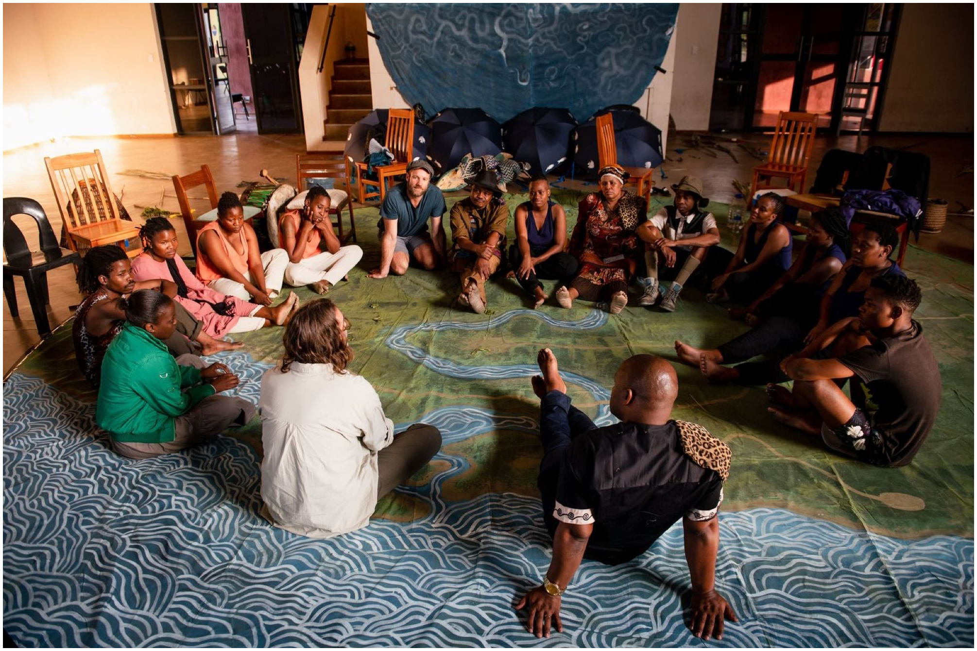
The Mbazwana Arts cast and Empatheatre Team, debriefing after a production of the play, gathered on the collectively rendered map, co-created by the whole community.
Finally, we have learned that the Call and Response as a meaning-making process transforms local community members from objects to be mapped into active subjects or ecological citizens that are invited to map themselves and their relationality with the ocean and its biodiversity, inherently transforming the power relations between the mapmaker(s) and the mapped, and creating space for power and parity to be negotiated collectively. After elders and knowledge holders had had two iterative contributions to the expanding map of time (200 years of history) and space (the region both physical and spiritual surrounding the MPA), the fictional map of a world - similar but suitably strange (McGarry, 2022), when compared to the non-fiction map was co-produced. Subsequently, the Empatheatre team created a floor cloth for the performance (10m in diameter) which had soft sculpture fabric mountains, rivers, and coastline painted in graphic detail. New, fictional Zulu placenames were developed to reflect specific moments in history where names of places were associated with moments of significance and concern identified by the co-researchers and knowledge holders. This circular fabric map became the stage upon which stories would be performed. Working closely with local artisans in woodcarving, painting and weaving, puppetry, and props, like small houses to mark villages, animals, colonial ships, and masks were created to be included in the performance as we moved through the 200-year history. This allowed, for example, for dramatic and deeply embodied portrayals of forced removals and rising fences of the MPA to be retold with pathos and humour, and could offer aesthetic arrest (Joyce, 2008) and a connective aesthetic (Gablik, 1992) that provided metaphor and semiotic meaning-making. These also offered new translation protocols that can exist outside of language and ‘textual’ reasoning.
Language and storytelling
Even with connective aesthetics, metaphor and symbol, it is important to note that these mapping processes were carried out in the preferred language/s of the local community. In this case it was isiZulu. English is the hegemonic language of environmental governance in South Africa and is exclusionary to anyone who does not feel confident speaking it. Furthermore, English very often does not and cannot capture the true essence of what someone intends to communicate if English is not their first language. When working in vernacular, customary knowledge and lore/laws around customary governance has a better chance of entering into the mapping process. Through translation, symbolic, idiomatic and semiotic reasoning can be lost in translation, and as a result, dilute knowledge(s). Translation cannot be an afterthought; it must be considered central to any meaningful participatory mapping process.
This lesson not only refers to the inequality around the elevation and subordination of certain national languages but also to the hegemony of the discursive language of Science. The science informing environmental governance in South Africa is communicated primarily in English. In addition to this first layer of exclusion, the communication of science is often very technical and requires a certain level of scientific understanding garnered from a technical or scientific institution. In other words, science is jargon-heavy and exclusionary for those who have not been exposed to it or enabled to understand it. Scientific language also comes with its own politics, power, and assumptions that cannot see or feel into the lived experience of people who are essentially being mapped out of their own lands. Working in vernacular language ensures science and the dominant English language must labour to meet localised meaning-making and witness its own assumptions and blind spots, which quickly surface when science is translated into vernacular.
Lupin and Townsend (2023:103) bring attention to underlying obstacles that result in the suppression of local perspectives and voices. Firstly, they emphasise the necessity of dispelling ‘prejudicial stereotypes’ concerning the legitimacy and trustworthiness of diverse knowledge holders, thus dispelling ‘misconceptions’ regarding their capacity to offer valuable insights. Secondly, they (Lupin and Townsend (2023):103) advocate for preventing any ‘unfair distribution of conceptual resources needed for speakers to have a say,’ highlighting the importance of culturally suitable and readily accessible resources to enable meaningful participation.
Mapping in the Empatheatre process aims to ‘meet the universe halfway’6 (Barad, 1996) and thus not only seeks to elevate Indigenous languages by de-centering English as the language of participation but to also recognise the value of linguistic devices or translation protocols (Erwin, 2021), such as metaphor and storytelling that are embedded within Indigenous languages and worlds. Donna Haraway explains, ‘it matters what stories, story stories’ (2016: 35). In other words, it’s important that stories are located and felt in the relationships between people who tell them. In instances of potential conflict, drawing on metaphor can help to develop shared understanding of phenomena between culturally distinct groups and help to unearth a sometimes-inexpressible reality, without reifying complex felt experiences into sterile words and translated textual definitions. Metaphors are illustrated in short fables and vignettes throughout the play that refer to particular customary practices, such as, balancing estuary use between humans and hippos, or the customary ‘stock assessments’ and associated traditional fisheries management undertaken through song and praise poetry connected to the corralling of fish using traditional ‘isibaya’ or fish traps/kraals.
Ultimately, the mapping process is a storytelling/listening practice that connects stories to place; an interdisciplinary methodology (McKittrick, 2020) of place-making or what bell hooks (2009: 143) calls a “place where the soul can rest” and as Kulundu-Bolus (2020): 270) would add “for the soul to show up in their own way”. Even scientific maps tell stories, produce narratives, and produce (or at least render) place. But mapping-as-performance questions the seemingly discrete and absolute stories that such maps tell and explicitly aims to bare the dust of the data that goes into their production. Mapping-as-performance brings into question what kind of data is valid for mapping biodiversity.
The “Umkhosi Wenala” performance undertaken on the map validates multiple forms of data; stories are data, dance and song are data that can and should be mapped in the context of marine biodiversity governance (Figure 6). When storytelling is taken seriously, story-listening also becomes critical to the process of mapping. We must “…become story-listeners before we become storytellers. Here we have a great responsibility to the people, places, and things we are empathising with, and with the concerns that are being surfaced” (McGarry (2022): 99). Particularly in the field of science, where scientists typically only engage in two-way communicative processes with each other, a call to listen to local and Indigenous knowledge holders is a powerful move towards transforming both – what counts as data and evidence and whose knowledge counts.
Figure 6
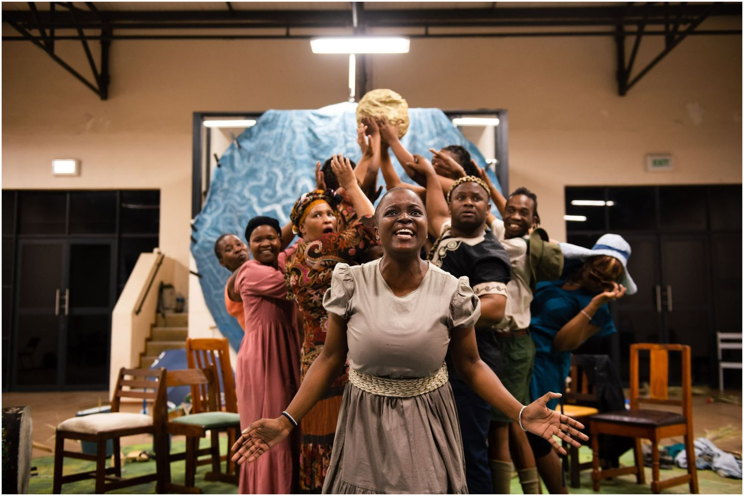
Mbali Ntuli, centre stage, performing the final monologue of the play on the co-constructed map, where she reflects on the decisions made around her land, and oceans by previous generations.
Challenging knowledge hierarchies
Biodiversity mapping carried out for conservation planning is achieved through science and technology, requiring instrumentation, measurement, quantification, and generalisation and extrapolation. Indeed Ntona and Schröder (2020) argue that the ‘techno-science’-driven nature of ocean mapping makes it unlikely that Indigenous and local values will inform future regulatory reforms in MSP. This statistical scientific approach renders knowledge that is unquantifiable incompatible with scientific mapping practices and is consequently rarely included, or at the very least is under prioritised (Ritchie and Ellis, 2010; Boucquey et al., 2016; Smith and Jentoft, 2017; Smith, 2018; Flannery et al., 2019). Despite this, often, even local knowledge that can be quantified easily (e.g., total catch, or how far from the shore a fisher travels, or stock assessments made by fishers) are not included in maps - not due to the incompatibility of the data but due to asymmetries of power and subsequent active and passive exclusions of different actors and their knowledge(s) (Ntona and Schröder, 2020).
In our research of marine biodiversity science transformation many blind spots remain to some of the cultural barriers that have kept some black and brown scientists from entering the field of marine science. This highlights the need to expand the ways in which science can meet Indigenous meaning making. In South Africa, for many families it is believed the ancestors dwell in the oceans (McGarry, 2023), and so children are forbidden from a young age from entering the sea, as fear of being taken into the sea by the ancestors is very real. Only recently, marine scientists like Dr. Kerry Sink have provided expanded scholarships that can cover the cost of specific rituals and ceremonies needed to appease the ancestors, and gain permission to enter the sea in their pursuit of marine science (Sink, 2020: pers com). Transforming marine science, especially marine biodiversity science, in such ways this could improve the ways in which customary lore/laws of managing and understanding biodiversity and ecological systems can and should include Indigenous knowledge.
Rather than trying to quantify traditional knowledge which often resists objectification and quantification, mapping in an Empatheatre process explicitly recognises traditional knowledge - not only in its ability to complement science but its intrinsic value to contribute to ocean and marine biodiversity governance through surfacing and affirming customary lore/law. We consider it potentially dangerous to ‘bring in’ Indigenous knowledge into a scientific framework and its ‘ways of doing’; a careful negotiation of knowledge integration is needed to delicately shift the scales of influence and representation.
Quantification of traditional knowledge implies that science and scientists are the ones doing the ‘bringing in’ and thus are still dictating (often blindly) the rules of the map and the mapping process. Consequently, information that is more readily quantifiable is explicitly recognised and thus more easily incorporated into the map, absenting less quantifiable knowledge such as intangible heritages. As stated previously, it is not to say that Indigenous knowledge cannot be quantified but asking questions around what should and should not be quantified needs to be explicit, and the ethics of representation of this knowledge must be co-defined and iteratively rendered.
Indeed, this is one of the key aspects of Empatheatre methodology, using ‘call-and-response’ collaborative iterations over time, across and through different knowledge holders with different levels of agency and power, enable greater ethical representation. The quantification of Indigenous knowledge however ensures that scientific hegemony remains. Other ways of recognising, valuing, and drawing on such knowledges, including ways that respect Indigenous knowledge in its form are explored in mapping-as-performance by arguing that the rules of the map must change to accommodate non-quantitative information and knowledge – as opposed to dictating that the Indigenous knowledge must be transformed. In mapping-as-performance, dance, song, and story are forms of data, and are included with(in) the map and its performance. This recognition again shifts the power dynamics of mapping and the knowledge that is typically considered worth mapping.
Relationality is at the centre of Indigenous worlds (Littletree et al., 2020). Such worlds are upheld by and through relationships with multiple species; human, non-human, and more-than-human (Kimmerer, 2013). A focus on relational knowledge is a way to overcome the binaries between humans and nature, an obstacle that is difficult to overcome within Western-scientific ways of knowing and being. It is a way of understanding the interconnectedness of the social, cultural, political, ecological, and spiritual spheres of activity that characterise human relations with the ocean and its biodiversity. Uncovering relational understandings of the world enables a recognition of response-ability (Haraway, 2016: 35) towards certain relationships, highlighting one’s agency to either enable or disable a particular relationship. If we consider that biodiveristy planning, spatial mapping and conservation zonation for example, are fundamentally about mapping complex human/nature relations, then a focus on relational knowledge and ontologies can contribute significantly to a knowledge base for marine biodiversity governance. As Manning (2016): 31) posits, “…To engage the field of relation as an ecology where knowledge occurs, to place knowledge outside the register of existing knower-known relations, allows us to consider the importance of what escapes the register.” In our experience of the tools and practices used to design and manage biodiversity conservation planning in South Africa, much is escaping the register.
Indigenous ways of knowing require the acknowledgement of the spiritual dimension of knowledge and intangible knowledge not capturable by Science, but has the potential to be rendered (through care-full ethics of representation) and held in conversation with science in diverse formats through visual art, storytelling, prose, music, dance, etc. Creative practice and ‘making-thinking’ through art allows for intangible heritage to be included and held in the ecology of knowledges (De Sousa Santos, 2015) and overall mapping and management practice. This has indeed occurred, where customary rights holders in recent court cases against the Dutch oil and gas giant Shell, in South African jurisprudence challenged evidence hierarchies by including animations, an Empatheatre radio play and other artwork and poetry in their case, which held the nuanced spiritual and intangible heritages of the ocean that were later mentioned and acknowledged in a court judgement. This was the first time the presence of the ancestors and the sacredness of the ocean was recognised by South African law (McGarry, 2023).
Discussion
We have shown in this paper that the relationships between colonialism, Science, and cartography have had a significant impact on human-ocean relationships and critically - the significance of how these relationships are represented publicly through the (re)production of maps. Drawing on decolonial theorists and scholars from PCSTS, we have sought to detangle some of the threads that tie together the ocean, its role in colonial conquest and how these were intimately intertwined with the scientific mapping of ocean space. We distil how European cartography from the 15th century onwards began to reflect the values of a modern and enlightened science that facilitated colonial and capitalist-mercantile agendas. This entwinement contributed to the narrative of empty, uninhabited lands and uncharted, exploitable oceans awaiting capture by European colonial powers.
We have uncovered some of the epistemological residues that mapping continues to employ. Modern systematic maps rely on a standardised form of knowledge (universal measurements, standardised tools, a standard set of data criteria to plot etc.) and while valuable and useful for representing certain characteristics of a seascape do not do so objectively and thus establish a prescribed set of possibilities for seeing, knowing, and being (Turnbull, 2000). We argue the scientist’s or cartographer’s partial knowledge is relevant and interesting, but only as part of a bigger picture. Following critical cartography, we argue, that maps are not neutral and through processes that abstract, oversimplify, and distort space and identities, can often reinforce normative power relations and obscure and effectively erase the social and political dimensions of mapping and the world it represents. We argue that maps are not mirrors of a singular reality but are products of social and power-laden relations that reflect the knowledge systems and societies of their mapmakers and thus contain an inherent blindness to other ways of knowing, being and doing in the world.
We have shown that the development of colonial mapping emerged in parallel with the Scientific Revolution flourishing in 16th century Europe, which prioritised empirical observation and objectivity. Cartesian logic and perspective were used in early modern mapping to create a sense of detachment between humans and nature, portraying nature as a set of discrete objects that could be studied, known, and controlled. Haraway’s work problematises the notion of a supposedly disembodied scientist in their claims to objectivity and universal knowledge production; a phenomenon she refers to as a ‘god trick’, or ‘view from nowhere’ that ignores human limitations, convinces us objectivity is possible and obscures from us questions concerning who has the authority to look and from where (Haraway, 1988). Scientists have sought to create visual and spatial representations of nature, effectively separating it from the realm of human experience, creating a hierarchy between humans and nature, an ecological apartheid and limiting our understanding of the biocultural relationalities that shape the environment.
By bringing together perspectives from decolonial theory and critical cartography, we draw attention to the role of mapping and mapping practices within spatially based conservation planning and marine governance processes and how they are embedded in and shape the possibilities for control of the ocean, its biodiversity, its people, and their relationality. The colonial roots and residues of mapping for control of the ocean space continue to manifest presently, further embedding inequality, ontological hierarchy, and marginalising ocean citizens, Indigenous and local knowledge, and reifying ocean imaginaries. If the Blue Economy in South Africa is to be equitable and transformative, the ways in which the ocean is understood and mapped for management decisions must be reconsidered. We argue that new mapping imaginaries need to be explored, ones that involve local people, can work with social-ecological complexity, move beyond positivist framings of time/space/matter and do not reproduce inequitable power relations – both ontologically and epistemologically.
Understanding the ontologies through which current approaches to mapping biodiversity emerge are critical if contemporary ocean related mapping is not to reproduce the same embedded inequalities that colonial mapping established (Peters, 2020). Rather, mapping should respond to past injustices and be a meaningful and useful tool for decision making that thickly describes the relationality and the lives that are entangled with the ocean. This is not just our finding, but also a pre-existing international obligation of the Convention on Biological Diversity (CBD), where if and how to comply with such an obligation is still being grappled with by many countries (Morgera, 2017).
The society in which we live has been produced and can therefore be reproduced differently and thus accompanying our argument is a demand that contemporary scientific practice recognise its colonial and capitalist roots and look for ways of doing science ‘otherwise’ – through approaches that harness its power and works towards transformation. The reality is that this counterhegemonic mapping is still attempting to challenge existing governance structures which still mirror western governance machinery. We cannot say that transforming mapping alone can solve all the problems, but rather it is one of the many transformations that have and need to be undertaken. Much more is needed to dismantle existing governance infrastructures and institutions more generally that are so deeply entrenched in colonial projects. We hope that this iterative and dialogic approach to mapping, storytelling and listening, could begin such a generative disruption and reconfiguration of governance. In responding to the distortions in representation and power, current critical cartography acknowledges maps as a form of storytelling that makes worlds. When maps are conceptualised, not as static, and complete visions of nature, but as social, cultural processes bound up in political realities, the focus shifts to how things become, highlighting the importance of onto-epistemological renderings. This transformation of perspective offers alternative ways of mapping spatial relations and understandings of human-ocean relationalities that draw on relational ontologies. A shift to a more relational ontology within the context of mapping and marine biodiversity governance has the capacity to see the fullness and wholeness of the seascape, meaning that the ecological, the social, the cultural, and political constituents are equally understood and represented. Through relational ontologies and their innate understanding of plurality, they have the ability to work with both science and Indigenous knowledge in non-hierarchical ways where both humans and nature are, because of one another7.
The Empatheatre methodology, although scaled in the immediate local context in contrast to the larger-scale maps examined in this paper, offers an experimental alternative to traditional map-making processes that aim to address power asymmetries and state the critical importance of social relations in mapping the ocean space; we echo Stephan Helmreich (2001), when they say, “the ocean is not only a resource space used by society, but a space of society”. Society in our framing includes human and more-than-human relational entanglements, as Donna Haraway puts (Haraway, 1997: 137): “nothing comes without its world”. These experiments offer some key principles or practices that can inform future mapping cultures. Such as:
-
• Using a “call-and-response” process, which is a collaborative and iterative mapping process that draws on empathetic meaning-making and provides a useful framework and toolkit that inspire continuous consultative input from those who have stakes in the relationships and places being mapped.
-
• Working in vernacular language, idiom, story and metaphor, as a means to create meaningful translation protocols in mapping practice.
-
• Challenging knowledge hierarchies through story, and performative historical analysis that include power and agency in their telling.
-
• Creating worlds and maps that do-not claim to mirror the world, but offer multifaceted, complex and relational renderings of time, space and meaning.
-
• Using connective aesthetics, co-defining practices, dialogical engagement with maps, and seeing the map as a place where “the soul can show up in its own right” (Kulundu-Bolus, 2020).
Umkhosi Wenala seeks to deconstruct the work of maps and the science that produces them and quests to frame contested coastal landscapes in more fruitful, performative ways that transform the power-laden process of mapping, emphasises connectivity and recognises other ways of knowing and being. The performance toured the Kwa-Zulu Natal region over two weeks and received extraordinary responses. Performances involved post-show dialogue that transformed performance into impromptu public tribunals, where audiences engaged with the map, the stories, and performers in rendering their facets of history into the living archive that was the map and show. This event aimed to create new maps that reflect the multiple ontologies that characterise the complexity of a socio-ecological space and harness the power of ocean stories that have been scribbled off the colonial maps of conquest and re-story the contours of the coastline.
The entwined relationships between Science, colonialism, and cartography have had significant impacts on human-ocean relationships, particularly in terms of marine biodiversity governance. However, current critical and counter-hegemonic mapping, such as that undertaken by Empatheatre, suggests alternative ways of mapping and understanding human-ocean relations can benefit from more relational ontological knowledge co-production; ones that can consider the social and cultural dimensions of marine biodiversity governance and the different ways in which people relate to the ocean. In essence, how we map the ocean and its biodiversity will require collective relational effort, creativity, and a commitment to storying and restoring the world, in ways that might not be conveniently rendered, and may even be more complex than we can imagine. They will possibly come with songs of lament, with fabric maps underfoot, with hand-carved small houses in hand, and choreographed movements that remember past injustices, as they do in the play Umkhosi Wenala. As Frank Egler (quoted by Dietrich, 2011: 120, their emphasis) states: “ecosystems may not only be more complex than we think, they may be more complex than we can think.” So too, counter-hegemonic mapping will require ways of thinking that move well beyond our conventions. The future of just and inclusive ocean decision-making, that can even begin to grapple with social-ecological complexity of the worlds we are entangled in, demands a sincere commitment to move away from mapping as a form of control, and towards mapping for connection.
Statements
Data availability statement
The datasets presented in this article cannot be publicly shared due to privacy restrictions. Requests to access the datasets should be directed to the corresponding author/s.
Ethics statement
The studies involving humans were approved by Environmental & Geographical Science, University of Cape Town and Environmental Learning Centre, University of Rhodes. The studies were conducted in accordance with the local legislation and institutional requirements. The participants provided their written informed consent to participate in this study. Written informed consent was obtained from the individual(s) for the publication of any potentially identifiable images or data included in this article.
Author contributions
JW: Conceptualization, Data curation, Formal analysis, Investigation, Methodology, Project administration, Visualization, Writing – original draft, Writing – review & editing. DM: Conceptualization, Data curation, Formal analysis, Funding acquisition, Investigation, Methodology, Supervision, Writing – review & editing.
Funding
The author(s) declare financial support was received for the research, authorship, and/or publication of this article. This Research was funded by UK Research and Innovation (UKRI) through the Global Challenges Research Fund (GCRF) (Grant Ref: NE/S008950/1) and South African Research Chairs Initiative of the Department of Science and Innovation and National Research Foundation of South Africa.
Conflict of interest
The authors declare that the research was conducted in the absence of any commercial or financial relationships that could be construed as a potential conflict of interest.
Publisher’s note
All claims expressed in this article are solely those of the authors and do not necessarily represent those of their affiliated organizations, or those of the publisher, the editors and the reviewers. Any product that may be evaluated in this article, or claim that may be made by its manufacturer, is not guaranteed or endorsed by the publisher.
Footnotes
1.^See Positionality section on our distinction between Science with a capital ‘S’ and science with a lower-case ‘s’.
2.^We identify with the term "scholar activist" which refers individuals or groups who actively engage in scholarly work while simultaneously working towards social change and addressing societal issues. The figuration of which emphasizes the integration of academic knowledge and research with practical activism and advocacy, which we undertake in relation to knowledge action networks such as the Coastal Justice Network (CJN) www.coastaljustice.org. While the is no generally accepted definition for "scholar activist," the concept has been discussed and explored by various scholars and researchers (Wright, 2005; Quaye et al, 2017).
3.^Empatheatre is a public storytelling and research theatre collective, that has been operating since 2014. It responds to critical social and ecological concerns that are co-defined by vulnerable groups, and sculpts the invisible materials within social tissue, such as empathy, as a contribution to conflict transformation (Rodríguez & Inturias, 2018). and transgressive learning (Lotz-Sisitka et al, 2016). See www.empatheatre.com.
4.^A documentary about the production can be see here: https://www.youtube.com/watch?v=Qb6pS_fIZH0.
5.^The Zulu word ukuthwasa is derived from thwasa which means 'the light of the new moon' or from ku mu thwasisa meaning 'to be led to the light'. A trainee sangoma (a traditional healer/diviner - or ithwasane) trains formally under another sangoma for a period of anywhere between a number of months and many years. For some, ukuThwasa can involve traveling to a mythical realm beneath the sea, where a trainee visits wise ancestors, who pass on special gifts (Kubeka, 2016).
6.^By this Barad (1996) means that human perception and knowledge production are not simply a passive observation or representation of pre-existing reality, but rather an active and ongoing process of negotiation with the world around us. Meaning, we cannot fully comprehend the world without considering our own role in shaping and influencing it. Here Empatheatre, recognises the co-creative relationality to our understanding of the world, and that our own perspectives, histories, worldviews and actions are entangled with the material world. This is keenly experienced in the co-construction of the 200 year history in relation to the collaborative cartography of the map, and the multi-faceted ways in which people, ancestors, animals and the political force of colonialism are all negotiating and co-constructing realties and historical narratives that echo from them.
7.^This echoes the Zulu proverb, Umuntu ngumuntu nbabantu, which directly translated into English means a person is a person through other persons (Nabudere, 2005).
References
1
Adams W. B. Mulligan M. (2012). Decolonizing nature: strategies for conservation in a post-colonial era (London: Routledge). doi: 10.4324/9781849770927
2
Barad K. (1996). Meeting the universe halfway: Realism and social constructivism without contradiction. In Feminism, science, and the philosophy of science. (Dordrecht: Springer Netherlands), pp.161–194.
3
Beaujard P. (2020). Early maritime cultures in East Africa and the Western Indian Ocean. Oxford: Archaeopress; 978-1-78491-712-8 paperback£ 48. Antiquity94, 267–269. doi: 10.15184/aqy.2019.222
4
Bellone T. Engel-Di Mauro S. Fiermonte F. Armano E. Quiquivix L. (2020). “Mapping as tacit representations of the colonial gaze,” in Mapping crisis: Participation, datafication and humanitarianism in the age of digital mapping (Chicago: University of Chicago Press), 17–38.
5
Blaeu J. (1659). Modern and completely correct map of the entire world (Amsterdam: Joan Blaeu). Available at: https://www.loc.gov/item/2021668302/.
6
Bleau W. (1644). Africae nova descriptio. Available online at: https://library.princeton.edu/visual_materials/maps/websites/africa/maps-continent/1644%20blaeu.jpg.
7
Boucquey N. Fairbanks L. Martin K. Campbell L. M. McCay B. (2016). The ontological politics of marine spatial planning: Assembling the ocean and shaping the capacities of ‘community’ and ‘environment’. Geoforum75, 1–11. doi: 10.1016/j.geoforum.2016.06.014
8
Bowen E. (1747). A new and accurate map of the southern parts of Africa. Available online at: https://digitalcollections.lib.uct.ac.za/islandora/object/islandora%3A25316/datastream/OBJ/view.
9
Branch J. (2013). The cartographic state: Maps, territory, and the origins of sovereignty. Vol. 127 (Cambridge University Press).
10
Brockway L. H. (1979). Science and colonial expansion: the role of the british royal botanic gardens. Am. Ethnol.6 (3), 449–465. Available at: http://www.jstor.org/stable/643776.
11
Caquard S. (2011). Cartography I: Mapping narrative cartography. Prog. Hum. Geogr.37, 135–144. doi: 10.1177/0309132511423796
12
Caquard S. (2015). Cartography III: A post-representational perspective on cognitive cartography. Prog. Hum. Geogr.39, 225–235. doi: 10.1177/0309132514527039
13
Carey M. (1796). Africa according to the best authorities. Available online at: https://digitalcollections.lib.uct.ac.za/islandora/object/islandora%3A19698/datastream/OBJ/view.
14
Coppen N. (2019). Into Ulwembu: exploring collaborative methodologies in a research-based theatre production on street-level drug use in KwaZulu-Natal, South Africa (Doctoral dissertation). Available online at: https://researchspace.ukzn.ac.za/handle/10413/19153.
15
Cosgrove D. (1999). Mappings (London: Reaktion Books).
16
Craib R. B. (2000). Cartography and power in the conquest and creation of New Spain. Latin American Res. Review. 35(1)7–36.
17
Crampton J. W. (2013). Mappings. The Wiley‐Blackwell Companion to Cultural Geography, 423–436.
18
Cullinan C. (2011). Wild law: A manifesto for earth juctice. 2nd ed (Cornwall: TJ International).
19
Dalton C. M. Stallmann T. (2018). Counter-mapping data science. Can. Geographer/Le Géographe Canadien62, 93–101. doi: 10.1111/cag.12398
20
De Sousa Santos B. (2015). Epistemologies of the South: Justice against epistemicide (New York: Routledge).
21
Dietrich W. (2011). The final forest: big trees, forks, and the pacific northwest (Washington: University of Washington Press).
22
Edney M. H. (1997). Mapping an empire: The geographical construction of British India 1765-1843 (Chicago: University of Chicago Press). doi: 10.7208/chicago/9780226184869.001.0001
23
Ehler C. N. (2021). Two decades of progress in Marine Spatial Planning. Mar. Policy132, 104134. doi: 10.1016/j.marpol.2020.104134
24
Empatheatre (2019). What is empatheatre? Available online at: https://www.empatheatre.com/about (Accessed Accessed: 26 May 2023).
25
Erwin K. (2021). Storytelling as a political act: towards a politics of complexity and counter-hegemonic narratives. Crit. Afr. Stud.13, 237–252. doi: 10.1080/21681392.2020.1850304
26
Erwin K. Pereira T. McGarry D. Coppen N. (2022). “Lalela uLwandle: an experiment in plural governance discussions,” in The palgrave handbook of blue heritage (Springer International Publishing, Cham), 383–409.
27
Escobar A. (1998). Whose knowledge, whose nature? Biodiversity, conservation, and the political ecology of social movements. J. Polit. Ecol.5, 53–82. doi: 10.2458/v5i1.21397
28
Escobar A. (2018). Designs for the pluriverse: Radical interdependence, autonomy, and the making of worlds (North Carolina: Duke University Press). doi: 10.1215/9780822371816
29
Etherington N. (2007). Mapping colonial conquest: Australia and southern Africa (Perth, Australia: UWA Publishing).
30
Fanon F. (1965). A dying colonialism (New York: Grove Press).
31
Flannery W. Clarke J. McAteer B. (2019). “Politics and power in marine spatial planning,” in Marine spatial planning: Past, present, future. Eds. ZauchaJ.GeeK. (Palgrave Macmillan), 201–217.
32
Foucault M. (1976). The archaeology of knowledge (New York: Harper & Row).
33
Gablik S. (1992). Connective aesthetics. Am. Art6, 2–7. doi: 10.1086/424147
34
Garuba H. (2002). Mapping the land/body/subject: Colonial and postcolonial geographies in African narrative. Alternation9, 87–116.
35
Gell A. (1998). Art and agency: an anthropological theory (Oxford: Clarendon Press). doi: 10.1093/oso/9780198280132.001.0001
36
George R. Y. Wiebe S. M. (2020). Fluid decolonial futures: Water as a life, ocean citizenship and seascape relationality. New Political Sci.42, 498–520. doi: 10.1080/07393148.2020.1842706
37
Gerlach J. (2018). “Mapping as performance,” in The Routledge handbook of mapping and cartography. Eds. KentA. J.VujakovicP. (Routledge).
38
Giddens A. (1981). The contemporary critique of historical materialism: power, property and the state (London: Macmillan). doi: 10.1007/978-1-349-16638-1
39
Group Areas Act . (1950). Parliament of South Africa, The Group Areas Act, Act No. 41, 1950.
40
Grove R. Grove R. H. (1996). Green imperialism: colonial expansion, tropical island Edens and the origins of environmentalism 1600-1860 (Cambridge: Cambridge University Press).
41
Haraway D. (1988). Situated knowledges: The science question in feminism and the privilege of partial perspective. Feminist Stud.14, 575–599. doi: 10.2307/3178066
42
Haraway D. (1997). “ Modest_Witness@Second_Millennium ,” in FemaleMan©_Meets_OncoMouse™: feminism and technoscience (Routledge, New York).
43
Haraway D. (2016). “Staying with the trouble,” in Making kin in the chthulucene (Duke University Press, Durham/London). doi: 10.2307/j.ctv11cw25q
44
Harding S. (2008). Sciences from below: Feminisms, postcolonialities, and modernities (North Carolina: Duke University Press). doi: 10.2307/j.ctv11smmtn
45
Harley J. B. (1988). Silences and secrecy: the hidden agenda of cartography in early modern Europe. Imago mundi40, 57–76. doi: 10.1080/03085698808592639
46
Harris J. Livingstone Lombard A. Erwann L. Haupt P. Sink K. et al . (2012). Coastal and marine biodiversity plan for kwazulu-natal, South Africa.
47
Harvey D. (1990). The condition of postmodernity: an enquiry into the origins of cultural change (Cambridge MA & Oxford UK: Wiley).
48
Havice E. Zalik A. (2019). Ocean frontiers: epistemologies, jurisdictions, commodifications. Int. Soc. Sci. J.68. doi: 10.1111/issj.12198
49
Joyce J. (2008). A portrait of the artist as a young man (Oxford: OUP Oxford). doi: 10.1093/owc/9780199536443.001.0001
50
Kiepert H. (1897). Africa. Available online at: https://digitalcollections.lib.uct.ac.za/islandora/object/islandora%3A30090/datastream/OBJ/view.
51
Kimmerer R. (2013). Braiding sweetgrass: Indigenous wisdom, scientific knowledge and the teachings of plants (Minneapolis: Milkweed editions).
52
Kitchin R. Perkins C. Dodge M. (2011). “Thinking about maps,” in Rethinking maps (London & New York: Routledge), 19–43.
53
Kubeka N. P. (2016). The psychological perspective on Zulu ancestral calling: A phenomenological study (Pretoria, South Africa: University of Pretoria).
54
Kulundu-Bolus I. (2020). Not yet uhuru! Attuning to, re-imagining and regenerating transgressive decolonial pedagogical praxis across times. Available at: http://hdl.handle.net/10962/166081.
55
Latour B. (2004). Why has critique run out of steam? From matters of fact to matters of concern. Crit. Inq.30, 225–248. doi: 10.1086/421123
56
Littletree S. Belarde-Lewis M. Duarte M. (2020). Centering relationality: A conceptual model to advance indigenous knowledge organization practices. KO KNOWLEDGE Organ.47, 410–426. doi: 10.5771/0943-7444-2020-5
57
Lombard A. T. Clifford-Holmes J. Goodall V. Snow B. Truter H. Vrancken P. et al . (2023). Principles for transformative ocean governance. Nat. Sustain. 6 (12), 1587–1599. doi: 10.1038/s41893-023-01210-9
58
Lotz-Sisitka H. Ali M. B. Mphepo G. Chaves M. Macintyre T. Pesanayi T. et al . (2016). Co-designing research on transgressive learning in times of climate change. Curr. Opin. Environ. Sustainability20, 50–55.
59
Lupin D. Townsend L. (2023). Representation and epistemic violence. In Testimonial Injustice and Trust. (Routledge), pp. 198–215.
60
Malavasi M. (2020). The map of biodiversity mapping. Biol. Conserv.252, 108843.
61
Manning E. (2016). The minor gesture (North Carolina: Duke University Press). doi: 10.2307/j.ctv111jhg1
62
McGarry D. K. (2014). Empathy in the time of ecological apartheid: A social sculpture practice-led inquiry into developing pedagogies for ecological citizenship (Rhodes University).
63
McGarry D. (2022). Suitably Strange: Re-imagining learning, scholar-activism, and justice. Crit. Stud. Teach. Learn. (CriSTaL)10, 93–115. doi: 10.14426/cristal
64
McGarry D. (2023). “When ancestors are included in ocean decision and meaning-making,” in Hydrofeminist Thinking with Oceans: Political and pedagogical possibilities. Eds. SheferT.BozalekV.RomanoN. (Oxon & New York: Routledge, in press).
65
McKittrick K. (2020). Dear science and other stories. Duke University Press.
66
Mkhize N. Ntšekhe M. (2021). When amalungelo are not enough: an auto-ethnographic search for African feminist idiom in the postcolony. J. Contemp. Afr. Stud.39 (4), 534–549. doi: 10.1080/02589001.2021.1881457
67
Moll H. (1710). This map of Africa. Available online at: https://lib-dbserver.princeton.edu/visual_materials/maps/websites/africa/maps-continent/1710%20moll.jpg.
68
Morgera E. (2017). “The ecosystem approach and the precautionary principle,” in Encyclopaedia of environmental law: biodiversity and nature protection law. Eds. MorgeraE.RazzaqueJ. (Cheltenham, UK: Edward Elgar Publishing), 70–80.
69
Morton T. (2010). The ecological thought (Harvard University Press).
70
Mukherjee N. (2021). Spatial imaginings in the age of colonial cartographic reason: Maps, landscapes, travelogues in Britain and India (Oxford & New York: Taylor & Francis). doi: 10.4324/9781003000709
71
Nabudere D. W. (2005). Ubuntu philosophy: memory and reconciliation. Texas Scholar Works (Kigali: Centre for Basic Research), 1–20. Available at: https://repositories.lib.utexas.edu/items/f031a3b9-482d-4411-bade-7916a5d384ae.
72
Nagy H. Nene S. (2021). Blue gold: Advancing blue economy governance in Africa. Sustainability13, 7153. doi: 10.3390/su13137153
73
Neocleous M. (2003). Off the map: On violence and cartography. Eur. J. Soc. Theory6, 409–425. doi: 10.1177/13684310030064003
74
Ntona M. Schröder M. (2020). Regulating oceanic imaginaries: the legal construction of space, identities, relations and epistemological hierarchies within marine spatial planning. Maritime Stud.19, 241–254. doi: 10.1007/s40152-020-00163-5
75
Odeku K. S. (2021). An analysis of ‘Operation Phakisa’ to unlock the potential of ocean resources in South Africa. J. Asian Afr. Stud.56, 382–394. doi: 10.1177/0021909620921885
76
Ortelius A. (1570). Africae tabula nova. Available online at: https://lib-dbserver.princeton.edu/visual_materials/maps/websites/africa/maps-continent/1584ortelius.jpg.
77
Overton J. (1666). A new and most exact map of Africa. Available online at: https://digitalcollections.lib.uct.ac.za/islandora/object/islandora%3A25448/datastream/OBJ/view.
78
Pereira T. McGarry D. (2022). “Scholar activist solidarity in ocean justice movements in South Africa,” in Education in times of climate change. Eds. Lotz-SisitkaH.RosenburgE., 50–56. Available at: https://resources.norrag.org/resource/download/732/424. Norrag Special Issue: No 7.
79
Peters K. (2020). The territories of governance: Unpacking the ontologies and geophilosophies of fixed to flexible ocean management, and beyond. Philos. Trans. R. Soc. B375, 20190458. doi: 10.1098/rstb.2019.0458
80
Phillips R. (2013). Mapping men and empire: geographies of adventure (Routledge).
81
Pickles J. (2004). A history of spaces: Cartographic reason, mapping, and the geo-coded world (London: Psychology Press).
82
Quaye S. J. Shaw M. D. Hill D. C. (2017). Blending scholar and activist identities: Establishing the need for scholar activism. J. Diversity Higher Educ.10, 381. doi: 10.1037/dhe0000060
83
Quintero-Weir J. Mansilla-Quiñones P. Moreira-Muñoz A. (2023). The exile of juyá: decolonial geonarratives of water. GeoHumanities9 (1), 24–44.
84
Reidy M. S. Rozwadowski H. M. (2014). The spaces in between: Science, ocean, empire. Isis105, 338–351. doi: 10.1086/676571
85
Ritchie H. Ellis G. (2010). ‘A system that works for the sea’? Exploring stakeholder engagement in marine spatial planning. J. Environ. Plann. Manage.53, 701–723. doi: 10.1080/09640568.2010.488100
86
Rodríguez I. Inturias M. L. (2018). Conflict transformation in indigenous peoples’ territories: doing environmental justice with a ‘decolonial turn’. Dev. Stud. Res.5, 90–105.
87
Rozwadowski H. M. (2018). Vast expanses: a history of the oceans (London: Reaktion Books).
88
Sacks S. (2018). Sustainability without the I-sense is nonsense: Inner ‘technologies’ for a viable future and the inner dimension of sustainability. In Personal Sustainability. Routledge, pp. 171–188.
89
Schneider J. (2005). Donna Haraway: live theory. Continuum, London & New York.
90
Seth S. (2009). Putting knowledge in its place: science, colonialism, and the postcolonial. Postcolonial Stud.12, 373–388. doi: 10.1080/13688790903350633
91
Shapin S. Schaffer S. (2011). “Leviathan and the air-pump,” in Leviathan and the air-pump (Washington DC: Princeton University Press). doi: 10.1515/9781400838493
92
Smith G. (2018). Good governance and the role of the public in Scotland’s marine spatial planning system. Mar. Policy94, 1–9. doi: 10.1016/j.marpol.2018.04.017
93
Smith G. Jentoft S. (2017). Marine spatial planning in Scotland. Levelling the playing field? Mar. Policy84, 33–41. doi: 10.1016/j.marpol.2017.06.024
94
Steinberg P. E. (2001). The social construction of the ocean Vol. 78 (Cambridge: Cambridge University Press).
95
Subramaniam B. Willey A. (2017). Introduction: feminism’s sciences. Catalyst: Feminism Theory Technoscience3, 1–23. doi: 10.28968/cftt.v3i1.28784
96
Temper L. McGarry D. Weber L. (2019). From academic to political rigour: Insights from the ‘Tarot’of transgressive research. Ecol. Economics164, 106379. doi: 10.1016/j.ecolecon.2019.106379
97
Tlostanova M. Mignolo W. (2009). Global coloniality and the decolonial option. Kult6, 130–147. Available at: http://postkolonial.dk/kult-6-special-issue-latin-america/.
98
Turnbull D. (2000). Masons, tricksters and cartographers: Comparative studies in the sociology of scientific and indigenous knowledge (Taylor & Francis).
99
Union of South Africa . (1957). The Witchcraft Suppression Act 3.
100
von Schuckmann K. Holland E. Haugan P. Thomson P. (2020). Ocean science, data, and services for the UN 2030 Sustainable Development Goals. Mar. Policy121, 104154. doi: 10.1016/j.marpol.2020.104154
101
Withers C. W. (2013). On Enlightenment’s margins: Geography, imperialism and mapping in Central Asia, c. 1798–c. 1838. J. Historical Geogr.39, 3–18. doi: 10.1016/j.jhg.2012.08.018
102
Wright E. O. (2005). Scholarly activism and activist scholarship. Soc. Res.72, 443–458.
103
Wynter S. (2006). On how we mistook the map for the territory, and reimprisoned ourselves in our unbearable wrongness of being, of desêtre: Black studies toward the human project. A Companion to African-American Stud., 107–118. doi: 10.1002/9780470996645.ch9
Summary
Keywords
Empatheatre, colonialism, counter-hegemonic mapping, marine spatial planning, ocean governance, decolonial theory
Citation
Whittingham J and McGarry D (2024) Mapping for connection, a life beyond mapping for control: lessons from ‘mapping-as-performance’ with Empatheatre in South Africa. Front. Mar. Sci. 11:1320493. doi: 10.3389/fmars.2024.1320493
Received
12 October 2023
Accepted
19 June 2024
Published
23 July 2024
Volume
11 - 2024
Edited by
Di Jin, Woods Hole Oceanographic Institution, United States
Reviewed by
Fernando Manuel Raposo Morgado, University of Aveiro, Portugal
Kimberley Peters, University of Oldenburg, Germany
Josheena Naggea, Stanford University, United States
Updates
Copyright
© 2024 Whittingham and McGarry.
This is an open-access article distributed under the terms of the Creative Commons Attribution License (CC BY). The use, distribution or reproduction in other forums is permitted, provided the original author(s) and the copyright owner(s) are credited and that the original publication in this journal is cited, in accordance with accepted academic practice. No use, distribution or reproduction is permitted which does not comply with these terms.
*Correspondence: Jennifer Whittingham, jenw@live.co.uk
Disclaimer
All claims expressed in this article are solely those of the authors and do not necessarily represent those of their affiliated organizations, or those of the publisher, the editors and the reviewers. Any product that may be evaluated in this article or claim that may be made by its manufacturer is not guaranteed or endorsed by the publisher.