 Jinling Yan1
 Yongjie Xue
- 1College of Economics and Management, Hebei Agricultural University, Baoding, China
- 2School of Economics, Shandong Women’s University, Jinan, China
- 3Marine Development Studies Institute, Ocean University of China, Qingdao, China
- 4College of Economics, Jiujiang University, Jiujiang, China
Based on the Integrated Land–Sea Management, this study established a theoretical framework for the sustainability of coastal regions by combining sustainable development with coupling coordination theory. The improved coupling coordination model was used to analyze the sustainable development of the Bohai Rim and its coastal provinces and cities from 2006 to 2020. Our implications were as follows: (1) The theoretical framework showed an S-shaped spiral trend, and the empirical results on the Bohai Rim were consistent with the trajectory conclusions. (2) The economic subsystem played a crucial role in the system’s evolution toward sustainable development. (3) The region and city models demonstrated consistent coupling and coordination development degrees. However, the consistency was not completely synchronous. Conscious eco-environmental governance activities can promote benign interactions among systems and improve this relationship. (4) The sustainable development of coastal cities is different from that of the provinces in which they are located. It merely demonstrates their relative status among all coastal cities and does not fully represent the wider region in which they are located. The findings suggest that adaptive policies, whether economic, social or environmental, can promote sustainable development. Economic stimulus policies can promote a transition of sustainable development; in the economic downturn, the adaptive environmental policy is realized by adjusting the relationship between subsystems to promote the coordination of regional systems, preparing for the next sustainable system transition. The established theoretical model and improvised mathematical method can be extended to study various coastal regions
1 Introduction
1.1 Literature review
Ecological and environmental policies promote sustainable development; however, the economic and social management policies that can support sustainable development are also equally important attracts the attention of all circles, because ongoing development projects are an important factor in the growth of a nation. In an efficient, sustainable development scenario, the subsystems coordinate and promote each other to achieve a prosperous economy, superior society, healthy ecology and clean environment. The concept of sustainable development was introduced approximately four decades ago and is gradually being advanced and perfected with practice. The Sustainable Development Goal 14 (SDG14) of the Sustainable Development Agenda advocates for the conservation and sustainable use of oceans, seas, and marine resources (Ntona and Morgera, 2018; Techera and Winter, 2019). Social and economic growth of a nation is conventionally based on land, placing the sea in a secondary position, which is the source of most marine ecological and environmental issues (Salomon and Markus, 2018). The SDG 14.1 agenda has declared that by 2025, all forms of marine pollution, including marine debris and nutrient pollution resulting from land-based activities, will be prevented and drastically reduced (UN, 2016a; UN, 2016b). While the externality of marine ecology, environment, and resources often lead marine governance to the “Tragedy of the Commons” (Salomon and Markus, 2018), it is common knowledge that the nature of public goods in marine governance determines the action strategy of inter-regional linkage and land–sea integration (Michel, 2016). Practices such as Ecosystem-Based Management (EBM) and Integrated Land–Sea Management (ILSM) are beneficial in realizing SDG14.
ILSM was introduced in the economic sector, particularly in resource development and utilization. It emphasizes that land and sea should be considered as a single unit and has gradually extended to the integrated management of their ecology and environment as well as integrated planning of sea, land, and air (Álvarez-Romero et al., 2011; Li, 2019). Some of the principles and concepts of EBM were gradually absorbed into ILSM with its evolution (Li, 2019). The use of the ocean and management of the marine ecological environment should be considered with respect to the marine eco system (McLeod and Leslie, 2009). The coastal ecosystem combines the terrestrial and marine systems with no discernible system boundary. Although most human activities occur on land, water from rivers, sewage pipelines, atmospheric subsidence, and other minor contributors play a crucial role in carrying pollutants to the ocean (Clark, 2018; Mao et al., 2019). Terrestrial production activities are the primary source of risks to marine ecosystems (Techera and Winter, 2019). Since 2010, the Chesapeake Bay in the United States has implemented the Total Maximum Daily Loads (TMDL) model, which determines the behavior of land-based activities by the carrying capacity of the ocean (Cunningham, 2019). A maximum daily discharge volume was set based on the maximum carrying capacity of Chesapeake Bay, and the daily discharge volume of enterprises is determined to govern the particular behaviors of the terrestrial producing units (Ritter, 2019). Hence, we need to “manage the impact of human activities on the ecology and environment, not the ecology system itself, that is, we govern people, not systems” (Long et al., 2015).
Evaluating the ability and level of sustainable development is vital for developing effective strategies for it. Several studies are available on sustainable development in the marine and coastal environment (Clark, 2018; Salomon and Markus, 2018), which mostly attribute its success to subsystem coordination (Vince, 2018; Mao et al., 2019). Therefore, the primary objective of sustainable development research and evaluation is to establish multiple subsystems through fragmentation and then measure their degree of coordination using index data. Sheng et al. (2020) constructed the Marine sustainable development index system for the economic resources of the marine environment in China’s Jiangsu Province using the grey correlation and route analysis. The results demonstrated that sustainability has improved since 2012 and that coastal ports, marine storm surges, and marine biodiversity were the primary drivers of sustainable development in the marine environment (Sheng et al., 2020). Gai et al. (2018) examined the economy-resource-environment system of the main cities in the Bohai Rim region and demonstrated that their degree of coordination improved annually; however, a significant development gap was observed between different cities (Gai et al., 2018). Meanwhile, the SDG14 has been studied from various perspectives. Studies have also revealed that sustainable development of the ocean cannot be attained without achieving other SDGs. A collaborative systematic project must be conducted by numerous sectors from different perspectives, such as biodiversity and sustainable construction of coastal river basins (Ntona and Morgera, 2018).
The existing research on sustainable development has laid the foundation for this study, especially the ILSM and sustainable development evaluation. The evaluation of SDG14 in a coastal area should not be limited to only the marine or the land systems but designed from the perspective of their combination. However, nearly all existing literature use mathematical models or sustainable development theories to analyze/evaluate individual systems instead of combining them.
Existing evaluations of coastal sustainable development are roughly categorized into the following: (1) Marine sustainable development research, which focuses on marine economy, ecology, and environmental systems (Wilkin et al., 2017; Techera and Winter, 2019; Sun et al., 2022). (2) Social, economic, and ecological system research, which focuses on the coastal land area and regards the ocean in a subordinate position (Mega, 2019). (3) Land–sea coordination, which believes in the synergy between the land and sea, often treating them as separate systems to study their interactions (Yang et al., 2020). Considerable progress in these studies and theories such as coastal zone and land–sea integrations that evaluated combined land and sea systems based on coastal society, economy, and marine ecology and environmental systems, have been gradually accepted by various countries (Pittman and Armitage, 2019; Sullivan et al., 2019; Kies et al., 2020; Winther et al., 2020).
Therefore, this study integrates the land and sea ecosystem to establish a new theoretical framework combining sustainable development and mathematics. To demonstrate the reliability of the proposed framework in solving real cases and analyze the progress of SDG14 in China, the Bohai Sea was selected as an empirical case for analysis. It considers the Bohai Sea for empirical research while focusing on the relationship between the coastal, social, economic, and marine subsystems. It further studies the sustainability issues in different geographical areas (coastal areas, coastal provinces, and cities) at various times to analyze the regional and temporal differences in sustainable development. Then, it analyzes the effect of the policies aimed at promoting the policy the progress of each subsystem on regional sustainability.
1.2 Introduction of the study area
The Bohai Basin has established the largest and most developed economic circle in northern China, incorporating Beijing, Tianjin, Shandong, and other cities making the entire area, including the Bohai City Belt and the Beijing-Tianjin-Hebei metropolitan area, the most socially representative region in northern China. Geographically, the Bohai Sea, earlier known as the “Dead Sea,” is a semi-closed inland sea area in China, and human activities may easily disrupt its ecosystem and environment. The ecological and environmental issues of the Bohai Sea should be assessed for the sustainable development of its coastal region (Gao et al., 2014).
China has been addressing the ecological and environmental challenges in the Bohai Sea since the early 20th century, the central government of China has carried out three large-scale organized efforts to control the Bohai Sea (the Green Sea Action Plan, the Bohai Sea Environmental Protection Master Plan and the Bohai Sea Comprehensive governance Battle). Several studies and experiments have led to considerable achievements in the sustainable development of the Bohai Rim, and a set of adaptive governance policy system has been formed.
The management of the Bohai Sea went from being ocean-centered to land-centered, finally becoming ILSM. Till date, a relatively perfect ILSM system has been formed, including administrative management, policies and regulations, and marine spatial planning. We use the administrative management system as an example to briefly introduce the ILSM system in Bohai Sea. It is firstly subject to the general soundings of national marine management. Since 2015, China has started the administrative system reform centered around the “Ecological Civilization Construction” (CPC, 2015). Particularly, the “Marine Ecological Civilization” proposed in the field of marine management has promoted not only the integration process of coastal social and economic development and Marine and coastal ecological environment governance, but also the integrated management of land and sea (Wang et al., 2019). In 2018, the State Oceanic Administration (SOA), the Ministry of Land and Resources, the Ministry of Environment and other ministries and relevant departments re-integrated and formed the Ministry of Ecological Environment (MEE) and the Ministry of Natural Resources (MNR), which actually integrated the independent ocean into the land resources and environment for unified management, and the integrity of the marine eco system, which conforms to SDG14. In the administrative management system, the ocean was no longer subordinate to the development of the land system, and the reform of the central ministries and commissions created conditions for the integrated management of the sea and land. Not only has the functional departments been integrated, but the leadership system has also been reformed, and the ecological environment department is no longer under the management of the local government, but directly under the central government . Currently, it has become a vertical leading organization from the MEE, forming the Ecological and Environmental Protection Bureau at the provincial, the municipal, and then the county-level (Xue et al., 2023). With respect to the resource development and management bureaus system, the ILSM system has been combined with the Ministry of Natural Resources/department/bureau, with cooperation from the fisheries, water conservation, shipping, and other departments. The natural resources management department take orders from the local government, but the vertical management of the environment management department take orders only from their upper department, eliciting cooperation between departments and improving the administrative efficiency (Xue et al., 2023).
The same is applied in the provinces around the Bohai Sea. Under the leadership of the State Council (SC), the management of the Bohai Sea has formed a top-down integrated management system of land and sea. The SC shapes local government behavior through Marine resource development authorization and vertical supervision of the marine ecosystem. It authorizes the local government to conduct marine development, while the marine ecosystem is vertically supervised by the MEE (department of the SC). Poor results in the ecosystem assessment will impose a one-vote veto on the performance assessment of local governments. This system dictates the local government to consider the marine ecosystem during marine resources and socioeconomic developments to finally operate the ILSM system of Bohai Sea. The “Bay Chief System” and “River Chief System” are operational plans implemented in the provinces to ensure the management of regional environmental problems (SOA, 2017a; SOA, 2017b). Additionally, the former SOA and the National Development and Reform Commission (NDRC) have established numerous permanent or temporary ILSM systems, such as regional coordination mechanisms between the departments of natural resources of four provinces. For example, in 2015, the “Program for Cooperation and Development in the Bohai Rim Region” was signed by the three provinces and one city around the Bohai Rim, Beijing and major provinces along the Yellow River Basin. It covers resource exploitation, socioeconomic development, cross-regional ecological and environmental governance in these areas, and most importantly, forms a cooperation model for environmental governance (NDRC, 2015). These efforts not only promote the coordinated and coupled sustainable development of socioeconomic ecological and environmental systems, and also promote the ILSM system (Yan J-L. et al., 2022; Xue et al., 2023).
The Bohai Rim area includes the Bohai Sea (including the adjacent part of the Huanghai Sea), four coastal provinces (Hebei, Shandong, Liaoning, and Tianjin), and 13 coastal cities (Yantai, Weifang, Dongying, Binzhou, Cangzhou, Tianjin, Tangshan, Qinhuangdao, Huludao, Jinzhou, Yingkou, Panjin, and Dalian) (Figure 1). Notably, Tianjin is a municipality directly under the SC and a provincial city, making it both a coastal province and a coastal city.
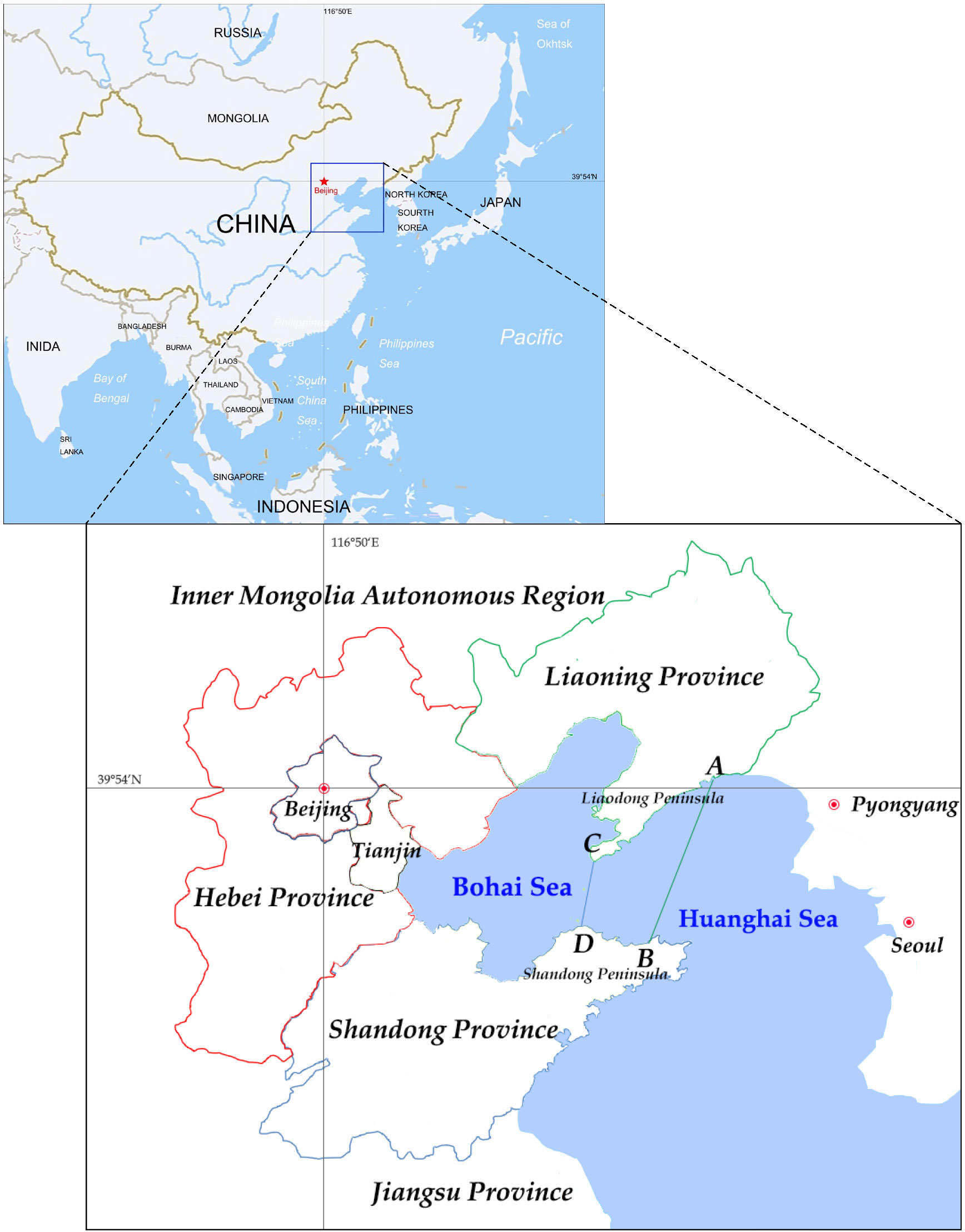
Figure 1 Map showing areas of Bohai Sea Rim. Line CD is the natural boundary between the Bohai and the Huanghai Seas, but the Bohai Sea area in this study refers to the entire part west of Line AB. The line AB between the coastline junction of Dalian and Dandong on the Liaodong Peninsula and Yantai and Weihai on the Shandong Peninsula acts as the boundary, the sea region to the west, with an area of 95,000 km2, is the research area which includes the entire Bohai Sea and part of the Huanghai Sea (ABCD) adjacent to Dalian and Yantai.
2 Method and materials
2.1 Conceptual framework of the coordinated development based on SDG14
The essential elements of sustainable development theory are equality, sustainability, and commonality and its ultimate goal is to achieve common, coordinated, equitable, efficient, and multifaceted development (UN, 2016a; Ntona and Morgera, 2018). It stresses on integrating with long-term and holistic growth from a philosophical standpoint, requiring personnel, society, economy, nature, and culture to be addressed as one organism (UN, 2016a; UN, 2016b). According to this viewpoint, coastal region sustainability involves socioeconomic, and environmental coordination on land and coordinated development between land and water. As a result, the Coastal Economic Subsystem (CES), Coastal Social Subsystem (CSS), Marine Ecology and Environment Subsystem (MES, including the coastal component) must be jointly evaluated as their coordination and benign interaction is the only way to accomplish sustainable development of the coastal area. The three subsystems combine to form an organic development system: the CES-CSS-MES system (CESE). Economic development and social advancements result from resource utilization and allocation processes, and disruption to the ecology and environment is unavoidable. The CES is the driving force of CESE, the MES is the condition and limitation, and the CSS evolves based on CES and controls its direction of development, according to SDG. The CESE is being improved in tandem with the CES and CSS. However, when the CES is hindered by external factors or surpasses the carrying capacity of the MES, its rate of development will be sluggish or even regress. Consequently, the CSS directs the CES to implement adjustment, and CESE upgrading enters an adjustment period.
According to the coupling coordination theory, numerous systems or movements influence one another through various interactions and eventually combine to form an organism, performing specific functions and effects together (Wang et al., 2021). Here, the essence is the symbiotic interaction between systems and movement modalities. The system development process may be determined based on the coupling coordination degree and characteristics, and the system development state can then be elucidated. In this work, sustainable development theory and the coupled coordination model are integrated to establish a coupling system for sustainable development in coastal areas to characterize the interaction between subsystems and evaluate sustainable development.
The Bohai Sea management has verified the importance of coupling and coordination between subsystems in marine management. In the early stage of Reform and Opening-up, it experienced management centered on economic development; in the 2000s, ecological and environmental governance become the center, which began with the 2001 Blue Action Plan of Bohai Sea that emphasized the marine ecosystem, ignoring the coupling with the social and economic systems, which made the management encounter setbacks. Until the ecological civilization was proposed around 2012, the management of the Bohai Sea gradually moved towards the coupling and collaborative development of various subsystems and the ILSM. It has been recognized that the management of the Bohai Sea is inseparable from development and resource and environmental issues (Xue et al., 2023), i.e., resource exploitation, ecological and environmental issues, and socioeconomic development and are interrelated and mutually restricted. Therefore, the management of Bohai Sea is bound to be a process of coupling and coordination, and the isolated emphasis on the development of an individual system cannot achieve sustainable development. Only an integrated development can manage environmental issues without affecting socioeconomic development. The SDG14 emphasizes to “Conserve and sustainably use the oceans, seas and marine resources for sustainable development (UN, 2016a; UN, 2023).” The management of Bohai Sea is a coupling coordination system, which consists of three subsystems the ecological and environmental, economic and social subsystems, combined by ILSM. This system is consistent with the balance and coordination between subsystems emphasized by sustainable development (Un, 2012; Yan et al., 2018).
Figure 2 depicts the coupling system for sustainable development in coastal zones and the transition paths. Theoretically, sustainable development is a process of continuous coupling, coordination, and improvement of subsystems.
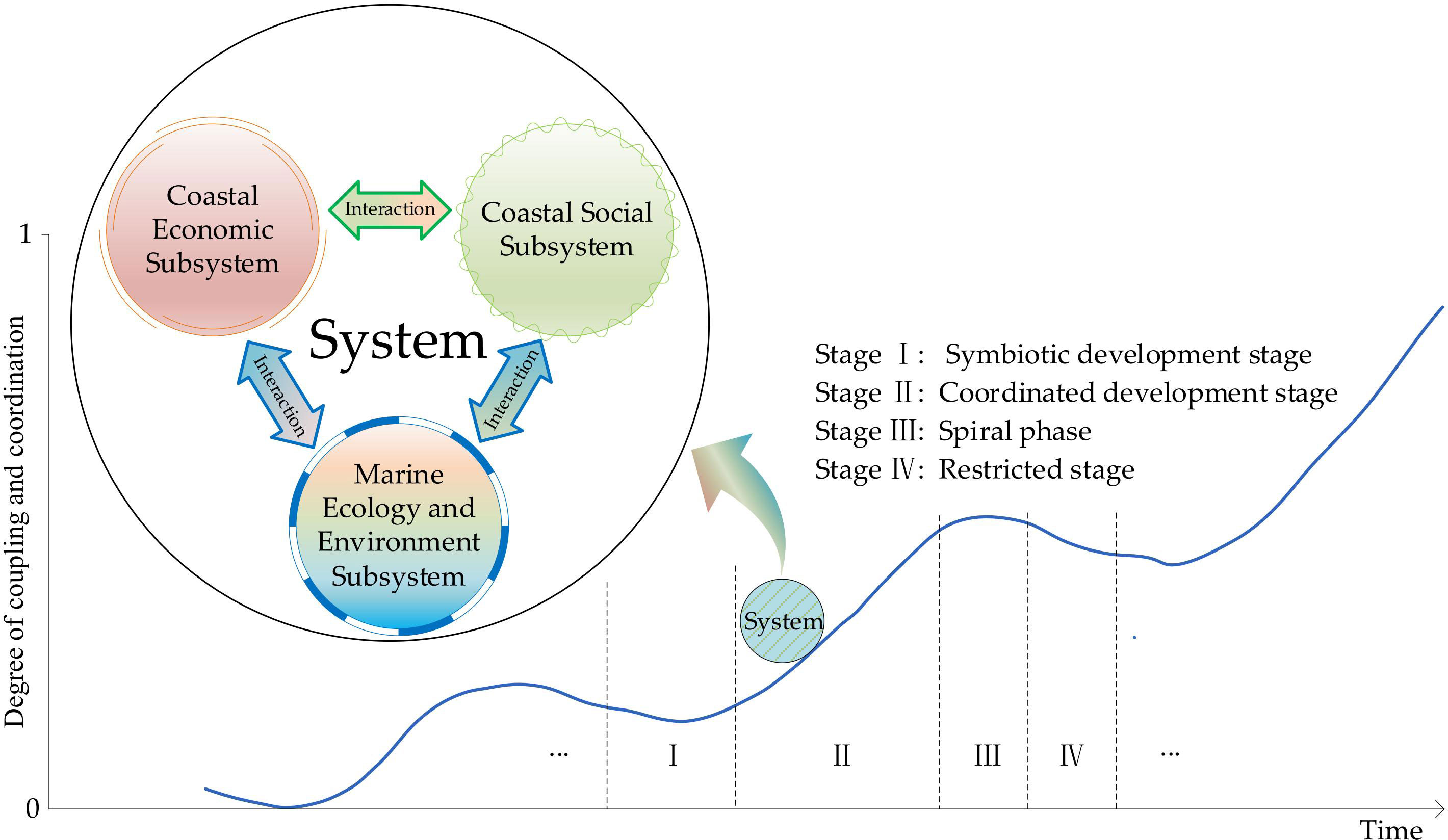
Figure 2 Coupling system for sustainable development in coastal areas.
The coupling transition paths of the CES, CSS, and MES are assumed to meet the S-type periodic fluctuation mechanism, and the development of the system exhibits periodic characteristics. Each cycle can be divided into four phases, stages I, II, III, and IV. vc and vd are the coupled and coordinated development velocities, respectively. The coupling and coordinated development of CESE system around coastal areas can then be expressed as follows:
Stage I is the symbiotic phase. After the previous recession stage, the CSS directs CES adjustment, development mode transformation, and industrial structure adjustment, reducing the dependence and interference on MES. As the CES enters the recovery period, the constraints and restrictions between subsystems are very weak and both vc and vd are small.
Stage II is the coordinated development phase. Economic recovery leads to the upgrading of CESE. Interference of the CES to the MES does not exceed its bearing capacity. The CES, CSS and MES work in harmony with each other. vc and vd increase.
Stage III is the spiral phase. The CES gradually places stress on the MES, which starts degrading resulting in the constraints on the CES and CSS, although this is not yet apparent. vc continues to increase, whilst vd gradually decreases.
Stage IV is the restricted development stage. The MES has an obvious restricting effect on the CES and CSS. The declining CES pushes the CESE into a downward channel. Both vc and vd decrease. Figure 2 shows the continual system evolution process in which the ability to achieve sustainable development is constantly improved.
2.2 Index system of sustainable development for evaluation
The marine ecosystem considered in this study involves the marine zone, coastal zone and the coastal economic belt, and the delta region as well. Similarly, the economic subsystem involves the development of marine and coastal zone economies. The social subsystem includes the development of coastal towns, but also the development of coastal cities and coastal provinces in a larger scale. Each subsystem is based on the integration of land and sea. However, there is no data for the Bohai Rim in the actual government statistics, so we must adapt the index system, rather than directly use the indicators of land and sea integration. The construction of the index system considers both marine and coastal land indexes as much as possible, which enables to better integration of sea and land for systematic coupling research.
A CESE-based index system was established to evaluate and measure the sustainable development of the Bohai Rim region, where, the CES reflected the economic, industrial structure, and production efficiencies; the CSS reflected the construction of public facilities, the lives of residents, and social services; and the MES reflected the marine and coastal ecology, environment, and resources. Table 1 displays the index system and its three components: the Bohai Region, the provincial, and the city index systems.

Table 1 Index systems of sustainable development (Bohai Region, Province, and City).
2.3 Data
This study used the time series data of the Bohai rim region, four coastal provinces, and 13 coastal cities, which were obtained from the China Coastal Sea Environment Quality Bulletin, China Marine Ecological Environment Bulletin, China Marine Disaster Bulletin, China Statistical Yearbook, China Marine Statistical Yearbook, Statistical Yearbooks and Government Statistical Bulletins of relevant provinces from 2006 to 2021, and Statistical Yearbooks and Government Statistical Bulletins of the 13 cities from 2018 to 2021.
It should be noted that the south coastline of Yantai belongs to the Huanghai Sea, and is outside the study area. However, government data do not distinguish between the parts belonging to the Huanghai and Bohai Seas. The entire southern coastline is located in Haiyang County whose GDP and population County account for about ~5% and ~8% of those of the Yantai City, respectively. With respect to ecological and environmental integrity, the coastline length of this part accounts for ~19% of that of Yantai City.In addition, Yantai City has seven rivers that drain into the sea, forming deltas with a combined area of more than 300 km2, of which only one river flows into the southern Huanghai Sea (Wulong River), and the other six all flow into the Bohai Sea (Dagu River, Dagu Jiahe River, Wang River, Jie River, Huangshui River and Xin ‘an River). The Wulong River originates in Laiyang County and flows into the Huanghai Sea in Haiyang County, and the basin is present in the two counties. The total GDP and resident population of Haiyang and Laiyang account for about 10% and 19% of that of Yantai, while the other indicators were still relatively small. This suggests that the Bohai coast is at the center of the socioeconomic development and ecological environment management of Yantai. We used the statistical data of Yantai as the ILSM data of the Bohai Sea, which may cause some deviation from the actual results; however, the deviation was not very large, and the empirical results reported in this study also show that it is acceptable.
2.4 Mathematical method
2.4.1 Data standardization and Index weight
2.4.1.1 Data standardization
The raw data was standardized by Linear Normalization (Max-Min) to eliminate the influence of dimension and magnitude:
Positive indicator: (1)
Negative indicator: (2)
where is the raw data and represent the standardized values.
2.4.1.2 Index weight
Determining index weight is a critical step before proceeding to the formal model. To ensure the objectivity of each index weight in the index system, we selected the entropy method to determine the index weight. Here, the model was not introduced in detail. The index weight was determined by the SPSS package.
2.4.1.3 Comprehensive evaluation value
The linear weighting model is a multi-index comprehensive evaluation model that evaluates the object by linearly weighing multiple indexes.
where Up is the comprehensive evaluation value of subsystem p, k is the number of indicators in subsystem p, and is the weight of indicator j, .
2.4.2 Coupling coordination degree model
Coupling, originally a physical term, is widely used to understand the relationships among multiple systems. It is often used to study the interaction and interdependent coordination relationship among society, economy, environment, and energy (Lu et al., 2017; Gai et al., 2018; Li et al., 2019). Coupling degree (C) refers to the interaction between two or more systems to realize the dynamic relationship of coordinated development. It reflects the degree of interdependence and mutual restriction between systems (Wang et al., 2021). The coupling effect and degree of coordination determine the order and structure of the system when it reaches the critical region, i.e., the trend of the system from disorder to order. The coordination development degree (D) refers to the degree of benign coupling in the coupling relationship and reflects coordination quality. The coupling coordination model often used in the existing literature is as follows:
where n is the number of subsystems, C is the Coupling Degree. C∈[0,1], wherein values closer to 1 denotes a smaller degree of dispersion between subsystems and better coupling. However, it also denotes a lower C between subsystems. The interpretation of C depends on the interval distribution of its value.
However, when equation (4) is employed to construct binary and ternary systems, the distribution probability of C in the interval [0, 1] is not uniform, and the large probability is biased to 1, implying a generally high C. Furthermore, large proportional differences across the systems rarely occur when applied in social sciences, and C are concentrated above 0.7 in most empirical research (Wang et al., 2021). This may lead to inaccurate interpretation, and the slight differences of Cs are insufficient for comparing different systems.
The C and D achieved by the model is relative, which are the advantages and disadvantages between the comparing objects (systems). Therefore, to improve the explanatory validity and reliability, equation (4) was adjusted so that C appears in [0, 1] uniformly, resulting in the modified model, equation (5).
where αp is the weight of subsystem p, , and T is the comprehensive evaluation score of the object (system). Equation (7) is the coordination development degree of the system, with D∈[0,1], where a value closer to 1 denotes better coordination.
Several previous studies have discussed the classification criteria for C and D. Table 2 shows the classification criteria adopted in this study.
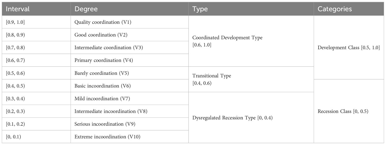
Table 2 Classification criteria for coupling degree and coordination development degree.
3 Results
3.1 Sustainable development of the CESE system in the Bohai Rim region
The CESE system of the Bohai Rim coastal (Tianjin, Shandong, Liaoning, and Hebei) and the Bohai Sea areas, encompassing the MES, CSS, and CES subsystems, was based on the sustainable development and coupling collaborative theory. The coupling and collaborative development analysis were conducted using equations (5), (6), and (7). Figure 3 shows the results of CESE of the Bohai Rim region.
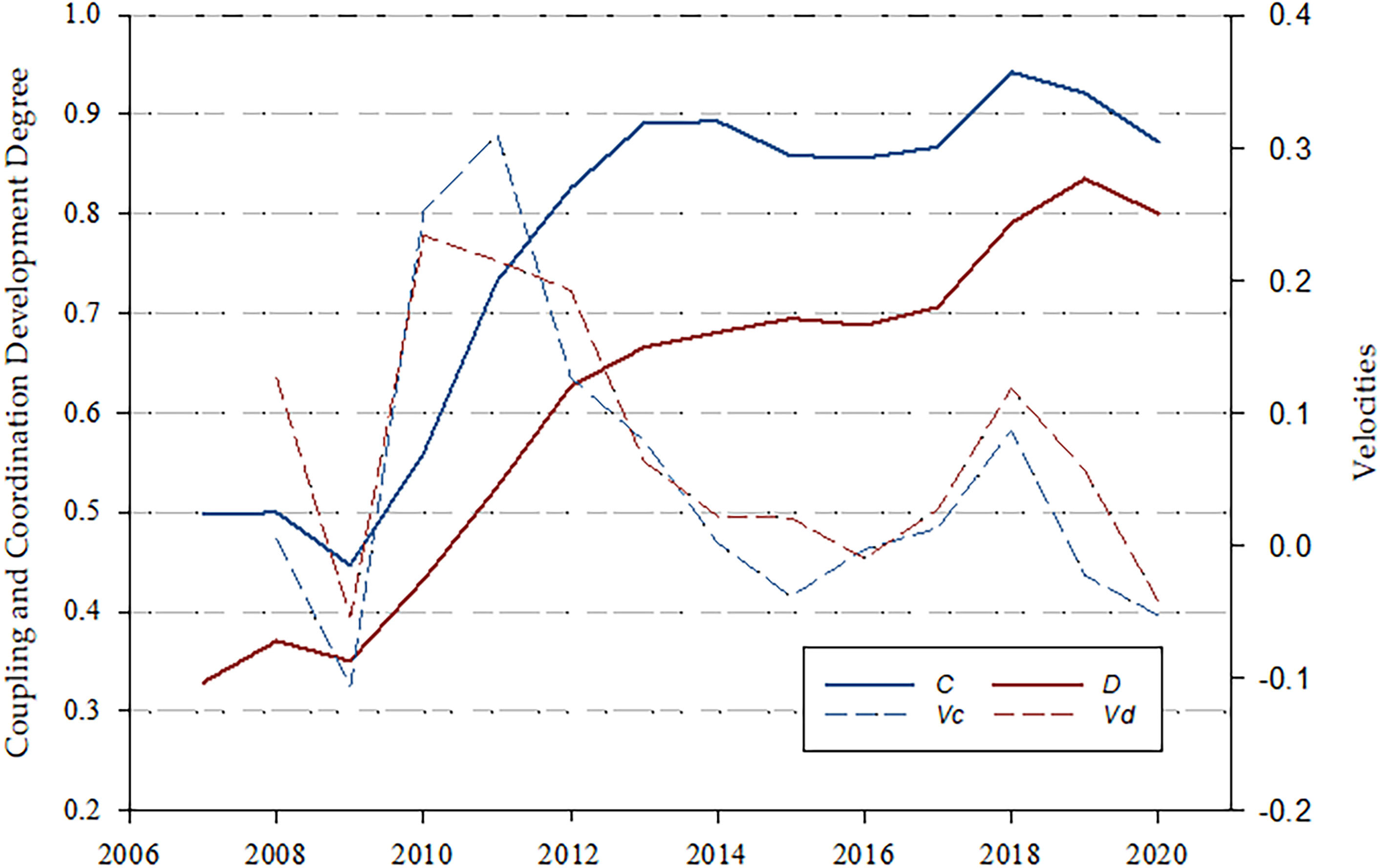
Figure 3 Transition of the CESE System in the Bohai Rim (2007–2020). C is Coupling Degree and D is Coordination Development Degree. , .
The transition of the CESE system is very similar to the coupling system inferred in the theoretical framework (Figure 2), both of which involve development from low to high level, wherein the spiral rises continuously. This proves the reliability of the proposed theoretical framework. The transition of C and D presents an S-shaped state of rising fluctuation, similar to the theoretical transition trajectory of regional coordinated, sustainable development (Figure 3). The rapidly increasing trend of C and D before 2013 corresponds to Stage II (Figure 2) in the transition cycle. As both vc and vd enter the downward channel from 2011 to 2015, the fluctuations after 2014 may represent Stage III or the beginning of Stage IV.
From 2007 to 2020, C was in the range of (0.4, 1.0), showing an overall rising trend. It increased rapidly before 2013 but showed slow growth with fluctuations from 2013 to 2020. With respect to the classification criteria of coupling coordination degree (Table 2), C changed from Recession Class to Development Class (V6 to V1), and entered into the range of (0.8, 1.0) after 2012. The peak, 0.921, appeared in 2018, reaching Quality Coordination (V1). D was in the range of (0.3, 0.8), with an upward trend similar to C over the past 14 years. The lowest degree, 0.329, was in the Dysregulated Recession Type, which hovered at the Mild incoordination (V7) level until 2010. In 2012, it first surpassed 0.6, entering the Coordinated Development Type and gradually exceeded 0.8 after 2018, to the Good coordination (V2) degree, and peaked at 0.835 in 2019.
3.2 Sustainable development of CESE system in coastal provinces
3.2.1 Trends in the coastal provinces
The CESE system and three subsystems for every coastal province between 2006 and 2020 were constructed. Provincial variation trends of C and D are shown in Figure 4. The C and D of different years in the same province were comparable, but the differences between them could not be compared horizontally.
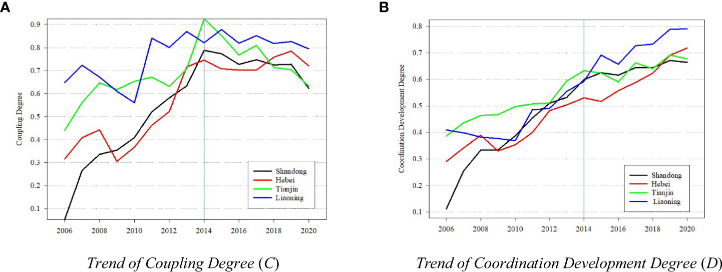
Figure 4 Transition of the CESE System in the coastal province (2006–2020).
The C of the four provinces showed an upward trend (Figure 4A). Before 2014, the C increased rapidly and fluctuated greatly, while after 2014, it mostly adjusted with little fluctuation. Shandong and Hebei saw the largest increase in the past 15 years, reflecting the drastic socioeconomic, ecological, and environmental changes. Shandong increased from below<0.1 to ~0.8, transforming from Recession Class to Development Class and hovering at 0.7 after 2014, around Primary coordination (V4) and Barely coordination (V5). The situation in Hebei was the same as that in Shandong, but the amplitude of change was slightly different. The changes were minimal in Tianjin and Liaoning, always remaining in the Development Class. Separately, Tianjin increased from<0.5 to >0.9, from Basic incoordination (V6) to Quality coordination (V1) degree, but fell quickly after 2014. While Liaoning showed the smallest overall change among the four provinces over the past 15 years, it remained within the range (0.8, 0.9) after 2011. This situation does not suggest a high level of sustainable development, because the constructed model is of a relative degree. The situation of Liaoning could only show that its CESE system has mostly remained the same in recent years and at the same level since 2011.
The D of the four provinces showed an overall upward trend (Figure 4B), without an obvious turning point. Only the growth rate of D in Shandong slowed down slightly after 2015, but still maintained a rising trend. This may indicate that changes in the trajectory of regional sustainable development have no basis, i.e., the signs of the change from growth Stage II to development Stage III or IV shown by the combination of vc and vd may be vague and cannot be fully concluded and vc and vd do not become deterministically negative from 2014 to 2020 (The occasional negative does not mean a deterministic trend).
3.2.2 Horizontal comparison of the same year among coastal provinces
A cross-section model was constructed to study the differences among the coastal provinces. Table 3 shows the model results of representative years. These results can only be compared with the same year, rather than time series analysis.
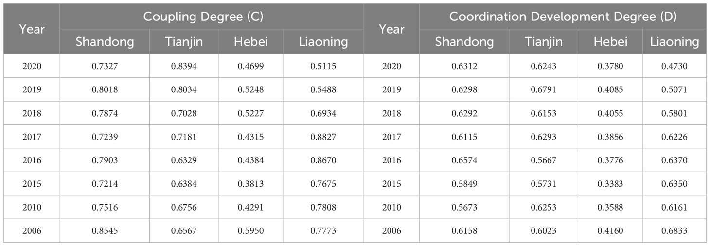
Table 3 Coupling coordination degree comparison of four provinces around the Bohai Sea in representative years.
The relative positions reflected by the C and D of the coastal areas around the Bohai Sea have changed significantly in the past 15 years, but Hebei, which has been in the lowest position with the least changes, contrasts other provinces. From 2006 to 2017, the C of Liaoning fell in the Intermediate coordinate (V3) or Good coordination (V2) degree and D was consistently >0.6 at the Primary coordination (V4) degree. After 2017, it was successively surpassed by Shandong and Tianjin, and its C and D gradually lagged. Since 2018, the two degrees of Shandong and Tianjin remained the same, but Tianjin was slightly better than Shandong. The Cs of Tianjin and Shandong were in the (0.7, 0.9) range, Intermediate coordinate (V3) and Good coordination (V2), while the Ds were in the (0.6, 0.7) range, Primary coordination (V4), occupying the original position of Liaoning.
3.3 Sustainable development of CESE system in coastal cities
To analyze the reasons of sustainable development in the Bohai Rim region, the study area should be refined. The city was considered as the unit to build the CESE system for model analysis using sectional data from 2018– 2020. Results of the three years were averaged as the C and D of each city. Figure 5 shows the model results of the 13 cities around the Bohai Sea.
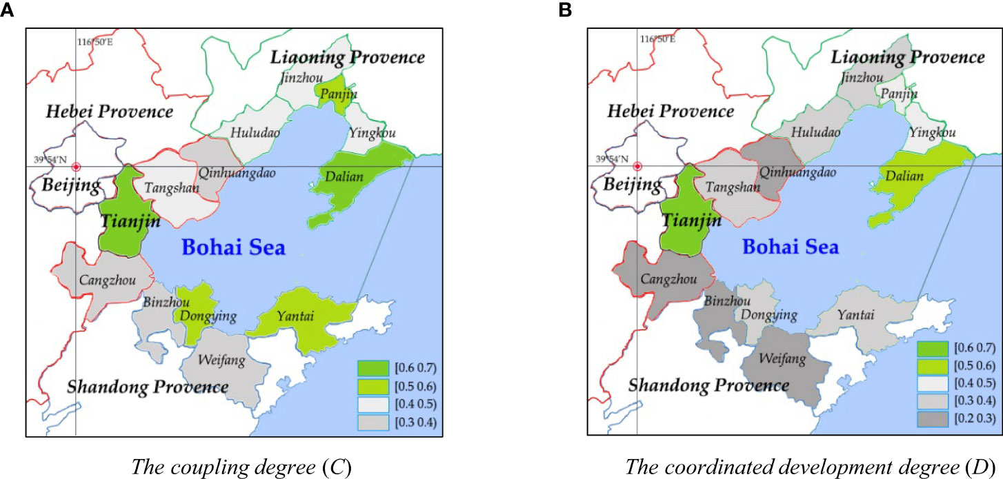
Figure 5 Coupling and coordinated development degree of the coastal cities. C and D are the mean values of the three model results (2018– 2020).
The Cs and Ds of the 13 cities around the Bohai Sea were highly consistent. Among the 13 cities, Tianjin and Dalian had the highest economic development, complete industrialization, relatively complete education, medical care, and social security. Meanwhile, these cities significantly regulated and supervised the marine ecology and environment to continuously reduce pollution and ecological disturbance during development. Therefore, a positive relationship was observed between the Cs and Ds among subsystems of the CESE system in Dalian and Tianjin.
Some cities had varying degrees of coupling and coordination. For example, the Cs of Dongying and Yantai fell in (0.5, 0.6), Barely coordination (V5), but the Ds fell in (0.3, 0.4), Mild incoordination (V7). The economic development of the two cities was highly dependent on resources, and the non-ferrous metal smelting, rubber, and petrochemical industries dominated for a long time. The relationship between subsystems was strong, but due to the lack of benign interaction, economic growth doubled the pressure on ecology, environment, and resources. This affected the industrial structure adjustment and transformation of the two cities according to their status quo and the promotion of the transformation of old and new drivers to improve the sustainability of systems.
Cities with low Cs and Ds, such as Weifang, Binzhou, Cangzhou, and Qinhuangdao, mostly fell in the Recession Class (0, 0.5; Figure 5), such as Weifang, Binzhou, Cangzhou and Qinhuangdao, the majority of which started late in economic growth, particularly the backward marine industries. Therefore, they had less interaction and coordination between the CES, CSS, and MES compared with other cities, leading smaller Cs and Ds.
4 Discussion
The theoretical framework of CESE was first constructed by combining sustainable development and coupling coordination theories. Taking the Bohai Sea Rim as an example, this study combined the land and sea to study the relationship between the coastal economic, social, and marine ecosystems with respect to sustainable development. Adaptive government policies were believed to promote regional sustainable development processes.
4.1 Transition trajectories and development trends of the CESE in the Bohai Rim region
The empirical results revealed that the trajectory of C and D had an S-shaped fluctuating growth trend in terms of time in both the Bohai Rim region and coastal provinces. This was consistent with the theoretical framework established in Section 3.1. A new round of high-level coupling and coordinated development was conducted after experiencing retardation or profound adjustment, characterized as a process of first decline and then growth (Lu et al., 2017; Li et al., 2019). The CESE model of the Bohai Rim region showed that both the C and D values experienced a correction in 2009 and continued to increase until 2014, when it once again entered into adjustment. The Cs of the four province models also showed the same rule. Moreover, C and D were highly consistent, simultaneously being high or low. For example, Dalian and Tianjin were both high, while Binzhou and Cangzhou were both low. Theoretically, the benign interaction between subsystems can be considered a systematic relationship and the strength of the benign effect can reflect the strength of the interactive relationship to some extent (Lu et al., 2017; Wang et al., 2021); therefore, a consistent change law between C and D exists. However, the benign relationship is not the entirety of the interactive relationship; hence, the change between C and D is not synchronous, and they experience some variation. In the Bohai Rim model, D changed slowly and lagged behind C. The relationship between subsystems is the premise of a benign relationship, which is why C changes before D (Lu et al., 2017).
The results also show that system transition I was closely related to the economic situation. Compared with D, C was closely related to CES. Modeling results of the Bohai Rim region and coastal provinces showed that the transition path of the system turned to different degrees in 2009 and 2014. Development of the Bohai Rim region was affected by the global financial storm caused by the U.S. subprime debt crisis in 2009 (Lo, 2010) and it entered the economic soft-landing period with changes in the economic situation of China after 2014 (Pei, 2016). Sino-US Trade Conflicts from 2018 and COVID-19 from 2019 further constrained and shocked the regional economy (Liu and Woo, 2018; Dhar, 2020; Han, 2022; Yan J. et al., 2022),with C and D showing the same character as the economy. They increased rapidly during economic growth but decreased and fluctuated sharply during economic difficulties and recessions. D would not change proportionally with the decrease of C (Figure 4B). This indicates that the benign interaction relationship can exist in reverse when the relationship of the entire system weakens. Since 2018, the Bohai Sea Eco-Environmental Governance Action Plan has aimed to reverse the increasingly bad marine eco-environment situation and reduce the pressure of socioeconomic development on the ecology and environment (MEE et al., 2018). The artificially forced transformation of the development mode during the decline of economic growth caused inconsistencies in the change tracks of C and D.
4.2 Regional differences in coupling coordination
With respect to regional differentiation, the gap between relative C and D changed constantly. C and D in the developed provinces and cities of the marine economy were stronger than those in the backward areas. In the past 15 years, the relative positions of provinces have changed significantly, especially Liaoning, Tianjin, and Shandong. Before 2018, the C and D of the CESE system in the Liaoning province were relatively high, i.e., it was in a relatively advantageous position in each year, indicating a sustainable relation between economic development and the environment, which is similar to the studies of (Yang and Sun, 2014). However, the recent economic transformation speed of Liaoning has been relatively slower than that of Shandong and Tianjin (Jiao, 2018; zhang, 2020; Li et al., 2021), resulting in the gradual lag of C and D from the highest relative position. Since 2012, the population has had a continuous outflow, especially senior human capital (Deng and Zhang, 2022). The lack of innovation capacity within the region and the constraints of the heavy industry base have increased the difficulty of transformation (Chunjuan et al., 2021). Meanwhile, Shandong and Tianjin have continuously contributed to the marine economy in recent years, forming a multi-faceted marine development and utilization planning system from the province to the city and then to the county levels, covering the fields of economy, society, marine resources, ecology, and environment (ShandongGovernent, 2022). It has attracted numerous technologically advanced industries and talents, changing the relative positions of coastal provinces, i.e., optimizing the coastal industrial layout played significant and positive roles in promoting the overall development of land and sea. As for Hebei, with respect to time series, its C and D have been improving rapidly, but among the four provinces, they are at the bottom state. Although Hebei has paid more attention to the marine and coastal areas in recent years, the positive land–sea interaction reflected by the relationship between the three subsystems is still in the primary stage and behind other provinces due to its weak industrial base and unreasonable industrial structure in the coastal areas. It has yet to form a coastal and marine economic system along with an interrelationships between the subsystems; hence, the C and D of Hebei are relatively low.
City models displayed an apparent polarizing phenomenon; cities with better socioeconomic development had consistent Cs and Ds, while others were at comparatively lower levels. Through careful study and comparison, we observed that this was consistent with reality. Tianjin and Dalian are the most economically developed, mature, and active megacities. These two cities started early and have sound and reasonable industrial structures (Gai et al., 2018). Moreover, they have always been the earliest adopters of China’s most cutting-edge concepts and systems, such as circular economy, low-carbon economy, digital economy, and marine ecological civilization (Sun et al., 2018; Lu, 2020). Geographical and policy advantages promote this prominence. Theoretically, the city agglomerations are hierarchical and gradient, with the central city driving the development of surrounding cities and producing a siphoning effect. The surrounding cities are restricted by the development of central and regional core cities. Factors such as capital, technology, industry, and human resources flow to the central cities with better basic conditions, limiting the surrounding cities (Ma and Wu, 2022). Therefore, Tianjin and Dalian secured higher C and D values.
4.3 Connections across spatial levels
The Cs exhibited S-shaped characteristics in the Bohai Rim region and provincial models, while the Ds showed S-shaped and linear characteristics. Although the results drawn from different models are not comparable, the models in this study that were built on the same theoretical basis and similar index systems also have the significance of mutual reference. Identical S-types of C could be easily explained by theoretical models and practice. After careful analysis, the consistency of the two phenomena were mutually verified, except for the specific details of the difference. Despite the S-shape, the D in the region model always increases, indicated by the positive vd, consistent with the provincial models. The difference in specific shapes may be due to subtle differences between indicator systems (Lu et al., 2017). Therefore, we were able to find the direction to promote the sustainable development of the sea area from the provinces because this spatial contrast clarified that the sustainable development of the Bohai Rim is closely related to the provinces and cities, making our detailed study of provinces and cities more meaningful.
The results also showed no consistency in the C between provinces and coastal cities. In the model after 2018, the Cs and Ds of Shandong and Tianjin were higher than those of Liaoning, but the C and D of the coastal cities in Liaoning were generally higher than those of the cities in Shandong owing to the difference in geographical advantage of these cities in their provinces, i.e., the extent to which coastal cities can represent the situation of their provinces is different. Apart from Shenyang, most of the economy and population of Liaoning are concentrated in five coastal cities: Dalian, Panjin, Jinzhou, Yingkou, and Huludao. As the centers of city agglomerations, Qingdao and Jinan are the socioeconomic centers of Shandong compared to Yantai, Weifang, Dongying, and Binzhou (Wu et al., 2022); therefore, these four cities cannot represent the situation in Shandong, but rather their relative position among the 13 cities. Therefore, a contradiction between city and provincial Cs (and Ds) is nonexistent. However, coastal cities in Shandong have a larger development space because the southern coast of the Bohai Sea does not have a strong coastal city cluster. Here, Yantai and Weifang showed high potential based on the D value.
5 Conclusion
Realizing sustainable development is a spiral process of subsystem interaction. This work proposes a theoretical model and empirically demonstrates this mechanism. The policies that promote economic growth accelerate the transition of sustainable development system, while in the economic downturn, the adaptive environmental policies promote the coordination of regional systems by adjusting the relationship between subsystems to prepare for the transition of sustainable system in the next stage of economic recovery. In this study, the theory of sustainable development was combined with the coupling model to establish a theoretical development model, which showed the internal structure of the regional sustainable development trajectory. The proposed model was used to study the sustainable development of the Bohai Sea from three perspectives: sea area, coastal provinces and cities, which is the focus of SDG14, to provide a reference for the management of sea areas in the world, especially the Gulf governance. The C and D of the CESE system in the Bohai Rim region gradually improved through fluctuations. The economy is critical to the process of sustainable development. When it is in recession, the system enters the adjustment period, and once the economy recovers, the coupling of the system demonstrates overstep growth. Positive interaction between society, economy, marine ecology, and environment in the Bohai Rim was gradually established, and the regional sustainable development ability was constantly enhanced. During the economic recession, the ecological and environmental policies of China around the Bohai Sea have steadily become more effective, reflected by the relative position changes between provinces and cities. However, heterogeneity in the coupling coordination between some cities and provinces should also be acknowledged. Economic transformation and structural adjustments of coastal cities should further improve the marine economic system, fully utilize coastal location advantages, and promote industrial and population agglomeration in coastal areas for social progress while reducing damage and reliance on the marine ecological environment. This could be the next area for development.
The theoretical model constructed in this study describes the transition path of regional sustainable development; however, the conclusion derived by the mathematical model based on the coupled coordination model yielded closed results, limiting the comparability of model construction in different cases. This aspect can be addressed in of future studies.
Data availability statement
The original contributions presented in the study are included in the article/supplementary material, further inquiries can be directed to the corresponding author/s.
Author contributions
Conceptualization: JY and YX. Data curation, Formal analysis and Investigation: JY and DL. Methodology, Software and Roles/Writing - original draft: YX. Funding acquisition, Project administration and Supervision: JY. Writing - review & editing: YX, HW and MM. Resources, Validation and Visualization: JY and HW. All authors contributed to the article and approved the submitted version.
Funding
This research was funded by National Philosophy and Social Science Foundation of China, grant number 19CJY023.
Conflict of interest
The authors declare that the research was conducted in the absence of any commercial or financial relationships that could be construed as a potential conflict of interest.
Publisher’s note
All claims expressed in this article are solely those of the authors and do not necessarily represent those of their affiliated organizations, or those of the publisher, the editors and the reviewers. Any product that may be evaluated in this article, or claim that may be made by its manufacturer, is not guaranteed or endorsed by the publisher.
References
Álvarez-Romero J. G., Pressey R. L., Ban N. C., Vance-Borland K., Willer C., Klein C. J., et al. (2011). Integrated land-sea conservation planning: the missing links. Annu. Rev. Ecol. Evol. System. 42 (1), 381–409. doi: 10.1146/annurev-ecolsys-102209-144702
Chunjuan W., Qi W., Dahai L., Xiqian W. (2021). Co-integration analysis on China marine science and technology innovation, transformation and upgrading of marine industrial structure and marine economic development based on ARDL model. Sci. Technol. Manage. Res. 42 (24), 136–142.
CPC S. C. (2015) Overall plan of ecological civilization system reform. Available at: http://www.gov.cn/guowuyuan/2015-09/21/content_2936327.htm (Accessed 12 March 2022).
Cunningham A. (2019). Adaptive management strategies on the Chesapeake Bay regarding TMDLs. (Delaware, United States: University of Delaware).
Deng Z.-l., Zhang J.-w. (2022). Population mobility and regional coordinated development under the background of domestic circulation. Econ. Rev. J. (10), 54–64. doi:10.16528/j.cnki.22-1054/f.202210054
Gai M., Nie C., Ke L. (2018). Carrying capacity and coordinated development of ERE system in the coastal area of Bohai sea. Econ. Geogr. 38 (7), 163–172. doi: 10.15957/j.cnki.jjdl.2018.07.020
Gao X., Zhou F., Chen C. T. (2014). Pollution status of the Bohai Sea: an overview of the environmental quality assessment related trace metals. Environ. Int. 62, 12–30. doi: 10.1016/j.envint.2013.09.019
Han Y. (2022). The impact of the COVID-19 pandemic on China's economic structure: An input-output approach. Struct. Chang. Econ. Dyn. 63, 181–195. doi: 10.1016/j.strueco.2022.09.014
Jiao L. (2018). Study on green growth efficiency measurement of coastal cities in china. (Dalian, China: Dalian University of Technology).
Kies F., Manuel M., De Los Rios P., Elegbede I., Corselli C. (2020). Integrated coastal zone management (ICZM) framework and ecosystem approach: eutrophication phenomenon at the mediterranean sea. Bulletin de la Société Royale des Sciences de Liége. 89, 55–73. doi: 10.25518/0037-9565.9493
Li Z. (2019). Development research on marine guangdong-hong kong-macau greater bay area. (Shenyang, China: Liaoning University).
Li X.-S., Long X.-X., Qi X.-X. (2019). Dynamic evolution and analysis of coupling development of economy. Soc. Environ. Yangtze River Econ. Belt Resour. Environ. Yangtze Basin 28 (3), 505–516.
Li L., Zhang P., Wang C., Cheng Y. (2021). Economic transformation process of old industrial bases from the perspective of regional economic resilience: a case study of Liaoning Province. Sci. Geogr. Sin. 41 (10), 1742–1750. doi: 10.13249/j.cnki.sgs.2021.10.006
Liu T., Woo W. T. (2018). Understanding the US-China trade war. China Econ. J. 11 (3), 319–340. doi: 10.1080/17538963.2018.1516256
Lo C. (2010). China after the subprime crisis: Opportunities in the new economic landscape. (London: Palgrave Macmillan).
Long R. D., Charles A., Stephenson R. L. (2015). Key principles of marine ecosystem-based management. Mar. Policy 57, 53–60. doi: 10.1016/j.marpol.2015.01.013
Lu H. (2020). Thoughts on accelerating the advancement construction of Dalian ocean center city in the new era. J. Shenyang Agric. Univ. (Social Sci. Edition) 22 (4), 430–435.
Lu J., Chang H., Wang Y. (2017). Dynamic evolution of China’s regional energy, economic and environmental coupling. Resour. Environ. China 2), 60–68.
Ma W.-B., Wu Y.-M. (2022). Does the construction of national central cities promote the innovation of urban agglomerations? Taking the nineteen urban agglomerations as an example. Stud. Sci. Sci. 52 (9), 55–71. doi: 10.16192/j.cnki.1003-2053.20220927.002
Mao Z., Xue X., Tian H., Michael A. U. (2019). How will China realize SDG 14 by 2030?— A case study of an institutional approach to achieve proper control of coastal water pollution. J. Environ. Manage 230, 53–62. doi: 10.1016/j.jenvman.2018.09.028
McLeod K., Leslie H. (2009). Ecosystem-Based Management for the Oceans (Washington, Covelo, London: Island Press).
MEE, NDRC, NDRC (2018) Action Plan for the Comprehensive Control of the Bohai Sea. Available at: http://www.gov.cn/xinwen/2018-12/12/content_5347888.htm (Accessed 01-01 2019).
Mega V. P. (2019). “Threatened urban and ocean biodiversity: the imperative of resilience,” in Eco-Responsible cities and the global ocean: Geostrategic shifts and the sustainability trilemma (Springer), 43–84.
Michel J. A. (2016). Rethinking the oceans: Towards the blue economy. (United States: Paragon House).
NDRC (2015) Outline for cooperation and Development in the Bohai Rim Region. Available at: http://www.gov.cn/zhengce/content/2015-09/27/content_10191.htm (Accessed 8 August 2021).
Ntona M., Morgera E. (2018). Connecting SDG 14 with the other Sustainable Development Goals through marine spatial planning. Mar. Policy 93, 214–222. doi: 10.1016/j.marpol.2017.06.020
Pei C. (2016). The logic support that China's economy will not "hard land". People's Forum 04), 54–56.
Pittman J., Armitage D. (2019). Network governance of land-sea social-ecological systems in the lesser antilles. Ecol. Econ. 157, 61–70. doi: 10.1016/j.ecolecon.2018.10.013
Ritter W. F. (2019). “Progress on the Chesapeake bay TMDL and challenges in meeting the 2025 pollution-reduction loads,” in World Environmental and Water Resources Congress 2019 (Pittsburgh, Pennsylvania: American Society of Civil Engineers).
Salomon M., Markus T. (2018). Handbook on marine environment protection: Science, impacts and sustainable management. (Switzerland: Springer).
ShandongGovernent (2022) Action plan for building a strong ocean province. Available at: http://www.shandong.gov.cn/art/2022/3/3/art_107860_117796.html?from=singlemessage (Accessed 10-1 2022).
Sheng G., Lin Z., Huihui S., Guangxi C., Wei L. (2020). Evaluation and driving force analysis of marine sustainable development based on the grey relational model and path analysis. J. Resour. Ecol. 11 (6), 570–579. doi: 10.5814/j.issn.1674-764x.2020.06.004
SOA (2017a) Guidelines on carrying out the pilot Work of the "Bay Chief System". Available at: http://www.gov.cn/xinwen/2017-09/14/content_5224996.htm (Accessed 17 August 2021).
SOA (2017b) Opinions on Further Strengthening the Work of Ecological and Environmental Protection in bohai Sea. Available at: http://zrzy.hebei.gov.cn/heb/gk/gsgg/tz/101495623864895.html (Accessed 21 June 2021).
Sullivan J. T., Berkoff T., Gronoff G., Knepp T., Pippin M., Allen D., et al. (2019). The ozone water–land environmental transition study: An innovative strategy for understanding Chesapeake Bay pollution events. B. Am. Meteorol. Soc. 100 (2), 291–306. doi: 10.1175/BAMS-D-18-0025.1
Sun J., Miao J., Mu H., Xu J., Zhai N. (2022). Sustainable development in marine economy: Assessing carrying capacity of Shandong province in China. Ocean. Coast. Manage. 216, 105981. doi: 10.1016/j.ocecoaman.2021.105981
Sun J., Qin W., Sun H., Li S., Du Y. (2018). Evaluation system and measurement of marine ecological civilization in coastal cities of China. Econ. Geogr. 38 (8), 19–28. doi: 10.15957/j.cnki.jjdl.2018.08.004
Techera E., Winter G. (2019). “Marine extremes: ocean safety,” in Marine Health and the Blue Economy (London and New York: Routledge).
UN (2012). The future we want. Available at: https://sustainabledevelopment.un.org/futurewewant.html. (Accessed March, 15th 2023).
UN (2016a) Sustainable Development Goals. Available at: https://sdgs.un.org/goals (Accessed March, 10th 2023).
UN (2016b). Transforming our world: The 2030 agenda for sustainable development. Available at: https://sdgs.un.org/2030agenda. (Accessed March, 15th 2023).
UN (2023) Global indicator framework for the Sustainable Development Goals and targets of the 2030 Agenda for Sustainable Development. Available at: https://unstats.un.org/sdgs/indicators (Accessed Jun, 11 2023).
Vince J. (2018). The twenty year anniversary of Australia’s Oceans Policy: achievements, challenges and lessons for the future. Aust. J. Marit. Ocean Aff. 10 (3), 182–194. doi: 10.1080/18366503.2018.1490882
Wang S., Dong Z., Zhang L. (2019). The implication, construction practice and promotion of Marine ecological civilization. Chin. Mar. Sociol. Res. 7), 101–114.
Wang S.-j., Kong W., Ren L., Zhe D.-d., Dai B.-t. (2021). Research on misuses and modification of coupling coordination degree model in China. J. Natural Resour. 36 (3), 793–810. doi: 10.31497/zrzyxb.20210319
Wilkin J., Rosenfeld L., Allen A., Baltes R., Baptista A., He R., et al. (2017). Advancing coastal ocean modelling, analysis, and prediction for the US Integrated Ocean Observing System. J. Operational Oceanogr. 10 (2), 115–126. doi: 10.1080/1755876X.2017.1322026
Winther J.-G., Dai M., Rist T., Hoel A. H., Li Y., Trice A., et al. (2020). Integrated ocean management for a sustainable ocean economy. Nat. Ecol. Evol. 4 (11), 1451–1458. doi: 10.1038/s41559-020-1259-6
Wu C., Wang D., Zhuang X. (2022). Spatiotemporal analysis of economy-resources-environment coupling coordination in the yellow river basin: A case study of Shandong metropolitan area. Ecol. Econ. 38 (12), 159–166.
Xue Y., Yan J., Li D., Zheng H. (2023). Integrated ocean management (IOM) for marine sustainable development goal (SDG)14: A case study of China’s Bohai sea. Sustainability 15 (7), 5979. doi: 10.3390/su15075979
Yan J., Han L., Xue Y. (2018). Restoration and management of marine ecosystem in China: A sustainable perspective of indicator evaluation. Indian J. Geo Mar. Sci. 47 (9), 1787–1793.
Yan J.-L., Xue Y.-J., Mohsin M. (2022). Accessing occupational health risks posed by fishermen based on fuzzy AHP and IPA methods: management and performance perspectives. Sustainability 14 (20), 13100. doi: 10.3390/su142013100
Yan J., Xue Y., Quan C., Wang B., Zhang Y. (2022). Oligopoly in grain production and consumption: an empirical study on soybean international trade in China. Econ. Res.-Ekon. Istraz. 36 (2), 2142818. doi: 10.1080/1331677X.2022.2142818
Yang Y., Sun C. (2014). Assessment of land-sea coordination in the Bohai sea ring area and spatial-temporal differences. Resour. Sci. 36 (4), 0691–0701.
Yang L., Wu L., Yan S. (2020). Market-based sea use management in China: Features and countermeasures. Mar. Policy 120, 104091. doi: 10.1016/j.marpol.2020.104091
Zhang J. (2020). Measurement of industrial green development efficiency in coastal cities of China. (Huainan, China: Anhui University of Science and Technology).
Approximate
Table A Indicators and Targets of SDG 14.
Keywords: sustainable development, marine ecosystems and environmental management, integrated land-sea management, SDG14, coupling coordination model, Bohai Sea
Citation: Yan J, Xue Y, Wu H, Li D and Mohsin M (2023) Evaluation of sustainable development of the Bohai Sea Rim based on integrated land–sea management: a multi-system coupling and coordination study at coastal, provincial, and city level. Front. Mar. Sci. 10:1235783. doi: 10.3389/fmars.2023.1235783
Received: 05 July 2023; Accepted: 15 September 2023;
Published: 10 November 2023.
Edited by:
Qicheng Meng, Ministry of Natural Resources, ChinaReviewed by:
Zhe Feng, China University of Geosciences, ChinaCaixia Wang, Chinese Academy of Sciences (CAS), China
Copyright © 2023 Yan, Xue, Wu, Li and Mohsin. This is an open-access article distributed under the terms of the Creative Commons Attribution License (CC BY). The use, distribution or reproduction in other forums is permitted, provided the original author(s) and the copyright owner(s) are credited and that the original publication in this journal is cited, in accordance with accepted academic practice. No use, distribution or reproduction is permitted which does not comply with these terms.
*Correspondence: Yongjie Xue, eHVleW9uZ2ppZUBzZHd1LmVkdS5jbg==