 Mafalda Marques Carapuço
 Tanya Mendes Silveira
 Zuzia Stroynowski
 Jorge Miguel Miranda
94% of researchers rate our articles as excellent or good
Learn more about the work of our research integrity team to safeguard the quality of each article we publish.
Find out more
PERSPECTIVE article
Front. Mar. Sci. , 01 March 2022
Sec. Ocean Observation
Volume 9 - 2022 | https://doi.org/10.3389/fmars.2022.849150
This article is part of the Research Topic Best Practices in Ocean Observing View all 84 articles
The Atlantic dimension of Portugal, with c. 1,700,000 km2 maritime area, led to the prioritization of the European Multidisciplinary Seafloor and water column Observatory - Portugal (EMSO-PT) in the national scientific infrastructures’ roadmap. In this work we present the EMSO-PT initiative: a research consortium joining 15 research institutions, with the aim of implementing a network of multidisciplinary underwater observatories in the Atlantic, as well as laboratories and data processing support infrastructures. EMSO-PT’s priority is to generate continuous scientific data on marine environmental processes related to the interaction between the geosphere, biosphere, and hydrosphere, and to develop new sensors and platforms which will extend ocean monitoring in the near future. Monitoring variables will include biotic and abiotic variables of the ocean floor and water column, namely temperature, salinity, turbidity, acoustics, currents, and dissolved oxygen. Data will be disseminated through European Multidisciplinary Seafloor and Water Column Observatory – European Research Infrastructure Consortiums (EMSO-ERIC) channels, allowing for the integration and open access of data acquired by all partners of EMSO-ERIC, and by the research community at large.
The ocean covers 71% of the Earth’s surface and drives global systems that make the Earth habitable for humankind. It provides food, materials, energy, and transportation. Weather, climate, and coastlines are ultimately linked to and regulated by the sea. Despite the worldwide recognition that the ocean provides life-sustaining services to society, human impacts are driving major changes on the ocean, which are putting liveability at risk. The minimization of anthropogenic impact requires ambitious levels of scientific evidence to support sustainable governance and management of human activities.
While there is a growing understanding of the importance of marine ecosystems for society and its intrinsic value (Selig et al., 2019), evidence shows that pressures from human activities on these ecosystems are increasing (e.g., Korpinen and Andersen, 2016; Lotze et al., 2018), putting the health of marine ecosystems at risk at a global scale (Borja et al., 2016). Ensuring a better understanding of the importance of the oceans, of human-ocean interactions and opportunities to act sustainably and reduce human impacts on marine ecosystem is of vital importance (e.g., Santoro et al., 2017; Barracosa et al., 2019; Borja et al., 2020). In particular, Blue Growth ambitions are becoming an important component of socio-economic development strategies (Eikeset et al., 2018). This can result in increasing pressures on marine and coastal ecosystems if this development is not designed and implemented with care. Thus, despite current regulatory framework, such as the Marine Strategy Framework Directive in Europe (European Commission, 2008) that was put in place to protect the marine ecosystem and biodiversity, it is likely that this challenging situation will continue into the future. Given the growing and seemingly limitless capacity to industrialize the oceans there is a need to reimagine how to effectively measure, monitor, and sustainably manage this 71 per cent of the Earth’s surface (Golden et al., 2017). The relevance of measuring and monitoring is increased due to the vast volume of the ocean which is neither fully observed nor adequately understood (Visbeck, 2018). This is widely acknowledged and targeted in the guidelines of the Framework for Ocean Observing, that provides a structure that allows ocean observing providers and users to engage in the ocean observation system at various points: from the inputs [e.g., essential ocean variables (EOVs)] to processes (observations and maintenance), to outputs (data and products) (Tanhua et al., 2019).
Due to the size, complexity and connectivity of the ocean, monitoring and data collection presupposes high investments, and nations need to cooperate to deliver the ambitious, costly science that is required to make informed decisions (Polejack et al., 2021). Sustained and systematic ocean observations are needed to document ocean change, initialize ocean system models, and provide critical information for improved understanding (Visbeck, 2018). This implies the use of ocean observatories, understood as collections of platforms capable of carrying sensors to sample the ocean over appropriate spatiotemporal scales (Liu et al., 2017). Furthermore, to effectively address the needs of scientific data and information in the development of socio-economic development strategies it is also necessary to acknowledge that the creation of products and services is not compatible with the approach that “one size fits all” and, therefore, differences in audiences require product development to be tailored to specific needs (Iwamoto et al., 2019). The needs of society (s.l.) must also be taken into consideration as a knowledge-based society is needed to meet the objective of sustainability (Carapuço et al., 2021).
In this work we present the European Multidisciplinary Seafloor and water column Observatory – Portugal (EMSO-PT) initiative. It is based on a research consortium joining 15 Portuguese institutions, with the main goal of implementing a network of multidisciplinary underwater observatories in the Iberian Margin. It includes operational organization, university based research groups and support laboratories for marine robotics and data processing. The funding from the Portuguese National Funding Agency and regional funds is close to nine million euros, ensuring not only the acquisition of the basic instruments for deep sea and water column monitoring, but also the re-equipment of complementary laboratories to support further development of the initiative.
The European Multidisciplinary Seafloor and Water Column Observatory – European Research Infrastructure Consortiums (EMSO-ERIC) is a distributed Research Infrastructure based on an integrated system of in situ Eulerian observatories. Its mission is the long-term observation of the deep seafloor and the water column by means of fixed-point multi-sensor platforms deployed in environmentally relevant sites of the European seas (Dañobeitia et al., 2020). A significant part of EMSO-ERIC services is provided through regional facilities. The Atlantic dimension of Portugal led to the prioritization of the EMSO-PT in the national scientific infrastructures’ roadmap. EMSO-PT is a European Large Scale Research Infrastructure, jointly funded by the Portuguese government and by the European Commission and corresponds to the Portuguese counterpart of the EMSO-ERIC.
The relevance of EMSO-PT data is particularly highlighted in view of Portugal’s maritime area which, including the Exclusive Economic Zones (EEZs) of the mainland and of the archipelagos of Madeira and the Azores totals c. 1,700,000 km2 (Ferreira et al., 2016). Portugal has the 5th largest EEZ within Europe and the 20th largest EEZ in the world. It’s 18 times more than Portugal continental area, and is still largely unknown and unexploited. This vast area will increase when the United Nations (UN) ratifies the submitted proposal to the Continental Shelf Extension, as provided under the UN Convention on the Law of the Sea, that aims to increase the maritime territory under the jurisdiction of coastal States. This increase in oceanic territory creates obligations toward fulfilling EU directives for the marine environment protection and conservation, an additional effort to obtain the necessary data as well as the capacity to efficiently exploit and transform it into knowledge.
Portuguese teams have participated in early EMSO initiatives, but their role was limited to the incorporation of seismic sensors and biological collectors. Instruments have been deployed in the two nodes in cooperation with Italy (in Iberia) and France (in Azores). EMSO-PT is structured as a national based integrated program joining technology and science, to develop leading edge instruments and techniques in line with the national and European priority to create the conditions for a sustainable exploration and exploitation of the deep platform. The consortium includes the main Portuguese research groups in the marine area, including robotics. Its composition, scope of activity and the role of each partner is described in Table 1.
Table 1. Members of EMSO-PT.
The main goal of EMSO-PT is to generate continuous scientific data on marine environmental processes related to the interaction between the geosphere, biosphere and hydrosphere. EMSO-PT will ensure the Iberian Margin node of EMSO-ERIC, through the installation of two underwater fixed-point observatories, one deep-site close to the former GEOSTAR - GEophysical and Oceanographic STation for Abyssal Research site (Miranda et al., 2015), and another shallower site in the Portuguese mainland northern coast (off the coast of Aguçadoura) (Figure 1). In each site an EGIM – EMSO Generic Instrument Module (Nadine et al., 2017) will be deployed in 2022. EGIM is a fixed mooring module with an instrument pack designed to continuously measure parameters of interest for most major science areas covered by EMSO-ERIC. It was designed and developed during the EU project EMSODEV – EMSO implementation and operation: DEVelopment of instrument module, with the objective to ensure accurate, consistent, comparable, regional scale, long-term measurements of ocean parameters (Garcia et al., 2017), which are key to addressing urgent societal and scientific challenges such as climate change, marine ecosystems and marine hazards. EGIM is to measure homogeneously a set of core variables using the same hardware, sensor references, qualification methods, data format and access, maintenance procedures in several European ocean locations as well as the same calibration methods (Pappalardo et al., 2015).
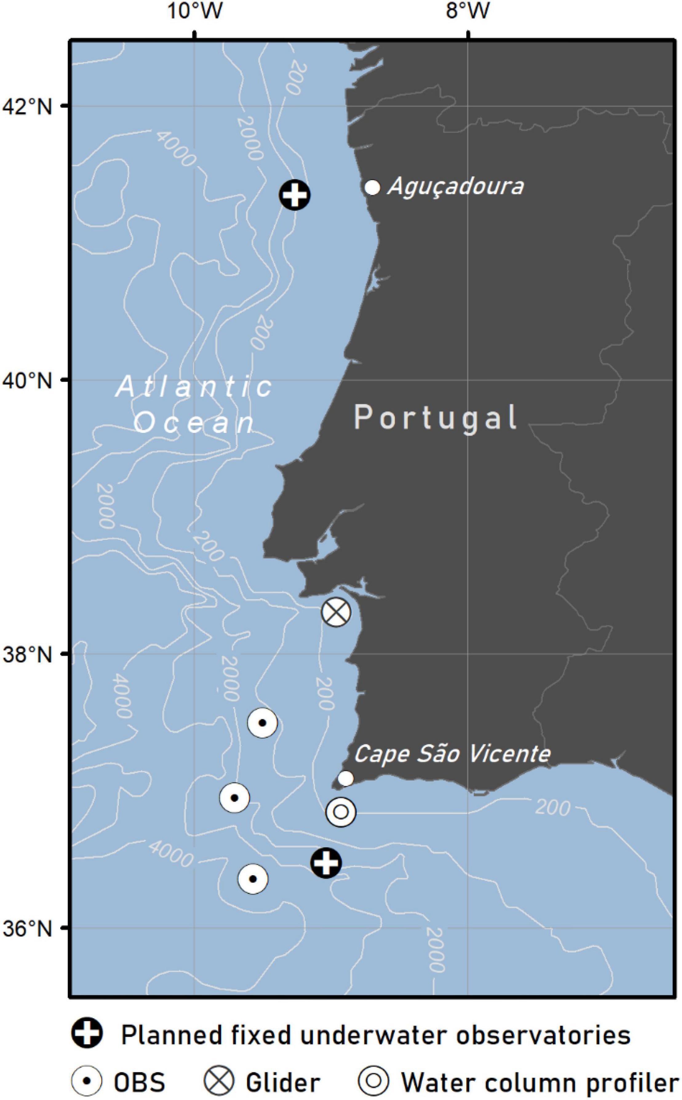
Figure 1. Planned location of the two fixed underwater observatories. Location of deployment of the water column profiler, ocean-bottom seismometers (OBSs), and test area of the glider in the scope of the EMSO-PT pilot oceanographic campaign.
The two observatories will include fixed deep sea moorings, planned to include a multisensory instrument package. The payload of each EGIM consists of a set of sensors targeting the measurement of temperature, dissolved O2, conductivity, pressure, turbidity, ocean currents and passive acoustics. A mix of other mobile and fixed ocean observation equipment will complement the EGIM data collection, along the water column (e.g., water column profiler) and ocean floor [e.g., ocean-bottom seismometer (OBS)].
EMSO-PT operation will follow the specifications defined by the appropriate EMSO-ERIC service groups. Fixed-point observations will be complemented by regular transects to be conducted by the gliders and/or autonomous underwater vehicles operated by the marine robotics research groups of the consortium.
In a first phase, data retrieval will be done at the time of equipment and sensors inspections and assessment of maintenance needs, planned to occur regularly at 6-months intervals. The maintenance and longevity of the observatory, as well as the data retrieval frequency will be assessed continuously and will be dependent on the evolution of the operation and identification of needs.
The Portuguese Institute for Sea and Atmosphere, I.P. (IPMA), which is both the Portuguese Meteorological, Seismological and Marine service, will disseminate all EMSO-PT data in the relevant national or international databases, through EMSO-ERIC channels and they will also be integrated in a new Ocean Atlantic platform in an effort led by IPMA, funded by the EEA Grants “Blue Growth” Program (Silveira et al., 2022).
EMSO-PT main national stakeholders are the R&D community, national administration entities related with ocean policy and governance and the economic sector.
Main R&D stakeholders are already in the partnership (Table 1). Their expectation is to support the monitoring of marine processes in the Iberian Margin as the basic information for their research (e.g., climate change, geo-hazards and geodynamics, deep sea biology, eutrophication. Micro-biological resources and adaptation of organisms to deep sea, ocean productivity, and non-renewable marine resources). The Portuguese marine robotics community are an important part of the initiative, as their role is not only to support monitoring observations but also to develop new approaches for long-term marine observation.
The two more relevant administration entities as stakeholders are the Directorate-General for Maritime Policy (DGPM) and the Directorate-General for Natural Resources, Safety, and Maritime Services (DGRM). DGPM mission it to develop, evaluate and update the National Strategy for the Sea, develop and propose the national policy of the sea, plan and organize the maritime space and monitor and participate in the development of the Integrated Maritime Policy of the European Union. DGRM mission is to develop maritime safety and services, including the maritime-port sector, the implementation of policies on fisheries, aquaculture, the processing industry and related activities, the preservation and knowledge of marine resources, as well as to ensure the regulation and control of activities in these areas. Both entities will benefit from EMSO-PT data to support the development of science-based policy and management of marine areas and uses.
Concerning the economic sector, the main stakeholders are the developers of near-shore aquaculture, fisheries and renewal, energy operators. Another area of major interest concerns deep sea mining where EMSO-PT will play a role, making available instruments and platforms for the definition of the biological and geological reference situation and the identification of any change of concern.
At the international scale, EMSO-PT stakeholders are those already identified by EMSO-ERIC as marine science researchers, marine technology engineers, resource managers, policymakers, marine industries and other ERICs (EMSO-ERIC, 2021).
EMSO-ERIC identified ten science-based services: climate change, marine ecosystem, geo-hazards, access to the infrastructure, training and best practices, technology and engineering, data management, communications and branding, lobby and policy, and international relations and partnering. EMSO-PT follows the established framework and aims to make available a subset of these services focusing on climate change, marine ecosystem and geo-hazards, which are considered the most relevant for the main national stakeholders.
EMSO-PT will be focusing on the Iberian Margin as it is one key area for the monitoring of climate change. It is characterized by wind-induced coastal upwelling controlling fisheries, the presence of Mediterranean outflow with implications on deep ocean circulation and it provides excellent sites to study the variations in the hydrologic cycle. Up to now, and despite the changes observed in the structure and spatial distribution of fish species with commercial value and the growing need for a better understanding of the changes in critical ecosystems, the only data available on the changes taking place in the Iberian waters are those acquired by satellite platforms (mostly addressing the ocean skin), the network of multiparametric buoys managed by the Hydrographic Institute, an agency of the Portuguese Navy, and short campaign data concerning the water column.
In terms of climate change and marine ecosystem services, the focus of EMSO-PT is currently particularly related with the monitoring of the EOVs in the Iberian Margin focusing on the Gulf of Cadiz and NE Atlantic, and also related with the application of the European Marine Strategy Framework Directive. Methodologies were already identified by the European Union project EMSO-Link.
EMSO-PT will ensure the Iberian Margin node of EMSO-ERIC, through the installation of two underwater fixed-point observatories: one located SW of Cape São Vicente (South of Portugal), in the Gulf of Cadiz, and another at a shallower depth, off the coast of Aguçadoura (North of Portugal) (Figure 1). The location of Cape São Vicente was chosen to investigate the Mediterranean outflow water as it enters the Atlantic, which is known to affect deep water circulation on a global scale. In addition, the geological and oceanographic features of this region favor the presence of highly diverse benthic communities and also play a central role in the dynamics of marine mammals. The area is also very important for geo-hazards. It is the site where one of the largest known earthquakes occurred in 1755, coupled with a destructive tsunami. The Cape São Vicente site is complemented by a fixed mooring consisting of a water column profiler and an acoustic doppler current profiler which will be deployed in 2022 following tests performed in 2021. Ocean-bottom seismometers (vide EMSO-PT PILOT OCEANOGRAPHIC CAMPAIGN) were already deployed. The location of Aguçadoura in the northern part of the Portuguese mainland coast was chosen to support initiatives related with the blue economy: here the world’s first wave-farm was tested in 2008, and it is an area prone to the installation of near-shore fish farming (e.g., Silva et al., 2018). The two EGIM to be installed in these observatories have already been submitted to factory acceptance tests and sea acceptance tests during 2021 being the deployment scheduled for mid 2022. Underwater acoustics, that can also provide cost-efficient information for the follow up of marine mammal population dynamics, the characterization of fish reproduction changes, the understanding of adverse meteo-oceanographic conditions, can also lead to the identification of low-energy seismic events that will be used to support the operation and development of the tsunami and seismic early warning systems, under the responsibility of IPMA (Carrilho et al., 2021). Focus will be given to a better understanding of seismic and geological risk sources.
The land-based analytic and engineering network that supports data collection efforts were upgraded during the 2019–2021 period. Main equipment includes a mass spectrometry with inductively coupled plasma (ICP-MS) ICP PlasmaQuant, a MCSL-XCT, a X-ray fluorescence (XRF) core scanner, three gliders, a1 plankton multinet, a multibeam for the deep-sea remote operated vehicle (ROV) Luso, a long endurance autonomous surface vehicle, a water column profiler, and a pressurized bioreactor system.
Careful and watchful monitoring of key areas of the ocean is indispensable. Besides, a sounder understanding of the climate system also requires the inclusion of geological records from key regions into the models providing future climatic scenarios, because instrumental data is too short to assess variability beyond the last few hundred years. Similarly, the lack of long-term ecological data bares the need to compile the available information on fossil communities and their response to past climate, to evaluate today’s trends and future tendencies. The new monitoring devices will be a game changer.
The European ocean observation landscape is characterized by a well-established workflow between data collectors, data aggregators and service providers. EMSO-PT data processing and sharing will be done through the channels defined within EMSO-ERIC, allowing for the integration and availability of data acquired by all European partners.
Each EMSO-PT partner will be responsible for the various stages in the data workflow, from sensor to data upload, assuring that the collected data are compliant with the standards and best practices established within EMSO-ERIC, including raw data quality control, formats and metadata, before being upload to the Integrated EMSO Data Access platform.
EMSO-PT will also feed other well-established and widely used data platforms, such as EMODnet, hopefully helping to fill in the gap in deep ocean information.
In addition, IPMA will also share the EMSO-PT outputs through IPMA’s platform for data sharing being developed in the scope of the “Atlantic Observatory – Data and Monitoring Infrastructure” project (Silveira et al., 2022) that aims to create an infrastructure for the aggregation and dissemination of oceanographic data contributing to the improvement in the research and monitoring of the Atlantic Ocean, whilst supporting the sustainable management of marine resources. All data in the different platforms is open access to all stakeholders.
The EMSO-PT pilot oceanographic campaign aimed to test the various oceanographic equipment available, targeting at collecting different types of data, gathered from the deployment of equipment on the seafloor and along the water column within the EMSO-PT strategy. The campaign took place off the SW coast of Portugal (Figure 1), between May 23rd and 26th, 2021, onboard the research vessel (RV) Mário Ruivo from the IPMA fleet (Figure 2A). It brought together several member institutions and included a research team of 20-people and crew.
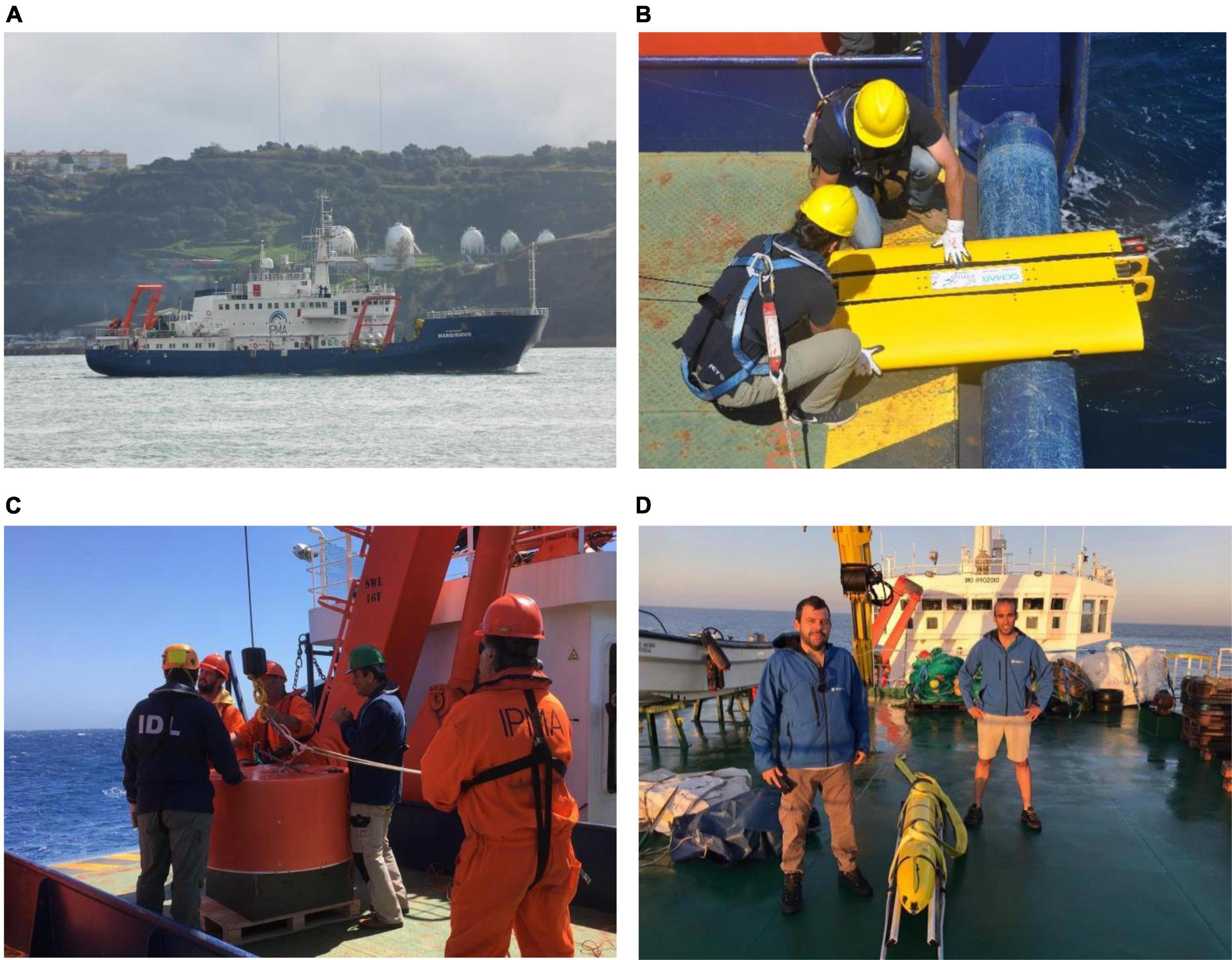
Figure 2. Deployments of oceanographic equipment in the scope of the EMSO-PT pilot oceanographic campaign on-board IPMA’s RV Mário Ruivo. (A) RV Mário Ruivo owned by IPMA. (B) Water column profiler being deployed by the Centre of Marine Sciences and University of Algarve team. (C) Ocean-bottom seismometer deployed by Instituto Dom Luiz and Associação para a Investigação e Desenvolvimento de Ciências teams. (D) Glider deployed by the Institute for Systems and Company Engineering, Technology, and Science Team.
A fixed mooring consisting of a water column profiler and an acoustic doppler current profiler was installed, for the first time, on the Portuguese coast, to measure permanently in the water column: temperature, salinity, chlorophyll, dissolved oxygen, and pH (Figure 2B). The vehicle, powered by wave energy, takes repeated measurements of the first 150 meters of the water column, resulting in about 100 vertical profiles per day, contributing to the knowledge of the vertical structure of the ocean which is essential to validate hydrodynamic models. On October 9th the equipment was recovered with the support of the fishing vessels Finisterra I. After these tests, in the first semester of 2022 the equipment will be deployed.
Three OBSs were deployed and placed on the seafloor to monitor structures that are moving, near the São Vicente canyon and the Gorringe Ridge (Figure 2C). Its aim is to collect data that will allow to understand what types of faults exist and their dynamics. Inside the OBSs, biological traps were placed to identify bacteria that live in the depths. On October 14th two OBSs were recovered with the support of RV Mário Ruivo. The third OBS is planned to be recovered in the first semester of 2022. Tests were very positive, and so OBSs will be deployed targeting long-time series starting from 2022.
Within EMSO-PT oceanographic campaign a glider was deployed offshore the coast to test the sampling of a set of chemical and biological variables with the aim of evaluating the effort need to extend Lagrangian observations as a complement to fixed platforms (Figure 2D).
Prior to the campaign, the vessel was equipped with a “FerryBox” (Petersen, 2014). It was used a prototype developed by Undersee, created in 2016 and launched under European Space Agency – Business Incubation Centres Portugal to develop the first Portuguese “FerryBox” system, that allowed for autonomous water monitoring while the ship was underway. Sensors available include water temperature, salinity, chlorophyll, pH, and dissolved oxygen. Further tests of this prototype, or similar instruments, will be done in the following sea-missions of RV Mário Ruivo to allow fine tuning for open ocean operation, aiming at its use by commercial ships, and promoting the cooperation with the economic sector in marine data acquisition.
Results from this first survey will be disseminated through EMSO-ERIC channels. For the years to come, annual EMSO-PT oceanographic campaigns onboard the RV Mário Ruivo are planned for the testing, deployment, maintenance and/or recovery of equipment and data dissemination will follow the same procedure.
A short documentary about the EMSO-PT pilot oceanographic campaign is available from IPMA’s YouTube channel. Not only this documentary is relevant in terms of reaching the scientific community and national administration in terms of the effort necessary to perform these surveys, but it is also very relevant in terms of outreach targeting general society aiming at raising awareness. Besides being available on-line, on October 12th, 2021, the documentary was presented in two sessions of “FIC.A – International Science Festival” a Portuguese festival that offers a programme focused in the fields of science, technology, culture and art. Other short movies and outreach initiatives – mostly linking with visits from schools to the RV Mário Ruivo – are either done or planned in the scope of EMSO-PT initiative. Another example of a science communication video is also available at IPMA’s YouTube channel describing the EMSO-PT project and the importance of sea observatories. This movie presents the water column profiler deployed in the first EMSO-PT oceanographic campaign and the deep sea observatory EGIM to be deployed in 2022.
With the start of the UN Decade of Ocean Science, research priorities to support the sustainable use of ocean and coastal resources and their conservation are in the spotlight. With the increased awareness that science is the baseline to address this challenge, at present we are at the most favorable time to boost initiatives that converge to wider geographic scope initiatives as EMSO-ERIC. This adds an additional responsibility to scientists that must be ready to take advantage of this opportunity. Now is the time to take a step forward in ocean observation, despite (and because of) the complexity of ocean and coastal agendas, the multitude of approaches to marine spatial planning, magnified by often-conflicting interests between economic activities and nature conservation.
EMSO-PT roadmap implies the following stages:
1) to revisit the scientific key issues and science services to be addressed related with the seafloor and water column previously identified in the scope of EMSO-ERIC;
2) to clarify the data needed to address scientific issues and foster means to better identify the needs of information and better connect to stakeholders, including societal needs, in the scope of Blue Growth ambition;
3) to establish a sustainable monitoring program of the seafloor and water column, while resorting to satellite and modeling efforts;
4) to identify new platforms and technology for complementing data acquisition and foster higher coverage of ocean observations by means of fixed platforms (e.g., deployment of two EGIM’s off the Portuguese coast in 2022) to extend Eulerian observations and also mobile platforms (e.g., autonomous vehicles) to extend regular Lagrangian observations to major water masses that interact with the different Portuguese Atlantic territories;
5) to reinforce the link of EMSO-PT with the goals of other initiatives, such as the GEOSTAR mission (Beranzoli et al., 2002; Miranda et al., 2015), that targeted to deploy in the sea-bed a bottom station designed to support operation of a wide range of sensors able to collect multidisciplinary data on the same location;
6) to strengthen the data acquisition, processing, management, and dissemination infrastructure in order to assure its quality and widespread use;
7) to contribute to the establishment of links with and between other ocean observation initiatives, such as OceanSITES, an integral part of the Global Ocean Observing System, to foster the Findable, Accessible, Interoperable, and Reusable (FAIR) data principle, and harmonize data quality control, format and metadata procedures; and,
8) to find strategies to deal with marine big data challenges in the phases of data storage, data computing, and analysis in accordance of the guidelines of EMSO-ERIC and other initiatives led by IPMA, as the “Atlantic Observatory – Data and Monitoring Infrastructure” project (Silveira et al., 2022) and the digital platform “we are Atlantic.”
The pressures on the ocean and its resources will increase in the next decade owing to climate change and human activities. Our ability for sustainable management of the ocean will depend on the data collected and the information and knowledge derived from it. The study of the ocean – open ocean, deep sea or even processes in shallow coastal waters – needs sustained long-term observations and new distributed ocean observatories are required. The means to collect data are vital and ocean observatories must be acknowledged as the backbone of ocean management.
Despite the existence of several platforms capable of data acquisition in Europe, and worldwide, data coverage is asymmetric and still insufficient to deal with new challenges arising in ocean science. This situation must also be seriously taken into consideration because oceans have no watertight borders and unless data coverage is representative, our common ocean is at stake.
“The EU Blue Economy Report 2021” (European Commission, 2021), provides an overview of the performance of the EU economic sectors related to oceans and the coastal environment, and stated a turnover of €650 billion in 2018, and the EU blue economy is referred as being “in good health.” But in the absence of representative ocean data can we assess the impacts of blue economy in its overall success? Adding to the pressure of climate change, human activities and the expected boost of the “Blue Growth”?
EMSO-PT aims to be a contribution toward this end in providing data, information and knowledge converging to the “big picture” of the state of the ocean. It is foreseen that data from fixed Eulerian observations observatories (e.g., EGIM) will be complemented with data collected by mobile platforms (e.g., autonomous vehicles) to extend regular Lagrangian to major water masses that interact with the different Portuguese Atlantic territories. It is foreseen that EMSO-PT will foster the establishment of a multidisciplinary monitoring network joining the efforts of 15 Portuguese research institutions toward interinstitutional cooperation and collaboration, vital for the success of such an ambitious (and needed) goal.
The raw data supporting the conclusions of this article will be made available by the authors, without undue reservation.
MC took the lead in writing the manuscript with input from all authors.
The authors would like to acknowledge the financial support of FCT through the project UIDB/50019/2020 – IDL and EMSO-PT (POCI-01-0145-FEDER-022157).
The authors declare that the research was conducted in the absence of any commercial or financial relationships that could be construed as a potential conflict of interest.
All claims expressed in this article are solely those of the authors and do not necessarily represent those of their affiliated organizations, or those of the publisher, the editors and the reviewers. Any product that may be evaluated in this article, or claim that may be made by its manufacturer, is not guaranteed or endorsed by the publisher.
The authors would like to acknowledge the support of the European Economic Area Financial Mechanism through their programmes in the acquisition of the RV Mário Ruivo (EEA Grants 2009–2014), and by funding the “Atlantic Observatory – Data and Monitoring Infrastructure” pre-defined project, “Blue Growth” Program (EEA Grants 2014–2021).
Barracosa, H., de los Santos, C. B., Martins, M., Freitas, C., and Santos, R. (2019). Ocean literacy to mainstream ecosystem services concept in formal and informal education: the example of Coastal Ecosystems of Southern Portugal. Front. Mar. Sci. 6:626. doi: 10.3389/fmars.2019.00626
Beranzoli, L., Braun, T., Calcara, M., Calore, D., Campaci, R., Coudeville, J. M., et al. (2002). “Geostar: geophysical and oceanographic station for abyssal research,” in Elsevier Oceanography Series, eds N. C. Fiemming, S. Vallerga, N. Pinardi, H. W. A. Behrens, G. Manzella, D. Prandle, et al. 66, 307–315. doi: 10.1016/S0422-9894(02)80036-8
Borja, A., Elliott, M., Andersen, J. H., Berg, T., Carstensen, J., Halpern, B. S., et al. (2016). Overview of integrative assessment of marine systems: the ecosystem approach in practice. Front. Mar. Sci. 3:20. doi: 10.3389/fmars.2016.00020
Borja, A., Santoro, F., Scowcroft, G., Fletcher, S., and Strosser, P. (2020). Connecting people to their oceans: issues and options for effective ocean literacy. Front. Mar. Sci. 6:837. doi: 10.3389/fmars.2019.00837
Carapuço, M. M., Taborda, R., Andrade, C., and de Jonge, V. N. (2021). How to foster scientific knowledge integration in coastal management. Ocean Coast. Manag. 209:105661. doi: 10.1016/j.ocecoaman.2021.105661
Carrilho, F., Custódio, S., Bezzeghoud, M., Oliveira, C. S., Marreiros, C., Vales, D., et al. (2021). The Portuguese national seismic network—products and Services. Seismol. Res. Lett. 92, 1541–1570. doi: 10.1785/0220200407
Dañobeitia, J. J., Pouliquen, S., Johannessen, T., Basset, A., Cannat, M., Pfeil, B. G., et al. (2020). Toward a comprehensive and integrated strategy of the european marine research infrastructures for ocean observations. Front. Mar. Sci. 7:180. doi: 10.3389/fmars.2020.00180
Eikeset, A. M., Mazzarella, A. B., Davíðsdóttir, B., Klinger, D. H., Levin, S. A., Rovenskaya, E., et al. (2018). What is blue growth? The semantics of “Sustainable Development” of marine environments. Mar. Policy 87, 177–179. doi: 10.1016/j.marpol.2017.10.019
European Commission (2008). EU Directive 2008/56/EC of the European Parliament and of the Council of 17 June 2008 establishing a framework for community action in the field of marine environmental policy. Off. J. Eur. Commun. L 164, 19–40.
European Commission (2021). The EU Blue Economy Report 2021. Brussels: European Commission, doi: 10.2771/8217
Ferreira, M. A., Johnson, D., and Pereira da Silva, C. (2016). “Measuring success of Ocean governance: a set of indicators from Portugal,” in Proceedings of the 14th International Coastal Symposium (Sydney, Australia). Journal of Coastal Research, Vol. 75, eds A. Vila-Concejo, E. Bruce, D. M. Kennedy, and R. J. McCarroll Boca Raton, FL: Coconut Creek. 982–986. doi: 10.2112/si75-197.1
Garcia, O., Mihai, D., Dañobeitia, J., del Rio, J., Bartolome, R., Martínez, E., et al. (2017). “Acquisition system for the “EMSO generic instrument module” (EGIM) and analysis of the data obtained during its first deployment at OBSEA site (Spain),” in Proceedings of the 19th EGU General Assembly, EGU2017, Proceedings from the Conference Held 23-28 April, 2017 in Vienna, Austria, Vienna, 13893.
Golden, J. S., Virdin, J., Nowacek, D., Halpin, P., Bennear, L., and Patil, P. G. (2017). Making sure the blue economy is green. Nat. Ecol. Evol. 1:0017. doi: 10.1038/s41559-016-0017
Iwamoto, M. M., Dorton, J., Newton, J., Yerta, M., Gibeaut, J., Shyka, T., et al. (2019). Meeting regional, coastal and ocean user needs with tailored data products: a stakeholder-driven process. Front. Mar. Sci. 6:290. doi: 10.3389/fmars.2019.00290
Korpinen, S., and Andersen, J. (2016). A global review of cumulative pressure and impact assessments in marine environment. Front. Mar. Sci. 3:153. doi: 10.3389/fmars.2016.00153
Liu, Y., Qiu, M., Liu, C., and Guo, Z. (2017). Big data challenges in ocean observation: a survey. Pers. Ubiquit. Comput. 21, 55–65. doi: 10.1007/s00779-016-0980-2
Lotze, H. K., Guest, H., O’Leary, J., Tuda, A., and Wallace, D. (2018). Public perceptions of marine threats and protection from around the world. Ocean Coast. Manage. 152, 14–22. doi: 10.1016/j.ocecoaman.2017.11.004
Miranda, J. M., Matias, L., Terrinha, P., Zitellini, N., Baptista, M. A., Chierici, F., et al. (2015). “Marine seismogenic-tsunamigenic prone areas: the Gulf of Cadiz,” in Seafloor Observatories, eds P. Favali, L. Beranzoli, and A. De Santis (Heidelberg: Springer), 105–125. doi: 10.1007/978-3-642-11374-1_6
Nadine, L., Julien, L., Bertrand, M., Lagadec, J., and Rolin Jean-Francois, J. (2017). “The EGIM, a generic instrumental module to equip EMSO observatories,”in Proceedings of the OCEAN 2017, Aberdeen, doi: 10.1109/OCEANSE.2017.8084824
Pappalardo, M., Beranzoli, L., Favali, P., Best, M., Piera, J., Dañobeitia, J., et al. (2015). EMSO Implementation and Operation: DEVelopment of Instrument Module. Data Management Plan 6.1. Available online at: https://www.emsodev.eu/Files/Deliverables/D6.1-Data-management-plan.pdf
Petersen, W. (2014). FerryBox systems: state-of-the-art in Europe and future development. J. Mar. Syst. 140, 4–12. doi: 10.1016/j.jmarsys.2014.07.003
Polejack, A., Gruber, S., and Wisz, M. S. (2021). Atlantic Ocean science diplomacy in action: the pole-to-pole All Atlantic Ocean Research Alliance. Humanit. Soc. Sci. Commun. 8:52. doi: 10.1057/s41599-021-00729-6
Santoro, F., Santin, S., Scowcroft, G., Fauville, G., and Tuddenham, P. (2017). Ocean Literacy for All – A Toolkit. IOC/UNESCO & UNESCO Venice office Paris (IOC Manuals and Guides, 80 Revised in 2018), Paris: IOC/UNESCO, 136.
Selig, E. R., Hole, D. G., Allison, E. H., Arkema, K. K., McKinnon, M. C., and Chu, J. (2019). Mapping global human dependence on marine ecosystems. Conserv. Lett. 12:e12617. doi: 10.1111/conl.12617
Silva, D., Rusu, E., and Soares, C. G. (2018). The effect of a wave energy farm protecting an aquaculture installation. Energies 11:2109. doi: 10.3390/en11082109
Silveira, T. M., Carapuço, M., and Miranda, J. M. (2022). The ever-changing and challenging role of ocean observation: from local initiatives to an oceanwide collaborative effort. Front. Mar. Sci. 8:778452. doi: 10.3389/fmars.2021.778452
Tanhua, T., McCurdy, A., Fischer, A., Appeltans, W., Bax, N., Currie, K., et al. (2019). What we have learned from the framework for ocean observing: evolution of the global ocean observing system. Front. Mar. Sci. 6:471. doi: 10.3389/fmars.2019.00471
Keywords: Research Infrastructure, ocean data, EMSO-PT, Atlantic Ocean, ocean observatories
Citation: Carapuço MM, Silveira TM, Stroynowski Z and Miranda JM (2022) Portuguese European Multidisciplinary Seafloor and Water Column Observatory Initiative. Front. Mar. Sci. 9:849150. doi: 10.3389/fmars.2022.849150
Received: 05 January 2022; Accepted: 04 February 2022;
Published: 01 March 2022.
Edited by:
Johannes Karstensen, GEOMAR Helmholtz Centre for Ocean Research Kiel, Helmholtz Association of German Research Centres (HZ), GermanyReviewed by:
Robert Andrew Weller, Woods Hole Oceanographic Institution, United StatesCopyright © 2022 Carapuço, Silveira, Stroynowski and Miranda. This is an open-access article distributed under the terms of the Creative Commons Attribution License (CC BY). The use, distribution or reproduction in other forums is permitted, provided the original author(s) and the copyright owner(s) are credited and that the original publication in this journal is cited, in accordance with accepted academic practice. No use, distribution or reproduction is permitted which does not comply with these terms.
*Correspondence: Mafalda Marques Carapuço, bWFmYWxkYS5jYXJhcHVjb0BpcG1hLnB0
Disclaimer: All claims expressed in this article are solely those of the authors and do not necessarily represent those of their affiliated organizations, or those of the publisher, the editors and the reviewers. Any product that may be evaluated in this article or claim that may be made by its manufacturer is not guaranteed or endorsed by the publisher.
Research integrity at Frontiers
Learn more about the work of our research integrity team to safeguard the quality of each article we publish.