- 1NIVA Denmark Water Research (NIVA Denmark), Copenhagen, Denmark
- 2Aquatic Synthesis Research Centre (AquaSYNC), Copenhagen, Denmark
- 3Instituto Português do Mar e da Atmosfera (IPMA), Lisbon, Portugal
- 4Institut français de recherche pour l’exploitation de la mer (IFREMER), Nantes, France
- 5European Environment Agency (EEA), Copenhagen, Denmark
We report identification and mapping of areas in Europe’s seas and coastal areas impacted by contaminants, i.e., areas with concentrations above internationally agreed threshold values. The study is based on (1) a state-of-the-art data set anchored in national monitoring activities, (2) internationally agreed target values and (3) an updated version of the CHASE assessment tool (originally: the HELCOM Chemical Status Assessment Tool). The spatial cover of data enabled us to classify 1,518 spatial assessment units, with 80% of the area assessed determined to be “problem areas”. We have demonstrated that it is possible to make an integrated assessment of contaminants spanning over four marine regions, and 10 marine sub-regions (sensu the EU Marine Strategy Framework Directive), including marine and coastal waters of 30 European countries. The power of combining data of different sources and contaminant categories over larger geographical scales, is potentially and in a long-term perspective the way forward for wider use of multi-metric indicator-based assessment tools supporting informed decision-making.
Introduction
A growing number of environmental policies and strategies, such as the EU Marine Strategy Framework Directive (MSFD; Anon., 2008), the HELCOM Baltic Sea Action Plan (HELCOM, 2007) and the OSPAR Hazardous Substance Strategy (OSPAR, 2010) and lately the EU Zero Pollution Action Plan (EU, 2021) require the EU Member States and Contracting Parties to monitor and assess the marine environment regarding the concentrations and effects of chemicals.
The MSFD and other policy frameworks provide, however, only limited guidance on how to carry out an integrated assessment of ‘chemical status’. Therefore, most assessments of ‘chemical status’ have been made substance by substance focusing on temporal trends and whether existing Environmental Quality Standards (EQS values) have been exceeded or not.
Despite a common understanding of what a Good Environmental Status for Descriptor 8 Contaminants (D8) is (Law et al., 2010; Borja et al., 2018) and interim and integrated assessment for D8 have been demonstrated based on limited set of substances and the associated matrix-specific assessment criteria (see Borja et al., 2014, Borja et al., 2019, Lyons et al., 2017; Maggi et al., 2022). Nevertheless, fully integrated assessments based on more than priority substances and simple assessment frameworks have to our understanding only been undertaken by HELCOM (HELCOM, 2010, Andersen et al., 2016) and by the EEA (2019a).
As a multi-metric indicator-based assessment tool, CHASE (originally: the HELCOM Chemical Status Assessment Tool) enables a more comprehensive assessment, where data representing a wider range of substances and matrices as well as biological effects, can be combined into fully integrated assessments. The CHASE tool was originally developed for the assessment of ‘chemical status’ in the Baltic Sea (see HELCOM, 2010) and has subsequently been applied in the Greater North Sea by Denmark, Germany, Norway and Sweden (Andersen et al., 2016), and the initial testing and application of the tool has demonstrated its potential usage for a wider assessment. In this study, our aim is to illustrate the potential of the CHASE tool for integrated assessments of ‘chemical status’, and to provide substantiated classification and mapping of ‘problem areas’ (PA) and ‘non-problem areas’ (NPA) in Europe’s seas regarding contaminants.
The study area covers Europe’s four regional seas: from the Baltic Sea in the north, the Mediterranean Sea in the south, the North-East Atlantic Ocean in the west and the Black Sea in the east. The physical, chemical and ecological conditions of Europe’s seas are monitored and assessed regularly by the EU Member States as part of their obligations following the EU Water Framework Directive (WFD) and the EU Marine Strategy Framework Directive (MSFD) as well as obligations to regional sea conventions (Baltic Sea: Helsinki Convention; Black Sea: Black Sea Commission; North-East Atlantic Ocean, OSPAR; Mediterranean Sea, Barcelona Convention/Mediterranean Action Plan). More information on the details for reporting is provided by national and regional assessment reports and by the EEA (2019a).
Data sources
This study is based on monitoring data gathered by European countries in their transitional, coastal and marine waters on contaminants concentration in seawater, sediment and biota. Hence, most data are from national monitoring programmes established under the WFD, MSFD or regional sea conventions’ monitoring and assessment strategies. Data are derived from the ICES DOME portal supplemented by data set originating from the European Environment Information and Observation Network (EIONET; www.eionet.europa.eu), the European Marine Observation and Data Network (EMODnet; www.emodnet.eu/chemistry), the Black Sea EMBLAS project (www.emblasproject.org) as well as specific national data entries from France and Portugal. Data covered the period from 2008-2017. To cover areas which would otherwise not have been assessed, some additional samples were included from mussels in the French parts of the Mediterranean from 2000-2005. These accounted for 1.5% of all observations in biota.
For each indicator parameter or substance, an average value was calculated for each assessment unit. Before this, individual concentrations were normalized to relevant reference parameters (e.g. metals in sediments normalised to Al concentration), where possible. Conversion factors were used to estimate concentrations in biota where measurements were made on a different basis (e.g. wet/dry weight) or in a different tissue than the threshold values.
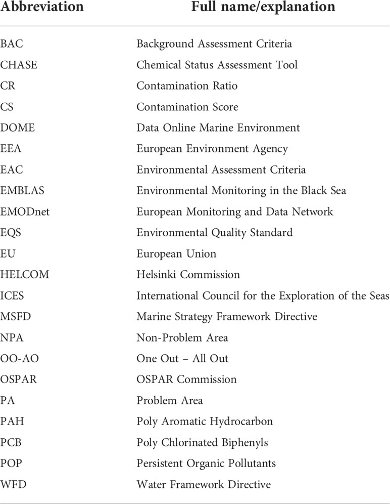
Quantitative threshold values are a prerequisite when applying multi-metric indicator-based assessment tools. The values employed in this study are matrix- and substance-specific. Values for biological effects are taken from OSPAR (2011). The threshold values applied are defined in a different way and include Environmental Quality Assessment Criteria (EQS), Ecotoxicological Assessment Criteria (EAC), Background Assessment Criteria (BAC) and Ecological Quality Objectives (EQOs), please confer with EEA (2019a) for details. EQS and EAC thresholds are based on studies that indicate a concerned risk to the environment if these thresholds are exceeded. Concentrations found below all three types of thresholds are in this study considered as an indication of a clean and healthy environment. Details about the assessment units and the threshold values applied in the study can be found in EEA (2019b). See Table 1 for a list of abbreviations used in the study.
CHASE – a multi-metric indicator-based assessment tool
The benefit of using integrative multi-metric tools is that they give a combined assessment using numerous indicators and allow a coherent inclusion of different substances, matrices, species and analytical methods. There are four categories in the tool – water, sediment, biota and biological effects – by which indicators are grouped. The category ‘water’ includes concentrations of contaminants in the pelagic environment and ‘sediment’ includes concentrations of contaminants in the environment which reflect long-term contamination. The category ‘biota’ includes the concentrations of contaminants accumulated in organisms. In fish, seven species accounted for 90.5% of measurements (Clupea harengus, Limanda limanda, Platichthys flesus, Gadus morhua, Perca fluviatilis, Pleuronectes platessa, Zoarces viviparus) while 94.5% of measurements in other organisms were from three mollusc species (Crassostrea gigas, Mytilus edulis, Mytilus galloprovincialis). ‘Biological effects’ does not include direct measurements of concentrations but reflects the potential impact of multiple and/or specific substances on selected species. This category includes observations for two different indicators: Vas Deferens Sequence Index (VDSI) measured in five different species of marine snails and Lysomal Membrane Stability (LMS) in two fish species. The four categories combined provide a wider and more comprehensive picture of the overall status of environmental contamination. Further, every indicator is associated with an agreed threshold value.
Most indicators in a CHASE assessment show a numerically positive response to worsening environmental status. They are directly related to concentrations of substances where increasing concentration is associated with deterioration of environmental status. CHASE can, however, also accommodate indicators showing a numerically negative response to deterioration of environmental status. Biological effect indicators, such lysosomal membrane stability for instance, display negative response with worsening status.
The CHASE tool employs a simple scheme, whereby each indicator is assessed against a threshold level, and the calculated contamination ratios are then combined to obtain the status for each category. For each of the indicators (n) at an assessment unit (see Appendix A), the contamination ratio (CR) of the measured concentration (Cm) to a relevant assessment criterion for good environmental status (Cthreshold) is calculated using:
Integration of the CRs of the indicators within a category is done by calculating a Contamination Score (CS):
The two equations adhered to the notion that if all indicator CRs were equal to 1, then the resulting integrated value should also be equal to 1. The Contamination Score minimizes the problem of ‘dilution’ of high values when several substances from an assessment unit were analysed and takes into some account possible synergistic effects of contaminants by using the square root of ‘n’ instead of just ‘n’. For the ‘biological effects’ category, indicator CR values are aggregated by taking a simple average.
The status for each of the four categories is first assessed separately. The overall status is defined as the lowest status of the four categories, based on the ‘one out, all out principle’ (OO-AO). The OO-AO approach was considered appropriate because all the categories represent different aspects of the same environment. Moreover, the applied approach gives equal weight to all the categories because contamination in any category is considered potentially equally harmful to the ecosystem.
The final step of the integrated assessment combines the status of each category, to assign an overall integrated status class in each assessment unit: bad, poor, moderate, good and high (Figure 1). The bad, poor and moderate status classes indicate environmental ‘problem areas’ (PA) which are affected by hazardous substances The good and high-status classes indicate an environmental state unaffected by hazardous substances and thus defined as ‘non-problem areas’ (NPA). Hence, the CHASE classification system can be considered essentially binomial (unaffected vs. affected) based on a threshold value. Other class boundaries are determined as defined deviations from the unaffected/affected boundary. The threshold between good and moderate status corresponds to a Contamination Score of 1.0. The high-good threshold is 0.5, the moderate-poor threshold 5.0, and the poor-bad threshold is 10.0.
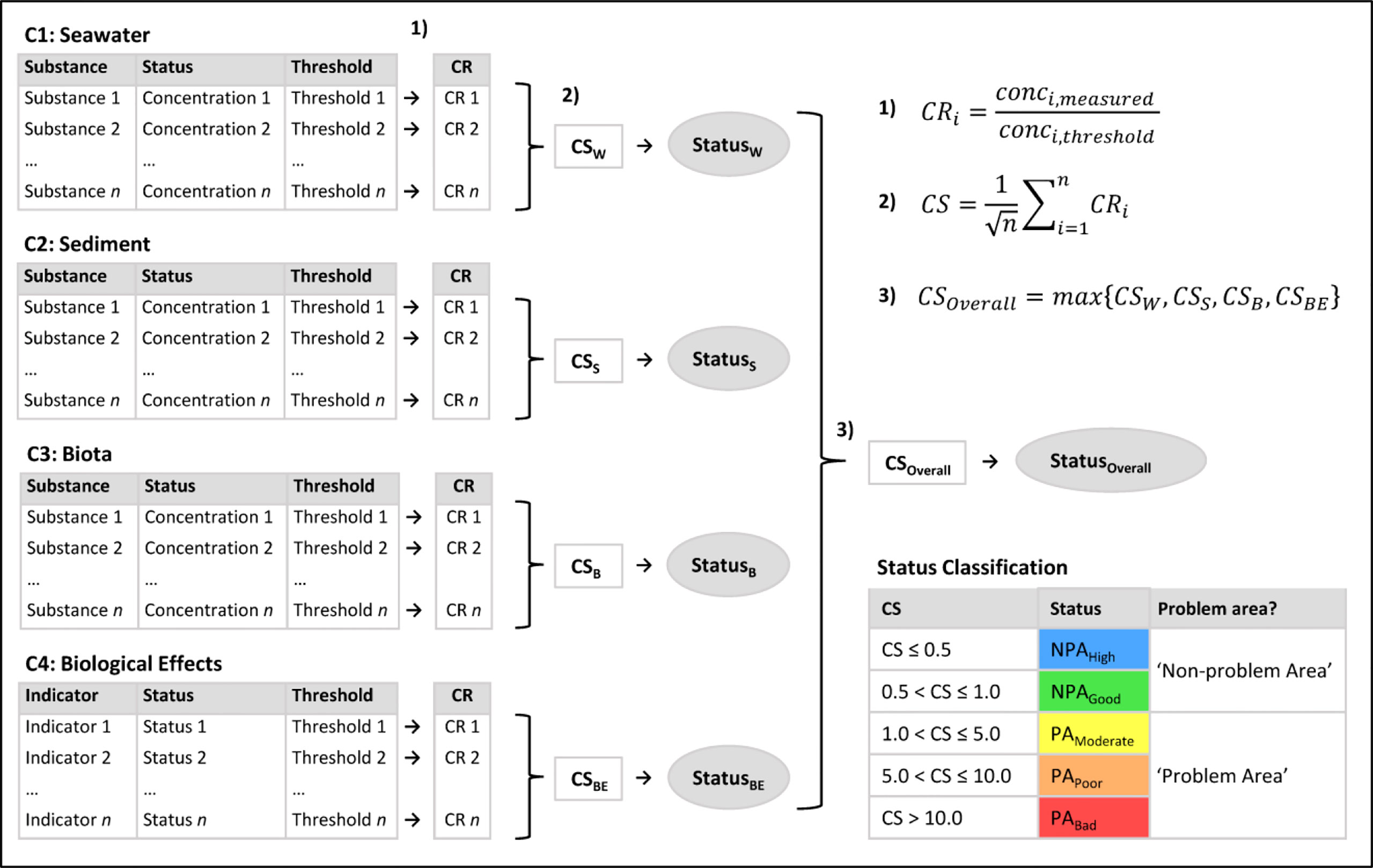
Figure 1 Sketch of the CHASE method. Indicators are grouped in four categories: C1: concentrations in water, C2: concentrations in sediment, C3: concentrations in biota and C4: biological effects. A Contamination Ratio (CR) is calculated for each indicator/substance (Equation 1). For categories 1, 2 and 3, the Contamination Score (CS) is calculated (Equation 2). The CS determines the status for each category, according to the table “Status Classification”. The integrated CS is determined as the maximum score for all categories (Equation 3), and thereby the integrated CHASE classification of the overall status within an assessment unit is given by the ‘one out-all out’ principle. Please note, that for biological effects (C4), CHASE calculates a mean Contamination Ratio rather than using Equation 2.
Analysis and discussion
Europe’s seas were divided into 20 km x 20 km grid cells in coastal areas and 100 km x 100 km grid cells in offshore areas (defined in a Lambert Azimuthal Equal Area reference system). This gave 7,085 assessment units (AUs), 1,100 defined as offshore and 5,985 defined as coastal. Data availability allowed contamination status to be assessed in 1,518 AUs covering a total of 1,475,221 km2. With a total estimated area of 10 243,474 km2, we have thus been able to assess 14.4% and identify ‘problem areas’.
The threshold values applied (see Supplementary Material) are identical to values used by regional seas conventions (see HELCOM, 2010; OSPAR, 2011; OSPAR, 2017; HELCOM, 2018) as well as the European Environment Agency (see EEA, 2019a; EEA, 2019b). There is a well-justified scientific consensus on all but a few of these values but some, for example for metals, are still subject to discussion and final agreement. Some of the current values for specific substances/matrices could be better justified but to avoid potential criticism for data censoring, none of these were excluded.
Water
For the category ‘water’, data coverage for coastal areas was good in the southern Baltic Sea, the North-East Atlantic Ocean, the Mediterranean Sea and the Black Sea. The coastal areas of the northern parts of the Baltic Sea, the Barents Sea, the western parts of the Mediterranean Sea and the Norwegian Sea had poor coverage. For offshore waters, data coverage was good in the western parts of the Baltic Sea and the Greater North Sea. Further, it seems that some countries in northern Europe focus their monitoring on other matrices than ‘water’: i.e., Denmark, Estonia. Finland, France, Latvia and Sweden. Accordingly, there is a large variation in the number of assessed areas in the four regional seas of Europe. For the Baltic Sea, the Black Sea, the Mediterranean Sea and the North-East Atlantic Ocean, the area where data enabled an assessment of ‘water’ was 33,870 km2 (8.5% of the total area), 111,224 km2 (23.4%), 62,954 km2 (2.5%) and 471,885 km2 (6.9%), respectively. The area of ‘non-problem areas’ as a fraction of the assessed area was 9.6%, 10.6%, 2.7% and 13.9% in the Baltic Sea, Black Sea, Mediterranean Sea and North-East Atlantic Ocean, respectively (see Figures 2, 3A). Overall, on a European scale, 87.9% (597,619 out of 679,932 km2) of the area assessed for ‘water’ was classified as ‘problem areas’.
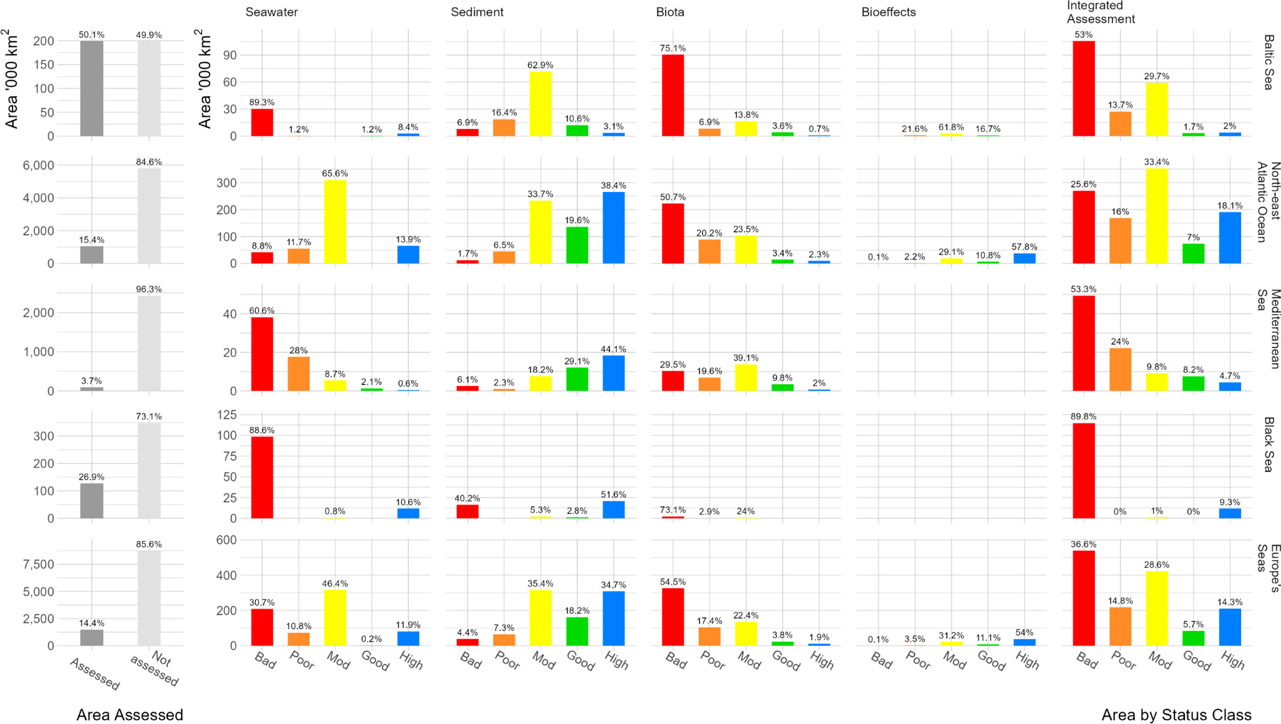
Figure 2 Summary of the CHASE classification in the four regional seas (Baltic Sea, Black Sea, Mediterranean Sea and North-East Atlantic Ocean). The results are categorised into five classes, where 'non-problem areas' are presented as NPAhigh and NPAgood and 'problem areas' as PAmoderate, PApoor and PAbad. See Figure 1 for the definition of the five classes. Please note that Figure 3 is based on these results.
Of AUs where CR exceeded 1.0 (i.e., status was ‘problem area’), substances with the highest CR values were metals in 320 AUs, covering 72.7% of the 436,479 km2 where assessment of the water category resulted in a classification ‘problem area’, other organohalogens in 108 AUs (17.9%), PCBs in 87 (6.0%), PAHs in 76 AUs (3.3%). Organotins and organochlorines were each the substance group with highest CR in 1 AU (<0.1%). It can be noted that substances which consistently exceed threshold values are copper, zinc and heptachlor. Observations of heptachlor are not found in the Baltic Sea but here concentrations of PFOS were consistently above the threshold value.
Sediments
For the category ‘sediments’, data coverage was slightly better than ‘water’ with a total of 888,155 km2 assessed, with good spatial cover in the southern parts of the Baltic Sea, the Bay of Biscay, the western parts of the Black Sea, the Celtic Sea, the North Sea and the coastal waters of France, Italy and Portugal. Sediments were not monitored in the Icelandic Sea, Macaronesia, offshore parts of the Mediterranean Sea and the Norwegian Sea. The area assessed was 114,159 km2 (28.7% of total area) in the Baltic Sea, 40,271 km2 (8.5%) in the Black Sea, 41,574 km2 (1.6%) in the Mediterranean Sea and 691,161 km2 (10.1%) in the North-East Atlantic Ocean. For ‘sediments’, the fraction of assessed area classified as ‘non-problem area’ was 13.7%, 54.4%, 73.2% and 58.0% in the Baltic Sea, Black Sea, Mediterranean Sea and North-East Atlantic Ocean, respectively (see Figure 2). On a European scale, 47.1% (469,787 km2) was classified as a ‘problem area’ (Figure 3B). The substances with the highest concentrations exceeding the threshold values were metals (191 AUs, 60.7% of the problem areas), PCBs in 55 AUs (4.3%), organotins in 46 AUs (3.8%), PAHs in 44 AUs (8.3%), other organohalogens in 26 AUs (22.7%), and organochlorines in 1 AU (<0.1%). In sediment, no substances are as consistently problematic as in water but the group “metals” having the greatest exceedance of threshold values is also seen in the concentrations of individual metals. TBT is a particular problem in the Baltic Sea: concentration exceeded the threshold in 51.5% of assessment units where it was measured.
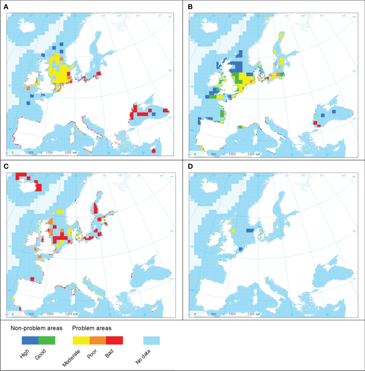
Figure 3 Integrated CHASE classifications for each category; (1) seawater (A), (2) sediments (B), (3) biota (C), and (4) biological effects (D). Additional detailed maps can be found in the Supplementary Material.
Biota
For the category ‘biota’, 598,373 km2 was assessed, slightly less than for ‘water’ or ‘sediments’ and represented 5.8% of the total area. Biota is included in the monitoring activities of most European countries, especially in coastal waters, but significant spatial data gaps are present, especially in parts of the Black Sea and the Mediterranean Sea. For the Baltic Sea, the Black Sea, the Mediterranean Sea and the North-East Atlantic Ocean, the area assessed was 120,591 km2 (30.3% of total area), 2,891 km2 (0.6%), 335,084 km2 (1.4%) and 439,807 km2 (6.4%), respectively (Figure 3D). The dominant substance groups were organobromines (353 AUs 59.9%), other organohalogens (214 AUs 21.6%), metals (200 AUs, 17.4%), organochlorines (7 AUs, 0.4%), PAHs (7 AUs, 0.3%), and PCBs (6 AUs, 0.4%). Of particular note are heptachlor, where all assessment units with measurements had concentrations exceeding the threshold value, and the flame-retardant compounds PBDEs (polybrominated diphenyl ethers) with 100% exceedance in the Baltic and North-East Atlantic and 98.3% exceedance in the Mediterranean. DDEP (dichlorodiphenyldichloroethylene) was similarly problematic with >90.0% exceedance overall.
Biological effects
For the ‘biological effects’ category data availability was very poor, with only 69,508 km2 assessed in the Baltic Sea and the North-East Atlantic Ocean. 65.1% (45,311 km2) was classified as ‘non-problem area’ (Figure 3D). In 57 out of 63 assessment units classified as problem areas (49.6% by area), the indicator exceeding the threshold values was imposex. The indicator for Lysosomal Membrane Stability exceeded the thresholds in six AUs (50.4%).
Integrated assessment
When combining the four categories ‘water, ‘sediment’, ‘biota’, and ‘biological effects’ into an integrated assessment of contamination status, we identify both ‘problem areas’ and ‘non-problem areas’ on a pan-European scale, something which in our understanding has not been attempted previously. A total of 1,475,221 km2 (1,541 assessment units) has been assessed. All regional seas are covered in this study, some better than others. Of the area assessed, 1,180,057 km2 (80.0%) has been classified as being a ‘problem area’ with respect to contamination (Figure 4). The area assessed as ‘non-problem area’ and indicating a healthy status was 295,164 km2 (20.0%). The percentage of ‘non-problem areas’ per regional sea was 3.7% in the Baltic Sea, 9.3% in the Black Sea, 12.9% in the Mediterranean Sea and 25.1% in the North-East Atlantic Ocean.
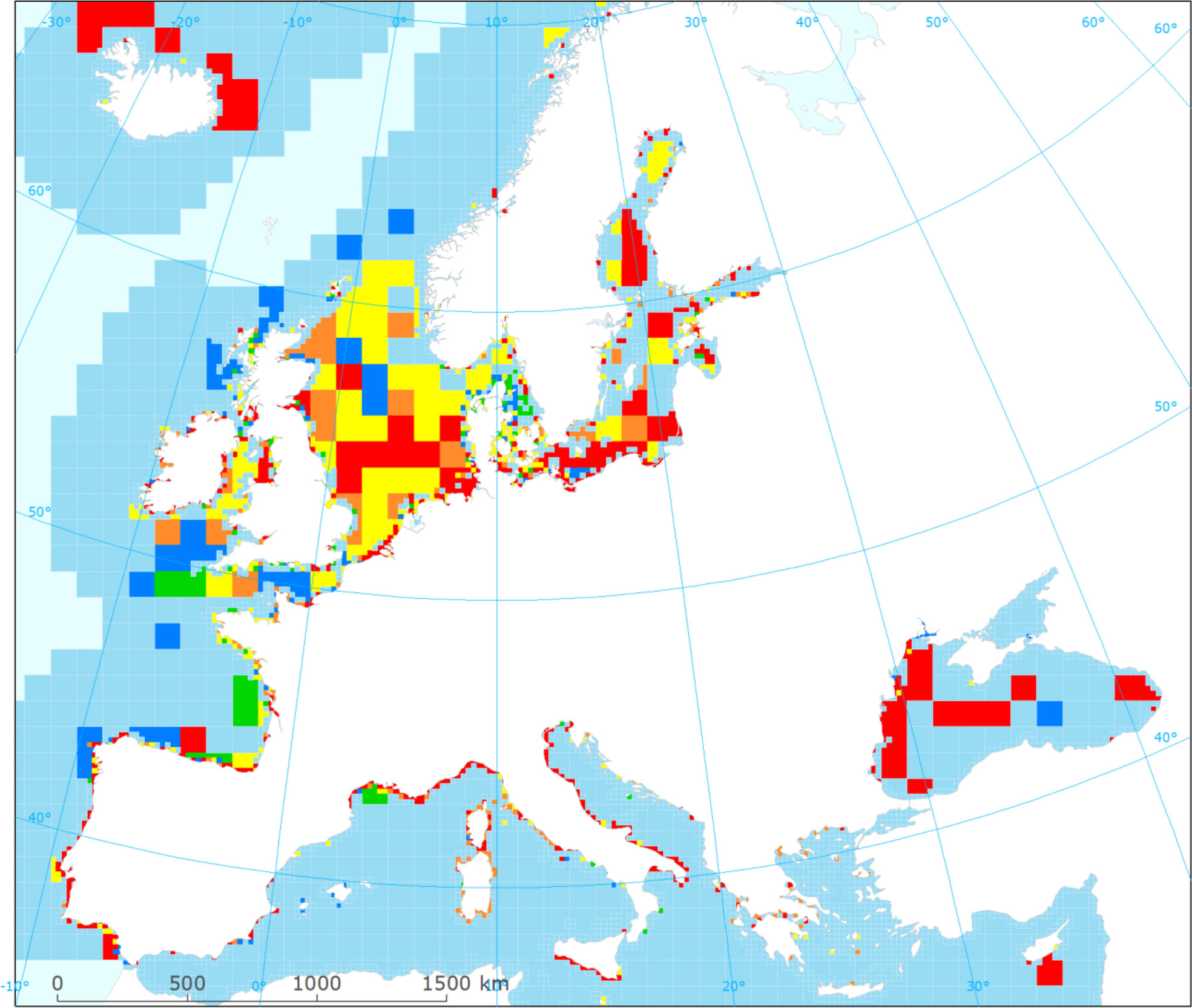
Figure 4 Mapping of contamination ‘non-problem areas’ (NPA) and ‘problem areas’ (PA) based on a European-wide application of CHASE. Maps of sub-regions can be found in the Supplementary Material. Please note the colour coding is the same as in Figures 2, 3.
In the Baltic Sea, 7,331 km2 was classified as ‘non-problem area’ and 192,133 km2 as ‘problem area’. Despite some gaps in the spatial coverage on the west coast of Latvia, in Russian coastal waters and in some Swedish and Finnish coastal waters, the spatial coverage can be considered adequate. In the Black Sea, the coverage of the assessment is limited to the western parts. Access to relevant monitoring data seems to be a challenge. Of 127,761 km2 assessed 11,834 km2 (9.3%) has been classified as ‘non-problem area’.
Spatial coverage appears to be good in many coastal waters of the Mediterranean Sea. However, some gaps have been identified in Spanish waters, in eastern parts of the Adriatic Sea and in some parts of Greek, Italian and Turkish waters. Spatial coverage in offshore waters is poor: only two assessment units are included, one south of Marseille, France, and one south of Cyprus. A total area of 92,464 km2 has been assessed, and 11,926 km2 (12.9%) has been identified as a ‘non-problem area’.
Due to good availability of monitoring data in most sub-regions of the North-East Atlantic Ocean, a total of 1,055,532 km2 could be assessed. Data coverage is very good in the North Sea and the Skagerrak. Coverage is also good north of Iceland as well as in the Channel, around the UK and the Bay of Biscay. Data coverage for the coastal waters of Portugal and Ireland was also good. Gaps in data have been identified along the west coast of Norway, south of Iceland, in Macaronesia as well as in the offshore regions of the North-East Atlantic Ocean. Of the assessed area, 264,074 km2 (25.1%) was classified as ‘non-problem area’.
The substances or indicators most often causing classification as ‘problem area’ are metals (477 AUs, 488,052 km2), organobromated (293 AUs, 317,873 km2), other organohalogens (268 AUs, 290,595 km2), PCBs (109 AUs, 41,496 km2), PAHs (85 AUs, 27,991 km2), organotins (32 AUs, 9,259 km2), imposex (28 AUs, 6,981 km2) and organochlorines (5 AUs, 1,594 km2).
Conclusions
The study covers all of Europe´s regional seas, the Baltic Sea, the Black Sea, the Mediterranean Sea, and the North-East Atlantic Ocean and 8 marine sub-regions (sensu MSFD; see EEA, 2021) and included data from 27 countries. The data coverage is indeed not flawless, but better than expected, especially for coastal waters. 1,541 assessment units were assessed, covering 1,475,221 km2 out of 10,243,474 km2. Of this area, 1,180,057 km2 (80.0%) was classified as a ‘problem area’ with respect to contamination, meaning that at least one substance exceeds the pre-agreed threshold levels – or many substances were just below agreed levels. This indicates that a large fraction of the areas in Europe is affected by a high contamination rate with effects on the ecosystems in terms of reproduction failures, deformities, and food unfit for human consumption.
This integrated assessment of chemical status shows that it is indeed possible to identify ‘problem areas’ and ‘non-problem areas’ with respect to contamination across Europe’s seas despite the large number of substances in existence and the vast diversity of substances monitored by individual monitoring pro-grammes: 1) although there is a reasonable data coverage, this could be improved both by ‘mining’ for further data as well as development of monitoring activities, 2) for some substances, the threshold values applied do not adequately reflect the concentrations at which the boundary between ‘problem’ and ‘no-problem’ is exceeded and these could be improved, and 3) whilst concentrations of some substances are measured in monitoring programs they cannot be included in the assessment before recognized threshold values are available. Including further substances would improve the confidence of the assessment results.
To summarize, we see that there is still, throughout Europe’s seas, individual substances or groups of substances whose concentrations exceed agreed threshold values. The monitoring approaches are also found to differ between regional seas in terms of the matrices samples: 1) in the Baltic Sea, concentrations in biota are widely monitored; 2) in the Black Sea concentrations in water are the most commonly used; 3) water and sediment are the most widely monitored matrices in the Mediterranean; 4) in the North-East Atlantic Ocean measurements in water, sediments and biota are common, and 5) it is only in the Baltic and the North-East Atlantic Ocean that monitoring includes observations of ‘bio-effects’.
The CHASE tool could be a relevant supplement to the ways chemical status is harmonised, assessed, and reported under the WFD and MSFD and by regional seas conventions. The results can be used to map ‘problem areas’ and ‘non-problem areas’, where CHASE values < 1.0 represent not only ‘non-problem areas’, but also areas that are likely to be clean and healthy and thus attaining the overarching goal of good environmental status.’
Data availability statement
The data analyzed in this study is subject to the following licenses/restrictions: There are no restrictions, please contact the corresponding author for a copy of the data. Requests to access these datasets should be directed to amhhQG5pdmEtZGsuZGs=.
Author contributions
JA: Conceptualization, methodology, writing – draft, writing - review & editing. MC: Data curation, writing - review & editing. AG-P: Data curation, writing - review & editing. EH: Analyses, writing – draft, writing - review & editing. JR: Conceptualization, writing – draft, writing - review & editing. CM: Methodology, data curation, analyses, writing – draft, writing - review & editing. All authors contributed to the article and approved the submitted version.
Acknowledgments
This work was indirectly supported by the European Environment Agency’s Topic Centre on Inland Coastal and Marine Waters (ETC ICM). The International Council for the Exploration of the Seas (ICES; www.ices.dk), the European Marine Observation and Data Network (EMODnet; www.emodnet.eu/chemistry) and Aourell Mauffret (IFREMER, France) are thanked for providing many of the data on which the study is based. Special thank are due to Norman Green for valuable discussions and comments to earlier version of the manuscript. We also thank Samuli Korpinen, Martin M. Larsen and Jakob Strand for discussions of earlier versions of the CHASE tool. Many thanks are also due to Emilie Kallenbach (NIVA Denmark), Hans Mose Jensen and Perikles Panagiotides (ICES) as well as Mustafa Aydin, Carsten Jensen and Caroline Whalley (EEA) for support in relation to the EEA thematic assessment report on contaminants in Europe’s seas.
Conflict of interest
The authors declare that the research was conducted in the absence of any commercial or financial relationships that could be construed as a potential conflict of interest.
Publisher’s note
All claims expressed in this article are solely those of the authors and do not necessarily represent those of their affiliated organizations, or those of the publisher, the editors and the reviewers. Any product that may be evaluated in this article, or claim that may be made by its manufacturer, is not guaranteed or endorsed by the publisher.
Supplementary material
The Supplementary Material for this article can be found online at: https://www.frontiersin.org/articles/10.3389/fmars.2022.1037914/full#supplementary-material
References
Andersen J. H., Murray C., Larsen M. M., Green N., Høgåsen T., Gustavson K., et al. (2016). Development and testing of a prototype tool for integrated assessment of chemical status in marine environments. Environ. Monit. Assess. 188, 115. doi: 10.1007/s10661-016-5121-x
Anon (2008). Directive 2008/56/EC of the European parliament and of the Council of 17 June 2008 establishing a framework for community action in the field of marine environmental policy (Marine Strategy Framework Directive). Off. J. Eur. Communities 164, 19–40.
Borja A., Elliott J. H., Andersen J., Carstensen J. G., Ferreira A. S., Heiskanen J. C., et al (2018). Good Environmental Status of marine ecosystems: What is it and how do we know when we have attained it? Mar. Pollut. Bull. 76, 16–27. doi: 10.1016/j.marpolbul.2013.08.042
Borja A., Garmendia J. M., Menchaca I., Uriarte A., Sagarminaga Y. (2019). Yes we can! Large-scale integrative assessment of European regional seas, using open access databases. Front. Mar. Sci. 6, 19.
Borja A., Prins T. C., Simboura N., Andersen J. H., Berg T., Marques J.-C., et al. (2014). Tales from a thousand and one ways to integrate marine ecosystem components when assessing the environmental status. Frontier Mar. Sci. 1, 72.
EEA (2019a). Contaminants in Europe’s seas. Moving towards a clean, non-toxic marine environment (Copenhagen: European Environment Agency), 61 pp. Available at: https://www.eea.europa.eu/publications/contaminants-in-europes-seas. EEA Report 25/2018.
EEA (2019b). Supplementary material to ‘Contaminants in Europe’s seas’ (Copenhagen: European Environment Agency (EEA). Available at: https://www.eea.europa.eu/publications/contaminants-in-europes-seas/annex/view.
EEA (2021). Available at: https://www.eea.europa.eu/data-and-maps/data/europe-seas-1.
EU (2021). Pathway to a healthy planet for all - EU action plan: 'Towards zero pollution for air, water and soil’ (Bruxelles, Belgium: Communication from the Commission to the European Parliament, the Council, the European Economic and Social Committee and the Committee of the Regions) 21 pp. Available at: https://ec.europa.eu/environment/pdf/zero-pollution-action-plan/communication_en.pdf. COM(2021) 400 final.
HELCOM (2007). HELCOM Baltic Sea Action Plan (Helsinki: Helsinki Commission) 101 pp. Available at: https://helcom.fi/baltic-sea-action-plan/action-plan/.
HELCOM (2010). Hazardous substances in the Baltic Sea. Baltic Sea environment proceedings no. 120B (Helsinki: Helsinki Commission), 116.
HELCOM (2018). State of the Baltic Sea – second HELCOM holistic assessment 2011-2016. Baltic Sea environment proceedings 155 (Helsinki: Helsinki Commission) 155. Available at: https://helcom.fi/wp-content/uploads/2019/06/BSEP155.pdf.
Law R., Hanke G., Angelidis M., Batty J., Bignert A., Dachs J., et al. (2010). Marine Strategy Framework Directive – Task Group 8 Report: Contaminants and pollution effects. JRC Sci. Tech. Rep., 161. doi: 10.2788/85887
Lyons B. P., Bignell J. P., Stentiford G. D., Bolam T. P. C., Rumney H. S., Bersuder P., et al. (2017). Determining good environmental status under the Marine Strategy Framework Directive: Case study for descriptor 8 (chemical contaminants). Mar. Environ. Res. 124, 118–129.
Maggi C., Berducci M. T., Lomiri S., Di Lorenzo B., Venti F. (2022). Integrated chemical status of the Italian marine waters sensu descriptor 8 of the Marine Strategy Framework Directive. Front. Mar. Sci 9, 1006595. doi: 10.3389/fmars.2022.1006595
OSPAR (2010). The north-East Atlantic environment strategy; strategy of the OSPAR Commission for the protection of the marine environment of the north-East Atlantic 2010-2020 (OSPAR agreement 2010-3) (London: OSPAR Commission).
OSPAR (2011). CEMP: 2008/2009 assessment of trends and concentrations of selected hazardous substances in sediments and biota, monitoring and assessment series (London: OSPAR Commission).
OSPAR (2017). OSPAR intermediate assessment 2017 (London: OSPAR Commission). Available at: https://oap.ospar.org/en/ospar-assessments/intermediate-assessment-2017/.
Keywords: contaminants, heavy metals, POPs, classification, chemical status, integrated assessment
Citation: Andersen JH, Caetano M, Grouhel-Pellouin A, Harvey ET, Reker J and Murray CJ (2022) Mapping of contamination problem areas in Europe’s seas using a multi-metric indicator-based assessment tool. Front. Mar. Sci. 9:1037914. doi: 10.3389/fmars.2022.1037914
Received: 06 September 2022; Accepted: 18 October 2022;
Published: 08 November 2022.
Edited by:
Vanessa F. Fonseca, Center for Marine and Environmental Sciences (MARE), PortugalReviewed by:
Claudia L. Mieiro, University of Aveiro, PortugalChristina Zeri, Hellenic Centre for Marine Research (HCMR), Greece
Copyright © 2022 Andersen, Caetano, Grouhel-Pellouin, Harvey, Reker and Murray. This is an open-access article distributed under the terms of the Creative Commons Attribution License (CC BY). The use, distribution or reproduction in other forums is permitted, provided the original author(s) and the copyright owner(s) are credited and that the original publication in this journal is cited, in accordance with accepted academic practice. No use, distribution or reproduction is permitted which does not comply with these terms.
*Correspondence: Jesper H. Andersen, amhhQG5pdmEtZGsuZGs=
 Jesper H. Andersen
 Miguel Caetano
 Anne Grouhel-Pellouin4
 Eva Therese Harvey
 Johnny Reker
 Ciaran J. Murray