 Shusheng Yin
 Jianke Guo1,2
- 1School of Geographical Sciences, Liaoning Normal University, Dalian, Liaoning, China
- 2Key Research Base of Humanities and Social Sciences of the Ministry Education, Center for Studies of Marine Economy and Sustainable Development, Liaoning Normal University, Dalian, Liaoning, China
The coastal zone is a combination of marine and land ecosystems, which represents the core areas of resource utilization in China. The sustainable development of coastal zones should be based on a deep understanding of their resources. Compared with Europe and North America, knowledge of coastal zone resources is more fragmented in China. In recent years, China has used quantitative models to realize integrated coastal zone management, but the theoretical basis and research methods remained incomplete. To this end, we developed an assessment framework for coastal zone territorial space resources, environmental carrying capacity, and spatial suitability from an integrated coastal zone management perspective. We tested this framework in Zhuanghe City, which is located within the Northeast Asian Economic Circle. The results show that the coastal resources and environmental carrying capacity of Zhuanghe City are mainly in a critical state. Land space in the coastal zone is mainly suitable for development, but the functional suitability of different regions significantly differs as more suitable urban areas are clustered on the coastal plain. The proportion of suitable space for agricultural production is ~50.51% and is mostly concentrated on the eastern coastal plain. The proportion of space with high ecological suitability is 14.17%, but it is concentrated in the northern mountainous area; there is low space for high value fishery production. Evaluation of coastline function shows that coastline suitable for production occupies a relatively high proportion, with a length of ~230.63 km, accounting for 80.92% of the total length of the Zhuanghe coastline. The ecological coastline of Zhuanghe City is occupied by industrial development and urban construction; suitable and unsuitable areas overlap and coastline development functions conflict with each other. Therefore, the coastal zone of Zhuanghe City is under great pressure. In China, coastal cities are the final link of integrated coastal zone management. Our research reveals a previously unreported critical situation in the coastal area of Zhuanghe City, especially in terms of fishery and shoreline utilization, which is worrisome in view of the reported production capacity of the city. Our results offer a reference for improving coastal management practices with the aim of alleviating the conflict between spatial development and protection in coastal areas.
1 Introduction
With continuing economic development, demand for the development of land space increases. Moreover, given such factors as the insufficient or lagging supply of relevant institutions (Tang et al., 2022), environmental problems such as waste of land resources and ecological degradation are also exacerbated. As a result, conflict between limited resources, the environment, and unlimited development demand in the territorial space becomes increasingly prominent (Fan, 2019).
The coastal zone is the combination of marine and land ecosystems, and represent the core area of resource utilization in China. The importance of coastal zones has been highlighted in numerous previous studies, and many scholars have focused on coastal zone spaces, integrated management (García, 2015), economic efficiency (Ren et al., 2018), the economic system of the human–sea relationship, and spatial management of the coastal zone (Carlotta, 2018; Nawel et al., 2019; Li et al., 2022).
In the Europe Union (EU), member states follow Integrated Coastal Zone Management (ICZM) and are required to incorporate marine spatial planning (MSP) into coastal zone spatial planning, thereby improving regional development potential (Hietala et al., 2021). In Central America, researchers have focused on the cross-regional spatial use of coastal zones to seek solutions to spatial use conflicts in response to threats such as ecological degradation, cultural conflict, and climate change (Caviedes et al., 2022). In practice, coordination in management policies, spatial planning, and overall strategic planning in coastal zones are all lacking, which is severely threatening the sustainable development of the coastal zone (Cantasano et al., 2017; Victor, 2018). In China, scholars have established a spatial zoning method for coastlines and coastal zones based on the ecosystem, environmental capacity, and disaster risk assessment (Sun and Chen, 2013). Moreover, some studies have considered the regional conditions, resource environment, ecological environment constraints, and other factors to analyse the spatial utilization allocation scheme and optimization path of coastal zone tidal flats (Cheng et al., 2019). Cantasano et al. (2017) introduced the concept of resilience into coastal zone spatial planning and developed coastal zone ecological restoration schemes. With the continuous deterioration of coastal ecological environments, governments have attempted to implement integrated management of the coastal zone. In this way, they aim to realize the coordinated development of spatial resources, optimise the allocation of resources, and achieve sustainable development goals (Cantasano et al., 2017;UN, https://sdgs.un.org/goals).
Carrying capacity was originally introduced as a concept of mechanics and later as a variable in ecosystems and regional systems (Li et al., 2019). In this way, researchers can evaluate the ability of regional resources and environmental endowments to maintain sustainable social development. Previous studies have proposed concepts and evaluation models to quantify the marine carrying capacity (Sun and Chen, 2013; Cheng et al., 2019). In practice, the marine carrying capacity is based on the sustainable utilization of marine resources, marine ecological environment protection, and the ability of the ocean to support the sustainable development of society under the condition of conforming to the current productivity level (Di et al., 2008; Chen, 2017; Rong et al., 2019). More recent studies have considered the evaluation of carrying capacity not only as a single factor but as a multi-factor comprehensive factor, thereby advancing the corresponding research methods (Cheng et al., 2019).
The evaluation suitability of regional space development stems from the concept of land suitability evaluation. In this way, one can evaluate the degree of suitability of land use according to the needs of social development and the characteristics of the natural ecological environment (Tian et al., 2020; Ta and Thi, 2022). The main methods for evaluating the suitability of national spatial development include overlaying comprehensive analysis (Tang et al., 2012), spatial interaction analysis (Yu et al., 2015), and process simulation research (Kuang, 2019), among others. By considering suitability evaluation, one can expand the research scope of the human–land relationship, thereby integrating the relationship between the subjects of spatial interests. In this way, one can also consider social factors to introduce a specialised evaluation index system according to research need (Zhang and Li, 2022). Thus far, China has carried out a new round of territorial and spatial planning (Sun, 2013; Han et al., 2018; Cheng et al., 2019). Both researchers and government departments have discovered the fundamental role of resource and environmental carrying capacity and spatial development suitability evaluation in the national territorial and spatial planning system, and to provide information for regional functional zoning and optimization (Kuang, 2019). A new perspective (Fan, 2019; Dina and Abeer, 2021) has become an important support for national territorial spatial planning; that is, optimal use of national territorial space (Lin et al., 2021).
To date, previous studies have mostly focused on the interplay between coastal resources, environment, and social and economic activities, and have quantified management policy benefits and coastal ecological risk assessments (Theodora and Spanogianni, 2022; Caviedes et al., 2022). Moreover, most previous studies were focused on the environmental assessment of a single resource, which has left gaps in our understanding of the layout, conflict of spatial utilization, and spatial suitability in coastal zones. As coastal zone management is becoming increasingly comprehensive (Caviedes et al., 2020; Pasquali and Marucci, 2021; Caviedes et al., 2022), the evaluation of coastal zone resource and environmental carrying capacity and spatial suitability has also become an important element of coastal management practice (Schipper et al., 2021). Overall, the dilemma of integrated coastal zone management requires deeper examination.
To this end, we developed an assessment framework of coastal zone territorial space resources, environmental carrying capacity, and spatial suitability from the integrated coastal zone management perspective. In particular, we considered coastal county-level administrative units as a study area to (1) analyse spatial planning and (2) apply functional zoning methods of coastal zone county-level administrative units. Our results provide new insight into integrated coastal zone management practices (Figure 1).
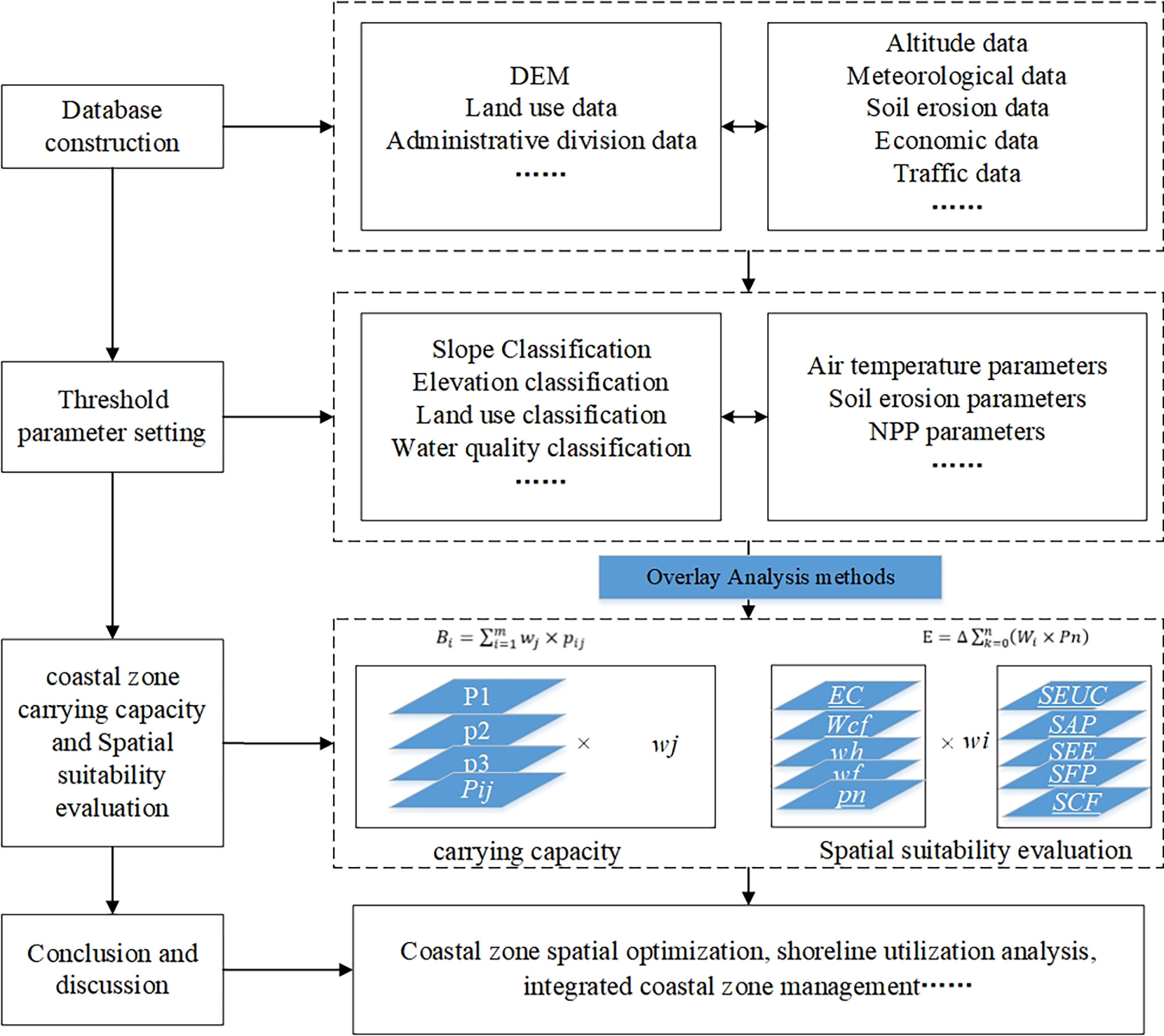
Figure 1 Study framework.
2 Data and methods
2.1 Study area and data sources
Zhuanghe City is located within the Northeast Asian Economic Circle (Bulletin of Economic Statistics of Zhuanghe) and has a land area of 4,115.06 km2, sea area of 2,933.33 km2, and coastline of 373.09 km (the continental coastline is 285 km; Bulletin of Economic Statistics of Zhuanghe). Administratively, there are 26 townships under its jurisdiction, the resident population is 742,000. Zhuanghe has 138,000 hectares of arable land, accounting for 33% of Dalian. The area of breeding is 8000 hectares in tidal flat, 56,000 hectares in shallow sea bottom sowing. Zhuanghe City is a low-mountain hilly area, which belongs to the southern extension of the Qianshan Mountains, and the terrain gradually increases from south to north (The People’s Government of Zhuanghe Municipality). The average altitude in the north is more than 500 meters. The terrain in the central region is dominated by coastal hills, with an altitude of about 300 meters, with streams and small plains mixed in between. The coastal area is a shallow sea accumulation plain with flat terrain and mainly coastal mudflats, with an altitude of less than 50 meters (Zhuanghe Natural Resources Bureau). Zhuanghe City is located in the north temperate zone, with a warm temperate humid continental monsoon climate with certain marine climate characteristics. The annual average temperature is 9.3°C, the extreme maximum temperature is 36.0°C, and the extreme minimum temperature is -28.1°C; because it is in the East Asian monsoon region, the prevailing wind direction changes significantly with the seasonal transition. In winter, affected by the cold high pressure of Mongolia on the Asian continent, the prevailing northerly wind. In summer, due to the strong thermal low pressure of the Indian Ocean and the thermal high pressure of the North Pacific, southerly winds prevail; the precipitation is unevenly distributed in time and space, with an average precipitation of 736.0 mm over the years. The precipitation in July and August accounts for about 50% of the annual precipitation. Affected by the terrain and the monsoon, the precipitation increases from the southwest to the northeast. Zhuanghe is close to the northern shore of the Yellow Sea and has a complex coastline with many natural harbors (Figure 2).
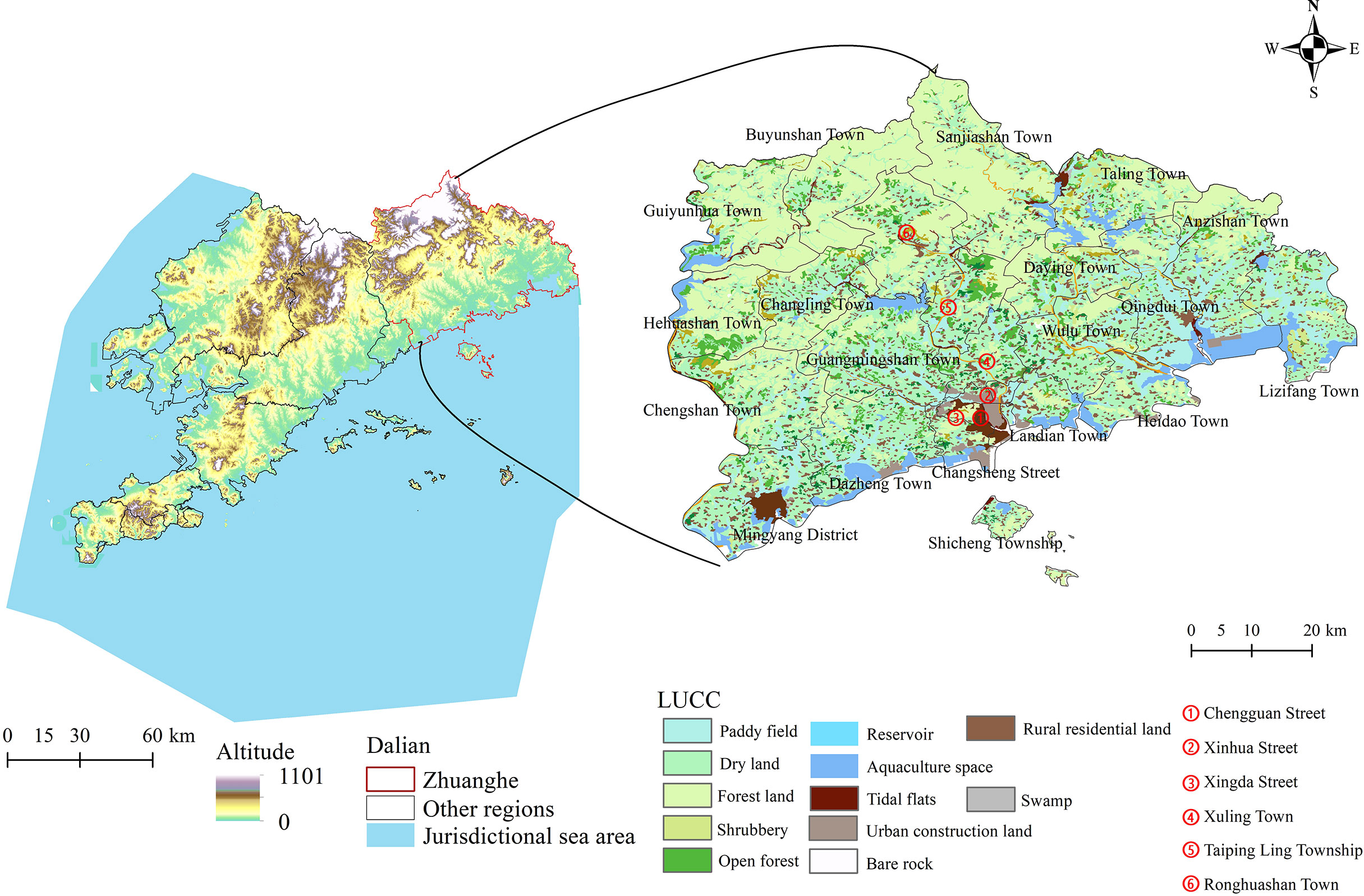
Figure 2 Schematic diagram of the study area location. LUCC, land-use and land-cover change.
Previous studies have stipulated that a basic unit of national city, and county spatial planning should be characterisation of the natural resources, ecological environment, and economic factors (Sun and Chen., 2013). Thus, an evaluation index should be introduced to reflect regional characteristics and diversity. The evaluation should comprehensively consider the actual territorial space needs of coastal cities and counties, and build spatial evaluation methods and models in line with them (Sun and Chen, 2013; Cheng et al., 2019). Several key considerations should help establish a relevant database. To this end, the selection of a natural resources system, ecological environment, social development system, and economic system is key for the evaluation of coastal zone spaces and coastal zone land space for carrying objects (e.g., urban construction, coastal aquaculture, agriculture land space use of activities).
We used various types of data, including basic geographical data, land resources data, water resources data, climate data, ecology data, and social economy data of Zhuanghe City. Some data were corrected by combining remote sensing images and in situ observations (Table 1). The data used in this study were obtained from multiple sources including statistical yearbooks, yearbooks, marine environmental status bulletins, survey data of sea area usage, and remote sensing image data of Zhuanghe City. The area data of the sea, coastline length, total sea area, length of developed and utilised coastlines, and total amount collected from the sea area were obtained from a survey on the current utilization conditions of the sea area and remote sensing image data. Environmental data, such as the comprehensive index of seawater quality, were calculated from relevant data listed in the Dalian Marine Environmental Quality Bulletin (China Marine Economic Statistics Bulletin). The investment in fixed assets, total population, gross domestic product (GDP), and other data were obtained from the Zhuanghe Statistical Yearbook (Zhuanghe Bureau of Statistics).
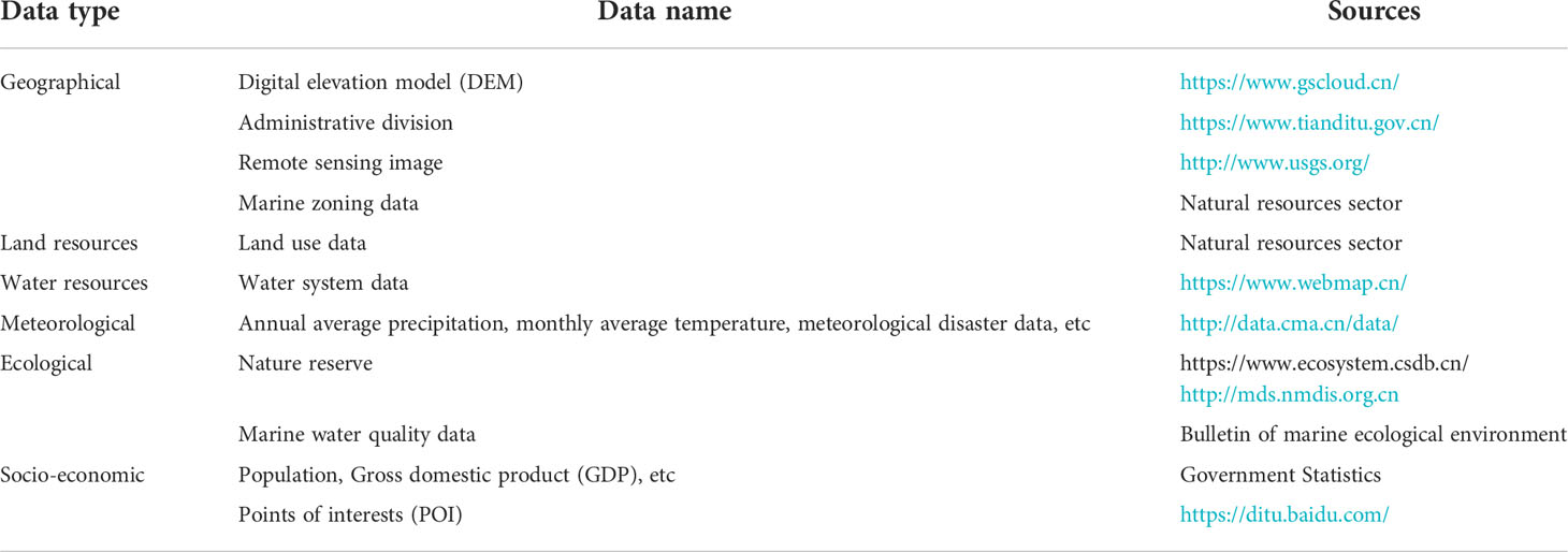
Table 1 Data and sources.
2.2 Research methods
2.2.1 Evaluation system construction
Table 2 shows that the coastal zone spatial suitability evaluation system considers four components: urban construction suitability assessment, agricultural production suitability assessment, ecological spatial suitability assessment, and coastline function suitability assessment. The background evaluation of the spatial natural resources, production environment, and meteorological environment of the coastal zone all require deepening the spatial evaluation of the coastal zone and the protection of important functional areas such as fishery production and ecological protection. (1) Suitability evaluation of urban construction (SEUC) was addressed by considering land resources, water resources, climate resources, the ecological environment, and socio-economic indicators (Pasquali and Marucci, et al., 2021; Caviedes et al., 2022). (2) Suitability of agricultural production (SAP) considered such evaluation indicators as land resources, climate resources, and water resources, while superimposed ecological function was applied for correction (Wang et al., 2022; Wu et al., 2022). (3) Suitability evaluation of ecological space (SEE) was based on the importance of ecological function and ecological system, superimposed on climate resources, water resources and other data, thereby correcting the results (Su et al., 2020). (4) Suitability evaluation of fishery production (SFP) considered marine biological resources, ocean depth, coastline, and other data. In this way, we combined the ecological spatial data for further correction. (5) Suitability of coastline function (SCF) was based on the selection of socio-economic data, basic geographical data, ecological environment data, and marine spatial data for evaluation. Traffic accessibility analysis relied on the network analysis method, and the soil PH value and soil texture evaluation were based on the “Grading Regulations on Agricultural Land Quality”. The coastal water quality was quantified based on remote sensing water quality inversion and corrected according to the “2021 Dalian Marine Environmental Quality Bulletin”. The fishery stock resource data were obtained from the National Marine Data Center (National Science and Technology Infrastructure). The marine fish dataset utilizes observational data and other data sources, and classifies, summarizes, and combines all the collected data to form a dataset in a standard form. The dataset contains high-definition pictures, classification data, and species information of marine fish.
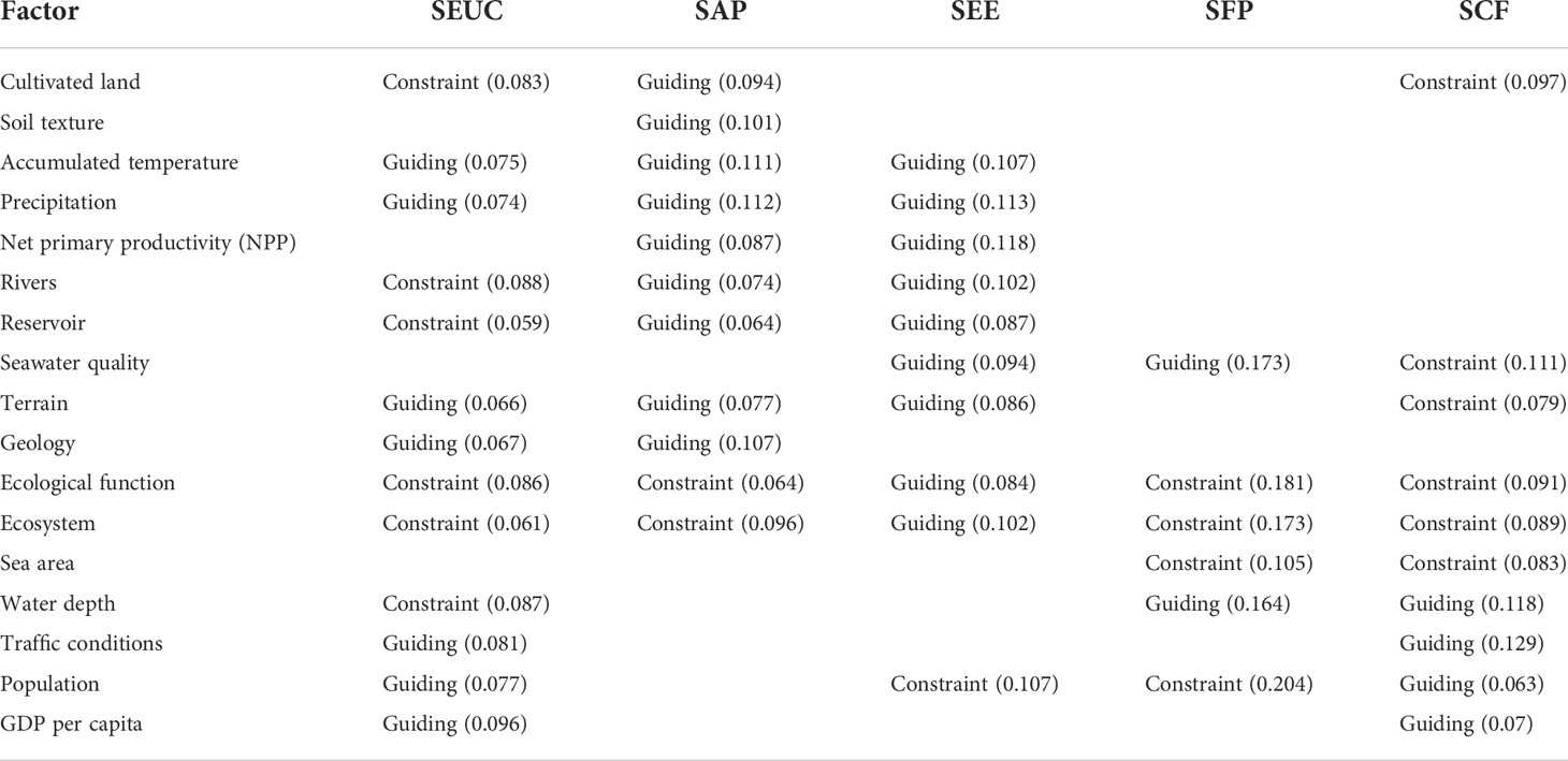
Table 2 Coastal zone spatial suitability evaluation index system.
The evaluation of coastal zone carrying capacity was based on the land resource, marine resource, ecological resource, and water resource. The exact calculation formulae and definitions are summarised in Table 3. Given the differences in the dimensionality of data, the Extremum method was used to standardize them, while the entropy method was applied to determine the weight of a single factor bearing index.
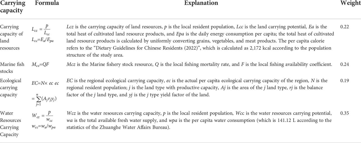
Table 3 Evaluation index of marine resource and environmental carrying capacity in Zhuanghe.
2.2.2 Research methods and evaluation factors
The entropy method was proposed by Shannon (1948). The concept of entropy is well suited to measuring the relative strength of comparison criterion to represent the average intrinsic information involved in the decision. Following Lin et al (Lin et al., 2021),this study uses the entropy method to estimate the weights of indicators and layers. The steps of the model are as follows:
1)Normalize the original data:
Set the original evaluation index matrix of coastal zone carrying capacity as X(xi is the original value of data), where i =1,2,…,m is the number of evaluation samples; j = 1,2,…, n, n is the number of evaluation indicators. To obtain the standardized evaluation matrix, this paper uses the Extreme value standardization method to process the original index.
Positive indicators;
Negative indicators:
2) Estimate the weight of indicator j:
Where wj is the weight of indicator j, wj ∈[0,1],Hj is the information entropy, and fj is an indicators’ weight. The following estimation method is used:
3)Estimate the comprehensive coastal zone carrying capacity (Bi ) of a given region:
The basic requirements of human life and production sites for land resources are mainly reflected in whether the terrain is flat, whether the oxygen content in the air is sufficient, whether the temperature is suitable, and whether the water is convenient, and these conditions are often closely related to the elevation and slope of the terrain. With the increase of terrain elevation, atmospheric pressure will gradually decrease, air will gradually thin, temperature will gradually decrease, and the degree of restriction on human habitation or production activities will become higher and higher; With the increase of the terrain slope, not only will the cost of human life and production increase, but also lead to the intensification of soil erosion (Fan, 2019). For example, terrain elevation and slope can be seen as two key factors in the evaluation of the suitability of land resources for human activities (Zhang and Li, 2022).
The ecological function evaluation (EC) was determined by Eq. (7), where NPPmean is the mean of net primary productivity; Fpre, Ftemp, and Falt are the mean annual precipitation, mean annual temperature, and altitude, respectively(Sun and Chen.,2013).The range was (0,1) based on the extreme value method for data standardization processing.
The water and soil conservation functions were evaluated from Eq. (8) and Eq. (9), respectively. The NPP was considered as the main parameter to calculate the soil and water conservation function based on Eq. (8), where K and Fslp are soil erosion and slope, respectively. Lastly, Kepic is the soil texture factor in Eq. (9) (Wang et al.,2022)
Eq. (10) formalizes the evaluation of water conservation function, where Wh is the water conservation capacity index, Fsoil is the soil texture factor, Fpre is the annual average precipitation, and Fslp is the slope factor(Shen et al,2020).
Eq. (11) introduces the evaluation of windbreak and sand fixation function, where Wf is the evaluation of windbreak and sand fixation function; and K, Fq, and D are the soil erosion factor, climate factor, and surface roughness factor, respectively (Shen et al, 2020).
The overall evaluation results of various structures, denoted as E, can be obtained by multiplying the obtained structural selection values P with the calculated weights W, and Spatial Suitability Evaluation is described in Eq. (12), where spatial Suitability Evaluation (E) reflects the suitability of specific functions, such as agricultural production and urban construction. In coastal areas, we also need to consider the development suitability of coastal fishery resources, ports, and other resources (i.e., P1… Pn). To this end, we determined the spatial suitability of the coastal zone according to the land and space resources conditions.
3 Results and analysis
3.1 Bearing capacity of the Zhuanghe City coastal zone
GIS spatial analysis (Overlay Analysis and Spatial Interpolation methods) (Fan, 2019)was applied to quantify the carrying capacity of the coastal zone of Zhuanghe City (Figure 3). Figure 3A shows that the comprehensive carrying capacity of the coastal zone strongly varies across the towns. Of the analysed areas, Guiyunhua Manchu Township, Chengguan Street, and Hehuashan Town were found to be within the category of the overall carrying state. However, Qingdui Town, Lizifang Town, and Anshan Town are within an overloaded state of marine resources carrying capacity and ecological carrying capacity.
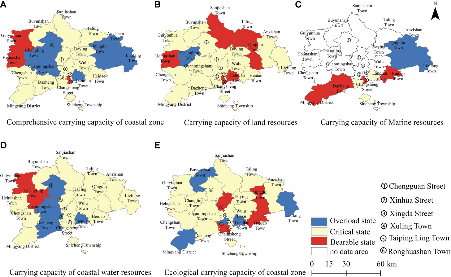
Figure 3 Evaluation of resource and environmental carrying capacity of the coastal zone.
According to the calculation method (Table 3), the carrying capacity was obtained. The levels were obtained through K-means clustering analysis using the SPSS software(IBM SPSS software). The carrying capacity of Zhuanghe City was divided into three levels (Table 4) (Bureau of Natural Resources,Dalian). Notably, the overall carrying capacity of land resources in Zhuanghe City was in a critical state (Figure 3B). Of the analysed towns, Changling Town was overloaded with land resources, while Hehuashan Town, Chengguan Street, Landian Town, Xianrendong Town, Taling Town, and Qingdui Town were all within a loadable state. Furthermore, we analysed the marine resource carrying capacity (Figure 3C) for coastal towns in Zhuanghe City. We identified significant spatial differences in the marine resource carrying capacity. However, the long-term development of marine aquaculture and fishing have caused the overloading of marine resources in three areas: (1) sea areas under the jurisdiction of Dazheng Town and Mingyang Street, which are mainly reserve and ecological areas for which the development of marine aquaculture is low and the carrying capacity of marine resources was found to be in an acceptable state; (2) Changsheng Street, Landian Township, and Shicheng Township were found to be within a critical state; and (3) water resource carrying capacity. Figure 3D illustrates that Zhuanghe City is an important water source protection area for Dalian city; Guiyunhua Manchu township, Changling town, and other areas have large numbers of rivers emptying into the Biliuhe Reservoir, thereby supplying Dalian with water. Guangmingshan Town and Dzheng Town both have large cultivated land areas and larger agricultural water consumption, while Landian Town is characterised by a concentrated population, where water demand is mainly driven by the industry and residents. We found that the ecological carrying capacity of Zhuanghe City was mainly critical (Figure 3E). Buyunshan Township, Mingyang Street, Landian township, Lizifang Township, etc, were identified as being within a state of overload. Buyunshan township is mainly characterised by mountainous terrain, but its ecological environment is somewhat fragile. Lastly, Lizifang Town and Mingyang streets are flat, but the population is concentrated and the development intensity is relatively high, thereby exerting high pressure on the ecological environment. The population of these two townships accounts for 21% of the total population of Zhuanghe City, and all the sea areas under their jurisdiction have been developed for aquaculture. As an important local grain production base, arable land accounts for 11% of Zhuanghe City.
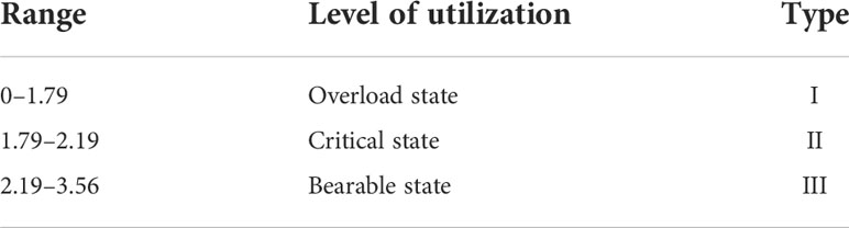
Table 4 Grading types of carrying capacity(Bureau of Natural Resources, Dalian).
3.2 Spatial suitability evaluation of the Zhuanghe City coastal zone
The development suitability indices of coastal urban construction, agricultural production, ecological space, fishery production, and coastline functions were calculated according to the above evaluation index system and method (Table 2 and Table 3). The above-mentioned five categories of spatial suitability were evaluated and analysed by the overlay analysis and standard deviation methods in ArcGIS.
3.2.1 Suitability for coastal zone urban construction
The suitability of urban construction in Zhuanghe City was found to be relatively high with 1,234.20 km2 and 934.11 km2, respectively, accounting for 61.14%(Bulletin of Economic Statistics of Zhuanghe,2021). We discerned clear spatial differences in the adaptability of urban construction, as shown in Figure 4. Suitable construction areas were mainly found in coastal plain areas (Lizifang Town, Qingdui Town, Dazheng Town, etc.); however, point-like distribution with distinct spatial agglomeration characteristics was also identified.

Figure 4 Suitability evaluation of urban construction.
Various evaluation factors (Figure 5) demonstrated that the northern part of Zhuanghe City is dominated by mountains, with an average altitude of > 500 m and low temperature throughout the year (Figure 5A). While topographic conditions limit the type and scale of land use, the ecosystem was found to be unique and important, as shown in Figure 5B. These conditions further constrained the development scope as the Zhuanghe coastal plain has flat terrain (average slope of 3°) (Ministry of Housing and Urban-Rural Development of the People’s Republic of China, Unified Standard for Civil Building Design (GB 50352-2019), 2019), providing suitable conditions for development and construction (Figures 5C, E). The regional transportation network is relatively developed, transportation accessibility is relatively high, and suitable construction areas are distributed in the form of a band (Figure 5D).
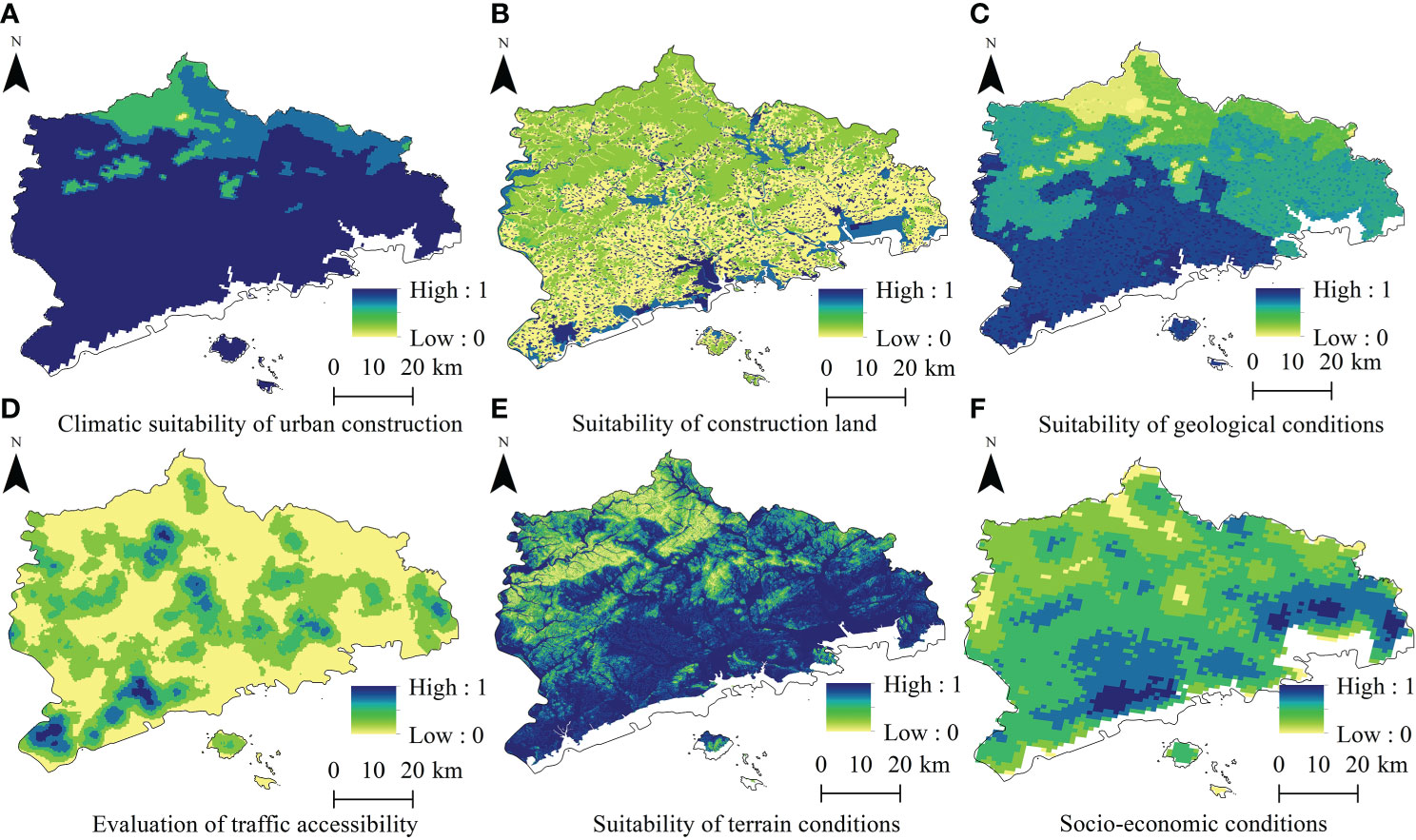
Figure 5 Evaluation of suitability factors for urban construction.
3.2.2 Suitability for agricultural production in coastal zones
From Figure 6, suitable space for agricultural production accounted for an area of ~2,077.77 km2 (or 50.51%). The less suitable and unsuitable spaces occupied ~2,024.73km2, of which the unsuitable space accounted for 48.9% and was mostly identified in the northern mountains. High-value areas of agricultural production suitability were found in the eastern coastal plain.
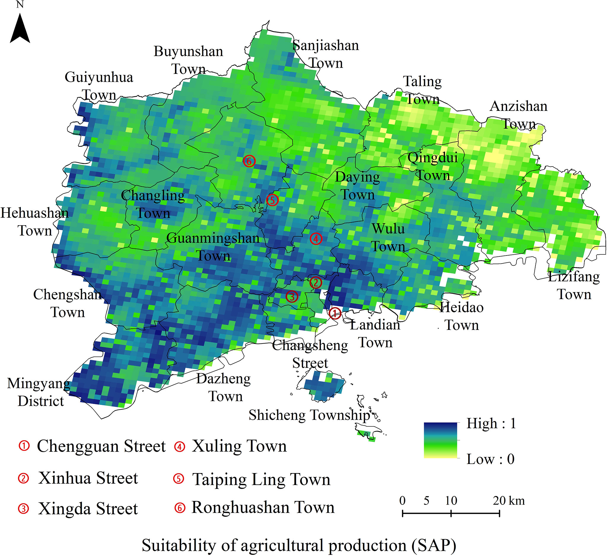
Figure 6 Evaluation of the suitability of agricultural production.
The evaluation of various factors in terms of climate resources is shown in Figure 7. As seen, these factors were mainly affected by terrain and climate (Table 2). The annual average precipitation in Zhuanghe City is 736.00 mm, decreasing from ‘southwest to northeast’, whereas the spatial difference of the annual average accumulated temperature is the same as that of precipitation (Wu et al., 2022). Analysis of the agricultural environment (Figure 7B) demonstrated that some towns in the central and northern regions are dominated by mountainous terrain, where a large area belongs to nature reserves. The ecological environment in these areas is fragile and not suitable for large-scale agricultural development. Moreover, environmental protection is under great pressure as the agricultural land resources in Zhuanghe City were shown to be relatively low. However, large areas of the land suitable for cultivation were identified, with mainly brown and/or sandy soil, weakly acidic pH, good air permeability, and fertile soil (Figure 7C).
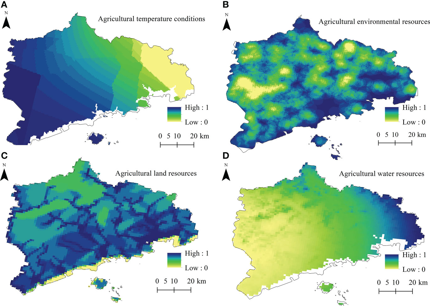
Figure 7 Factors for evaluating the suitability of agricultural production.
In terms of agricultural water resources, precipitation decreased from the southwest to the northeast; the northern mountainous area received low precipitation. However, owing to numerous rivers in Zhuanghe (14 rivers with a basin area of > 100 km2), the total length of rivers exceeds 1,000 km with many reservoirs within the territory (Zhuanghe Bureau of Statistics). The areas around reservoirs, rivers, and coastal plains are the most suitable for agriculture (Figure 7D).
3.2.3 Suitability of ecological space
The formula (2.2.2) above is used for calculation., the evaluation of ecological space suitability (Figure 8) revealed mainly general ecological space in Zhuanghe City accounting for ~3,487.17 km2, (84.77%) and concentrated in the central area. The more suitable space accounted for 13.05%. The proportion of ecological space with high suitability was 14.17%, distributed in clusters and concentrated in the northern mountainous areas and central and eastern coastal areas. Low-value ecological space suitability is mainly in urban regions, with an area of 49.72 km2 concentrated in the central and coastal plains. The north is mostly mountainous, the land use type is mainly forest; the soil and water conservation function is strong (Figure 9A). Guiyunhua and other townships were characterised by large forest areas and retain numerous rare tree species (Figure 9B) (The People’s Government of Zhuanghe Municipality). The coastal area and its coastal defense forest belt are affected by economic development activities; we identified a single tree species within a small area and discerned a weak windbreak and sand fixation ability (Figure 9C). Rivers all originate from the northern mountainous area, where the importance of water conservation is, therefore, relatively high. Central and coastal areas are flat, and the water conservation capacity was found to be weak (Figure 9D).
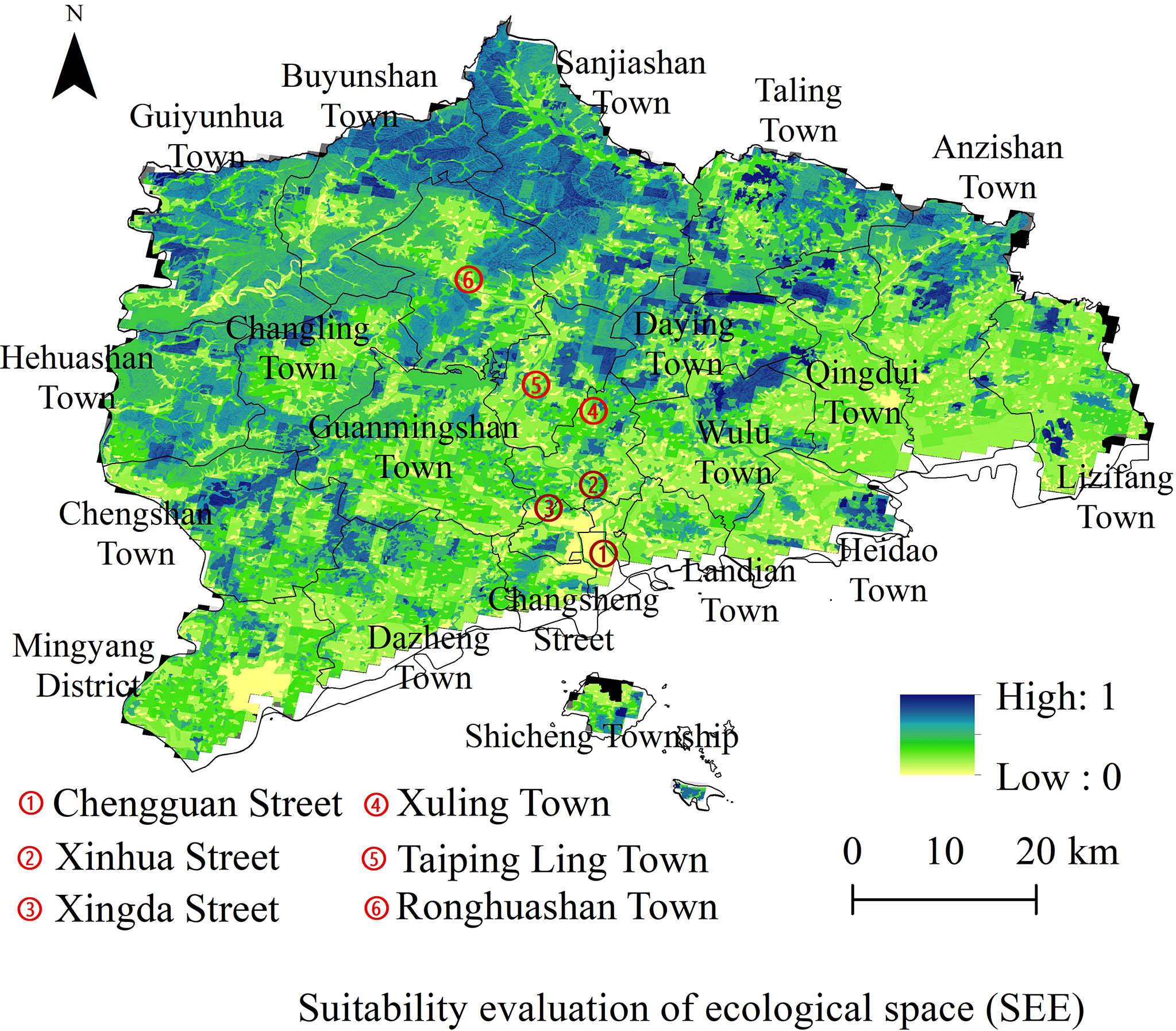
Figure 8 Evaluation of ecological space suitability.
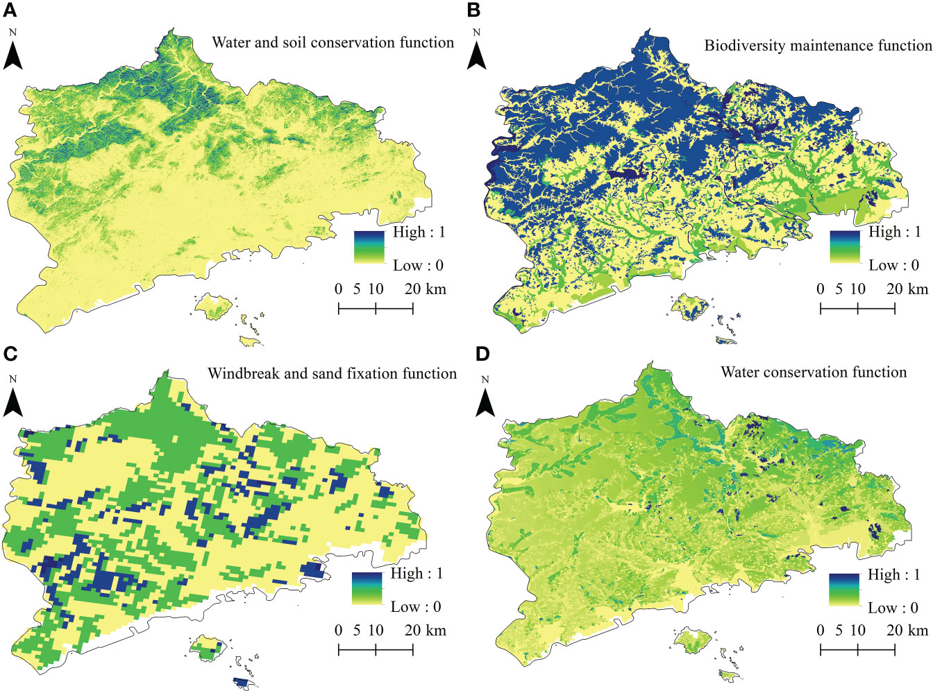
Figure 9 Ecological space suitability evaluation factors.
3.2.4 Suitability of coastal fishery production
The suitability evaluation of coastal fishery production is shown in Figure 10. Only a few high-value spaces for fishery production suitability were identified. The more suitable and suitable areas accounted for only 20.34 km2, mostly clustered in Changsheng Street and some sea areas of Dazheng Town. Fishery areas in coastal waters were identified in Qingduizi Bay, within 5 km of land, where the main area was related to reclamation. The less suitable space for fishery production was estimated to be ~2,248.14 km2, mainly concentrated in 10–20 m isobath sea areas. As discussed, there are many rivers in the study area. Thus, the primary productivity of the coastal waters was relatively high (Figures 11A, B). At the same time, marine protected areas and reserve areas were found to be large, accounting for more than 65%, thereby limiting the space for fishery production (Figures 11C, D).
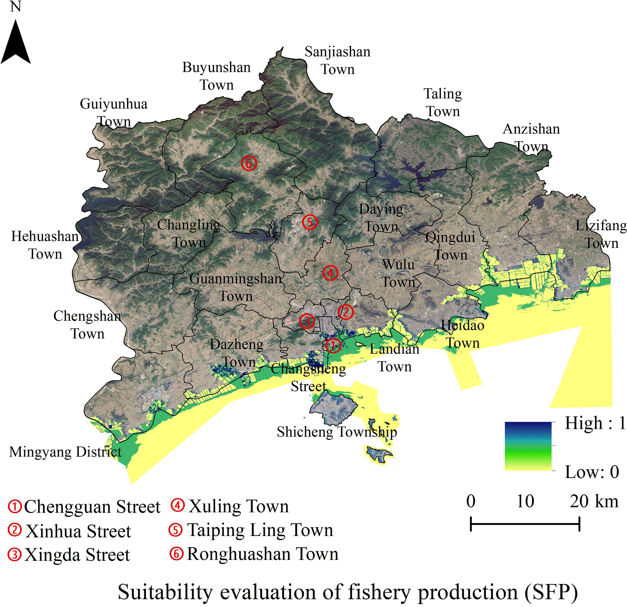
Figure 10 Suitability evaluation of fishery production.
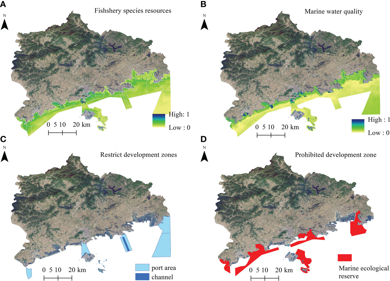
Figure 11 Evaluation factors of fishery production suitability.
3.2.5 Coastline function suitability
In general, the coastline suitability evaluation index considers the environmental carrying capacity, ecological protection needs, layout of coastal production space, and need for economic development according to the natural geography and actual development of the coastline (Chen et al., 2019). This implies that the ecological function of the coastline mainly considers factors such as marine functional area and ecological importance. At the same time, the living function of the coastline mainly considers the marine functional area and land development conditions. The production function of the coastline mainly considers the conditions of the coastline, marine functional area, waterways, and land development. Among these, land development conditions include socio-economic development level, traffic accessibility, and urban space, among others, while the ecological importance reflects coastal biodiversity conservation, maintenance of important ecosystems, and coastline erosion risks (Figure 12).
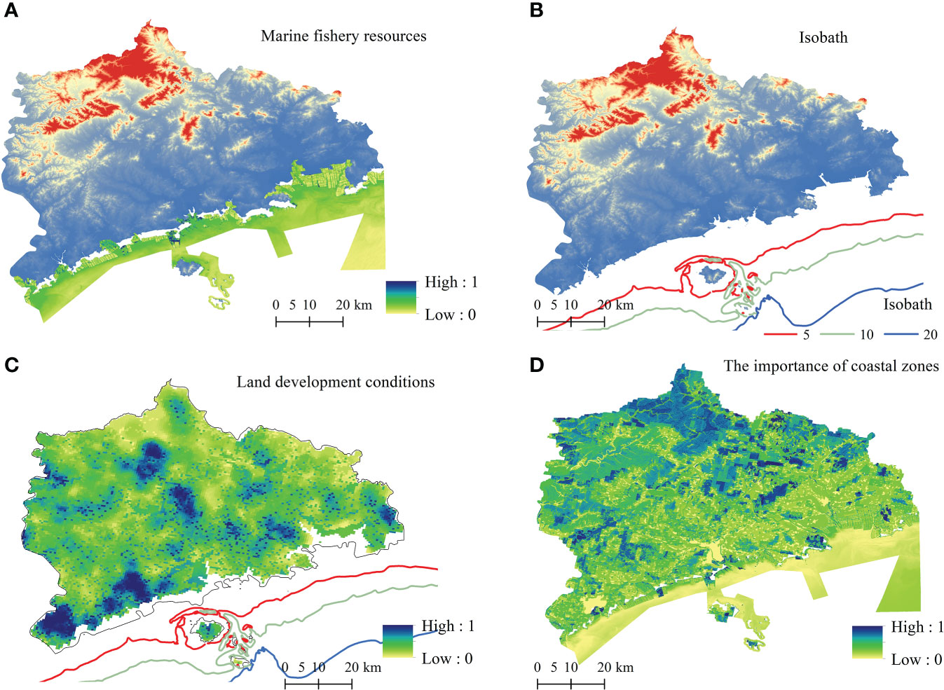
Figure 12 Evaluation indicators of coastline function suitability.
Various evaluation factors imply the existence of 8 types of marine functional utilization in Zhuanghe(Sea for fishery, sea for industry, sea for transportation, sea for tourism, sea for engineering construction, sea for sewage and dumping, sea for military use, and marine protected areas.). The development and utilization of sea areas were mainly represented by reserve areas, fish farming, urban sea use, and transportation. Furthermore, sea areas near Mingyang Street and Haiwang Island were marine protected areas (Figure 12A). The coastline of Zhuanghe City is generally flat, and the isobath range of 0–10m coastline was found to be ~10 km. The coast was dominated by low and gentle plains, and the seabed landform was represented by a shallow sea accumulation plain. Plains with low and gentle coasts account for more than 40%. Figure 12B illustrates that the geological environment was stable with a certain risk of seawater intrusion in the estuary area. In terms of development conditions, the land area of Zhuanghe was low and gentle, with a high identified development suitability and large differences in the face of different development needs (Figure 12C). For instance, the southern coastal area of Zhuanghe is characterised by concentrated population and industrial activities, and the development intensity is relatively high. Some coastlines were transformed into land through high-intensity development (artificial reclamation), and natural coastlines were transformed into artificial coastlines. The ecological environment was deemed to be fragile, thereby refuting the suitability for high strength development. The seabed landform is low and gentle with an estimated water depth of 4–10 m. As it is located at the estuary of the river, a risk of sediment deposition emerged, thereby lowering the suitability of ports and waterways. Lizifang Town, Qingdui Town, Dazheng Town, and other coastal towns were characterised by dense populations and concentrated industrial activities. Moreover, the urban development intensity of these areas was relatively high, thereby potentially facilitating coastal economic development activities.
Figure 12D illustrates the importance of the coastal zone. As seen, water quality in the offshore area was characterised by classes II and III, thereby implying that the water quality requirements of mariculture have been successfully met. However, given the high aquaculture density and excessive nutrients, in some areas, the water quality was inferior (class IV) and the environmental capacity was low (Table 5) (Sun, 2013; Cheng et al., 2019).
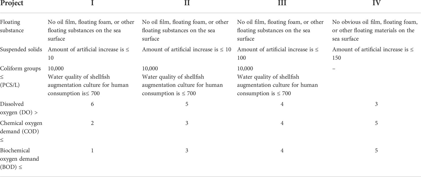
Table 5 Sea water quality standards (mg/L).
Figure 13 shows the evaluation results for coastline suitability. As seen, high-value areas of ecological coastline suitability in Zhuanghe City were clustered in the Shicheng Township (Shicheng Island, Haiwang Island) and the estuary of Biliu River. In this area, the distribution was somewhat relatively fragmented. Moreover, current coastline development is dominated by the natural coastline, with a total length of ~30.16 km (Figure 13A). The above-mentioned township sea areas were mainly represented by reserve areas and nature reserves. The capacity was found to be small, while anthropogenic activities affected the ecological environment less. In terms of life suitability, the Zhuanghe coastal land area is flat, and the life suitability was dominated by medium and high values (> 0.5). These values were mostly identified in Chengguan Street, Changsheng Street, and Heidao Town. Figure 13B illustrates that the above-mentioned areas exhibited a relatively high degree of development and utilization, a relatively concentrated population, complete infrastructure facilities, and high living suitability. In terms of the suitability of coastline production, given the influence of natural geographical features, the coastline of Zhuanghe City is mainly used for aquaculture, and the suitability of coastline production exceeded medium-to-high values. The length of the coastline is ~230.63 km (Figure 13C). With a relatively large water depth and good water quality, Zhuanghe City is an important producing area of precious seafood. It is characterised by complete fishery production infrastructure, strong industrial scale effect, and high suitability for coastline production.
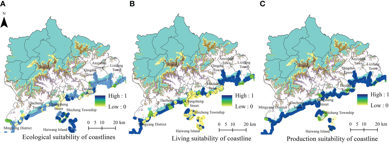
Figure 13 Suitability evaluation of the Zhuanghe coastline.
4 Conclusions
In this study, we developed an assessment framework of coastal zone territorial space resources, environmental carrying capacity, and spatial suitability from an integrated coastal zone management perspective. The superposition method was applied to evaluate the resource and environmental carrying capacity, as well as the suitability of Zhuanghe City.
First, it was found that the comprehensive carrying capacity of coastal resources and the environment were mainly critical, with large spatial differences. Of the analysed towns within the study area, only Changling Town was characterised by an overloaded land resource carrying capacity. Notably, most townships were found to be in a critical state. The marine resource carrying capacity analysis revealed high-value areas mostly in Dazheng Town and Mingyang Street in the southwest. Water resource carrying capacity analysis revealed a critical state. Only the water resource carrying capacity of the northwest mountainous area was in a bearable state, while some townships were affected by agricultural production and population agglomeration. Moreover, water resources were overloaded. The ecological carrying capacity was found to be in a critical state, while population and industrial agglomeration areas were both overloaded.
Second, although the development degrees of various types of land in the coastal zone of Zhuanghe City were mainly suitable, the suitability of different regional functional types differed substantially. More suitable construction areas for urban construction were mostly identified in the coastal plains and northern mountain valleys in the form of clusters, strips, or points, resulting in distinct spatial agglomeration. More suitable space for agricultural production accounted for ~50.51%, while unsuitable space for agricultural production was concentrated in the northern mountainous area. Ecological space suitability was mainly general, being concentrated in the central and eastern plains; its total area was ~3,487.17 km2. High suitability ecological space accounted for 14.17%, and was concentrated in the northern mountainous area. High-value space of fishery production suitability in the sea area was weaker, while more suitable and suitable areas accounted for only 20.34 km2.
Lastly, suitable coastlines for production, living, and ecological functions exhibited complex interplays. The development and utilization of the coastline and ecological restoration all face great challenges. The length of the coastline above the ecologically suitable level in Zhuanghe City was found to be 30.16 km, while the length of the coastline with high value for life suitability was ~15.71 km. The production suitability of the coastline was deemed to be above medium-to-high values, while the length of the coastline was ~230.63 km.
5 Discussion
China has gradually implemented the so-called “five level, three types” of territorial space planning system (Fan, 2019). In this approach, city, county, and township levels of territorial space planning all ensure that local development needs are met, while also deepening our understanding of regional nature and offering the possibility for ecological strategies. However, fundamental research on China’s coastal zone planning is lagging behind the management practices and objective demands. For both land and sea, major problems include an incomplete understanding of the interplay between local ecosystems to understudied coastal zone development characteristics, poorly understood ecological characteristics, and differences between the land and sea. Comprehensive coastal zone management should ideally rely on objective information, including that regarding the unique characteristics of the local ecosystem. Moreover, it is essential to coordinate land and sea development, thereby improving the efficiency of the regional governance system of land and sea.
In this context, the results of our study complement existing knowledge (e.g., theoretical basis), while promoting data-driven expertise based on empirical research in the Zhuanghe coastal zone. The national spatial planning practice and realistic requirements of coastal zone management will benefit from these findings. Future studies should consider a county-level administrative unit as the study area to take into account both the local environment and development, increase the ocean element and coastline of evaluation indices, and evaluate the construction of the coastal zone space framework. Such future analyses would unravel the drivers behind the contradiction between spatial development and protection in coastal zones. Overall, we proposed the following space optimization, “ecological line potential, and layout optimization” strategies for the Zhuanghe City coastal zone. First, coastal zone space development should prioritize regional ecological environment protection by considering the resource and environmental bearing capacity, the land and sea ecosystem stability maintenance, the key resource of water, and relic species preservation. Second, the three-dimensional development of marine space resources, and of marine, sea, seabed, and other marine economic layouts should be evaluated from the near shore to the open sea to relieve pressure from the ecological environment of the near shore. Third, the land use type adjustment, marine function adjustment, and the spatial reserve of the coastal zone should be considered and optimised. In this way, the contradictions between terrestrial ecological space and agricultural space should be alleviated. The marine breeding space and port space, marine and land production coastline, living coastline, ecological coastline, and production coastline should all be addressed at the micro-scale, thereby elucidating previously unidentified processes and drivers.
It should be noted that the same space can serve multiple functions. Although the diversity and representativeness of evaluation factors were considered in this study, the integrated results of suitability evaluation mainly imply single spatial functions. Moreover, some indicators were retrieved based on remote sensing observations and inventory analyses, while the visualization results were obtained by the spatial interpolation method. Both approaches need to be further improved in future studies to maximize their accuracy. As a concluding remark, this study considered the coastal zone space as a closed medium, neglecting the mobility of the marine environment and resource elements. To this end, future studies should elucidate the influence of mobile elements on the coastal zone space.
Data availability statement
The original contributions presented in the study are included in the article/supplementary material. Further inquiries can be directed to the corresponding author.
Author contributions
SY: Data Curation, Formal Analysis, Investigation, Methodology, Visualization, Writing – Original Draft Preparation, Writing – Review and Editing. ZH: Conceptualization, Funding Acquisition, Methodology, Project Administration, Resources, Writing – Review and Editing. JG: Project Administration, Resources, Writing – Review and Editing. All authors contributed to the article and approved the submitted version.
Funding
This material is partially based upon work supported by the National Science Foundation (Grant No. 41976206).
Acknowledgments
We would like to thank Editage (www.editage.cn) for English language editing.
Conflict of interest
The authors declare that the research was conducted in the absence of any commercial or financial relationships that could be construed as a potential conflict of interest.
Publisher’s note
All claims expressed in this article are solely those of the authors and do not necessarily represent those of their affiliated organizations, or those of the publisher, the editors and the reviewers. Any product that may be evaluated in this article, or claim that may be made by its manufacturer, is not guaranteed or endorsed by the publisher.
Author disclaimer
Any opinions, findings, conclusions, and recommendations expressed in this material are those of the author and do not necessarily reflect the views of the National Science Foundation.
References
Cantasano N., Pellicone G., Ietto F. (2017). Integrated coastal zone management in Italy: A gap between science and policy. J. Coast. Conserv. 21 (3) 317–325. doi: 10.1007/s11852-016-0479-z
Carlotta S. (2018). 4. one Sea, one humanity. modeling the man-Sea relationship in Friedrich ratzel’s anthropogeographical project. J. Interdiscip. History Ideas 6 (12), 1–24. doi: 10.13135/2280-8574/2543
Caviedes V., Arenas G. P., Barragán M. J. M. (2022). Integrated coastal zone management on a transnational area: The gulf of Honduras. Mar. Policy 136, 104931. doi: 10.1016/j.marpol.2021.104931
Caviedes V., Pedro A. G., Juan M. B. (2020). Regional public policy for integrated coastal zone management in central America[J]. Ocean Coast. Manage. 186 (C), 105114. doi: 10.1016/j.ocecoaman.2020.105114
Chen C. (2017). Coastal tidal flat development mode choice and spatial configuration of different functional areas in nantong coastal zones. Scientia Geographica Sin. 37 (1), 138–147. doi: 10.13249/j.cnki.sgs.2017.01.017
Cheng C., Liu Y. L., Chen Y. Y., Liu Y. F., Zhang Y., Shen S. S., et al. (2019). Diagnosing cropland's allowable range and spatial allocation in china's typical mountainous plateau area: An evaluation framework based on ecological carrying capacity. Sci. Total Environ. 685 (C), 1255–1268. doi: 10.1016/j.scitotenv.2019.03.200
Di Q. B., Han Z. L., Sun C. Z. (2008). Research on sea area carrying capacity theory and marine sustainable development. Ocean Dev. Manage. 01), 52–55.
Dina S., Abeer A. E. K. (2021). Problematic soil risk assessment approach for sustainable spatial suitability of urban land use in new cities by using GIS and remote sensing: A case study of new East port said city. IJSDP 16 (4), 615–628. doi: 10.18280/ijsdp.160402
Fan J. (2019). Spatial organization pathway for territorial function-structure:Discussion on implementation of major function zoning strategy in territorial spatial planning. Geographical Res. 38 (10), 2373–2387. doi: 10.11821/dlyj020190865
García S. J. (2015). Integrated coastal zone management: A public policy. the need for communication, coordination and participation. J. Coast. Zone Manage. 18 (3), 1–2. doi: 10.4172/jczm.1000e113
Han Y., Wei F. Y., Ye G. Q., Yang S. Y., Ma P. P., Hu W. J. (2018). A study on evaluation the marine carrying capacity in guangxi province, China. Mar. Policy 91, 66–74. doi: 10.1016/j.marpol.2018.02.003
Hietala R., Ijäs A., Pikner T., Kull A., Printsmann A., Kuusik M., et al. (2021). Data integration and participatory process in developing integrated coastal zone management (ICZM) in the northern Baltic Sea. J. Coast. Conserv. 25 (5), 47. doi: 10.1007/s11852-021-00833-4
IBM SPSS software. Available at: https://www.ibm.com/analytics/spss-statistics-softwarehttps://zrzy.dl.gov.cn/.
Kuang W. H. (2019). Issues regarding spatial pattern change of national land space and its overall implementation on beautiful vision in new era. Resour. Sci. 41 (1), 23–32. doi: 10.18402/resci.2019.01.03
Li J. L., Tian P., Li C. D. (2022). Land-sea economic relations and land spaceutilization based on land-sea coordination: research status, problems and future priorities. J. Natural Resour. 37 (04), 924–941. doi: 10.31497/zrzyxb.20220407
Li K. Y., Jin X. L., Ma D. X., Jiang P. H. (2019). Evaluation of resource and environmental carrying capacity of china’s rapid-urbanization areas–a case study of xinbei district, changzhou. Land 8 (4), 69. doi: 10.3390/land8040069
Lin G., Fu J. Y., Jiang D. (2021). Production–Living–Ecological conflict identification using a multiscale integration model based on spatial suitability analysis and sustainable development evaluation: A case study of ningbo, China. Land 10 (4), 383. doi: 10.3390/land10040383
Ministry of housing and urban-rural development of the people’s republic of China, unified standard for civil building design (GB 50352-2019 (2019). Available at: https://www.mohurd.gov.cn/gongkai/fdzdgknr/tzgg/201905/20190530_240715.html.
Nawel K., Mohamed L., Samir G., Iwan L. B., Ingrid P. (2019). Challenges and opportunities in promoting integrated coastal zone management in Algeria: Demonstration from the Algiers coast. Ocean Coast. Manage. 168, 185–196. doi: 10.1016/j.ocecoaman.2018.11.001
Pasquali D., Marucci A. (2021). The effects of urban and economic development on coastal zone management. Sustainability 13 (11), 1–18. doi: 10.3390/su13116071
Ren W. H., Ji J. Y., Chen L., Zhang Y. (2018). Evaluation of china's marine economic efficiency under environmental constraints–an empirical analysis of china's eleven coastal regions. J. Cleaner Production 184, 806–814. doi: 10.1016/j.jclepro.2018.02.300
Rong Q. Q., Cai Y. P., Su M. R., Yue W. C., Dang Z., Yang Z. F. (2019). Identification of the optimal agricultural structure and population size in a reservoir watershed based on the water ecological carrying capacity under uncertainty. J. Cleaner Production 234, 806–814. doi: 10.1016/j.jclepro.2019.06.179
Schipper C. A., Gerben G. J. D., Beer V., Bas B., Quirijn L. (2021). Characterization of SDGs towards coastal management: Sustainability performance and cross-linking consequences. Sustainability 13 (3), 1560. doi: 10.3390/su13031560
Shannon C. E. (1948). A mathematical theory of communication. Bell System Tech. Journal[J] 27 (3), 623–656. doi: 10.1002/j.1538-7305.1948.tb01338.x
Shen L., Shu T., Liao X., Yang N., Ren Y., Zhu M., et al. (2020). A new method to evaluate urban resources environment carrying capacity from the load-and-carrier perspective [J]. Resour. Conserv. Recycl. 154, 104616. doi: 10.1016/j.resconrec.2019.104616
Su H. F., Cao G. R., Gu C. L., Jin J. L., Zhang X. M., Yi H. L., et al. (2020). The superior agricultural space demarcation based on the evaluation of resources and environmental carrying capacity and territorial spatial development suitability at municipality and county levels: Theories, methods and study of two cases. J. Natural Resour. 35 (08), 1839–1852. doi: 10.31497/zrzyxb.20200807
Sun W., Chen C. (2013). Spatial function regionalization and spatial governance of the coastal zone: A case study in ningbo city. Geographical Res. 32 (10), 1878–1889. doi: 10.11821/dlyj201310011
Tang C. C., Fan J., Chen X. L. (2012). Analysis of land utilization coordination based on territorial function–a case study of muyun town of changsha-Zhuzhou-Xiangtan ecological green heart. J. Natural Resour. 27 (10), 1645–1655.
Tang C. C., Xing Z., Lei J. J., Sun W. M. (2022). Characteristics and formation mechanism of urban-rural multidimensional spatial conflict in metropolitan Fringe:Take zhuanxi village in shaoguan city as an example. Economic Geogr. 42 (01), 79–89. doi: 10.15957/j.cnki.jjdl.2022.01.010
Ta B. L., Thi T. D. L. (2022). Assessing marine environmental carrying capacity in semi-enclosed coastal areas - models and related databases. Sci. total Environ. 838 (P1), 156043. doi: 10.1016/J.SCITOTENV.2022.156043
Theodora Y., Spanogianni E. (2022). Assessing coastal urban sprawl in the athens’ southern waterfront for reaching sustainability and resilience objectives. Ocean Coast. Manage. 222, 106090. doi: 10.1016/j.ocecoaman.2022.106090
Tian R. Q., Shao Q. L., Wu F. L. (2020). Four-dimensional evaluation and forecasting of marine carrying capacity in China: Empirical analysis based on the entropy method and grey verhulst model. Mar. Pollut. Bull. 160, 111675. doi: 10.1016/j.marpolbul.2020.111675
Victor T. C. L. (2018). The analysis of maintaining biodiversity, integrated coastal zone management and environmental impact assessment for marine spatial planning. J. Mar. Science: Res. Dev. 8 (5), 1000260. doi: 10.4172/2155-9910.1000260
Wang P. L., Wei Y., Zhong F. L., Song X. Y., Wang B., Wang Q. H. (2022). Evaluation of agricultural water resources carrying capacity and its influencing factors: A case study of townships in the arid region of Northwest China. Agriculture 12 (5), 700. doi: 10.3390/AGRICULTURE12050700
Wu T., Yue W. Z., Xia H. X., Xiong J. H. (2022). Optimization of major function zoning strategy from the perspective of territorial spatial planning. Economic Geogr. 42 (02), 11–17+73. doi: 10.15957/j.cnki.jjdl.2022.02.002
Yu Z. L., Zhang W. X., Liang J. S., Zhuang L. (2015). Progress in evaluating suitability of spatial development and construction land. Prog. Geogr. 34 (09), 1107–1122. doi: 10.18306/dlkxjz.2015.09.004
Keywords: coastal zone, resource and environmental carrying capacity, spatial suitability, integrated coastal zone management, Zhuanghe
Citation: Yin S, Guo J and Han Z (2022) County-level environmental carrying capacity and spatial suitability of coastal resources: A case study of Zhuanghe, China. Front. Mar. Sci. 9:1022382. doi: 10.3389/fmars.2022.1022382
Received: 19 August 2022; Accepted: 10 October 2022;
Published: 24 October 2022.
Edited by:
Juan Jose Munoz-Perez, University of Cádiz, SpainReviewed by:
Catalin Anton, Dunarea de Jos University, RomaniaAbdelazim Negm, Zagazig University, Egypt
Evelia Rivera-Arriaga, Universidad Autónoma de Campeche, Mexico
Copyright © 2022 Yin, Guo and Han. This is an open-access article distributed under the terms of the Creative Commons Attribution License (CC BY). The use, distribution or reproduction in other forums is permitted, provided the original author(s) and the copyright owner(s) are credited and that the original publication in this journal is cited, in accordance with accepted academic practice. No use, distribution or reproduction is permitted which does not comply with these terms.
*Correspondence: Shusheng Yin, eWluc2h1c2hlbmcwMUBnbWFpbC5jb20=