 Pedro S. Menandro
 Ana Carolina Lavagnino
 Fernanda V. Vieira
 Geandré C. BoniTarcila Franco
 Alex C. Bastos*
- Marine Geosciences Lab, Departamento de Oceanografia e Ecologia, Universidade Federal do Espírito Santo, Vitória, Brazil
Seabed mapping is currently the baseline information for ocean management and conservation, and is an indispensable item within research and Marine Spatial Planning. Here, we use a case study and published data along the southeast Brazilian continental shelf to illustrate the concepts and ideas of potential benthic habitat mapping and the importance of having maps on different scales and the potential for using a multi-design approach. The case analysis presented here uses a regional map and distinct criteria (seabed geodiversity and biodiversity, and potential influence of a tailings plume) to define three areas along the continental shelf to be mapped in a high-resolution, as part of a marine monitoring program. The background of the case study is a tailing dam failure disaster that led to the input of iron ore tailings in the ocean, leading to a major environmental disaster. Three areas were chosen, including: a Marine Protected Area (MPA Costa das Algas), a major fishing ground (the Doce River prodelta/depocenter), and an understudied reef area (Forgotten Reefs). Potential benthic habitat mapping was carried out using acoustic surveys (multibeam echosounder acquiring bathymetry and backscatter) and ground-truthing (sediment samples and seafloor image). Results detailed the potential habitats throughout the three areas, providing primary information for the study of benthic habitats and their distribution. The multi-design approach indicated that although a regional analysis can indicate potential vulnerability as a first assessment approach, high-resolution potential habitat mapping (herein, 20 m or finer) is beneficial to evaluate and produce a higher-confidence level for decision-makers. Having an overall view of what and where to collect new and finer data would be best to identify vulnerable areas that, in this case study, could be threatened by plume dispersion and tailings accumulation. Our results support the delineation of priority areas aiming for monitoring, protection and guiding for other studies, besides the consolidation of habitat importance and the integration of various datasets through a hierarchical classification scheme. Although Brazil has never produced a regional or national habitat map for the entire continental margin, there are already conditions to plan, execute and maintain a habitat mapping program, partnering with Universities, Government Institutions (e.g., the Brazilian Navy), and the private sector. In the context of the UN Decade of Ocean Science targets, it is urgent to plan and implement a national database capable of supporting a habitat classification effort on a broader national scale, with the flexibility to support a multi-design or a multi-scale approach.
1 Introduction
Seabed mapping is currently the baseline information for ocean management and conservation, and has become an indispensable tool within research and Marine Spatial Planning - hereafter MSP (Brown et al., 2012; Novaczek et al., 2017; Strong et al., 2019). The investment in technology, science, and research, along with international demands, such as the expansion of human activity within Exclusive Economic Zone, marine resources, and renewable energy exploration, has been enhancing a seabed morphology view and contributing to a better understanding of our ocean.
The acquisition of bathymetry data has had as primary goal the safety of navigation. Now it is commonly used in MSP applications combined with its derivatives and backscatter intensity, which can be applied in conjunction to characterize the seafloor morphology and substrate in greater detail. Seabed morphology can be used as a proxy along with ground-truthing to identify marine habitats utilizing diverse classification techniques involving visual interpretation, algorithms, statistical correlation, machine/deep learning, and others (Lecours et al., 2016; Diesing et al., 2020), contributing to ecosystem-based management and MSP in general (Heyman and Wright, 2011; Long et al., 2015).
The idea of habitat mapping lies in the fact that abiotic variables, including seabed and water column characteristics, can be used as surrogates for the presence and distribution of benthic communities (Brown et al., 2011; Harris and Baker, 2020). Seabed mapping research provides relevant information, such as sediment type and composition, terrain attributes (slope, roughness, etc), and water depth among others, that can influence or determine the distribution and occurrence of distinct benthic communities. Properties such as backscatter and terrain attributes derived from bathymetry are routinely applied due to their potential as surrogates for ecological patterns (Harris, 2012). In this context, seabed mapping and benthic habitat distribution provides a baseline useful for government and other stakeholders to evaluate and understand the potential ecosystem vulnerability and environmental impacts on marine biodiversity (Brown et al., 2012; Novaczek et al., 2017). Moreover, benthic habitat maps play a major role in cases of specific anthropogenic or natural threats such as dam failure, seabed litter, bottom trawling, climate changes, tropical storms, etc (Buhl-Mortensen and Buhl-Mortensen, 2018; Lacharité and Brown, 2019; Goodman et al., 2020).
Benthic habitats increasingly suffer from anthropogenic impacts (Harris, 2012) that might alter their ecosystem and biodiversity (Cook et al., 2013). In this case, habitat maps provide information to assess whether an area has been or has not been affected by any impact, either anthropogenic or natural (Harris, 2012). One limitation is that the lack of pristine habitats to serve as a baseline might impose a challenge for assessing impacts (Harris, 2012). Moreover, the same knowledge is a fundamental tool to monitor and understand the influence of climate changes on marine habitats.
In this context, potential or actual habitat (Greene et al., 2007), biotope (Buhl-Mortensen et al., 2020), and benthoscape (Brown et al., 2012; Proudfoot et al., 2020) ended up being part of distinct marine habitat approaches which can involve different spatial scales. Inherently, benthic habitat mapping will be scale-dependent, since the processes that define habitat distribution also act in different temporal and spatial scales. Thus, scale is a critical aspect of habitat mapping, and the lack of understanding about appropriateness and influence of resolution may lead to misinterpretation and inadequate decision making (Greene et al., 2007). Mapping scale should be directly related to the main objectives and tasks, but is often management-dependent (Brown et al., 2012). High-resolution seabed mapping based a variety of seafloor characteristics is more suitable for conservation and protection plans (Harris et al., 2008). However, depending on management requirements and funds, scale analysis reduction may take place (Brown et al., 2012).
We present a case study and published data along the Brazilian continental margin to illustrate the concepts and ideas of potential benthic habitat mapping and the importance of having maps at different scales, or, which is more appropriate in this case, a multi-design approach. The choice to use the term multi-design rather than multi-scale is based on the fact that different approaches and methods, with different resolutions, were used to produce the final results. The multi-design approach was demanded due to a major man-induced disaster caused by a tailing dam failure that released 39 million cubic meters of iron ore tailings in the Doce river basin, SE Brazil. Tailings reached the Doce river mouth (Western South Atlantic Ocean) as a high-concentrated mud plume that was deposited and dispersed along the Espírito Santo - Abrolhos Continental Shelf (ESACS) (Quaresma et al., 2020). The case study presented here starts with an existing regional mapping approach used to define priority areas in the ESACS for detailed mapping. Benthic habitat mapping was carried out in three specific areas using acoustic surveys (multibeam echosounder acquiring bathymetry and backscatter) and ground-truthing (samples and seafloor images). No specific analysis of the associated biota (species or community) was carried out for this study.
This study presents the application of potential benthic habitat mapping to support decision-makers in the case of anthropogenic disasters, when emergency plans must be put into action, especially environmental monitoring programs. We aim to discuss the influence of producing high-resolution benthic habitat maps in combination with regional maps. The multi-design approach of the paper has to do not only with the use of regional, less detailed maps, serving as a baseline of the area to be mapped at a higher resolution, but also as a contribution to a vulnerability ecosystem approach. Moreover, the multi-design approach proposed provided information to infer the appropriateness and applicability of different scales for different objectives, although defining the best scale is beyond the scope of this work. We also aim to use this case study analysis to discuss further the importance of seabed mapping to improve the Brazilian Policy for MSP and Environmental Studies in the context of the United Nations Decade of Ocean Science for Sustainable Development.
2 Methods
2.1 Study area and the Fundão tailing dam failure
The study area is presented in Figure 1. The shelf presents a terrigenous-carbonate mixed sedimentation regime, with significant morphological contrasts, characterized by the spatial variability influence of riverine sediment input and carbonate production (Bastos et al., 2015). The main riverine sediment input to the shelf is associated with the Doce river, which is the 5th largest Brazilian watershed, and one of the four wave-dominated deltas (Dominguez, 2004) along the eastern Brazilian coast. The Doce River suspended sediment load input during the wet season can reach up to 1.8 x 10⁶ tons/day (Oliveira and da Silva Quaresma, 2017). On November 5th, 2015, the collapse of the Fundão tailing dam, located in Mariana (MG, Brazil), released around 39.2 million m³ of iron ore mining waste into the Doce river watershed. Tailings were mainly composed of iron-rich minerals and quartz, so they were toxic to the environment. A high-concentration mud suspension traveled 660 km reaching the eastern Brazilian coast in 14 days. Lack of management in the dam drainage system was pointed out as the cause of the structural failure. In general, the major initial impact caused by the tailing dam failure was the burial of several sectors of small drainages and along the Doce River. In coastal and marine areas, burial was not the major impact. Dissolved and particulate iron and several heavy metals contents caused the major environmental impact.
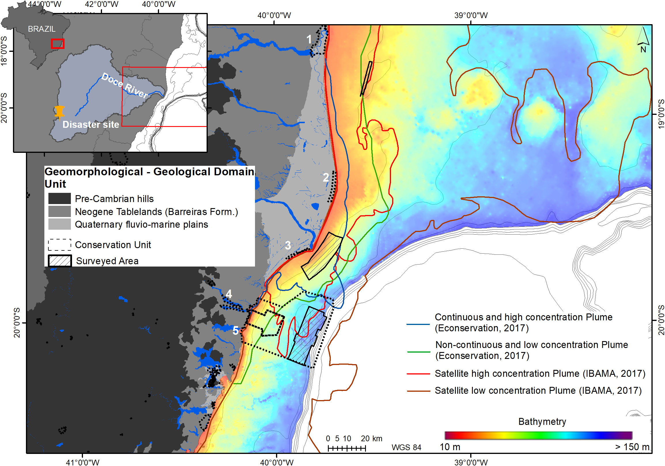
Figure 1 Bathymetric map (grid spacing of 100 m) of the study area showing: surveyed habitat mapping areas; distribution of Conservation Units (1- Marine Protected Area Conceição da Barra; 2 - Degredo Area of Relevant Ecological Interest; 3 - Biological Reserve of Comboios; 4- Municipal Sustainable Development Reserve (RDS) Piraquê-açu and Piraquê-Mirim; 5 - Wildlife Reserve Santa Cruz/Marine Protected Area Costa das Algas; and compilations of the maximum riverine plume contour based on direct helicopter observation (Econservation, 2017) and satellite image (IBAMA (Instituto Brasileiro do Meio Ambiente e dos Recursos Naturais Renováveis), 2017) for the first two years after the dam failure.
This disaster led to a variety of social, economic, and environmental impacts: 19 people died, several villages were partially destroyed, families were displaced, freshwater, fisheries, agriculture, and tourism were disrupted, tons of fish suffocated and the effects on terrestrial and freshwater aquatic habitats were observed throughout the entire watershed (Fernandes et al., 2016). The first results in the estuarine and marine areas showed that a high concentration plume reached the inner shelf leading to a sedimentation rate of up to 5 cm in the first week (Quaresma et al., 2020). Acute and chronic impacts on biodiversity were reported in planktonic and benthic communities (Bernardino et al., 2019; Fernandes et al., 2020). Shelf sediments presented an immediate increase in clay content affecting settling rates and increasing the potential for sediment resuspension and dispersion (Grilo et al., 2018; Quaresma et al., 2020).
Remote sensing analysis and helicopter flight direct observation of the tailing plume in the coastal and marine areas were carried out by Federal and State Environmental Agencies. Their results suggest that the tailing plume dispersed and traveled more than 100km northward and southward of the river mouth, and could have affected an area larger than 3,000 km2 (Lobban and Harrison, 1994; Liu et al., 2001; Janssen et al., 2006; Lecours et al., 2015; Long et al., 2015; Le Bas, 2016; Lecours et al., 2016; Econservation, 2017; IBAMA (Instituto Brasileiro do Meio Ambiente e dos Recursos Naturais Renováveis), 2017; Lecours, 2017; Innangi et al., 2019; Kaskela et al., 2019; Lacharité and Brown, 2019; Lavagnino et al., 2020; Lucatelli et al., 2020; Longhini et al., 2022-Figure 1). Modeling studies also considered that the plume could have affected a coastal area as far as 200 to 300 km from the river mouth and reached beyond the shelf break (Magris et al., 2019). However, there is still a broad discussion and controversy regarding the plume dispersion and the affected area (Rudorff et al., 2018).
The results presented here are part of the Aquatic Biodiversity Monitoring Program (ABMP), which is partially executed by an academic network (Rede Rio Doce Mar-RRDM) with researchers from 27 institutions. The ABMP is the official Monitoring Program established in the Conduct Adjustment Term (TAC) signed by Federal and State Governments and the mining companies involved in the disaster (Samarco, Vale, and BHP Billiton). The TAC created the Renova Foundation, responsible for managing and executing all the programs defined in the signed agreement, and a Public/Federal/State Committee that supervises, validates, and approves the activities and acts conducted by the Renova Foundation. The ABMP was implemented to ensure that the impact caused by the disaster could be quantified and actions could be taken. Although several random and isolated actions were conducted to monitor the marine environment since November 2015, the official and complete monitoring program was not initiated until June 2018. The ABMP consists of temporal and spatial analysis of water and sediment quality, ecotoxicology, ecological effects in benthic, plankton, and ichthyofauna communities, among others, and the implementation of habitat mapping.
2.2 Benthic habitat mapping
The impact caused by the dam failure and the tailings input to the ocean led to the decision to apply a multi-design approach for the mapping of benthic habitat distribution. The multi-design approach consists in using available regional maps (bathymetry, sedimentary facies, potential habitats) in order to define specific sites to carry out a high-resolution (multibeam based) habitat mapping study.
2.2.1 Site selection based on regional habitat mapping
Considering the extensive area that was potentially affected by the tailings plume dispersion, it was not possible to map the entire continental shelf in high resolution. Thus, specific areas had to be defined and surveyed as part of the ABMP. To define these areas, and taking into account time and cost limitations, we used a simple qualitative ecosystem-based approach considering the regional physical and ecological attributes (geodiversity and seascape ecology), hydrodynamics associated with the environmental impact, and the main marine activities over the area.
The selection of the three areas considered the habitat’s features (physical and ecological settings), and anthropogenic and natural threats (focused on ones directly associated with the tailings dam failure). The selection approach used a GIS overlap of spatial information (habitats and potential threats), and a combination of empirical data and expert knowledge (Nelson and Burnside, 2019). Regional environmental layers comprise existing/available physical datasets (bathymetry, sediment distribution, derived terrains attributes) and known regional benthic habitats of most ecological significance (rhodolith beds and reefs). Marine activities were considered here as the most potential activities affected by the disaster, i.e., recreational (beach resorts, etc), fisheries, and existing marine protected areas (MPA). It is important to note that all the available regional maps were produced as part of other studies conducted by the same research group (Marine Geosciences Lab-UFES) along the ESACS.
Figure 2 presents the four main maps used in our analysis to select specific areas for a higher resolution mapping. According to Bastos et al. (2015), the ESACS presents three main morphological sectors directly related to sedimentary regime domains: the Abrolhos Shelf, the Doce river Shelf, and the Paleovalley Shelf. The Abrolhos shelf presents a major width enlargement with mixed sediments along the coast, submerged reefs, rhodolith beds, and carbonate sediments along the inner and outer shelf. The Doce river Shelf receives a major riverine sediment input, associated with a regular and lobate seabed morphology, while the Paleovalley Shelf is characterized by a very irregular morphology and dominated by carbonate sedimentation, including extensive rhodolith beds and submerged reefs along the margin and flank of the paleovalleys (Vieira et al., 2019, Holz et al., 2020; Oliveira et al., 2020).
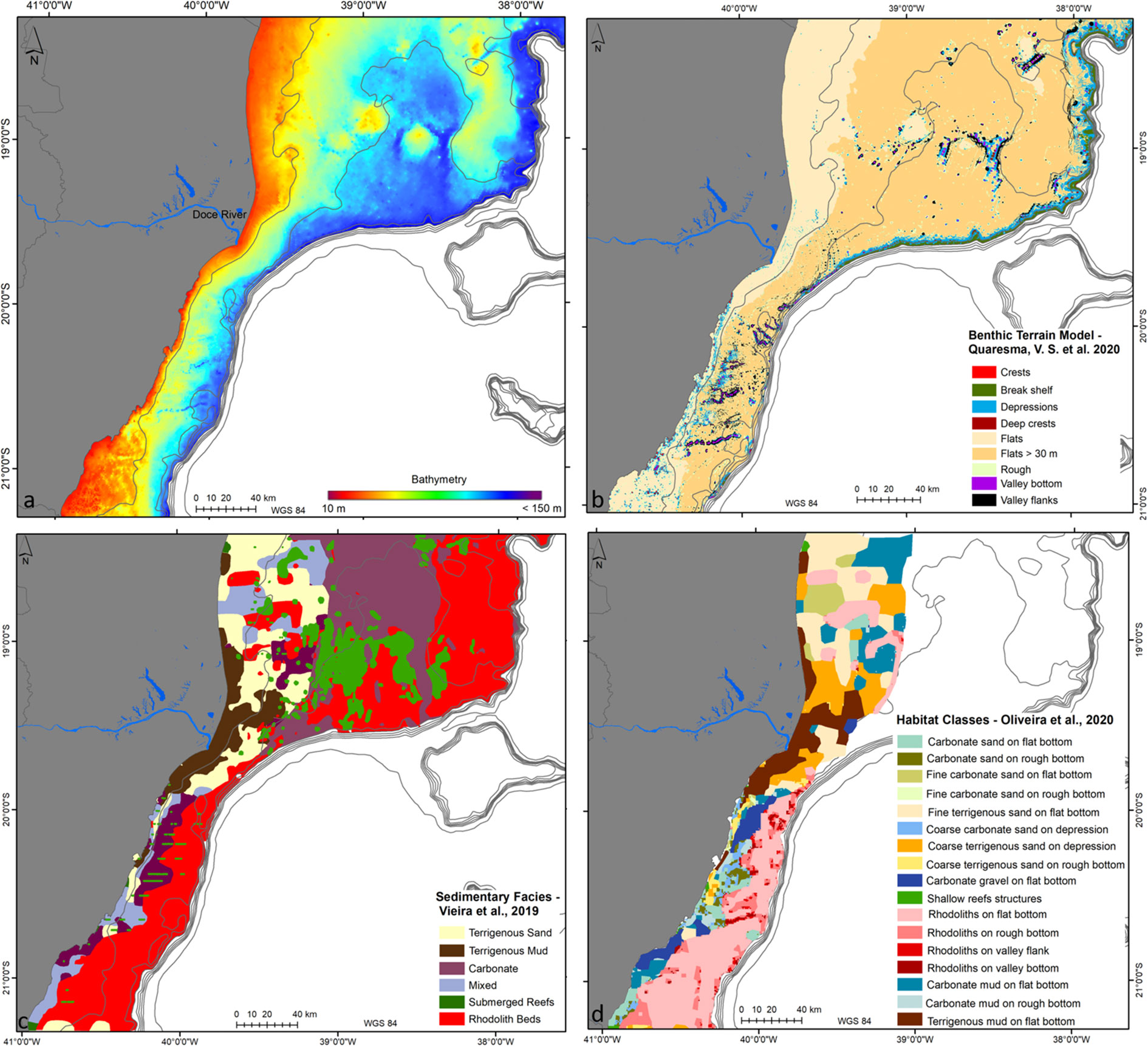
Figure 2 Maps showing the available Regional environmental layers used to define the high-resolution habitat mapping areas: (A) Bathymetry (grid spacing of 100m); (B) Benthic Terrain Model (each pixel with 100 m x 100m); (C) Sedimentary Facies (variable resolution between 1 km and 20 km); and (D) Habitat Classes (no resolution nor accuracy provided for the combined output).
The regional benthic terrain model (BTM) map (Figure 2B; Quaresma et al., 2020) extracts the major differences in seabed morphology and highlights areas that are dominated by crests, depressions, steep areas, and flat beds. BTM class definition is based on combined terrain attributes, such as the Bathymetric Position Index (BPI), Slope, and Water Depth. The number of BTM classes can depict areas showing a higher degree of morphological complexity, indicating a higher geodiversity which is a potential indicator of an area supporting higher biodiversity (Pittman et al., 2021). The seabed sediment distribution map – Figure 2C – (Vieira et al., 2019) shows a combination of terrigenous and carbonate sedimentation regimes. Highlights are the extensive rhodolith bed covering most of the outer shelf along the entire ESACS (also described by Amado-Filho et al., 2012 and Moura et al., 2013), the presence of submerged reefs along the inner and outer shelf, and the terrigenous sedimentation (mud deposit) adjacent to the Doce river mouth. Oliveira et al. (2020) combined the sediment distribution and the BTM classes to produce a physical potential habitat map on a regional scale – Figure 2D.
Local and regional aspects of habitat features, and anthropogenic and natural threats were analyzed based on empirical data and expert knowledge (e.g., Bastos et al., 2015; Quaresma et al., 2015; Bourguignon et al., 2018; Vieira et al., 2019; Holz et al., 2020; Oliveira et al., 2020, Oliveira et al., 2021; Quaresma et al., 2021). The objective was to assess the potential threats over the regional habitat map and then select an area for a high-resolution benthic habitat map. Based on the joint analysis (habitat + threats) summarized in Table 1, the three chosen areas (Figure 3) to map with details are the MPA Costa das Algas, the Doce river inner shelf, and the Forgotten Reefs (Recifes Esquecidos).
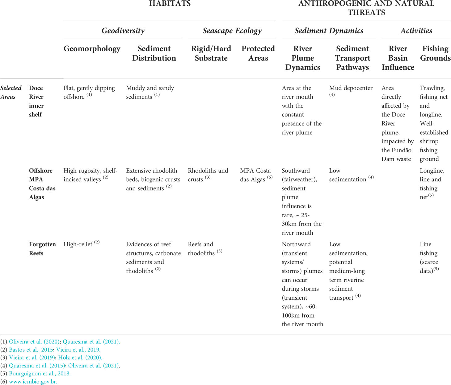
Table 1 Description of local and regional aspects of the Habitat and Anthropogenic/Natural Threat for each selected area.
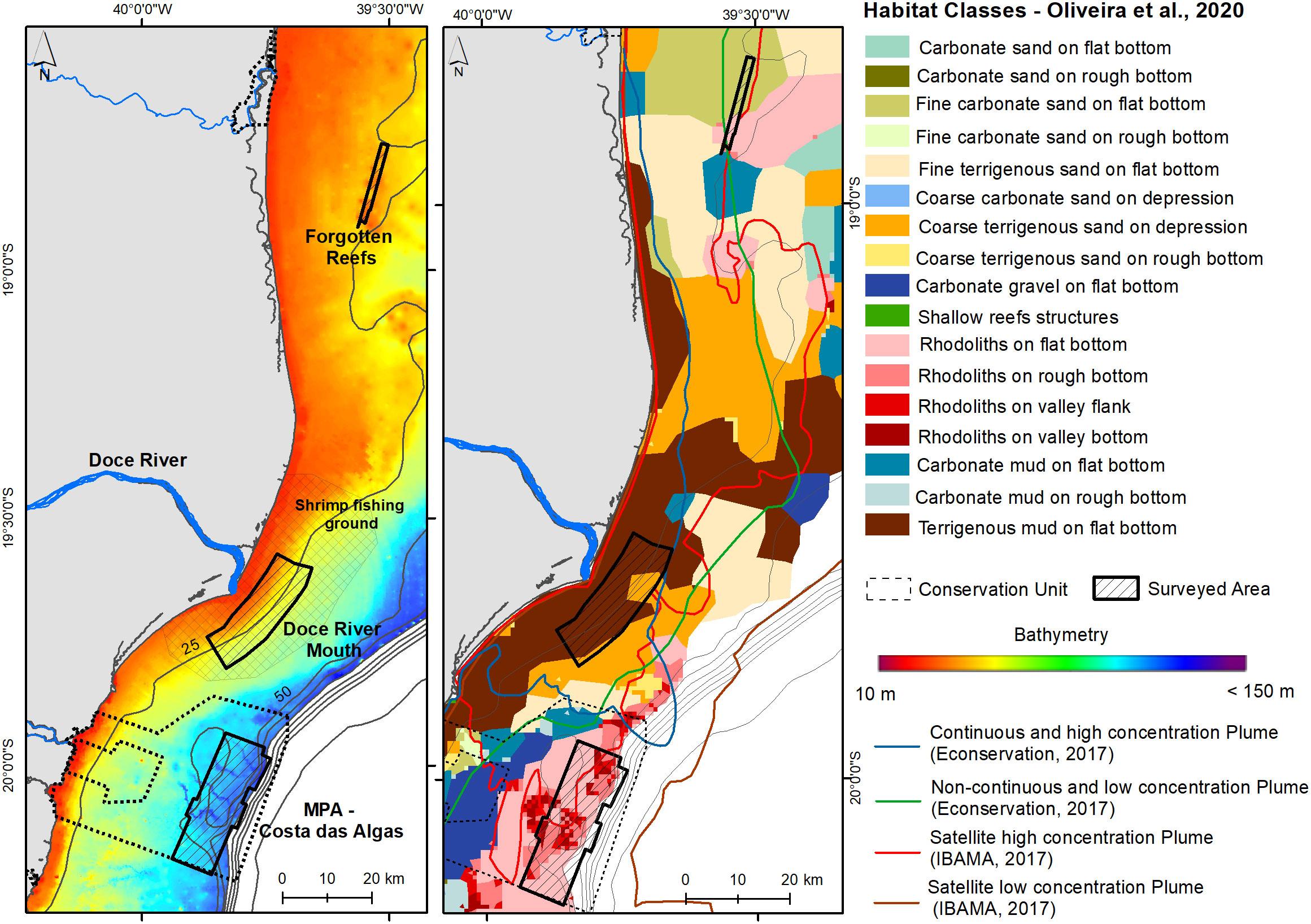
Figure 3 Bathymetric map showing the three selected areas for high-resolution habitat mapping and the habitat map modified from Oliveira et al. (2020) combined with the Doce river plume extension (Econservation, 2017; IBAMA (Instituto Brasileiro do Meio Ambiente e dos Recursos Naturais Renováveis), 2017), Conservation Units, and Fishing Grounds.
The MPA Costa das Algas and Santa Cruz Wildlife Refuge are Marine Protected Areas established in 2010, to protect, conserve and recover the natural environments and biodiversity of this region (Brazil. Decree 2010 July 17th). These areas are located in the central portion of the Espírito Santo Shelf, around 30 km southward from the Doce River Mouth, representing a narrow shelf (50-60km) (Bastos et al., 2015). The region is characterized by low sediment input, irregular seafloor morphology, and paleovalleys (Bastos et al., 2015). This MPA presents a high sensibility (habitat composed of rhodolith beds having a complex morphology), in an area with a low risk of plume influence, but less than 30km from the river mouth.
The Doce River prodelta/depocenter was the main tailing accumulation site. This area is an important shrimp fishing ground, both for artisanal and industrial fisheries (Bourguignon et al., 2018). The Doce River Mouth’s adjacent inner shelf is characterized by a mud/sandy-mud deltaic lobe/prodelta. Sedimentary dispersion patterns are influenced by fluvial and seasonal meteorological conditions (Quaresma et al., 2015).
The Forgotten Reefs are located around 60km northward from the river mouth and are part of the Abrolhos Shelf. The occurrence of these reefs was only known by local fisherman, so there is very little knowledge about this reef area, with a medium to long-term potential tailing influence due to net riverine sediment transport northward. These reefs were first acoustically mapped by Vieira et al. (2019) and very little was known about them when the dam collapse occurred. Moreover, the northern Abrolhos shelf comprises the largest coralline reefs in the South Atlantic, where is located the Abrolhos National Marine Park, a no-take MPA.
2.2.2 High-resolution benthic habitat mapping
Seafloor mapping was carried out using acoustic surveys (multibeam echosounder acquiring bathymetry and backscatter) and ground-truthing with dropcam videos and Van Veen grab sampler. From the dataset - bathymetry, backscatter, and dropcam images, statistical segmentation of the acoustic dataset, and classification techniques (integrating acoustic and ground-truth) were applied to define the habitat distribution in the study area, using a supervised approach. All the steps are summarized in Figure 4.
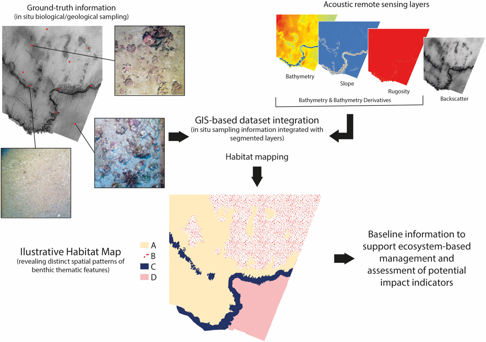
Figure 4 Flowchart indicating the methodological steps for high-resolution potential habitat mapping.
The acoustic surveys were carried out using an R2Sonic 2024 multibeam echosounder (MBES) between January 2019 and March 2020. The MBES system was paired with a POS MV Wave Master Inertial Navigation System (INS), with differential positioning. Before the survey, patch test was carried out to calibrate angular offsets. During the survey, SVP casts were deployed every 3 hours using a Valeport Mini configured to collect sound velocity, salinity, temperature, and pressure. The elevation data for tidal correction were obtained by ADCP moored close to each area. The dataset was assessed during the survey to ensure data quality using the QPS Qimera software suite. Data post-processing was carried out using QPS Qimera and QPS Fledermaus Geocoder Toolbox (FMGT), A 2 m horizontal resolution bathymetric and backscatter surfaces were produced. Ground validation surveys were planned after the basic interpretation of acoustic data to sample all seabed types based on morphology and backscatter strength.
To optimize the time of analysis and allow the repeatability of processes, an automatic supervised technique - RSOBIA (Remotely Sensed Object-Based Image Analysis) - was applied to segment and classify the input data set (bathymetry and backscatter resampled to 20 m due to computational resource limitations). RSOBIA is an ArcGIS licensed extension whose scope of analysis includes a one-band image segmentation and categorization based on three main properties: slope, rugosity, and backscatter (Le Bas, 2016; Innangi et al., 2019).
Seafloor images are among the ground-truthing methods to support seabed classification and are traditionally analyzed by experts, despite the limitations concerning the laborious work and repeatability. The seabed footage was obtained with a dropcam system composed of a metallic pyramidal structure (60 cm x 60 cm base dimensions) coupled with two cameras (GoPro Hero models) and lights. Table 2 presents general information about each dataset collected.
Table 2 Acoustic and ground truth information for the 3 study areas.
Images were used strictly for ground-validation of the segmented classes, and no image classification scheme was applied for the image analysis. Seafloor images were qualitatively described and labeled according to their substrate and geomorphological characteristics, in a similar way as do models such as CATAMI (Althaus et al., 2015) and Coastal and Marine Ecological Classification Standard (FGDC CMECS, 2012) for physical components observed in imagery. The images were superimposed on the RSOBIA segments. Therefore, a subjective interpretation was applied to name the segmented classes based on seabed images, resulting in the final benthic habitat map. Even though, most of the habitat maps take into account other factors such as physical oceanography and biological characterization, in the current work the habitat results are based on geomorphology and substrate type. However, it is important to note that two areas are dominated by carbonate sedimentation, so substrate types are named as their living “biogenic component”, such as Rhodoliths and Reefs.
3 Results
3.1 MPA Costa das Algas
The mapped area presents a complex morphology varying from flat beds to shelf-incised valleys showing a sediment cover of fine sediments, carbonate gravel, rhodoliths and calcareous algae crusts. Water depth varies from 45 to 100 m and backscatter intensity indicates high values in most parts of the area (values between -18 dB and -21 dB) (Figure 5). Incised valleys vary within a depth range from 50 to 90 m. The classification defined 6 distinct potential habitats (see Figures 5, 6). A seabed covered by carbonate gravel with sparse rhodolith dominates the region, followed by rhodoliths and unconsolidated beds - including most of the incised valleys - highlighting the complexity of the region in terms of morphology and the habitat. The higher slope values outline the valley class. One can note that on the northern incised valleys there is a massive presence of rhodoliths beds (class Rhodolith on valley bottom), emphasizing the occurrence of rhodoliths in distinct morphology patterns. Moreover, the lower backscatter values are related to the valleys classified as unconsolidated beds.
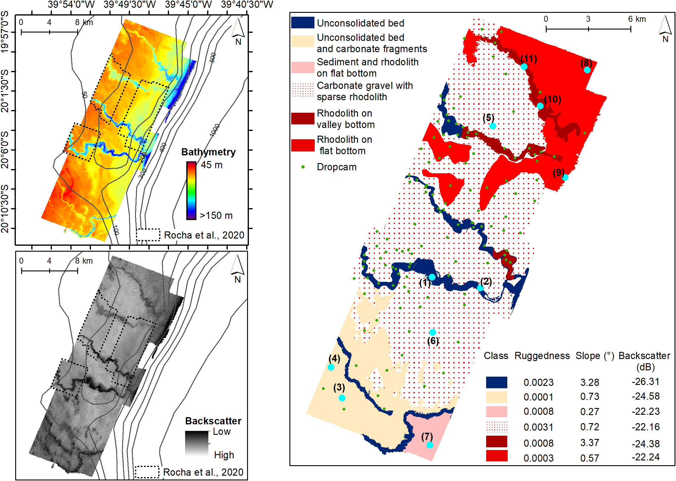
Figure 5 MPA Costa das Algas mapped site - top left bathymetric map (resolution of 2 m), bottom left backscatter intensity map (low intensity darker and high-intensity lighter, with resolution of 2 m), on the right is the potential habitat classification map (resolution of 20 m) with the table originated from each class. The green dots are drop camera stations and light blue dots are drop camera stations with bottom images shown in Figure 6.
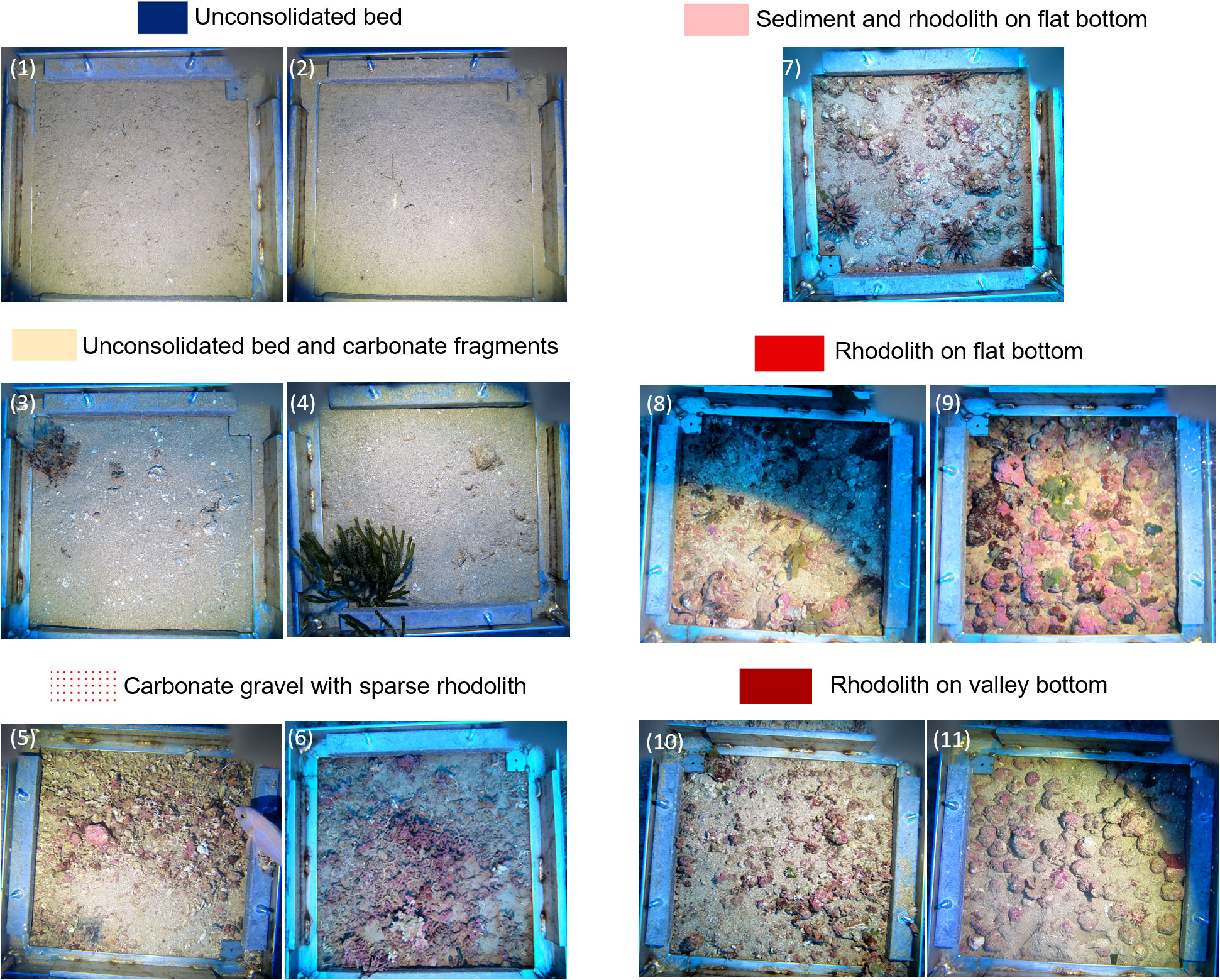
Figure 6 Drop Cameras images from APA Costa das Algas site, numbering according to the light blue dots on the previous figure.
All classes were sampled, and Figure 6 presents 11 bottom frames illustrating the seabed for the 6 classes.
3.2 Doce River mouth
The inner shelf adjacent to the Doce river mouth presents a regular and flat morphology down to a water depth of around 25 m, where coastal-oblique linear ridges occur, reaching 34 m deep (Figure 7). Seabed sediments consist mainly of mud to sandy mud, with an increase in sand content offshore. Steep features/scarps and erosive features were observed in shallower depths. It was noticed that the muddy classes reach deeper depths in the southwest part of the area in comparison with the sandy dominance in the northeast. Backscatter intensity values were predominantly low (around -26 dB considering the values from the mosaic, not based on angular response) in the shallow regions and higher intensities are found associated with the elongated ridges (around -19 dB considering the mosaic values). The potential habitat map shows a total of 5 classes (Figure 7), with a muddy class, mostly flat, gently dipping seaward. The sandy bottom flat or with ridges defines the others classes in this area, distinguished by the presence of these geomorphic features.
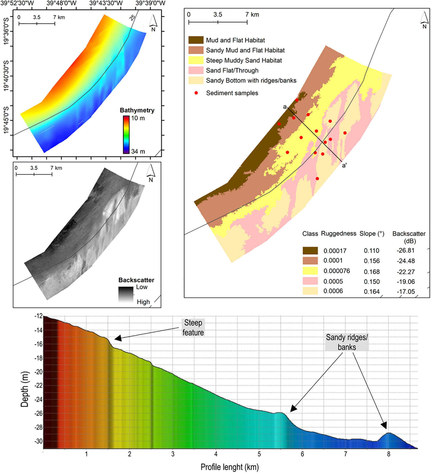
Figure 7 Doce river mouth site - top left bathymetric map (resolution of 2 m), bottom left backscatter intensity map (resolution of 2 m), on the right is the potential habitat classification map (resolution of 20 m) with the table originated from each class, and below the bathymetric profile indicating features.
The drop camera’s image survey attempt was not satisfactory due to very poor visibility in the high turbidity water column. Therefore, the ground-truthing for seafloor classification in this region was based on only 14 sediment samples (Figure 8).
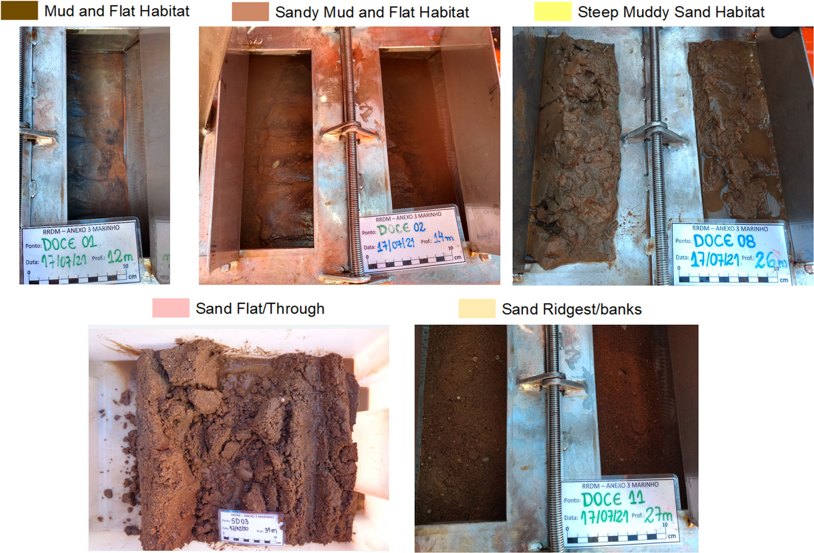
Figure 8 Sediment samples images from the Doce River Mouth site.
3.3 Forgotten Reefs (Recifes Esquecidos)
The northernmost selected area is characterized by reef and inter-reef habitats. In the mapped area, 900 reef structures were identified together with distinct inter-reef areas and bedforms, comprising 4 classes (Figure 9). The spatial distribution of those reef structures comprises three main reef patches, showing a NE/SW alignment. Reef heights can reach up to 12 m, with their tops occurring between 13 and 20 m deep. In between the reefs, flat inter-reef areas were defined and the presence of longitudinal bedforms, interpreted as furrows, were observed. Uncalibrated backscatter intensity values vary from -14 dB to -29 dB.
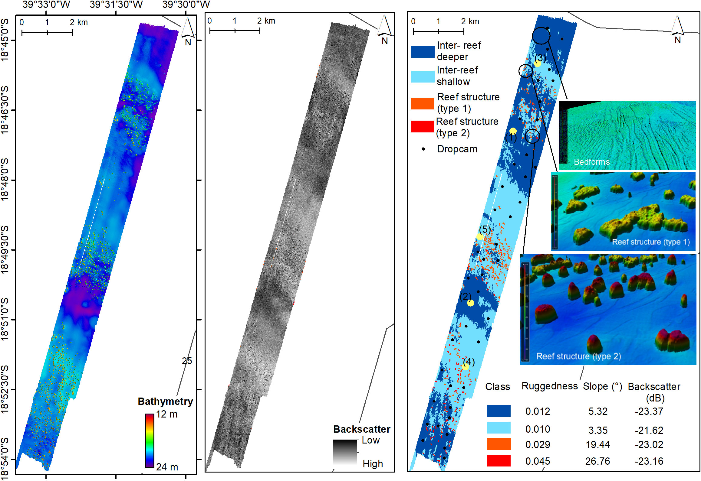
Figure 9 Forgotten Reefs site - from left to right bathymetric map (resolution of 2 m), backscatter intensity map (low intensity darker and high-intensity lighter, with resolution of 2 m), potential habitat classification map (resolution of 20 m) with the table originated from each class. In green are all drop camera sites. Light yellow dots mark the location of the images shown in Figure 10.
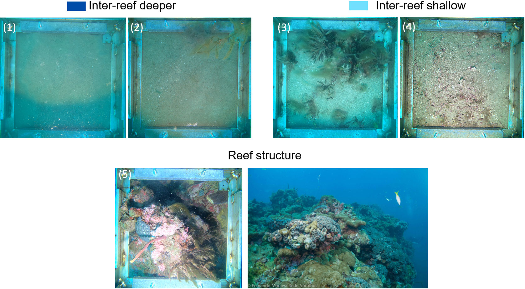
Figure 10 Drop Cameras images from the Forgotten Reefs site, numbering according to the light blue dots in Figure 9. Panoramic view image courtesy of Rede Abrolhos.
The classification tool defined two types of reef seascapes based on the rugosity and reef top depth. The southern reefs range from 13 to 15 m depth and the northern ones from 18 to 20 m depth. Two inter-reef classes were defined and are marked by a gravel-sand class, and were differentiated mostly according to depth range and backscatter intensity (coherent with what was seen in the drop images 3 and 4 located in regions shallower than and 1 and 2 - depicting a seabed with coarse sediment and carbonate fragments).
4 Discussion
4.1 Benthic habitat mapping guidance for marine management and conservation
Marine environments are frequently evaluated according to some criteria such as the biodiversity they support, the ecosystem services they provide (Woodhead et al., 2019), and the related habitat sensitivity. Nelson and Burnside (2019) obtained important results from one methodological framework in which habitat classification exerts a fundamental role to categorize priority areas for marine management. Willaert et al. (2019) presented an ecosystem vulnerability index in which habitat mapping is one of the pillars that support the model of risk assessment under different prospective scenarios. Therefore, benthic habitat maps can be used as an integrity indicator of the benthic habitat extension and as a base for a potential ecosystem vulnerability assessment. Habitat integrity and connectivity is largely used as an indicator in environmental impact studies in terrestrial environments (Ayram et al., 2015), but there are still no extensive habitat mapping studies that cover satisfactorily many marine areas compared to the terrestrial ones.
The seabed mapping results detailed the marine geodiversity throughout the three areas, providing, at this resolution, primary information for the study of potential benthic habitats and their distribution. One of the main issues of the ABMP was the lack of knowledge about the seabed at a suitable temporal and spatial scale for planning the distribution of sampling stations and areas to be mapped. Initially, regional maps were used to evaluate the seascape of the AESCS (see further discussion in section 4.2) in order to define a sampling design. The first preliminary results achieved from the detailed seabed mapping led to adjustments on the position and distribution of sampling stations. Also, it supported a better interpretation of acting tailing dispersion processes and the context of the environmental impact on sediment quality and on the benthic community.
Structurally complex habitats can be directly related to high biodiversity (Ross and Quattrini, 2007; Buhl-Mortensen et al., 2010), and seafloor complexity is being used as a proxy for environmental sensitivity, representing a suitable indicator to guide habitat conservation (Alsterberg et al., 2017). Environmental heterogeneity is known as a universal driver of species richness since it increases availability in space-providing refuge areas (Stein et al., 2014). In this paper, it was found that, for the researched areas, some potential habitats deserve more attention: the incised-valleys/shelf-valleys, rhodoliths bed, and submerged reefs.
More than 60% of the potential benthic habitats found for the MPA Costa das Algas had rhodoliths on a wide range of seafloor morphologies, from the bottom of valleys and flat homogeneous beds to a sparser configuration. These rhodolith habitats are highly relevant and widespread along the Brazilian margin. Combining the Abrolhos and Espírito Santo shelf, the extension of rhodolith beds reaches around 28,000 km2 (Amado-Filho et al., 2012; Vieira et al., 2019). They form an immense carbonate realm, topographically less complex than coral reefs but well-known as ecosystem engineers that provide microhabitat complexity for invertebrates and algae (Foster, 2001). Moura et al. (2021) showed that rhodolith beds can be as attractive as reefs in terms of fish biomass and species richness. Moreover, rhodolith beds support a variety of organisms, including invertebrates that inhabit the surface and interior of the carbonate nodules (Hall-Spencer, 1998; Peña and Bárbara, 2008; Nelson, 2009; Steller and Cáceres-Martínez, 2009; Ávila and Riosmena-Rodriguez, 2010; Riosmena-Rodriguez et al., 2010). Rhodoliths might be affected by any changes in sedimentation patterns, i.e., if there is an increase in sediment input or resuspension that decreases solar irradiation (Wilson et al., 2004; Riul et al., 2008), the nutrients that maintain the living algae could diminish or have deleterious effects due to physical and chemical effects, affecting their survivorship and recruitment, and potentially inducing stress responses (Harrington et al., 2005). On top of that, Amado-Filho et al. (2012) have shown that extensive rhodolith beds are an important calcium carbonate reservoir, comparable to the main tropical coral reef areas around the globe, drawing attention to issues such as blue carbon and climate changes. In this case study, at to this point, no main impact was observed or recorded on rhodolith habitats. Results from the ABMP showed no evidences of tailings reaching or impacting the rhodoliths on the offshore area (deeper > 40m) of the MPA Costa das Algas.
Shelf valleys provide great ecological complexity to the MPA Costa das Algas site. The mud-dominated shelf-incised valley is as deep as the shelf break and could act as conduit for the transport of fine sediments to the deep-sea (Törnqvist et al., 2006). Valleys function as depocenters which can lead to the accumulation of not only sediments but also contaminants bypassing them through the slope to continental rise (Liu et al., 2001). Shelf-incised valleys also host a variety of ichthyofauna and are well known by the artisanal fleet as fishing grounds. It was suggested by Oliveira et al. (2020) that preserving those “negative relief” features (deeper than the surrounding region) would enhance the diversity of the benthic community bringing greater biodiversity to the site since they locally increase depth gradient and roughness to the shelf seabed. Moreover, the valley margins reach up to 75-80 m deep forming a slope with the same water depth of the local shelf break, forming a slope-like mesophotic system in the continental shelf. The habitat mapping results suggested that the valley were under sampled within the ABMP. Only one sampling station is located in a valley bottom. Up to this point, no more stations were added to the valleys, but an effort is being planned to increase the number of samples in the near future.
Coral reefs are among the most vulnerable ecosystems in the marine systems (Camoin and Webster, 2015). They sustain marine life at all food web levels enhancing complexity, biodiversity, and productivity (Moberg and Folke, 1999; Hedley et al., 2017). The northern surveyed area showed, in detail, an extensive presence of unmapped and understudied submerged reefs. Currently, this reef habitat represents the only inner shelf reef evidence southward from the most important coralline complex in the South Atlantic, the Abrolhos National Marine Park, and the MPA Ponta da Baleia (Moura et al., 2013; Ferreira et al., 2020). This finding has a significant great appeal since coral reefs are well-known by the public and a target for conservation (Harris and Baker, 2020). Similar to the rhodoliths-related benthic habitat, high input of sediments/turbidity could cause the burial of the photosynthetic organisms and benthic communities posing a threat to those highly sensitive habitats causing deleterious effects on the ecosystem that would need a long time to recover (Wilson et al., 2004). On top of that, the potential input of tailings could influence benthic organisms’ growth and even become incorporated into coral skeletons (Cardoso et al., 2022). Francini-Filho et al. (2019) showed no evidence of tailings impact in the Forgotten Reef area during the first year after the disaster. Environmental impact and monitoring studies conducted along the AESCS indicate a medium-term tailing dispersion northward, along the coast (Quaresma et al., 2021; Nascimento et al., 2022). It seems that even if the Doce River plume may reach the Forgotten Reef area, so far no clear evidence of tailings impact on the coral reefs were observed.
By far, the Doce River mouth was the region most directly affected by iron ore tailings input. Although the regional and high-resolution mapping produced does not have enough resolution (neither spatial nor temporal) to capture the presence of tailings, important contributions were provided that can be integrated with others proxies more appropriate for such purpose. A suspension mud with high sediment concentration was observed in the area during the first week of tailings arrival (Quaresma et al., 2020). The presence of a muddy depocenter, located southward from the river mouth, is observed in the seabed mapping and agrees with previous publication (Quaresma et al., 2015). The detailed seafloor mapping revealed the presence of linear sand ridges offshore from the muddy bed and the occurrence of erosive features (scars). The sandy ridges and scarp features reinforce a transitional mud to sand sedimentary dynamic towards offshore indicated by Quaresma et al. (2015) and Vieira et al. (2019), allowing us to infer an active erosion process and sediment resuspension that potentially could bypass sediments into the outer shelf. Once deposited, the presence of this sediment can represent an indicator of potential impact. Since it is a highly dynamic sedimentary region, a temporal representation of the habitats, as considered in Anderson et al. (2008) and Pittman et al. (2021), might be taken into account for a medium/long-term impact analysis. The less complex habitat and the absence of carbonate structures could represent a lower-sensitivity ecosystem, but this can only be confirmed with further analysis. In addition, the presence of bedforms and erosive features could be considered indicators of a highly dynamic environment that could indicate a shorter recovery time to disturbance when compared to the hardground environment (Harris, 2014). However, in this case, the potential low complexity of the seabed and the absence of carbonate structures does not make the Doce River mouth a less sensitive ecosystem in a vulnerability assessment context. The economic and social impacts must be taken into account (Janssen et al., 2006). The mud and sandy mud flat classes adjacent to the Doce River mouth area are an important shrimp fishing ground, both for local artisanal and industrial fishing. Due to the toxicity of the tailings, fishing activities were officially suspended and prohibited since the first months after the dam failure. Moreover, the beaches along the Doce river coastal plain encompass a Biological Reserve with an important sea turtle nursing ground, and the Doce River mouth is a main habitat for a population of cetaceans. Because of the ecological importance of this region, there is an initiative to create the Doce River mouth MPA.
In terms of tailings impact along the Doce River mouth adjacent inner shelf, several studies indicate that the base of the trophic chain were severely impacted and has not recovered so far. Plankton and benthic communities were altered due to dissolved and particulate iron ore tailings input (Bonecker et al., 2022; Nascimento et al., 2022; Rocha et al., 2022), levels of toxicity in fish were high during the first years until a better condition was reached (Bevitório et al., 2022), and water and sediment quality were found to be as highly contaminated during the first 3 to 4 years and after that (Orlando et al., 2020; Quaresma et al., 2021), a variation on the environmental quality status is influenced by prevailing seasonal hydrological and meteo-oceanographic conditions (Longhini et al., 2022).
4.2 Multi-design approach: from broad to finer details
Whilst maps are used as an important tool to spatially represent marine habitat information to easily communicate with non-experts, they also produce outputs that will depend on the methodological approach, data quality and scale (Lecours, 2017). Spatial scale and resolution are important concepts in seabed mapping, and more attention has been focused on them in the past decades (Apostolopoulou and Paloniemi, 2012; Lecours et al., 2015; Lecours, 2017; Misiuk et al., 2019; Menandro and Bastos, 2020).
Global and regional ocean floor terrain models have undoubted importance for various purposes associated with MSP, but they may not be adequate for other purposes that require a greater level of detail, such as conservation actions and other components that involve the input of multiple data sources (Lyons et al., 2020; Schill et al., 2021). In this context, hierarchical classification models seem to be an interesting path to integrating multi-scale datasets adapting them to the user’s needs (Guarinello et al., 2010; Porskamp et al., 2018).
The multi-design approach used in this case study revealed that in consonance with what was observed by Bastos et al. (2015) and Vieira et al. (2019), the potential habitats for each region point to morpho-sedimentary sectors along the shelf as, for example, the muddy-flat habitat in the Doce River Mouth, and the carbonate-irregular and rugged seabed marked by incised valleys in the MPA Costa das Algas. However, some specific seabed morphological features were poorly captured by the regional scale results (Vieira et al., 2019; Oliveira et al., 2020). In MPA Costa das Algas, the regional habitat map showed rhodolith classes covering 100% of the area. A higher resolution approach allowed to achieve a higher level of detail in the incised valleys, as well as to acknowledge regions with different rhodolith coverage (as proposed by Rocha et al., 2020). The Forgotten Reefs area is not shown in the regional bathymetric map (1:50000 scale). We were able to map and identify isolated reef pinnacles based on a high-resolution bathymetric dataset, launching a new challenge regarding its regional-scale representation. Although the differences between the regional and high-resolution habitat mapping on the Doce River Mouth area are less marked in terms of sediment coverage, the high-resolution mapping could detect sand ridges and erosive features. In addition, the detail achieved by the segmentation applied based on high-resolution data contributed to detecting the distribution of muddy sediments and an inner shelf depocenter more accurately, and could be even more detailed if it involved a multifrequency methodology in terms of seafloor distinguishment (see Menandro et al., 2022). The high-resolution seabed mapping in the inner shelf adjacent to the Doce River Mouth revealed a potential sediment cross shore process, which can help interpret tailings dispersion. Although a multi-scale analysis testing different resampling resolution is out of the scope of this work, the visual comparison analysis in this area suggests that in low morphological complexity areas (mostly flat, for example) habitat classifications in different scales may have a better match.
Despite the little guidance on the appropriateness of multi-scale approaches for specific benthic habitat mapping applications, we can evaluate gaps in knowledge and lack of certainty in the interpretation of the habitats. A simple confidence assessment can be applied, so that users and decision-makers could use the spatial data more adequately. Kaskela et al. (2019) used a 3-step-method (coverage area, classes have boundaries, every class sampled) developed by the UK Joint Nature Conservation Council to assign a confidence score to any area. The maximum score (4 stars) is achieved if the seabed data coverage is good, the classes have distinct limits, and all of them were sampled; while the minimum score results represent the absence of remote sensing methods and direct samples. Considering a scenario in which the Espírito Santo continental shelf was not studied (0 star), the monitoring program planning would be compromised without any previous knowledge of the seabed. On the other hand, when the scenario is based on the scientific literature (Bastos et al., 2015; Quaresma et al., 2015; Bourguignon et al., 2018; Vieira et al., 2019; Oliveira et al., 2020), the score might be 2 or 3 stars. Therefore, increasing the detail of data in the AESCS as it was achieved through a multibeam survey and assuming that all different classes presented in that area were represented in the new dataset, a maximum 4-star score could be the new confidence index for the mapped areas. The multi-design approach also indicated that a regional analysis can indicate potential vulnerability as a first assessment approach, provide essential information for planning a monitoring program, and can contribute to the design of a MSP. However, the high-resolution habitat mapping is needed to evaluate and produce a higher-confidence level, especially more if it involves questions related to conservation, such as the presence of reef and rhodolith habitats.
4.3 Changing a Brazilian paradigm: applying the habitat mapping concept
It is important to point out the relevance of this study to Brazilian MSP as a decision-making path to underpin ecosystem-based management across the distinct marine activities. Considering principles such as adequate spatial scale, the connection between ecosystems, and interdisciplinarity, frequently cited in the literature (Long et al., 2015), habitat mapping fundamental to the scientific development and support for MSP.
Our results support the delineation of priority areas aiming for protection and guiding for other studies, as well as shed light on the importance of habitat mapping through a multi-design classification. The higher resolution reached in this habitat mapping study provided a significant improvement in the level of knowledge of the Espírito Santo continental shelf seabed, and also an important basis for a reliable decision-making process. The Abrolhos Shelf is another outstanding Brazilian example where habitat mapping completely changed the level of knowledge, once 8844 km² of its reefs were mapped (Moura et al., 2013) against a previously known estimation of only 500 km². In turn, the Amazon continental shelf, which requires a great number of research since the 1980s and oil and gas operation, has been recently mapped with MBES revealing an extension of mesophotic reefs and rhodolith beds (Moura et al., 2016; Lavagnino et al., 2020; Vale et al., 2022).
Worldwide, there are several national mapping programs, including projects on a global scale. Nevertheless, Brazilian authorities have not focused on a national program on habitat mapping in the past decades. There have been several initiatives from the Brazilian Navy in partnership with the Brazilian Geological Survey (CPRM), Ministry of Science and Technology, and Ministry of the Environment, among others, for example, the Brazilian Continental Margin Global Reconnaissance - REMAC (between 1974 and 1977), the Brazilian Margin Limits Studies - LEPLAC (between 1987 and 2019) for meeting the UNCLOS (United Nations Convention on the Law of the Sea) criteria for defining the different limits concerning Brazilian sovereignty in seabed exploitation, the Living Resources of the EEZ (REVIZEE – Marine Resources of the Economic Exclusive Zone, Ferreira, 2005), the Continental Shelf Mineral Resources Study (REMPLAC), the Brazilian Oceanic and Coastal Zones Geographic Atlas (IBGE, 2011), the products from the REVIZEE (Marine relief maps from the southeast, south, and central regions, 2005), etc. Alberoni et al. (2019) managed to build a digital terrain model compiling REMAC and LEPLAC datasets (among others) resulting in a national grid that is now easily available for download. Besides the regions already mentioned, such as the Espírito Santo Continental Shelf (Bastos et al., 2015; Vieira et al., 2019; Oliveira et al., 2020), the Abrolhos Shelf (Moura et al., 2013; Menandro et al., 2020) and the Amazon Shelf (Nittrouer et al., 1991; Moura et al., 2016; Lavagnino et al., 2020), from the scientific point of view, studies conducted in the Pernambuco Continental Shelf have also made an important contribution to regional seabed habitat mapping in Brazil (Goes et al., 2019; Lucatelli et al., 2019). It is noteworthy that seabed habitat mapping works carried out in Brazil apply different approaches and methods, and have been made up of local and isolated efforts, sometimes at a state level, but mainly carried out by Universities’ research groups (Avena et al., 2020; Ferreira et al., 2020; Fontes et al., 2020; Gandra et al., 2020; Gomes et al., 2020; Oliveira et al., 2020; Rebouças et al., 2020; Vital et al., 2020) and scientific networks as the Abrolhos Network (PELD), the AmbTropic INCT, and the Rede Rio Doce Mar (presented here).
But why does habitat mapping matter for Brazilian Science and Managers? From the discussed results up to here, some issues prove to be important to understanding the Brazilian scenario regarding habitat mapping, such as data availability and spatial scale. Most of the reasons for not having a national habitat map are due to i) gap in understanding about the importance and benefits of seabed habitat mapping; ii) the lack of a single ocean database, with an “easy to get data” platform, that concentrates the geological, chemical and biological information available on the seabed, preferentially, in the same database with all oceanographic data about the water column properties and ocean circulation; and iii) a lack in defining seabed habitat maps as a national priority, including not only sediment distribution and morphology, but also biological and chemical properties. Brazil already has the conditions to plan, execute and maintain a habitat mapping program, partnering with Universities, Government Institutions (e.g, the Brazilian Navy), and the private sector. However, it is urgent to plan and implement a national database capable of supporting a habitat classification effort on a broader national scale (Gandra et al., 2018).
The national scenario started to change when Brazil committed to the Sustainable Development Goals (SDG) of the United Nations and considering SDG 14 (Life in the Water), Brazil has also engaged in the goals of the UN Decade of the Ocean Science for Sustainable Development. Among a series of actions that are in the course, the new Marine Resources Sectoral Plan (Plano Setorial para os Recursos do Mar), coordinated by the Marine Resources Interministerial Committee (CIRM) defined Marine Spatial Planning as National Program that should be concluded by 2030. The basis for developing the Brazilian MSP is to use a single database platform that receives data from different sources and produces a Continental Shelf habitat map and all the relevant and necessary information (economic activities, social uses, etc) to yield a MSP. The strategy for the Brazilian MSP is to divide the Brazilin margin in four regions (south, southeast, northeast and north), staring the desktop studies and data compilation from the south region and move towards the north region. There is still a long way to go, parameters to be defined, and plans to lay down for discussion, but at least, it seems that Brazil is moving towards a consolidated national habitat map and an MSP.
Brazilian authorities should be aware that a Brazilian habitat classification scheme needs to be discussed following the main objectives of a national map, in a way that can be flexible or adaptable in multiscale approaches. The selection of environmental parameters and how they will be modelled to produce a habitat map need to be considered for the entire Brazilian Shelf/Margin and be replicable. This goal is not an easy or straight forward task, as habitat maps are scale-dependent and contents may vary depending on stakeholders. However, all the data used need to be made available for future scientific use, allowing other approaches to be tested.
A final point that we need to raise is that high-resolution maps are still crucial for local and specific environmental assessments, as shown in the case study presented herein, and can be hierarchically integrated into the classification scheme. Therefore, a national-scale habitat map or even a seascape or benthoscape map (following Brown et al., 2011) to support national-scale MSP should cover local and regional assessments. Hence, although the strategy to fulfil the commitment of having a Brazilian MSP by the end of 2030 is underway, there need to be further commitments and efforts to select specific areas of interest, based on different criteria to be discussed, for a high-resolution mapping. These criteria could include, for example, a vulnerability and a user-conflict indexes. The utmost condition is that Brazilian authorities and scientists should not let this opportunity pass by in order to produce a fundamental knowledge of the Brazilian Seabed, nationally described as the Blue Amazon.
5 Conclusion
The results showed the potential that high-resolution mapping to inform physical habitat classification and potential ecosystem vulnerability to Aquatic Biodiversity Monitoring Program (ABMP). Some features previously unnoticed in a larger scale mapping, such as the erosive features in Doce river Shelf, detailed morphology of paleovalleys and rhodolith beds, and a huge amount of reef structures, draw attention to potential impacts due to tailings.
Regional habitat maps are of immense importance, as they serve as a tool to ensure spatial planning initiatives, being used as a database to model priority areas for conservation or areas that can be made available for exploration bids. They can also be used to define specific areas that need to be mapped at a higher resolution, because they are of interest for better management, or they can be used as a base for risk analysis and threats, predicting the most vulnerable habitats in face of distinct threats, anthropogenic or natural, such as climate changes and ocean acidification.
Detailing the seabed mapping proved essential for a more careful assessment of ecosystem vulnerability (recognition of reef structures and rhodolith coverage for example), and the segmentation tool RSOBIA was successfully applied. As future technologies unveil, our ability to quantify and qualify the seafloor will evolve in a constant journey to understand patterns and changes in the environment. In the meantime, datasets similar to this will serve as good way to communicate and coordinate protection and management in the habitats across the ESACS. Therefore, hierarchical classification models capable of compiling multiple designs and scales emerge as an interesting way to integrate data at more than one scale to suit the user needs.
Although Brazil has never produced a regional or national habitat map for the entire continental margin, there are already conditions to plan, execute and maintain a habitat mapping program, partnering with Universities, Government Institutions (e.g., the Brazilian Navy), and the private sector. In the context of the UN Decade of Ocean Science for Sustainable Development targets, it is urgent to plan and implement a national database capable of supporting a habitat classification effort on a broader national scale, with the flexibility to support a multi-design or a multi-scale approach. There is still a long way to go, and it seems that Brazil is moving towards a consolidated national habitat map, but we must assure that science-based solutions are a priority for Brazilian decision makers.
Data availability statement
The original contributions presented in the study are included in the article/supplementary material. Further inquiries can be directed to the corresponding author.
Author contributions
PM: Field work, conceptualization, formal analysis, investigation, writing – Original Draft; AL: Field work, conceptualization, formal analysis, writing; FV: formal analysis, investigation, visualization; GB: field work, formal analysis, visualization; TF: formal analysis, investigation, visualization; AB: conceptualization, Review and Editing, Supervision. All authors contributed to the article and approved the submitted version.
Funding
This work is part of the Environmental Monitoring Program (PMBA) – Fundação Renova-Fest-RRDM. FAPES - Fundação de Amparo a Pesquisa do ES, Edital Recuperação Bacia do Rio Doce. Open Access fees funded by FAPES.
Acknowledgments
We are grateful to Dra Kyssyanne Oliveira for the time taken to process and provide us the tide data needed in bathymetric processing. ACB is a Research Fellow of CNPq (PQ 1C). This article is a contribution by Rede Abrolhos, INCT-AmbTropic and Rede Rio Doce Mar - PMBA.
Conflict of interest
The authors declare that the research was conducted in the absence of any commercial or financial relationships that could be construed as a potential conflict of interest.
Publisher’s note
All claims expressed in this article are solely those of the authors and do not necessarily represent those of their affiliated organizations, or those of the publisher, the editors and the reviewers. Any product that may be evaluated in this article, or claim that may be made by its manufacturer, is not guaranteed or endorsed by the publisher.
References
Alsterberg C., Roger F., Sundbäck K., Juhanson J., Hulth S., Hallin S., et al. (2017). Habitat diversity and ecosystem multifunctionality–the importance of direct and indirect effects. Sci. Adv. 3 (2), e1601475. doi: 10.1126/sciadv.1601475
Althaus F., Hill N., Ferrari R., Edwards L., Przeslawski R., Schönberg C. H. L., et al. (2015). A standardised vocabulary for identifying benthic biota and substrata from underwater imagery: The CATAMI classification scheme. PloS One 10 (10), e0141039. doi: 10.1371/journal.pone.0141039
Alberoni A. A.L., Jeck I.K., Silva C.G., Torres L.C. (2019). The New Digital Terrain Model (DTM) of the Brazilian Continental Margin: Detailed Morphology and Revised Undersea Feature Names. Geo-Marine Letters 40 (6), 949–64. doi: 10.1007/s00367-019-00606-x.
Amado-Filho G. M., Moura R. L., Bastos A. C., Salgado L. T., Sumida P. Y., Guth A. Z., et al. (2012). Rhodolith beds are major CaCO3 bio-factories in the tropical south West Atlantic. PloS One 7 (4), e35171. doi: 10.1371/journal.pone.0035171
Anderson J. T., Van Holliday D., Kloser R., Reid D. G., Simard Y. (2008). Acoustic seabed classification: Current practice and future directions. ICES J. Mar. Sci. 65 (6), 1004–1011. doi: 10.1093/icesjms/fsn061
Apostolopoulou E., Paloniemi R. (2012). Frames of scale challenges in Finnish and Greek biodiversity conservation. Ecol. Soc. 17 (4), art9. doi: 10.5751/ES-05181-170409
Avena P. P., Dominguez J. M. L., Lemos I. C. (2020). “Benthic habitat mapping in a shallow tropical bay: The itaparica channel–eastern Brazil,” in Seafloor geomorphology as benthic habitat (Elsevier), 175–186. doi: 10.1016/B978-0-12-814960-7.00008-7
Ávila E., Riosmena-Rodriguez R. (2011). A preliminary evaluation of shallow-water rhodolith beds in bahia Magdalena, Mexico Brazilian Journal of Oceanography 59, 365–375. doi: 10.1590/S1679-87592011000400007
Ayram C. A., Mendoza M. E., Etter A., Salicrup D. R. P. (2016). Habitat connectivity in biodiversity conservation: A review of recent studies and applications. Prog. Phys. Geography: Earth Environ. 40 (1), 7–37. doi: 10.1177/0309133315598713
Bastos A. C., Quaresma V. S., Marangoni M. B., D’Agostini D. P., Bourguignon S. N., Cetto P. H., et al. (2015). Shelf morphology as an indicator of sedimentary regimes: A synthesis from a mixed siliciclastic–carbonate shelf on the eastern Brazilian margin. J. South Am. Earth Sci. 63, 125–136. doi: 10.1016/j.jsames.2015.07.003
Bernardino A. F., Pais F. S., Oliveira L. S., Gabriel F. A., Ferreira T. O., Queiroz H. M., et al. (2019). Chronic trace metals effects of mine tailings on estuarine assemblages revealed by environmental DNA. PeerJ 7, e8042. doi: 10.7717/peerj.8042
Bevitório L. Z., Silva N. G., Pirovani J. C. M., Marques J. A., Vieira C. E. D., Zebral Y. D., et al. (2022). Impacts of tailings of fundão dam (Brazil) rupture on marine fish: Metals bioaccumulation and physiological responses. Mar. pollut. Bull. 177, 113511. doi: 10.1016/j.marpolbul.2022.113511
Bonecker A.C.T, Castro M.S., Dias C.O., Sá Mill F. G.N., Ghisolfi R.D., Bonecker S.L.C. (2022). Monitoring of ichthyoplanktonic community at the Doce River mouth and adjacent marine region in Southeast Brazil after Fundão dam collapse. Journal of Sea Research, 189, 102284. doi: 10.1016/j.seares.2022.102284
Bourguignon S., Bastos A., Quaresma V., Vieira F., Pinheiro H., Amado-Filho G., et al. (2018). Seabed morphology and sedimentary regimes defining fishing grounds along the Eastern Brazilian shelf. Geosciences 8 (3), 91. doi: 10.3390/geosciences8030091
Brown C. J., Sameoto J. A., Smith S. J. (2012). Multiple methods, maps, and management applications: Purpose made seafloor maps in support of ocean management. J. Sea Res. 72, 1–13. doi: 10.1016/j.seares.2012.04.009
Brown C. J., Smith S. J., Lawton P., Anderson J. T. (2011). Benthic habitat mapping: A review of progress towards improved understanding of the spatial ecology of the seafloor using acoustic techniques. Estuarine Coast. Shelf Sci. 92 (3), 502–520. doi: 10.1016/j.ecss.2011.02.007
Buhl-Mortensen P., Buhl-Mortensen L. (2018). Impacts of bottom trawling and litter on the seabed in Norwegian waters. Front. Mar. Sci. 5. doi: 10.3389/fmars.2018.00042
Buhl-Mortensen P., Dolan M. F. J., Ross R. E., Gonzalez-Mirelis G., Buhl-Mortensen L., Bjarnadóttir L. R., et al. (2020). Classification and mapping of benthic biotopes in Arctic and Sub-Arctic Norwegian waters. Front. Mar. Sci. 7. doi: 10.3389/fmars.2020.00271
Buhl-Mortensen L., Vanreusel A., Gooday A. J., Levin L. A., Priede I. G., Buhl-Mortensen P., et al. (2010). Biological structures as a source of habitat heterogeneity and biodiversity on the deep ocean margins: Biological structures and biodiversity. Mar. Ecol. 31 (1), 21–50. doi: 10.1111/j.1439-0485.2010.00359.x
Camoin G. F., Webster J. M. (2015). Coral reef response to quaternary sea-level and environmental changes: State of the science. Sedimentology 62, 2. doi: 10.1111/sed.12184
Cardoso G. O., Falsarella L. N., Chiroque-Solano P. M., Porcher C. C., Leitzke F. P., Wegner A. C., et al. (2022). Coral growth bands recorded trace elements associated with the fundão dam collapse. Sci. Total Environ. 807, 150880. doi: 10.1016/j.scitotenv.2021.150880
Cook R., Fariñas-Franco J. M., Gell F. R., Holt R. H. F., Holt T., Lindenbaum C., et al. (2013). The substantial first impact of bottom fishing on rare biodiversity hotspots: A dilemma for evidence-based conservation. PloS One 8 (8), e69904. doi: 10.1371/journal.pone.0069904
Diesing M., Mitchell P. J., O’Keeffe E., Gavazzi G. O. A. M., Bas T. L. (2020). Limitations of predicting substrate classes on a sedimentary complex but morphologically simple seabed. Remote Sens. 12 (20), 3398. doi: 10.3390/rs12203398
Dominguez J. M. L. (2004). “The coastal zone of Brazil: An overview,” in Proceedings of the 8th International Coastal Symposium, Journal of Coastal Research Vol. 39. 16–20.
Econservation (2017). Análise integrada dos contornos do deslocamento das plumas de turbidez no meio marinho (Espírito Santo, Brasil: Relatório Técnico RT ECV 138/17), 146.
Fernandes G. W., Goulart F. F., Ranieri B. D., Coelho M. S., Dales K., Boesche N., et al. (2016). Deep into the mud: Ecological and socio-economic impacts of the dam breach in Mariana, Brazil. Natureza Conservação 14 (2), 35–45. doi: 10.1016/j.ncon.2016.10.003
Fernandes L. F. L., Paiva T. R. M., Longhini C. M., Pereira J. B., Ghisolfi R. D., Lázaro G. C. S., et al. (2020). Marine zooplankton dynamics after a major mining dam rupture in the doce river, southeastern Brazil: Rapid response to a changing environment. Sci. Total Environ. 736, 139621. doi: 10.1016/j.scitotenv.2020.139621
Ferreira C. S. (2005). Mapas do relevo marinho das regiões sudeste, sul e central do brasil: acústica e altimetria por satélite (São Paulo: Instituto Oceanográfico-USP, Universidade de São Paulo, Brasil).
Ferreira L. C., Bastos A. C., Amado Filho G. M., Leite M. D. A., C. Boni G., C. Moraes F., et al. (2020). “Submerged reefs in the abrolhos shelf: Morphology and habitat distribution,” in Seafloor geomorphology as benthic habitat (Elsevier), 519–532. doi: 10.1016/B978-0-12-814960-7.00030-0
FGDC CMECS (2012). Coastal and marine ecological classification standard, version 4, marine and coastal spatial data subcommittee, federal geographic data committee. (Marine and Coastal Spatial Data Subcommittee Federal Geographic Data Committee) 343.
Fontes V. C., Gomes M. P., Vital H., Ferreira B. P., Maida M. (2020). “Reefs distribution and inter reef sedimentation on tamandaré continental shelf, northeast Brazil,” in Seafloor geomorphology as benthic habitat (Elsevier), 561–569. doi: 10.1016/B978-0-12-814960-7.00033-6
Foster M. S. (2001). RHODOLITHS: BETWEEN ROCKS AND SOFT PLACES. J. Phycology 37 (5), 659–667. doi: 10.1046/j.1529-8817.2001.00195.x
Francini-Filho R. B., Cordeiro M. C., Omachi C. Y., Rocha A. M., Bahiense L., Garcia G. D., et al. (2019). Remote sensing, isotopic composition and metagenomics analyses revealed doce river ore plume reached the southern abrolhos bank reefs. Sci. Total Environ. 697, 134038. doi: 10.1016/j.scitotenv.2019.134038
Gandra T. B. R., Bonetti J., Scherer M. E. G. (2018). Onde estão os dados para o planejamento espacial marinho (PEM)? análise de repositórios de dados marinhos e das lacunas de dados geoespaciais para a geração de descritores para o PEM no sul do brasil. Desenvolvimento e Meio Ambiente 44, 405–421. doi: 10.5380/dma.v44i0.54987
Gandra T. B. R., Bonetti J., Scherer M. E. G. (2020). Planejamento espacial marinho. in geografia marinha: Oceanos e costas na perspectiva de geógrafos. Programa de Geologia e Geofísica Marinha (PPGM) Eds. Muehe D., Lins-de-Barros F. M., Pinheiro L., 456–472.
Goes E. R., Brown C. J., Araújo T. C. (2019). Geomorphological classification of the benthic structures on a tropical continental shelf. Front. Mar. Sci. 6. doi: 10.3389/fmars.2019.00047
Gomes M. P., Vital H., Nascimento Silva L. L., Eichler P. B., Rovira D., Longo G. O. (2020). “Nature and condition of outer shelf habitats on the drowned açu reef, northeast Brazil,” in Seafloor geomorphology as benthic habitat (Elsevier), 571–585. doi: 10.1016/B978-0-12-814960-7.00034-8
Goodman A. J., Walker T. R., Brown C. J., Wilson B. R., Gazzola V., Sameoto J. A. (2020). Benthic marine debris in the bay of fundy, eastern Canada: Spatial distribution and categorization using seafloor video footage. Mar. pollut. Bull. 150, 110722. doi: 10.1016/j.marpolbul.2019.110722
Greene H. G., Bizzarro J. J., O’Connell V. M., Brylinsky C. K. (2007). “Construction of digital potential marine benthic habitat maps using a coded classification scheme and its application,” in Mapping the seafloor for habitat characterization: Geological association of Canada, vol. 47 . Eds. Todd B. J., Greene H. G., 141–155.
Grilo C. F., Quaresma V., da S., Amorim G. F. L., Bastos A. C. (2018). Changes in flocculation patterns of cohesive sediments after an iron ore mining dam failure. Mar. Geology 400, 1–11. doi: 10.1016/j.margeo.2018.03.004
Guarinello M. L., Shumchenia E. J., King J. W. (2010). Marine habitat classification for ecosystem-based management: A proposed hierarchical framework. Environ. Manage. 45 (4), 793–806. doi: 10.1007/s00267-010-9430-5
Hall-Spencer J. M. (1998). Conservation issues concerning the molluscan fauna of maërl beds. Special Publ. 2, 271–286.
Harrington L., Fabricius K., Eaglesham G., Negri A. (2005). Synergistic effects of diuron and sedimentation on photosynthesis and survival of crustose coralline algae. Mar. pollut. Bull. 51 (1–4), 415–427. doi: 10.1016/j.marpolbul.2004.10.042
Harris P. T., Baker E. K. (2014). Shelf nad deep-sea sedimentary environments and physical benthic disturbance regimes: A review and synthesis. Mar. Geology 353, 169–184. doi: 10.1016/j.margeo.2014.03.023
Harris P. T., Baker E. K. (2012). Seafloor geomorphology as benthic habitat: GeoHAB atlas of seafloor geomorphic features and benthic habitats. 2nd ed (Elsevier).
Harris P. T. (2012). “GeoHab atlas of seafloor geomorphic features and benthic habitats,” in Seafloor geomorphology as benthic habitat (Elsevier), 871–890. doi: 10.1016/B978-0-12-385140-6.00064-5
Harris P. T., Heap A. D., Whiteway T., Post A. (2008). Application of biophysical information to support australia’s representative marine protected area program. Ocean Coast. Manage. 51 (10), 701–711. doi: 10.1016/j.ocecoaman.2008.07.007
Hedley J. D., Russell B. J., Randolph K., Pérez-Castro M.Á., Vásquez-Elizondo R. M., Enríquez S., et al. (2017). Remote sensing of seagrass leaf area index and species: The capability of a model inversion method assessed by sensitivity analysis and hyperspectral data of Florida bay. Front. Mar. Sci. 4. doi: 10.3389/fmars.2017.00362
Heyman W. D., Wright D. J. (2011). marine geomorphology in the design of marine reserve networks. Prof. Geographer 63 (4), 429–442. doi: 10.1080/00330124.2011.585074
Holz V., Bahia R., Karez C., Vieira F., Moraes F., Vale N., et al. (2020). Structure of rhodolith beds and surrounding habitats at the doce river shelf (Brazil). Diversity 12 (2), 75. doi: 10.3390/d12020075
IBAMA (Instituto Brasileiro do Meio Ambiente e dos Recursos Naturais Renováveis) (2017). Plumas de sedimentos na foz do Rio doce – consolidação dos mapas gerados de 03/12/2015 a 03/02/2017 (Sediment plumes in the mouth of Rio doce – consolidation of maps from 3 December 2015 to 3 February 2017). (Instituto Brasileiro do Meio Ambiente e dos Recursos Renováveis)
IBGE (2011). Atlas geográfico das zonas costeiras e oceânicas do brasil (Instituto Brasileiro de Geografia e Estatística: Ministério do Planejamento, Orçamento e Gestão, Instituto Brasileiro de Geografia e Estatística - IBGE, Diretoria de Geociências).
Innangi S., Tonielli R., Romagnoli C., Budillon F., Di Martino G., Innangi M., et al. (2019). Seabed mapping in the pelagie islands marine protected area (Sicily channel, southern Mediterranean) using remote sensing object based image analysis (RSOBIA). Mar. Geophysical Res. 40 (3), 333–355. doi: 10.1007/s11001-018-9371-6
Janssen M. A., Schoon M. L., Ke W., Börner K. (2006). Scholarly networks on resilience, vulnerability and adaptation within the human dimensions of global environmental change. Global Environ. Change 16 (3), 240–252. doi: 10.1016/j.gloenvcha.2006.04.001
Kaskela A., Kotilainen A., Alanen U., Cooper R., Green S., Guinan J., et al. (2019). Picking up the pieces–harmonising and collating seabed substrate data for European maritime areas. Geosciences 9 (2), 84. doi: 10.3390/geosciences9020084
Lacharité M., Brown C. J. (2019). Utilizing benthic habitat maps to inform biodiversity monitoring in marine protected areas. Aquat. Conservation: Mar. Freshw. Ecosyst. 29 (6), 938–951. doi: 10.1002/aqc.3074
Lavagnino A. C., Bastos A. C., Amado Filho G. M., de Moraes F. C., Araujo L. S., de Moura R. L. (2020). Geomorphometric seabed classification and potential megahabitat distribution in the Amazon continental margin. Front. Mar. Sci. 7. doi: 10.3389/fmars.2020.00190
Le Bas T. P. (2016). “RSOBIA: A new OBIA toolbar and toolbox in ArcMap 10.x for segmentation and classification,” in GEOBIA 2016: Solutions and Synergies. University of Twente, Faculty of Geo-Information Science and Earth Observation (ITC). doi: 10.3990/2.448
Lecours V. (2017). On the use of maps and models in conservation and resource management (Warning: Results may vary). Front. Mar. Sci. 4. doi: 10.3389/fmars.2017.00288
Lecours V., Devillers R., Schneider D., Lucieer V., Brown C., Edinger E. (2015). Spatial scale and geographic context in benthic habitat mapping: Review and future directions. Mar. Ecol. Prog. Ser. 535, 259–284. doi: 10.3354/meps11378
Lecours V., Dolan M. F. J., Micallef A., Lucieer V. L. (2016). A review of marine geomorphometry, the quantitative study of the seafloor. Hydrology Earth System Sci. 20 (8), 3207–3244. doi: 10.5194/hess-20-3207-2016
Liu J. P., Milliman J. D., Gao S. (2001). The Shandong mud wedge and post-glacial sediment accumulation in the yellow Sea. Geo-Marine Lett. 21 (4), 212–218. doi: 10.1007/s00367-001-0083-5
Lobban C. S., Harrison P. J. (1994). Seaweed ecology and physiology. 1st ed (Cambridge University Press). doi: 10.1017/CBO9780511626210
Long R. D., Charles A., Stephenson R. L. (2015). Key principles of marine ecosystem-based management. Mar. Policy 57, 53–60. doi: 10.1016/j.marpol.2015.01.013
Longhini C. M., Rodrigues S. K., Costa E. S., Silva C. A., Cagnin R. C., Gripp M., et al. (2022). Environmental quality assessment in a marine coastal area impacted by mining tailing using a geochemical multi-index and physical approach. Sci. Total Environ. 803, 149883. doi: 10.1016/j.scitotenv.2021.149883
Lucatelli D., Goes E.R., Brown C.J., Souza-Filho J.F., Guedes-Silva E., Araújo T.C.M. (2019). Geodiversity as an indicator to benthic habitat distribution: an integrative approach in a tropical continental shelf. Geo-Mar Lett 40, 911–923. doi: 10.1007/s00367-019-00614-x
Lucatelli D., Goes E. R., Brown C. J., Souza-Filho J. F., Guedes-Silva E., Araújo T. C. M. (2020). Geodiversity as an indicator to benthic habitat distribution: An integrative approach in a tropical continental shelf. Geo-Marine Lett. 40 (6), 911–923. doi: 10.1007/s00367-019-00614-x
Lyons M., Roelfsema C., Kennedy E. V., Kovacs E. M., Borrego-Acevedo R., Markey K., et al. (2020). ). mapping the world’s coral reefs using a global multiscale earth observation framework. Remote Sens. Ecol. Conserv. 6 (4), 557–568. doi: 10.1002/rse2.157
Magris R. A., Marta-Almeida M., Monteiro J. A. F., Ban N. C. (2019). A modelling approach to assess the impact of land mining on marine biodiversity: Assessment in coastal catchments experiencing catastrophic events (SW Brazil). Sci. Total Environ. 659, 828–840. doi: 10.1016/j.scitotenv.2018.12.238
Menandro P. S., Bastos A. C. (2020). Seabed mapping: A brief history from meaningful words. Geosciences 10 (7), 273. doi: 10.3390/geosciences10070273
Menandro P. S., Bastos A. C., Boni G., Ferreira L. C., Vieira F. V., Lavagnino A. C., et al. (2020). Reef mapping using different seabed automatic classification tools. Geosciences 10 (2), 72. doi: 10.3390/geosciences10020072
Menandro P. S., Bastos A. C., Misiuk B., Brown C. J. (2022). Applying a multi-method framework to analyze the multispectral acoustic response of the seafloor. Front. Remote Sens. 3. doi: 10.3389/frsen.2022.860282
Misiuk B., Diesing M., Aitken A., Brown C. J., Edinger E. N., Bell T. (2019). A spatially explicit comparison of quantitative and categorical modelling approaches for mapping seabed sediments using random forest. Geosciences 9 (6), 254. doi: 10.3390/geosciences9060254
Moberg F., Folke C. (1999). Ecological goods and services of coral reef ecosystems Ecological Economics 29, 215–233. doi: 10.1016/S0921-8009(99)00009-9
Moura R. L., Abieri M. L., Castro G. M., Carlos-Júnior L. A., Chiroque-Solano P. M., Fernandes N. C., et al. (2021). Tropical rhodolith beds are a major and belittled reef fish habitat. Sci. Rep. 11 (1), 794. doi: 10.1038/s41598-020-80574-w
Moura R. L., Amado-Filho G. M., Moraes F. C., Brasileiro P. S., Salomon P. S., Mahiques M. M., et al. (2016). An extensive reef system at the Amazon river mouth. Sci. Adv. 2 (4), e1501252. doi: 10.1126/sciadv.1501252
Moura R. L., Secchin N. A., Amado-Filho G. M., Francini-Filho R. B., Freitas M. O., Minte-Vera C. V., et al. (2013). Spatial patterns of benthic megahabitats and conservation planning in the abrolhos bank. Continental Shelf Res. 70, 109–117. doi: 10.1016/j.csr.2013.04.036
Nascimento R. L., Alves P. R., Di Domenico M., Braga A. A., Paiva P. C., Orlando M. T. D., et al. (2022). The fundão dam failure: Iron ore tailing impact on marine benthic macrofauna. Scic. Total Environ. 838, 156205. doi: 10.1016/j.scitotenv.2022.156205
Nelson W. A. (2009). Calcified macroalgae - critical to coastal ecosystems and vulnerable to change: A review. Mar. Freshw. Res. 60 (8), 787. doi: 10.1071/MF08335
Nelson K., Burnside N. G. (2019). Identification of marine management priority areas using a GIS-based multi-criteria approach. Ocean Coast. Manage. 172, 82–92. doi: 10.1016/j.ocecoaman.2019.02.002
Nittrouer C., Kuehl S., Rine J., Figueiredo A., Faria E., Dias G., et al. (1991). Sedimentology and stratigraphy of the Amazon continental shelf. Oceanography 4 (1), 33–38. doi: 10.5670/oceanog.1991.19
Novaczek E., Howse V., Pretty C., Devillers R., Edinger E., Copeland A. (2017). Limited contribution of small marine protected areas to regional biodiversity: The example of a small Canadian no-take MPA. Front. Mar. Sci. 4. doi: 10.3389/fmars.2017.00174
Oliveira K.S.S., Quaresma V.S., Nogueira I.C.M., Vieira F.V., Bastos A.C. (2021). Wave-Driven Sediment Mobility on the Eastern Brazilian Shelf under Different Weather Systems. Geo-Marine Letters 41 (3), 28. doi: 10.1007/s00367-021-00699-3
Oliveira N., Bastos A.C., Quaresma V.S., Vieira F.V. (2020). The Use of Benthic Terrain Modeler (BTM) in the Characterization of Continental Shelf Habitats. Geo-Marine Letters 40 (6), 1087–97. doi: 10.1007/s00367-020-00642-y
Oliveira K. S. S., da Silva Quaresma V. (2017). Temporal variability in the suspended sediment load and streamflow of the doce river. J. South Am. Earth Sci. 78, 101–115. doi: 10.1016/j.jsames.2017.06.009
Orlando M. T. D., Galvão E. S., Sant’Ana Cavichini A., Gabrig Turbay Rangel C. V., Pinheiro Orlando C. G., Grilo C. F., et al. (2020). Tracing iron ore tailings in the marine environment: an investigation of the fundão dam failure. Chemosphere 257, 127184. doi: 10.1016/j.chemosphere.2020.127184
Peña V., Bárbara I. (2008). Maërl community in the north-western Iberian peninsula: A review of floristic studies and long-term changes. Aquat. Conservation: Mar. Freshw. Ecosyst. 18 (4), 339–366. doi: 10.1002/aqc.847
Pittman S., Yates K., Bouchet P., Alvarez-Berastegui D., Andréfouët S., Bell S., et al. (2021). Seascape ecology: Identifying research priorities for an emerging ocean sustainability science. Mar. Ecol. Prog. Ser. 663, 1–29. doi: 10.3354/meps13661. M.
Porskamp P., Rattray A., Young M., Ierodiaconou D. (2018). Multiscale and hierarchical classification for benthic habitat mapping. Geosciences 8 (4), 119. doi: 10.3390/geosciences8040119
Proudfoot B., Devillers R., Brown C. J. (2020). Integrating fine-scale seafloor mapping and spatial pattern metrics into marine conservation prioritization. Aquat. Conservation: Mar. Freshw. Ecosyst. 30 (8), 1613–1625. doi: 10.1002/aqc.3360
Quaresma V. S., Aguiar V. M. C., Bastos A. C., Oliveira K. S., Vieira F. V., Sá F., et al. (2021). The impact of trace metals in marine sediments after a tailing dam failure: The fundão dam case (Brazil). Environ. Earth Sci. 80 (17), 571. doi: 10.1007/s12665-021-09817-x
Quaresma V. S., Bastos A. C., Leite M. D., Costa A., Cagnin R. C., Grilo C. F., et al. (2020). The effects of a tailing dam failure on the sedimentation of the eastern Brazilian inner shelf. Continental Shelf Res. 205, 104172. doi: 10.1016/j.csr.2020.104172
Quaresma V., da S., Bastos A. C., Menandro P. S., Vieira F. V., Boni G. C., et al. (2020). Mapeamento geológico de habitat marinhos: Abordagem e estudo de caso. Eds. Muehe D., Lins-de-Barros F. M., Pinheiro L. (Geografia Marinha: Oceanos e costas na perspectiva de geógrafos), 267–229.
Quaresma V., da S., Catabriga G., Bourguignon S. N., Godinho E., Bastos A. C. (2015). Modern sedimentary processes along the doce river adjacent continental shelf. Braz. J. Geology 45 (4), 635–644. doi: 10.1590/2317-488920150030274
Rebouças R. C., Dominguez J. M. L., Avena P. P., Nunes A. S., Melo L. C. (2020). “Continental shelf habitats off a large south American metropolis: Salvador city, Eastern Brazil,” in Seafloor geomorphology as benthic habitat (Elsevier), 473–485. doi: 10.1016/B978-0-12-814960-7.00027-0
Riosmena-Rodriguez R., Steller D. L., Hinojosa Arango G., Foster M. S. (2010). “Reefs that rock and roll: Biology and conservation of rhodolith beds in the gulf of California,” in The gulf of California: Biodiversity and conservation (University of Arizona and Arizona-Sonora Desert Museum Press), 49–71.
Riul P., Targino C. H., Farias J. D. N., Visscher P. T., Horta P. A. (2008). Decrease in lithothamnion sp. (Rhodophyta) primary production due to the deposition of a thin sediment layer. J. Mar. Biol. Assoc. United Kingdom 88 (1), 17–19. doi: 10.1017/S0025315408000258
Rocha G. M., Salvador B., de Souza Laino P., Santos G. H.C., Demoner L. E., et al (2022). Responses of marine zooplankton indicators after five years of a dam rupture in the Doce River, Southeastern Brazil. Science of the Total Environment, 806. doi: 10.1016/J.SCITOTENV.2021.151249
Rocha G. A., Bastos A. C., Amado-Filho G. M., Boni G. C., Moura R. L., Oliveira N. (2020). Heterogeneity of rhodolith beds expressed in backscatter data. Mar. Geology 423, 106136. doi: 10.1016/j.margeo.2020.106136
Ross S. W., Quattrini A. M. (2007). The fish fauna associated with deep coral banks off the southeastern united states. Deep Sea Res. Part I: Oceanographic Res. Papers 54 (6), 975–1007. doi: 10.1016/j.dsr.2007.03.010
Rudorff N., Rudorff C. M., Kampel M., Ortiz G. (2018). Remote sensing monitoring of the impact of a major mining wastewater disaster on the turbidity of the doce river plume off the eastern Brazilian coast ISPRS Journal of Photogrammetry and Remote Sensing,145, 349–361. doi: 10.1016/j.isprsjprs.2018.02.013
Schill S. R., McNulty V. P., Pollock F. J., Lüthje F., Li J., Knapp D. E., et al. (2021). Regional high-resolution benthic habitat data from planet dove imagery for conservation decision-making and marine planning. Remote Sens. 13 (21), 4215. doi: 10.3390/rs13214215
Stein A., Gerstner K., Kreft H. (2014). Environmental heterogeneity as a universal driver of species richness across taxa, biomes and spatial scales. Ecol. Lett. 17 (7), 866–880. doi: 10.1111/ele.12277
Steller D., Cáceres-Martínez C. (2009). Coralline algal rhodoliths enhance larval settlement and early growth of the pacific calico scallop argopecten ventricosus. Mar. Ecol. Prog. Ser. 396, 49–60. doi: 10.3354/meps08261
Strong J. A., Clements A., Lillis H., Galparsoro I., Bildstein T., Pesch R. (2019). A review of the influence of marine habitat classification schemes on mapping studies: Inherent assumptions, influence on end products, and suggestions for future developments. ICES J. Mar. Sci. 76 (1), 10–22. doi: 10.1093/icesjms/fsy161
Törnqvist T. E., Wortman S. R., Mateo Z. R. P., Milne G. A., Swenson J. B. (2006). Did the last sea level lowstand always lead to cross-shelf valley formation and source-to-sink sediment flux? J. Geophysical Res. 111 (F4), F04002. doi: 10.1029/2005JF000425
Vale N. F., Braga J. C., de Moura R. L., Salgado L. T., de Moraes F. C., Karez C. S., et al. (2022). Distribution, morphology and composition of mesophotic ‘reefs’ on the Amazon continental margin. Mar. Geology 447, 106779. doi: 10.1016/j.margeo.2022.106779
Vieira F. V., Bastos A. C., Quaresma V. S., Leite M. D., Costa A., Oliveira K. S. S., et al. (2019). Along-shelf changes in mixed carbonate-siliciclastic sedimentation patterns. Continental Shelf Res. 187, 103964. doi: 10.1016/j.csr.2019.103964
Vital H., Leite T. S., Viana M. G., Eichler P. P. B., de Oliveira Batista D., Gomes M. P., et al. (2020). “Seabed character and associated habitats of an equatorial tropical shelf: The Rio grande do norte shelf, northeast Brazil,” in Seafloor geomorphology as benthic habitat (Elsevier), 587–603. doi: 10.1016/B978-0-12-814960-7.00035-X
Willaert T., García-Alegre A., Queiroga H., Cunha-e-Sá M. A., Lillebø A. I. (2019). Measuring vulnerability of marine and coastal habitats’ potential to deliver ecosystem services: Complex Atlantic region as case study. Front. Mar. Sci. 6. doi: 10.3389/fmars.2019.00199
Wilson S., Blake C., Berges J. A., Maggs C. A. (2004). Environmental tolerances of free-living coralline algae (maerl): Implications for European marine conservation. Biol. Conserv. 120 (2), 279–289. doi: 10.1016/j.biocon.2004.03.001
Keywords: benthic habitat mapping, seabed classification, Brazilian shelf, marine spatial planning, tailing dam failure
Citation: Menandro PS, Lavagnino AC, Vieira FV, Boni GC, Franco T and Bastos AC (2022) The role of benthic habitat mapping for science and managers: A multi-design approach in the Southeast Brazilian Shelf after a major man-induced disaster. Front. Mar. Sci. 9:1004083. doi: 10.3389/fmars.2022.1004083
Received: 26 July 2022; Accepted: 04 October 2022;
Published: 31 October 2022.
Edited by:
Iñigo Muxika, Technological Center Expert in Marine and Food Innovation (AZTI), SpainReviewed by:
Peter Townsend Harris, Grid-Arendal, NorwayTereza Cristina Araújo, Federal University of Pernambuco, Brazil
Elisabetta Manea, National Research Council (CNR), Italy
Maria Adelaide Ferreira, Center for Marine and Environmental Sciences (MARE), Portugal
Copyright © 2022 Menandro, Lavagnino, Vieira, Boni, Franco and Bastos. This is an open-access article distributed under the terms of the Creative Commons Attribution License (CC BY). The use, distribution or reproduction in other forums is permitted, provided the original author(s) and the copyright owner(s) are credited and that the original publication in this journal is cited, in accordance with accepted academic practice. No use, distribution or reproduction is permitted which does not comply with these terms.
*Correspondence: Alex C. Bastos, YWxleC5iYXN0b3NAdWZlcy5icg==