 Jacinto Cunha
 Fábio Santos Cardona
 Ana Bio
 Sandra Ramos
- 1CIIMAR/CIMAR–Interdisciplinary Centre of Marine and Environmental Research, University of Porto, Matosinhos, Portugal
- 2CITAB–Centre for the Research and Technology of Agro-Environmental and Biological Sciences, University of Trás-os-Montes and Alto Douro, Vila Real, Portugal
- 3ENA–Energy and Environment Agency of Arrábida, Setúbal, Portugal
- 4MARE–Marine and Environmental Sciences Centre, Lisbon, Portugal
Increasing sea level rise (SLR), and frequency and intensity of storms, paired with degrading ecosystems, are exposing coastal areas to higher risks of damage by storm events. Coastal natural habitats, such as dunes or saltmarshes, can reduce exposure of coastlines to these events and help to reduce the impacts and the potential damage to coastal property. The goal of our study was to evaluate the current vulnerability of the Portuguese northern coast to erosion and flooding caused by extreme events and to assess the contribution of natural habitats in reducing both vulnerability and property damages considering SLR scenarios. The Integrated Valuation of Environmental Services and Trade-offs (InVEST) Coastal Vulnerability model was used to produce an Exposure Index (EI) for the northern Portuguese coastline, for the current situation, and for future International Panel for Climate Change (IPCC) scenarios Representative Concentration Pathway (RCP) 2.6, RCP4.5, and RCP8.5, considering the presence and absence of coastal habitats. Results showed an increase in exposure with rising sea levels and expansion of high vulnerability areas. Coastal habitats contributed to a 28% reduction of high exposed segments for the Current scenario, corresponding to a potential reduction of coastal property damage of 105 M€ during extreme events. For the SLR scenarios, coastal habitats could potentially reduce the amount of property damage by 190 M€ in 2050 and 285 M€ in 2100, considering RCP8.5 projections. This study highlighted the importance of natural habitats in protecting vulnerable coastlines and reducing the potential damages to properties from flooding. Such results can be incorporated in management plans and support decision-making toward implementing an ecosystem-based approach to increase the resilience of coastal communities to cope with future environmental changes.
Introduction
Coastal flooding and coastal erosion are currently a worldwide problem (Zedler and Kercher, 2005; Zhu et al., 2010; Hinkel et al., 2014; Kumar and Taylor, 2015; Neumann et al., 2015). The intensive use of coastal areas for anthropogenic activities (living, leisure, or economic activities) poses important pressure on coastal ecosystems, which are already some of the most threatened ecosystems in the world (Barbier et al., 2011). With mean sea level projected to increase by 0.62–1.11 m by 2100, according to the projections by the International Panel for Climate Change (IPCC, 2014), additional pressure will be introduced to coastal regions, increasing their biophysical alterations and erosion potential, increasing their vulnerability (IPCC, 2014; Barragán and de Andrés, 2015).
Coastal erosion is a complex problem, with many underlying and dynamic factors that vary at temporal and spatial scales (van Rijn, 2011; Rangel-Buitrago et al., 2015; Paprotny et al., 2021). Factors like waves and tides, currents, winds, or storm surges have an active role in the erosion dynamics of coastal regions (Vousdoukas et al., 2020). Anthropogenic factors also influence the erosion processes, for example, built infrastructures like groins modify the patterns of waves and currents, leading to changes in the sediment transport that introduce erosion at the down drift of these structures (Marinho et al., 2019). This erosion is also exacerbated by an observed reduction in sediment inputs to beaches, caused by the reduced sediment flux to the sea, consequence, for example, from the trapping sediments in dams or from riverbed stabilization infrastructures (Bird, 1996; Syvitski et al., 2005; Williams et al., 2018).
All these drives put pressure on coastal ecosystems, jeopardizing not only their socioeconomic value but also the numerous Ecosystem Goods and Services (EGS) they provide (Barbier, 2019). Habitat for species, carbon sequestration, or protection against storms, and floods are examples of EGS provided by these ecosystems (Hassan et al., 2005; Costanza et al., 2008; Duarte et al., 2013; Spalding et al., 2014; Vuik et al., 2016; Teagle et al., 2017). Coastal ecosystems, such as salt marshes or vegetated dunes, mitigate the severity of waves and storm surges in many coastal regions, lowering the exposure of coastal areas to flooding (Arkema et al., 2013; Beck et al., 2018; Menéndez et al., 2020). This protection is achieved not only by direct dissipation of surge and wind energy but also by their ability to retain sediments, which improves accretion rates and the formation of dunes (Duarte et al., 2013; Jackson and Nordstrom, 2018). For example, vegetated coastal dunes may act as a buffer during energetic events, reducing flow velocity (Gómez-Pina et al., 2002; Everard et al., 2010; Ruggiero et al., 2018; Fernández-Montblanc et al., 2020). Even submerged vegetation, such as seagrasses or macroalgae, can help to reduce wave energy reaching the coastline, thus additionally reducing the impacts and potential erosion of storms and storm surges (Feagin et al., 2015, 2019).
Even though it is known that coastal habitats can reduce local effects of sea level rise (SLR), only a few studies include the contribution of the different coastal natural habitats when assessing coastal vulnerability to SLR Arkema et al. (2013); Cabral et al. (2017), and even less have quantified their value (Costanza et al., 2008; Barbier, 2013; Sutton-Grier et al., 2015). Nonetheless, a rising number of studies on the importance of the different coastal ecosystems for storm protection have been published, such as mangrove forests, salt marshes, or intertidal flats (Arkema et al., 2013; Horstman et al., 2014; Vuik et al., 2016). This research has been fundamental to support the growing application of more nature-based solutions for protecting the coastline (Gracia et al., 2018; Pranzini, 2018). The application of nature-based solutions as an alternative to or used alongside more traditional approaches, like the construction of hard defensive structures, requires well-crafted development/management plans. Stakeholders need not only information about suitable locations for the implementation of these measures stating if these measures are better suited or even applicable, but also local future scenarios to evaluate the efficiency of these conservation actions. Moreover, there is still a need for tools that managers could easily use and apply for management decisions to improve the resilience of coastal communities that also include the provision of final EGS benefits from coastal habitats and help them to cope with climate change and the projected future SLR.
In this context, our study aimed to assess for the first time the protective role of natural coastal ecosystems in reducing the vulnerability exposure of the northern Portuguese coastal area under current and future SLR, and economically evaluate the potential prevented damages to coastal property. Specifically, the objectives of this study were to: (i) estimate the current level of vulnerability of the coastline in the presence and absence of natural coastal ecosystems, namely, beaches, dunes, shrubs and herbaceous vegetation, and saltmarshes; (ii) predict the changes in the vulnerability considering four projected future SLR scenarios; and (iii) quantify how much economic damage can the natural ecosystems prevent in the residential properties. This study focused on the northern coast of Portugal that is facing erosion problems and has been subjected to several mitigation initiatives over the years (Marinho et al., 2019). However, these solutions show low efficiency, raising the need for redirecting coastal management toward nature-based solutions to help mitigate the impacts of coastal erosion. With this study, we provide managers with user-friendly and simple local output maps that can scientifically guide environmental managers and decision-makers toward the need to protect natural coastal ecosystems and avoid important economic losses.
Materials and Methods
Study Area
This study focused on the northern coast of Portugal between the Minho and the Douro rivers (Figure 1). This Atlantic Ocean facing coastal area is mainly characterized by sandy beaches, with and without rocky outcrops, and by rocky beaches, with back dunes that are degraded at some locations (Pinto, 2004; Marinho et al., 2019). The coastline has been suffering from erosion with some sectors showing several meters of retreat per year (Santos et al., 2017), resulting from the high-energy wave regime and sediment depletion (Marinho et al., 2019). Portugal is one of the countries most affected by coastal erosion worldwide (Hinkel et al., 2014). Around 26% of the Portuguese coast is occupied by constructions, either urban, cultural, or industrial infrastructures, and 14% is protected by artificial structures (APA, 2016). However, these structures, which mitigate sediment loss locally, have ultimately led to additional down drift erosion and the need for regular artificial sand nourishments over the years (Marinho et al., 2019).
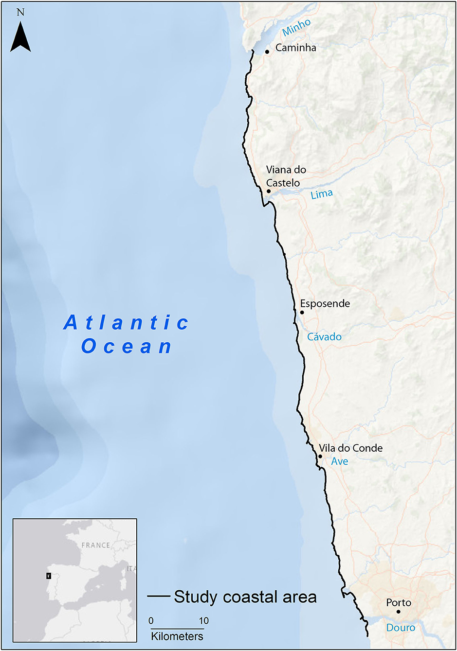
Figure 1. Location of the study area on the northern coast of Portugal.
Coastal Vulnerability Model
The Coastal Vulnerability Model of the Integrated Valuation of Environmental Services and Trade-offs, InVEST (Sharp et al., 2020), is an established Ecosystem Service (ES) model that has already been used and applied successfully in several studies (Guerry et al., 2012; Arkema et al., 2013; Langridge et al., 2014; Chung et al., 2015). This model can produce a qualitative vulnerability index for points along the coast, representing the relative exposure of the different areas to erosion and inundation during storm events based on different model inputs (Sharp et al., 2020). The model uses several variables, selected based on the most important features that could affect coastline exposure to extreme events. It includes also relevant habitat and environmental stressors information, which can be used to establish different scenarios of habitat distribution and coastal geomorphology changes. This enables managers and stakeholders to easily identify coastal areas that are at greater risk of exposure to extreme events, which can be used to inform future development scenarios and management practices.
The model uses different sources of information, namely, geomorphology of the coastal front, relief, habitat information, wind and wave data, surge potential, and SLR projections to compute a coastal Exposure Index (EI) based on the ranking of each of the inputs. Inputs are qualitatively ranked from very low exposure (rank = 1) to very high exposure (rank = 5), based on methods proposed by Gornitz (1990), and Hammar-Klose and Thieler (2001). The EI is computed as a geometric mean of all the inputs, based on following the formula:
where Ri represents the ranking of the ith input to calculate the EI at each point along the coastline (Sharp et al., 2020). The model was run at a 100-m resolution, which was enough to highlight small-scale variations in the coastal front of the study area. The relative exposure outputs of all the models of the various scenarios were represented in the following scale: Very Low (≤1), Low [(1–2)], Moderate [(2–3)], High [(3–4)], and Very High (≥4).
Data
The necessary data to run the model were gathered from pre-existent free datasets and specifically acquired local spatial data. InVEST models come with auxiliary-free global datasets that the user can apply to run the different models if no other/better data is available. Thus, we used the available data from the InVEST model to gather unavailable data for our study area, namely, the limits of the continental shelf, and the wind and wave values representing storm conditions from the Wavewatch III data. Local conditions of habitats and coastline information had to be collected for the study area. For the shoreline geomorphology vulnerability classification, we used the methodology by Gornitz (1990) and Hammar-Klose and Thieler (2001), proposed in the model documentation. This consists of characterizing the beachline front, based on substrate and other relevant features, such as the presence of estuaries or coastal protection infrastructures. Five classes were found in the area and ranked on a [1:5] scale: sand beaches, cobble beaches, rocky shores, seawalls, and estuaries. Spatial habitat distribution was gathered from multiple sources, and five main types of habitats were classified, namely, high dunes, low dunes and beaches, salt marshes, forests, and shrubs, and herbaceous vegetation. The classification of high (≥5 m) and low dunes and beaches (<5 m) was based on a high-resolution Digital Elevation Model of the study area, obtained from aerial photographs, with 15-cm resolution at ground level. Vegetation classification was based on visual assessment of orthophotos of the region and an extensive sampling survey of vegetation along the entire coastal area. The different habitat areas were digitalized in a Geographic Information System (GIS) environment, and each was assigned an exposure rank from 1 to 5, based on the scale proposed by the InVEST authors (Sharp et al., 2020). The protection distance of each habitat was evaluated based on the distance up to which each habitat can protect the coastline, determined through numerous measures along with the study site for each specific habitat (Supplementary Table 1). All the data used and their sources are provided in the Supplementary Material (Supplementary Table 2).
Scenarios
For the evaluation of the potential SLR impacts on coastal vulnerability, different scenarios were built:
i) One “Current” scenario is based on current habitat extent and sea-level conditions.
ii) Three scenarios based on IPCC Representative Concentration Pathway (RCP; IPCC, 2014) future mean SLR projections for the year 2050, namely, RCP2.6 (0.22 m), RCP4.5 (0.23 m), and RCP8.5 (0.27 m), and current extent of natural habitats.
iii) Three scenarios based on IPCC RCP future mean SLR projections for the year 2100, namely, RCP2.6 (0.44 m), RCP4.5 (0.55 m), and RCP8.5 (0.84 m), and current extent of natural habitats.
The seven scenarios described above were also evaluated without the presence of habitats, in a total of 14 different scenarios, to assess the protective role of the natural coastal ecosystems. By comparing the EI predicted with and without habitats, it was possible to quantify the protective role of coastal ecosystems under the Current scenario and also under future climate change scenarios.
Evaluating Avoided Damage to Coastal Residential Properties
To quantify the importance of EGS of coastal protection and their potential to prevent damage to properties from extreme events and erosion, we evaluated the coastal properties at risk in each of the scenarios. The value of each residential property was derived from an estimation of the residential value for buildings, considering the “median value of sales per m2 of private households (in €) by geographical location for the year 2017” of the Portuguese National Institute of Statistics (INE) as an indicator. This value was determined for two coastal risk zones prone to overflooding and overtopping for the years 2050 and 2100, respectively. The risk zones were evaluated under the current Coastal Management Program (APA, 2018), and the property value of each residence was evaluated as described in Cardona et al. (2020). The coastline was then divided into 100-m sections, corresponding to each point of the vulnerability model. Given the positive relationship between areas classified as High/Very High EI and the amount of property damage caused by coastal climate events (Cabral et al., 2017), only the segments classified as High or Very High EI were filtered out and considered for property damage valuation, as these points were at a higher risk of property damage. For these segments, the affected residences were selected, and their value was summed for each scenario.
Data Analysis
To determine if there were statistically significant differences between the EI across the different scenarios, a two-way ANOVA was performed, with Scenario and presence of Habitat as independent factors. The distribution and homoscedasticity assumptions of the data were analyzed by histograms and the Hartley Fmax test, respectively (Hartley, 1950). Because significantly different results in EI were found between Scenarios [F(6, 14,643) = 446.7, p < 0.05], and between the presence and absence of habitats [F(1, 14,643) = 2117.1, p < 0.05), a post-hoc Tukey Honest Significant Difference (HSD) analysis was performed to assess which groups were different (Supplementary Table 3). All tests used a significance level of p < 0.05.
Results
Scenarios With Habitats
Current Scenario
Results showed that in the Current scenario, 71% of the coastline understudy was classified as having a Moderate risk of erosion and flooding. Areas classified as Low risk occupy 21.2% of the coastline, while those with High EI correspond to 7.7%. No areas were classified as Very Low or Very High risk by the model (Table 1). The Esposende municipality and the northern region of the Póvoa de Varzim municipality were the coastal segments with the highest EI values in the entire coastline (Figure 2).
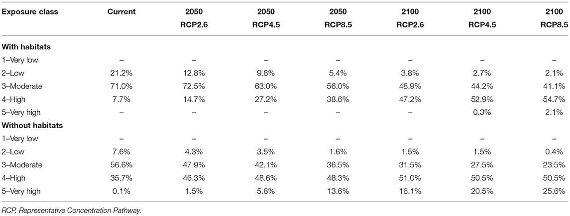
Table 1. Percentage distribution of Exposure Index values across the different RCP scenarios, and with and without habitats scenarios, across the NW of Portugal.
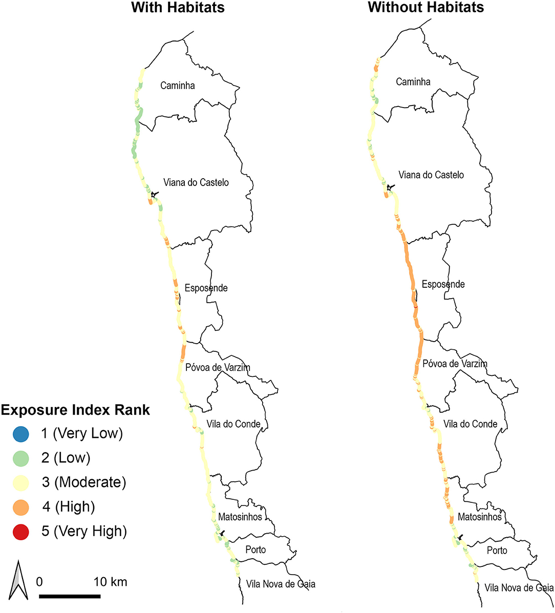
Figure 2. Exposure Index values under the Current with habitats (right) and no habitats (left) scenarios, across the northern coast of Portugal.
2050 SLR Scenarios
According to the model, climate change has a marked effect on the EI, which increased significantly with the severity of the RCP scenarios and with time. The classes most affected are the Low and High EI, with the Low EI class prevalence reduced to about a quarter and the High class increased 5-fold, for RCP8.5 by 2050, in comparison to the Current situation (Table 1; Figure 3). Except for RCP2.6, the Moderate class showed a decreasing area with increasing sea levels, with many currently Low EI class sections becoming Moderate and Moderate EI class sections becoming High.
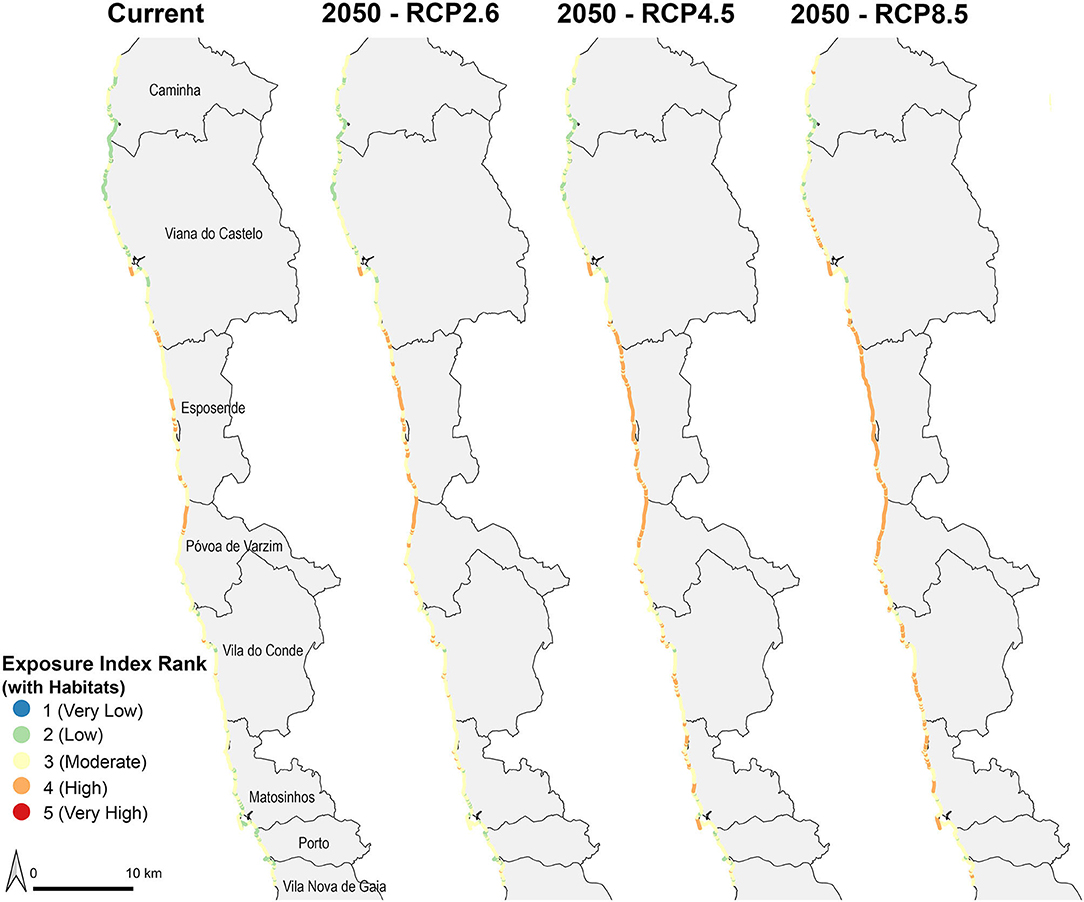
Figure 3. Exposure Index values for the Current scenario and under the different RCP scenarios for 2050 for the northern coast of Portugal, with the presence of coastal habitats. RCP, Representative Concentration Pathway.
The changes were all significant, with an increase in EI comparing the 2050 RCP2.6 scenario with the Current scenario, comparing the scenario RCP4.5 with the Current scenario and the 2050 RCP2.6 scenario and comparing the worst-case RCP8.5 scenario with the previous scenarios (Supplementary Table 3).
2100 SLR Scenarios
The pattern for the 2100 scenarios was similar but even more accentuated than for the 2050 scenarios, with the Low EI class diminishing to 10% of the Current area and the High EI class increasing 7-fold (Table 1; Figure 4). The Moderate class incidence has overall a decreasing trend with increasing sea levels. There are areas classified as Very High EI for the RCP4.5 and RCP8.5, a class that did not exist for the Current and 2050 scenarios.
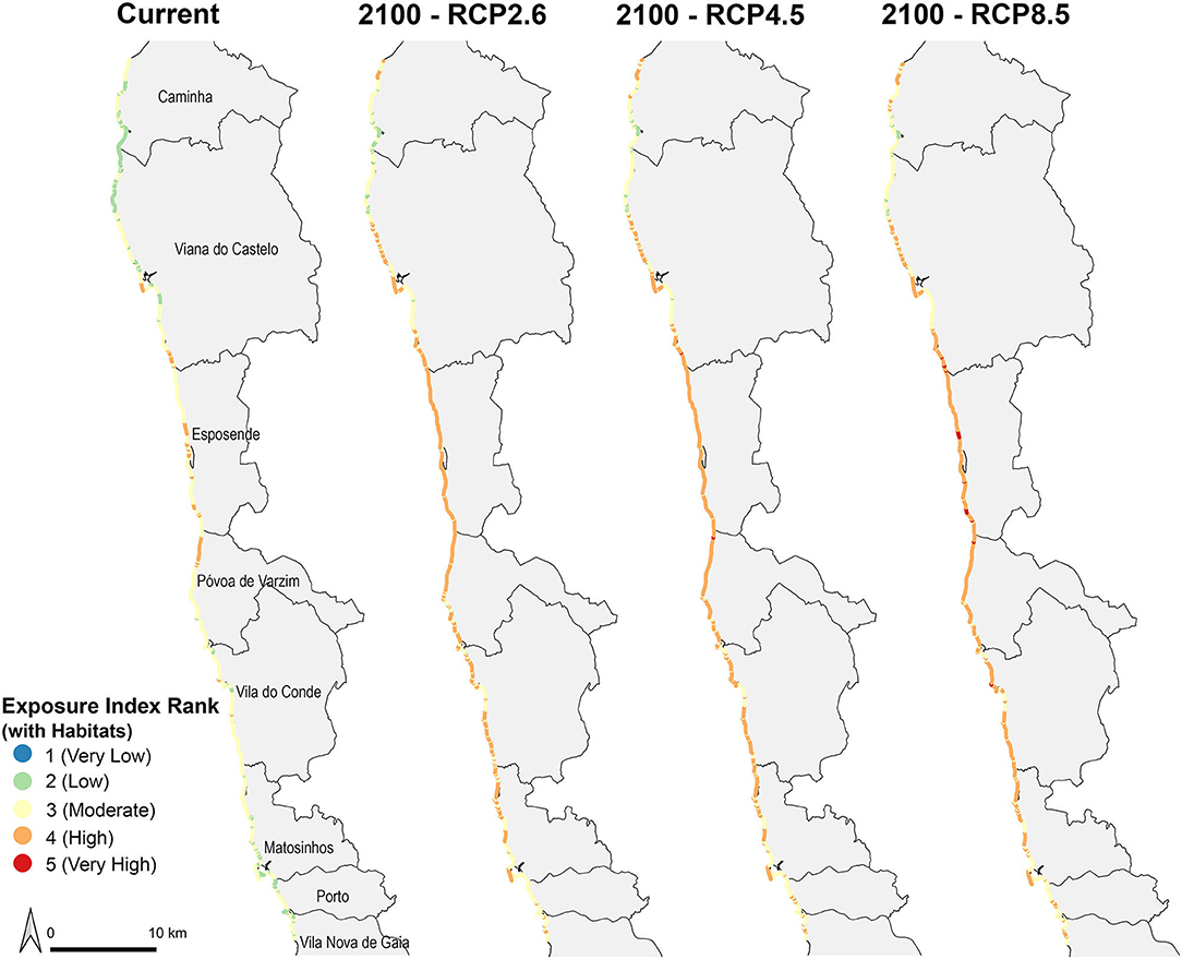
Figure 4. Exposure Index values for the Current scenario and under the different RCP scenarios for 2100 for the northern coast of Portugal, with the presence of coastal habitats. RCP, Representative Concentration Pathway.
The EI along the entire coastline increased significantly comparing the 2100 RCP2.6 scenario with the Current scenario, comparing the RCP4.5 scenario with the Current scenario and with the 2100 RCP2.6 scenario, and comparing the RCP8.5 scenario with the Current and 2100 RCP2.6 scenarios. However, the predicted EI for RCP8.5 was not significantly higher than that for scenario 2100 RCP4.5 (Supplementary Table 3).
Scenarios Without Habitats
Current Scenario
Considering the Current scenario without habitats, there was a significant increase in the EI value when compared to the Current scenario with habitats (Supplementary Table 3). In this scenario, the High-risk area is almost 5-fold than that of the Current scenario with habitats. This is accompanied by a marked decrease in the Low and Moderate EI classes. In this scenario, almost the whole coastal stretch between Viana do Castelo and Matosinhos municipalities was classified as having a High EI (Figure 2). There is a small area with Very High-risk EI.
2050 SLR Scenarios
Analogously to the model outputs for scenarios with habitats, climate change showed a marked effect on the EI, which increased significantly with the severity of the RCP scenarios and with time (Supplementary Table 3). However, without habitats, the predicted risk was already high for the Current scenario and SLR effects became less accentuated. The Low EI class prevalence reduced to about a fifth and the Moderate class lost a third of its area, for RCP8.5 by 2050, in comparison to the Current situation (Table 1; Figure 5). The High and, particularly, the Very High-risk classes increased in the area.

Figure 5. Exposure Index values for the Current scenario and under the different RCP scenarios for 2050 for the northern coast of Portugal, without the contribution of coastal habitats. RCP, Representative Concentration Pathway.
The overall EI across the entire coastline was significantly higher comparing the RCP2.6 scenario with the Current scenario and the 2050 RCP2.6 scenario with habitats, comparing the RCP4.5 scenario with the previous scenarios without habitats and with the RCP4.5 scenario with habitats, and comparing the RCP8.5 scenario with the previous scenarios without habitats and with the RCP8.5 with habitats scenario (Supplementary Table 3).
2100 SLR Scenarios
Without habitats, the 2100 scenarios showed nearly no Low risk, decreasing Moderate risk, stable High risk (occupying about half of the area), and markedly increasing Very High-risk areas. By 2100, three-quarters of the coastline are classified as High or Very High EI, considering the worst-case scenario RCP8.5 (Table 1; Figure 6).
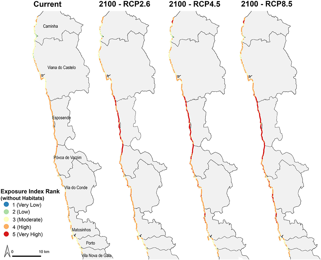
Figure 6. Exposure Index values for the Current scenario and under the different RCP scenarios for 2100 for the northern coast of Portugal, without the contribution of coastal habitats. RCP, Representative Concentration Pathway.
The overall EI across the entire coastline was significantly higher comparing the RCP2.6 scenario with the previous Current scenario and with the 2100 RCP2.6 scenario with habitats. EI was also significantly higher comparing the RCP4.5 scenario with the Current scenario without habitats and the same RCP4.5 scenario but with habitats, but not significantly higher compared to the 2100 RCP8.5 without habitats. The RCP8.5 scenario showed significantly higher EI values than those for the Current scenario without habitats and for the same 2100 RCP8.5 scenario but with habitats, but not significantly higher values than those for the previous 2100 RCP4.5 scenario without habitats (Supplementary Table 3).
Overall, these results showed that the presence of natural coastal habitats significantly decreased the EI in the coastal area in all the scenarios evaluated. Particularly, in reducing the overall percentage of areas classified as High or Very High EI in future SLR scenarios. In the Current scenario, the presence of habitats was responsible for a reduction of 28% in the areas classified as High or Very High EI. Comparing the model results of SLR scenarios, with and without habitats, a reduction of 9.7% in areas classified as High EI, and of 13.6% in areas classified with Very High EI was observed, when comparing the model results for scenario2050 RCP8.5 with and without habitats. For the year 2100 RCP8.5 scenarios, the existence of habitats reduced the occurrence of areas classified by the model as High by 4% and as Very High by 23.52%.
Residential Property Damage Prevention
The results showed that the amount of potential damage to residential property caused by extreme events increased with increasing severity of the environmental changes modeled, in areas with High or Very High EI values. Under the Current scenario with habitats, the potential residential property damage from one extreme event could reach nearly 9 million Euros (M€) (Figure 7). On the other hand, considering the absence of habitats, the value of residential property damage could reach approximately 115 M€, representing a potential residential property damage cost prevention difference of 105 M€ through EGS.
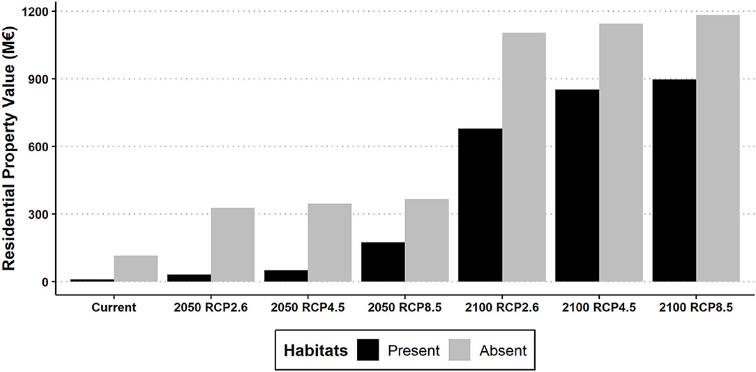
Figure 7. Total potential residential property damage value (2017 value in millions of Euros–M€) in areas with High and Very High Exposure Index values under each RCP and habitat scenarios for the years 2050 and 2100 in the northern coast of Portugal. RCP, Representative Concentration Pathway.
For the year 2050, values showed that, with habitats present, the potential damage for residential property in one extreme event could rise to 31.4 M€ in the scenario RCP 2.6, 50 M€ in the scenario RCP4.5, and to 173 M€ in the scenario RCP8.5 scenario. Without the protection of the natural habitats, the values of residential property damages rise to 327 M€ in the scenario RCP2.6, 346 M€ in the scenario RCP4.5, and 366 M€ in scenario RCP8.5 (Figure 7).
For the year 2100, the potential value of residential property damage considering the scenarios with habitats were 680 M€ in the scenario RCP2.6, 852 M€ in the scenario RCP4.5, and 897 M€ in the scenario RCP8.5. In the absence of habitats, these values could rise to 1,104 M€ in the scenario RCP2.6, to 1,145 M€ in the scenario RCP4.5, and 1,182 M€ in the scenario RCP8.5.
Overall, these results showed that considering the worst SLR scenario (RCP8.5), the current ES of coastal protection against extreme events offered by the existing natural habitats could reduce the potential damage to residential property by 192 M€ for the year 2050 and 285 M€ for the year 2100.
Discussion
This study provides an evaluation and quantification in terms of prevented damage to properties of how coastal ecosystems, such as sand beaches and dunes, can protect coastal communities in Current and future scenarios of SLR and extreme events. The significant differences found in the EI between the Current and future scenarios, with and without habitats, showed the importance of these ecosystems in decreasing the exposure of coastal shores to extreme events and erosion phenomena. The presence of sand beaches and dunes notably decreased the EI throughout the northern coastal area of Portugal and lowered the potential damage from erosive and flooding events to residential property, particularly considering future SLR scenarios. Considering the projections of SLR, results showed that even with the presence of protective coastal habitats, some areas are still under a high risk of vulnerability, putting further pressure on managers and decision-makers. This stresses the importance of conservation and, most importantly, the implementation of recovery plans for coastal ecosystems. These ecosystems have not only the potential to increase coastal protection and resilience to storm events and flooding, and thus lower economic losses for local communities from extreme weather events, but also to increase the delivery of other ESs provided by these coastal ecosystems. Important services, such as carbon sequestration in saltmarshes, kelp forests and coastal dunes, provision of habitat for species and increased biodiversity, or recreation and well-being, can also be improved with the restoration of these ecosystems (Everard et al., 2010; Barbier et al., 2011; Van der Biest et al., 2017).
Current Scenario
The InVEST model was able to identify the coastal areas most vulnerable to storm events and flooding, located predominantly in the region between the Lima and Ave rivers. These results support previous studies and agree with the general knowledge of the region (APA, 2018). The coastal stretch between the estuaries of the rivers Lima and Ave is recognized as one of the most vulnerable coastal stretches in the region (Veloso-Gomes, 2007). Several environmental factors contribute to the high vulnerability of this region, such as low reliefs, habitat fragmentation of dunes at some locations, and higher wind and wave force conditions. Also, in many areas of the region, only small strips of sandy beaches are present, due to sediment depletion, as a result of poor sediment availability and neglected management in the past (Pinto, 2004), that promoted beach thinning and a reduced ability of the beach and dune system to protect the coastal front. This reduces beach and dune capacity to withstand storm events and avoid inundation of coastal strips, and subsequent storm damages. Moreover, this narrowing of sand dunes hampers the natural development of established dune systems, compromising the natural expansion of dune ecosystems, and avoids the formation of young dunes that could serve as a basis for a stronger dune system in the future.
Additionally, the region is a popular location for leisure and tourism, with many urban seafronts and high pressure from anthropogenic uses and economic activities, particularly in the central and southern areas of the study region. The urban development so close to the beachline largely contributes to the high vulnerability of the residential properties to extreme events, as this study showed. In addition, the high numbers of people that use the beaches increase the trampling damage to the dune system, promoting additional stresses to the dune system and the degradation of the dune vegetation, and increasing the risk of further dune erosion. Vegetation plays a key role in the maintenance of the different coastal ecosystems, with their role in the recovery process been demonstrated in studies based on post storm surveys (Ellis and Román-Rivera, 2019). Vegetated dune systems reduce water flow velocity, lessening the impacts of storm surge, and wave forces to coastal fronts. Dune vegetation also traps sediments that aid the formation of incipient dunes, which help with post-storm dune recovery and backshore accretion, being important to control maximum dune size (Thom and Hall, 1991; Hesp, 2002; Durán and Moore, 2013; Fernández-Montblanc et al., 2020; Charbonneau et al., 2021).
In the Current scenario, the presence of habitats contributed to potential property damage savings of around 105 M€ in case of extreme events, primarily in the municipalities of Esposende, Vila do Conde, Póvoa de Varzim, and Matosinhos. It was in these regions that the presence of the habitats was most important in reducing the vulnerability of the coastline and coastal property to extreme events (Figure 2). Nonetheless, we could observe that even considering the maintenance of the current occupation by coastal natural habitats, the area still faces higher vulnerability to extreme events. Areas classified with Low EI occurred mostly in northern and southern segments of the studied coastline (Figure 2). The northern region of the study area, between the rivers Minho and Lima, is mainly characterized by rocky shorelines and higher reliefs, promoting a coastline more resilient and less prone to erosion. This effect was observed in the EI model results, despite the higher wave forces present in this area, which decrease from north to south along the NW Portuguese coast (Silva et al., 2018). The region north of the Lima estuary is less urbanized, mainly covered by agriculture and patches of forest occurring near the coast. In the southern area of the study region, a highly urbanized or industrial shorefront, higher reliefs, and the presence of rocky shores, also explain the lower EI obtained in this region.
The comparison of the results of the study with and without habitats showed that removing habitat extent significantly increased the occurrence of High and Very High EI areas (Figures 2–5, 7), similar to other results evaluating coastal vulnerability (Arkema et al., 2013; Spalding et al., 2014; Cabral et al., 2017). For example, Cabral et al. (2017) found that removing the habitats from the modeled scenarios increased by 34.4% the presence of High or Very High segments in their study of the Mozambique coast. A study by Hopper and Meixler (2016) also found a higher frequency of higher EI values when habitats were not present. In our study, the reduction in 28% of areas classified as High or Very High due to the presence of habitats, such as beaches and sand dunes, found for the Current scenario, illustrates the important role that natural habitats play in reducing the exposure of the coastline to flooding and erosive events. Results also showed that even with the presence of degraded dune systems in some locations and the patchy distribution of dune vegetation, these ecosystems were still able to considerably decrease coastal vulnerability levels.
Future SLR Scenarios
The presence of coastal natural habitats reduced the exposure of the coastline to extreme events in all the future scenarios evaluated (Table 1). However, the current vulnerability of the coastline to environmental stressors is also reflected in the future-modeled scenarios, with higher increases in vulnerability and, consequently, in potential property damage. Even with the presence of coastal habitats, nearly 40% of the coastline of the region was assigned to the High vulnerability class for the 2050 RCP8.5 scenario, and that area further increased to nearly 60% for the scenario 2100 RCP8.5. The central municipalities of the region are expected to see their vulnerability increase with the increasing severity of the modeled scenarios. Particularly, the municipalities of Esposende, Póvoa de Varzim, and Vila do Conde could have their entire coastline classified as Highly or Very Highly vulnerable to environmental stressors.
In the scenarios without habitats, we can see the increase of the coastline vulnerability to environmental stressors, with more coastal segments assigned to the Very High vulnerability class. This is particularly serious in the case of Esposende where almost all the coastline falls under the Very High vulnerability class (Figures 4, 5). In these scenarios, the potential damage to coastal property increases dramatically for the extreme SLRs. In case of an extreme event, we could see the damage to coastal property reaching nearly 900 M€ for the 2100 RCP8.5 scenario. This reflects the increased number of coastal segments under higher levels of Exposure near coastal urban fronts, which in turn augment the potential future damages to coastal residential property.
The presence of habitats was responsible for 285 M€ of potential property damage savings in this scenario, 2100 RCP8.5 scenario, not considering future variations in property values or modifications to current habitat distribution. In our study, the natural coastal habitats reduced the occurrence of High or Very High EI areas by 13.6% by 2050 and 23.52% by 2100, in the worst-case scenario (RCP8.5). Other studies looking into the protective capacity of coastal habitats also highlight their importance to protect coastal communities against storm events. For example, Arkema et al. (2013) evaluated the protection of property from storms and SLR in high exposure areas in Florida for US$80 billion, while Costanza et al. (2008) estimated a $7,879.50 per ha per year storm protection for wetlands in Florida. Sigren et al. (2018) found that the presence of dunes helped reduce the amount of property damage by an estimated $8 million following Hurricane Ike in 2008. In our study, the detailed evaluation performed by Cardona et al. (2020), based on local data, provides support to consider that the economic valuation performed reflects the real cost of potential damage avoided in case of an extreme event affecting the properties in the study area.
Results reflect the importance of coastal habitats in protecting the coastline against environmental phenomena and the need to develop restoration and improvement initiatives for these natural buffers and to incorporate them into management plans. Coastal natural ecosystems have intrinsic characteristics that give them resilience to cope with environmental and climate changes. For example, small storms cause less damage in ecosystems than in hard infrastructures, since the ecosystems have the capacity to self-recover after storm events, in contrast with non-living infrastructures (Sutton-Grier et al., 2015). Moreover, once established they have the capacity to develop a stronger resilience over time (Nicholls et al., 2007). For example, in the case of sand dunes and salt marshes, it is important to refer to their capacity to cope with SLR, if enough space is available for their natural dynamic movement, and if accretion rates within these ecosystems are sufficient to allow them to overcome the SLR (Konlechner et al., 2019; Bazzichetto et al., 2020).
This study highlights the importance of coastal habitats in decreasing coastal vulnerability and decrease the potential damage inflicted to the coastal property by erosion and storms events. Additionally, results showed that even degraded existent coastal dunes and beaches were still able to reduce the vulnerability of the coastal area, stressing the importance of restoration plans to increase the resilience of coastal areas to flooding by storms. This information is extremely decisive to stakeholders for the implementation of mitigation and protective measures. To cope with the expected increase in SLR, a combination of approaches should be applied, where the participation and commitment at different institutional levels and of communities will have to be integrated. The protection and prevention of further damage to the existent habitats should be the aim for the long-term stability of the ecosystems, and restoration should be targeted to areas classified with High or Very High vulnerability. That could be integrated with more traditional hard structures and planned retreats to help avoid future additional property and societal damages and promote healthy coastal ecosystems with the necessary conditions to evolve and cope with an increasing SLR.
Limitations of the Model
Despite being a free and useful tool for an initial assessment to evaluate the vulnerability of coastal segments to storm-induced erosion and flooding, the Coastal Vulnerability Model has some limitations, as stated in the model documentation (Sharp et al., 2020). Coastal erosion is a complex problem, where multiple processes occur at the same time, and it is important to recognize that the variety of co-occurring processes cannot be fully represented based on the variables used in this model, with a simplified index computed as a geometric mean of the different variables (Sharp et al., 2020). For example, the model excludes any complex hydrodynamic or sediment processes that occur in coastal areas (Sharp et al., 2020). In this work, we also assumed that the delivery of the protective contribution of coastal habitats in reducing exposure will remain the same through space and time, not considering the natural variability of the ecosystem and the positive or negative effects that environmental changes can introduce in the delivery of EGS. Nonetheless, the Coastal Vulnerability model allows coastal managers and decision-makers to quickly assess the issue and provides an initial overview of the vulnerability and overall situation, allowing the assessment of management decision options without many resources or technical expertise.
Conclusions
The ES of coastal protection is probably one of the most important services in coastal areas given the currently expected scenarios of SLR and increased climate variability that brings higher risks to coastal communities. The results of this study highlight the importance of local coastal habitats in decreasing coastal vulnerability to storm-induced erosion and flooding. We showed that natural coastal habitats, such as dunes, are responsible for a significant reduction in coastal exposure and potential residential property damage.
The expected SLR within the IPCC scenarios would increase the vulnerability of the region to extreme events, particularly in the already vulnerable central region of the study area. By 2100 in the RCP8.5 scenario, more than half of the studied coastline would be seriously threatened (under High or Very High exposure). The role of coastal habitats was crucial in the modeled scenarios, reducing exposure significantly and potentially leading to savings of up to 300 M€, for the most extreme scenario for 2100. The potentially avoided residential property losses showed in this study could be an incentive to managers and local stakeholders to integrate more “working with nature” solutions within coastal management plans, promoting the rehabilitation and extension of natural coastal habitats that can serve as a buffer against coastal storms and extreme events.
The results of this work could provide local authorities with data on areas most vulnerable to coastal erosion and enable them to evaluate where the implementation of recovery plans, and the development of ecosystem-based approaches for coastal habitats, could have the most benefits in protecting coastal communities and coastal property and in reducing future potential costs to society.
Data Availability Statement
The original contributions presented in the study are included in the article/Supplementary Material, further inquiries can be directed to the corresponding author.
Author Contributions
JC: conceptualization, methodology, software, validation, formal analysis, investigation, visualization, data curation, writing—original draft preparation, and writing—reviewing and editing. FC: resources and writing—reviewing and editing. AB: resources, writing—original draft preparation, writing—reviewing and editing, funding acquisition, and project administration. SR: conceptualization, methodology, investigation, validation, visualization, resources, writing—reviewing and editing, funding acquisition, project administration, and supervision. All authors contributed to the article and approved the submitted version.
Funding
This research was partially supported by the project OCEAN3R–Reduce pressures, restore and regenerate the NW-Portuguese ocean and waters, com a referência NORTE-01-0145-FEDER-000064, co-funded by Programa Operacional Regional do Norte (NORTE 2020), through Portugal 2020 and Fundo Europeu de Desenvolvimento Regional (FEDER), by national funds through FCT–Foundation for Science and Technology within the scope of UIDB/04423/2020 and UIDP/04423/2020; and by JC Ph.D. fellowship from FCT (ref. PD/BD/150359/2019, co-financed by FSE through Programa Operacional Regional Norte).
Conflict of Interest
The authors declare that the research was conducted in the absence of any commercial or financial relationships that could be construed as a potential conflict of interest.
Publisher's Note
All claims expressed in this article are solely those of the authors and do not necessarily represent those of their affiliated organizations, or those of the publisher, the editors and the reviewers. Any product that may be evaluated in this article, or claim that may be made by its manufacturer, is not guaranteed or endorsed by the publisher.
Acknowledgments
The authors would like to acknowledge the MarRISK project- Adaptación costera ante el Cambio Climático: conocer los riesgos y aumentar la resiliencia (0262_MarRISK_1_E), funded by EP INTERREG V A España-Portugal (POCTEP) program, for providing data for this study.
Supplementary Material
The Supplementary Material for this article can be found online at: https://www.frontiersin.org/articles/10.3389/fmars.2021.726145/full#supplementary-material
References
Arkema, K. K., Guannel, G., Verutes, G., Wood, S. A., Guerry, A., Ruckelshaus, M., et al. (2013). Coastal habitats shield people and property from sea-level rise and storms. Nat. Clim. Change 3, 913–918. doi: 10.1038/nclimate1944
Barbier, E. B. (2013). Valuing ecosystem services for coastal wetland protection and restoration: progress and challenges. Resources 2, 213–230. doi: 10.3390/resources2030213
Barbier, E. B. (2019). “Chapter 27: the value of coastal wetland ecosystem services,” in Coastal Wetlands, eds G. M. E. Perillo, E. Wolanski, D. R. Cahoon, and C. S. Hopkinson (Elsevier), 947–964. doi: 10.1016/B978-0-444-63893-9.00027-7
Barbier, E. B., Hacker, S. D., Kennedy, C., Koch, E. W., Stier, A. C., and Silliman, B. R. (2011). The value of estuarine and coastal ecosystem services. Ecol. Monogr. 81, 169–193. doi: 10.1890/10-1510.1
Barragán, J. M., and de Andrés, M. (2015). Analysis and trends of the world's coastal cities and agglomerations. Ocean Coast. Manag. 114, 11–20. doi: 10.1016/j.ocecoaman.2015.06.004
Bazzichetto, M., Sperandii, M. G., Malavasi, M., Carranza, M. L., and Acosta, A. T. R. (2020). Disentangling the effect of coastal erosion and accretion on plant communities of Mediterranean dune ecosystems. Estuarine Coast Shelf Sci. 241:106758. doi: 10.1016/j.ecss.2020.106758
Beck, M. W., Losada, I. J., Menéndez, P., Reguero, B. G., Díaz-Simal, P., and Fernández, F. (2018). The global flood protection savings provided by coral reefs. Nat. Commun. 9, 1–9. doi: 10.1038/s41467-018-04568-z
Cabral, P., Augusto, G., Akande, A., Costa, A., Amade, N., Niquisse, S., et al. (2017). Assessing Mozambique's exposure to coastal climate hazards and erosion. Int. J. Disas. Risk Reduct. 23, 45–52. doi: 10.1016/j.ijdrr.2017.04.002
Cardona, F., Ferreira, J. C., and Lopes, A. M. (2020). Relatório de análises custo benefício e propostas estruturais de resiliência para o edificado em risco. Projeto INTERREG/MarRISK, Atividade 3, Ação 12. Proyecto: 0262_MARRISK_1_E. Lisboa: Agência Portuguesa do Ambiente.
Charbonneau, B. R., Dohner, S. M., Wnek, J. P., Barber, D., Zarnetske, P., and Casper, B. B. (2021). Vegetation effects on coastal foredune initiation: Wind tunnel experiments and field validation for three dune-building plants. Geomorphology 378:107594. doi: 10.1016/j.geomorph.2021.107594
Chung, M. G., Kang, H., and Choi, S.-U. (2015). Assessment of coastal ecosystem services for conservation strategies in South Korea. PLoS ONE 10:e0133856. doi: 10.1371/journal.pone.0133856
Costanza, R., Pérez-Maqueo, O., Martinez, M. L., Sutton, P., Anderson, S. J., and Mulder, K. (2008). The value of coastal wetlands for hurricane protection. Ambio 37, 241–248. doi: 10.1579/0044-7447(2008)37[241:tvocwf]2.0.co;2
Duarte, C. M., Losada, I. J., Hendriks, I. E., Mazarrasa, I., and Marb,à, N. (2013). The role of coastal plant communities for climate change mitigation and adaptation. Nat. Clim. Change 3, 961–968. doi: 10.1038/nclimate1970
Durán, O., and Moore, L. J. (2013). Vegetation controls on the maximum size of coastal dunes. PNAS 110, 17217–17222. doi: 10.1073/pnas.1307580110
Ellis, J. T., and Román-Rivera, M. A. (2019). Assessing natural and mechanical dune performance in a post-hurricane environment. J. Mar. Sci. Eng. 7:126. doi: 10.3390/jmse7050126
Everard, M., Jones, L., and Watts, B. (2010). Have we neglected the societal importance of sand dunes? An ecosystem services perspective. Aquatic Conserv. 20, 476–487. doi: 10.1002/aqc.1114
Feagin, R. A., Figlus, J., Zinnert, J. C., Sigren, J., Martínez, M. L., Silva, R., et al. (2015). Going with the flow or against the grain? The promise of vegetation for protecting beaches, dunes, and barrier islands from erosion. Front. Ecol. Environ. 13, 203–210. doi: 10.1890/140218
Feagin, R. A., Furman, M., Salgado, K., Martinez, M. L., Innocenti, R. A., Eubanks, K., et al. (2019). The role of beach and sand dune vegetation in mediating wave run up erosion. Estuarine Coast. Shelf Sci. 219, 97–106. doi: 10.1016/j.ecss.2019.01.018
Fernández-Montblanc, T., Duo, E., and Ciavola, P. (2020). Dune reconstruction and revegetation as a potential measure to decrease coastal erosion and flooding under extreme storm conditions. Ocean Coast. Manag. 188:105075. doi: 10.1016/j.ocecoaman.2019.105075
Gómez-Pina, G., Muñoz-Pérez, J. J., Ramírez, J. L., and Ley, C. (2002). Sand dune management problems and techniques, Spain. J. Coast. Res. 36, 325–332. doi: 10.2112/1551-5036-36.sp1.325
Gornitz, V. (1990). Vulnerability of the east coast, U.S.A. to future sea level rise. J. Coastal Res. 9, 201–237.
Gracia, A., Rangel-Buitrago, N., Oakley, J. A., and Williams, A. T. (2018). Use of ecosystems in coastal erosion management. Ocean Coast. Manag. 156, 277–289. doi: 10.1016/j.ocecoaman.2017.07.009
Guerry, A. D., Ruckelshaus, M. H., Arkema, K. K., Bernhardt, J. R., Guannel, G., Kim, C.-K., et al. (2012). Modeling benefits from nature: using ecosystem services to inform coastal and marine spatial planning. Int. J. Biodiv. Sci. Ecosyst. Serv. Manag. 8, 107–121. doi: 10.1080/21513732.2011.647835
Hammar-Klose, E. S., and Thieler, E. R. (2001). Coastal Vulnerability to Sea-Level Rise: a Preliminary Database for the U.S. Atlantic, Pacific, and Gulf of Mexico Coasts (Report No. 68), Data Series (Woods Hole, MA).
Hartley, H. O. (1950). The maximum F-ratio as a short cut test for homogeneity of variance. Biometrika 37, 308–312.
Hassan, R.M., Scholes, R.J., Ash, N., and Millennium Ecosystem Assessment (Program) (Eds.). (2005). Ecosystems and Human Well-Being: Current State and Trends: Findings of the Condition and Trends Working Group of the Millennium Ecosystem Assessment, The Millennium Ecosystem Assessment Series. Washington, DC: Island Press.
Hesp, P. (2002). “Foredunes and blowouts: initiation, geomorphology and dynamics,” in Geomorphology, 29th Binghamton Geomorphology Symposium: Coastal Geomorphology, Vol. 48 (New York, NY), 245–268. doi: 10.1016/S0169-555X(02)00184-8
Hinkel, J., Lincke, D., Vafeidis, A. T., Perrette, M., Nicholls, R. J., Tol, R. S. J., et al. (2014). Coastal flood damage and adaptation costs under 21st century sea-level rise. Proc. Natl. Acad. Sci. U.S.A. 111, 3292–3297. doi: 10.1073/pnas.1222469111
Hopper, T., and Meixler, M. S. (2016). Modeling coastal vulnerability through space and time. PLoS ONE 11:e0163495. doi: 10.1371/journal.pone.0163495
Horstman, E. M., Dohmen-Janssen, C. M., Narra, P. M. F., van den Berg, N. J. F., Siemerink, M., and Hulscher, S. J. M. H. (2014). Wave attenuation in mangroves: A quantitative approach to field observations. Coast. Eng. 94, 47–62. doi: 10.1016/j.coastaleng.2014.08.005
IPCC (2014). Climate Change 2014: Synthesis Report. Contribution of Working Groups I, II and III to the Fifth Assessment Report of the Intergovernmental Panel on Climate Change. Geneva: IPCC, 151.
Jackson, N. L., and Nordstrom, K. F. (2018). Aeolian sediment transport on a recovering storm-eroded foredune with sand fences. Earth Surf. Proc. Landforms 43, 1310–1320. doi: 10.1002/esp.4315
Konlechner, T. M., Kennedy, D. M., Cousens, R. D., and Woods, J. L. D. (2019). Patterns of early-colonising species on eroding to prograding coasts; implications for foredune plant communities on retreating coastlines. Geomorphology 327, 404–416. doi: 10.1016/j.geomorph.2018.11.013
Kumar, L., and Taylor, S. (2015). Exposure of coastal built assets in the South Pacific to climate risks. Nat. Clim. Change 5, 992–996. doi: 10.1038/nclimate2702
Langridge, S. M., Hartge, E. H., Clark, R., Arkema, K., Verutes, G. M., Prahler, E. E., et al. (2014). Key lessons for incorporating natural infrastructure into regional climate adaptation planning. Ocean Coast. Manag. 95, 189–197. doi: 10.1016/j.ocecoaman.2014.03.019
Marinho, B., Coelho, C., Hanson, H., and Tussupova, K. (2019). Coastal management in Portugal: practices for reflection and learning. Ocean Coast. Manag. 181:104874. doi: 10.1016/j.ocecoaman.2019.104874
Menéndez, P., Losada, I. J., Torres-Ortega, S., Narayan, S., and Beck, M. W. (2020). The global flood protection benefits of mangroves. Sci. Rep. 10, 1–11. doi: 10.1038/s41598-020-61136-6
Neumann, B., Vafeidis, A. T., Zimmermann, J., and Nicholls, R. J. (2015). Future coastal population growth and exposure to sea-level rise and coastal flooding - a global assessment. PLoS ONE 10:e0118571. doi: 10.1371/journal.pone.0118571
Nicholls, R. J., Wong, P. P., Burkett, V., Codignotto, J., and Hay, J. (2007). “Coastal systems and low-lying areas,” in Climate Change 2007: Impacts, Adaptation and Vulnerability. Contribution of Working Group II to the Fourth Assessment Report of the Intergovernmental Panel on Climate Change, eds M. L. Parry, O. F. Canziani, J. P. Palutikof, P. J. van der Linden, and C. E. Hanson (Cambridge: Cambridge University Press), 315–356.
Paprotny, D., Terefenko, P., Giza, A., Czapliński, P., and Vousdoukas, M. I. (2021). Future losses of ecosystem services due to coastal erosion in Europe. Sci, Total Environ. 760:144310. doi: 10.1016/j.scitotenv.2020.144310
Pinto, F. T. (2004). The practice of coastal zone management in Portugal. J. Coast. Conserv. 10, 147–157. doi: 10.1652/1400-0350(2004)010[0147:TPOCZM]2.0.CO;2
Pranzini, E. (2018). Shore protection in Italy: From hard to soft engineering … and back. Ocean Coast. Manag. 156, 43–57. doi: 10.1016/j.ocecoaman.2017.04.018
Rangel-Buitrago, N. G., Anfuso, G., and Williams, A. T. (2015). Coastal erosion along the Caribbean coast of Colombia: magnitudes, causes and management. Ocean Coast. Manag. 114, 129–144. doi: 10.1016/j.ocecoaman.2015.06.024
Ruggiero, P., Hacker, S., Seabloom, E., and Zarnetske, P. (2018). “The role of vegetation in determining dune morphology, exposure to sea-level rise, and storm-induced coastal hazards: a U.S. Pacific northwest perspective,” in Barrier Dynamics and Response to Changing Climate, eds L. J. Moore and A. B. Murray (Cham: Springer International Publishing), 337–361. doi: 10.1007/978-3-319-68086-6_11
Santos, F. D., Lopes, A. M., Moniz, G., Ramos, L., and Taborda, R. (2017). “Caracterização da Zona Costeira de Portugal Continental,” in Grupo de Trabalho do Litoral: Gestão da Zona Costeira: O desafio da mudança, eds G. Penha-Lopes and A. M. Lopes (Lisboa), 396.
Sharp, R., Douglass, J., Wolny, S., Arkema, K., Bernhardt, J., Bierbower, W., et al. (2020). InVEST User's Guide. The Natural Capital Project; Stanford University; University of Minnesota; The Nature Conservancy; World Wildlife Fund, 307.
Sigren, J. M., Figlus, J., Highfield, W., Feagin, R. A., and Armitage, A. R. (2018). The effects of coastal dune volume and vegetation on storm-induced property damage: analysis from Hurricane Ike. Coas 34, 164–173. doi: 10.2112/JCOASTRES-D-16-00169.1
Silva, D., Martinho, P., and Guedes Soares, C. (2018). Wave energy distribution along the Portuguese continental coast based on a thirty three years hindcast. Renew. Energy 127, 1064–1075. doi: 10.1016/j.renene.2018.05.037
Spalding, M. D., Ruffo, S., Lacambra, C., Meliane, I., Hale, L. Z., Shepard, C. C., et al. (2014). The role of ecosystems in coastal protection: adapting to climate change and coastal hazards. Ocean Coast. Manag. 90, 50–57. doi: 10.1016/j.ocecoaman.2013.09.007
Sutton-Grier, A. E., Wowk, K., and Bamford, H. (2015). Future of our coasts: The potential for natural and hybrid infrastructure to enhance the resilience of our coastal communities, economies and ecosystems. Environ. Sci. Policy 51, 137–148. doi: 10.1016/j.envsci.2015.04.006
Syvitski, J. P. M., Vörösmarty, C. J., Kettner, A. J., and Green, P. (2005). Impact of humans on the flux of terrestrial sediment to the global coastal ocean. Science 308, 376–380. doi: 10.1126/science.1109454
Teagle, H., Hawkins, S. J., Moore, P. J., and Smale, D. A. (2017). The role of kelp species as biogenic habitat formers in coastal marine ecosystems. J. Exp. Mar. Biol. Ecol. 492, 81–98. doi: 10.1016/j.jembe.2017.01.017
Thom, B. G., and Hall, W. (1991). Behaviour of beach profiles during accretion and erosion dominated periods. Earth Surf. Proc. Landforms 16, 113–127. doi: 10.1002/esp.3290160203
Van der Biest, K., De Nocker, L., Provoost, S., Boerema, A., Staes, J., and Meire, P. (2017). Dune dynamics safeguard ecosystem services. Ocean Coast. Manag. 149, 148–158. doi: 10.1016/j.ocecoaman.2017.10.005
van Rijn, L. C. (2011). Coastal erosion and control. Ocean Coast. Manag. Concepts Sci. Coast. Eros. Manag. 54, 867–887. doi: 10.1016/j.ocecoaman.2011.05.004
Veloso-Gomes, F. (2007). A gestão da zona costeira portuguesa. Rev. Gestão Cost. Integr. 7, 83–95. doi: 10.5894/rgci19
Vousdoukas, M. I., Ranasinghe, R., Mentaschi, L., Plomaritis, T. A., Athanasiou, P., Luijendijk, A., and Feyen, L. (2020). Sandy coastlines under threat of erosion. Nat. Clim. Chang. 10, 260–263. doi: 10.1038/s41558-020-0697-0
Vuik, V., Jonkman, S. N., Borsje, B. W., and Suzuki, T. (2016). Nature-based flood protection: The efficiency of vegetated foreshores for reducing wave loads on coastal dikes. Coast. Eng. 116, 42–56. doi: 10.1016/j.coastaleng.2016.06.001
Williams, A. T., Rangel-Buitrago, N., Pranzini, E., and Anfuso, G. (2018). The management of coastal erosion. Ocean Coast. Manag. 156, 4–20. doi: 10.1016/j.ocecoaman.2017.03.022
Zedler, J. B., and Kercher, S. (2005). WETLAND RESOURCES: Status, Trends, Ecosystem Services, and Restorability. Annu. Rev. Environ. Resour. 30, 39–74. doi: 10.1146/annurev.energy.30.050504.144248
Keywords: coastal ecosystem services, coastal protection, coastal management, sea level rise (SLR), Northern Portugal
Citation: Cunha J, Cardona FS, Bio A and Ramos S (2021) Importance of Protection Service Against Erosion and Storm Events Provided by Coastal Ecosystems Under Climate Change Scenarios. Front. Mar. Sci. 8:726145. doi: 10.3389/fmars.2021.726145
Received: 16 June 2021; Accepted: 02 September 2021;
Published: 12 October 2021.
Edited by:
Jose Henrique Muelbert, Universidade Federal do Rio Grande, BrazilReviewed by:
William Gerald Ambrose Jr., Coastal Carolina University, United StatesFilipe Galiforni Silva, Christian-Albrechts-University of Kiel, Germany
Copyright © 2021 Cunha, Cardona, Bio and Ramos. This is an open-access article distributed under the terms of the Creative Commons Attribution License (CC BY). The use, distribution or reproduction in other forums is permitted, provided the original author(s) and the copyright owner(s) are credited and that the original publication in this journal is cited, in accordance with accepted academic practice. No use, distribution or reproduction is permitted which does not comply with these terms.
*Correspondence: Jacinto Cunha, amN1bmhhQGNpaW1hci51cC5wdA==