 Abbie Dosell1*
 Dan Edwards2Amanda Gregory1Alwyn Ponteen3Joseph O’Garro4Laura Cornick1
 Jane M. Hawkridge1
- 1Joint Nature Conservation Committee, Peterborough, United Kingdom
- 2Joint Nature Conservation Committee, Aberdeen, United Kingdom
- 3Ministry of Agriculture, Land, Housing and Environment, Brades, Montserrat
- 4Montserrat Port Authority, Little Bay, Montserrat
Natural disasters have altered the landscape of Montserrat’s marine environment significantly over the past 30 years, forcing rapid adaptation of marine species and the human population that relies upon them. Volcanic activity has led to an abundance of volcanic sediment, which has seen rise to the expansion of the island’s sand mining and aggregate industry. Similarly, a series of volcanic eruptions has resulted in smothered fishing grounds and maritime exclusion zones, increasing the pressure on the remaining accessible marine environment. Recent increases in shipping activity, due to the expanding aggregate sector, partnered with a lack of official marine spatial planning, has led to the west coast of the island becoming a stakeholder conflict hotspot. Regular interactions between fishing gear and shipping vessels were resulting in damaged and lost fish pots and causing physical damage and increased ghost-fishing on the coral reefs, with additional impacts on fisher livelihoods. This paper builds upon earlier work in Montserrat to engage fishers in fisheries data collection programmes. Here we use data from Montserrat’s fishing fleet to understand the distribution and intensity of fish pot activity within the conflict area. Maximum activity was distributed along the edge of the reef front, near the drop-off, with the greatest intensity toward the south. These data, and outcomes from stakeholder consultation, have allowed the relevant authorities and decision-makers to identify a suitable shipping route that avoids pot-based fishing grounds, while remaining as close inshore as feasible, to avoid unnecessary fuel costs for shipping vessels. As a result, the Montserrat Port Authority has implemented a restricted area around the identified fishing grounds, in which commercial vessels are not allowed to transit. This intervention represents a “win-win” solution, reducing the risk of commercial vessel-fishing gear conflict in the southwestern pot-based fishing grounds, without substantially increasing the burden of excess travel on commercial vessels. Here we show how engagement with the fishing community and voluntary participation in data collection has supported a conflict resolution deemed suitable to both parties; allowing the needs of the smaller traditional fishing sector to influence management of the rapidly expanding, high value aggregate sector.
Introduction
The “Emerald Isle of the Caribbean,” Montserrat, is a biodiverse, volcanic and mountainous small-island nation that is highly dependent on the marine environment for food, commercial fisheries, tourism, disaster resilience and commercial exports, such as aggregates. The marine landscape of Montserrat has been significantly impacted by natural disasters including volcanic activity and hurricanes. Anecdotally, increases in wave energy from Hurricane Hugo (1998) removed all native seagrass beds around the island (Estep et al., 2018). The eruption of Soufriere Hills volcano from 1995 to 2010 had severe impacts on both the terrestrial and marine ecosystems of the island. Volcanic activity destroyed the capital city, Plymouth, and placed two-thirds of the island off limits (Myers, 2013). These eruptions have led to high outward migration, particularly of the economically active population and saw substantial contraction (∼65%) in the tourism sector due to safety concerns (Oxford Policy Management (OPM), 2011). Ecologically, previously productive coral reef systems were smothered by highly acidic volcanic material, particularly on the southern coast (Smith et al., 1997) and are still continually impacted by sedimentation and runoff (Estep et al., 2018). Competition and conflict for space and resources is commonplace in the waters of the Caribbean region (CEMARE, 2002; Pomeroy et al., 2007). In Montserrat, this has been compounded by the impacts of natural disasters such as habitat degradation and smothering and the introduction of maritime exclusion zones around the southern two-thirds of the island (Montserrat Volcano Authority (MVO), 2018).
Exploiting the abundance of volcanic sediments that enveloped and destroyed Plymouth and the surrounding area, sand for use as a building aggregate has become the island’s primary export (Montserrat Planning and Development Authority, 2020). The sand and aggregate industry in Montserrat has developed significantly, from generating 629,000 Eastern Caribbean Dollars (XCD; USD 232,745) in revenue for the Montserrat Port Authority and Customs and Revenue Service in 2014 to XCD 1,597,480 (USD 591,100) in 2019 (Montserrat Planning and Development Authority, 2020), contributing an estimated XCD 407,000 (USD 150,598) in salaries annually (Montserrat Planning and Development Authority, 2020).
Montserrat has one of the smallest fishing sectors in the Caribbean (Fraga, 2017), as of 2021, it’s fishing fleet comprises 24 registered, artisanal vessels, 3–10 m in length (Ponteen, 2014). Most vessels operate from the island’s only port, Little Bay, in the far north-east of the island, and operate day trips to target coral reef, coastal pelagic, pelagic and demersal species, with fishing effort focused predominantly within 5 km of shore (Ponteen, 2014). A 2018 natural capital accounts study estimated the total annual value of fisheries to be approximately XCD 1.8 million (USD 666,000; Eftec, 2019). With large maritime areas to the south-west and south-east of the island designated as maritime exclusion zones, due to the risk of volcanic activity (Montserrat Volcano Authority (MVO), 2018), and the smothering of previously productive reef systems, fishing activity has been condensed within the remaining accessible areas, which can at times be compounded by unfavourable weather conditions on the east coast (fisher, pers. comm.).
The increase in shipping activity associated with aggregate exports has led to an increase in complaints of interactions between commercial shipping vessels and fishing gear, particularly the buoy ropes of fish pots, in the fishing grounds along the south west coast of the island (Ponteen, pers. comm.). These interactions can result in pot lines being snagged and dragged by transiting vessels which may cause damage to the coral reefs (Shester and Micheli, 2011), and pots can also be lost as lines get cut. Lost fishing gear can continue trapping or entangling marine life, commonly known as “ghost fishing” (NOAA Marine Debris Program, 2015), and cause damage to seabed habitats as they are shifted during storms.
Research into ghost fishing, as a result of lost fish pots in Oman, has predicted a mortality rate of 78.4 kg per trap, over a 6-month period (Al-Masroori et al., 2004). Similarly, a study using Antillian Z-type pots in the Commonwealth of Dominica recorded an average of 189 entrapped fin fish per pot, over a 7-month period (Norris et al., 2011). Lost or discarded fish pots can also cause significant physical damage to marine ecosystems and benthic habitats (NOAA Marine Debris Program, 2015); derelict fishing gear has been identified as a key driver of coral fragmentation on some tropical coral reefs (Pico et al., 2020). Furthermore, fishing gear is a significant component of marine litter (Macfadyen et al., 2009), and whilst the wood and wire used in Montserrat’s pot construction may not persist long in the marine environment, the synthetic ropes and plastic floats present a long-term risk to marine life (Galgani et al., 2019) and break down into microplastics (GESAMP, 2015). In addition to a range of environmental impacts, this loss of gear has substantial economic impacts on the livelihoods of Montserrat’s fishers, with the cost per unit of fish pots in Montserrat averaging XCD 286 (USD 106; Fraga, 2017). Losing gear not only represents a direct economic cost through the value of the fishing gear materials, but also costs the fisher through lost fishing time and revenue while replacement traps are built.
Spatial competition and user conflicts can present the risk of “ocean grabbing”; when traditional users, such as small-scale fishers are pushed aside by new, potentially more economically productive development activities (Queffelec et al., 2021). Marine spatial planning is a popular tool to manage these stakeholder conflicts in multiple-use areas (Ehler and Douvere, 2009). However, a lack of accurate spatial data on fishing activity, particularly in small-scale fisheries is common a problem for marine managers when engaging in spatial planning and introducing management interventions (Gill et al., 2019). This has been demonstrated through the use of proxy fishing effort data in previous spatial planning efforts in Montserrat (Flower et al., 2020). Here we demonstrate how a transparent, evidence-based approach can support managers to identify an amicable solution to reduce user conflict and how data collected through fisher participation can be used to their benefit to assess the spatial distribution of fishing activity and understand the nature of spatial conflict. Stakeholder consultation and analysis of fisheries landings and vessel tracking systems (VTS) data were used to develop the evidence to support management intervention in response to the conflict within this study, while recognising the interests of traditional marine users in conflict resolution.
Materials and Methods
Background
The Fisheries Department of Montserrat’s Ministry of Agriculture, Lands, Housing and Environment (MALHE) is responsible for fisheries management in Montserrat’s waters. Under the Fisheries Act of 2013, The Governor, on the advice of Cabinet, may make regulations for management and development of fisheries, but no regulations have been adopted to date (Environmental Law Institute, 2015). Since 2016, a Memorandum of Understanding has been in place between JNCC (Joint Nature Conservation Committee) and the Government of Montserrat to provide technical assistance to formulate a data infrastructure appropriate to the island’s needs; to support it’s marine and terrestrial spatial planning in the context of environmental management and socio-economic development; to improve the legal framework for sustainable management and use of the ocean resources, and to formulate a strategy to implement marine spatial planning. Under this memorandum, JNCC has collaborated with the Government of Montserrat and local stakeholders to enable the collection of a robust fisheries evidence base to support decision making and improved management. Comprehensive engagement efforts with the fishing community (Edwards et al., 2017; Brewin et al., 2018), led to the installation of a VTS on the entire fishing fleet to collect spatial data on the distribution and intensity of fishing vessel activity from 2017 to present. Upon agreeing to install devices on their vessels, fishers and the MALHE fisheries unit agreed data ownership and sharing principles. These principles outline that fishers own the data for their vessel and permission must be sought to share data with any organisations beyond the fisheries unit. In addition, data collected on the exact locations of individual’s fishing grounds are commercially sensitive and should be treated as such. The VTS database is password protected and is currently only accessible to members of the MALHE fisheries unit, unless permission is granted by fishers. Individual fishers may also access their own data through the Pelagic Data Systems web portal. Digital data collection and management systems were also developed for the collection of landings data to streamline data collection, management, analysis and reporting.
Fish traps, or “pots” are one of the main gear types used locally to target a range of reef species. 14 vessels were recorded by the Government of Montserrat as fishing with pots in 2019, and a survey in 2015 estimated a total of around 157 pots being deployed at the time of survey (Sustainable Fisheries Group, 2016). Although not independently valued, fish pots are the most commonly used fishing gear in Montserrat and fish pots and nets account for over 90% of landings (Sustainable Fisheries Group, 2016). The pots are deployed singly on the seabed in areas surrounding coral reef, in waters up to 100 m deep and tend to be repeatedly re-deployed in the same area as they are large and difficult to handle in small fishing vessels, and time consuming to move.
Since recommencement in 2011, Montserrat’s sand and aggregate industry has expanded substantially, with a seven-fold increase in sand export between 2012 and 2019 (Montserrat Planning and Development Authority, 2020), and the number of barges exporting this material increasing from 35 in 2012 to 134 in 2018 (Montserrat Planning and Development Authority, 2020). Sand extraction takes place in the south of the island and is transported by barges, towed by tug to neighbouring Caribbean islands. Prior to management intervention, tugs and barges made a variety of approaches and departures from Plymouth jetty, typically involving taking a route that was as direct as possible, sometimes passing through one of the main fishing areas off the west coast. The growth of the aggregate business in recent years has led to a significant increase in the amount of shipping going to and from Plymouth jetty.
Stakeholder Engagement
In November 2019, consultations were held with a range of marine users, including fishers, dive operators and local environmental non-governmental organisations, as part of the development of the Government of Montserrat’s Coral Reef Action Plan. The objective of these consultations was to identify activities and threats to Montserrat’s coral reefs from marine users and options for mitigation, with a view to implement some management actions and reflect future actions in the Coral Reef Action Plan.
Consultations were open to the public, as Montserrat is a small coastal island and most of the community is connected to, and impacted by, the marine environment and management action. Although open to the public, the Government of Montserrat ensured that key stakeholders were specifically asked to attend the consultations and used local contacts to disseminate the invitation. Key stakeholders were identified using a snowball sampling method (Goodman, 1961), starting with individuals identified by the Government of Montserrat and an environmental non-governmental organisation. Local knowledge of the maritime community was used to invite relevant stakeholders, ensuring representation from government, civil society, and industry. Invitees included a dive and tourism operator, government representatives from the Department of Environment and the Environmental Mapping department, representatives from the Montserrat Professional Fishers and Boaters’ Association and Yachters Association and the responsible body for regulating maritime affairs, the Montserrat Port Authority. The Montserrat fish market was chosen as the location for consultations following advice from local representatives that an informal setting is the most effective way to engage a wide range of participants and encourage interactive participation. These informal consultations took place over two sessions, however, further information on activities and pressures was collected in a similar manner, through the participatory approach, in an additional coral reef monitoring strategy workshop. This workshop engaged with different stakeholders including the Montserrat National Trust, Montserrat Volcano Observatory, Disaster Management Agency, and Department of Environmental Health. Although the primary aim of this workshop was separate, some information gathered from stakeholders was used to supplement the information on marine activities and pressures.
Consultations were held in an informal, open discussion manner and questions based upon common marine activities and pressures were posed to participants to stimulate discussion (Supplementary Table 1). Stakeholders were then divided into smaller breakout groups, each with a facilitator for a participatory scale-mapping exercise (International Institute of Rural Reconstruction (IIRR), 1998; Walters et al., 1998; International Fund for Agricultural Development (IFAD), 2009). Prior to consultation, base maps were produced using ArcGIS (ESRI, 2011) and data from the Montserrat Planning Division, The Montserrat Volcano Observatory and The Waitt Institute: Blue Halo. Streamlines, villages, and shallow-water coral reefs were included in the maps to orientate participants and improve the accuracy of spatial data collected. Participants provided local spatial knowledge of activities and threats occurring in Montserrat’s marine environment which were drawn directly onto the maps and later digitised.
While identifying activities and pressures occurring within Montserrat’s waters, participants were asked to discuss and prioritise these for potential intervention. Considerations in the discussions included: frequency of occurrence; direct impact on marine ecosystems; economic impacts; clear evidence of the link between activity and impact, and the logistics and cost-benefits of intervention. This was facilitated in a plenary-style interactive discussion with all participants, to allow stakeholders to listen to diverse views and opinions, and build a consensus amongst the group on where to prioritise management action, in line with Caribbean Natural Resources Institute (CANARI) guidelines (CANARI, 2011). The outcomes of these discussions were relayed to decision makers within MALHE, where the final decision of which activity should be initially prioritised for management intervention was made.
Once potential activities and pressures had been identified and prioritised, a stakeholder mapping exercise was undertaken to understand the stakeholders that would need to be engaged in the resolution of the highest priority activity. This was conducted following the CANARI guidelines for stakeholder identification and included identifying the natural resources within the site to be managed; identifying the goods and services provided and analysing rights, responsibilities, and interests of stakeholders (CANARI, 2011).
Following conflict identification and stakeholder mapping, additional consultation began with the key stakeholders to discern and facilitate a solution. Informal consultations were opened with fishers to improve understanding of the spatial conflict between fisheries and commercial shipping and to begin to consider potential solutions. A public meeting at the island’s fish market was attended by fishers and representatives from the Montserrat Professional Fishers and Boaters’ Association Consultations were held in the evening to ensure that fishers could attend without missing fishing trips and the fish market was chosen as an informal, familiar setting so that all participants felt able to engage with the process fully. A total of 10 fishers attended the consultations, out of 24 registered active fishing vessels on the island. Attendees covered a range of fishing methods including pot fishing, line fishing, trolling and seine net fishing. Base maps were again used to provide spatial reference to understand the scale and exact location of the conflict. Fishers were asked to draw on the maps to highlight where they normally fish with pots and where they have had their gear lost or damaged by vessels. Consideration was given to a range of potential mitigation options, including improved marking of the pots or the area where pots are placed, moving fishing grounds, and diverting commercial vessels around the fishing grounds via inshore and offshore routes. Fishers were also asked to draw a preferred route for the vessels that, in their opinion, would reduce vessel-gear interactions and resolve the conflict. In addition to discussing the impacts of commercial shipping activity, consideration was given to other sectors that may be contributing to the interactions, including dive operators and leisure and tourism traffic.
The Montserrat Port Authority led consultations with commercial shippers separately to fishers, to ensure that both parties could express their concerns freely. The Port Authority is the quasi-governmental body responsible for administering port services, controlling navigation within the port and its approaches, and serving as “Harbour Master” (Environmental Law Institute, 2015). This responsible body engaged with commercial shipping operators, most of which are based off-island, using existing channels of communication with shipping representatives. A private consultant, master mariner, was contracted by the Port Authority to provide additional technical expertise into the process.
The aim of all consultations was to ensure that stakeholder views from all parties involved in the conflict were adequately represented and equally considered by the relevant authorities when proposing a solution.
Mapping Fishing Activity
In order to evidence the spatial footprint of Montserrat’s pot fishery within the identified area of interest, the available fisheries data were collated and analysed to produce maps of pot fishing activity in the waters off the western coast of Montserrat. Landings data were used to identify the vessels active using predominantly fish pots in the study area. Tracking data for those vessels were then analysed to identify pot fishing grounds and map the spatial distribution of activity within the conflict area.
Fisheries Landings Data Analysis
The Government of Montserrat collects data on fishing activity and landings through an interview undertaken by staff at the point of landing, which is inputted into the government fisheries database (FISHCANA). Data collected during the fisheries landings interview includes the gear type used during the trip and the Government of Montserrat Fisheries zone (Figure 1) in which the activity took place. These data were used to identify the relevant vessels operating in the study area using fish pots in the VTS database. This allowed the VTS database to be filtered to only include vessels relevant to this analysis in order to only reflect fish pot activity in the outputs and improve the efficiency of data processing. The vessels identified were screened by a government of Montserrat fisheries expert to remove any vessels which had been identified as having used pots within the landings data query, but which were known to fish with another type of fishing gear whilst only using pots for a small component of their activity.
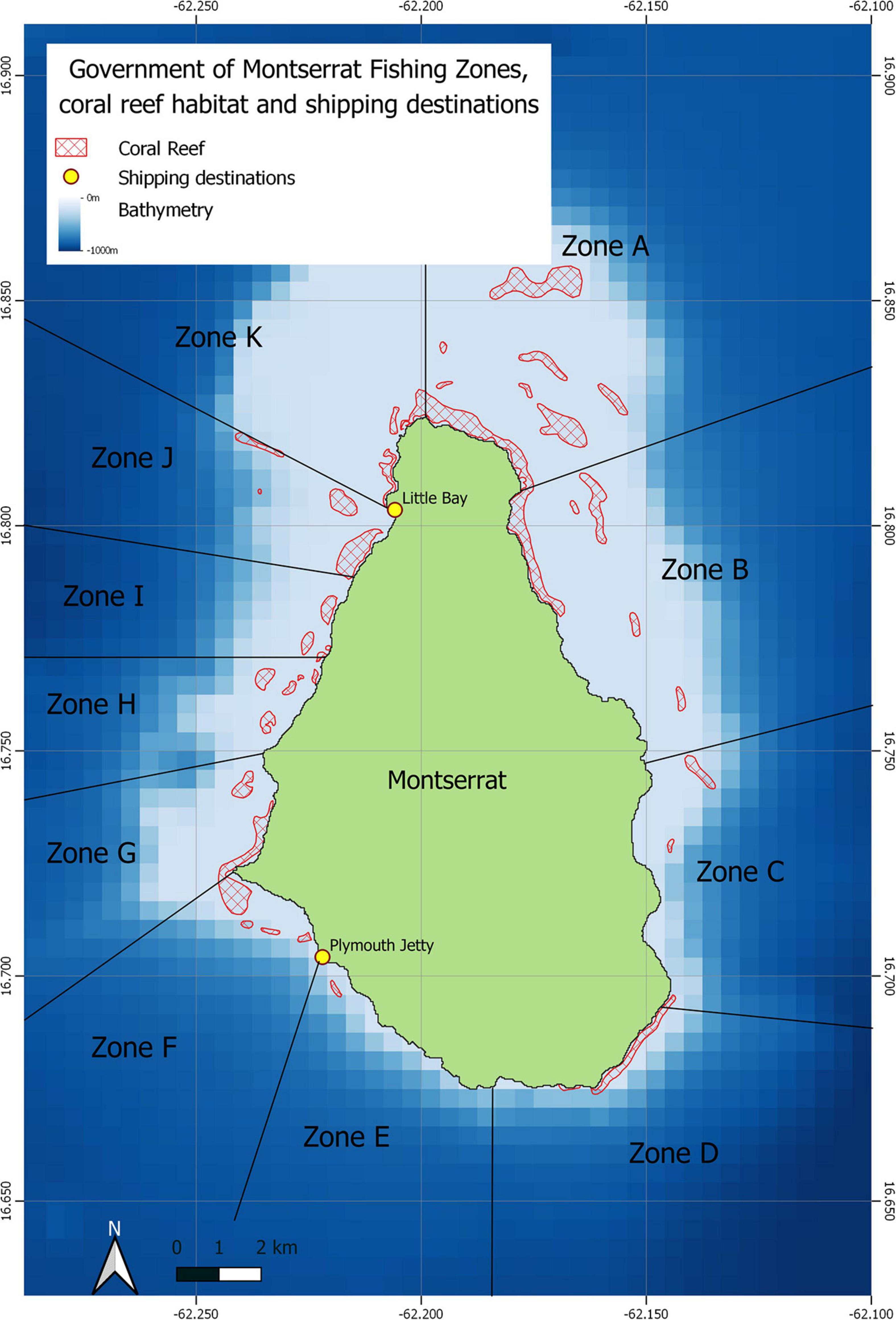
Figure 1. Government of Montserrat Fishing Zones and shallow-water coral reef habitats.
Querying the fisheries landings database for vessels operating within the area using predominantly fish pots as their main gear type, identified 12 vessels out of the fleet of 24, that had been recorded as using pots in Government of Montserrat Fishing Zone F, G, H, or I between 2018 and 2020. The data for three vessels were removed from the analysis in order to reduce the misidentification of other fishing activity types in the final outputs, as these vessels were known to predominantly fish with alternative gears or to be involved with alternative marine activities.
VTS Data Analysis and Mapping
Although participation in the vessel tracking programme in Montserrat is voluntary, the VTS covers 100% of the 24 vessels registered in the commercial fishing fleet on the island. Tracking began in April 2017, the VTS data analysed in this study are from March 2018 to May 2020.
The VTS provided by Pelagic Data Systems Inc. consists of a small solar-powered device installed externally on the vessel. This device records one Global Positioning System (GPS) position around every 30 s, along with vessel course and speed, this is between 600 and 3,600 higher resolution information than traditional vessel monitoring systems. It transmits these data in an encrypted data burst to the closest tower whenever in GSM (Global System for Mobile Communications) range. Data are uploaded to the Cloud and accessible through the Pelagic Data Systems dashboard. This device cannot be turned off and has a range of features to ensure that it is tamper proof. Location information is logged on the VTS directly from GPS satellites and stored on the device until it is within range to securely transfer the data. Unlike automatic identification systems (AIS), position data cannot be falsified.
The total quantity of extracted VTS data from the remaining nine vessels identified through the fisheries landings analysis was 4.3 million points. VTS data for the vessels identified as operating in the area of interest through fisheries landings data queries, were selected and downloaded from the Pelagic Data Systems cloud server through the online dashboard. Pre-processing by Pelagic Data Systems ensured that all downloaded data were complete and valid. These data were then analysed in bespoke code in R (R Core Team, 2019) to separate fishing activity from other vessel movements. A spatial filter was applied to remove all pings within 200 m of Little Bay, associated with non-fishing activity when the vessel is around it’s mooring and landing catches on the shore. The frequencies of recorded speeds in the data remaining were plotted in a histogram (Figure 2) to identify the peaks associated with fishing operations and vessel transit movements in order to identify speed thresholds that could be used to separate activity types (Lee et al., 2010). The histogram in Figure 2 shows the frequency of pings at different speeds for the nine vessels included in the analysis. This analysis shows no clear separation between potting and non-potting activity but shows a peak between 0 and 5 knots. Published methods to estimate the spatial distribution of pot-based fishing activity suggest a speed filter of 0.1–3 knots (Mullowney and Dawe, 2009; Lee et al., 2010). Local fishers suggested that the frequent speeds recorded between 2 and 5 knots were likely to represent alternative fishing activity (e.g., trolling on route to fishing grounds). Consultation with expert fishers(Ponteen, pers. comm.) suggested that vessel speeds between 0 and 2 knots would provide higher confidence in the threshold to capture the local style of pot fishing whereby single pots are manually deployed and retrieved whilst the engine is disengaged. As a result, expert opinion was used to refine the threshold of potting activity to 0–2 knots in the analysis to ensure that as few data as possible were included that represent transiting to or from fishing grounds. A simple speed filter was then applied to the remaining data to separate fishing activity from vessel transiting using the thresholds recommended by the local fishers, assuming any pings between 0 and 2 knots to represent pot fishing activity. Speeds exceeding this threshold were assumed to represent the vessel transiting to, from or between fishing grounds or other types of fishing activity as suggested by fishers. Processing resulted in a total of 698,466 points or 1,164 h of fishing operations, from 901 fishing trips on 453 days, from March 2018 to May 2020, represented in the final plots. A shapefile of the remaining data points was created from the R code and plotted in QGIS (QGIS.org, 2020) to create maps of pot fishing activity within the study area to distribute to the port authority and shipping representatives. The results of the final output were checked with experts from MALHE and expert fishers.
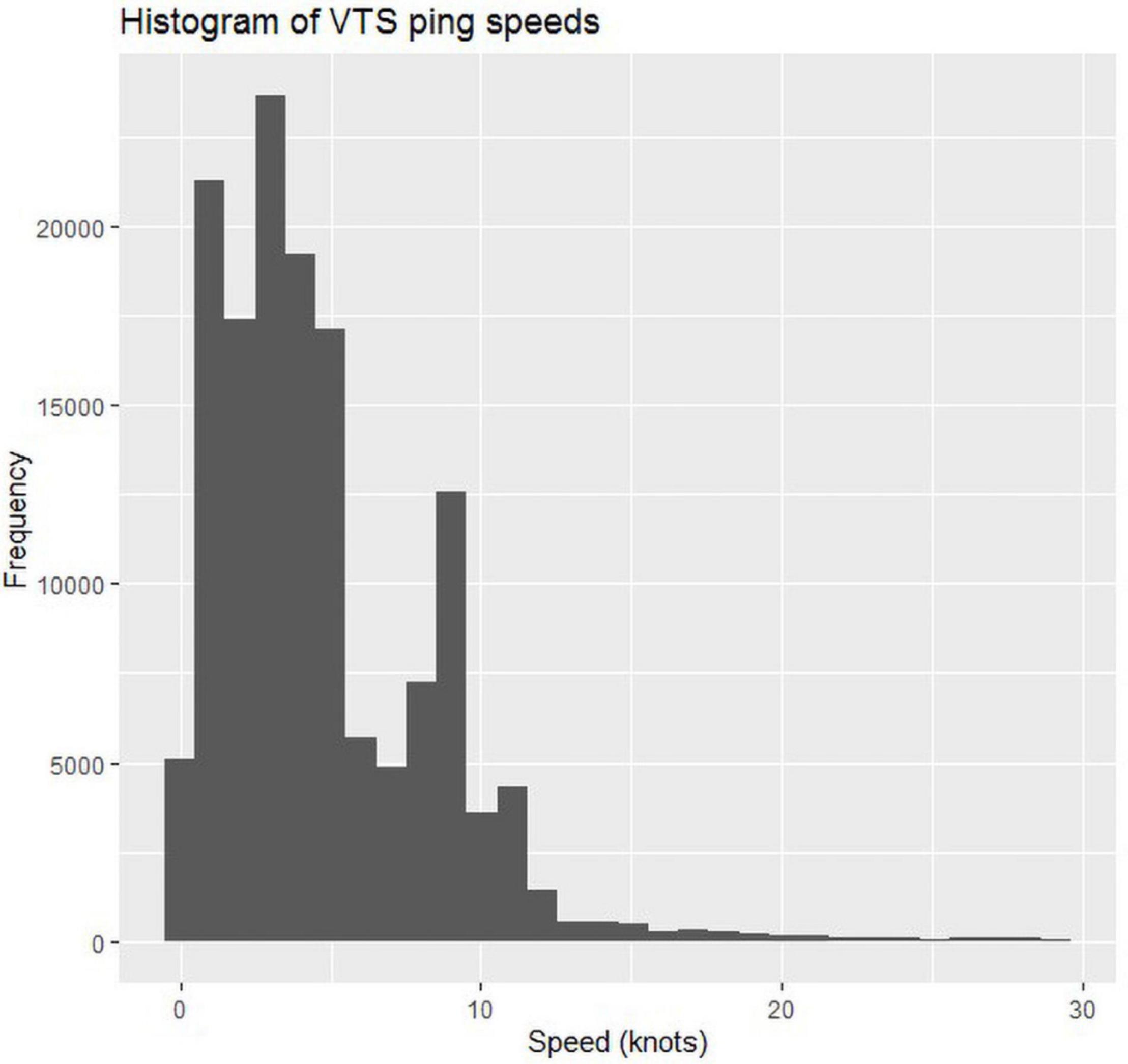
Figure 2. Histogram of VTS ping frequency from the 9 pot-based fishing vessels included in the analysis.
Mapping Shipping Activity
In order to understand the spatial footprint of commercial shipping activity in Montserrat’s waters, particularly in the conflict hotspot, 2018 and 2019 vessel density maps from Marine Traffic (MarineTraffic, 2020) were used. Marine Traffic uses data gathered from a network of coastal AIS receivers and satellite stations, integrated with additional data sources to visualise real-time vessel activity and routes.
Results
Stakeholder Engagement
During consultation with marine users, coral reef areas were highlighted as hotspots of marine activities and potential impacts, due to significant interest from stakeholders. A range of activities and potential pressures, including spatial conflicts between marine users were highlighted. Examples of which included the competition for space on reefs between fishers (particularly those using seine nets) and dive operators and vessel-gear interactions between fish pots and commercial shipping vessels. Other pressures such as anchoring on reefs, vessel groundings, physical damage from fishing activities and divers, and litter were also identified by stakeholders. These activities were plotted through participatory mapping exercises on maps of the island and surrounding marine environment (Supplementary Figure 1 and Supplementary Table 1).
Table 1 summarises the stakeholder prioritisation discussions based on the activities and pressures identified. Based on these discussions, stakeholders agreed that the current activity with the greatest potential environmental and economic impacts, with no intervention currently in place, was the vessel-gear interactions between Montserrat’s pot fishery and aggregate shipping vessels along the western coast. If vessels pass too close to the fish pots, gear may become entangled with vessels, leading to damaged or lost fish pots. A perceived increase in damaged and lost gear, due to the shipping operations, led to an increase of complaints from users to the Government of Montserrat about vessel-gear interactions, resulting in the need for conflict resolution. Although not quantifiable, as complaints were not systematically recorded, the magnitude of the problem and impacts on the fishing community had garnered political interest and resulted in fishers contacting ministers for support.
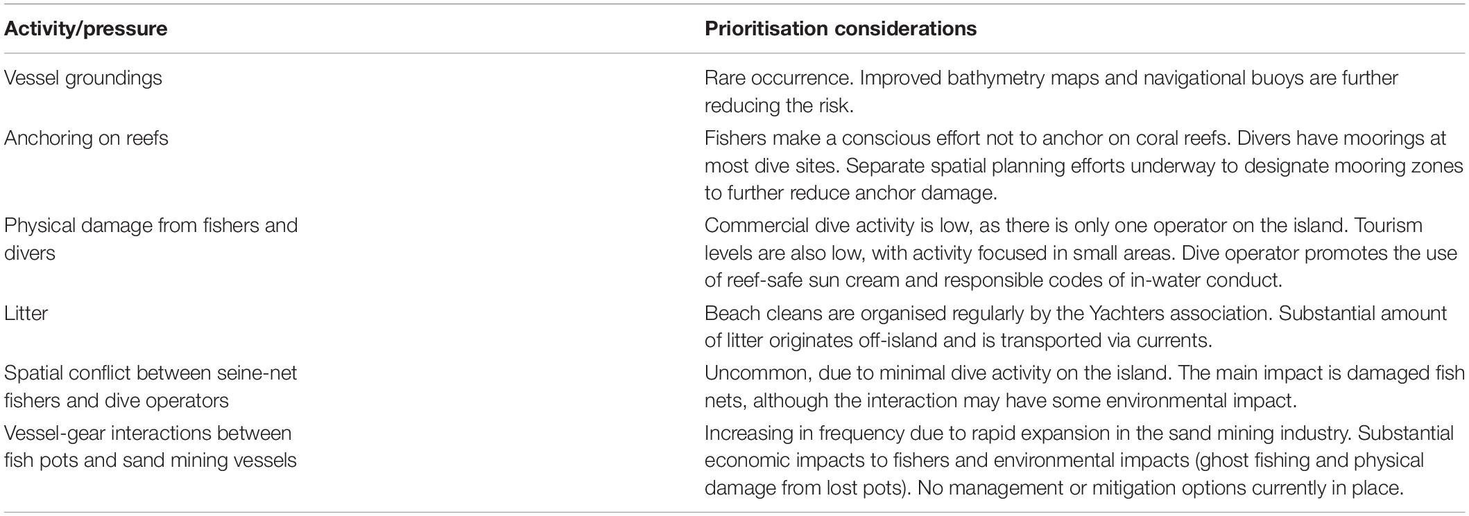
Table 1. Outcomes from stakeholder activities and pressures prioritisation discussions.
Following feedback from stakeholder consultations, the Government of Montserrat’s decision to prioritise this conflict for intervention was made based upon a combination of strong stakeholder buy-in and a view that this was the most pressing activity causing both economic and environmental damage. This was compounded by institutional support for the fishing community and the recognised value of the contribution of the fisheries sector, both economically and culturally.
Stakeholder mapping concluded that the main ecosystem goods and services, and associated stakeholders concerned in this conflict were: the provision of food and income for fishers, predominantly reef fish captured in fish pots; transport of goods for commercial shippers, particularly the sand mining industry, and transit through the area for access to shallower reefs and coastline for divers and recreational vessels. Other stakeholders identified that may be impacted by management intervention were fishers using other gear types (trolling, seine nets), the Montserrat Port Authority and the Montserrat MALHE. It was noted that further consideration should also be given to leisure vessels and dive operators, as they may also be contributing the vessel-gear interactions.
During consultation, fishers emphasised the scale and frequency of the problem and its impacts upon their livelihoods. Through mapping exercises, a key hotspot for gear losses was identified off the south-west of the island on the northern approaches to Plymouth jetty, specifically in Montserrat fisheries zones F, G, H, and I (Figure 1). It was noted that interactions in this hotspot had increased significantly in the past year as a result of changes in sand mining locations and vessel routes. Of the various mitigation options considered, it was evident from participant feedback and the alternative routes drawn on the maps by fishers, that the consensus was that the most effective option to minimise interactions would be to re-route commercial vessels further offshore, away from the fishing grounds in question.
Prior to this conclusion, other options for mitigation were considered, including compensating fishers for loss of fishing grounds and the improved marking of pots. It was deemed financially unfeasible to provide financial compensation to fishers that may lose their fishing grounds within the study area with the nature of funding available, as the area in question is one of the most commonly used areas by fishers using fish pots, which is the most commonplace gear type in Montserrat (Sustainable Fisheries Group, 2016; Ponteen, 2018). Similarly, the options for alternative fishing grounds were limited, due to weather conditions on the eastern side of the island, and loss of previous fishing grounds and reefs through volcanic activity and smothering. In addition, maritime exclusion zones are still in place around the south-western and south-eastern coastal waters of the island, rendering these areas periodically inaccessible to fishers. Moreover, the legislative instruments to enforce such options are not currently in place in Montserrat. It was suggested in consultation that fishers may continue to fish within the study area regardless of management intervention, even when faced with the current threat of gear-loss, due to the high value of the fishing grounds. However, any management to reduce interactions would be beneficial to both fishers and the marine environment.
Consultations highlighted that the current method of marking the fish pots with buoys is inadequate and likely to be contributing to the vessel-gear interactions. It was agreed that investing in improved buoys to mark the fish pots should be considered in the near future as an addition to re-directing the vessels, as this will reduce the likelihood of interactions between gear and smaller leisure craft. However, this method was deemed insufficient by stakeholders to mitigate the current interactions between gear and sand mining vessels, due to the density in which fish pots are placed within the study area, making them difficult for larger vessels to avoid. In addition, due to the size and speed of commercial shipping vessels, it can be challenging for captains to see these markers in certain sea conditions, regardless of how diligent they may be, this was echoed by the captain of the Montserrat Ferry (Gooding, pers. comm.). Similarly, the size of buoys required to successfully mark the pots through all weather conditions, given the depth of water that they are situated in, is substantial. This presents certain logistical challenges with deployment due to the small size of fishers’ vessels used to deploy the pots and marker buoys (typically between 3 and 10 m).
It was also proposed that the edges of the reef fishing grounds were marked with hazard buoys to ensure that all sea-users are aware of the presence of fish pots in that area, particularly those unfamiliar with the island. Concerns were raised by other fishers that any hazard marker buoys could potentially interfere with other fishing operations (the beach seine net fishery) if positioned inappropriately.
The pot fishery in Montserrat is thought to be near capacity (Sustainable Fisheries Group, 2016), however, retiring fishers and investigating alternative livelihoods was not considered as a potential method of mitigation within this study. Montserrat’s fishing fleet is small, and the current level of fish production is not enough to satisfy local demand (Ponteen, 2013). As Montserrat’s strategic policy goals include reducing the reliance upon imports and increasing food security and the consumption of local food (CARICAD, 2016), it was deemed unviable to retire fishers and would not have been politically supported. However, long-term consideration is being given to encouraging new fishing methods and diversification to reduce the pressure on the pot fishery. The Government of Montserrat are looking to diversify the fisheries sector through the expansion of fish aggregation device (FAD) fisheries, targeting pelagic and coastal-pelagic species. This shift will divert pressure away from this multiple-use area to the planned locations of FADs, which will also reduce the number of individuals using fish pots, in favor of trolling. However, to ensure that the expansion is as sustainable as possible, the Government of Montserrat are currently conducting further research into the capacity to expand the fisheries without over-exploitation (Townhill et al., 2019). This is a long-term aspiration for Montserrat, which will not bring immediate resolution to this conflict, however, this may provide a longer-term solution to spatial conflicts in this high-demand area.
During discussions with commercial shipping operators, through the Montserrat Port Authority, operators raised concerns around a shipping route that requires vessels to travel significantly offshore, as this will increase fuel costs and require vessels to travel where sea conditions are more frequently unfavourable. Shipping representatives highlighted that the buoys used by fishers to mark the fish pots are typically homemade, usually consisting of plastic bottles or plastic floats, and have poor visibility to passing traffic in daytime, and none during darkness. The small size and limited buoyancy of the buoys means that they are subject to being submerged in certain sea conditions, further reducing the visibility. As a result, passing vessel traffic is often unaware of the presence of deployed fishing gear in the area. In addition, excess rope deployed to connect the pot and buoy can result in a higher risk of entanglement due to the increased radial movement of the buoy around the pot and resulting greater quantity of rope in the upper water column. Subsequently, this has made passing through the western fishing grounds, while avoiding fishing gear, particularly challenging for shipping vessels. Recognising both the impacts of the issue on fishers’ livelihoods and the potential costs incurred to shipping by rerouting to avoid an area of fishing ground, the Montserrat Port Authority required additional evidence of the exact location of the fishery in order to underpin any proposed management intervention involving re-routing of marine traffic.
It was understood that the area in which the conflicts were described was of little direct interest to the recreational diving sectors due to the depths of water involved. The role of passing leisure traffic was also considered as a potential cause of vessel-gear interactions. However, stakeholders recongised that leisure traffic typically desired to be close to the shoreline for aesthetic reasons and it is unlikely that these vessels spend substantial time transiting through the fishing grounds, thus it was suggested that it would be unnecessary to seek to re-route leisure vessels and remove that amenity. As levels of tourism and leisure traffic have decreased significantly due to volcanic activity, and leisure activity tends to occur during periods of daylight and calmer ocean conditions, it was felt that raising awareness of the presence of fish pots through hazard buoys in the area would sufficiently minimise potential interactions.
Spatial Distribution and Intensity of Fishing Effort
The raw data (Figure 3A) show the spatial distribution of the activity of a subset of nine fishing vessels which were recorded as operating mainly with pots within the areas of interest highlighted as a gear conflict hotspot in between 2018 and 2020. Within the study area, pot fishing activity is widespread along the west coast, from close inshore out to depths of around 100 m, targeting discrete areas. The map of pot fishing activity intensity (Figure 3B) shows that the greatest activity is distributed along the edge of the 100 m contour, before steep gradients into deep water beyond the operational depth limits of the pot fishery. The highest activity is toward the south of the study area in the approaches to Plymouth from the north and west. This corresponds to the area highlighted by fishers as a hotspot for gear losses during stakeholder discussions. There is also considerable potting activity in the inshore which corresponds to known mapped coral reef areas in shallower water (Figures 1, 3).
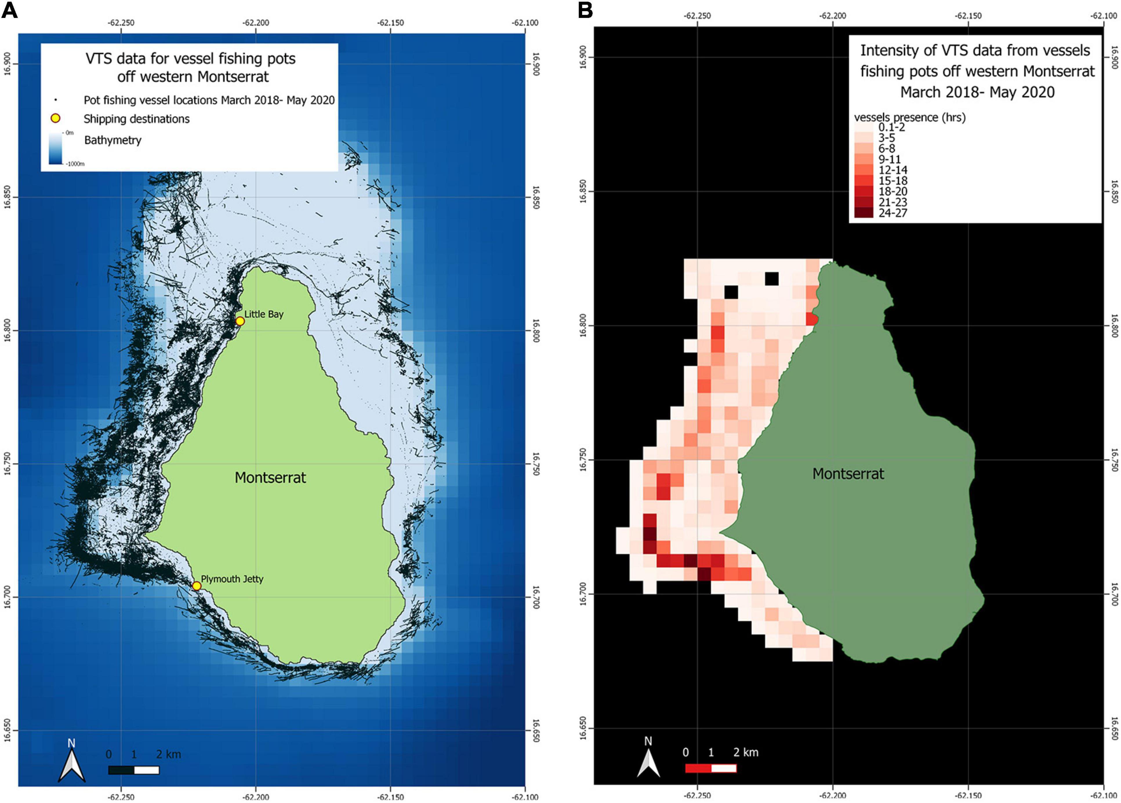
Figure 3. (A) Raw point data of pot fishing vessel activity off western Montserrat. (B) Intensity map of pot fishing vessel activity off western Montserrat.
Analysed data and maps were presented to the Montserrat Port Authority and reviewed to identify the extent and boundaries of fish-pot activity in the area. This spatial information, alongside bathymetry data, allowed the Port Authority to identify an area to restrict commercial vessel activity to avoid fish pots and to find a suitable route for vessels around the area whist minimising additional travel.
Spatial Distribution and Density of Commercial Shipping
Figure 4 shows the spatial distribution and density of all shipping activity in Montserrat in 2018 (4a) and 2019 (4b) as recorded through AIS and displayed through MarineTraffic. 4c and 4d show the spatial distribution and density of specifically tugs and special craft in 2018 (c) and 2019 (d). All figures display evidence of the shipping activity reported along the south-western coast, through the fishing grounds. These data also confirm consultation findings that the intensity of shipping activity within the fishing grounds has increased between 2018 and 2019 as a result of changes in sand mining locations and the overall rapid expansion of the sector. 3d specifically shows an increase in 2019 in the density of tugs and special craft in the fishing grounds in question, in the waters around the most western point of the island.
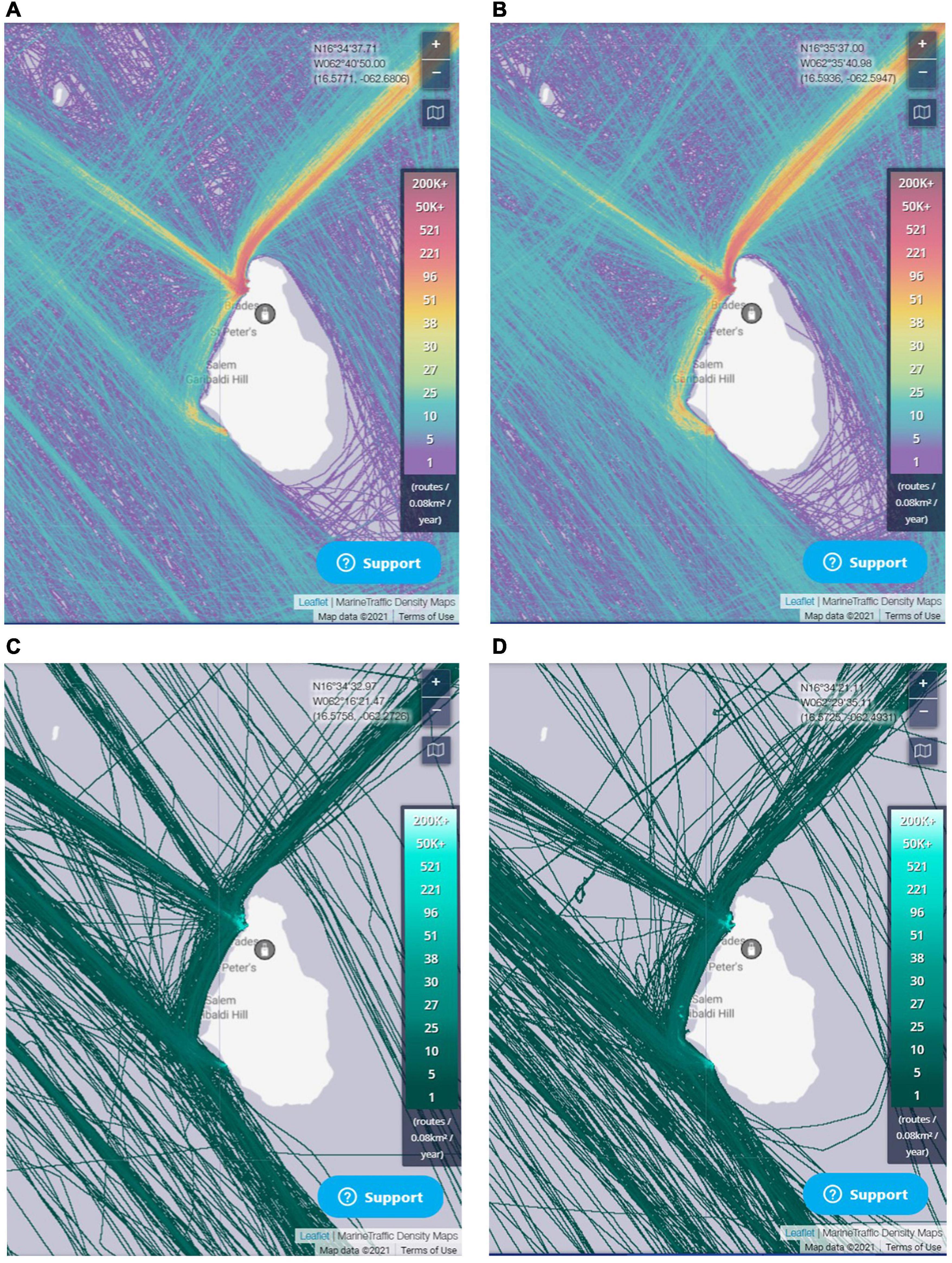
Figure 4. Vessel density data from MarineTraffic.com. (A) Density of all vessels in 2018. (B) Density of all vessels 2019. (C) Density of tugs and special craft in 2018. (D) Density of tugs and special craft in 2019.
Outcomes
In response to stakeholder proposals and the analysed data, the Montserrat Port Authority proposed a restricted area extending along the west coast of the island. This proposal balanced the requirements of both sets of stakeholders involved in the conflict by re-routing vessels far enough offshore to avoid fish pots, while using spatial data from the pot fishery to remain as inshore as possible to avoid excess fuel costs and unfavourable weather conditions for commercial shipping vessels. The restricted transit area commences from just north of Plymouth jetty moving offshore to around 3 km west of Bransbury Point, progressing northwards and re-joining the shoreline beneath Government Headquarters in Brades (Figure 5). Within this area, commercial vessels (cargo vessels, tugs, and barges) are not allowed to transit.
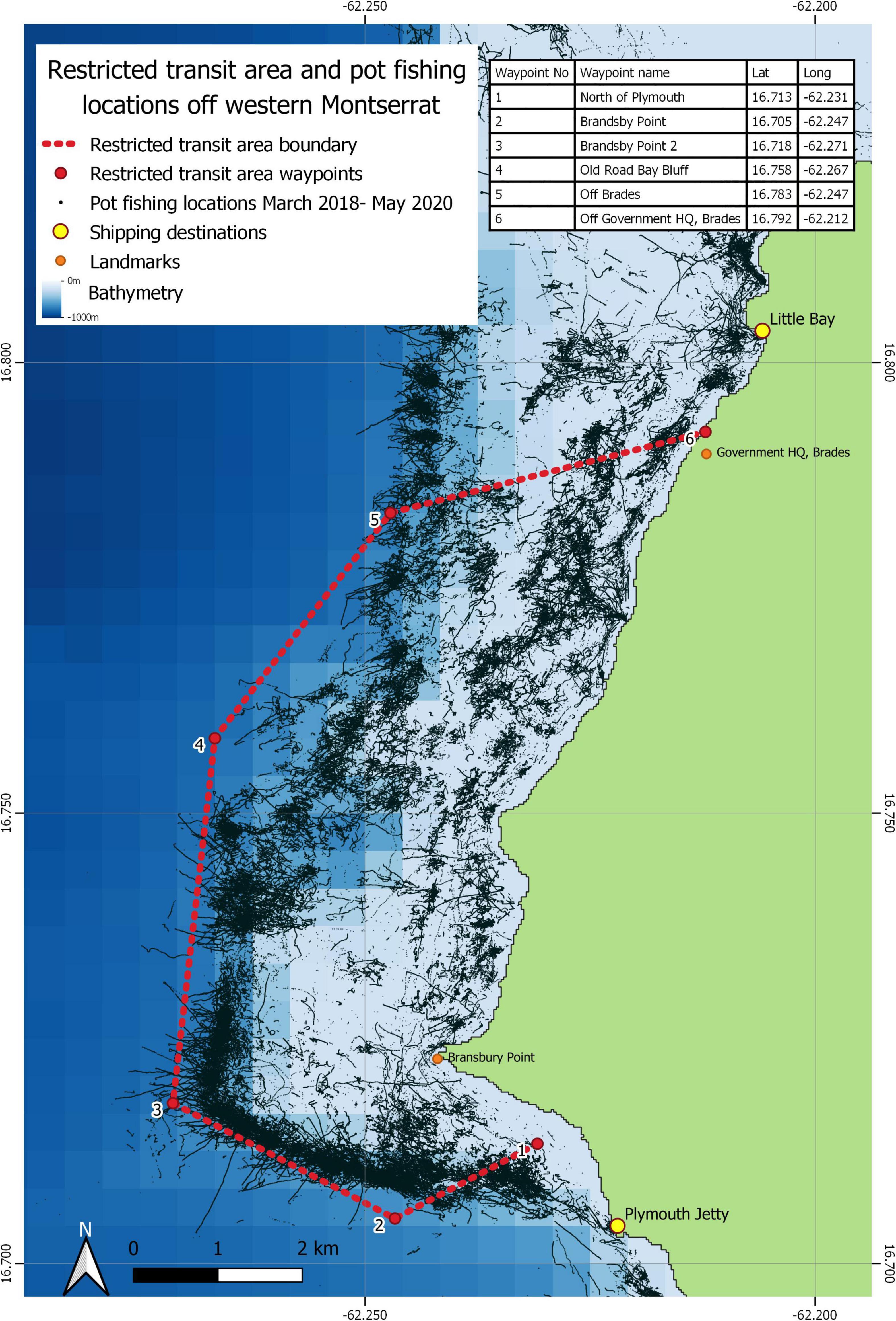
Figure 5. Restricted transit area and locations of pot fishing in south west Montserrat.
Implementation of this restricted area means that commercial vessels leaving the port at Little Bay need to travel at least 3 km offshore to pass waypoint 5 (Figure 5) and must continue almost 3.5 km offshore heading south-west past waypoint 4. The boundary line between waypoints 2 and 3 protects the most intensive area of fishing activity on the edge of the reef to the north. After passing waypoint 2, the vessels can make a more direct approach to Plymouth jetty. Vessels departing Plymouth jetty for a destination in any northerly direction will need to travel at least 3 km away from the shore to waypoint 3 before heading northwards. Vessels approaching Plymouth jetty from the south or due west will not be affected by this restricted area. Leisure and recreational vessels, such as pleasure crafts, are exempt from this restricted area, and it is unlikely that this intervention will have significant effects on these sectors. It is possible that the restricted area diverting larger vessels offshore when transiting, will be beneficial to both leisure vessels and dive operators by reducing vessel traffic around the coastline, where their activities are concentrated. There is currently no mobile benthic fishing occurring in Montserrat’s waters and other typical fishing methods, including spearfishing, trolling and seine nets, occur closer to shore, in waters shallower than 100 m deep, as such it is unlikely that the restricted area will significantly impact these fishing activities.
Discussion
In the Caribbean, there are few examples of how science can contribute to the spatial planning process in practice, and many small islands may lack suitable data to support spatial planning (Pomeroy et al., 2014). In order to improve marine spatial planning efforts in the Caribbean, a diverse set of information needs to be integrated. Doing so in “data poor” situations requires application of innovative tools with a strong focus on participatory approaches (Pomeroy et al., 2014). Here we show how combining a stakeholder-led consultation approach with supporting analytical evidence can identify suitable solutions to complex spatial planning conflicts that meet the requirements of all parties involved. The use of innovative, cost-effective, small scale vessel tracking devices has enabled spatial data collection from previously unmonitored vessels. The analysis of fisheries landings and VTS data, alongside outcomes from stakeholder consultation, allowed managers to develop an impartial, data-led solution with the identification of a restricted transit area, suitable for all key stakeholders. The data on the spatial scale of the pot based fishery allowed the management intervention to balance the requirements of the fishing community to remove commercial shipping traffic from these fishing grounds, while keeping excess travel time, fuel costs, and potential poor weather conditions to a minimum, as per the requests of the shipping industry. A lack of formal baseline of conflict scale or frequency, beyond stakeholder complaints, which were not systematically recorded, makes quantifying the success of this management intervention challenging. However, opportunities do exist to monitor future complaints and to undertake surveys of fisheries to understand if the loss of pots and ongoing conflict with shipping declines. AIS data can also be monitored to understand how commercial shipping activity changes as a result of intervention.
The boundary coordinates of the restricted area have been distributed amongst local operators. MALHE will regularly review the VTS data outputs with the Montserrat Port Authority to ensure that the restricted area remains appropriate and efficient and can be adapted to reflect changes in fisher effort or distribution. If the Government of Montserrat decide to expand the current FAD fishery and install additional offshore FADs, dependant on the chosen locations, the restricted area may require adaptation to avoid interactions between FAD-based fishing and commercial shipping activity.
Benefits of Fisher Participation
Recent years have seen increased recognition of the benefits of engaging the fishing community in marine management activities, through data collection, enforcement, advocacy, and research (Granek et al., 2008; Almany et al., 2010; Ernst et al., 2010). This can benefit managers and researchers through both increased capacity for monitoring and management activities (Granek et al., 2008) and additional information from undocumented local knowledge from fishers (Gaspare et al., 2015; Berkström et al., 2019). In turn, this engagement allows fishers to input into the management that will directly affect them and the environment that supports them. Participation in Montserrat’s VTS data collection has always been voluntary; however, the programme has achieved 100% participation from fishing vessel owners. Often fisheries data has been used most visibly as part of management regulations and restrictions, and fishers may view scientists with suspicion with concerns that data may be “used against them” (Wilson, 2003). Achieving 100% participation in VTS data collection is the result of extensive engagement and trust building efforts with Montserrat’s fishing community. This has enabled the collection of accurate spatial data on fishing activities, which is often lacking and challenging to obtain to inform management and marine spatial planning efforts (Baldwin and Mahon, 2014; Pomeroy et al., 2014). In turn, these data have been used to fishers’ benefit, to enable fair and evidence-based intervention to reduce vessel-gear interactions. This project has developed and strengthened stakeholder engagement processes and demonstrates tangible positive results of participating in data collection directly to fishers. In turn, this will help to stimulate fishers’ participation in VTS and other fisheries data collection efforts into the future. Participation in data collection can simultaneously engage, empower, and build capacity for stewardship (Pomeroy et al., 2014). In addition, this can enable fishers to engage in an open dialogue with managers, fosters a shared perception of conservation challenges and opens discussion of management alternatives (Chuenpagdee et al., 2004). Encouraging fisher participation in assessment and management, through the use of fisher’ knowledge is encouraged as best practice in improved fisheries governance (Stephenson et al., 2016).
Limitations of the Data
Vessel tracking systems data from all vessels recording predominantly pot fishing activity in the relevant Government of Montserrat fishing zones were included in the analysis. As a result, the outputs include data for an unquantified number of fishing trips where pots may not have been used. A more refined approach would link the VTS data to specific landings data from each fishing trip, including only specific fishing trips for which pot fishing activity was recorded. Furthermore, the data also include fishing activity during which pots were only used for a part of the fishing trip. Whilst the Government of Montserrat’s landings interview process seeks to gather start and end times for the use of specific gear time, these data were not consistently recorded and could not be used in this analysis. In addition, it is possible that vessels that infrequently use fish pots may have been excluded from the analysis. The use of expert opinion from both fishers and the Chief Fisheries Officer to identify vessels may not be as applicable in larger settings. However, due to the size of Montserrat’s fishing fleet and in-depth knowledge of the sector from both fishers and fisheries unit employees, this method, partnered with fisheries landings data, can be used with a certain degree of accuracy in this setting to identify vessels that predominantly use fish pots.
Due to the time constraints for providing supporting evidence to decision makers, a simple speed filtering approach was applied to the VTS data to identify fishing activity. It is unlikely that any speed rule will identify the activities of vessels without error, as there will be occasions where a vessel may transit at the slow speeds that have been associated with fishing activity, for example, when experiencing bad weather. Static fishing gear presents additional challenges because the realised fishing effort depends on the size, type, and soak time of nets or traps, and VMS data provide insight into the vessels’ area of operation rather than fishing effort (Lee et al., 2010). A more refined approach using the spatial dynamics of the vessel’s track (changes in heading and speed) could improve the separation of fishing activity and vessel transiting (Mendo et al., 2019) and might allow the discrimination of different fishing activity types with different gears within a single fishing trip. However, the outputs generated here using only data from vessels predominantly using pots and a simple vessel speed filter provided a representation of the footprint and intensity of the fishery which was adequate for the purpose of marine spatial planning and informing a specific management intervention.
Further work will integrate the FISHCANA fisheries database with the Pelagic Data Systems VTS online dashboard. This would make fisheries spatial and linked landings data accessible as they are collected, enabling the Government of Montserrat to easily apply similar methods to those described here quickly and independently, allowing a more rapid, evidence-based response to emerging issues. Fishers can also benefit from being able to access their own data which may help them to optimise their future operations.
Additional Management Recommendations
Not all areas of pot fishing interest are encompassed within the restricted transit area. Areas of high activity to the north of the restricted area, in particular within the heavily-used approaches to Little Bay, present a continued risk of entanglement with passing vessel traffic. The development of appropriate guidance for the fishing operators of Montserrat on the marking of fishing gear, in line with FAO voluntary guidance (Food and Agriculture Organisation (FAO), 2019), may further reduce gear losses and aid in the identification and recovery of gear. This could see improvements in the materials used for pot marker buoys to increase visibility and improved rigging of gear appropriate to the depths of water in which it is deployed. Such changes would complement the management measures and would be expected to further reduce the risk of gear damage or losses to any passing vessel traffic. However, specific guidance for Montserrat must consider the logistical constraints of deploying substantial marking systems from the small vessels used by the fishing fleet. Similarly, installing escape panels in fish pots can reduce the ghost-fishing impact of lost gear on marine species (Pecci et al., 1978; Bilkovic et al., 2012; Broadhurst and Millar, 2018).
To alert unfamiliar vessel traffic to the location of the restricted area, work is underway to install hazard marker buoys within the boundary of the restricted area. These buoys stand over 1.5 m high above the sea surface with a visible area of 1.1 m2, and are topped with internationally recognised St Andrews cross hazard marker. This will provide much greater visibility to passing vessel traffic than the buoys marking the individual pots and can be expected to raise awareness of the restricted access and the potential hazard of fishing gear in the area. The hazard marker buoys will not show the exact locations of pots, and as such are unlikely to allow vessels to successfully navigate between the pots within the area, however, they will alert captains to the presence of fishing gear in the vicinity to encourage vigilance or avoidance of the area, for the smaller vessels that are permitted within the restricted zone.
In the United Kingdom, spatial fisheries management to resolve conflict and competition for space between different types of fishing gears (towed mobile gears versus static gears) has resulted in an increase in the amount of static gear fishing effort in protected areas. Once the competing pressure was removed and the risk of gear loss reduced, localised increases in static gear activity were reported in Lyme Bay and Windsock protected areas (Jaworski and Penny, 2009; Mangi et al., 2011). The pot fishery on Montserrat is already believed to be near capacity (Sustainable Fisheries Group, 2016) and the impacts of this management intervention on overall pot fishing effort should be monitored closely and potential further management options considered if effort increases.
The current COVID-19 pandemic has highlighted the potential vulnerabilities of small-island states; this has emphasised the need for Montserrat to reduce reliance on external import for food and on the tourism industry for jobs and income (Ponteen, pers. comm.). As the island begins to seek opportunities to increase domestic food production, reduce the reliance on imports, and to increase commercial exports such as sand and aggregate, there is the potential for other conflict hotspots to arise in the marine environment around the island. As such, a similar exercise to this study may be necessary in the future, to minimise additional vessel-gear interactions elsewhere around the island where conflict may occur.
Under the Fisheries Act 2013, there is a statutory requirement for the Government of Montserrat to produce a Fisheries Management Plan, however, this is yet to be completed (Brewin et al., 2018). The development of a fisheries management plan provides an opportunity to further utilise the participatory framework that has been established in Montserrat. Fishers have previously expressed an interest in receiving more feedback from the Government of Montserrat on their efforts to support data collection and sustainable fishing (Brewin et al., 2018) and this is something that should be incorporated into future processes to develop management.
Dissemination of information and developments is currently conducted through a strong word-of-mouth process. Montserrat’s Chief Fisheries Officer stays in regular contact with the fishers through the Fishers and Boaters Association (Brewin et al., 2018). However, this open dialogue could be further facilitated using regular update meetings, informal workshops, and knowledge exchange exercises. Future marine spatial planning efforts should endeavour to maintain inclusive participative processes with all stakeholders and utilise robust supporting evidence when developing further management. Efforts are also underway to encourage fishers to access to their own VTS data online to improve transparency and further foster collaboration.
Regional Application
A range of complex issues face Montserrat’s marine environment, including sedimentation, freshwater runoff and ocean acidification as a result of the Soufriere Hills Volcano, compounded by the impacts of climate change. The island is in a unique situation: recovering both environmentally and economically from a variety of natural disasters, where space is at a premium. Although this complex picture may be unique to the environment of Montserrat, the island presents a good example of successful engagement with the fishing community that may be applicable to neighbouring islands in the region. Similarly, the use of technology to build the fisheries evidence-base has transformed the understanding of fisheries on the island and such an approach may benefit other countries with sustainable fisheries management and reporting. Montserrat is nonetheless small, with a population of approximately 5,000, which has aided engagement and relationship building. Such engagement may prove more challenging and take longer to achieve in larger settings. Similarly, the introduction of technology to aid data collection is likely to be more costly in larger fisheries sectors and require more sophisticated solutions. These are the early stages of marine management, that have set the foundation to enable Montserrat to establish community-based management frameworks, to ensure the sustainability and long-term conservation of its marine environment.
Conclusion
This management intervention is the result of an ongoing process to better understand Montserrat’s marine environment and the associated dependent activities, through the development of a quantitative evidence base. Traditionally, fisheries have felt side-lined in favour of more visible industries with a more easily quantifiable contribution to the economy of Montserrat (fisher, pers. comm.). Additionally, small, artisanal fisheries are historically hard to assess and are often subject to data-poor decision making. However, here we demonstrate the potential for success by bridging the gap between fishers and managers, building trust, engaging the fishing community in data collection and empowering fishers to take ownership of the collection of accurate data. These data can then support evidence-based and impartial decision-making that ensures the sustainability of both livelihoods and the natural environment that they rely upon. The fisheries sector in Montserrat is one of the smallest in the Caribbean, contributing less than 0.5% to Montserrat’s GDP (Ponteen, 2013), in contrast to the aggregate industry, which is currently Montserrat’s primary export and a key industry in national policy, including the Government of Montserrat’s Sustainable Development Plan 2008–2020. This intervention has demonstrated to fishers the benefits of engaging with managers and data collection, which has in turn supported the equal consideration of the interests of two sectors with considerable differences in economic contribution and influence. This has set the foundation for further engagement and the inclusion of stakeholders in future management planning processes.
Fisheries data collection is ongoing; this evidence base will play an important role in the sustainable development of fisheries, marine spatial planning legislation and adaptive management, improving assessments of the status of fish stocks and fishing efforts, contributing to vital ecosystem protection. As the island explores opportunities to increase domestic food production, and to ensure vital marine ecosystems are protected, these plans and management measures will be essential to ensure a sustainable post COVID-19 recovery, and to secure Montserrat’s future.
Data Availability Statement
The data analysed in this study is subject to the following licenses/restrictions: The datasets analysed for this study cannot be made publicly available due to the sensitivities around vessel tracking and fisheries data. A condition of voluntary participation in Montserrat’s data collection programme is that fishers own the data collected and must be consulted on any use of these data. The authors have permission to display the processed outputs of the data in this manuscript, however, the raw data cannot be made available. Requests to access these datasets should be directed to AD,QWJiaWUuRG9zZWxsQGpuY2MuZ292LnVr.
Ethics Statement
Ethical review and approval was not required for the study on human participants in accordance with the local legislation and institutional requirements. Written informed consent for participation was not required for this study in accordance with the national legislation and the institutional requirements.
Author Contributions
AD, DE, LC, and JH delineated the study, collected the data, and wrote the manuscript. DE, AD, and JH assessed the consultation outcomes. DE analysed the fisheries and VTS data. AG led previous fisheries work in Montserrat and worked on the manuscript. JH, LC, JO’G, and AP contributed with resources. JO’G and AP provided fisheries and navigation data and expertise on-island. All authors contributed to the article and approved the submitted version.
Funding
This work was financially supported by the United Kingdom Government through Official Development Assistance (ODA) and the Conflict, Stability and Security Fund (CSSF).
Conflict of Interest
JO’G was employed by the Montserrat Port Authority.
The remaining authors declare that the research was conducted in the absence of any commercial or financial relationships that could be construed as a potential conflict of interest.
Acknowledgments
We would like to thank O’Garro, Lavern Rogers-Ryan at MALHE for the overall project support and coordination on island and assistance with consultations; Lyandra Lee, Javier Adams, and Chase Lee at the MALHE Fisheries Unit for the collection of fisheries data; Dillon Weekes and George Green at Montserrat Port Authority and Damian Jauss for maritime expertise; Montserrat Fishers and Boaters Association and all of the Montserrat fishing community for their ongoing participation and expertise; Tony Weighell for the oversight of JNCC’s previous work in Montserrat; and Christine Maggs and Bryony Meakins whose comments helped to significantly improve the manuscript.
Supplementary Material
The Supplementary Material for this article can be found online at: https://www.frontiersin.org/articles/10.3389/fmars.2021.635890/full#supplementary-material
References
Al-Masroori, H., Al-Oufi, H., Mcllwain, J. L., and McLean, E. (2004). Catches of lost fish traps (ghost fishing) from fishing grounds near Muscat, Sultanate of Oman. Fish. Res. 69, 407–414. doi: 10.1016/j.fishres.2004.05.014
Almany, G. R., Hamilton, R. J., Williamson, D. H., Evans, R., Jones, G. P., Matawai, M., et al. (2010). Research partnerships with local communities: two case studies from Papua New Guinea and Australia. Coral Reefs 29, 567–576. doi: 10.1007/s00338-010-0624-3
Baldwin, K., and Mahon, R. (2014). A geospatial framework to support marine spatial planning and management for the transboundary Grenadine Islands. Electron. J. Inform. Syst. Dev. Ctries. 63, 1–18.
Berkström, C., Popadopolous, M., Jiddawi, N. S., and Nordlund, L. M. (2019). Fishers’ local ecological knowledge (LEK) on connectivity and seascape management. Front. Mar. Sci. 6:130. doi: 10.3389/fmars.2019.00130
Bilkovic, D. M., Havens, K. J., Stanhope, D. M., and Angstadt, K. T. (2012). Use of fully biodegradable panels to reduce derelict pot threats to marine fauna. Conserv. Biol. 26, 957–966. doi: 10.1111/j.1523-1739.2012.01939.x
Brewin, P., Brickle, P., Gregory, A., Pelembe, T., Edwards, D., and Weighell, T. (2018). Fisheries Data Collection and Integration Strategy for Underpinning Sustainable Fisheries Management in Montserrat. Draft Report. Available online at: https://data.jncc.gov.uk/data/879ac41b-63a0-4981-afce-9d1e47b4da7d/ot-nca-sup-cbn-07-mst-data-int-strategy-draft.pdf (accessed April 02, 2021).
Broadhurst, M. K., and Millar, R. B. (2018). Relative ghost fishing of portunid traps with and without escape gaps. Fish. Res. 208, 202–209. doi: 10.1016/j.fishres.2018.07.0182018.07.018
CANARI (2011). Facilitating Participatory Natural Resource Management: A Toolkit for Caribbean Managers. Available online at: https://www.iwlearn.net/documents/28814 (accessed April 02, 2021).
CARICAD (2016). Agricultural Strategy and Marketing Plan (ASMP) 2016−2021. Prepared for the Government of Montserrat. Brades, Montserrat. 71.
CEMARE (2002). The Management of Conflict in Small-Scale Fisheries. Portsmouth: University of Portsmouth, 61.
Chuenpagdee, R., Fraga, J., and Euán-Avila, J. I. (2004). Progressing towards co-management through participatory research. Soc. Nat. Resour. Int. J. 17, 147–161.
Edwards, D., Doyle, A., Brickle, P., and Brewin, P. (2017). T2T Montserrat Fisheries Data Workshop Report. Peterborough: JNCC.
Eftec (2019). A National Ecosystem Assessment of the UK Overseas Territory of Montserrat: Natural Capital Assessments, Mapping and Monitoring Methods – Phase II Contract Number: C17-0304-1159 Final Report For the Joint Nature Conservation Committee. Peterborough: JNCC.
Ehler, C., and Douvere, F. (2009). Marine Spatial Planning: A Step-by-Step Approach Toward Ecosystem-Based Management. IOC/2009/MG/53, IOC Manual and Guides No. 53, ICAM Dossier No. 6. Paris: UNESCO.
Environmental Law Institute (2015). Sustainable Fisheries & Coastal Zoning in Montserrat: Legal & Institutional Assessment of Authorities and Approaches. Available online at: https://e06374b0-e5af-4aaf-9a7c-99c0f287dff7.filesusr.com/ugd/47d1fd_f21f345b8814496babf603ae91956e96.pdf (accessed June 08, 2021).
Ernst, B., Manríquez, P., Orensanz, J. M., Roa, R., Chamorro, J., and Parada, C. (2010). Strengthening of a traditional territorial tenure system through protagonism in monitoring activities by lobster fishermen from the Juan Fernández Islands, Chile. Bull. Mar. Sci. 86, 315–338.
Estep, A., Flower, J., Mandoske, J., Miller, K., Croquer, A., Brandtneris, V., et al. (2018). Marine Scientific Asessment: A description of Montserrat’s Nearshore Marine Environment. Washington, DC: Waitt Institute.
Flower, J., Ramdeem, R., Estep, A., Thomas, L. R., Francis, S., Goldberg, G., et al. (2020). Marine spatial planning on the Caribbean island of Montserrat: lessons for data-limited small islands. Conserv. Sci. Pract. 2:e158.
Food and Agriculture Organisation (FAO) (2019). Voluntary Guidelines on the Marking of Fishing Gear. Directives Volontaires Sur le Marquage des Engins de Pêche. Directrices Voluntarias Sobre el Marcado de las Artes de Pesca. Licence/Licencia: CC BY-NC-SA 3.0 IGO. Rome/Roma: FAO, 88.
Fraga, F. C. (2017). An Economic Valuation and Qualitative Analysis of the Commercial Fishing Sector in Montserrat. Master thesis for MSc Environment and Resource Management at Institute for Environmental Studies. Amsterdam: Vrije Universiteit Amsterdam.
Galgani, L., Beiras, R., Galgani, F., Panti, C., and Borja, A. (2019). Impacts of marine litter. Front. Mar. Sci. 6:208. doi: 10.3389/fmars.2019.00208
Gaspare, L., Bryceson, I., and Kulindwa, K. (2015). Complementarity of fisher’s traditional ecological knowledge and conventional science: contributions to the management of groupers (Epinephelinae) fisheries around Mafia Island, Tanzania. Ocean Coast. Manag. 144, 88–101. doi: 10.1016/j.ocecoaman.2015.06.011
GESAMP (2015). Sources, Fate and Effects of Microplastics in the Marine Environment: A Global Assessment. Rep. Stud. GESAMP No. 90, ed. P. J. Kershaw (London: IMO/FAO/UNESCO-IOC/UNIDO/WMO/IAEA/UN/UNEP/UNDP Joint Group of Experts on the Scientific Aspects of Marine Environmental Protection), 96.
Gill, D. A., Oxenford, H. A., Turner, R. A., and Schuhmann, P. W. (2019). Making the post of data-poor fisheries: mapping of small island fisheries to inform policy. Mar. Policy 101, 198–207. doi: 10.1016/j.marpol.2017.10.040
Granek, E. F., Madin, E. M. P., Brown, M. A., Figuera, W., Cameron, D. S., Hogan, Z., et al. (2008). Engaging recreational fishers in management and conservation: global case studies. Conserv. Biol. 22, 1125–1134. doi: 10.1111/j.1523-1739.2008.00977.x
International Fund for Agricultural Development (IFAD) (2009). Good Practices in Participatory Mapping. Rome: IFAD.
International Institute of Rural Reconstruction (IIRR) (1998). Participatory Methods in Community-Based Coastal Resource Management, Vol. 3. Silang: IIRR.
Jaworski, A., and Penny, I. (2009). West of Four – Effectiveness of Windsock Area Closure. Scottish Industry / Science Partnership (SISP) Report No 02/09. Available online at: https://www2.gov.scot/Uploads/Documents/SISP0209.pdf (accessed November 30, 2020).
Lee, J., South, A. B., and Jennings, S. (2010). Developing reliable, repeatable, and accessible methods to provide high-resolution estimates of fishing-effort distributions from vessel monitoring system (VMS) data. ICES J. Mar. Sci. 67, 1260–1271. doi: 10.1093/icesjms/fsq010
Macfadyen, G., Huntington, T., and Cappell, R. (2009). Abandoned, Lost or Otherwise Discarded Fishing Gear. UNEP Regional Seas Reports and Studies No.185. FAO Fisheries and Aquaculture Technical Paper, No. 523. Rome: UNEP/FAO, 115.
Mangi, S. C., Rodwell, L. D., and Hattam, C. (2011). Assessing the impacts of establishing MPAs on fishermen and fish merchants: the case of Lyme Bay, UK. AMBIO 40:457. doi: 10.1007/s13280-011-0154-4
MarineTraffic (2020). Marinetraffic: Global Ship Tracking Intelligence | AIS Marine Traffic. Available online at: https://www.marinetraffic.com/ (accessed June 08, 2021).
Mendo, T., Smout, S., Photopoulou, T., and James, M. (2019). Identifying fishing grounds from vessel tracks: model-based inference for small scale fisheries. R. Soc. Open Sci. 6:191161. doi: 10.1098/rsos.191161
Montserrat Planning and Development Authority (2020). Proposed sand Mining in the Fort Ghaut Modification to the Development Plan 2012-2022. Available online at: https://www.gov.ms/wp-content/uploads/2020/07/Modification-to-the-Approved-Physical-Development-Plan-2012-2022-Proposed-Sand-Mining-in-the-Fort-Ghaut-Draft-for-Discussion.pdf (accessed July 02, 2021).
Montserrat Volcano Authority (MVO) (2018). Hazard Level. Available online at: http://www.mvo.ms/ (accessed April 02, 2021).
Mullowney, D. R., and Dawe, E. G. (2009). Development of performance indices for the Newfoundland and Labrador snow crab (Chionoecetes opilio) fishery using data from a vessel monitoring system. Fish. Res. 100, 248–254. doi: 10.1016/j.fishres.2009.08.006
Myers, A. (2013). “Coral reefs of Montserrat,” in Coral Reefs of the United Kingdom Overseas Territories, Coral Reefs of the World, ed. C. R. C. Sheppard (Dordrecht: Springer Science + Business Media), 89–96. doi: 10.1007/978-94-007-5965-7
NOAA Marine Debris Program (2015). Report on the Impacts of “Ghost Fishing” Via Derelict Fishing Gear. Silver Spring, MD: NOAA Marine Debris Program.
Norris, N. J., Defoe, J., and Ishida, M. (2011). “Ghost fishing by lost and derelict fish pots in the Commonwealth of Dominica,” in Proceedings of the 63rd Gulf and Caribbean Fisheries Institute, Vol. 63, San Juan, PR, 37–40.
Oxford Policy Management (OPM) (2011). Montserrat Mining and Quarry Industry Study. Available online at: http://www.protectmontserrat.com/wp-content/uploads/2012/02/Montserrat-Mining-and-Quarrying-Report-FINAL.pdf (accessed July 02 2021).
Pecci, K. J., Cooper, R. A., Newell, C. D., Clifford, R. A., and Smolowitz, R. J. (1978). Ghost fishing of vented and unvented lobster, Homarus americanus, traps. Mar. Fish. Rev. 40, 9–43.
Pico, J. F., Tortosa, F. S., and Carpio, A. J. (2020). Coral fracture by derelict fishing gear affects the sustainability of the marginal reefs of Ecuador. Coral Reefs 39, 819–827. doi: 10.1007/s00338-020-01926-6
Pomeroy, R., Parks, J., Pollnac, R., Campson, T., Genio, E., Marlessy, C., et al. (2007). Fish wars: conflict and collaboration in fisheries management in southeast Asia. Mar. Policy 31, 645–656. doi: 10.1016/j.marpol.2007.03.012
Pomeroy, R. S., Baldwin, K., and McConney, P. (2014). Marine spatial planning in Asia and the Caribbean: application and implications for fisheries and marine resource management. Desenvolv. Meio Ambiente 32, 151–164.
Ponteen, A. (2014). Monserrat National Fisheries Report. Brades: Fisheries Unit, Government of Montserrat.
Ponteen, A. (2018). Montserrat National Fisheries Report Fiscal Year 2017. Brades, Montserrat: Fisheries and Ocean Governance Unit, Government of Montserrat.
Ponteen, A. R. (2013). The Future of Fisheries in Montserrat: A Proposed Framework for Management and Governance Reform. Dissertation Submitted in Partial Fulfillment of the Requirements for the Degree of MSc Coastal and Marine Resource Management. Portsmouth: University of Portsmouth, Department of Geography.
QGIS.org (2020). QGIS Geographic Information System. QGIS Association. Available online at: http://www.qgis.org (accessed November 30, 2020).
Queffelec, B., Bonnin, M., Ferreira, B., Bertrand, S., Teles Da Silva, S., Diouf, F., et al. (2021). Marine spatial planning and the risk of ocean grabbing in the tropical Atlantic. ICES J. Mar. Sci. fsab006. doi: 10.1093/icesjms/fsab006
R Core Team (2019). R: A Language and Environment for Statistical Computing. Vienna: R Foundation for Statistical Computing.
Shester, G. G., and Micheli, F. (2011). Conservation challenges for small-scale fisheries: bycatch and habitat impacts of traps and gillnets. Biol. Conserv. 144, 1673–1681. doi: 10.1016/j.biocon.2011.02.023
Smith, A. H., Rogers, C. S., and Bouchon, C. (1997). Status of western Atlantic coral reefs in the Lesser Antilles. Proc. 8th Int. Coral Reef Symp. 1, 351–356.
Stephenson, R. L., Paul, S., Pastoors, M. A., Kraan, M., Holm, P., Wiber, M., et al. (2016). Integrating fishers’ knowledge research in science and management. ICES J. Mar. Sci. 73, 1459–1465. doi: 10.1093/icesjms/fsw025
Sustainable Fisheries Group (2016). An Assessment of Montserrat’s Fisheries. Santa Barbara, CA: University of California.
Townhill, B., Mangi, C., Bradley, K., Van Hoytema, N., and Reeves, S. (2019). Fish Aggregation Device (FAD) Fisheries in Montserrat: Capacity Assessment and Management Recommendations. JNCC Report. Peterborough, UK: JNCC.
Walters, J. J., Maragos, S., and White, A. (1998). Participatory Coastal Resource Assessment: A Handbook for Community Workers and Coastal Resource Managers. CRMP Document No. 2. Silliman: Silliman University.
Keywords: spatial planning, conflict resolution, fisheries, shipping, stakeholder engagement, evidence-base, conservation, Montserrat
Citation: Dosell A, Edwards D, Gregory A, Ponteen A, O’Garro J, Cornick L and Hawkridge JM (2021) Using Evidence From Voluntary Fisheries Data Collection Programmes to Support Marine Spatial Planning and Resolve Multiple-Use Conflicts. Front. Mar. Sci. 8:635890. doi: 10.3389/fmars.2021.635890
Received: 30 November 2020; Accepted: 25 June 2021;
Published: 19 July 2021.
Edited by:
Joanna Stockill, Marine Management Organisation (MMO), United KingdomReviewed by:
Edward Jeremy Hind-Ozan, Department for Environment, Food and Rural Affairs, United KingdomRachel Brown, Marine Management Organisation (MMO), United Kingdom
Christopher James Sweeting, Marine Management Organisation (MMO), United Kingdom
Copyright © 2021 Dosell, Edwards, Gregory, Ponteen, O’Garro, Cornick and Hawkridge. This is an open-access article distributed under the terms of the Creative Commons Attribution License (CC BY). The use, distribution or reproduction in other forums is permitted, provided the original author(s) and the copyright owner(s) are credited and that the original publication in this journal is cited, in accordance with accepted academic practice. No use, distribution or reproduction is permitted which does not comply with these terms.
*Correspondence: Abbie Dosell, QWJiaWUuRG9zZWxsQGpuY2MuZ292LnVr