 Victoria Chamasula
 Mulalo Rabumbulu
- Department of Geography, Environmental Management & Energy Studies, Faculty of Science, University of Johannesburg, Johannesburg, South Africa
Malawi, like the majority of African countries, is experiencing land degradation as a result of climate change and unsustainable farming methods. Land degradation is a worldwide problem, but Africa is the worst affected, with 75% of arable land already degraded. Malawi is primarily an agricultural country, with 11 million people practicing small-scale subsistence farming. Given the hilly terrain, forests, and tough pastures, only one-third of the county is considered cultivable. However, agriculture accounts for 30% of Malawi’s GDP, exporting 80% of its agricultural produce. Small-scale farmers are essential producers, farming 5.3 million hectares of land and accounting for over 70% of Malawi’s food consumption. Unfortunately, as climate change and economic demands increase, so does land degradation. Even though indigenous knowledge has been used for generations to adapt to changing environments, there is an unmistakable distinction between scientific and indigenous knowledge, with scientific being seen as far superior. Several studies have revealed that depending entirely on one knowledge system is insufficient for effectively addressing environmental concerns. Thus, there is a need for more comparisons that allow for a complementary application of the two knowledge systems rather than their contradiction. In this work, we identify indigenous indicators of land degradation and land management practices utilized by Malawian farmers, and we investigate how indigenous and scientific knowledge systems might be combined to adapt and address the issue of land degradation swiftly. To do this, 100 semi-structured interviews were conducted with farmers in five villages. Atlas-ti software was used to do thematic content analysis on the dataset. Our findings show farmers’ coping techniques are still based on IK and motivated by experiential learning from earlier climatic crises. Though most farmers know scientific land management practices, current adaption strategies rely on expensive resources and are inappropriate for indigenous farmers. The study investigates various ways scientific and indigenous knowledge could be integrated to enhance climate change adaptation against land degradation. These encompass developing indigenous indicator baselines, including new measures for measuring soil fertility, and more effective and energy-efficient irrigation technologies.
Introduction
Since no globally acknowledged definition of land degradation exists, we will adopt the definition agreed upon at the Earth Summit in Rio de Janeiro in 1992, which is part of the explanation used to define desertification. “Desertification means land degradation in arid, semi-arid and dry sub-humid areas resulting from various factors including climate variation and human activities” (Le Houerou, 1996, p. 137). Although there is no standard definition of the term ‘land degradation’, scholars (Holmes et al., 2012; Prince et al., 2009), agree that it is a global problem that predates contemporary written history and is still an issue. The effects are irreversible, affecting over 1.5 billion individuals (Kirui and Mirzabaev, 2014, p. 3). According to Pacheco et al. (2018, p. 79), 25% of land has already been degraded, resulting in a carbon cycle imbalance that causes global warming and climate change.
Sub-Saharan Africa remains a hotspot for land degradation, with many of the region’s countries experiencing rapid degradation. It is troubling that the continent, already plagued by political turmoil and poverty, is now affected by land degradation. Land degradation in Sub-Saharan Africa has collapsed the agricultural system, resulting in direct food shortages. Furthermore, vulnerable groups already living in poverty are disproportionately affected (Adenle and Speranza, 2022). Malawi is a country that relies heavily on agriculture to contribute to its GDP. Land degradation in Malawi is severe; soil erosion is one of the most severe forms of land degradation. In 2014, the World Bank Group (2019) assessed soil loss at 29 tonnes per hectare. Soil erosion and nutrient depletion put the agricultural sector, which employs 60% of the country, at risk (Wilson et al., 2018).
Like researchers such as Acocks (1988), Le Houerou (1996), Van Auken (2000), and Rutherford et al. (2012), the Environmental Affairs Department contends that unsustainable farming practices are the primary cause of land degradation in Malawi. Some scholars, like Rabumbulu and Badenhorst (2016), Leach and Mearns (1996), and Archer (2004), claim that only blaming bad farming methods for land degradation is scientifically inaccurate. However, it is scientific fact that land degradation in Africa, particularly Malawi, is accelerating as a result of intensive agriculture. Environmental variables and human-caused changes, such as population expansion, drive the intensification of agricultural productivity to ensure food security. Land degradation might reduce food productivity by 12% and raise food prices by 30% soon (Kopittke et al., 2019; Kirui et al., 2021).
Although most farmers are aware that their land is deteriorating, most farmers in Malawi are forced to further exploit their land to survive. The growing population, combined with diminishing farm sizes, deforestation and intensification of agricultural production, has increased the importance of sustainable agricultural productivity (Jayne et al., 2018). In addition to unsustainable agricultural practices, deforestation is a problem, leading to water salinity, decreasing the water table, and siltation as rivers and streams carry sediment loads from soil erosion (Ruprecht et al., 2019). People in Malawi, like the rest of the continent, have been trying to deal with these issues for decades with no success. In reality, the situation is getting worse. Historically and currently, attempts to mitigate land degradation in Malawi and throughout Africa have depended heavily or entirely on scientific solutions.
Scientific knowledge has long overshadowed the importance of indigenous knowledge. The rationale for this study is that depending entirely on scientific knowledge has exacerbated land degradation, with innovations being more harmful than beneficial to the environment (Noyoo, 2007). Simply using scientific solutions, such as application of fertilizers, when not done correctly leads to increased degradation of the soil (Suhag, 2016). The environment has changed for centuries, and indigenous peoples have adapted to these shifts for centuries. Indigenous people have a plethora of knowledge, and their relationship with nature is rooted in their understanding of their local natural surroundings (Magn, 2017). Communities in remote areas have relied on indigenous methods to cope with extreme occurrences or climate change, using their available resources.
Indigenous knowledge stems from thousands of years of interaction with the environment. Scientists (Balay-As et al., 2018; Bwambale et al., 2020) defines science as a systematic, organized exploration of the natural world and its manifestations. The true purpose of science is to ensure that nature does not deceive people into thinking they understand and know something when they do not (Cullen-Unsworth et al., 2012; Balay-As et al., 2018; Bwambale et al., 2020). Indigenous knowledge is evidence-based knowledge gained through real-life interactions. Thus, the sole distinction between scientific and indigenous knowledge is simply the label. There is an unavoidable disparity between scientific and indigenous knowledge, with science being far superior (Hermann et al., 2020). A more complementary or integrated comparison should be put forward instead of a contradicting comparison (Ammann, 2007).
There is limited scholarly research on understanding indigenous knowledge of Malawian farmers. The integration of indigenous knowledge with science and technology-based agricultural practices has the potential to bring about sustainability in Africa. Thus, we aim to identify indigenous indicators of land degradation and investigate how indigenous and scientific knowledge systems can be combined and used to combat land degradation in Balaka, Malawi. We use the findings to obtain a better understanding of the similarities and contrasts between indigenous and scientific methods, as well as to investigate possible ways in which scientific and indigenous knowledge can be reconciled for improved climate change adaptation against land degradation.
Regional setting and study area
Malawi is a landlocked country in southern Africa with a total land area of 118,480 km2. Balaka (14°59′15.38″S; 34°57′22.23″E) is located in southern Malawi (Figure 1). It covers 2,193 km2 and accounts for 2.4% of Malawi’s total land area.
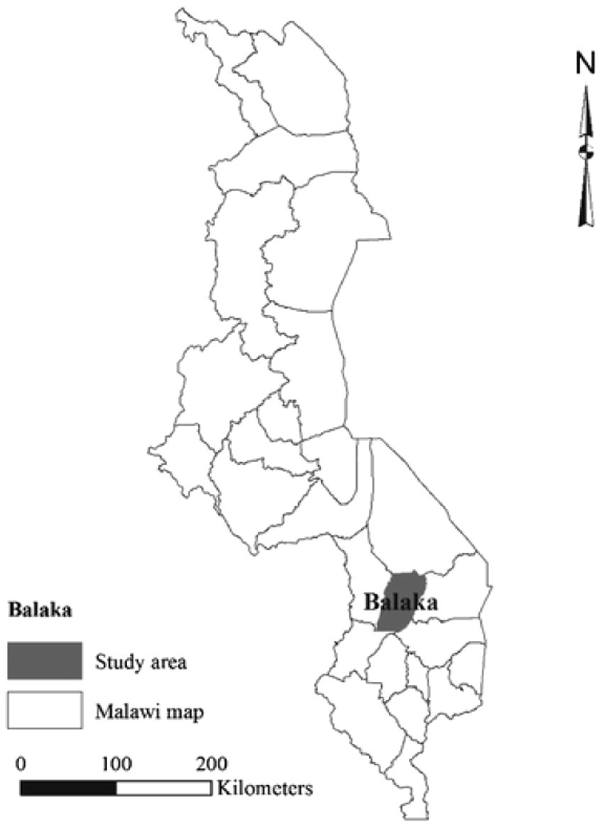
Figure 1. The geographical location of Balaka, in southern Malawi.
Balaka is divided into four regions: south, north, central east, and west, with 10 traditional authority (Table 1). Our investigation was conducted in five villages: Uchendausiku, Liwawadzi, Mchenga, Khwisa, and Kachenga (Figure 2), which included three traditional authorities. Maize, rice, sweet potatoes, and sorghum are the most commonly cultivated food crops. Agriculture in Malawi is separated into two categories: small-scale farms and estates.
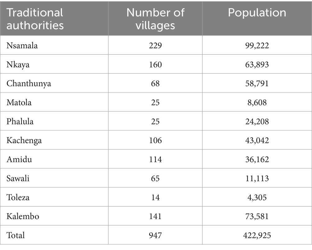
Table 1. Demographics of the traditional authorities in Balaka District.
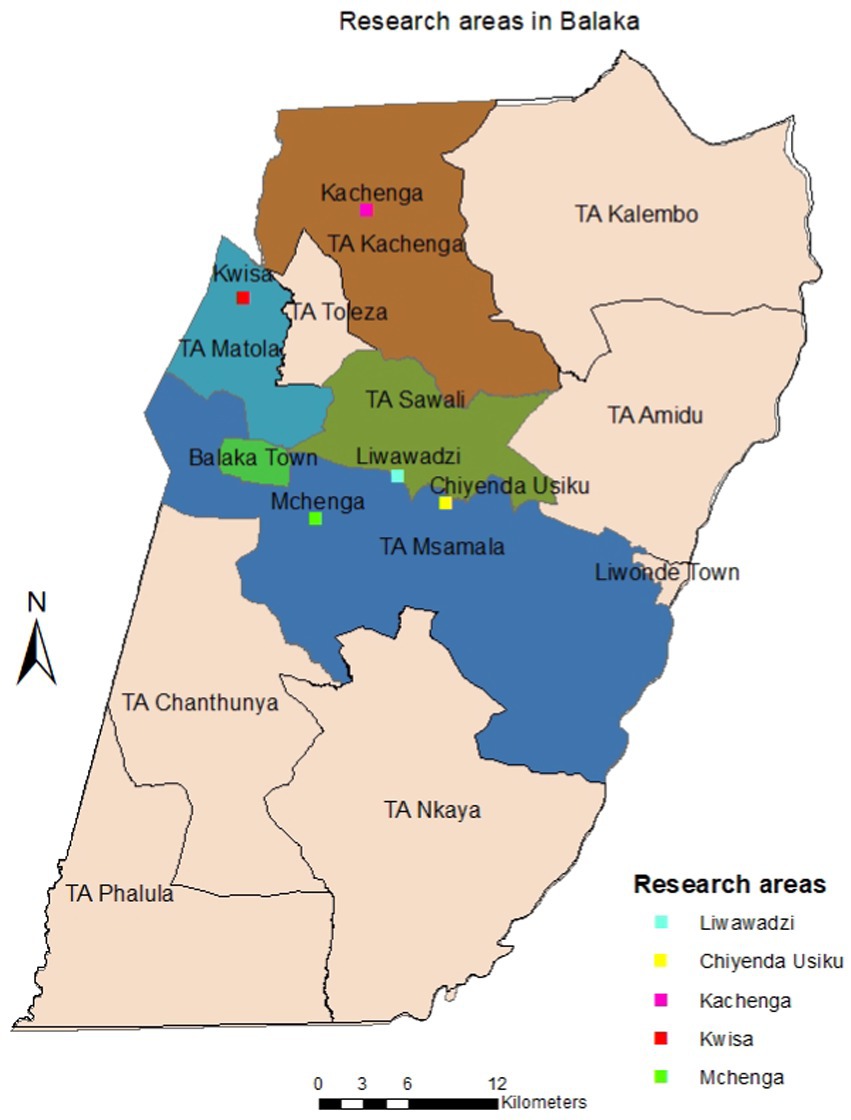
Figure 2. Location of the five villages in Balaka District where the study was carried out.
Malawi has extremely diverse physical features that are divided into four major physiographic zones: the highlands in the south, the plateau in the center and north, the Rift Valley escarpment, and the Rift Valley plains along Lake Malawi’s shoreline (Mzuza et al., 2019; Li et al., 2017; Lemenkova, 2021). Balaka District is located on the eastern end of the Great Rift Valley and has a varied landscape with elevations ranging from 350 to 800 m above sea level. Malawi receives 700–2,400 mm of rainfall per year, with an average of 1,180 mm. Rainfall distribution is mostly determined by topography and proximity to Lake Malawi. High altitude and mountainous places receive the most rainfall, whereas low-lying and rain shadow areas like Balaka receive the least. Balaka has one of the lowest annual rainfall levels in the country, with an average of 768 mm (Msume et al., 2022). The optimal time for rainfed agricultural output is between December and March, when soils are moist. Temperature is also affected by topography, and it lowers as altitude increases.
The average maximum and minimum temperatures in plateau areas are 28°C and 10°C, respectively, whereas in the Rift Valley lowlands they are 32°C and 14°C. Balaka has a warm to hot climate, with an average annual temperature of 25°C. In general, warm temperatures do not significantly impact agricultural productivity. However, in Balaka, high temperatures are commonly associated with drought (Li et al., 2017).
Malawi has abundant water sources, such as lakes, rivers, and aquifers. There are two primary aquifers: the Precambrian weathered basement complex and the Quaternary alluvial aquifers in the lake shoreline plains and lower Shire Valley. The two major drainage systems are Lake Malawi, Africa’s third-largest freshwater lake, and Lake Chilwa (Rivett et al., 2020). Although Malawi has abundant water sources, it is worth noting that Balaka does not have adequate groundwater resources. A known groundwater source is a low-yielding basement aquifer in the plateau area of Dziwe, southeast of Balaka.
Most surface water sources are non-perennial, placing agricultural sustainability at risk. Water scarcity also leads to salinization, which is one of the processes of land degradation. Balaka District has three major types of vegetation: closed canopy woodlands, woodland or savannah (mixed species), and mopane. The Shire Valley features tiny sections of perennial wet grassland, open canopy woodlands, hills, and scarps. The district’s soils are predominantly alluvial and calcimorphic (Hegedorn et al., 2001). There are medium-textured sandy soils along the Shire River, sandy loam to clay sandy soils with medium textures in the upper Balaka plain, and heavy-textured sandy medium and shallow stone soils in the upper Ulongwe and Bazale regions. Phalula is known for its gravel and loam soils, whereas Utale is known for its sandy loams, clay sands, and sandy soils of medium texture. Land usage and classification are determined by soil type, fertility level, and characteristics. The soil’s properties determine its vulnerability to erosion and degradation.
Methodology
The mixed qualitative domination approach was used in this study. We conducted 100 semi-structured interviews with farmers in Balaka. One hundred participants from five villages: Khwisa, Liwawadzi, Uchendausiku, Mchenga, and Kachenga (20 farmers per village). The villages were chosen based on their unique geographical qualities. The rationale for choosing areas with diverse geographical characteristics is that they are more likely to face distinct problems and adapt differently to changing environmental conditions. This allowed us to get a complete picture that was representative of all the communities in the area under investigation.
The snowball sampling technique was most appropriate for our research because Balaka is a region made up of villages, some of which are remote. Other researchers (Naderifar et al., 2017) agree that this is the best technique for conducting studies in remote or difficult-to-locate areas. Specifically, we used linear snowball sampling in each village, starting with the chief as our primary source and moving on to the other participants. We conducted interviews with farmers in each village until the data was saturated. After conducting 20 interviews in each village, the researchers were convinced that any extra data collection would not yield valuable insights.
All interviews took place on each participant’s farm, and a topic guide was used to ensure that the discussion included all components of indigenous knowledge investigated in this study.
We utilized semi-structured interviews as they allowed us to have regular conversations with the farmers, eliminating the unequal power dynamic between the interviewer and the interviewee. Ethical compliance was maintained throughout the study, and participants were informed that the study was completely voluntary and that they (the participants) might withdraw from the interview at any point.
The interviews were conducted in Chichewa because English was not the farmers’ native language, and they needed to be able to express themselves freely and comfortably. Photographs were shot on farms only once the applicable farmer given permission. Participatory observation was implemented for a more authentic experience. We then used Atlas-ti software to conduct thematic content analysis. The data was classified into five categories based on each farmer’s indigenous perception of: land degradation indicators, causes of land degradation, land management strategies, and definition of land degradation.
Results
The findings show Balaka is primarily a crop-farming community where various crops are grown (Figure 3). The most widely farmed crop is maize, which is grown by all the farmers interviewed, followed by penguin peas, peanuts, cotton, and sugarcane. Chichewa farmers use the term “Ntaka ya guga” to describe land degradation. When directly translated into English, it means ‘the land is old’. Farmers use three variables to evaluate the quality of their land: soil fertility, crop quality, and quantity.
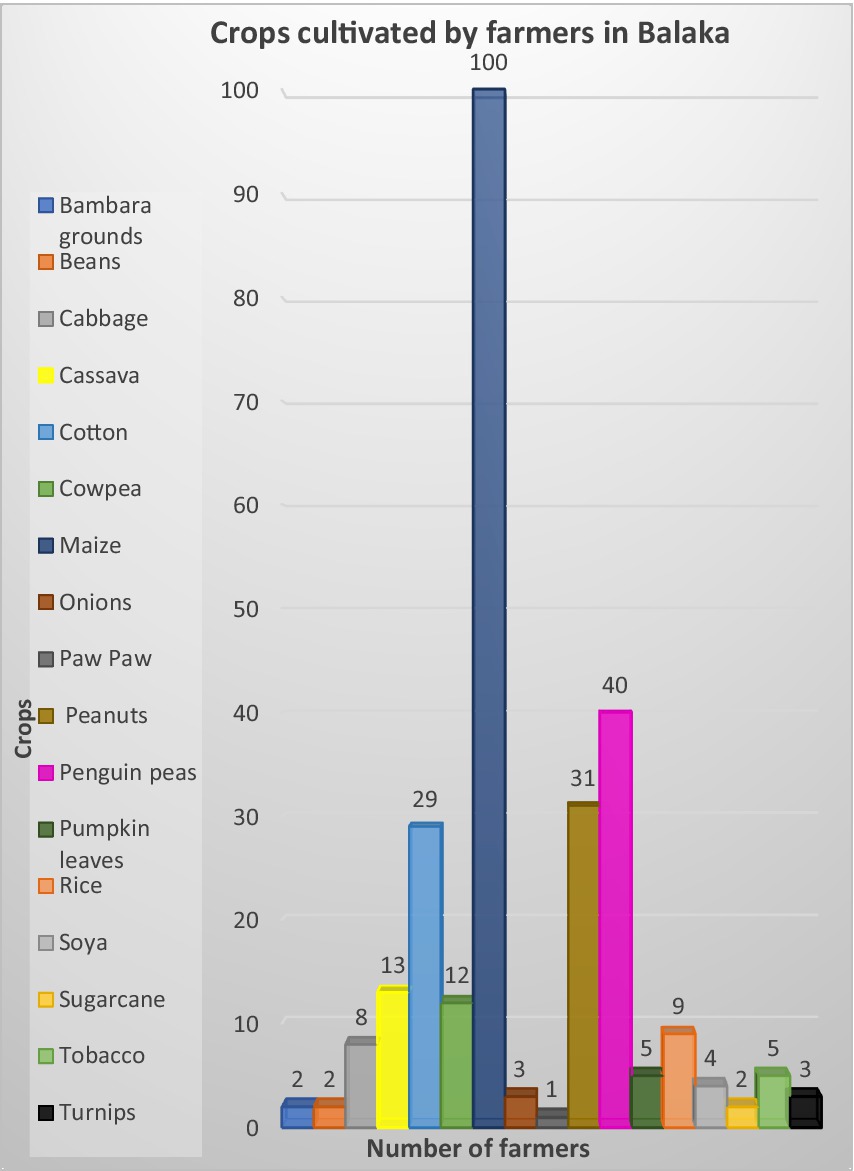
Figure 3. Crops cultivated by farmers in Balaka.
Indicators
Our findings demonstrate that farmers use multiple indicators (Table 2) to determine whether or not their land has degraded. However, it is worth noting that the top three reported indicators are crop failure (31%), fertilizer reliance (28%), and decline in crop productivity (16%), all of which are related to how they define land degradation.
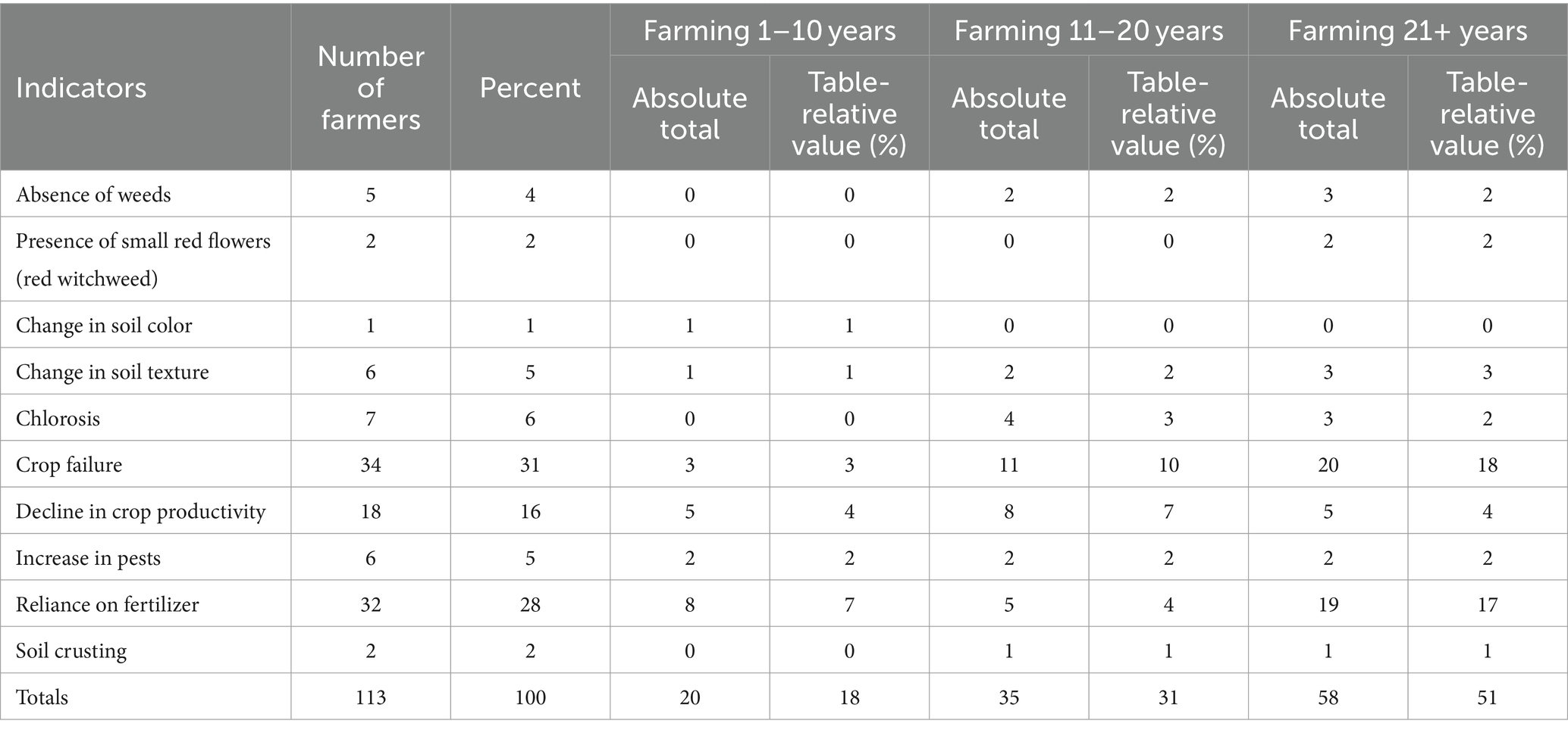
Table 2. Land degradation indicators reported by farmers in Balaka.
Causes
The findings indicate that farmers in Balaka recognize that natural and human factors cause land degradation. The farmers identified five primary causes of land degradation: unsustainable practices (42%), extreme weather conditions (33%), chemical inputs (20%), population growth (3%), and urban expansion (2%). Farmers believe that unsustainable farming is caused by deforestation, prolonged farming, and shifting cultivation through agricultural burning. They identified deforestation as the root cause of land degradation in Balaka.
One of the farmers explained that “soil erosion is prevalent because of deforestation, which causes vulnerable soil to loosen and become susceptible to erosion (specifically by water). Soil crusting becomes evident, and farmers cannot use the soil productively.”
The farmers brought up drought and flooding as examples of harsh weather. Every farmer brought up the 2019 storm Idai, which severely flooded Malawi. They also mentioned that extreme weather events are happening more frequently, something else worth noting. “A few years before the devastation brought about by Cyclone Idai, Malawi had experienced a succession of extreme flood (in 2015 and 2018) and drought (in 2016 and 2017) events in quick succession,” one of the farmers reported.
Farmers who blamed population growth and urban expansion as causes of land degradation in Balaka said that there are more people and farmers in the area than before. A farmer said that the “increase in population is evident based on the decreased quantity of subsidized fertilizer received from the government program.” Farmers also stated that population growth is causing urban expansion, which is negatively affecting the natural environment. One of the farmers said, “In Khwisa, the construction of a road created modifications to the episodic stream. The modifications disrupted a perennial stream that flows through the settlement, resulting in flooding of farms near the stream.” Another participant repeated this claim by stating that “we as the community built a buffer to control flooding events that occur with an episode of rainfall and the buffer assisted in controlling the flooding however collapsed (Figure 4) as it was not stable enough to withstand the velocity and strength of the stream.”
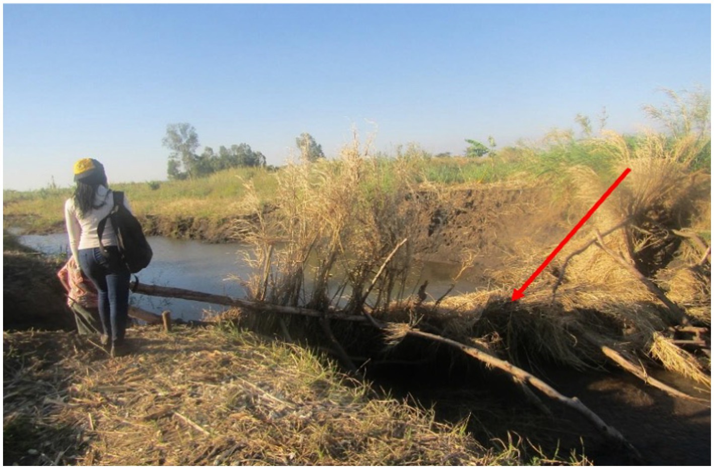
Figure 4. A picture showing the collapsed buffer. The red arrow points to the collapsed buffer.
Strategies
Farmers’ indigenous adaptation strategies can be divided into two categories. Adaptive strategies for maintaining soil quality and managing irrigation water. Farmers practice crop rotation, afforestation, fallow periods, and crop regeneration to prevent land degradation and maintain soil quality. They also use manure and compost (vegetable farm waste), prohibiting deforestation and agricultural burning (Table 3).
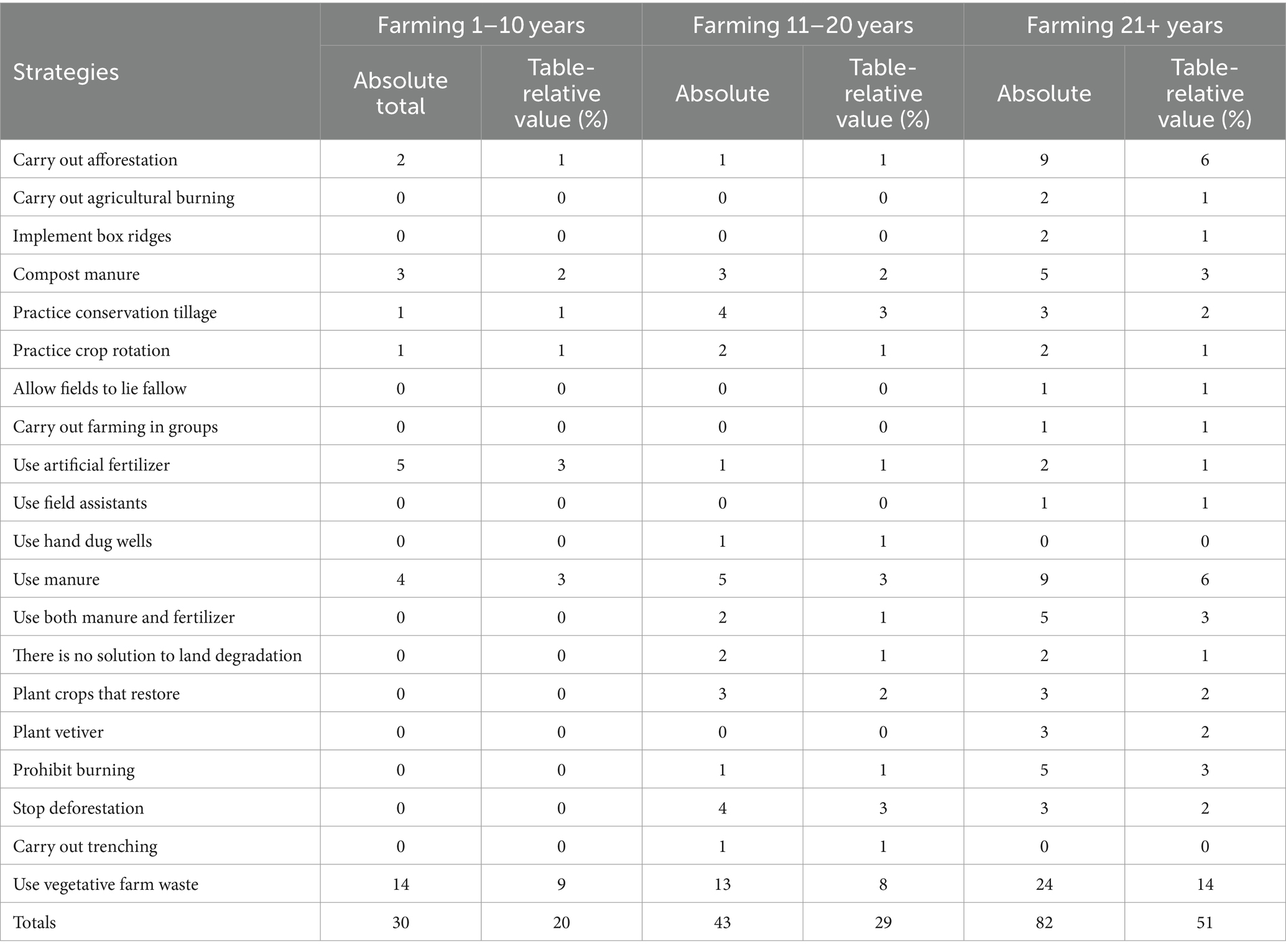
Table 3. A breakdown of the coping strategies adopted by Balaka farmers.
Farmers in Balaka use indigenous practices such as hand-dug wells for water storage, planting vetiver to reduce flooding, conservation tillage, trenching, and box ridges (Figure 5). It’s also worth noting that some farmers say there are no practical techniques for combating land degradation or adapting to changing environmental conditions.
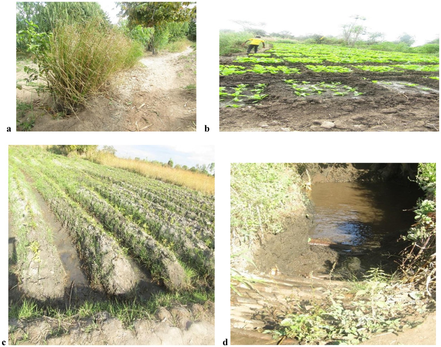
Figure 5. Water management strategies in Balaka (a) Vetiver plants are placed in rows to create a hedge, a living porous barrier that slows and spreads runoff water while trapping sediment; (b) box ridges help to keep rainwater from flowing over the soil surface rather than soaking into the ground, where it can be used by crops; (c) trenching helps to capture water as it runs downhill and retains it on the agricultural ground, and (d) hand-dug well.
Discussion
Perceptions influence consciousness, goals, and practical behaviors (Pulido and Bocco, 2014). As the results reveal, how land degradation is defined is significant since it influences both the indicators used and the need to take action against land degradation. According to Rabumbulu and Badenhorst (2016), land degradation pertains to the biological and economic productivity of the land.
The results reveal that farmers in Balaka solely focus on the economic productivity of the soil, and they can benefit significantly by broadening their indigenous definition to include the biological activity of the soil. Their definition should also include soil erosion caused by significant depletion of vegetative matter, bush encroachment, and shrub invasion of grasslands (Hongslo et al., 2009; Rabumbulu and Badenhorst, 2016; Pacheco et al., 2018; Rabumbulu and Masithela, 2022).
Indicators
Simply said, an indicator is something that represents a state or trend in environmental or socio-cultural conditions over a specific area and period. Although Balaka uses a variety of indigenous indicators, it is clear that not all farmers use the same number of indicators (Table 2). Indicators are critical instruments for monitoring environmental changes, assessing performance, and making decisions; consequently, farmers in Balaka must use all indicators that can help them detect land degradation from the very beginning. Our findings are consistent with those from similar studies. Kusima and Yiran (2011), Descheemaeker et al. (2016), Kok et al. (2016), and Ahmed et al. (2017) discovered that farmers primarily use physical characteristics such as soil crusting, changes in soil color and texture, and the appearance and disappearance of specific plant species as indicators of land degradation. These are physical changes that farmers observe over time. According to Atera (2012), the presence of the red flower, known as Kaufiti (Table 2) in Chichewa (scientific name Striga asiastica), relates to a decrease in crop productivity, particularly in legumes like groundnuts, bambara beans, and common beans. Crops failure, reliance on fertilizer, and decreased agricultural productivity are all common indications.
The findings reveal that farmers with more experience use more indicators than those with less experience. This could be because indigenous knowledge is primarily oral, with more knowledge acquired through observation and experience (Obi et al., 2021; Rabumbulu and Masithela, 2022). Science, on the other hand, maintains records of knowledge and data that it uses to establish a baseline (Bwambale et al., 2020). A baseline ensures everyone begins with the same amount of information. Farmers in Balaka can establish an indigenous indicator baseline to bridge the gap between farmers with little and extensive experience. Farmers utilize comparable indications to scientists. The only distinction is that indigenous indicators are qualitative, whereas scientists typically quantify changes.
Indigenous farmers can increase their adaptability by quantifying certain components. Components such as soil texture, chemical content, and spatial distribution can be quantified.
Causes
Land degradation caused by anthropogenic activity is well documented (Holmes et al., 2012; Rabumbulu and Badenhorst, 2016; Chopra, 2016; Megerssa and Bekere, 2019; Pandit et al., 2020; Kouassi et al., 2021). Unsustainable farming practices degrade the environment and have long-term implications (Bernard and Lux, 2017).
Farmers’ perceptions proved crucial in identifying and addressing unsustainable practices such as intensive agriculture, shifting cultivation, agricultural burning, and deforestation. It is essential to highlight that in Malawi and other African countries, some of these processes are driven by activities other than agriculture. High demand for fuelwood contributes to deforestation. Deforestation and poor farming practices exacerbate soil erosion (Wairin, 2017). Farmers in Balaka believe manure and compost are better alternatives to artificial fertilizers. Farmers, on the other hand, feel driven to use chemical fertilizers because they believe they are more effective and help crops to grow faster. Changes in the environment and climate cause a rise in pests, which raises chemical inputs through pesticide and herbicides. According to research, using chemical substances can harm the environment (Nave et al., 2013). Although farmers frequently mention an increase in chemical inputs (pesticides and fertilizers) as a cause of land degradation, they fail to consider the possibility that they are applying the wrong fertilizers to their soil. Farmers in Balaka buy fertilizers based on the brands everyone else uses without considering their specific soil needs. Scientific information can be used to educate farmers on how to apply fertilizers correctly on various soil types. Correct application of fertilizers will help farmers reduce land degradation and boost crop yields.
Farmers in Balaaka identified extreme weather patterns as one of the primary causes of land degradation in the Balaka region. Farmers reported periods of drought followed by flooding. Trouè et al. (2019) did a study in Mali and found that agricultural drought (drought affecting rain-fed crops) affects the water available for crops. Droughts also accelerate soil erosion by reducing vegetation cover. High rainfall amounts on degraded soils with little vegetation cover causes increased runoff, soil erosion, evaporation, and decreased water availability for optimal crop productivity. Harvey et al. (2014) confirm that climate changes result in a decrease in agricultural production. It also causes a rise in pest and disease outbreaks, contributing to land degradation.
Although weather cannot be controlled, having a solid understanding of it can help farmers plan more effectively. The results show that farmers only focus on specific components of weather, primarily rainfall, without considering other factors such as temperature, wind, and humidity.
Indigenous forecasting relies on previous experiences and observations of ecological indicators (Rabumbulu and Masithela, 2022; Nyadzi et al., 2022). Such as variations in animal behavior, the arrival or disappearance of specific animal or bug species, and changes in cloud and wind directions. Farmers can increase accuracy by considering all atmospheric factors and employing consensus forecasting techniques. Plotz et al. (2017) investigate how consensus forecasting was successfully implemented in Kenya and Tanzania. In Kenya, the Nganyi tribe is well-known for their rainfall forecasting skills. Eleven tribes collaborate to agree on area forecasts, and once agreed upon, they meet with the Kenya Meteorological Department annually. They both provide regional forecasts, and any disagreements are discussed, and explanations are given for each. Next year, both will evaluate the accuracy of their previous estimates.
Strategies
Farmers in Balaka use a variety of strategies, including afforestation, manure application, compost production, and crop diversification. Planting different crops can help farmers boost crop output through nitrogen fixation since legumes like cowpeas and soybeans create large amounts of biomass (Asfaw et al., 2020). Furthermore, trees have a significant function in the environment; as proven in Eastern and Southern Africa by researchers such as Hidayat (2010), Turner-Skoff and Cavender (2019), and Ojeh et al. (2020), afforestation promotes recovery.
Although these measures efficiently reduce erosion and replenish soil nutrients, some have unintended consequences. The farmers also stated that composting vegetative waste increases the quantity of pests. This forces farmers to use agricultural burning as a pest control approach. This method is also problematic because it contributes to soil degradation. Although burning increases the availability of nutrients in topsoils (Amoaka and Gambiza, 2019; Rabumbulu and Masithela, 2022), excessive burning has detrimental implications. The key issue is how farmers compost (Figure 6). This issue can be readily resolved by using composting bins, which scientists use. Although introducing the use of compost bins will cost money, it still makes economic sense given that farmers will no longer have to spend money on pesticides and will have higher crop yields.
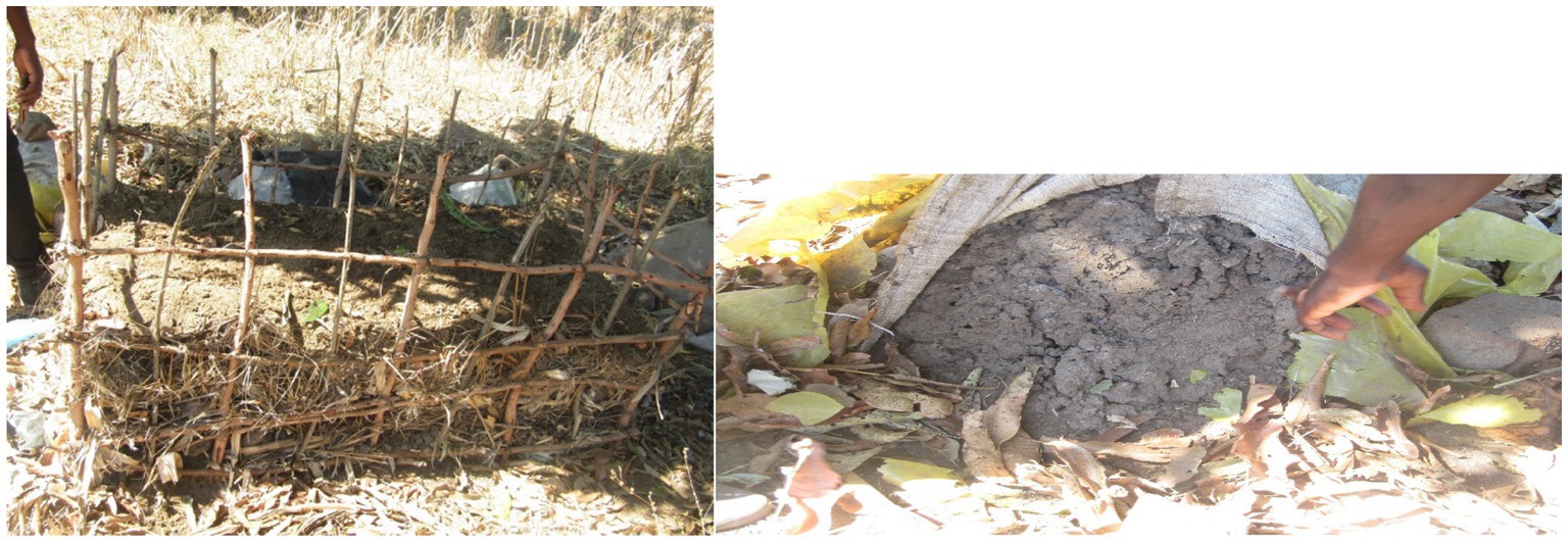
Figure 6. Composting techniques implemented by the farmers.
Farmers’ highest priority in mitigating the effects of extreme weather patterns such as drought and floods is water conservation and irrigation. Farmers only use water conservation measures as an adaptation technique after experiencing unfavorable conditions. Measures such as box ridges, hand-dug wells, and trenches were employed to store water or prevent runoff on farms.
Farmers in Balaka use techniques similar to those used by indigenous farmers throughout Africa. Farmers in Ethiopia’s northern drylands dig contour furrows or trenches, which function as wells for storing water for use during dry seasons and as a runoff control technique (Blazin et al., 2012). Rainwater harvesting techniques are widely used in Tanzania due to water scarcity. The utilization of furrows and dug-out ponds has resulted in increased crop production. Conservation tillage is a practice employed during severe droughts. Asmamaw (2014) analyses the success of conservation tillage in Ethiopia’s highlands, with farmers reporting that it lowers land degradation by restoring and improving soil fertility.
As with the indicators, there is a clear variation in knowledge levels between farmers with more and less experience. This knowledge gap can be overcome by encouraging farmers to engage in discussions. Othman et al. (2020) discovered that forming farming groups assists farmers (mainly women) by providing them with access to information about seeds, fertilizers, pesticides, and tools. Farmers can also learn about heat-tolerant and drought-resistant seeds. Zeweld et al. (2018) found that social capital in the form of group participation is useful in aiding farmers in various ways.
Farmers share agricultural techniques, support one another in the farming sector, and help one another overcome resource constraints. This may also help farmers who believe there are no solutions (Zama et al., 2021).
Traditional hand-dug wells are less expensive but take longer to construct and require a lot of labor. Rising temperatures and more frequent droughts will reduce water levels in aquifers over time. Farmers can profit from employing contemporary technology to dig deeper. Haile et al. (2006) presents the modernization of Eritrea’s Wadi Laba spate irrigation, which was initially created from an indigenous irrigation system with two main canals. The canals were designed to distribute water as it entered the fields. The irrigation system required several changes to improve its performance, including canal head regulator valves to catch fine sediments. The second significant upgrade was the rejection weir, which released the water flow back into Wadi if it exceeded 38 ms−1. This integrated system manages floods, resulting in soils with good infiltration.
Conclusion
The study found that farmers have extensive knowledge and awareness of land degradation. Farmers in Balaka are aware of the changes in their environment and have presented a wide range of land degradation indicators and adaptation strategies. These findings provided insight into farmers’ comprehension and knowledge of the land degradation phenomena. Indicators identified were mostly based on farmers’ own observations of their land, however the majority of them were related to physical changes in the land rather than biological changes. Nonetheless, the data supplied reveal that farmers are continually monitoring their environment. The current study also found a direct link between farming experience (in years) and understanding of land degradation indicators. Farmers with more years of farming experience displayed a better awareness of land degradation markers. They also employ more indicators and adaption measures than farmers with less experience.
Land degradation is frequently viewed as an environmental issue but is rarely addressed as a social one. In this context, the social aspect would be farming in groups and relying on extension services such as field assistants. Balaka district should establish a farmer-scientist organization that will meet regularly to collaborate and work together. Farmers’ perspectives of the indicators and causes of land degradation and land management solutions to combat land degradation are purely based on their practical observations and experiences. This demonstrates that indigenous knowledge should not be considered an irrelevant knowledge system in modern times. Scientific practices should be encouraged and integrated into current strategies. The role that geophysical factors play in land degradation has not been addressed. More research is needed to determine how much each of the geophysical causes contributes to degradation in this location. Future studies can use remote sensing techniques to monitor changes in land degradation over time.
Data availability statement
The raw data supporting the conclusions of this article will be made available by the authors, without undue reservation.
Ethics statement
The studies involving humans were approved by the University of Johannesburg, Faculty of Science Ethics Committee. The studies were conducted in accordance with the local legislation and institutional requirements. The Ethics Committee/Institutional Review Board waived the requirement of written informed consent for participation from the participants or the participants’ legal guardians/next of kin because not all participants can read and write so they provided verbal consent.
Author contributions
VC: Data curation, Formal analysis, Writing – original draft. MR: Conceptualization, Methodology, Supervision, Writing – review & editing.
Funding
The author(s) declare that no financial support was received for the research, authorship, and/or publication of this article.
Acknowledgments
Thank you to Stephen Daniel Kanjobvu of the Balaka District Agriculture Office for his support and insights about farming in and around Balaka. Edgar Chihana of the Balaka District Council for his readiness to assist, and Mike Julius for his guidance during the fieldwork. Thanks to all the farmers for cooperating and sharing their expertise and experiences. Thank you to the reviewers for their comments, which significantly enhanced this paper.
Conflict of interest
The authors declare that the research was conducted in the absence of any commercial or financial relationships that could be construed as a potential conflict of interest.
Publisher’s note
All claims expressed in this article are solely those of the authors and do not necessarily represent those of their affiliated organizations, or those of the publisher, the editors and the reviewers. Any product that may be evaluated in this article, or claim that may be made by its manufacturer, is not guaranteed or endorsed by the publisher.
References
Acocks, J. P. H. (1988). Veld types of South Africa (3rd edition). Mem. Bot. Surv. S. Afr. 57, 1–146.
Adenle, A. A., and Speranza, C. I. (2022). Key dimensions of land users’ perceptions of land degradation and sustainable land management in Niger State, Nigeria. Environ. Challenges 8, 1–13. doi: 10.1016/j.envc.2022.100544
Ahmed, M. H., Geleta, K. M., Tezeza, A., Mesfin, H. M., and Tilahun, E. A. (2017). Cropping systems diversification, improved seed, manure and inorganic fertilizer adoption by maize producers of eastern Ethiopia. J. Econ. Struct. 6, 1–16. doi: 10.1186/s40008-017-0093-8
Ammann, K. (2007). “Reconciling traditional knowledge with modern agriculture: a guide for building bridges” in Intellectual property in health and agricultural innovation. eds. A. Krattiger, R. T. Mahoney, and L. Nelsen (United Kingdom: Oxford).
Amoaka, E. E., and Gambiza, J. (2019). Effects of anthropogenic fires on some soil properties and the implications of fire frequency for the Guinea savanna ecological zone, Ghana. Sci. Afric. 6, 1–10. doi: 10.1016/j.sciaf.2019.e00201
Archer, E. R. M. (2004). Beyond the “climate versus grazing” impasse: using remote sensing to investigate the effects of grazing system choice on vegetation cover in the eastern Karoo. J. Arid Environ. 57, 381–408. doi: 10.1016/S0140-1963(03)00107-1
Asfaw, S., Pallante, G., and Palma, A. (2020). Distributional impacts of soil erosion on agricultural productivity and welfare in Malawi. Ecol. Econ. 177, 1–17. doi: 10.1016/j.ecolecon.2020.106764
Asmamaw, D. K. (2014). Conservation tillage implementation under rainfed agriculture: implication of soil fertility, green water management, soil loss and grain yield in the Ethiopian Highland. Int. J. Agric. Sci. 4, 268–280.
Atera, E. (2012). Farmers’ perception and constraints to the adoption of weed control options: the case of Striga asiatica in Malawi. J. Agric. Sci. 5, 41–50. doi: 10.5539/jas.v4n5p41
Balay-As, M., Marlowe, J., and Gaillard, J. C. (2018). Deconstructing the binary between indigenous and scientific knowledge in disaster risk reduction: approaches to high impact weather hazards. Int. J. Disaster Risk Reduct. 3, 18–24. doi: 10.1016/j.ijdrr.2018.03.013
Bernard, B., and Lux, A. (2017). How to feed the world sustainably: an overview of the discourse on agroecology and sustainable intensification. Reg. Environ. Chang. 17, 1279–1290. doi: 10.1007/s10113-016-1027-y
Blazin, B., Sterk, G., Temesgen, M., Abdulkedir, A., and Stroosnijder, L. (2012). Rainwater harvesting and management in rainfed agricultural systems in sub-Saharan Africa-a review. Phys. Chem. Earth 48, 139–151. doi: 10.1016/j.pce.2011.08.015
Bwambale, B., Nyeko, M., Muhumuza, M., and Kervyn, M. (2020). Questioning knowledge foundation: what is the best way to integrate knowledge to achieve substantial disaster risk reduction. Int. J. Disaster Risk Reduct. 51, 1–12. doi: 10.1016/j.ijdrr.2020.101850
Chopra, R. (2016). Environmental degradation in India: causes and consequences. Int. J. Appl. Sci. 11, 1593–1601.
Cullen-Unsworth, L. C., Hill, R., Butler, J. A., and Wallace, M. (2012). A research process for integrating indigenous and scientific knowledge in cultural landscapes: principles and determinants of success in the wet tropics world heritage area, Australia. Geogr. J. 178, 351–365. doi: 10.1111/j.1475-4959.2011.00451.x
Descheemaeker, K., Ronner, E., Ollenburger, M., Franke, A. C., Klapwijk, C. J., Falconnier, G. N., et al. (2016). Which options fit best? Operationalizing the socio-ecological niche concept. Exp. Agric. 55, 169–190. doi: 10.1017/S001447971600048X
Haile, M., Herweg, K., and Stillhardt, B. (2006). Sustainable land management: a new approach to soil and water conservation in Ethiopia. Mekelle, Ethiopia: Land Resources Management and Environmental Protection Department, Mekelle University; Bern, Switzerland: Centre for Development and Environment (CDE), University of Bern, and Swiss National Centre of Competence in Research (NCCR) North-South.
Harvey, C. A., Rakotobe, Z. L., Rao, N. S., Dave, H. R., Rabarijohn, R. H., Rajaofara, H., et al. (2014). Extreme vulnerability of smallholder farmers to agricultural risks and climate change in Madagascar. Philos. Trans. Roy. B Soc. 369, 1–12. doi: 10.1098/rstb.2013.0089
Hegedorn, F., Patrick, S., Waldner, P., and Flühler, H. (2001). Export of dissolved organic carbon and nitrogen from gleysol dominated catchments- The significance of water flowpaths. Biochem. 50, 137–161. doi: 10.1023/A:1006398105953
Hermann, S., Dioul, A. A., and Sall, I. (2020). Beyond bioproductivity: engaging local perspectives in land degradation monitoring and assessment. J. Arid Environ. 173, 1–5. doi: 10.1016/j.jaridenv.2019.104002
Hidayat, I. (2010). The ecological role of trees and their interactions in forming the microclimate amenity of the environment. J. Bumi Lestan 10, 1–9. doi: 10.5281/zenodo.1067926
Holmes, P. J., Thomas, D. S. G., Bateman, M. D., Wiggs, G. F., and Rabumbulu, M. (2012). Evidence for land degradation from aeolian sediment in the west Central Free State Province, South Africa. Land Degrad. Dev. 23, 601–610. doi: 10.1002/ldr.2177
Hongslo, E., Rhode, R., and Hoffman, T. (2009). Landscape change and ecological processes in relation to land-use in Namaqualand, South Africa, 1939 to 2005. S. Afr. Geogr. J. 92, 63–74. doi: 10.1080/03736245.2009.9725333
Jayne, T. S., Snapp, S., Place, F., and Sitko, N. (2018). Sustainable agricultural intensification in an era of rural transformation in Africa. Glob. Food Sec. 20, 105–113. doi: 10.1016/j.gfs.2019.01.008
Kirui, O. K., and Mirzabaev, A. (2014). Economics of land degradation in Eastern Africa. ZEF working paper series no. 128. Bonn: Center for Development Research.
Kirui, O. K., Mirzabaev, A., and Von Braun, J. (2021). Assessment of land degradation ‘on the ground’ and from ‘above’. SN Appl. Sci. 3, 1–13.
Kok, M., Lüdeke, M., Lucas, P., Sterzel, T., Walther, C., Janssen, P., et al. (2016). A new method for analysing socio-ecological patterns of vulnerability. Reg. Environ. Chang. 16, 229–243. doi: 10.1007/s10113-014-0746-1
Kopittke, P. M., Menzies, N. W., Wang, P., Mckenna, B. A., and Lombi, E. (2019). Soil and the intensification of agriculture for global food security. Environ. Int. 132, 1–8. doi: 10.1016/j.envint.2019.105078
Kouassi, J., Gyau, A., Diby, L., Bene, Y., and Kouamé, C. (2021). Assessing land use and land cover change and farmers’ perception of deforestation and land degradation in South-West Côte d’Ivoire, West Africa. Land 10, 1–25. doi: 10.3390/land10040429
Kusima, J. M., and Yiran, G. A. B. (2011). Application of local knowledge in land degradation assessment in the Bawiku east Muncipality. Ghana J. Geogr. 3:184.
Le Houerou, H. N. (1996). Climate change, drought and desertification. J. Arid Environ. 34, 133–185. doi: 10.1006/jare.1996.0099
Leach, M., and Mearns, R. (1996). The lie of the land: challenging received wisdom on the African environment. International African Institute, Oxford: James Currey.
Lemenkova, P. (2021). Mapping earthquakes in Malawi using incorporated research institution of seismology (IRIS) catalogue for 1972-2021. Malawi J. Sci. Technol. 13, 31–50.
Li, G., Messina, J. P., Peter, B. G., and Snapp, S. S. (2017). Mapping land suitability for agriculture in Malawi. Land Degrad. Dev. 28, 2001–2016. doi: 10.1002/ldr.2723
Magn, G. (2017). Indigenous knowledge and implications for the sustainable development agenda. Int. Bureau Educ. 52, 437–447. doi: 10.1111/ejed.12238
Megerssa, G. R., and Bekere, B. Y. (2019). Causes, consequences and coping strategies of land degradation: evidence from Ethiopia. J. Degrad. Min. Lands Manag. 7, 1953–1957. doi: 10.15243/jdmlm.2019.071.1953
Msume, A. P., Mwale, F. D., and Castelli, G. (2022). Inventory and drivers of the adoption of flood-based farming systems in South-Eastern Africa: insights from Malawi. Irrig. Drain. Syst. 71, 521–533. doi: 10.1002/ird.2664
Mzuza, M. K., Zhang, W., Kapute, F., and Wei, X. (2019). “Impact of land use and land cover changes on the Nkula Dam in the middle Shire river catchment, Malawi” in Geospatial analyses of the earth observation data. eds. A. Pepe and G. Zhao (London: Intechopen).
Naderifar, M., Goli, H., and Ghaljaie, F. (2017). Snowballing sampling: a purposeful method of sampling in qualitative research. Strides Dev. Med. Educ. 14, 1–7. doi: 10.5812/sdme.67670
Nave, S., Jacquet, F., and Jeuffroy, M. (2013). Why wheat farmers could reduce chemical inputs: evidence from social, economic, and agronomic analysis. Agron. Sustain. Dev. 33, 795–807. doi: 10.1007/s13593-013-0144-y
Noyoo, N. (2007). Indigenous knowledge systems and their relevance for sustainable development: a case of southern Africa. Tribes Tribals 1, 167–172.
Nyadzi, E., Werners, S. E., Biesbroek, R., and Ludwig, F. (2022). Towards weather and climate services that integrate indigenous and scientific forecasts to improve forecast reliability and acceptability in Ghana. Environ. Dev. 42:227. doi: 10.1016/j.envdev.2021.100698
Obi, R., Nwachukwu, M. U., Okeke, D. C., and Jiburum, U. (2021). Indigenous flood control and management knowledge and flood disaster risk reduction in Nigeria's coastal communities: an empirical analysis. Int. J. Disaster Risk Reduct. 55:102079. doi: 10.1016/j.ijdrr.2021.102079
Ojeh, V. N., Philip-Humshie, A., Garba, H. A., and Naabil, E. (2020). The environmental benefits of trees in a changing climate: a Nigerian experience. J. Sci. Res. Rep. 26, 59–75.
Othman, M. S., Oughton, E., and Garrod, G. (2020). Significance of farming groups for resource access and livelihood improvement of rural smallholder women farmers. Dev. Pract. 30, 586–598. doi: 10.1080/09614524.2020.1764502
Pacheco, F. A. L., Fernandes, L. F. S., Valle, R. F. Jnr, Valera, C. A., and Pissarra, T. C. T. (2018). Land degradation: multiple environmental consequences and routes to neutrality. Curr. Opin. Environ. Sci. Health 5, 79–86. doi: 10.1016/j.coesh.2018.07.002
Pandit, R., Parrotta, J. A., Chaudhary, A. K., Karlen, D. L., Vieira, D. L. M., Anker, Y., et al. (2020). A framework to evaluate land degradation and restoration responses for improved planning and decision-making. Ecosyst. People 16, 1–18. doi: 10.1080/26395916.2019.1697756
Plotz, R. D., Chambers, L. E., and Finn, C. K. (2017). The best of both worlds: A decision-making framework for combining traditional and contemporary forecast systems. J. Appl. Meteorol. Clim. 56, 2377–2392. doi: 10.1175/JAMC-D-17-0012.1
Prince, S. D., Becker-Reshef, I., and Rishmawi, K. (2009). Detection and mapping of long-term land degradation using local net production scaling: application to Zimbabwe. Remote Sens. Environ. 113, 1046–1057. doi: 10.1016/j.rse.2009.01.016
Pulido, J., and Bocco, G. (2014). Local perception of land degradation in developing countries: a simplified analytical framework of driving forces, processes, indicators and coping strategies. Living Rev. Landscape Res. 8, 1–21. doi: 10.12942/lrlr-2014-4
Rabumbulu, M., and Badenhorst, M. (2016). Land degradation in the west-central Free State: human induced or climate variability, the perceptions of Abrahamskraal-Boshof district farmers. S. Afr. Geogr. J. 99, 217–234. doi: 10.1080/03736245.2016.1231623
Rabumbulu, M., and Masithela, I. (2022). “Highlighting avenues to reconcile indigenous and scientific knowledge to address climate change and land degradation in Lesotho: a case study of the Maseru District” in Indigenous knowledge and climate governance. eds. E. E. Ebhuoma and L. Leonard (Cham, Switzerland: Sustainable Development Goals Series).
Rivett, M. O., Symon, S., Jacobs, L., Banda, L. C., Wanangwa, G. J., Robertson, D. J. C., et al. (2020). Pale-Geohydrology of Lake Chilwa, Malawi is the source of localised groundwater salinity and rural water supply challenges. Appl. Sci. 10:29. doi: 10.3390/app10196909
Ruprecht, J., Sparks, T., Liu, N., Dell, B., and Harper, R. (2019). Using reforestation to reverse salinisation in a large watershed. J. Hydrol. 577, 1–9. doi: 10.1016/j.jhydrol.2019.123976
Rutherford, M. C., Powrie, L. W., and Husted, L. B. (2012). Plant diversity consequences of a herbivore-driven biome switch from Grassland to Nama-Karoo shrub steppe in South Africa. Appl. Veg. Sci. 15, 14–25. doi: 10.1111/j.1654-109X.2011.01160.x
Suhag, M. (2016). Potential of biofertilizers to replace chemical fertilizers. Int. J. Adv. Res. Sci. 3, 163–167. doi: 10.17148/IARJSET.2016.3534
Trouè, I., Larjavaara, M., Savadogo, P., Bayala, J., Yirdaw, E., and Diakile, A. (2019). Land degradation along a climatic gradient in Mali_ farmers perception of causes and impacts. Land Degrad. Dev. 31, 2801–2818. doi: 10.1002/ldr.3683
Turner-Skoff, J. B., and Cavender, N. (2019). The benefit of trees for livable and sustainable communities. Planets People Planet 1, 323–335. doi: 10.1002/ppp3.39
Van Auken, O. W. (2000). Shrub invasions of north American semiarid grasslands. Annu. Rev. Ecol. Syst. 31, 197–215. doi: 10.1146/annurev.ecolsys.31.1.197
Wairin, M. (2017). Land degradation and sustainable land management practices in Pacific Island countries. Reg. Environ. Chang. 17, 1053–1064. doi: 10.1007/s10113-016-1041-0
Wilson, J. R. U., Faulkner, K. T., Rahlao, S., Richardson, D. M., Zengeya, T. A., and Wilgen, B. W. (2018). Indicators for monitoring biological invasions at a national level. J. Appl. Ecol. 55, 2612–2620. doi: 10.1111/1365-2664.13251
World Bank Group (2019). Malawi: country environmental analysis. Available at: http://www.worldbank.org (Accessed April 25, 2024).
Zama, N. I., Lan, F., and Zama, E. F. (2021). Drivers of adaptation to climate change in vulnerable farming communities: A micro analysis of rice farmers in Ndop, Cameroon. J. Agric. Rural Dev. Trop. Subtrop. 122, 231–243. doi: 10.17170/kobra-202110274961
Keywords: climate change adaptation, Malawi, climate change and land degradation, scientific and indigenous knowledge, sustainable farming practices, farmers’ perceptions
Citation: Chamasula V and Rabumbulu M (2024) An investigation of how to address climate change-induced land degradation in Balaka, Malawi, by reconciling indigenous and scientific knowledge. Front. Hum. Dyn. 6:1450651. doi: 10.3389/fhumd.2024.1450651
Edited by:
Samuel Awuah-Nyamekye, University of Cape Coast, GhanaReviewed by:
Tabona Shoko, University of Zimbabwe, ZimbabweDaniel Asante, University of New Brunswick Fredericton, Canada
Copyright © 2024 Chamasula and Rabumbulu. This is an open-access article distributed under the terms of the Creative Commons Attribution License (CC BY). The use, distribution or reproduction in other forums is permitted, provided the original author(s) and the copyright owner(s) are credited and that the original publication in this journal is cited, in accordance with accepted academic practice. No use, distribution or reproduction is permitted which does not comply with these terms.
*Correspondence: Mulalo Rabumbulu, bXJhYnVtYnVsdUB1ai5hYy56YQ==